integrated security - welcome to frontier pitts
TRANSCRIPT

Integrated Security A Public Realm Design Guide for Hostile Vehicle Mitigation - Second Edition
2nd Edition

ForewordThe Centre for the Protection of National Infrastructure (CPNI) provides integrated security advice (spanning physical, personnel and cyber information) to the businesses and organisations that make up the UK national infrastructure. Our advice aims to reduce the vulnerability of the national infrastructure to terrorism and other threats, keeping the UK’s essential services safer.
The design of the public realm is an important consideration, particularly as many of the UK’s critical assets are located in heavily populated urban environments that are subject to high volumes of pedestrian and vehicular traffic.
CPNI is continually developing physical security solutions and producing guidance for the implementation of Hostile Vehicle Mitigation (HVM) measures. Introducing HVM measures into the public realm is a significant challenge and must fulfil numerous requirements in order to integrate successfully, such as:
AestheticsPublic AccessTraffic ManagementPhysical ConstraintsHealth & SafetyCostMaintenance
CPNI is keen to encourage those responsible for the design of the public realm to consider the project requirements for protective security at the earliest possible design stage. There is a need to innovate and design integrated solutions that not only protect sites deemed to be vulnerable to vehicle-borne threat, but that are also considerate to the functionality and aesthetics of their surroundings.
Crown Copyright 2014 Second Edition Version 1.0
•
•
•
•
•
•
•

Part 1Context
Part 3Appendices
Part 2Design Response
Vehicle-Borne Threats Security should be proportionate to threat
Methods of Vehicle-Borne Attack Blast Effects & Mitigation
The Role of Design Inspiration > Innovation > Integration
Inspiration Key Design Principles + Reference
Urban Scenarios District + Site + Threshold
Process Designer’s HVM Checklist
Appendix B Precedents & Glossary
Appendix A Further reference
5
6
15
35
47
56
60
65
Contents
Introduction Page 1

Hostile Vehicle Mitigation in
Integrated Design for
the Public Realm
Introduction
1
This publication provides information and stimulus to those responsible for integrating protective security measures into the public realm, in order to mitigate the threat from, and limit the damage caused by, terrorist attack.
It is important that our surroundings remain open and inclusive and that the addition of physical security measures designed to protect us are integrated and proportionate to the assessed threat. The purpose of this guide is to assist the public realm design process and to encourage a positive and creative response to the challenges of counter-terrorism and protective security.
Terrorist bombs (known as Improvised Explosive Devices – IEDs) can be person-borne, vehicle-borne, placed or delivered items. Understanding the potential threats, the consequences of a vehicle-borne attack and the intelligent application of Hostile Vehicle Mitigation (HVM) measures are the focus of this document.
The design of the public realm must consider the application of HVM measures holistically, to ensure that the correct level of protection is provided without compromising the ability to create aesthetic and functional public spaces.
There is no “one size fits all” response as each and every situation requires an informed and specific solution. In addition, threat levels1 as well as terrorist methods evolve over time, and as a consequence, necessitate consideration of both current and future security needs.
1 Assessment of the level and nature of terrorist threat to the UK is made by the Joint Terrorism Analysis Centre (JTAC).

2

Vehicle-Borne Threats Security should be proportionate to threat
Methods of Vehicle-Borne Attack Blast Effects & Mitigation
Part 1 Context
3
4

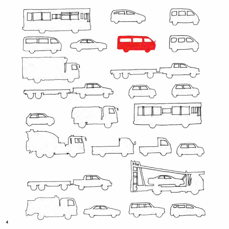
Vehicle-Borne ThreatsIt is critical to have a clear understanding of the possible threat vehicle and attack method in order to design proportionate countermeasures. Vehicle-borne threats can range from opportunistic vandalism to well planned aggressive attacks by determined criminals or terrorists, with the load-carrying capability and manoeuvrability of a vehicle enabling delivery of a potentially large explosive device.
Whether detonated by timer, remotely or by suicide operative, the use of a vehicle bomb (known as a Vehicle-Borne Improvised Explosive Device – VBIED) is primarily designed to maximise structural damage to property and local infrastructure, creating widespread disruption and publicity. Human casualties are inevitable with serious and fatal injuries being caused by blast effects, structural collapse and high-velocity fragmentation. The main causes of catastrophic structural damage and serious or fatal injury result both from the direct physical effects of an IED and subsequent building collapse or flying and falling debris.
Specific methods employed by those with hostile intent to gain access to a public space or to deliver a VBIED can be expected to develop over time and will continue to exploit any vulnerabilities within the physical environment. Consequently, the design of our public spaces should have the flexibility to adapt to evolving threats.
5
Securityshould be proportionate to
Threat

There are five main types of vehicle-borne attack:
Methods of Vehicle-Borne Attack
6
1. Parked vehicles An attack may come from a VBIED in a parking area of unscreened vehicles which may be underneath or adjacent to an intended target.
2. Encroachment Incomplete or incorrectly spaced HVM measures can allow a hostile vehicle to enter an area without the need to ram through a physical perimeter. A hostile vehicle may also be able to tailgate a legitimate vehicle through a Vehicle Access Control Point (VACP).

3. Penetrative attackThe use of the front or rear of a vehicle as a ram to breach a perimeter or target premises in order to get a hostile vehicle closer to the intended target.
Vehicle-Borne Improvised Explosive Device
‘VBIED’ 7

8
Additional threats that exploit or manipulate human weakness include:
4. Deception Various forms include use of stolen or cloned ID, verbal deception, Trojan horse or disguised vehicle.
5. DuressDuress imposed on the occupant of a legitimate vehicle to carry a hostile payload into a protected site or duress imposed on a guard to grant vehicular access through a Vehicle Access Control Point (VACP).
9
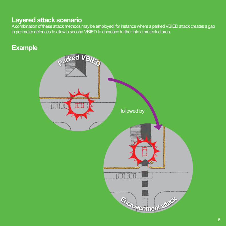
Layered attack scenarioA combination of these attack methods may be employed, for instance where a parked VBIED attack creates a gap in perimeter defences to allow a second VBIED to encroach further into a protected area.
Example
followed by
Parked VBIED
Encroachment attack

The effects from a VBIED include a blast wave, fire ball, primary and secondary fragment damage and ground shock.
Blast stand-off distance is the single most important factor in determining the extent of damage that can be caused by any VBIED. The ability to maximise this distance will always be site-specific, but early consideration in the design process will enable optimum solutions to be achieved.
Blast stand-off is used to keep a potential VBIED away from a protected asset thus limiting the damage caused by blast effects. Adequate blast stand-off distance can be enforced through the use of physical barriers and effective traffic management.
Blast Effects & Mitigation
Blast stand-off distance
If retrofitting HVM measures in an existing built environment, it may be difficult to maintain ideal stand-off distances, particularly in urban areas. Careful planning is required as every additional metre of stand-off will have a significant influence on the ability to mitigate blast. In more constrained sites, particular emphasis should be given to site or district-wide security, avoiding direct approach routes, managing maximum vehicle approach speed and installing threshold HVM measures.
10

Every
metre c
ounts
11

12

Part 2 Design Response
The Role of Design Inspiration > Innovation > Integration
Inspiration Key Design Principles + Reference
Urban Scenarios District + Site + Threshold
ProcessDesigner’s HVM Checklist
13
14

Early Consideration + Creative Thinking = Successful Integrated Design Solutions
Role of DesignA fresh approach is required from designers of the public realm to ensure that Hostile Vehicle Mitigation (HVM) measures are integrated seamlessly into the environment, providing proportionate security whilst also creating beautiful places. This section explores design thinking and technical information to demonstrate different approaches to these challenges.
Along with many other public realm design drivers, security issues should be considered from the outset to ensure that HVM measures are woven successfully into the fabric of new proposals. As security becomes an increasingly significant factor, it is important that a holistic approach is taken to develop integrated strategies that provide appropriate and balanced responses.
In some instances, particularly within existing built environments, HVM measures will not have been considered at the outset and solutions may need to be retrofitted. Unless well thought through and designed, these solutions may provide less effective security, be more costly and have a negative visual impact.
Interventions will vary from a macro scale of site masterplanning to a micro scale of detailed physical restraints. Some will be discreet and some may be overt. Every scenario will be different and solutions must always cater for site specific requirements.
15

DistrictThreshold SiteAsset
Holistic securityAs well as integrating HVM measures into the public realm, it is important to follow a holistic approach to overall security. Such an approach will acknowledge and respond to the interdependence of physical measures with electronic and procedural security measures (for example Intruder Detection Systems [IDS], Close Circuit Television [CCTV] or search and screening) to ensure that overall security is enhanced rather than compromised.
The level of threat in a public space may vary at different times of the day or year. Effective security design will recognise these fluctuations and schemes can be flexible using re-deployable or contingency solutions at peak times of crowd density or during a special event. Layered approach Successful security is most effective when implemented on a number of geographic layers. In terms of HVM, layers can feature access control and vehicle management on a district level, design of approach routes, further vehicle management and stand-off distances within the local site context and finally, control of stand-off distances and secure threshold design to the immediate vicinity of the asset.
What Makes a Place Secure?
16
Worked examples of each scenario are shown on the ‘Urban Scenarios’ pages.
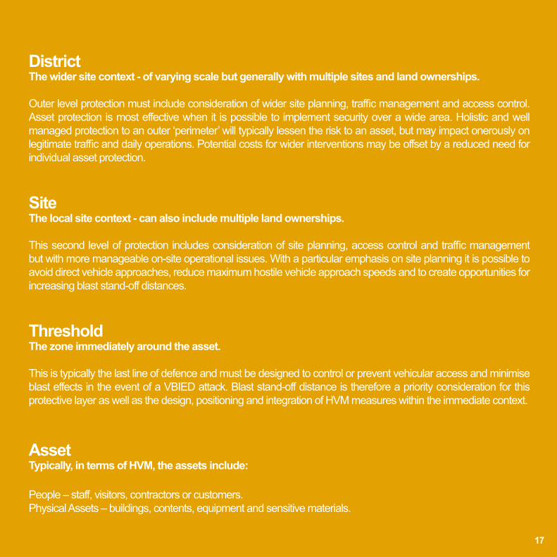
District The wider site context - of varying scale but generally with multiple sites and land ownerships. Outer level protection must include consideration of wider site planning, traffic management and access control. Asset protection is most effective when it is possible to implement security over a wide area. Holistic and well managed protection to an outer ‘perimeter’ will typically lessen the risk to an asset, but may impact onerously on legitimate traffic and daily operations. Potential costs for wider interventions may be offset by a reduced need for individual asset protection.
Site The local site context - can also include multiple land ownerships. This second level of protection includes consideration of site planning, access control and traffic management but with more manageable on-site operational issues. With a particular emphasis on site planning it is possible to avoid direct vehicle approaches, reduce maximum hostile vehicle approach speeds and to create opportunities for increasing blast stand-off distances.
Threshold The zone immediately around the asset. This is typically the last line of defence and must be designed to control or prevent vehicular access and minimise blast effects in the event of a VBIED attack. Blast stand-off distance is therefore a priority consideration for this protective layer as well as the design, positioning and integration of HVM measures within the immediate context.
Asset Typically, in terms of HVM, the assets include: People – staff, visitors, contractors or customers. Physical Assets – buildings, contents, equipment and sensitive materials.
17

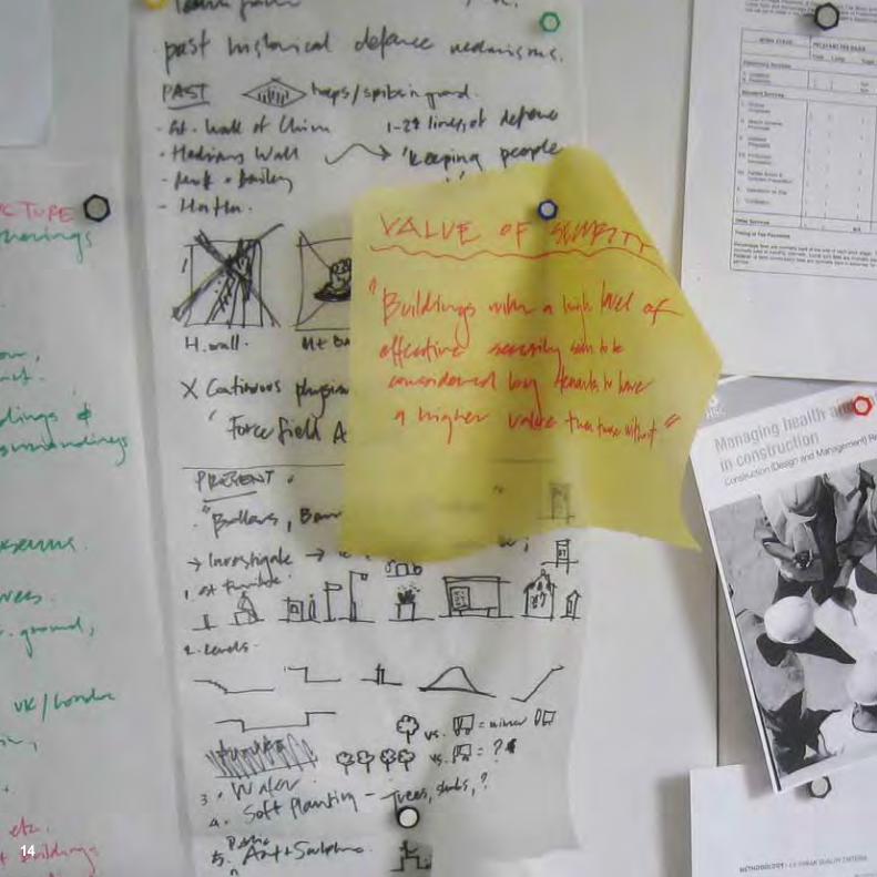
Historic Design for DefenceInspiration can be taken from the historic evolution of security measures and early approaches to defence which frequently utilised a layered strategy. A similar strategy known as ‘defence-in-depth’ is also familiar as a security policy in modern industries such as nuclear engineering and information technology.
Innovation is always required to respond to the evolving nature of threats but many principles will remain a constant. The motte and bailey is an excellent model demonstrating many of these principles as follows:
Layered defences designed to weaken the attack on the advance towards the asset;
Height advantage over the source of attack, providing natural surveillance, maintaining clear lines of sight and allowing early detection of attack;
Strengthened fortifications and manipulation of the terrain to deter and delay an attack.
Motte and bailey Final layer of defenceCastle and moat - controlled site access
••
•The additional use of a ditch or moat around a castle ensured that access was reduced and fewer points of entry had to be monitored. These fortified thresholds assisted in controlling access to the asset.
18

Flora and fauna have developed, through evolution, specific mechanisms which offer defence against attack and opportunity for survival. These are many and varied, from overt visual warning and physical deterrents to more discreet camouflage and evasion strategies. The principal strategies include resistance, tolerance and diversion:
Physical defence mechanisms, such as spikes, spines, serrations and body armour deter and protect in the natural world by establishing stand-off distances and preventing access to vulnerable parts;
Mechanical response to touch (thigmonasty), most spectacularly demonstrated by the Venus fly-trap, is also used by plants as a deterrent to attack;
Chemical defence, a resistance most commonly associated with plants, is also used by animals such as frogs and butterflies;
Having the flexibility to adapt to situations and immediate context through camouflage and seasonal or daily variation in form can reduce the risk of attack and provide defence through diversion;
Early warning can be provided by natural surveillance to ensure preparation and readiness against a potential attack. Alarm calls from prey animals are used to warn others and so provide protection to a wider community.
Nature’s Design Response
Fortified and layered protection Surveillance provides early warning Diversion through camouflage
•
•
•
•
•
19

20
The level of intervention should be proportionate to the assessed vehicle-borne threat and sympathetic to the day-to-day site operations such as servicing, deliveries and visitor drop-off. Ideally the application of traffic management should create an enforceable blast stand-off perimeter around the protected asset and minimise the amount of traffic requiring site access. The following traffic management options can be utilised:
(a) Vehicle exclusionIn certain situations total vehicle exclusion enforced by Vehicle Security Barriers (VSBs) may be appropriate.
(b) Vehicle inclusion In other instances, access for authorised vehicles such as emergency, utility and postal services may need to be accommodated through a Vehicle Access Control Point (VACP) and should be carefully managed.
(c) Temporary protectionTemporary or re-deployable VSBs may be employed at times of heightened threat or pre-planned special events. These barriers require specialist equipment to deploy, tend to be more visually intrusive and less pedestrian- permeable than permanent solutions.
(d) Traffic calming methodsThe application of horizontal deflections (eg. bends and chicanes) that are enforced by VSBs (to prevent over-running) will limit hostile vehicle approach speed thus reducing the effectiveness of a penetrative vehicle impact. In turn this can reduce the requirements and associated costs of countermeasures and provide opportunities to deploy discreetly integrated protection.
Traffic Management

P21 vehicle exclusion
P21 chicane
21
(a)
(c) (d)
(b)

A Small Decrease in Velocity =
22
Reduced Impact =
* Correctly designed traffic calming measures will reduce maximum hostile vehicle speeds (and the vehicle’s associated impact energy)
=
Potential for Less Intrusive, Physically Smaller and Lower Cost VSBs
A Large Decrease in Energy *
“Reducing hostile vehicle approach speed, significantly mitigates
the threat from penetrative vehicle-borne attack.’’

A direct route towards an asset allows a hostile vehicle to build up speed on approach.
Moving a road, or an asset, to create an indirect approach will lead a hostile vehicle away from the asset.
Removing vehicle access from the front of an asset removes the potential for using a vehicle as a weapon and establishes a stand-off distance from parked hostile vehicles.
Chicanes and offset approaches to an asset reduce hostile vehicle approach speed.
23

Pedestrian Movement
Summary of findingsAt all observed locations and under normal travel conditions, the presence of bollards did not reduce the route capacity or comfort to a level where pedestrians avoided using a particular route.
The design of entrance/exit environments, distribution of destinations in the surrounding urban environment, and the resulting pedestrian desire lines means that even in peak periods, observed locations remained within recommended upper limits for pedestrian density and flow rate.
Bollards influence individual pedestrian behaviour, however the effects are subtle and can be difficult to identify or measure. Pedestrians were observed to avoid conflicts by pausing for a fraction of a second or twisting at the hips or shoulders to pass between bollards at the same time as other pedestrians. These adjustments maintained pedestrian speed and minimised any reduction in convenience.
As security requirements mean that bollards should be located externally in arrangements that maximise blast stand-off distance, positioning of bollards in areas operating close to acceptable limits of pedestrian movement should therefore be avoided. However, detailed study of pedestrian movements is likely to be required in complex situations.
Bollards and the design processDesigning bollard arrangements with regard topedestrian movement is critical for the successful operation of a site.
To make objective decisions on the design of the public realm, a number of tools and techniques can be used to develop an understanding of pedestrian flow conditions, such as:
• Conducting a desktop review of the site and context to identify pedestrian desire lines;
• Walking similar sites, before and after project completion to get a first-hand experience;
• Observing existing pedestrian flow characteristics where installations are proposed;
• Simulating pedestrian reaction to site modifications using computer software;
• Temporarily trialling proposed modifications at the actual site.
It is important that these methods are selected and applied in a manner appropriate to the project needs, and undertaken by a competent individual following recognised best practice. Particular attention should be given to the accurate simulation of pedestrian movement, where the simulation output can be sensitive to a number of set up parameters as well as the user objectives and their simulation expertise.
When considering the installation of HVM measures in the public realm, designers should take a holistic approach to ensure an appropriate level of physical protection is provided whilst minimising any negative impact on pedestrian movement. Sites that experience high volumes of pedestrian use must accommodate movement safely, and at the required level of comfort and convenience. A number of tools and techniques are available to develop a comprehensive understanding of pedestrian flow, such as; desk top surveys to identify pedestrian desire lines, walking similar sites to gain first hand experience, observing existing pedestrian flow characteristics, simulation tests using validated computer software and full scale trials of proposed modifications on the actual site.
Where pedestrian movement is affected, the influence of bollards can be seen in the behaviour of pedestrians located in the immediate vicinity. For example, under normal conditions, bollards spaced at 1200mm air gaps have, at most, a minor effect on pedestrian convenience, which includes making changes to body position or reducing walking speed for a short amount of time (less than one second). Also, under normal conditions the presence of such bollards has not been seen to affect pedestrian health and safety.
HVM measures have less effect on pedestrian movement (including collisions with other pedestrians, reductions in speed or detours from a preferred route) than other commonly occurring urban features such as retail kiosks or newspaper vendors.
The guidance within the Disability Discrimination Act 1995 and Equality Act 2010 should be considered - for example a visually impaired person using a long cane or with an assistance dog needs 1100mm width, whilst it is recommended a wheelchair requires a 900mm width. In using this guidance it should be noted that the design of a HVM scheme must achieve a balance between multiple operational and security requirements.
24

Four CsPedestrian movement parameters can be evaluated to investigate if, and how, any are influenced by the design of a physical environment that includes a HVM scheme. Pedestrian movement is influenced by the following inter-related factors:
Capacity Rate at which pedestrians can safely pass through a space during a defined period of time.
Flow rate is measured in people per minute per metre (p/min/m). This measure is used to assess whether the speed and density of pedestrian movement remains within acceptable levels. A recommended maximum pedestrian flow rate is defined as 82 p/min/m. †
Comfort Amount of personal space available to pedestrians and the ability to move freely.
Described in terms of pedestrian density, measured in people per square metre (p/m2) with a recommended maximum pedestrian density defined as 40 people per 10m2 †. The space per pedestrian, measured in square metres per person (m2/p), is used to assess the “level of service” with multiple comfort scales defined. ‡
Convenience Ability of a person to follow their preferred route between two points at their favoured speed.
A “desire line” describes a person’s preferred route through a space. Actual routes taken can be measured in terms of speed, journey duration and distance.
Conflict A discrete event that alters the natural flow of movement.
Conflicts can occur between pedestrians and the physical environment, or between two or more pedestrians. Conflicts can include collisions or behaviours necessary to avoid a collision such as stopping or sudden changes of direction.
† Department for Culture Media and Sport (DCMS) 2008. ‡ Transport for London (TfL) 2010, Fruin 1987.25

Capacity
Flow RateIndicates the density and speed of pedestrian movement through a space. Under normal travel conditions, pedestrian flows often concentrate at specific parts of an entrance/exit space - areas in alignment with wider pedestrian desire lines are likely to record higher levels of use.
Flow Behaviour Where bollards are arranged in straight lines perpendicular to the direction of movement, there is very little divergence from desire lines. Pedestrians are able to deal with bollards by raising their hand to avoid making contact, or if necessary by turning to fit through the air gap between bollards at the same time as another pedestrian.
Where bollards are arranged in straight lines parallel to movement (such as along a kerb edge), pedestrians avoid walking in the spaces between bollards and leave a more noticeable separation distance.
26
BollardNeglected space

Comfort
DensityUnder normal travel conditions, the highest pedestrian densities are found in locations that form part of wider pedestrian desire lines; especially where these desire lines overlap or converge. This indicates that the configuration of the surrounding urban environment has a greater influence on typical pedestrian densities than the presence of bollards or other HVM measures.
Route ChoiceFeatures such as building entrances, pedestrian crossings and underground stations are seen to have a greater effect on pedestrian speed and level of comfort than the presence of HVM measures.
27
BollardNeglected space
Convenience
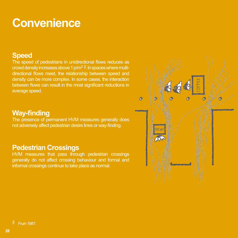
SpeedThe speed of pedestrians in unidirectional flows reduces as crowd density increases above 1 p/m2 §. In spaces where multi-directional flows meet, the relationship between speed and density can be more complex. In some cases, the interaction between flows can result in the most significant reductions in average speed.
Way-findingThe presence of permanent HVM measures generally does not adversely affect pedestrian desire lines or way-finding.
Pedestrian CrossingsHVM measures that pass through pedestrian crossings generally do not affect crossing behaviour and formal and informal crossings continue to take place as normal.
§ Fruin 1987.
28

Conflict
Pedestrian ConflictsMore conflicts are observed to take place where a combination of certain pedestrian flow conditions and poor design of the physical environment are present: - Multiple strong flows meet or cross;
- Restricted visibility between flows reduces time for negotiation between pedestrians and adjustment of speed and direction; - Limited space increases pedestrian/crowd density, particularly where multiple flows interact;
- Stationary pedestrian activity such as localised queuing or waiting occurs; - Introducing HVM measures into environments where a combination of these conditions occur could increase the likelihood of conflict.
29
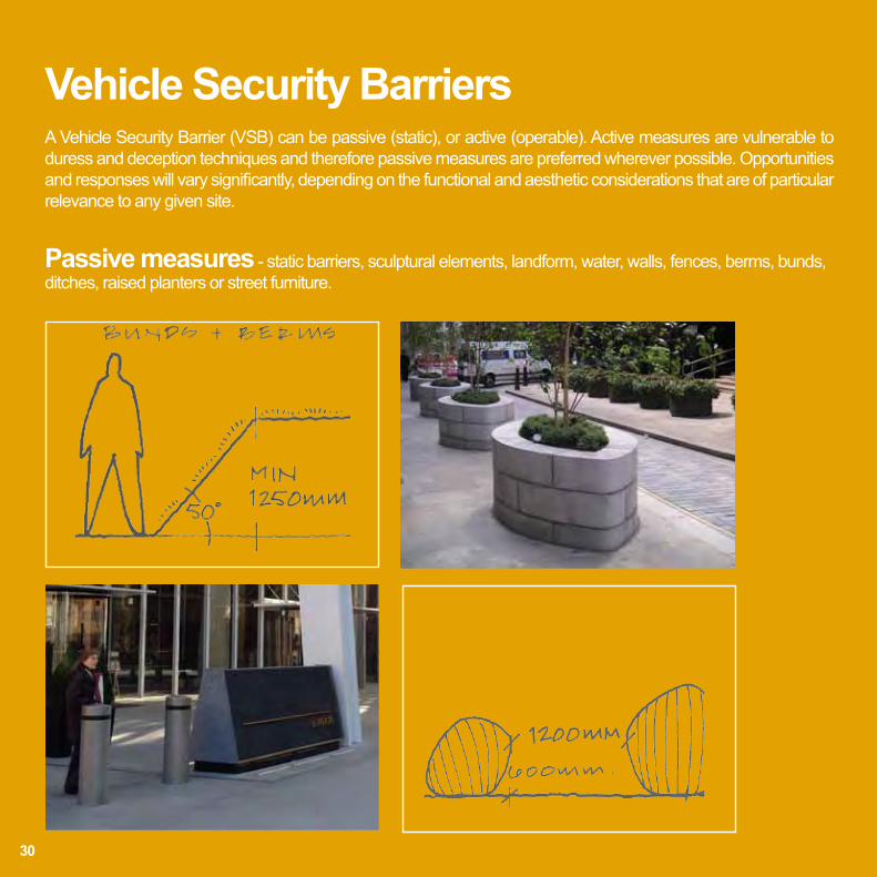
A Vehicle Security Barrier (VSB) can be passive (static), or active (operable). Active measures are vulnerable to duress and deception techniques and therefore passive measures are preferred wherever possible. Opportunities and responses will vary significantly, depending on the functional and aesthetic considerations that are of particular relevance to any given site.
Vehicle Security Barriers
30
Passive measures - static barriers, sculptural elements, landform, water, walls, fences, berms, bunds, ditches, raised planters or street furniture.

31
Active measures - operable blockers, bollards, gates, rising, sliding, swinging and retracting manually or powered.
P31 sliding bollard

The maximum clear distance between adjacent VSB elements or other structural elements must be no greater than 1200mm. This dimension is designed to prevent encroachment of vehicles beyond the blast stand-off perimeter, whilst maintaining access for pedestrians, wheelchairs and pushchairs. The 1200mm clear dimension must be measured between structural elements at a height of 600mm above ground level.
The minimum height for vertical fixed structures is 500mm. However an increased height of 900mm or more will make the measure more conspicuous, assist the visually impaired and typically reduce the penetration of an impacting hostile vehicle. All vertical elements selected to prevent vehicle access should be fit for purpose and successfully tested or conform to ISO International Workshop Agreement (IWA) 14-1 ‘Vehicle security barriers – Part 1: Performance requirement, vehicle impact test method and performance rating’ or BSI Publicly Available Specification (PAS) 68 ‘Impact test specifications for vehicle security barrier systems’ or CEN Workshop Agreement (CWA) 16221 ‘Vehicle security barriers - Performance requirements, test methods and application guidance’.
Further advice for the application of these elements can be referenced to IWA 14-2 ‘Vehicle security barriers – Part 2: Application’, BSI PAS 69 ‘Guidance for the selection, installation and use of vehicle security barrier systems’ or CWA 16221.
CPNI can assist in the selection of appropriate countermeasures or structural elements for incorporation within a designer’s vision.
Technical Requirements
32

“1200mm maximum between structural elements.’’
33
34

35
InspirationSix key principles have been identified in delivering successfully integrated Hostile Vehicle Mitigation in the public realm. A site-specific response is essential in delivering effective and appropriate measures.
Consider forward planning and flexibility to counter developing threats
Provide mitigation measures proportionate to the threats
Design to enhance the setting
Include multi-functional elements
Ensure an accessible and inclusive environment
Design with maintenance in mind
1
2
3
4
5
6
6 Key Design Principles

36
The following pages illustrate a selection of elements, from public art to street furniture, which could be adapted and developed (in terms of structure and dimensions) to provide integrated HVM:
• Public Art & Culture
• Water
• Play
• Seating
• Street Furniture
• Topography & Levels
• Walls & Fences
• Incidental Street Elements
Design Reference
37
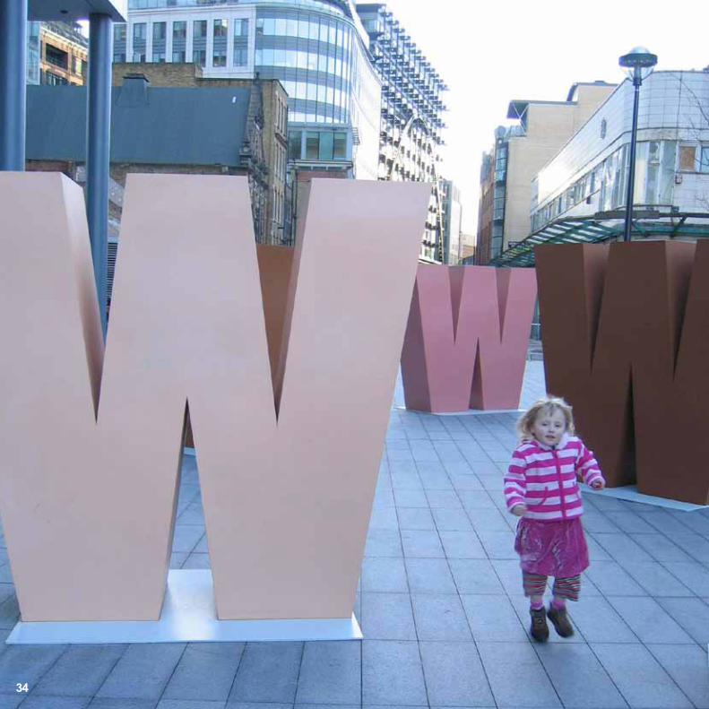
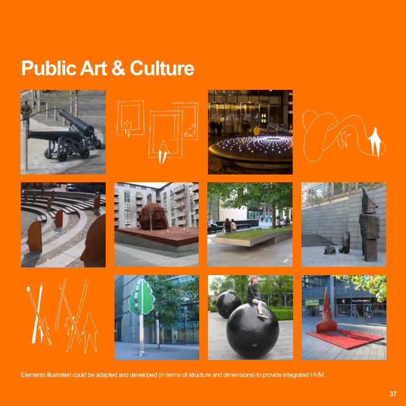
Public Art & Culture
Elements illustrated could be adapted and developed (in terms of structure and dimensions) to provide integrated HVM.

Water
38
Elements illustrated could be adapted and developed (in terms of structure and dimensions) to provide integrated HVM.
Play
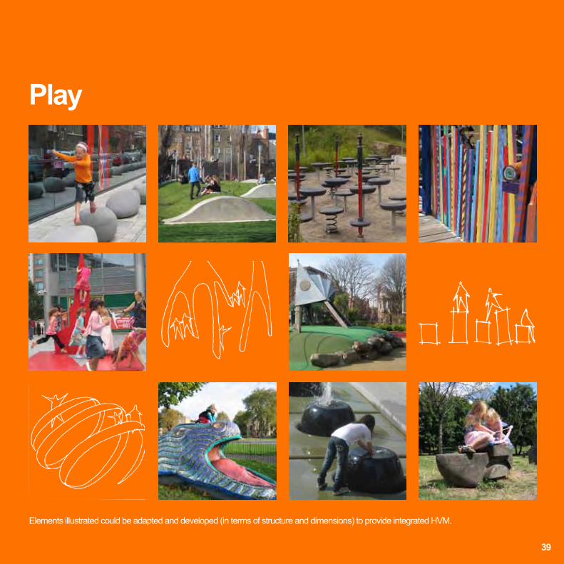
39
Elements illustrated could be adapted and developed (in terms of structure and dimensions) to provide integrated HVM.

Elements illustrated could be adapted and developed (in terms of structure and dimensions) to provide integrated HVM.
Seating
40

Elements illustrated could be adapted and developed (in terms of structure and dimensions) to provide integrated HVM. Elements illustrated could be adapted and developed (in terms of structure and dimensions) to provide integrated HVM.
Street Furniture
41
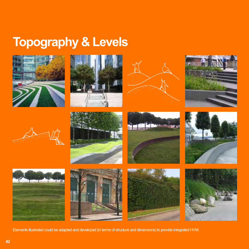
Topography & Levels
42
Elements illustrated could be adapted and developed (in terms of structure and dimensions) to provide integrated HVM.

Walls & Fences
43
Elements illustrated could be adapted and developed (in terms of structure and dimensions) to provide integrated HVM.

Incidental Street Elements
44
Elements illustrated could be adapted and developed (in terms of structure and dimensions) to provide integrated HVM.

Diversity of the Public Realm =
Opportunities for Integrated HVM
45

ThresholdAsset46

DistrictThreshold Site
Urban ScenariosThe following section examines potential strategies and proposals for three urban scenarios, each with different requirements and constraints.
Scenario 1: District Scenario 2: SiteScenario 3: Threshold
47

TRAFFIC MANAGEMENT + AC
CESS
CON
TRO
L
Response
ASSET SET WITHIN TIGHT URBAN LAYOUT /
STREETSCAPE MAY BE A CLUSTER OF ASSETS
AND THEREFORE SENSITIVE LOCATION.
CONDUCT SITE OBSERVATION TO ASSESS FOUR Cs.
RISK FROM HOSTILE VEHICLES:
• Either VBIED, or use of vehicle as a weapon
AT DISTRICT LEVEL CONTROLS CAN BE IMPLEMENTED
AT A RANGE OF SCALES FOR MAXIMUM EFFECT INCLUDING:
• Site planning
• Traffic management
• Access and control management
REDUCES THE ABILITY AND THEREFORE THE RISK OF A
HOSTILE VEHICLE ACCESSING THE AREA AROUND AN ASSET.
LAYERED APPROACH
DEFENCE STRATEGY
DISTRICTVehicle screening.Manual / automated systems.Traffic management / vehicle exclusion.
Asset vulnerable from direct vehicular approach. Potentially high speeds achievableHIGH VELOCITY = HIGH IMPACT
Reduce risk of VBIED + vehicular attack near asset
Reduce potential for parked vehicles• Encroachment• Penetrative attack
Approaches that are parallel or oblique to asset reduce risk of high velocity impact
Total vehicle exclusion?Vehicle screening?
LOCALISED PROTECTION OF ASSET
Considerations:Mobility / pedestrian access and flow / aesthetics / physical constraints / costs / maintenance.
Analysis
SITEEmergency access only.Establish maximum stand-off distance in case district level controls are breached.Public realm - control vehicular approach speed to asset.
THRESHOLD - ‘LAST LINE OF DEFENCE’Physical barriers integrated into public realm and building apron.May include: water, seating, furniture, sculptural, arts, play elements.
Consider the impact on way-finding
48
DistrictThreshold SiteAssetScenario 1: DistrictIncludes opportunities to influence the District, Site and Threshold
CONFIDENTIAL
Observation studies Key Findings Convenience Do VSBs affect way finding? VSBs were not observed to affect way-finding. At Stamford Bridge pedestrians move at the urban scale from the Stadium Exit to the Tube Station entrance following the most direct route. Part of this journey passes through the highest density and slowest moving crowds observed across all sites, yet still pedestrians chose to follow this route. The presence of VSBs did not affect pedestrian way-finding as much as their cognitive understanding of the surrounding urban context.
UNDERSTAND EXISTING WAY-FINDING THROUGH SITE OBSERVATION
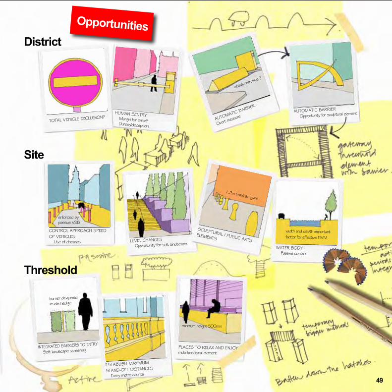
District
Site
Threshold
Opportunities
TOTAL VEHICLE EXCLUSION?HUMAN SENTRY Margin for error? Duress/deception
AUTOMATIC BARRIER
Overt measur
eAUTOMATIC BARRIER
Opportunity for sculptural element
WATER BODY Passive control
SCULPTURAL / PUBLIC ARTS ELEMENTSLEVEL CHANGES
Opportunity for soft landscape
CONTROL APPROACH SPEED OF VEHICLES Use of chicanes
INTEGRATED BARRIERS TO ENTRY
Soft landscape screening
ESTABLISH MAXIMUM
STAND-OFF DISTANCES
Every metre counts
PLACES TO RELAX AND ENJOYmulti-functional element
barrier disguised inside hedge
1.2m (max) air gaps
width and depth important factor for effective HVM
visually intru
sive ?
minimum height 500mm
enforced by passive VSB
49

Analysis
Response
AREA OF OPEN SPACE ADJACENT TO AN ASSET.
The area of open space or public realm may itself be an asset, especially during peak periods of activity (events + festivals) when attack would result in increased loss of life.
Ensure pedestrian conflicts are minimised.
AVAILABLE TOOLS
AT SITE LEVEL, CONTROLS CAN BE IMPLEMENTED AT BOTH SITE AND THRESHOLD LEVELS
REDUCE HOSTILE VEHICLE APPROACH SPEEDS:• Horizontal deflections - enforced by vertical elements• Vertical elements
CREATE OPPORTUNITIES FOR MAXIMISING STAND-OFF DISTANCES:• Elements integrated into the fabric of the public realm• ‘Dual / multi-purpose’ barriers• Holistic approach to security• Integrated public realm design• Consider existing desire lines and route choices
NATURE’S DESIGN
simple and robust
Use of chicanes assists in reducing vehicle approach speedsEnforce with passive VSB
Direct and unimpeded vehicular approach
Risk of VBIED in parked cars to side of asset
Active barriers provide opportunity for vehicle screening, reducing capability for hostile vehicles to access the curtilage of the asset
REQUIRES: • LOCALISED PROTECTION
OF ASSET• HIGH QUALITY PUBLIC REALM • COMMUNITY AMENITY VALUE
Maximise stand-off
Active barriers more susceptible to deception and duress techniques
water features and landscape as potential HVM
Threshold SiteAsset
Consider desire lines and pedestrian flows
50
Scenario 2: SiteIncludes opportunities to influence the Site and Threshold
CONFIDENTIAL
Observation studies Key Findings Convenience Way-finding The presence of permanent or temporary
bollards was not observed to change wider scale pedestrian desire lines. Pedestrians still chose to pass through bollards in order to follow wider scale intentions.
Flow rates (p/min/m) 26 to 35 23 to 26 20 to 23 17 to 20 14 to 17 11 to 14 8 to 11 5 to 8 3 to 5 0 to 3,
Liverpool Street Station – Pre implementation
Liverpool Street Station – Post implementation
STUDY AND ANALYSE PEDESTRIAN ROUTE CHOICE
Site
Threshold
Opportunities
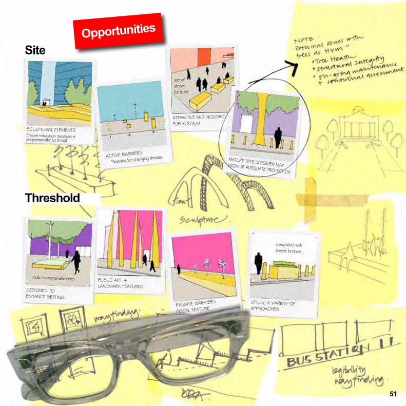
SCULPTURAL ELEMENTSEnsure mitigation measure is proportionate to threat
DESIGNED TO ENHANCE SETTING
PUBLIC ART +LANDMARK FEATURES
UTILISE A VARIETY OF APPROACHES
ACTIVE BARRIERS
Flexibility for changing threats
ATTRACTIVE AND INCLUSIVE
PUBLIC REALM
MATURE TREE SPECIMEN MAY PROVIDE ADEQUATE PROTECTION
integrated with street furniture
use of street furniture
multi-functional elements
PASSIVE BARRIERS
FOCAL FEATURE
51

Analysis
Response
ASSET SET WITHIN TIGHT URBAN GRAIN
This scenario looks at localised asset protection, where district
and site level controls are less favoured.
‘LAST LINE OF DEFENCE’
Restrict vehicular access
Minimise effects of damage in VBIED attack
Walk similar sites with and without HVM measures to gain first-hand experience
Consider other factors; kiosks, newspaper vendors, etc.
AVAILABLE TOOLS:
• Passive barriers
• Active barriers
INTEGRATED DESIGN SOLUTIONS COULD INCLUDE USE OF:
• Water
• Sculptural elements
• Flexible play
• Seating areas
• Areas of soft landscape
• Biodiversity
• Shade + shelter
• Topography and level changes
• Accessibility and inclusiveness
• Site furniture and seating
• Walls + fences
MAXIMUM 1200mm GAP BETWEEN BARRIERS TO PREVENT VEHICULAR ENCROACHMENT
RISK OF VBIED IN PARKED CARS TO SIDE OF ASSET
POTENTIAL FOR HOSTILE VEHICLE PENETRATION AND ENCROACHMENT
• Reduce/screen access to asset perimeter
• Maximise stand-off distances
• Robust mitigation measures
DESIGN TO ENHANCE THE SETTING
INCLUDE MULTI-FUNCTIONAL ELEMENTS
DESIGN WITH MAINTENANCE IN MIND
IDENTIFY PEDESTRIAN DESIRE LINES OF THRESHOLD AND SURROUNDING AREA
OBSERVE EXISTING PEDESTRIAN FLOW CHARACTERISTICS WHERE HVM MEASURES ARE PROPOSED
REVIEW EXISTING PEDESTRIAN
CONFLICTS TO INFORM THE
DESIGN PROCESS
Threshold SiteAssetScenario 3: ThresholdIncludes opportunities to influence the Threshold
52

OpportunitiesThreshold
TRAFFIC MANAGEMENT
Passive barriers
WATER WALL Design with maintenance in mind
1200mm MAXIMUM GAPSCULPTURAL SEATING Places to meet and socialise
ANIMATED WATER Acoustic benefit
MULTI-FUNCTIONALPotential for temporary yet sculptural solutions during peak period of risk?
SENSITIVE DESIGN IN RETROFIT
SCENARIOS
INTERACTIVE PLAY
SOFT LANDSCAPE Crisp seating edge SHADE + SHELTER
USE OF LEVEL CHANGE
PUBLIC ART Integrated seating + flexible play
53

54

Designer’s HVM Checklist
Process
55

Points to consider:
Consider liability and due diligence
Seek advice from CPNI, CTSAs and / or security professionals where necessary
Explore options for asset re-location to mitigate the threat
Consider wider strategic security proposal if applicable
Assess possibility of security measures extending beyond the client’s ownership boundary
Liaise with adjacent landowners to explore wider scale opportunities
Review requirement for security as an integral part of the design brief
Stage 1Preparation
As with many aspects of public realm design, early consideration of opportunities and constraints in relation to HVM is a crucial part of producing an integrated and holistic security strategy. It is equally important that these considerations are carried throughout the design process to delivery on the ground.
A long term commitment is also required to monitor and maintain the effectiveness of integrated security measures to ensure that design solutions continue to perform their role both in HVM and in providing beautiful places for all to enjoy. Particular issues for consideration at the various stages may include, but are not limited to, the following:
Designer’s HVM Checklist
Assess threat to the site and its adjacent buildings
Identify stakeholders
Review planning implications for wider area scheme
Walk the site to gain first hand experience as a user - consider desire lines
Apply appropriate tools & techniques to understand pedestrian movement
Trial pedestrian flows on site alongside a computer simulation to ‘stress test’ design layouts
Understand the importance of site observation work and other assessment methods
Consider the strengths and weaknesses of computer modelling
56

Points to consider:
Points to consider:
Sympathetic approach to public realm function and appearance
Holistic approach to HVM, consider future flexibility and evolving threats
Remember Four Cs - Capacity, Comfort, Convenience and Conflict
Ensure strategic site planning and layout doesn’t compromise security
Develop proposals in the context of existing or proposed local security strategies and plans
Explore opportunities for play, arts and culture
Explore potential for multi-functional elements
Clearly define boundaries to publicly accessible areas
Review opportunities for vehicular approach and access management
Ensure design does not compromise accessibility or pedestrian flows
Coordinate utilities with proposed VSB systems and required footings
Design with maintenance in mind
Consider preparation of formal management plan
Ensure security measures are proportionate to the threat
Implement continual assessment of HVM measures against current threats
Coordinate management plan with other local strategic plans Periodically review measures against changing threats or other varying circumstancesFully inform management and operators of site maintenance requirements
Consider the adoption of proposals and potential implications of ongoing maintenance
Stage 3Use
Stage 2Design
Consider contingency plans
Consider Health and Safety implications
Designs should be successfully impact-tested or incorporate proven structural design
Consider security and operational issues
Trial pedestrian flows on site alongside a computer simulation to ‘stress test’ design layouts
57

58

Appendix B Precedents & Glossary
Appendix A Further reference
Part 3
Appendices
59

Further referenceCentre for the Protection of National Infrastructure (CPNI)www.cpni.gov.ukThe Centre for the Protection of National Infrastructure (CPNI) protects national security by providing protective security advice. Protective security is ‘putting in place, or building into design, security measures or protocols such that threats may be deterred, detected, or the consequences of an attack minimised’.
We provide advice on physical security, personnel security and cyber security/information assurance. Most importantly, we explain how these components combine together and reinforce each other - and their relationship to the threat. CPNI’s protective security advice is built on a combination of:
• what science tells us (our research and development programme) • our understanding of the national security threat • our experience and expertise • effective relationships with private and public sector partners • policy considerations.
We prioritise to whom we give advice through various mechanisms for example a sector approach for national infrastructure, a criticality scale and the ‘Protect’ objectives of CONTEST (UK’s strategy for counter terrorism).
MI5www.mi5.gov.ukThe Security Service (MI5) is responsible for protecting the UK against threats to national security.
Joint Terrorism Analysis Centre (JTAC)www.mi5.gov.uk/home/about-us/who-we-are/organisation/joint-terrorism-analysis-centre JTAC is a multi-departmental organisation that analyses and assesses all intelligence relating to international terrorism on behalf of the UK Government.
National Counter Terrorism Security Office (NaCTSO)www.nactso.gov.uk The National Counter Terrorism Security Office (NaCTSO) is a police unit and forms part of the Association of Chief Police Officers (ACPO) Protect and Prepare. The unit is co-located with the Centre for Protection of National Infrastructure (CPNI.)
NaCTSO supports a nationwide network of specialist police advisers known as Counter Terrorism Security Advisers (CTSAs). The primary role of these advisers is to provide help, advice and guidance on all aspects of counter terrorism protective security (including HVM) across a variety of sectors.
Appendix A
60

Home Office www.gov.uk/government/organisations/home-officewww.gov.uk/government/policies/protecting-the-uk-against-terrorismResponsibility for co-ordinating the UK’s counter terrorism strategy (CONTEST) rests with the Office for Security and Counter Terrorism (OSCT) within the Home Office. OSCT’s primary responsibilities include supporting the Home Secretary and other ministers in developing, directing and implementing CONTEST.
Register of Security Engineers and Specialists (RSES)www.ice.org.uk/rses RSES has been established to promote excellence in the field of security engineering by providing a benchmark of professional quality against which its members have been independently assessed.
RSES is sponsored by the Centre for the Protection of National Infrastructure (CPNI) and is administered and operated by the Institution of Civil Engineers (ICE).
Department for Transport (DfT) www.gov.uk/government/policies/managing-the-risk-to-transport-networks-from-terrorism-and-other-crimesThe Department for Transport (DfT) aims to protect people and transport infrastructure while allowing transport systems to operate efficiently and effectively. This is by managing the risk of terrorist attack on the UK’s transport systems as part of the wider government counter-terrorism strategy.
Secured by Designwww.securedbydesign.comOfficial UK Police flagship initiative combining principles of ‘designing out crime’ with physical security.
Design Against Crime (DAC)www.designagainstcrime.comDAC is a practice-led design research project that emerged at Central Saint Martins College of Art and Design. The Centre’s focus is based on the understanding that design thinking as well as design practice can and should address security issues without compromising functionality, other aspects of performance, or aesthetics.
Landscape Institute (LI)www.landscapeinstitute.orgRoyal Chartered body for landscape architects in the United Kingdom.
Royal Institute of British Architects (RIBA)www.architecture.comProfessional association of architects in the United Kingdom.
Royal Town Planning Institute (RTPI)www.rtpi.org.uk/UK’s leading planning body for spatial, sustainable and inclusive planning.
61

Appendix A Continued
• Blast Effects on Buildings, D. Cormie / G. Mays / P. Smith (Editors). Publisher Thomas Telford Ltd, 2009
• CONTEST - The United Kingdom’s Strategy for Countering Terrorism, HM Government, July 2011
• CWA 16221:2010 Vehicle security barriers. Performance requirements, test methods and application guidance,
CEN, 2010
• Expecting the unexpected, NaCTSO / Business Continuity Institute. Publisher London First, 2010
• Guide to safety at Sports Grounds: Fifth edition. Department for Culture Media and Sport, 2008
• IWA 14-1:2013 Vehicle security barriers – Part 1: Performance requirement, vehicle impact test method and
performance rating, ISO, 2013
• IWA 14-2:2013 Vehicle security barriers – Part 2: Application, ISO, 2013
• PAS 68:2013 Impact test specifications for vehicle security barrier systems, BSI, 2013
• PAS 69:2013 Guidance for the selection, installation and use of vehicle security barrier systems, BSI, 2013
• Pedestrian Comfort Guidance for London, First edition. TfL, 2010
• Pedestrian Planning and Design, Revised edition. JJ Fruin, 1987
• Protecting against terrorism – Third Edition, CPNI, 2010
62
Protective security publications

63
• Protecting Crowded Places: Design and Technical Issues, HM Government, January 2012
• Secure in the knowledge, NaCTSO / The Security Service. Publisher London First, 2005
• TAL 1/11 Vehicle security barriers within the streetscape, DfT & CPNI, April 2011
• TAL 2/13 Bollards and Pedestrian Movement, DfT & CPNI, May 2013

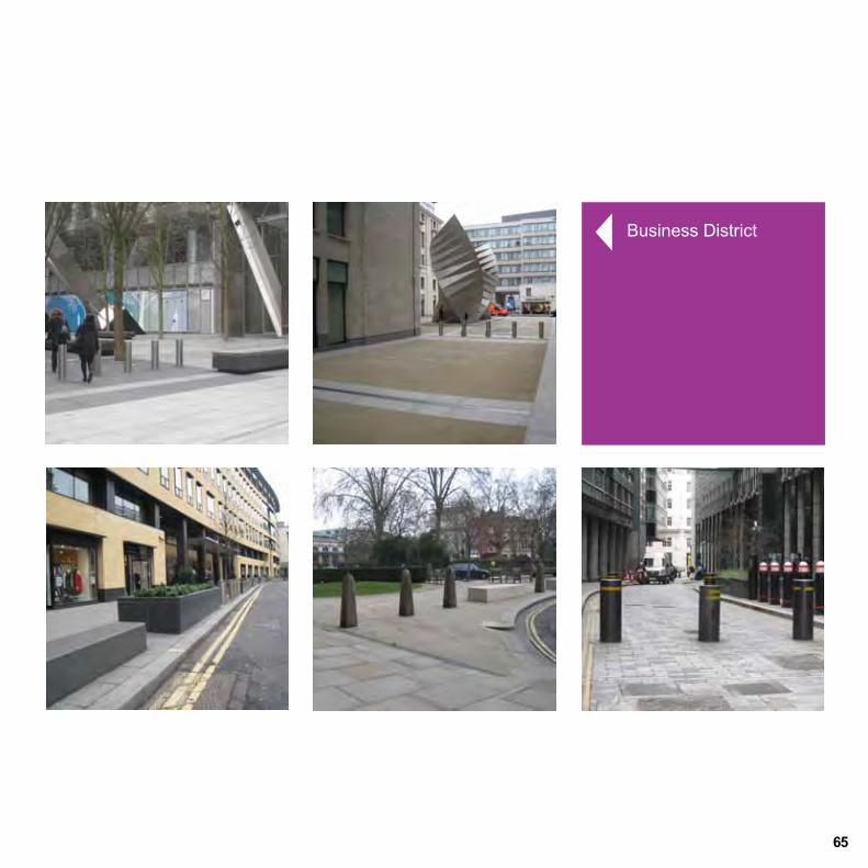
Appendix BPrecedents This section illustrates a range of HVM measures both in the UK and overseas. The images include a variety of new developments from business districts to transport hubs as well as interventions that are part of existing built environments, both recent and historic. Not all elements illustrated are structural but could be adapted as required to become part of a HVM scheme.
64
65
Business District

Precedents
66
Business District

67
Government Buildings
Government Buildings

Precedents
Streets & Squares
68

Streets & Squares
69

Precedents
70
Parliamentary Building
Landform

71
Airport
Railway Station

Visitor Attraction
Visitor Attraction
Precedents
72

73
Museum
Business Districts

Precedents
74
Active Measures
Passive Measures

75
Re-Deployable Systems
Re-deployable Systems

GlossaryBlast Stand-Off - Distance from the source of blast to the protected asset.
BSI - British Standards Institution.
CEN - European Committee for Standardisation.
CPNI - Centre for the Protection of National Infrastructure.
Curtilage - The area of land around a building or other structure.
CWA - CEN Workshop Agreement.
Desire Line - A path representing the shortest or most easily navigated route between origin and destination.
District - A region or locality.
HVM - Hostile Vehicle Mitigation.
IED - Improvised Explosive Device. An IED is a bomb fabricated in an improvised manner incorporating destructive, lethal, noxious, pyrotechnic, or incendiary chemicals and designed to destroy or incapacitate personnel or vehicles.
IWA - International Workshop Agreement.
MO - Modus operandi is a Latin phrase, approximately translated as “method of operating”.
Motte and BaileyA form of castle situated on a raised earthwork and surrounded by a protective fence.
Layered Approach - A multi-tiered approach to addressing the opportunities and challenges.
PAS - Publicly Available Specification.
PBIED - Person-Borne Improvised Explosive Device.
Public Realm - The public realm incorporates all areas of a village, town or city to which the public has open access.
Streetscape - The street patterns, furnishings and landscape that form the built environment.
Urban Grain - Pattern (morphology) of streets, buildings and other features within an urban area.
VACP - Vehicle Access Control Point.
VBIED - Vehicle-Borne Improvised Explosive Device.
View Corridor - A wide sightline within an urban context.
VSB - Vehicle Security Barrier.
76

Integrated Security A Public Realm Design Guide for Hostile Vehicle Mitigation - Second Edition
2nd Edition