integrated petrophysical evaluation for completion ... · integrated petrophysical evaluation for...
TRANSCRIPT

CEWELL, ONGC, Baroda-390009
P-194
Integrated Petrophysical Evaluation for Completion Optimization of
Horizontal Wells: A Case study from Mumbai Offshore
RR Tiwari*, CEWELL, ONGC, Baroda
RC Baishya, B&S Asset, ONGC, Mumbai
Summary
Vasai East field, which is the area of study of this work, is located in Mumbai Offshore. The development of the field was
undertaken about two years back. The development plan envisaged all horizontal wells in Bassein Limestone reservoir. This
reservoir is primarily a depleted thin-oil reservoir with a free gas-cap and a thick aquifer. Further, occurrences of severe to very
severe mud loss during appraisal drilling indicate presence of vugs, channels and karsts which may provide good to very good
horizontal and vertical permeability. This will in turn provide path to gas and water channeling during the production phase of
the reservoir. A good completion planning is, therefore, imperative to control water cut and gas channeling for optimizing the oil
production. The objective of this study was to identify potential threat zones, where such channels may buildup, and then to
segment the drain-holes with Swell-Packers during completion design so that such zones can be isolated, if required.
Integration of advanced logging tools (borehole imaging, dipole sonic and elemental capture spectroscopy) together with the
basic LWD log in the four wells of the field aided in the evaluation of the petrophysical properties. Borehole images captured the
fabric of the facies due to their high resolution imaging capabilities and sonic logs were processed for acoustic anisotropy and
Stoneley fracture and permeability results. The conventional logging-while-drilling data acquired in all the four wells was
incorporated in the study along with the elemental capture spectroscopy data to understand the gross lithology distribution.
The logged intervals in the study area revealed as much as four to five different facies in the horizontal wells. Some facies were
observed to have developed considerable secondary porosity (5-10%) due to vugs and dissolution activities. Such facies showed
varying degree of connectedness in the vugs and were studied carefully to understand their impact on production profile,
particularly in view of their near-vertical orientation which subsequently may pose a threat to gas or water breakthrough.
Stoneley permeability from sonic was also used to corroborate the connectedness information from image log. The shear wave
anisotropy analysis shows significant amount of anisotropy in some of the zones which is indicative of the presence of fractures
and fracture-like features in the vertical plane. This is further supported by change in facies seen on image log and significant
change in fluid mobility seen on Stoneley mobility.
Segmentation of zones with swell packers in a horizontal drain-hole on the basis of facies identification and their petrophysical
evaluation was done for the first time in ONGC to the best of our knowledge. Such completions will lead to better well control
against water and gas channeling.
Introduction Lateral heterogeneity in a reservoir is often ignored while planning a horizontal well. Whereas sandstone reservoirs may be considered laterally homogeneous over quite a large area, carbonates offer some shocking surprises even in a limited area. It is therefore prudent to consider lateral
heterogeneity in a carbonate reservoir while drilling and completing a horizontal well, particularly when the oil zone is thin and overlain and underlain by gas and water respectively. We face similar situation in Vasai East field of Mumbai Offshore which requires some innovative completion to avoid premature water and gas breakthrough.
Vasai East field is located in the east of main Bassein field which is a giant gas producing field. This field is connected to Bassein field at aquifer level. The reservoir was found sub-hydrostatic when the field was discovered in 2001. The reason for the sub-hydrostatic pressure was continuous gas production from the main field since 1988. Although the oil
column in Vasai East is thicker than the main field, the pressure depletion and the possible upward movement of oil-water contact were the main concerns while firming up the development plan of the field. Severe mud loss conditions during appraisal drilling indicated presence of vugs, channels and fractures and in fact the only vertical
Integrated Petrophysical Evaluation for
Completion Optimization of Horizontal Wells
2
development well drilled during development phase had to be abandoned because of uncontrolled mud loss situation. A karst mapping was carried out in the field which indicated presence of karsts throughout the field at all depth levels although their presence was more prominently seen
below oil-water contact. As the rest of development wells were planned to be drilled as horizontal wells because of comparatively thinner oil column, there was an apprehension that high horizontal and vertical permeability because of diagenetic changes may pose a threat to gas channeling from above and water cut from below. This would lead to premature well closure as no work-over is possible in a horizontal well.
At that stage it was planned to log all the wells with borehole imager and sonic along with normal logging-while-drilling suite to identify changes in facies along the well trajectory and also to identify vugs and fractures with their orientation. The idea was to identify zones with vertical and near-vertical orientation of fractures and solution channels, and segment them with swell packers so
that in the event these zones are found to provide conduit for gas and water, they can be isolated by suitable intervention. All the wells in this field are planned to be completed this way.
Method After the horizontal wells were drilled with LWD, the
borehole imager and sonic tools were lowered on drillpipe. The images were interpreted for the presence of solution channels and fractures, and their dips were computed interactively. Advanced modules like PoroSpect and BorTex (Schlumberger software) were run on the micro-scanner data to create porosity spectrum and to analyse the texture of the rock fabric. This helped in identifying the secondary porosity arising out of vugs and solution enhanced features and establishing a connectedness
coefficient which ultimately is related to permeability. Simultaneously the sonic log was also processed for Stoneley mobility with Schlumberger’s Poroelastic module. The cross-dipole information of the sonic tool was used to analyse the acoustic anisotropy of the formation which results in splitting of vertically propagating shear wave into a fast component and a slow component due to the presence of fractures and fracture-like features. The results from
these tools were integrated to identify zones with considerable amount of secondary porosity having good vertical connectedness. These zones were then segmented with swell packers for future interventions, if warranted.
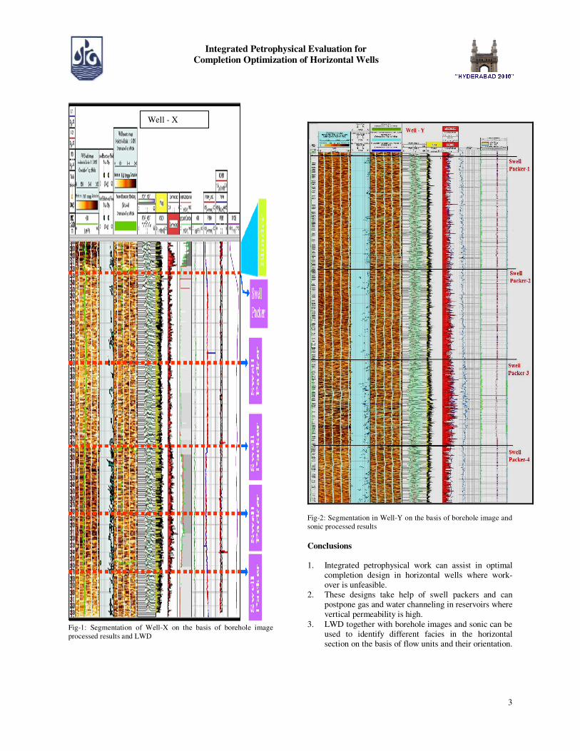
Examples Fig-1 shows the completion of horizontal section of Well-X
where only LWD and image log were recorded. The static
image shows the broad boundary of the litho zones while the dynamic image provides the details of the formation. A close examination of this horizontal section exhibits 3 to 4 different facies based on the presence of solution enhanced features. Facies with higher density of solution enhanced
features show good amount of invasion during drilling and the propagation resistivity of LWD reads lower value against these intervals. The connectedness coefficient derived from advanced image log processing shows a higher index against these intervals. Although the true dip of the beds is 3-4 degrees, the dip of these solution channels is high, in the range of 70-80 degree. It is therefore evident that the facies with high mud invasion
and good connectedness also have a near-vertical orientation of solution enhanced features. This in turn implies that although they may be good producers initially because of their good vertical permeability, later they are the potential threats for gas and water communication. This is the basis of deciding the swell packer stations. In the present well five swell packers have been used to segment the drain-hole section on the basis of reservoir facies. The
depths of swell packer stations are shown in the figure. The Intervals between Swell Packer-3 & 4 and 4 & 5 show high mud invasion, high density of solution enhanced features with near-vertical dip and high connectedness on image processed results. Swell Packer-1 is placed to prevent any gas channeling from gas-cap through casing annulus. Swell Packer-2 is simply a spacer and Swell Packer-5 is placed to segment the toe of the well.
Fig-2 is another well from the same field. In this well dipole sonic is also recorded besides LWD and borehole imaging. The facies showing high connectedness on image processed results also show high Stoneley mobility and high acoustic anisotropy. However the computed dip of the solution enhanced features and fractures is very high, of the order of 70-80 degree. These near vertical channels may initially exhibit good hydrocarbon producibility but may
offer a conduit to gas and water in the later stage of production. Like in the previous well, here too 3-4 different facies have been identified on the basis of density of solution enhanced features, their orientation and their connectedness. These facies have been segmented with the help of swell packers to facilitate future completion interventions. As shown in the figure, four swell packers have been used in this well to segment different facies.
Like in previous example, swell packer-1 is placed to prevent gas channeling from gas-cap through casing annulus. Swell packers 2 to 4 are placed to segment the facies seen on image log, taking into consideration the results from sonic processed log as well.
Integrated Petrophysical Evaluation for
Completion Optimization of Horizontal Wells
3
Fig-1: Segmentation of Well-X on the basis of borehole image
processed results and LWD
Fig-2: Segmentation in Well-Y on the basis of borehole image and
sonic processed results
Conclusions
1. Integrated petrophysical work can assist in optimal
completion design in horizontal wells where work-over is unfeasible.
2. These designs take help of swell packers and can postpone gas and water channeling in reservoirs where vertical permeability is high.
3. LWD together with borehole images and sonic can be used to identify different facies in the horizontal section on the basis of flow units and their orientation.
Well - X
Integrated Petrophysical Evaluation for
Completion Optimization of Horizontal Wells
4
Facies with high flow potential and near-vertical orientation of fractures and solution enhanced features are segmented with swell packers.
4. Segments having evidence of gas or water channeling at the later stage of production (on the basis of PLT)
can be closed without affecting the production from other segments.
5. Well performance monitoring and Well control of horizontal wells are easier in such completions and they make the work-over feasible.
Acknowledgement
Authors are thankful to ONGC Ltd. for providing resources to write this paper.