integrated live export facility, livingstone, nt
TRANSCRIPT

Notice of Intent
Integrated Live Export Facility, Livingstone, NT
Report Number 23919.78471
Prepared for
Wellard Rural Exports
Prepared by BRISBANE
1A Pakenham Street
Fremantle WA 6160
Telephone: (08) 9432 2800
ABN: 31 109 866 328
PO Box 1197
MILTON QLD 4064
Telephone: (07) 3367 0001
ABN: 56 135 005 999
_____________________________________________________________________________________ Report No 23919.78471
EnviroAg Australia Pty Limited © 2015 ___________________________________________________________________Page i
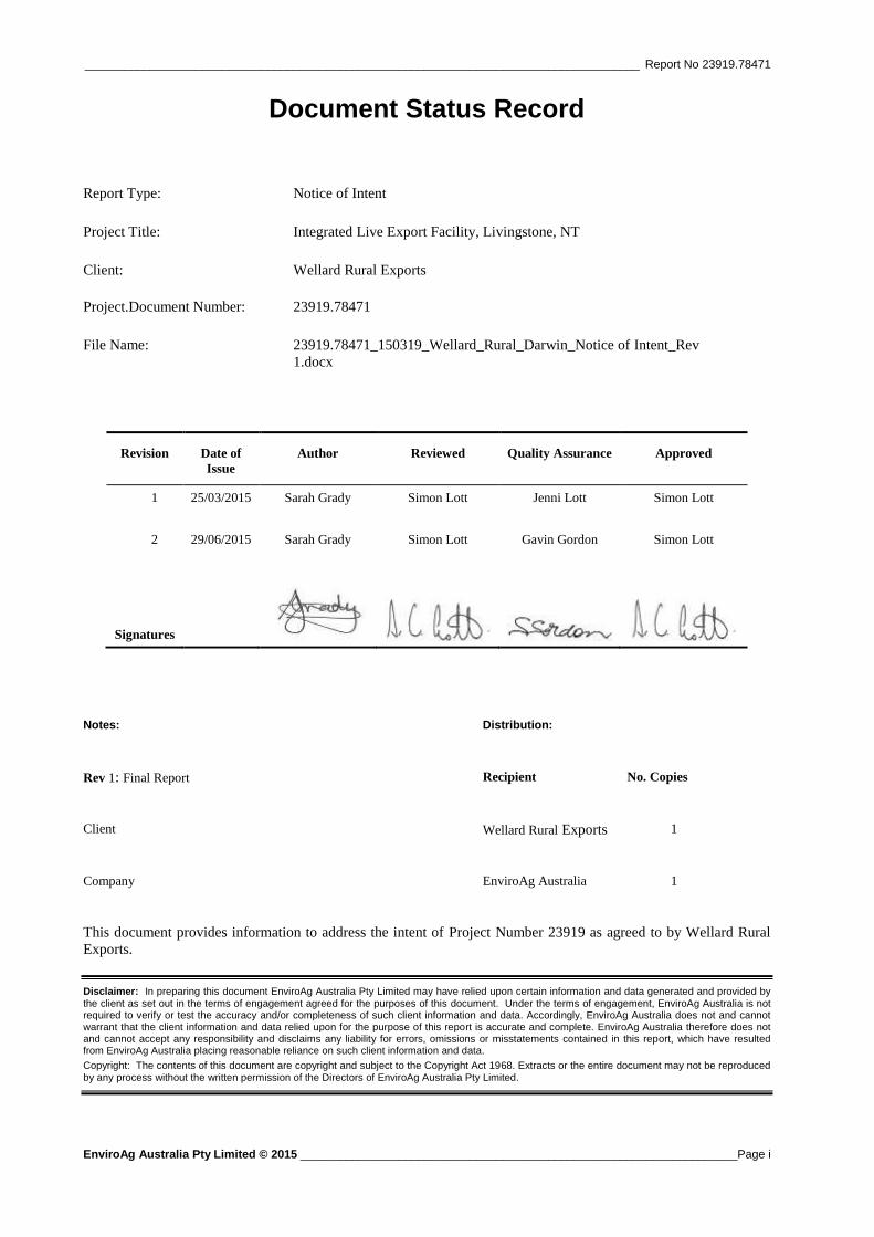
Document Status Record
Report Type: Notice of Intent
Project Title: Integrated Live Export Facility, Livingstone, NT
Client: Wellard Rural Exports
Project.Document Number: 23919.78471
File Name: 23919.78471_150319_Wellard_Rural_Darwin_Notice of Intent_Rev
1.docx
Revision Date of
Issue
Author Reviewed Quality Assurance Approved
1 25/03/2015 Sarah Grady Simon Lott Jenni Lott Simon Lott
2 29/06/2015 Sarah Grady Simon Lott Gavin Gordon Simon Lott
Signatures
Notes: Distribution:
Rev 1: Final Report Recipient No. Copies
Client Wellard Rural Exports 1
Company EnviroAg Australia 1
This document provides information to address the intent of Project Number 23919 as agreed to by Wellard Rural
Exports.
Disclaimer: In preparing this document EnviroAg Australia Pty Limited may have relied upon certain information and data generated and provided by the client as set out in the terms of engagement agreed for the purposes of this document. Under the terms of engagement, EnviroAg Australia is not required to verify or test the accuracy and/or completeness of such client information and data. Accordingly, EnviroAg Australia does not and cannot warrant that the client information and data relied upon for the purpose of this report is accurate and complete. EnviroAg Australia therefore does not and cannot accept any responsibility and disclaims any liability for errors, omissions or misstatements contained in this report, which have resulted from EnviroAg Australia placing reasonable reliance on such client information and data.
Copyright: The contents of this document are copyright and subject to the Copyright Act 1968. Extracts or the entire document may not be reproduced by any process without the written permission of the Directors of EnviroAg Australia Pty Limited.
_____________________________________________________________________________________ Report No 23919.78471
EnviroAg Australia Pty Limited © 2015 __________________________________________________________________ Page ii
Executive Summary
EnviroAg Australia Pty Ltd (EnviroAg) is assisting Wellard Rural Export Pty Ltd (Wellard’s) with the approval
process for development of a beef cattle pre quarantine export (PEQ) yard facility in Darwin. The proposed facility
is to be located next to an existing PEQ yard and neighbours the AA Co meat processing facility. The proposed
development is likely to supplement the existing “Santavan” PEQ yard.
This Notice of Intent is to provide relevant information to the Northern Territory EPA to allow the proposed
development to be assessed against the Territory and Federal legislative requirements. The development will apply
known design principles. It is a modest development (total capacity of the intensive animal facility of 5,000 SCU’s
and Feedmill) that will deliver, business, environmental, animal welfare and community benefits.
The proposed development site is located in the Hundred of Strangways in Livingston, Northern Territory. The site
is currently developed for cultivation and pasture production. The site is suitable for the proposed development as it
has Rural Zoning and it adjoins properties with similar developments.
The design delivers a state of the art facility which will enable Wellard’s to well manage the facility, limit
environmental impact and exercise best practice management of animal health and welfare.

_____________________________________________________________________________________ Report No 23919.78471
EnviroAg Australia Pty Limited © 2015 __________________________________________________________________ Page iii
Table of Contents
1. Introduction 1
2. Proponent details and contacts 1
3. Proposed Development 1
3.1 Location 3
3.2 Zoning 3
3.3 Employment 3
3.4 Economic Benefit 3
4. Legislative Requirements 7
5. Existing Geography 7
5.1 Landscape and Soils 7
5.2 Geology 8
5.3 Hydrology 8
5.4 Water Resources 9
5.5 Flora 9
5.6 Fauna 11
6. Environmental Risk Assessment, Management and Monitoring 12
6.1 Environmental Risk Assessment 12
6.2 Environmental Management 12
6.3 Environmental Monitoring 12
7. Proposed Assessment 15
8. Summary 16
9. Appendices 17

_____________________________________________________________________________________ Report No 23919.78471
EnviroAg Australia Pty Limited © 2015 __________________________________________________________________ Page iv
List of Tables
Table 1: Location details of the Livingstone ILEF site 3
Table 2: Desktop Threatened Flora Search Results 9
Table 3: Desktop Threatened Fauna Search Results 11
Table 4: (Preliminary) Risk Assessment of Proposed Development and Related
Environmental Factors 13
List of Figures
Figure 1: Aerial Image of a (Similarly Sized) Queensland Cattle Feedlot and Facilities 2
Figure 2: Cattle held in a semi-Confined PEQ Yard (courtesy of the Live Export Diaries) 2
Figure 3: Location of Wellard Live Export Facility; Livingston Valley South-East of
Darwin. 5
Figure 4: Site General Arrangement of the Integrated Live Export Facility 6
Figure 5 Land Unit of the Site (Blue Boundary) (NT Gov – NR Maps:2015) 8
Figure 6: Pasture and Cultivation on "Livingstone Valley" 10
Figure 7: Wellard Livingstone Site Vegetation Map 10
List of Appendices
Appendix A. EPBC Act Protected Matters Search Results A-1
Appendix B. Drawings & Design B-1

_________________________________________________________________________________________ Report No 23919.78471
EnviroAg Australia Pty Limited © 2014 _______________________________________________________________________ Page 1
1. Introduction
Wellard Rural Exports (Wellard’s) sells and exports livestock to overseas markets. It has a network of facilities across
several States in Australia. It has a significant market share of the live export trade in the Northern Territory. The
company has made a significant investment in the long-term future of the livestock export trade and is committed to it.
Wellard’s have been exporting from the Darwin for over 10 years.
Currently Wellard’s lease several pre-export quarantine (PEQ) holding yards close to and outside of Darwin. The
existing operations are spread across a number of leased sites with poor to adequate environmental and animal care
management. These present business, environmental and animal welfare risks to the Wellard’s business. Wellard’s
wish to proceed with the development of a new Integrated Live Export Facility (ILEF) so as to improve the overall
sustainability of their business.
EnviroAg Australia Pty Ltd (EnviroAg) is assisting Wellard’s with obtaining approval for development of a beef cattle
pre quarantine export yard facility in Darwin. EnviroAg has decades of experience in the approval, design and
construction of intensive livestock facilities through-out Australia. It is the author of State and National guidelines for
environmental management and operation of beef cattle feed yards.
2. Proponent details and contacts
The Proponent for this proposal is:
Wellard Rural Exports Pty Ltd (Wellard’s)
1A Pakenham Street,
Fremantle WA 6160
Telephone: (08) 9432 2800
The Consultant for this proposal is:
EnviroAg Australia (EnviroAg)
Dr Simon Lott
6/1 Fort Lane,
Milton QLD 4064
Telephone: 1800 445 389
Email: [email protected]
3. Proposed Development
The development consists of the following infrastructure;
(i) Care takers house;
(ii) Commodity and fodder storage sheds;
(iii) Feedmill;
(iv) Freshwater storage (ring tank and clean water tanks); for capture and storage of roof runoff and storage of
ground waters for stock water supply;
(v) Pre-Export Quarantine (PEQ) holding yard (Average holding capacity 3;000SCU; 12,000 SCU “peak”
short term (~5 day) holding capacity);
(vi) Livestock truck washing facility;
(vii) 2,000 SCU (Short term) feedlot; for holding stock for longer than 30 days;
(viii) Waste storage and treatment facilities; and;
(ix) Irrigation area for treated waste water reuse and hay / fodder production.
The proposed development consolidates existing Wellard’s operations onto a new site adjacent to an existing site. The
objective of this development is to deliver a net improvement and overall benefit to the business, the environment and

_________________________________________________________________________________________ Report No 23919.78471
EnviroAg Australia Pty Limited © 2014 _______________________________________________________________________ Page 2
the livestock to be exported. It is expected that there will be a resultant net positive benefit to the community, and to
Darwin and its port.
If the opportunity arose, the PEQ would be increased to 20,000 head (5,000 standard cattle units) as a second stage to
the development. This will not be progressed in the immediate future but will be taken into account in the design.
Figure 1: Aerial Image of a (Similarly Sized) Queensland Cattle Feedlot and Facilities
Figure 2: Cattle held in a semi-Confined PEQ Yard (courtesy of the Live Export Diaries)

_________________________________________________________________________________________ Report No 23919.78471
EnviroAg Australia Pty Limited © 2014 _______________________________________________________________________ Page 3
3.1 Location
The development is located on the property known as “Livingstone Valley” (Lot 5544 Hundred of Strangways;
Livingstone Valley) located on the Stuart Highway at Livingston, Northern Territory. It is situated 35 km south-south
east (SSE) of Darwin; 25 km south east of the Darwin harbour, and about 7kms west of Berry Springs. The nearest
neighbour is a farm residence some 1.25 km to the east-south-east.
The location of the property is shown in Figure 1 below. The proposed general arrangement is shown in Figure 2
below with the concept plan show on Drawing 30422.SP.01. The selected site is immediately adjacent to the
“Santavan” PEQ holding yard which is currently leased to Wellard’s. It has an area of 90.5 ha (or 220 acres).
Table 1: Location details of the Livingstone ILEF site
Parameter Value
Address “Livingston Valley” 2658 Stuart Highway, Livingstone, NT 0822
Land Parcel Type and Label Sec 5544
Town/Hundred Livingstone, Hundred of Strangways
Area 90.5 ha (220 acres)
Landuse zoning Rural
3.2 Zoning
The subject land is currently zoned Rural (NTPS, 2015). The Draft Darwin Regional Land Use Plan 2014 notes the
subject land as Rural / Rural Lifestyle and notes that agriculture and related niche business are important to such land
use structure and the Livingston municipality.
3.3 Employment
The work force that is estimated to be used by the facility is summarised below.
Export Facility = 3-4 permanents; up to 10 casual workers
Feedlot facility = 2-3 workers
Feedmill = 3-6 workers
Contract farmers = 2 workers
Total work force is expected to be > 20 at full development
This should be multiplied by 2-3 for ancillary work force; transport, vet, rural merchandise etc.
This work force is local and far more “sustainable” and beneficial for the regional community than that from a FIFO
mining operations. It will have a significant multiplier effect for Darwin, its surrounds and the Northern Territory.
3.4 Economic Benefit
3.4.1 Capital Worth
The development of the ILEF will be undertaken in three stages. The full development will have a capital cost of about
$12M (based on 2014 costs). The majority of this expenditure will be in the local Darwin business community
(contractors, materials and labour). A significant amount will be spent on the feed-mill, and sheds which are likely to
be manufactured inter-State and transported to the site for erection.
3.4.2 Operational Worth
The life of the development is expected to be greater than 40 years.

_________________________________________________________________________________________ Report No 23919.78471
EnviroAg Australia Pty Limited © 2014 _______________________________________________________________________ Page 4
Each year Wellard’s buy at least $50M worth of livestock from within the NT for export. About $5M is spent on
transport of livestock and $8M on fodder and feedstuffs for PEQ yards and feed for placement on ships. About $4M is
spent on port costs. Thus about $67M is expended in the NT.
Of the above expenditure it is expected that $2M will be spent each year on local labour and $3M on local fodder and
hay. Existing expenditure at the port and within the region will continue.

________________________________________________________________________________________________________________________________________________ Report No 23919.78471
EnviroAg Australia Pty Limited © 2014 _______________________________________________________________________________________________________________________________ Page 5
Figure 3: Location of Wellard Live Export Facility; Livingston Valley South-East of Darwin.
________________________________________________________________________________________________________________________________________________ Report No 23919.78471
EnviroAg Australia Pty Limited © 2014 _______________________________________________________________________________________________________________________________ Page 6
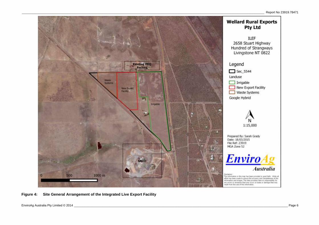
Figure 4: Site General Arrangement of the Integrated Live Export Facility
_________________________________________________________________________________________ Report No 23919.78471
EnviroAg Australia Pty Limited © 2014 _______________________________________________________________________ Page 7
4. Legislative Requirements
4.1.1 Environmental Protection and Biodiversity Conservation Act 1999 (Commonwealth)
The Environmental Protection and Biodiversity Conservation Act (EPBC Act) requires any development that could
have a significant impact on the environment or matter of national significance to be referred to the Australian
Government Minister for the Environment for assessment. A search of the EPBC Act protected Matters Search Tool
was undertaken and is attached in Appendix A.
4.1.2 Planning Act (NT)
The Planning Act outlines the requirements of development applications and administers the Northern Territory
Planning Scheme. The application must address these requirements to allow adequate assessment by the Determining
Authority.
4.1.3 Northern Territory Planning Scheme (NTPS)
The NTPS zones the proposed development site as R-Rural; and outlines the objectives and allowable development
within the zone. The proposed development is noted as Intensive Animal Husbandry and is discretionary which means
development consent is required from the Department of Land Planning and the Environment before this development
can be undertaken on the land. The development application will be lodged with the Department of Lands Planning and
the Environment concurrently with this Notice of Intent.
5. Existing Geography
5.1 Landscape and Soils
The land drains from east to west, with elevation varying from 54 AHD to 24 AHD across the site. The gradient is
approximately 1.5% to 3%.
The site is located in the NT Van Diemen soils group. Within this zone the landscape is undulating to rolling hills and
rises with mostly poorly developed, shallow and gravelly Kandosols, though Tenosols dominate the southern half of the
zone. The property is in the land units 3b.1 (NTGov:2015). The unit distribution is shown in the diagram below. It
covers the majority of the site.

_________________________________________________________________________________________ Report No 23919.78471
EnviroAg Australia Pty Limited © 2014 _______________________________________________________________________ Page 8
Figure 5 Land Unit of the Site (Blue Boundary) (NT Gov – NR Maps:2015)
Land Unit 3b is characterised by flat to very gently undulating upland surfaces, with gradient of 0.5 to 2.5%. Soils are
generally moderately deep to deep gravelly yellow massive earths usually overlying friable weathered material and
minor red massive earths, grading through the soil profile to sandy loam to sandy clay loam and light clay at depth.
Soils are well drained. Thus the soils are typical of Kandasols associated with the wet tropics.
5.1.1 Adjoining Landuse
Adjoining properties are utilised for grazing, cropping and pasture on rotation, with rail corridor on the south western
boundary of the proposed development site.
5.2 Geology
The Kandasol soils overly a sedimentary geology. The Kandasols contain varying amounts of clay. Clays are generally
shallow on the upper slopes or exposed hill crests; these are the likely recharge areas.
5.3 Hydrology
The site has no creeks and sites at the top of a watershed. Water runs off to the west. The site does not flood. Low
lying areas in the north east corner of the property, where it is lowest, and proximate to the railway line are flat and
become inundated with runoff from upslope.
Areas to the east of Stuart Highway are considered to be recharge areas. There is some connectivity between these
recharge areas, ground waters and downslope surface waters. Berri Creek gains water from the shallow groundwater
systems and it is groundwater that delivers water to this system during the dry season.
The chosen site is underlain by a considerable depth of clay and as such transmission of surface waters from the
property to the ground waters is at the best slow if not unlikely.
_________________________________________________________________________________________ Report No 23919.78471
EnviroAg Australia Pty Limited © 2014 _______________________________________________________________________ Page 9
5.4 Water Resources
5.4.1 Groundwater
The majority of the existing registered bores in the locality were drilled and constructed between 1995 and 2009 for
domestic and agricultural production purposes.
Soil drill logs where recorded for the majority of these bores in the immediate vicinity of the proposed development.
The majority of borehole/drill logs exhibited the following information:
topsoil to 0.5 – 1.0 metre depth;
sandy surface soil is underlain by sandy clay and clay layers to ~20 - 30 metres in;
depth providing a barrier to the groundwater aquifer;
deeper layers generally included yellow and grey clay, red and grey shale; and
siltstone with gravelly seams.
Most bores were drilled to depths ranging from 60 – 100 metres with standing water levels of 6 – 13 metres below
ground level. Yields were mostly sufficient for domestic and production bores ranging between 0.5 – 5 litres/second.
The main water bearing zones are recorded as being from approximately 27 – 95 metres in depth.
5.4.2 Surface Water
There are no major surface waters flowing across the site.
5.5 Flora
The site has been cleared and developed. Few trees remain on the site. Some exotic trees have been planted proximate
to the existing residence.
The vast majority of the property has been cultivated and sown to improved pasture species; Jarra and Tulla grasses as
shown in Figure 6 below.
A desktop search of the relevant databases was undertaken and the results are shown in the table below:
Table 2: Desktop Threatened Flora Search Results
Scientific Name Common Name Status Governing Body Comments
Atalaya brevialata - Critically
Endangered EPBC
Species or species
habitat may occur
within area
Cycas armstrongii - Vulnerable NT Recorded in the
area
The listed species were not observed on the site during the site inspection. The current and historic cultivation and
pasture practices would limit natural species regeneration.

_________________________________________________________________________________________ Report No 23919.78471
EnviroAg Australia Pty Limited © 2014 ______________________________________________________________________ Page 10
Figure 6: Pasture and Cultivation on "Livingstone Valley"
Figure 7: Wellard Livingstone Site Vegetation Map
_________________________________________________________________________________________ Report No 23919.78471
EnviroAg Australia Pty Limited © 2014 ______________________________________________________________________ Page 11
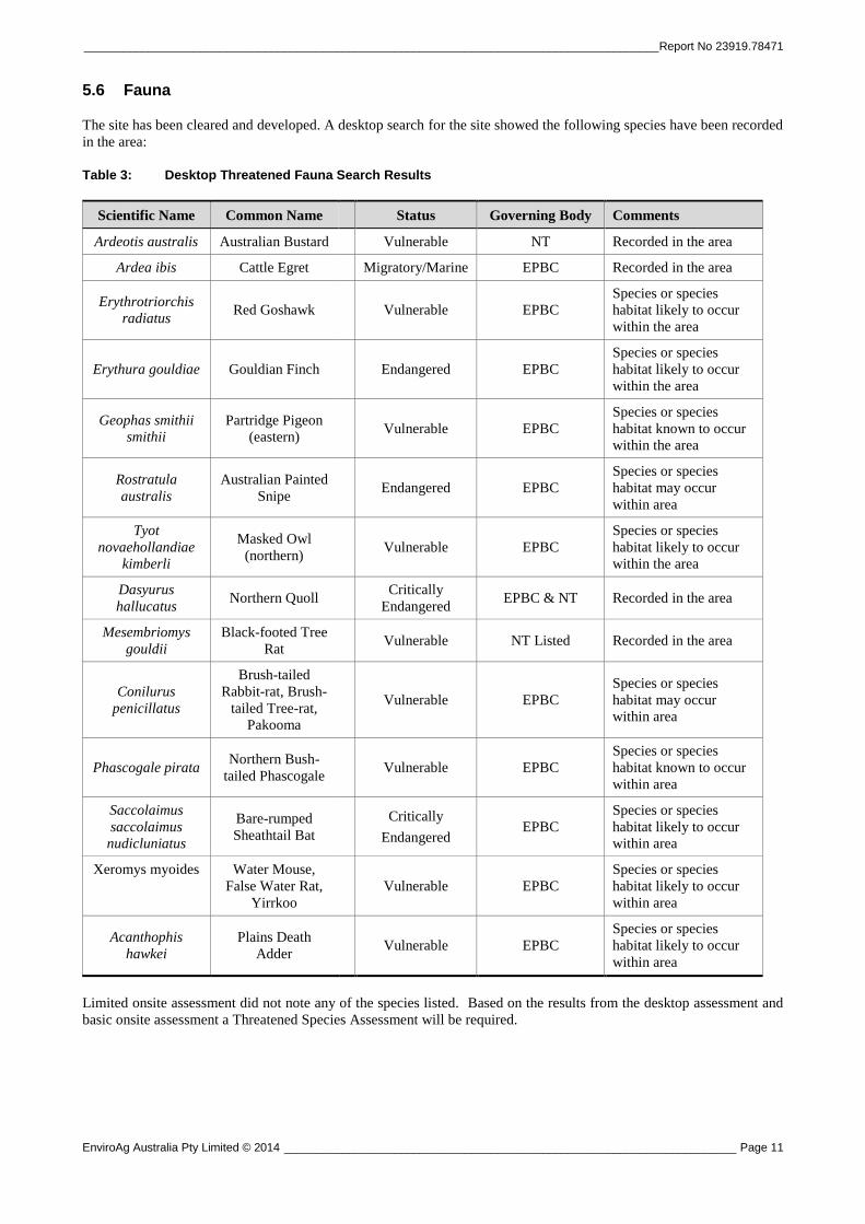
5.6 Fauna
The site has been cleared and developed. A desktop search for the site showed the following species have been recorded
in the area:
Table 3: Desktop Threatened Fauna Search Results
Scientific Name Common Name Status Governing Body Comments
Ardeotis australis Australian Bustard Vulnerable NT Recorded in the area
Ardea ibis Cattle Egret Migratory/Marine EPBC Recorded in the area
Erythrotriorchis
radiatus Red Goshawk Vulnerable EPBC
Species or species
habitat likely to occur
within the area
Erythura gouldiae Gouldian Finch Endangered EPBC
Species or species
habitat likely to occur
within the area
Geophas smithii
smithii
Partridge Pigeon
(eastern) Vulnerable EPBC
Species or species
habitat known to occur
within the area
Rostratula
australis
Australian Painted
Snipe Endangered EPBC
Species or species
habitat may occur
within area
Tyot
novaehollandiae
kimberli
Masked Owl
(northern) Vulnerable EPBC
Species or species
habitat likely to occur
within the area
Dasyurus
hallucatus Northern Quoll
Critically
Endangered EPBC & NT Recorded in the area
Mesembriomys
gouldii
Black-footed Tree
Rat Vulnerable NT Listed Recorded in the area
Conilurus
penicillatus
Brush-tailed
Rabbit-rat, Brush-
tailed Tree-rat,
Pakooma
Vulnerable EPBC
Species or species
habitat may occur
within area
Phascogale pirata Northern Bush-
tailed Phascogale Vulnerable EPBC
Species or species
habitat known to occur
within area
Saccolaimus
saccolaimus
nudicluniatus
Bare-rumped
Sheathtail Bat
Critically
Endangered EPBC
Species or species
habitat likely to occur
within area
Xeromys myoides Water Mouse,
False Water Rat,
Yirrkoo
Vulnerable EPBC
Species or species
habitat likely to occur
within area
Acanthophis
hawkei
Plains Death
Adder Vulnerable EPBC
Species or species
habitat likely to occur
within area
Limited onsite assessment did not note any of the species listed. Based on the results from the desktop assessment and
basic onsite assessment a Threatened Species Assessment will be required.

_________________________________________________________________________________________ Report No 23919.78471
EnviroAg Australia Pty Limited © 2014 ______________________________________________________________________ Page 12
6. Environmental Risk Assessment, Management and Monitoring
6.1 Environmental Risk Assessment
The risks associated with construction of the development and associated environmental impacts are very well known.
A Construction Environmental Management Plan (CEMP) will be developed. It will be developed by the successful
bidder for the tender of the construction of the facilities, and only upon completion and acceptance of the detail design
by Wellard’s. The CEMP will be submitted for approval by Wellard’s and the NT Government before construction
commences.
The selected site, general layout and design will all aim to minimise operational environmental impacts. Table 1 below
sets out the (preliminary) risk assessment and the likely residual risk for the identified key environmental factors. The
risk assessment uses a standard 5 by 5 risk assessment matrix.
The application of good mitigation practices renders most high risk activities to Low or Medium risks. Management
and monitoring measures will be applied for High and Medium risks only. Standard Operating Procedures (SOPs) and
Work Instructions (WI’s) will be used to all control risks.
6.2 Environmental Management
The facility will be operated under a quality, environmental and animal welfare management system. The quality
management systems will be focused on risk management across all facets on the business and the facility.
The environmental management will be set out in an “Operational” Environmental Management Plan. The OEMP will
include the following management plans;
(i) Environmental Monitoring Plan
(ii) Waste Management Plan
(iii) Irrigation (Waste Water) Management Plan
(iv) Weed Management Plan
(v) Pest Management Plan
(vi) Traffic Management Plan
Each management plan will set out work instructions (WI) for implementation of key tasks.
6.3 Environmental Monitoring
It is expected that, based on the current risk assessment; the proposed facility will monitor the following community and
physical factors.
The facility will maintain a complaints register. All “viable” community complaints will be investigated
and the register will contain the findings of the investigation.
Surface waters will be monitored by sampling of any spill from the holding pond or irrigation tailwater
pond should they occur.
Piezometers will be placed down slope of the facility to monitor (shallow) groundwater quality.
The amount of groundwater extracted for agricultural and stock and domestic use will be metered and
recorded.
The amount of compost sold / transported off site will be recorded
The tonnage of hay / fodder harvested from the site will be determined each year so as to determine the
nutrient recovery
Annual soil sampling will be undertaken in the waste water irrigation area to determine soil health and
monitor for any nutrient build ups that may pose a threat as a nutrient loss below the root zone.
It is expected that monitoring frequencies will vary from daily checks through to annual sampling of soils for
agronomic and environmental purposes.

________________________________________________________________________________________________________________________________________________ Report No 23919.78471
EnviroAg Australia Pty Limited © 2014 ______________________________________________________________________________________________________________________________ Page 13
Table 4: (Preliminary) Risk Assessment of Proposed Development and Related Environmental Factors
Hazard Frequency Severity Risk Mitigation Resultant Frequency
Resultant Severity
Residual Risk
Monitoring
Odour Nuisance Possible Significant High
Complaints phone number
Investigation system in place
Manure management
Dewater holding ponds
Possible Moderate Medium
Daily check
Weekly “check in” with receptors
Community complaint register
Dust Nuisance Likely Minor Medium
Managed stocking density
Watering of roads Possible Minor Low
Daily check
Community complaint register
Dust from internal roads Very Likely Minor Medium
Road aggregate selection
Dust suppressant
Road watering
Asphalt
Low vehicle speeds
Unlikely Low Low
Daily check
Contamination of Surface Waters
(Spill from Holding pond)
Unlikely Significant Medium
Pond sized to capture rainfall runoff
Significant irrigation pump capacity Unlikely Moderate Low
Holding pond depth level (available capacity)
Contamination of Ground waters below lined pens, drains, sed basin, holding ponds.
Unlikely Significant Medium-High
Clay lining
Armouring
Regular inspection Unlikely Moderate Medium
Measuring and testing of groundwaters in piezometers
Contamination of Groundwaters below irrigable areas
Possible Significant Medium-High
Treatment of waste water
Low application rates
Nutrient uptake by crop
Nutrient removal by crop harvest
Unlikely Moderate Medium
Soil sampling and testing
Measuring and testing of groundwaters in piezometers
Degradation of land / soils Likely Significant Medium
Safe appln of nutrients and water
Nutrient recovery through hay and fodder production
Possible Significant Medium
Soil sampling and testing
Record fodder and hay prodn
Nutrient testing of hay and fodder

________________________________________________________________________________________________________________________________________________ Report No 23919.78471
EnviroAg Australia Pty Limited © 2014 ______________________________________________________________________________________________________________________________ Page 14
Application of lime / gypsum Nutrient budgets
Visual Amenity Very Likely Minor Medium
Position the facilities below the horizon (from Stuart Highway) Unlikely Minor Low
Community complain register
Traffic Very likely Significant Medium
Correct turn in
TMP, restricted hours of movement Possible Significant Medium
Community complain register
Pest nuisance Very likely Moderate Medium
Design and construction
Double fencing
Chemical treatment of stock Likely Low Low
Daily checks of traps
Weeds Likely Moderate Medium
Import weed free certified feeds
Daily property checks
Weed control Unlikely Moderate Low
Daily property checks
Recording of weed control

______________________________________________________________________________ Report No 23919.78471
EnviroAg Australia Pty Limited © 2015 _____________________________________________________________ Page 15
7. Proposed Assessment
The assessment of the development will focus on medium and high risks identified in the risk assessment.
Key physical assessments will include;
(i) Physical site survey – RTK survey of site and surrounds (Completed)
(ii) Soil Assessment (Geotechnical / Agronomic) – test pits and soil tests (Completed)
(iii) Geological (Groundwater supply / hydrogeology) – pilot hole (In Process)
Desktop assessments will include;
(a) Comprehensive layout design and concept design (Completed)
(b) Odour Assessment (based on the National Guidelines for Beef cattle Feedlots)
(c) Traffic Assessment
(d) Hydraulic and Nutrient budgets for waste water reuse areas
(e) Threatened Species Assessment
Items b, c, d & e will be the main focus of the Environmental Impact Assessment provided as part of the
application.
Community Consultation will include;
Liaison with Government Agencies (Council, and Territory)
Direct communications with immediate neighbours; letter drop and arranged meetings
Supply of a statement for public release (information pack)
Direct contact phone line
Web site based information on the project with monthly updates
EnviroAg Australia (on behalf of Wellard’s) and Wellard’s will attend a Development Assessment Forum to
present the proposed development and to seek guidance form the Northern Territory Government and its
agencies and other stakeholders.
______________________________________________________________________________ Report No 23919.78471
EnviroAg Australia Pty Limited © 2015 _____________________________________________________________ Page 16
8. Summary
The proposed development is located away from neighbour receptors and is well separated from them. It is
located next to an existing PEQ yard and neighbours the AA Co meat processing facility. The proposed
development is likely to supplement the existing “Santavan” PEQ yard. The development is a land-use that
is fits within the rural zoning and is proximate to similar land uses.
The development will apply known design principles. It is a modest development (total capacity of 5000
SCU’s and Feedmill) that will deliver, business, environmental, animal welfare and community benefits.
The design delivers a state of the art facility which will enable Wellard’s to well manage the facility, limit
environmental impact and exercise best practice management of animal health and welfare.

______________________________________________________________________________ Report No 23919.78471
EnviroAg Australia Pty Limited © 2015 _____________________________________________________________ Page 17
9. Appendices
Appendix A. EPBC Act Protected Matters Search Results A-1
Appendix B. Drawings & Design B-1

______________________________________________________________________________ Report No 23919.78471
EnviroAg Australia Pty Limited © 2015 ____________________________________________________________ Page A-1
Appendix A. EPBC Act Protected Matters Search Results
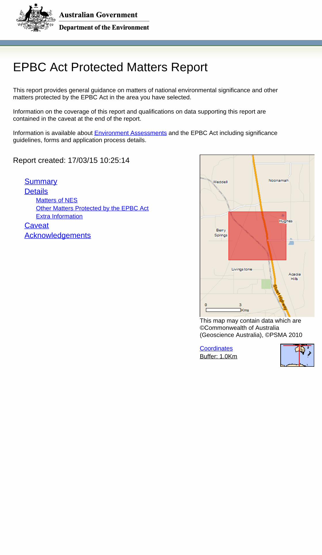
EPBC Act Protected Matters Report
This report provides general guidance on matters of national environmental significance and othermatters protected by the EPBC Act in the area you have selected.
Information on the coverage of this report and qualifications on data supporting this report arecontained in the caveat at the end of the report.
Information is available about Environment Assessments and the EPBC Act including significanceguidelines, forms and application process details.
Other Matters Protected by the EPBC Act
Acknowledgements
Buffer: 1.0Km
Matters of NES
Report created: 17/03/15 10:25:14
Coordinates
This map may contain data which are©Commonwealth of Australia(Geoscience Australia), ©PSMA 2010
CaveatExtra Information
DetailsSummary
Summary
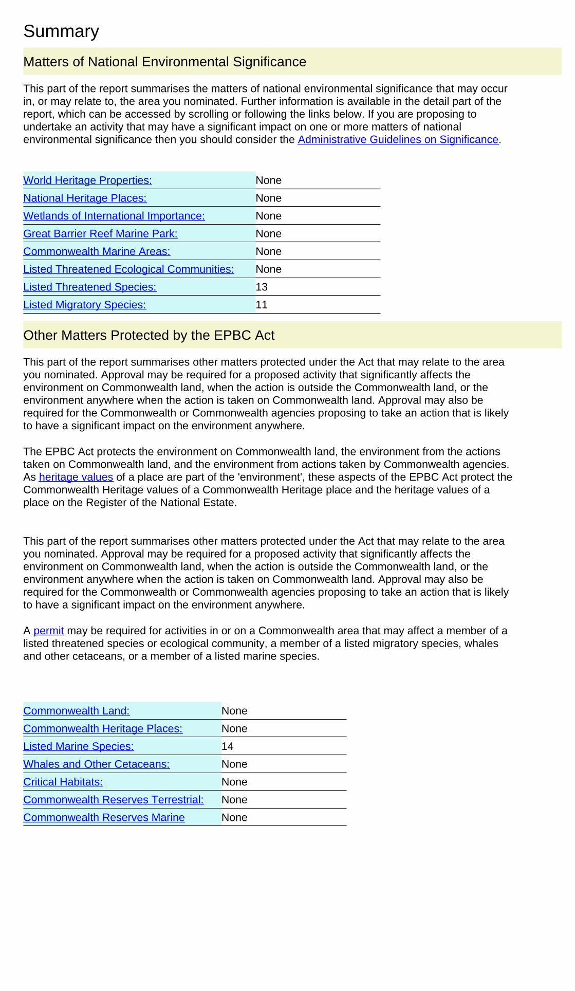
This part of the report summarises the matters of national environmental significance that may occurin, or may relate to, the area you nominated. Further information is available in the detail part of thereport, which can be accessed by scrolling or following the links below. If you are proposing toundertake an activity that may have a significant impact on one or more matters of nationalenvironmental significance then you should consider the Administrative Guidelines on Significance.
Matters of National Environmental Significance
Listed Threatened Ecological Communities:
Listed Migratory Species:
None
Great Barrier Reef Marine Park:
Wetlands of International Importance:
Listed Threatened Species:
None
13
None
None
National Heritage Places:
Commonwealth Marine Areas:
World Heritage Properties:
None
None
11
This part of the report summarises other matters protected under the Act that may relate to the areayou nominated. Approval may be required for a proposed activity that significantly affects theenvironment on Commonwealth land, when the action is outside the Commonwealth land, or theenvironment anywhere when the action is taken on Commonwealth land. Approval may also berequired for the Commonwealth or Commonwealth agencies proposing to take an action that is likelyto have a significant impact on the environment anywhere.
The EPBC Act protects the environment on Commonwealth land, the environment from the actionstaken on Commonwealth land, and the environment from actions taken by Commonwealth agencies.As heritage values of a place are part of the 'environment', these aspects of the EPBC Act protect theCommonwealth Heritage values of a Commonwealth Heritage place and the heritage values of aplace on the Register of the National Estate.
This part of the report summarises other matters protected under the Act that may relate to the areayou nominated. Approval may be required for a proposed activity that significantly affects theenvironment on Commonwealth land, when the action is outside the Commonwealth land, or theenvironment anywhere when the action is taken on Commonwealth land. Approval may also berequired for the Commonwealth or Commonwealth agencies proposing to take an action that is likelyto have a significant impact on the environment anywhere.
A permit may be required for activities in or on a Commonwealth area that may affect a member of alisted threatened species or ecological community, a member of a listed migratory species, whalesand other cetaceans, or a member of a listed marine species.
Other Matters Protected by the EPBC Act
None
None
None
Listed Marine Species:
Whales and Other Cetaceans:
14
Commonwealth Heritage Places:
None
None
Critical Habitats:
Commonwealth Land:
Commonwealth Reserves Terrestrial:
NoneCommonwealth Reserves Marine
Details
Listed Threatened Species [ Resource Information ]Name Status Type of PresenceBirds
Red Goshawk [942] Vulnerable Species or specieshabitat likely to occurwithin area
Erythrotriorchis radiatus
Gouldian Finch [413] Endangered Species or specieshabitat likely to occurwithin area
Erythrura gouldiae
Partridge Pigeon (eastern) [64441] Vulnerable Species or specieshabitat known to occurwithin area
Geophaps smithii smithii
Australian Painted Snipe [77037] Endangered Species or specieshabitat may occur withinarea
Rostratula australis
Masked Owl (northern) [26048] Vulnerable Species or specieshabitat likely to occurwithin area
Tyto novaehollandiae kimberli
Mammals
Brush-tailed Rabbit-rat, Brush-tailed Tree-rat,Pakooma [132]
Vulnerable Species or specieshabitat may occur withinarea
Conilurus penicillatus
Northern Quoll [331] Endangered Species or specieshabitat known to occurwithin area
Dasyurus hallucatus
Northern Brush-tailed Phascogale [82954] Vulnerable Species or specieshabitat likely to occurwithin area
Phascogale pirata
Bare-rumped Sheathtail Bat [66889] Critically Endangered Species or specieshabitat likely to occurwithin area
Saccolaimus saccolaimus nudicluniatus
Matters of National Environmental Significance
This part of the report provides information that may also be relevant to the area you have nominated.
Extra Information
Regional Forest Agreements:
23
Place on the RNE:
None
None
Invasive Species:
None
Nationally Important Wetlands:
State and Territory Reserves:
1
Key Ecological Features (Marine) None

Name Status Type of Presence
Water Mouse, False Water Rat, Yirrkoo [66] Vulnerable Species or specieshabitat likely to occurwithin area
Xeromys myoides
Plants
[86125] Critically Endangered Species or specieshabitat may occur withinarea
Atalaya brevialata
Reptiles
Plains Death Adder [83821] Vulnerable Species or specieshabitat known to occurwithin area
Acanthophis hawkei
Sharks
Largetooth Sawfish, Freshwater Sawfish, RiverSawfish, Leichhardt's Sawfish, Northern Sawfish[60756]
Vulnerable Species or specieshabitat likely to occurwithin area
Pristis pristis
Listed Migratory Species [ Resource Information ]* Species is listed under a different scientific name on the EPBC Act - Threatened Species list.Name Threatened Type of PresenceMigratory Marine Birds
Fork-tailed Swift [678] Species or specieshabitat likely to occurwithin area
Apus pacificus
Migratory Marine Species
Salt-water Crocodile, Estuarine Crocodile [1774] Species or specieshabitat likely to occurwithin area
Crocodylus porosus
Migratory Terrestrial Species
White-bellied Sea-Eagle [943] Species or specieshabitat likely to occurwithin area
Haliaeetus leucogaster
Barn Swallow [662] Species or specieshabitat may occur withinarea
Hirundo rustica
Rainbow Bee-eater [670] Species or specieshabitat may occur withinarea
Merops ornatus
Rufous Fantail [592] Species or specieshabitat likely to occurwithin area
Rhipidura rufifrons
Migratory Wetlands Species
Great Egret, White Egret [59541] Species or specieshabitat likely to occurwithin area
Ardea alba
Cattle Egret [59542] Species or specieshabitat likely to occurwithin area
Ardea ibis
Oriental Plover, Oriental Dotterel [882] Species or specieshabitat may occur withinarea
Charadrius veredus
Oriental Pratincole [840] Species or specieshabitat may occur withinarea
Glareola maldivarum
Painted Snipe [889] Endangered* Species or specieshabitat may occur withinarea
Rostratula benghalensis (sensu lato)

Listed Marine Species [ Resource Information ]* Species is listed under a different scientific name on the EPBC Act - Threatened Species list.Name Threatened Type of PresenceBirds
Magpie Goose [978] Species or specieshabitat may occur withinarea
Anseranas semipalmata
Fork-tailed Swift [678] Species or specieshabitat likely to occurwithin area
Apus pacificus
Great Egret, White Egret [59541] Species or specieshabitat likely to occurwithin area
Ardea alba
Cattle Egret [59542] Species or specieshabitat likely to occurwithin area
Ardea ibis
Oriental Plover, Oriental Dotterel [882] Species or specieshabitat may occur withinarea
Charadrius veredus
Oriental Pratincole [840] Species or specieshabitat may occur withinarea
Glareola maldivarum
White-bellied Sea-Eagle [943] Species or specieshabitat likely to occurwithin area
Haliaeetus leucogaster
Barn Swallow [662] Species or specieshabitat may occur withinarea
Hirundo rustica
Rainbow Bee-eater [670] Species or specieshabitat may occur withinarea
Merops ornatus
Osprey [952] Species or specieshabitat may occur withinarea
Pandion haliaetus
Rufous Fantail [592] Species or specieshabitat likely to occurwithin area
Rhipidura rufifrons
Painted Snipe [889] Endangered* Species or specieshabitat may occur withinarea
Rostratula benghalensis (sensu lato)
Reptiles
Freshwater Crocodile, Johnston's Crocodile,Johnston's River Crocodile [1773]
Species or specieshabitat may occur withinarea
Crocodylus johnstoni
Salt-water Crocodile, Estuarine Crocodile [1774] Species or specieshabitat likely to occurwithin area
Crocodylus porosus
Other Matters Protected by the EPBC Act
Extra Information
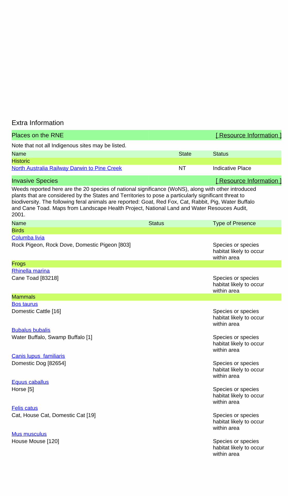
Places on the RNE [ Resource Information ]
Note that not all Indigenous sites may be listed.
Name StatusStateHistoric
Indicative PlaceNorth Australia Railway Darwin to Pine Creek NT
Invasive Species [ Resource Information ]Weeds reported here are the 20 species of national significance (WoNS), along with other introducedplants that are considered by the States and Territories to pose a particularly significant threat tobiodiversity. The following feral animals are reported: Goat, Red Fox, Cat, Rabbit, Pig, Water Buffaloand Cane Toad. Maps from Landscape Health Project, National Land and Water Resouces Audit,2001.
Name Status Type of PresenceBirds
Rock Pigeon, Rock Dove, Domestic Pigeon [803] Species or specieshabitat likely to occurwithin area
Columba livia
Frogs
Cane Toad [83218] Species or specieshabitat likely to occurwithin area
Rhinella marina
Mammals
Domestic Cattle [16] Species or specieshabitat likely to occurwithin area
Bos taurus
Water Buffalo, Swamp Buffalo [1] Species or specieshabitat likely to occurwithin area
Bubalus bubalis
Domestic Dog [82654] Species or specieshabitat likely to occurwithin area
Canis lupus familiaris
Horse [5] Species or specieshabitat likely to occurwithin area
Equus caballus
Cat, House Cat, Domestic Cat [19] Species or specieshabitat likely to occurwithin area
Felis catus
House Mouse [120] Species or specieshabitat likely to occurwithin area
Mus musculus
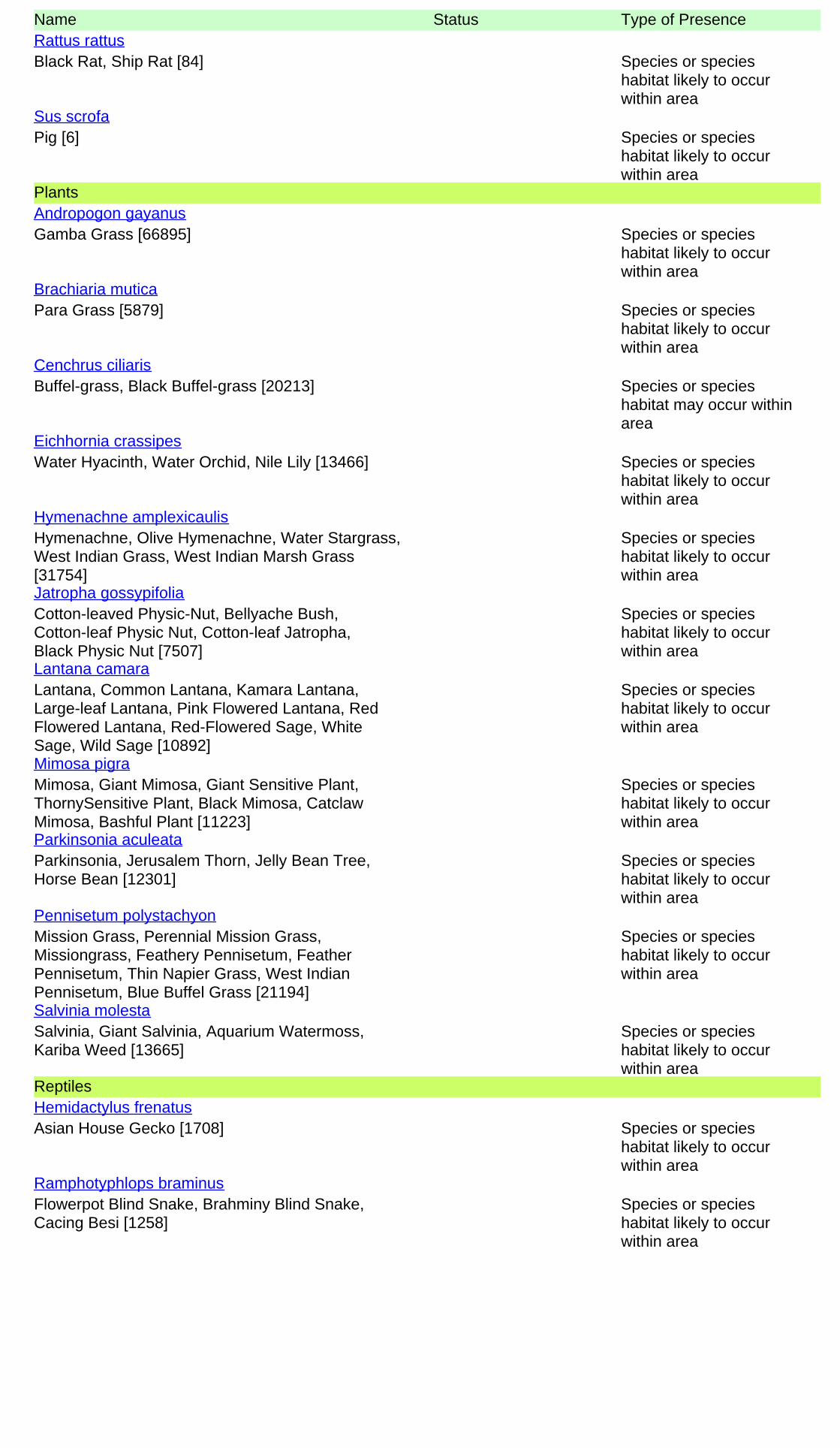
Name Status Type of Presence
Black Rat, Ship Rat [84] Species or specieshabitat likely to occurwithin area
Rattus rattus
Pig [6] Species or specieshabitat likely to occurwithin area
Sus scrofa
Plants
Gamba Grass [66895] Species or specieshabitat likely to occurwithin area
Andropogon gayanus
Para Grass [5879] Species or specieshabitat likely to occurwithin area
Brachiaria mutica
Buffel-grass, Black Buffel-grass [20213] Species or specieshabitat may occur withinarea
Cenchrus ciliaris
Water Hyacinth, Water Orchid, Nile Lily [13466] Species or specieshabitat likely to occurwithin area
Eichhornia crassipes
Hymenachne, Olive Hymenachne, Water Stargrass,West Indian Grass, West Indian Marsh Grass[31754]
Species or specieshabitat likely to occurwithin area
Hymenachne amplexicaulis
Cotton-leaved Physic-Nut, Bellyache Bush,Cotton-leaf Physic Nut, Cotton-leaf Jatropha,Black Physic Nut [7507]
Species or specieshabitat likely to occurwithin area
Jatropha gossypifolia
Lantana, Common Lantana, Kamara Lantana,Large-leaf Lantana, Pink Flowered Lantana, RedFlowered Lantana, Red-Flowered Sage, WhiteSage, Wild Sage [10892]
Species or specieshabitat likely to occurwithin area
Lantana camara
Mimosa, Giant Mimosa, Giant Sensitive Plant,ThornySensitive Plant, Black Mimosa, CatclawMimosa, Bashful Plant [11223]
Species or specieshabitat likely to occurwithin area
Mimosa pigra
Parkinsonia, Jerusalem Thorn, Jelly Bean Tree,Horse Bean [12301]
Species or specieshabitat likely to occurwithin area
Parkinsonia aculeata
Mission Grass, Perennial Mission Grass,Missiongrass, Feathery Pennisetum, FeatherPennisetum, Thin Napier Grass, West IndianPennisetum, Blue Buffel Grass [21194]
Species or specieshabitat likely to occurwithin area
Pennisetum polystachyon
Salvinia, Giant Salvinia, Aquarium Watermoss,Kariba Weed [13665]
Species or specieshabitat likely to occurwithin area
Salvinia molesta
Reptiles
Asian House Gecko [1708] Species or specieshabitat likely to occurwithin area
Hemidactylus frenatus
Flowerpot Blind Snake, Brahminy Blind Snake,Cacing Besi [1258]
Species or specieshabitat likely to occurwithin area
Ramphotyphlops braminus

-12.67888 131.05532,-12.67888 131.10041,-12.71608 131.10041,-12.71608 131.05532,-12.67888 131.05532
Coordinates
- non-threatened seabirds which have only been mapped for recorded breeding sites
- migratory species that are very widespread, vagrant, or only occur in small numbers
- some species and ecological communities that have only recently been listed
Not all species listed under the EPBC Act have been mapped (see below) and therefore a report is a generalguide only. Where available data supports mapping, the type of presence that can be determined from thedata is indicated in general terms. People using this information in making a referral may need to considerthe qualifications below and may need to seek and consider other information sources.
For threatened ecological communities where the distribution is well known, maps are derived fromrecovery plans, State vegetation maps, remote sensing imagery and other sources. Where threatenedecological community distributions are less well known, existing vegetation maps and point location dataare used to produce indicative distribution maps.
- seals which have only been mapped for breeding sites near the Australian continentSuch breeding sites may be important for the protection of the Commonwealth Marine environment.
For species where the distributions are well known, maps are digitised from sources such as recovery plansand detailed habitat studies. Where appropriate, core breeding, foraging and roosting areas are indicatedunder 'type of presence'. For species whose distributions are less well known, point locations are collatedfrom government wildlife authorities, museums, and non-government organisations; bioclimaticdistribution models are generated and these validated by experts. In some cases, the distribution maps arebased solely on expert knowledge.
The information presented in this report has been provided by a range of data sources as acknowledged atthe end of the report.
Caveat
- migratory and
The following species and ecological communities have not been mapped and do not appear in reportsproduced from this database:
- marine
This report is designed to assist in identifying the locations of places which may be relevant in determiningobligations under the Environment Protection and Biodiversity Conservation Act 1999. It holds mappedlocations of World Heritage and Register of National Estate properties, Wetlands of InternationalImportance, Commonwealth and State/Territory reserves, listed threatened, migratory and marine speciesand listed threatened ecological communities. Mapping of Commonwealth land is not complete at thisstage. Maps have been collated from a range of sources at various resolutions.
- threatened species listed as extinct or considered as vagrants
- some terrestrial species that overfly the Commonwealth marine area
The following groups have been mapped, but may not cover the complete distribution of the species:
Only selected species covered by the following provisions of the EPBC Act have been mapped:
-Department of the Environment, Climate Change, Energy and Water-Birds Australia-Australian Bird and Bat Banding Scheme
-Department of Environment and Conservation, Western Australia
Acknowledgements
-Department of Environment, Climate Change and Water, New South Wales
-Department of Primary Industries, Parks, Water and Environment, Tasmania
-Parks and Wildlife Service NT, NT Dept of Natural Resources, Environment and the Arts-Environmental and Resource Management, Queensland
-Department of Sustainability and Environment, Victoria
-Australian National Wildlife Collection
-Department of Environment and Natural Resources, South Australia
This database has been compiled from a range of data sources. The department acknowledges thefollowing custodians who have contributed valuable data and advice:
-Australian Museum
-National Herbarium of NSW
-State Forests of NSW-Australian Government, Department of Defence
-State Herbarium of South Australia
The Department is extremely grateful to the many organisations and individuals who providedexpert advice and information on numerous draft distributions.
-Natural history museums of Australia
-Queensland Museum
-Australian National Herbarium, Atherton and Canberra
-Royal Botanic Gardens and National Herbarium of Victoria
-Geoscience Australia
-Ocean Biogeographic Information System
-Online Zoological Collections of Australian Museums-Queensland Herbarium
-Western Australian Herbarium
-Tasmanian Herbarium
-Northern Territory Herbarium
-SA Museum
-Museum Victoria
-University of New England
-CSIRO-Other groups and individuals
© Commonwealth of Australia
+61 2 6274 1111
Canberra ACT 2601 Australia
GPO Box 787
Department of the Environment
Please feel free to provide feedback via the Contact Us page.

______________________________________________________________________________ Report No 23919.78471
EnviroAg Australia Pty Limited © 2015 ____________________________________________________________ Page B-1
Appendix B. Drawings & Design
