insular visions: cartographic imagery and the spanish-american war
TRANSCRIPT

INSULAR VISIONS: CARTOGRAPHIC I~KAGERY AND TELE SPANISH-AERICAN W m
RAYMOND B. CRAIB AND D. GRAHAM BURNETT
his year, 1998, marks the centennial of the Spanish-American War or, as T Secretary of State John Hay called it, “that splendid little war.” The war’s events have long since evaporated from popular memory, leaving only a few images such as Teddy Roosevelt rampaging up San Juan Hill or the cry of “Remember the Maine!,” a U.S. battleship sunk in Havana harbor. For the United States, however, the 113-day confrontation marked an epochal shift in the national identity. U.S. forces sent a European power skittering for cover and acquired for the United States the widely separated territories of Puerto Rico, the Philippines, and Cuba. An enthusiastic jingoism, fed by political rhetoric and strident journalism, recast the United States as an ascending imperial force.
This photo essay examines American imperial aspirations during and after the Spanish-American War through the maps and geographic imagery that helped con- struct the popular conception of the “American empire.” Our aim is to show how images of the once-Spanish possessions were produced and to explore the ways in which the Insular Territories acquired in the wake of the conflict came into the U.S. popular imagination. A newly imperial power demanded a colonial empire that could be presented on paper for domestic browsing; this meant putting these places on the map. An inquisitive public, an expansion-minded government, and an eager private sector all demanded visual instruments to domesticate and incorporate the foreign. Maps dramatized the country’s new imperial stature, and fixed the new acquisitions on the pages of atlases and on the expanding fields of U.S. territorial hegemony.
Although the most immediate images were of Cuba, Puerto Rico, and the Philippines, expansionist U.S. policies had nibbled away at the once vast Spanish acquisitions in the New World for nearly a century. As early as 1819, the United States had forced Spain to cede Florida, while the proclamation of the Monroe Doctrine in December 1823 left little doubt as to U.S. hemispheric ambitions. Indeed, the principal author of the Monroe Doctrine, John Quincy Adams, averred
Raymond B. Craib is a Ph.D. candidate in Latin American History at Yale University; D. Graham Burnett is a Mellon Fellow in History at Columbia Urziversity and a member ofthe Society of Fellows in the Humanities. The authors curated an exhibit at Yale University, March-May 1998, entitled Insular Visions 1898: The U.S. Imperial Imagination in Image and Text.

102 THE HISTORIAN
that Cuba and Puerto Rico were “natural appendages to the North American conti- nent.”’ In asserting a “ripe apple” policy, which assumed that Spanish possessions in the Caribbean would fall naturally into the orbit of the United States once the right conditions prevailed, Adams revealed his firm conviction that the annexation of Cuba and Puerto Rico would be both indispensable and inevitable, a conviction born of a geographic imaginary that equated proximity with destiny.
In 1834, a European traveler in the service of the Spanish government, one Colonel Flinter, pronounced with a prescient speculation that the “safety [and] sal- vation of the islands of Cuba and Puerto Rico, depend,” among other things, “upon the cultivation of a good understanding with the United States of America.”2 This conclusion was based in part upon a recognition of the changing political, eco- nomic, and intellectual order of the nineteenth century. “Comparative Hemispheres,” Figure 1, representing the apex and nadir of Spanish influence in the Americas, emphasizes the point and shows that by 1898, Spain’s base of operations in the Caribbean has been reduced to a pair of lonely outposts.
Cartographic determinism permeated nineteenth-century thought. Referring to the acquisition of Texas, for example, businessman and Democrat John O’Sullivan stated in 1844 that anyone “who cast a glance over the map of North America” could see that Texas was “a huge fragment, artificially broken off” from the continent to which it naturally be l~nged .~
As the map of Cuba shown in Figure 2 dramatically demonstrates, geographic determination punctuated the styles of cartographic representation of the Caribbean, suggesting Cuba would inevitably be subsumed into the U.S.. The text in the lower right corner emphasizes the multiple links between the “Gem of the Antilles” and Florida’s peninsula, the southern extremity of the US., which reaches down through the frame of the map, intimating both proximity and imminence. While the text expands on the importance of the bonds forged by investment and education, geography remains the essential link; the authors claim the U.S. has shown unusual restraint in forgoing the opportunity to annex the island:
It may be taken for granted that any other nation on the Globe would have long ago possessed itself of so rich an island as Cuba, lying within a hundred miles of its own doors.
‘Charles Sellers, The Market Revolution: Jacksonian America, 1815-1846 (Oxford and New York,
’George Dawson Flinter, An Account ofthe Present State ofthe Island ofPuerto Rico (London, 1834), 372.
’Democratic Review, April 1844, quoted in Anders Stephanson, Manifest Destiny: American Expansion
1991), 100.
and the Empire ofRight (New York, 1995). 43.

INSULAR VISIONS: CARTOGRAPHIC IMAGERY AND THE SPANISH-AMERICAN WAR 103
Figure 2. Mapa de la Isla de Cuba (1897). This map details Spanish outposts on Cuba as discrete points held by Spain in contrast to most of the rest of the countrx which is depicted as already liberated, emphasizing the successes of the Cuban revolutionary forces.
The proximity of the Spanish Caribbean to the U.S. mainland complicated U.S. foreign policy. While the United States supported independence movements throughout Latin America, it obstinately opposed independence for the Caribbean Spanish possessions. Not only did U.S. politicians view an independent Cuba as too weak to maintain independence from European power, they also feared that inde- pendence would mean the abolition of slavery, a move that would complicate an already precarious balance in U.S. political and economic life.
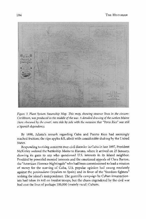
By the 1880s, U.S. investors were increasingly looking south. The major U.S. interests in the Caribbean were commercial. Over 90 percent of Cuba’s sugar pro- duction was exported to the United States in 1886, leading U.S. consul Ramon 0. Williams to state, “Cuba is already inside the commercial union of the United States. The whole commercial machinery of Cuba depends upon the sugar market of the United state^."^ This web of commercial interests is portrayed visually in the “Plant System Steamship Map” of 1889 reproduced in Figure 3, in which Cuba sits uncom- fortably amid the complex shipping lanes of commerce. The map suggests that, regardless of war, it would be business as usual for U.S. companies plying their trade in the Caribbean.
4Ramon 0. Williams to James N. Porter, December 28, 1886, cited in Louis A. Perez Jr., ed., Slaves, Sugar and Colonial Society: Travel Accounts of Cuba, 1801 -1899 (Wilmington, 1992), xvii.
1 04 THE HKIOKIAN
Figure 3. Plant System Steumship Map. This map, showing steamer lines in the circum- Caribbean, was produced in the middle uf’the war. A detailed drawing of the sunken Maine (here obscured by the cover) rests side by side with the notation that “Porto Rico” was still u Spunish dependency.
By 1898, Adams’s remark regarding Cuba and Puerto Rico had seemingly reached fruition; the ripe apples fell, albeit with considerable shaking by the United States.
Responding to rising concerns over civil disorder in Cuba in late 1897, President McKinley ordered the battleship Maine to Havana, where it arrived on 25 January, showing its guns to any who questioned U.S. interests in its island neighbor. Prodded by powerful monied interests and the emotional appeals of Clara Barton, the “American Florence Nightingale” who had been commissioned to lead a mission of mercy for the starving of Cuba, U.S. popular opinion had swung resolutely against the peninsulures (loyalists to Spain) and in favor of the “freedom fighters” seeking the island’s independence. The guerrilla campaign by Cuban insurrection- ists had taken its toll on loyalist troops, but the chaos engendered by the civil war had cost the lives of perhaps 100,000 (mainly rural) Cubans.

INSUIAR VISIONS: CARTOGM’HIC IMAGERY AND THE SPANISH-AMERICAN WAR 105
Figure 4. Rubber stamping of the Maine (detail from Figure 2). With the sinking of the Maine, existing maps immediately became out of date. Map publisher J. L. S. Smith solved the problem by marking the site of the explosion with a rubber stamp. Though Spanish agency was never established, no doubt is left as to the cause: “U.S.S. Maine Blown Up.”
When Charles D. Sigsbee, captain of the Maine, was jolted to his feet on the evening of 15 February 1898, he was standing on a sinking ship. A colossal explo- sion had ripped the Maine’s midships into a giant open lily of armor plate. As the ship listed, he called out the order to flood the magazines, but it was already too late; the Maine exploded and sank in Havana harbor carrying 252 of its 354 men and officers (see Figure 4).
Down with the Maine went Spanish-U.S. relations, and on 11 April, President McKinley asked Congress for a declaration of war, granted 11 days later. On 1 May 1898, the U.S. Pacific Squadron under Commodore George Dewey steamed into Manila Bay in the Philippine Islands and destroyed the Spanish fleet. Dewey’s vic- tory reportedly sent McKinley running to a map torn from an old geography
SStephanson, Manifest Destiny, 92.

106 THE HISTORIAN
Figure 5. Military Field Map. This military map of Cuba, prepared in the U.S. War Department’s Military Information Division, is one of eight sheets that together composed the entire island of Cuba at a scale of 1:250,000. Mounted on linen so that they could be folded and carried in the field by military personnel, the maps distinguished between differ- ent kinds of roads, pin-pointed warehouses and telegraph stations as well as shops and small farms, tracked railroad lines, and showed the boundaries and seats of municipal and judicial districts. This particular map shows the port and environs of Santiago de Cuba. The most intense fighting involving U.S. forces took place near Santiago, including the Rough Riders’ charge on San Juan Hill (located just southeast of Santiago).

INSULAR VISIONS: CARTOGRAPHIC IMAGERY AND THE SPANISH-hEKICAN WAK 107
Operations against Cuba began on 29 May, when the U.S. Navy blockaded the Spanish fleet in Santiago harbor. A week later, U.S. Marines landed at Guantanamo Bay, followed soon after by a force of some 16,000 men at Daiquiri. With naval and ground forces in place, the stage was set; on 1 July 1898 U.S. forces routed the Spanish in the battles of El Caney and San Juan Hill. The decisive naval victory of 3 July at Santiago led to the surrender of the Spanish garrison there two weeks later.
Maps were obviously crucial to military missions, both for use in the field and in the offices of the Secretary of War. They served as texts of record, where flags were distributed to mark controlled territories and the patterns of engagements were recorded for later review by superiors, and as a tool for calculating local movements (see Figure 5 ) . The systematic production and distribution of “standard” military- issue maps enhanced the sense that a rational and centralized command of forces in the field was possible. As one commentator noted:
The wires in the White House place the President in touch with all the departments represented in his Cabinet and joined to the wonderful web spun round the world, over which is wrought the mighty magic of telegraphy; and in the recent war the defense of our coast, and the offense of our ships and battalions in the Indies, East and West, the President was constantly in swift and sure communication with the front- and no word of his is found that did not command and cheer the advance and testify his courage and vigilance.6
The operation of this smoothly-functioning, centrally-regulated machine depended on accurate maps based on knowledge from shared, captured, and plagia- rized geographic and cartographic sources. The Adjutant General’s Office of the War Department frequently either copied Spanish maps or simply republished them, as with the maps of Puerto Rico and the Philippines shown in Figures 6 and 7 . At the same time, U.S. citizens overseas were warned to be suspicious of Spanish maps that they might find or appropriate, as duplicity was to be expected.’ Cartographic espi- onage counted for a great deal: the invasion of Puerto Rico by General Nelson A. Miles relied on the reconnaissance of one Lieutenant Henry L. Whitney, commis- sioned to reconnoiter the island of Puerto Rico clandestinely in preparation for the invasion. When Miles abandoned his planned landing in Fajardo, on the northeast corner of the island, and came ashore at Guanica (in the southwest) instead, it was in part on the strength of Whitney’s sketch maps and other information.
6Murat Halstead, Full Oficial History o f the War with Spain (n.p., 1899), 13.
’Thomas Campbell-Copeland, American Colonial Handbook; a ready reference book offacts and fig- ures, historical, geographical, and commercial, about Cuba, Puerto Rico, the Philippines, Hawaii, and Guam, 2d ed. (New York and London, 1899), 25.

108 THE HISTORIAN
Figure 6. Outline Map of Puerto Rico. Several clues suggest that the General Staff Map of Puerto Rico, from which this was copied, was itself copied at least in part from captured Spanish sources. Not only are the radii of visibility for the lighthouses given in Spanish, but in several places an ellipsis followed by a question mark indicate that a copyist was unable to decipher what was probably a manuscript source. Tracing of the islands standing of the southern shore is also incomplete: they appear as ghostly fragments of territory.
Changes in technology allowed the press to keep the public informed of the lat- est developments. Reporters listened carefully to telegraph reports and published war news sometimes even before events were reported in Washington. The popular press, particularly the “yellow journals” such as William Randolph Hearst’s Journal and Joseph Pulitzer’s World, escalated their sensationalist coverage as they com- peted for market share. As the author of a volume printed in 1898 wrote:
In no war that ever took place did the press go so expensively into the enterprise of reporting. . . . The sums of money spent in the newspaper enterprise were enormous.8
Reporters accompanied every troop movement, and their cables frequently out- paced the channels of military communication; the Secretary of War read the
RHalstead, Full Oficial History, 20,

INSULAR VISIONS: CARTOGRAPHIC IMAGERY AND THE SPANISH-AMERICAN WAR 109
Figure 7. Map of the Philippines. In 1899 and 1900, the same office that produced thepre- ceding map of Puerto Rico simply republished Claudio Montero y Gay’s Carta General del Archipelago Filipino (Madrid 1875) over-printed with new military cable lines and the divisions between US. military department boundaries.
papers carefully. The assiduous attentions of clamoring newsmen meant that no movement of U.S. forces went unreported. In fact, word of Lt. Whitney’s spy mis- sion made it to the papers before he made it to Puerto Rico, putting him in grave danger. Similarly, rumors of General Miles’s planned landing at Fajardo circulated widely in the popular press. To ensure secrecy, Miles did not even inform head- quarters of his decision to land at Guanica instead. The secretary of war learned of the switch only after it had happened, and then from a dispatch of the Associated Press!
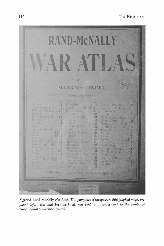
As U.S. readers followed the war in both daily newspapers and heavily illus- trated weeklies, demand for popular cartography grew tremendously. Atlas makers and newspapers alike responded in force. The Rand-McNally War Atlas reproduced in Figure 8 illustrates the speedy commercial capitalization on the stormy political events of April 1898. The House and the Senate were still debating the “Cuban
110 THE HISTORIAN
Figure 8. Rand-McNally War Atlas. This pamphlet of inexpensive lithographed maps, pre- pared before war had been declared, was sold as a supplement to the company’s Geographical Subscription Series.

INSULAR VISIONS: C A R T O G W H I C IMAGERY AND THE SPANISH-AMERICLW WAR 11 1
Figures 9 and 10. “The Question of the Hour.” This map has worn so poorly because it was a newspaper insert, not intended to be permanent. A close look reveals that the color litho- graphy has been poorly registered (meaning the color blocks drift outside the black outlines); the original paper is only slightly heavier than newsprint.

112 THE HISTORIAN
question” and war had yet to be declared as the staff cartographers at Rand- McNally worked furiously to prepare this volume.
Once the war began, newspapers became popular cartographers, producing maps as inserts. Inexpensive printing placed these new resources into the hands of a vast reading audience and kept U.S. citizens in contact with the unfolding events, so that every citizen could become an armchair strategist, plotting troop movements and naval battles on their parlor wall. The Question of the Hour map shown in Figures 9 and 10 was produced as a newspaper insert. The document sit- uates the destruction of the Maine in a global context, both by means of the nested maps on the recto and then by the world map and elaborate comparative statistics on the verso. The event, fixed in space by means of a red star on the har- bor map and time (“9:40 P.M., February lSth 1898”), was indeed, as the bold title suggests, the question of the moment. Readers were invited to peruse what amounted to a scorecard of the respective strengths of Spain and the United States, along with a brief sketch on the Revolutionary Government of Cuba. Statistics on the Philippines and Puerto Rico are also listed at the bottom of the left column, as are details on the ships and men available to the potential combatants.
Maps were also used to follow the course of the war, serving as visual accom- paniments to lead articles and as up-to-date teaching tools in the country’s class- rooms. The Evening Post map of the West Indies shown in Figure 1 1, for example, allowed readers to plot Admiral Sampson’s movements from “Cap Haitien” to Cienfuegos during the dramatic pursuit of the Spanish Fleet. Students absorbed history in the making through maps that presented key geographical stages of the unfolding military engagement, as can be seen in Figure 12. Thus the islands of Puerto Rico, Cuba, Guam, and the Philippines made their entrance into the popular U.S. consciousness through the military engagements and their associ- ated maps.
After the war, demand for information about the newly acquired territories grew exponentially. The postwar texts not only recalled the glorious exploits of U.S. soldiers but tried to provide the reading public with purportedly critical and reliable geographical information about the new possessions-their histories, peoples, and economies. Such works located the new territorial acquisitions within the broader trajectory of U.S. history and geography.
Publishers produced texts like Campbell-Copeland’s American Colonial Handbook, which was posed in a question and answer format fittingly entitled a “colonial catechism.” Not only would such books teach the reading public about the new lands, they would also provide “a bird’s-eye view of territory ceded or annexed to the United States during 1898, or at present in the safe-keeping of the United

INSULAR VISIONS: CARTOGRAPHIC IMAGERY AND THE SPANISH-AMERICAN WAR 1 13
Figure 11. The Evening Post map of the West Indies. This supplement to the Evening Post was published on the day of President McKinley’s Proclamation calling for 75,000 new vol- unteers. Less than two weeks before, Admiral Sampson had bombarded the fortifications of Sun Juan, Puerto Rico and then taken his fleet deeper into Caribbean waters seeking the Spanish fleet. Though unsuccessfil, he nevertheless managed to capture several Spanish merchant ships. U.S. newspapers crowed at the booty: more than $750,000. These announcements would have appeared in papers at the same time as this map.
States military and naval forces,” using the pervasive cartographic imagery of the day. Each chapter of the handbook is introduced by a map of the region under review, as shown in Figure 13. The combination of map, geographic litany, and ethnographic exegesis invited the public to take effective control of the new territo- ries and their peoples as objects for colonial consumption.
Memorializing texts, including hefty tomes of history, boys’ adventure stories, eulogizing ballads, and atlases, were used to bring the newly acquired territories
9Campbell-Copeland, preface to American Cotonial Handbook.

114 THE HISTORIAN
Figure 12. War with Spain including Battles on Sea and Land. A marginal note on this map reveals that it was prepared by the “McConnell School Supply Co., Philadelphia, PA.” for use in the classroom. The position of the United States, an inset in the upper right corner, makes this map somewhat unusual; the juxtaposition of the Cuba and the United States at such difierent scales must have proved confusing for students.
into the domestic world of the U.S. public. The Pictorial Atlas of the Spanish- American War shown in Figure 14, published in late 1898, is typical of the com- memorative volumes of the period. Noting that the conflict had brought “new regions within the range of our daily study,” the producers of the atlas packed it with maps (“SO complete, so accurate, so satisfactory, of so recent revision, and of such value in the newer era”) and illustrations “made by special artists who were present when the incidents depicted transpired.” Such volumes were often offered as special supplements to popular middle-class domestic periodicals like Farm and Fireside and Women’s Home Companion.’o
Interest in the United States’ new territorial acquisitions extended beyond the readers of popular weeklies and the yellow journalism. Intellectuals were quick to coalesce around an ascendant colonial bureaucracy, participating in a myriad of expeditions and producing numerous maps and volumes that were quickly filed into a burgeoning imperial archive. They also wrangled over the names of the new
’“See Trumbull White, Our New Possessions (n.p., 1899(?]), Gonzalo de Quesada, America’s Battle for Cuba’s Freedom (Chicago, 1898), Murat Halstead, The History of American Expansion and the Story ofOur New Possessions. The Spanish-American War and the Heroes of ’98 (n.p., 1898), Halstead, Full Official History (n.p.,1899); W. Nephew King, The Story ofthe War of 1898 (New York, 1898) and Harper’sPicturial History ofthe War with Spain (New York, 1899); Edward Stratemeyer, Under MacArthur in Luzun; or lust battles in the Pbilippines (Boston, 1930) and A Young Volunteer in Cuba; or fighting for the single stur (Boston, 1898); Horace Spencer Fiske, The Ballad ofManila Bay and Other Verses (Chicago, 1900).

INSULAR VISIONS: CARTOGRAPHIC IMAGERY AND THE SPANISH-AMERICAN WAR 115
Figure 13. The American Colonial Handbook, with map and introduction to Cuba. The handbook pictured here served as a ready reference guide for the histories, geographies, and economies of the new territories, including Cuba, Puerto Rico, the Philippines, Hawaii, and Guam. Each territory composed a chapter, opening with a map and a brief historical gloss
A V A C U ~ S L L
-* = Ls. m.-- 1 u%% b-* &- -fu;r i__ i, * *,_.".--*
Figure 14. Pictorial Atlas Illustrating the Spanish-American War. This atlas served the roles of both popular history and picture book. In addition to a timeline of the events of the conflict, the volume offered hagiographic images of serene U.S. naval oficers presiding over orderly and stylized bombardments. Maps made up less than halfof the visual content of the book.

116 THE HISTORIAN
Figure 15. Latest Map, Island of Porto Rico, New Territory, U.S.A. The text in the car- touche asserts: “Now that this lovely Island of Porto Rico has become part of the Great Republic, every citizen should possess a map of the new Territory.” The author of the cap- tion for this map made no effort to conceal his enthusiasm for the incorporation of the island into the Union as a state. Not only did the term “Territory” receive considerable emphasis, but the rhetoric of the caption portrays the island as more than a tropical paradise; the allu- sion to a “veritable Switzerland” invokes the image of rugged republicanism, civil order, cleanliness, and diligence, sentiments echoed by the reference to the “intelligence, culture and morality” of the inhabitants.
acquisitions, particularly that of Puerto Rico. In 1899, Robert T. Hill of the United States Geological Survey submitted a memorandum to the National Geographic magazine entitled “Porto Rico or Puerto Rico” in which he weighed in strongly behind “Porto Rico.” His reasoning relied in part upon claims derived from maps; he argued that the name ‘‘Port0 Rico” could be traced back through nearly 300 years of English and French cartography.”
While the various texts and maps often reflected upon the past, they also looked to the future. Public and politicians argued intensely over the position of the newly acquired territories in forms diverse as pamphlets and cartoons. In addition, a vibrant expatriate community thrived in the United States prior to and during the
“National Geographic Magazine, December 1899,516-17.
INSULAR VISIONS: CARTOGRAPHIC IMAGERY AND THE SPANISH-AMERICAN WAR 11 7
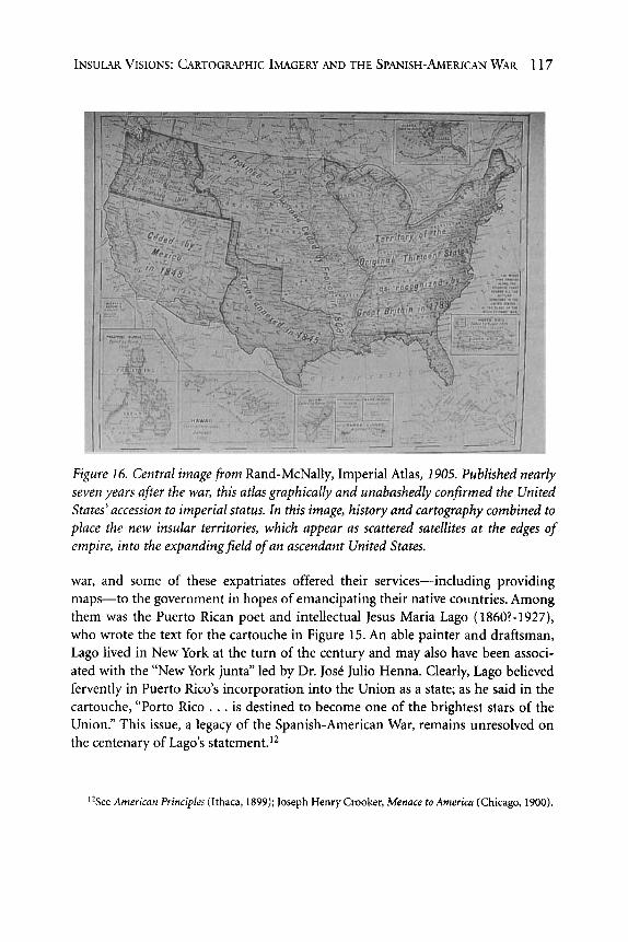
Figure 16. Central imagefiom Rand-McNally, Imperial Atlas, 1905. Published nearly seven years after the war, this atlas graphically and unabashedly confirmed the United States’ accession to imperial status. In this image, history and cartography combined to place the new insular territories, which appear as scattered satellites at the edges of empire, into the expandingfield of an ascendant United States.
war, and some of these expatriates offered their services-including providing maps-to the government in hopes of emancipating their native countries. Among them was the Puerto Rican poet and intellectual Jesus Maria Lago (18601-1927), who wrote the text for the cartouche in Figure 15. An able painter and draftsman, Lago lived in New York at the turn of the century and may also have been associ- ated with the “New York junta” led by Dr. JosC Julio Henna. Clearly, Lago believed fervently in Puerto Rico’s incorporation into the Union as a state; as he said in the cartouche, “Porto Rico . . . is destined to become one of the brightest stars of the Union.” This issue, a legacy of the Spanish-American War, remains unresolved on the centenary of Lago’s statement.12
‘*See American Principles (Ithaca, 1899); Joseph Henry Crooker, Menace to America (Chicago, 1900).

11s THE HISTORIAN
Publishers seized upon the spirit of patriotic destiny and produced atlases that folded the new acquisitions into a triumphant story of U.S. expansion even while the precise nature of how to incorporate the new states was uncertain. The setting of the sun on the “old world empires of Europe meant dawn for the nascent empire of the United States. The last map reproduced here, a 1905 map from Rand-McNallyS sig- nificantly titled Imperial Atlas, offers a fitting final image precisely because it illus- trates how cartographic imagery and the graphic display of historical information combined to create a visual argument. America’s “Manifest Destiny” is shown in the gradual and progressive westward expansion of the United States, a common feature of nineteenth-century popular histories. In the wake of the Spanish-American War, a set of inset maps depicting the insular acquisitions has been added. As satellite pos- sessions, these new territories reside at the margins of the continental United States-both on paper and in status-but they nevertheless belong “on the map”; they have been given their place in a cartographic pageant of accessions to the Great Republic.