inset map - planning
TRANSCRIPT
MELTO
N H
IGH
WA
Y
PLUMPTON ROAD
VERE COURT
SINCLAIRS ROAD
SARIC COURT
HU
ME D
RIVE
TAYLO
RS ROA
D
BEATTYS ROAD
CITY VISTA COURT
TARLETO
N RO
AD
KENN
EDY D
RIVE
1080 KORO
ROIT
PSP
gas easement
power easement
Pedestrian / cyclist connection across O
MR
Vehicle access to and across O
MR
Future possible extension to Sunbury
Road access into W
arrensbrook PSP1077
WA
RRENSBRO
OK
PSP
GREEN
WED
GE
ZON
E
1030 TAYLORS
HILL W
EST PSP
1079 ROCKBA
NK
NO
RTH PSP
SPECIAL U
SE ZO
NE
PLUMPTON ROAD
SARIC COURT
VERE COURT
CLARKE ROAD
MONAGHANS LANE
DEANSIDE DRIVE
GRAY COURT
TAYLO
RS ROA
DREED CO
URT
NEA
LE ROA
D
SINCLAIRS ROAD
WESTERN FREEW
AY
CITY VISTA COURT
CARO
LINE SPRIN
GS
MELBO
URNE-BALLARAT RAILWAY
gas easement
power lines easement
Vehicle access to and across O
MR
OUTER METROPOLITAN RING
Kororoit Creek
Kororoit Creek
1082 M
T. ATKINSO
N PSP
1030 TAYLOR
HILLS W
EST PSP1079 RO
CKBAN
K N
ORTH
PSP1078 PLU
MPTO
N PSP
1083 WA
RRAWEE PSP
HOPKINS ROAD
PSP 1080.2 (KORO
ROIT PA
RT 2) PRO
POSED
KORO
ROIT REG
ION
AL
PARK
R2 (TARLETO
N RO
AD
)
R1 (PLUMPTON ROAD)
R4 (SARIC COURT)
R3 (BEATTYS ROAD)
R5 (TAYLO
RS ROA
D)
12
3
4567
89
1011-R
11-E
12 - R12 - E
13 14 15
1617
1819
2021
22
2324
25
26
27
28
29
30
3132
33
34
3536
37
38
42
39 - E
39 - R
40
41
4344
4546
47 48
49
5051
52
53 54
55
14
9
8
6
5 2
3
10
1121
13 - R13 - E
24
25
15
16
17
1819
20
2627
66
65
6364
66a6768
69
7067a
9a
31a
8a
36 32 2829
3031
33
37
4041
42
38 34
35
4339
4546
4748
51 - R51 - E
50 49 44
52
51a
5354
55
56
57
5860
6159
R6
7
12
14
R9-ER9-R
R2 (VERE COURT)
R6 (DEANSIDE DRIVE)
R7 (GRAY COURT)R8 (NEA
LE ROA
D)
R5 (REED CO
URT)
R3 (SINCLAIRS ROAD)
R4 (MONAGHANS LANE)
CU-01
CU-01
CU-02
CU-02
CU-03
CU-03
CU-05
CU-05
CU-04
CU-04
CU-06
CU-06
CU-07
CU-07
CU-08
CU-08
PS-01PS-01
PS-02PS-02
PS-03PS-03
PS-04PS-04
PS-05PS-05
PS-06PS-06
PBR-02
PBR-03
PBR-04
BR-02
BR-03
BR-01
PBR-01
RD-01
RD-03
RD-02
IN-01
IN-01
RD-06
RD-07
RD-08
RD-04
RD-05
RD-09
RD-10
RD-11
RD-12
RD-13
RD-14
RD-15
RD-16
RD-17
RD-18
RD-19
RD-20
IN-04
IN-04
IN-03
IN-03
IN-02
IN-02
IN-05
IN-05
IN-06
IN-06
IN-07
IN-07
IN-08
IN-08
IN-09
IN-09
IN-10
IN-10
IN-11
IN-11
IN-12
IN-12
IN-13
IN-13
IN-14
IN-14
IN-15
IN-15
IN-16
IN-16
IN-17
IN-17
IN-18
IN-18
IN-19
IN-19
IN-20
IN-20
IN-21
IN-21
IN-23
IN-23
IN-22
IN-22
IN-24
IN-24
E-W RD
5
E-W RD
6
E-W RD
1
N-S RD 2
N-S RD 1
N-S RD 5
N-S RD 4
E-W RD
2E-W RD
4
E-W RD
3N-S RD 3
ICP boundary
road project
intersection project
bridge project
culvert project
pedestrian bridge
pedestrian signal
ICP project identi�cation number
bridge
pedestrian bridge
culvert
intersection
road
pedestrian signal
BRPBR
CUINRDPS
RD-07
Copyright, Victorian Planning Authority, 2017 The state of Victoria does not warrant the accuracy or completeness of information in this publication and any person using or relying upon such information does so on the basis that the State of Victoria shall bear no responsibility or liability whatsoever for any errors, faults, defects or omission in the information. Copyright, Victorian Planning Authority, 2017 The state of Victoria does not warrant the accuracy or completeness of information in this publication and any person using or relying upon such information does so on the basis that the State of Victoria shall bear no responsibility or liability whatsoever for any errors, faults, defects or omission in the information.
Plumpton & Kororoit Infrastructure Contributions Plan0 300 600 900 1,200 1,500
1:30,000 @ A4
INSET M
AP
PLUM
PTON
KORO
ROIT
Plan 12 - Local Infrastructure - Transport
MELTO
N H
IGH
WA
Y
PLUMPTON ROAD
VERE COURT
SINCLAIRS ROAD
SARIC COURT
HU
ME D
RIVE
TAYLO
RS ROA
D
BEATTYS ROAD
CITY VISTA COURT
TARLETO
N RO
AD
KENN
EDY D
RIVE
1080 KORO
ROIT
PSP
gas easement
power easement
Pedestrian / cyclist connection across O
MR
Vehicle access to and across O
MR
Future possible extension to Sunbury
Road access into W
arrensbrook PSP1077
WA
RRENSBRO
OK
PSP
GREEN
WED
GE
ZON
E
1030 TAYLORS
HILL W
EST PSP
1079 ROCKBA
NK
NO
RTH PSP
SPECIAL U
SE ZO
NE
PLUMPTON ROAD
SARIC COURT
VERE COURT
CLARKE ROAD
MONAGHANS LANE
DEANSIDE DRIVE
GRAY COURT
TAYLO
RS ROA
DREED CO
URT
NEA
LE ROA
D
SINCLAIRS ROAD
WESTERN FREEW
AY
CITY VISTA COURT
CARO
LINE SPRIN
GS
MELBO
URNE-BALLARAT RAILWAY
gas easement
power lines easement
Vehicle access to and across O
MR
OUTER METROPOLITAN RING
Kororoit Creek
Kororoit Creek
1082 M
T. ATKINSO
N PSP
1030 TAYLOR
HILLS W
EST PSP1079 RO
CKBAN
K N
ORTH
PSP1078 PLU
MPTO
N PSP
1083 WA
RRAWEE PSP
HOPKINS ROAD
R2 (TARLETO
N RO
AD
)
R1 (PLUMPTON ROAD)
R4 (SARIC COURT)
R3 (BEATTYS ROAD)
R5 (TAYLO
RS ROA
D)
12
3
4567
89
1011-R
11-E
12 - R12 - E
13 14 15
1617
1819
2021
22
2324
25
26
27
28
29
30
3132
33
34
3536
37
38
42
39 - E
39 - R
40
41
4344
4546
47 48
49
5051
52
53 54
55
14
9
8
6
5 2
3
10
1121
13 - R13 - E
24
25
15
16
17
1819
20
2627
66
65
6364
66a6768
69
7067a
9a
31a
8a
36 32 2829
3031
33
37
4041
42
38 34
35
4339
4546
4748
51 - R51 - E
50 49 44
52
51a
5354
55
56
57
5860
6159
R6
7
12
14
R9-ER9-R
R2 (VERE COURT)
R6 (DEANSIDE DRIVE)
R7 (GRAY COURT)R8 (NEA
LE ROA
D)
R5 (REED CO
URT)
R3 (SINCLAIRS ROAD)
R4 (MONAGHANS LANE)
PSP 1080.2 (KORO
ROIT PA
RT 2) PRO
POSED
KORO
ROIT REG
ION
AL
PARK
LP-35LP-35
LP-29LP-29
LP-20LP-20
LP-22LP-22
LP-21LP-21
LP-23LP-23
LP-24LP-24
LP-25LP-25
LP-27LP-27
LP-28LP-28
LP-26LP-26
SR-07SR-07
LP-30LP-30
LP-31LP-31
LP-32LP-32
LP-33LP-33 LP-34
LP-34
LP-37LP-37
LP-36LP-36
LP-38LP-38
LP-39LP-39
LP-40LP-40
SR-06SR-06
SR-08SR-08
SR-09SR-09
IR-02IR-02
SR-01SR-01
IR-01IR-01
LP-08LP-08
SR-02SR-02
SR-03SR-03
LP-11LP-11
LP-12LP-12
SR-04SR-04
LP-09LP-09
LP-19LP-19
LP-10LP-10
LP-18LP-18
LP-17LP-17
LP-13LP-13
LP-14LP-14
LP-15LP-15
LP-16LP-16
SR-05SR-05
LP-07LP-07
LP-06LP-06
LP-05LP-05
LP-04LP-04
LP-03LP-03
LP-01LP-01
LP-02LP-02
CI-02CI-02
CI-03CI-03
CI-04CI-04
CI-07CI-07
CI-05CI-05
CI-06CI-06
CI-01CI-01
LOS-2
LOS-2
LOS-03
LOS-03
LOS-01
LOS-01
LOS-04
LOS-04
LOS-05
LOS-05
ICP boundary
local sports reserve
local park
comm
unity facilities project
indoor recreation
ICP project identi�cation number
local park
sports reserve
comm
unity infrastructure
indoor recreation
local open space
SR-04
LPSRCIIRLOS
Copyright, Victorian Planning Authority, 2017 The state of Victoria does not warrant the accuracy or completeness of information in this publication and any person using or relying upon such information does so on the basis that the State of Victoria shall bear no responsibility or liability whatsoever for any errors, faults, defects or omission in the information. Copyright, Victorian Planning Authority, 2017 The state of Victoria does not warrant the accuracy or completeness of information in this publication and any person using or relying upon such information does so on the basis that the State of Victoria shall bear no responsibility or liability whatsoever for any errors, faults, defects or omission in the information.
Plumpton & Kororoit Infrastructure Contributions Plan0 300 600 900 1,200 1,500
1:30,000 @ A4IN
SET MA
P
PLUM
PTON
KORO
ROIT
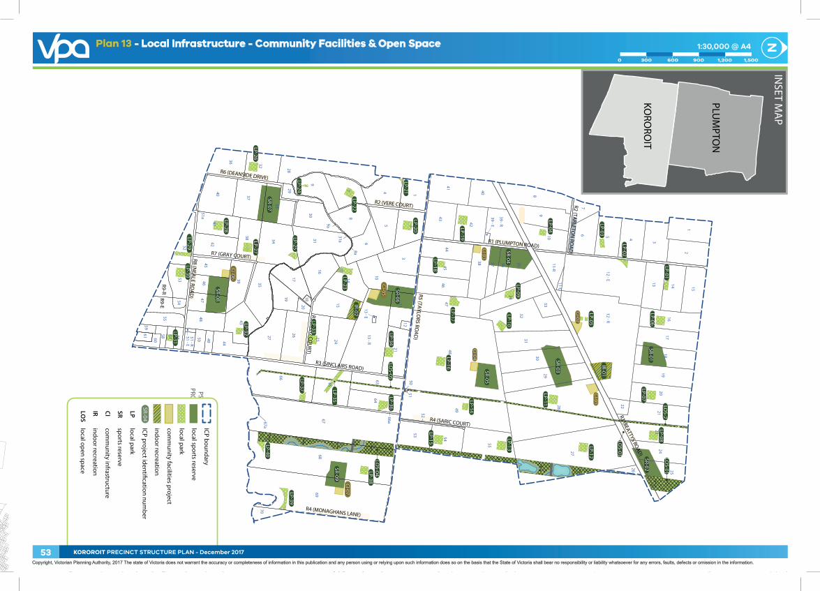
Plan 13 - Local Infrastructure - Community Facilities & Open Space
53 KOROROIT PRECINCT STRUCTURE PLAN - December 2017
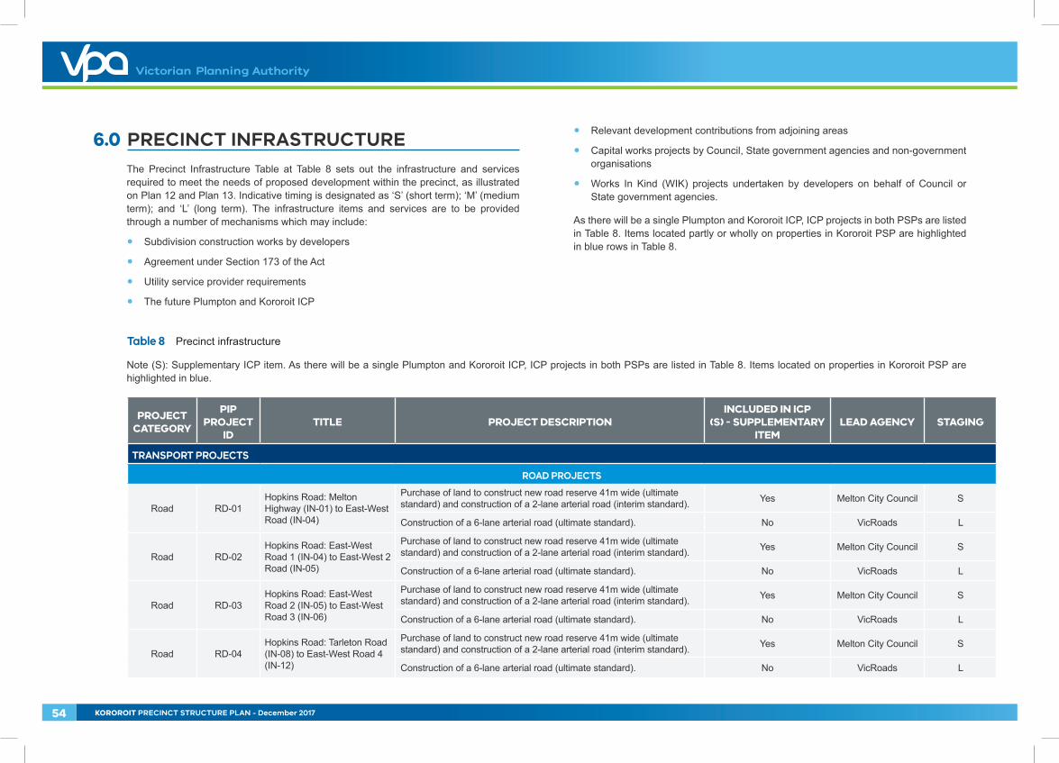
6.0 PRECINCT INFRASTRUCTURE The Precinct Infrastructure Table at Table 8 sets out the infrastructure and services required to meet the needs of proposed development within the precinct, as illustrated on Plan 12 and Plan 13. Indicative timing is designated as ‘S’ (short term); ‘M’ (medium term); and ‘L’ (long term). The infrastructure items and services are to be provided through a number of mechanisms which may include:
• Subdivision construction works by developers
• Agreement under Section 173 of the Act
• Utility service provider requirements
• The future Plumpton and Kororoit ICP
• Relevant development contributions from adjoining areas
• Capital works projects by Council, State government agencies and non-government organisations
• Works In Kind (WIK) projects undertaken by developers on behalf of Council or State government agencies.
As there will be a single Plumpton and Kororoit ICP, ICP projects in both PSPs are listed in Table 8. Items located partly or wholly on properties in Kororoit PSP are highlighted in blue rows in Table 8.
Table 8 Precinct infrastructure
Note (S): Supplementary ICP item. As there will be a single Plumpton and Kororoit ICP, ICP projects in both PSPs are listed in Table 8. Items located on properties in Kororoit PSP are highlighted in blue.
PROJECT CATEGORY
PIP PROJECT
IDTITLE PROJECT DESCRIPTION
INCLUDED IN ICP (S) - SUPPLEMENTARY
ITEMLEAD AGENCY STAGING
TRANSPORT PROJECTS
ROAD PROJECTS
Road RD-01Hopkins Road: Melton Highway (IN-01) to East-West Road (IN-04)
Purchase of land to construct new road reserve 41m wide (ultimate standard) and construction of a 2-lane arterial road (interim standard). Yes Melton City Council S
Construction of a 6-lane arterial road (ultimate standard). No VicRoads L
Road RD-02Hopkins Road: East-West Road 1 (IN-04) to East-West 2 Road (IN-05)
Purchase of land to construct new road reserve 41m wide (ultimate standard) and construction of a 2-lane arterial road (interim standard). Yes Melton City Council S
Construction of a 6-lane arterial road (ultimate standard). No VicRoads L
Road RD-03Hopkins Road: East-West Road 2 (IN-05) to East-West Road 3 (IN-06)
Purchase of land to construct new road reserve 41m wide (ultimate standard) and construction of a 2-lane arterial road (interim standard). Yes Melton City Council S
Construction of a 6-lane arterial road (ultimate standard). No VicRoads L
Road RD-04Hopkins Road: Tarleton Road (IN-08) to East-West Road 4 (IN-12)
Purchase of land to construct new road reserve 41m wide (ultimate standard) and construction of a 2-lane arterial road (interim standard). Yes Melton City Council S
Construction of a 6-lane arterial road (ultimate standard). No VicRoads L
54 KOROROIT PRECINCT STRUCTURE PLAN - December 2017
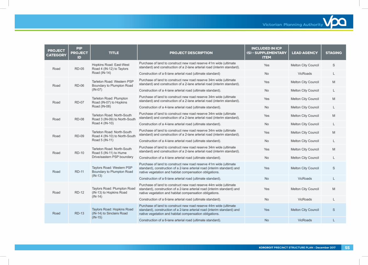
PROJECT CATEGORY
PIP PROJECT
IDTITLE PROJECT DESCRIPTION
INCLUDED IN ICP (S) - SUPPLEMENTARY
ITEMLEAD AGENCY STAGING
Road RD-05Hopkins Road: East-West Road 4 (IN-12) to Taylors Road (IN-14)
Purchase of land to construct new road reserve 41m wide (ultimate standard) and construction of a 2-lane arterial road (interim standard). Yes Melton City Council S
Construction of a 6-lane arterial road (ultimate standard) No VicRoads L
Road RD-06Tarleton Road: Western PSP Boundary to Plumpton Road (IN-07)
Purchase of land to construct new road reserve 34m wide (ultimate standard) and construction of a 2-lane arterial road (interim standard). Yes Melton City Council M
Construction of a 4-lane arterial road (ultimate standard). No Melton City Council L
Road RD-07Tarleton Road: Plumpton Road (IN-07) to Hopkins Road (IN-08)
Purchase of land to construct new road reserve 34m wide (ultimate standard) and construction of a 2-lane arterial road (interim standard). Yes Melton City Council M
Construction of a 4-lane arterial road (ultimate standard). No Melton City Council L
Road RD-08Tarleton Road: North-South Road 3 (IN-09) to North-South Road 4 (IN-10)
Purchase of land to construct new road reserve 34m wide (ultimate standard) and construction of a 2-lane arterial road (interim standard). Yes Melton City Council M
Construction of a 4-lane arterial road (ultimate standard). No Melton City Council L
Road RD-09Tarleton Road: North-South Road 4 (IN-10) to North-South Road 5 (IN-11)
Purchase of land to construct new road reserve 34m wide (ultimate standard) and construction of a 2-lane arterial road (interim standard). Yes Melton City Council M
Construction of a 4-lane arterial road (ultimate standard). No Melton City Council L
Road RD-10Tarleton Road: North-South Road 5 (IN-11) to Hume Drive/eastern PSP boundary
Purchase of land to construct new road reserve 34m wide (ultimate standard) and construction of a 2-lane arterial road (interim standard). Yes Melton City Council M
Construction of a 4-lane arterial road (ultimate standard). No Melton City Council L
Road RD-11Taylors Road: Western PSP Boundary to Plumpton Road (IN-13)
Purchase of land to construct new road reserve 41m wide (ultimate standard), construction of a 2-lane arterial road (interim standard) and native vegetation and habitat compensation obligations.
Yes Melton City Council S
Construction of a 6-lane arterial road (ultimate standard). No VicRoads L
Road RD-12Taylors Road: Plumpton Road (IN-13) to Hopkins Road (IN-14)
Purchase of land to construct new road reserve 44m wide (ultimate standard), construction of a 2-lane arterial road (interim standard) and native vegetation and habitat compensation obligations.
Yes Melton City Council M
Construction of a 6-lane arterial road (ultimate standard). No VicRoads L
Road RD-13Taylors Road: Hopkins Road (IN-14) to Sinclairs Road (IN-15)
Purchase of land to construct new road reserve 44m wide (ultimate standard), construction of a 2-lane arterial road (interim standard) and native vegetation and habitat compensation obligations.
Yes Melton City Council S
Construction of a 6-lane arterial road (ultimate standard). No VicRoads L
KOROROIT PRECINCT STRUCTURE PLAN - December 2017 55
PROJECT CATEGORY
PIP PROJECT
IDTITLE PROJECT DESCRIPTION
INCLUDED IN ICP (S) - SUPPLEMENTARY
ITEMLEAD AGENCY STAGING
Road RD-14 Taylors Road: Sinclairs Road (IN-15) to Saric Court (IN-16)
Purchase of land to construct new road reserve 44m wide (ultimate standard), construction of a 2-lane arterial road (interim standard) and native vegetation and habitat compensation obligations.
Yes Melton City Council S
Construction of a 6-lane arterial road (ultimate standard). No VicRoads L
Road RD-15 Taylors Road: Saric Court (IN-16) to City Vista Court (IN-17)
Purchase of land to construct new road reserve 44m wide (ultimate standard), construction of a 2-lane arterial road (interim standard) and native vegetation and habitat compensation obligations.
Yes Melton City Council S
Construction of a 6-lane arterial road (ultimate standard). No VicRoads L
Road RD-16Taylors Road: City Vista Court (IN-17) to Eastern PSP Boundary
Purchase of land to construct new road reserve 44m wide (ultimate standard), construction of a 2-lane arterial road (interim standard) and native vegetation and habitat compensation obligations.
Yes Melton City Council S
Construction of a 6-lane arterial road (ultimate standard). No VicRoads L
Road RD-17Hopkins Road: Taylors Road (IN-14) to East-West Road 5 (IN-18)
Purchase of land to construct new road reserve 41m wide (ultimate standard) and construction of a 2-lane arterial road (interim standard). Yes Melton City Council S
Construction of a 6-lane arterial road (ultimate standard). No VicRoads L
Road RD-18Hopkins Road: East-West Road 5 (IN-18) to Reed Court (IN-19)
Purchase of land to construct new road reserve 41m wide (ultimate standard) and construction of a 2-lane arterial road (interim standard). Yes Melton City Council S
Construction of a 6-lane arterial road (ultimate standard). No VicRoads L
Road RD-19Hopkins Road: Reed Court (IN-19) to Hopkins Road Bridge (BR-02)
Purchase of land to construct new road reserve 41m wide (ultimate standard) and construction of a 2-lane arterial road (interim standard). Yes Melton City Council S
Construction of a 6-lane arterial road (ultimate standard). No VicRoads L
Road RD-20Hopkins Road: Hopkins Road Bridge (BR-02) to East-West Road 6 (IN-20)
Purchase of land to construct new road reserve 41m wide (ultimate standard) and construction of a 2-lane arterial road (interim standard). Yes Melton City Council S
Construction of a 6-lane arterial road (ultimate standard). No VicRoads L
INTERSECTION PROJECTS
Intersection IN-01 Intersection: Hopkins Road and Melton Highway
Purchase of land (ultimate standard - Hopkins Road only) and construction of primary arterial to primary arterial signalised T intersection (interim standard).
Yes Melton City Council S
Construction of 4-way signalised intersection (ultimate standard). No VicRoads L
Intersection IN-02 Intersection: North-South Road 1 and Melton Highway
Purchase of land (ultimate standard - connector leg only) and construction of connector road to primary arterial signalised T intersection (interim standard).
Yes Melton City Council S
Construction of signalised T intersection (ultimate standard). No VicRoads L
56 KOROROIT PRECINCT STRUCTURE PLAN - December 2017
PROJECT CATEGORY
PIP PROJECT
IDTITLE PROJECT DESCRIPTION
INCLUDED IN ICP (S) - SUPPLEMENTARY
ITEMLEAD AGENCY STAGING
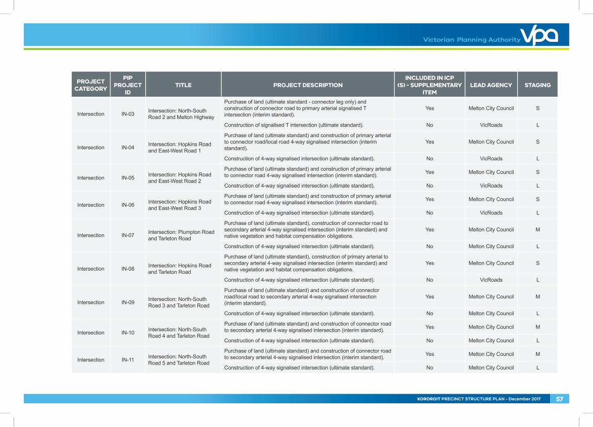
Intersection IN-03 Intersection: North-South Road 2 and Melton Highway
Purchase of land (ultimate standard - connector leg only) and construction of connector road to primary arterial signalised T intersection (interim standard).
Yes Melton City Council S
Construction of signalised T intersection (ultimate standard). No VicRoads L
Intersection IN-04 Intersection: Hopkins Road and East-West Road 1
Purchase of land (ultimate standard) and construction of primary arterial to connector road/local road 4-way signalised intersection (interim standard).
Yes Melton City Council S
Construction of 4-way signalised intersection (ultimate standard). No VicRoads L
Intersection IN-05 Intersection: Hopkins Road and East-West Road 2
Purchase of land (ultimate standard) and construction of primary arterial to connector road 4-way signalised intersection (interim standard). Yes Melton City Council S
Construction of 4-way signalised intersection (ultimate standard). No VicRoads L
Intersection IN-06 Intersection: Hopkins Road and East-West Road 3
Purchase of land (ultimate standard) and construction of primary arterial to connector road 4-way signalised intersection (interim standard). Yes Melton City Council S
Construction of 4-way signalised intersection (ultimate standard). No VicRoads L
Intersection IN-07 Intersection: Plumpton Road and Tarleton Road
Purchase of land (ultimate standard), construction of connector road to secondary arterial 4-way signalised intersection (interim standard) and native vegetation and habitat compensation obligations.
Yes Melton City Council M
Construction of 4-way signalised intersection (ultimate standard). No Melton City Council L
Intersection IN-08 Intersection: Hopkins Road and Tarleton Road
Purchase of land (ultimate standard), construction of primary arterial to secondary arterial 4-way signalised intersection (interim standard) and native vegetation and habitat compensation obligations.
Yes Melton City Council S
Construction of 4-way signalised intersection (ultimate standard). No VicRoads L
Intersection IN-09 Intersection: North-South Road 3 and Tarleton Road
Purchase of land (ultimate standard) and construction of connector road/local road to secondary arterial 4-way signalised intersection (interim standard).
Yes Melton City Council M
Construction of 4-way signalised intersection (ultimate standard). No Melton City Council L
Intersection IN-10 Intersection: North-South Road 4 and Tarleton Road
Purchase of land (ultimate standard) and construction of connector road to secondary arterial 4-way signalised intersection (interim standard). Yes Melton City Council M
Construction of 4-way signalised intersection (ultimate standard). No Melton City Council L
Intersection IN-11 Intersection: North-South Road 5 and Tarleton Road
Purchase of land (ultimate standard) and construction of connector road to secondary arterial 4-way signalised intersection (interim standard). Yes Melton City Council M
Construction of 4-way signalised intersection (ultimate standard). No Melton City Council L
KOROROIT PRECINCT STRUCTURE PLAN - December 2017 57
PROJECT CATEGORY
PIP PROJECT
IDTITLE PROJECT DESCRIPTION
INCLUDED IN ICP (S) - SUPPLEMENTARY
ITEMLEAD AGENCY STAGING
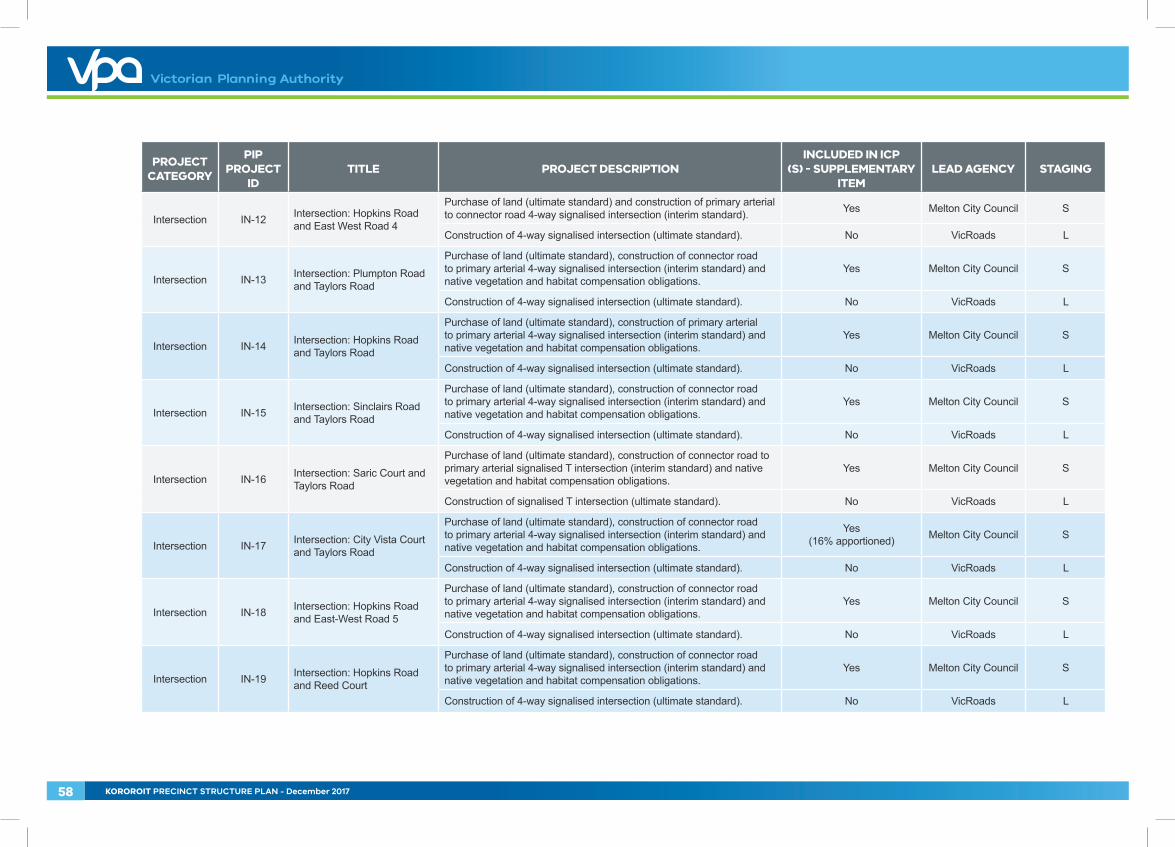
Intersection IN-12 Intersection: Hopkins Road and East West Road 4
Purchase of land (ultimate standard) and construction of primary arterial to connector road 4-way signalised intersection (interim standard). Yes Melton City Council S
Construction of 4-way signalised intersection (ultimate standard). No VicRoads L
Intersection IN-13 Intersection: Plumpton Road and Taylors Road
Purchase of land (ultimate standard), construction of connector road to primary arterial 4-way signalised intersection (interim standard) and native vegetation and habitat compensation obligations.
Yes Melton City Council S
Construction of 4-way signalised intersection (ultimate standard). No VicRoads L
Intersection IN-14 Intersection: Hopkins Road and Taylors Road
Purchase of land (ultimate standard), construction of primary arterial to primary arterial 4-way signalised intersection (interim standard) and native vegetation and habitat compensation obligations.
Yes Melton City Council S
Construction of 4-way signalised intersection (ultimate standard). No VicRoads L
Intersection IN-15 Intersection: Sinclairs Road and Taylors Road
Purchase of land (ultimate standard), construction of connector road to primary arterial 4-way signalised intersection (interim standard) and native vegetation and habitat compensation obligations.
Yes Melton City Council S
Construction of 4-way signalised intersection (ultimate standard). No VicRoads L
Intersection IN-16 Intersection: Saric Court and Taylors Road
Purchase of land (ultimate standard), construction of connector road to primary arterial signalised T intersection (interim standard) and native vegetation and habitat compensation obligations.
Yes Melton City Council S
Construction of signalised T intersection (ultimate standard). No VicRoads L
Intersection IN-17 Intersection: City Vista Court and Taylors Road
Purchase of land (ultimate standard), construction of connector road to primary arterial 4-way signalised intersection (interim standard) and native vegetation and habitat compensation obligations.
Yes (16% apportioned) Melton City Council S
Construction of 4-way signalised intersection (ultimate standard). No VicRoads L
Intersection IN-18 Intersection: Hopkins Road and East-West Road 5
Purchase of land (ultimate standard), construction of connector road to primary arterial 4-way signalised intersection (interim standard) and native vegetation and habitat compensation obligations.
Yes Melton City Council S
Construction of 4-way signalised intersection (ultimate standard). No VicRoads L
Intersection IN-19 Intersection: Hopkins Road and Reed Court
Purchase of land (ultimate standard), construction of connector road to primary arterial 4-way signalised intersection (interim standard) and native vegetation and habitat compensation obligations.
Yes Melton City Council S
Construction of 4-way signalised intersection (ultimate standard). No VicRoads L
58 KOROROIT PRECINCT STRUCTURE PLAN - December 2017
PROJECT CATEGORY
PIP PROJECT
IDTITLE PROJECT DESCRIPTION
INCLUDED IN ICP (S) - SUPPLEMENTARY
ITEMLEAD AGENCY STAGING
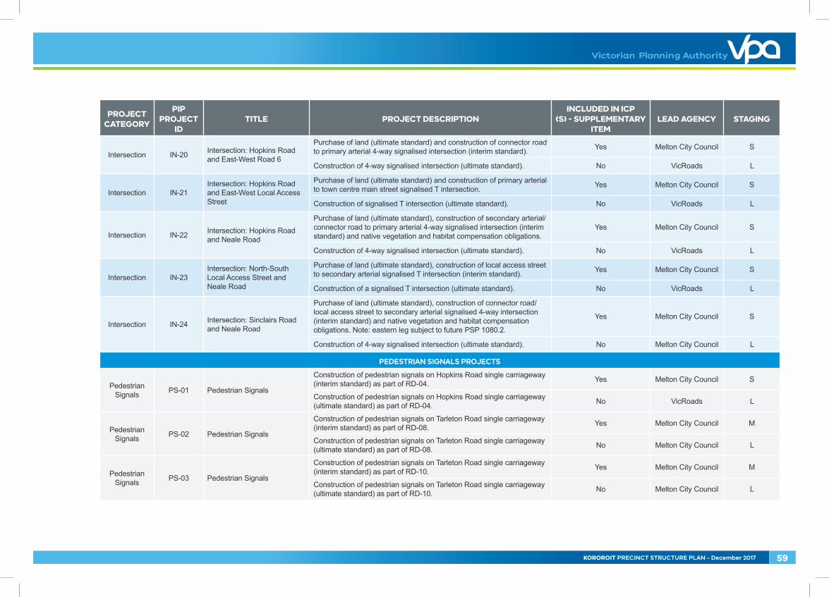
Intersection IN-20 Intersection: Hopkins Road and East-West Road 6
Purchase of land (ultimate standard) and construction of connector road to primary arterial 4-way signalised intersection (interim standard). Yes Melton City Council S
Construction of 4-way signalised intersection (ultimate standard). No VicRoads L
Intersection IN-21Intersection: Hopkins Road and East-West Local Access Street
Purchase of land (ultimate standard) and construction of primary arterial to town centre main street signalised T intersection. Yes Melton City Council S
Construction of signalised T intersection (ultimate standard). No VicRoads L
Intersection IN-22 Intersection: Hopkins Road and Neale Road
Purchase of land (ultimate standard), construction of secondary arterial/connector road to primary arterial 4-way signalised intersection (interim standard) and native vegetation and habitat compensation obligations.
Yes Melton City Council S
Construction of 4-way signalised intersection (ultimate standard). No VicRoads L
Intersection IN-23Intersection: North-South Local Access Street and Neale Road
Purchase of land (ultimate standard), construction of local access street to secondary arterial signalised T intersection (interim standard). Yes Melton City Council S
Construction of a signalised T intersection (ultimate standard). No VicRoads L
Intersection IN-24 Intersection: Sinclairs Road and Neale Road
Purchase of land (ultimate standard), construction of connector road/local access street to secondary arterial signalised 4-way intersection (interim standard) and native vegetation and habitat compensation obligations. Note: eastern leg subject to future PSP 1080.2.
Yes Melton City Council S
Construction of 4-way signalised intersection (ultimate standard). No Melton City Council L
PEDESTRIAN SIGNALS PROJECTS
Pedestrian Signals PS-01 Pedestrian Signals
Construction of pedestrian signals on Hopkins Road single carriageway (interim standard) as part of RD-04. Yes Melton City Council S
Construction of pedestrian signals on Hopkins Road single carriageway (ultimate standard) as part of RD-04. No VicRoads L
Pedestrian Signals PS-02 Pedestrian Signals
Construction of pedestrian signals on Tarleton Road single carriageway (interim standard) as part of RD-08. Yes Melton City Council M
Construction of pedestrian signals on Tarleton Road single carriageway (ultimate standard) as part of RD-08. No Melton City Council L
Pedestrian Signals PS-03 Pedestrian Signals
Construction of pedestrian signals on Tarleton Road single carriageway (interim standard) as part of RD-10. Yes Melton City Council M
Construction of pedestrian signals on Tarleton Road single carriageway (ultimate standard) as part of RD-10. No Melton City Council L
KOROROIT PRECINCT STRUCTURE PLAN - December 2017 59
PROJECT CATEGORY
PIP PROJECT
IDTITLE PROJECT DESCRIPTION
INCLUDED IN ICP (S) - SUPPLEMENTARY
ITEMLEAD AGENCY STAGING
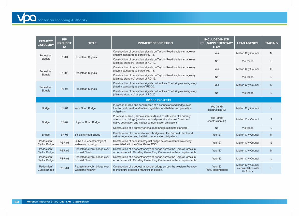
Pedestrian Signals PS-04 Pedestrian Signals
Construction of pedestrian signals on Taylors Road single carriageway (interim standard) as part of RD-12. Yes Melton City Council M
Construction of pedestrian signals on Taylors Road single carriageway (ultimate standard) as part of RD-12. No VicRoads L
Pedestrian Signals PS-05 Pedestrian Signals
Construction of pedestrian signals on Taylors Road single carriageway (interim standard) as part of RD-15. Yes Melton City Council S
Construction of pedestrian signals on Taylors Road single carriageway (ultimate standard) as part of RD-15. No VicRoads L
Pedestrian Signals PS-06 Pedestrian Signals
Construction of pedestrian signals on Hopkins Road single carriageway (interim standard) as part of RD-20. Yes Melton City Council S
Construction of pedestrian signals on Hopkins Road single carriageway (ultimate standard) as part of RD-20. No VicRoads L
BRIDGE PROJECTS
Bridge BR-01 Vere Court BridgePurchase of land and construction of a connector road bridge over the Kororoit Creek and native vegetation and habitat compensation obligations.
Yes (land) construction (S) Melton City Council L
Bridge BR-02 Hopkins Road Bridge
Purchase of land (ultimate standard) and construction of a primary arterial road bridge (interim standard) over the Kororoit Creek and native vegetation and habitat compensation obligations.
Yes (land) construction (S) Melton City Council S
Construction of a primary arterial road bridge (ultimate standard). No VicRoads L
Bridge BR-03 Sinclairs Road Bridge Construction of a connector road bridge over the Kororoit Creek and native vegetation and habitat compensation obligations. Yes (S) Melton City Council M
Pedestrian/Cyclist Bridge PBR-01 Culvert - Pedestrian/cyclist
waterway crossingConstruction of pedestrian/cyclist bridge across a natural waterway associated with the Olive Grove DSS. Yes (S) Melton City Council S
Pedestrian/Cyclist Bridge PBR-02 Pedestrian/cyclist bridge over
Kororoit CreekConstruction of a pedestrian/cyclist bridge across the Kororoit Creek in accordance with Growling Grass Frog Conservation Area requirements. Yes (S) Melton City Council M
Pedestrian/Cyclist Bridge PBR-03 Pedestrian/cyclist bridge over
Kororoit CreekConstruction of a pedestrian/cyclist bridge across the Kororoit Creek in accordance with Growling Grass Frog Conservation Area requirements. Yes (S) Melton City Council L
Pedestrian/Cyclist Bridge PBR-04 Pedestrian/cyclist bridge over
Western FreewayConstruction of a pedestrian/cyclist bridge across the Western Freeway to the future proposed Mt Atkinson station.
Yes (S) (50% apportioned)
Melton City Council in consultation with
VicRoadsL
60 KOROROIT PRECINCT STRUCTURE PLAN - December 2017
PROJECT CATEGORY
PIP PROJECT
IDTITLE PROJECT DESCRIPTION
INCLUDED IN ICP (S) - SUPPLEMENTARY
ITEMLEAD AGENCY STAGING
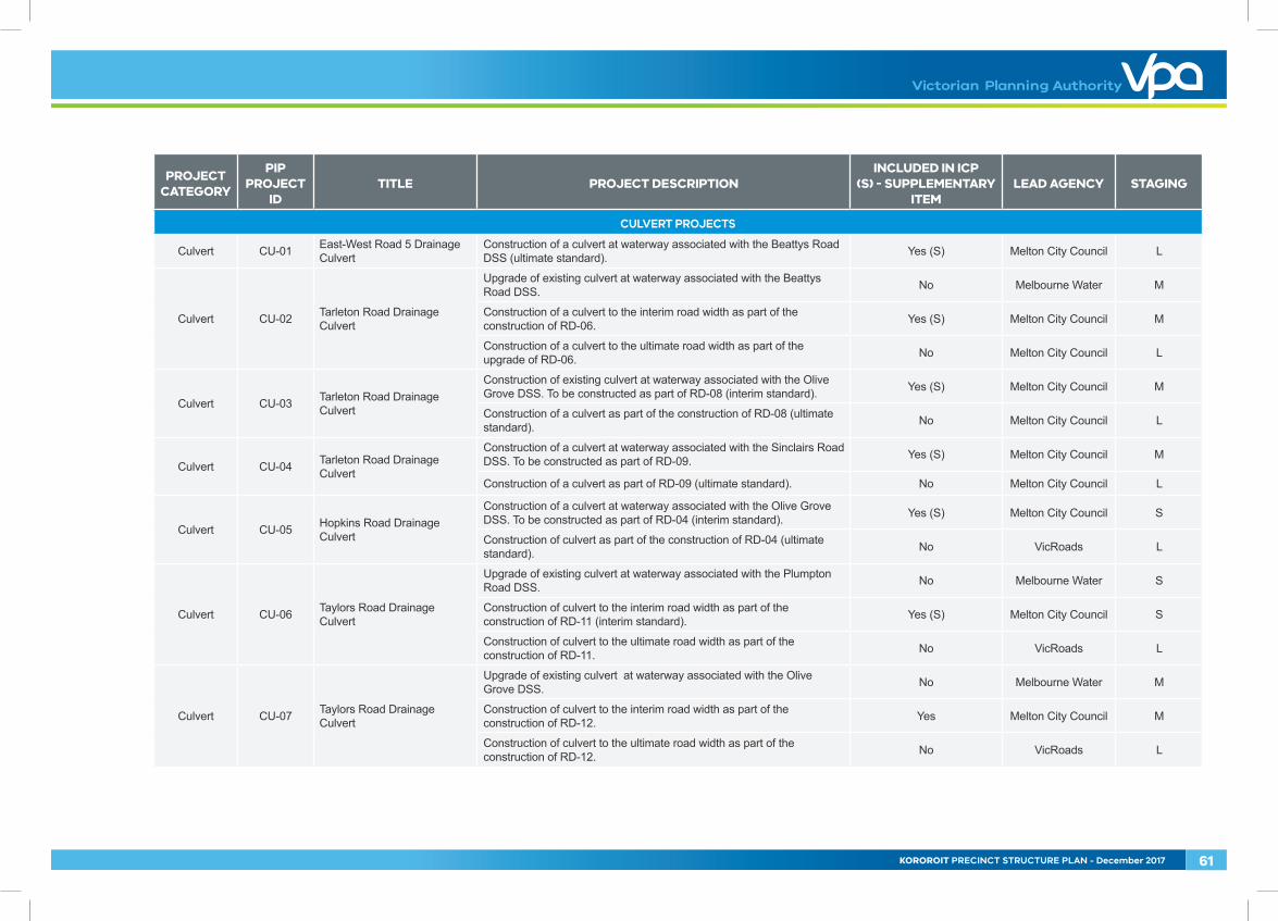
CULVERT PROJECTS
Culvert CU-01 East-West Road 5 Drainage Culvert
Construction of a culvert at waterway associated with the Beattys Road DSS (ultimate standard). Yes (S) Melton City Council L
Culvert CU-02 Tarleton Road Drainage Culvert
Upgrade of existing culvert at waterway associated with the Beattys Road DSS. No Melbourne Water M
Construction of a culvert to the interim road width as part of the construction of RD-06. Yes (S) Melton City Council M
Construction of a culvert to the ultimate road width as part of the upgrade of RD-06. No Melton City Council L
Culvert CU-03 Tarleton Road Drainage Culvert
Construction of existing culvert at waterway associated with the Olive Grove DSS. To be constructed as part of RD-08 (interim standard). Yes (S) Melton City Council M
Construction of a culvert as part of the construction of RD-08 (ultimate standard). No Melton City Council L
Culvert CU-04 Tarleton Road Drainage Culvert
Construction of a culvert at waterway associated with the Sinclairs Road DSS. To be constructed as part of RD-09. Yes (S) Melton City Council M
Construction of a culvert as part of RD-09 (ultimate standard). No Melton City Council L
Culvert CU-05 Hopkins Road Drainage Culvert
Construction of a culvert at waterway associated with the Olive Grove DSS. To be constructed as part of RD-04 (interim standard). Yes (S) Melton City Council S
Construction of culvert as part of the construction of RD-04 (ultimate standard). No VicRoads L
Culvert CU-06 Taylors Road Drainage Culvert
Upgrade of existing culvert at waterway associated with the Plumpton Road DSS. No Melbourne Water S
Construction of culvert to the interim road width as part of the construction of RD-11 (interim standard). Yes (S) Melton City Council S
Construction of culvert to the ultimate road width as part of the construction of RD-11. No VicRoads L
Culvert CU-07 Taylors Road Drainage Culvert
Upgrade of existing culvert at waterway associated with the Olive Grove DSS. No Melbourne Water M
Construction of culvert to the interim road width as part of the construction of RD-12. Yes Melton City Council M
Construction of culvert to the ultimate road width as part of the construction of RD-12. No VicRoads L
KOROROIT PRECINCT STRUCTURE PLAN - December 2017 61
PROJECT CATEGORY
PIP PROJECT
IDTITLE PROJECT DESCRIPTION
INCLUDED IN ICP (S) - SUPPLEMENTARY
ITEMLEAD AGENCY STAGING
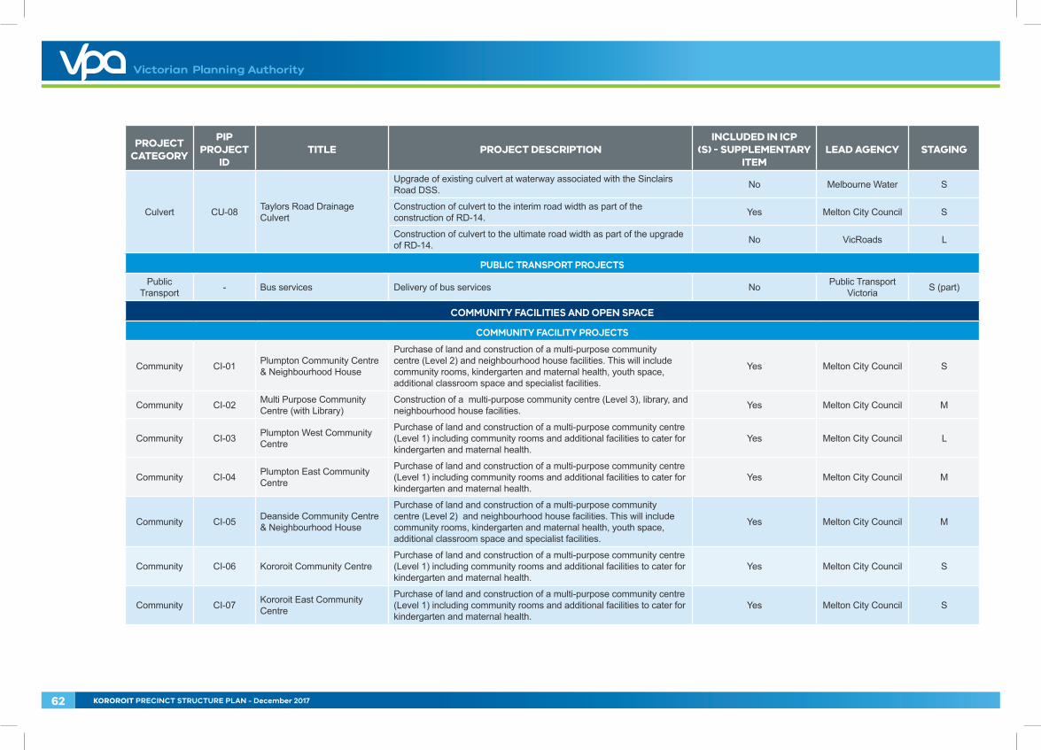
Culvert CU-08 Taylors Road Drainage Culvert
Upgrade of existing culvert at waterway associated with the Sinclairs Road DSS. No Melbourne Water S
Construction of culvert to the interim road width as part of the construction of RD-14. Yes Melton City Council S
Construction of culvert to the ultimate road width as part of the upgrade of RD-14. No VicRoads L
PUBLIC TRANSPORT PROJECTS
Public Transport - Bus services Delivery of bus services No Public Transport
Victoria S (part)
COMMUNITY FACILITIES AND OPEN SPACE
COMMUNITY FACILITY PROJECTS
Community CI-01 Plumpton Community Centre & Neighbourhood House
Purchase of land and construction of a multi-purpose community centre (Level 2) and neighbourhood house facilities. This will include community rooms, kindergarten and maternal health, youth space, additional classroom space and specialist facilities.
Yes Melton City Council S
Community CI-02 Multi Purpose Community Centre (with Library)
Construction of a multi-purpose community centre (Level 3), library, and neighbourhood house facilities. Yes Melton City Council M
Community CI-03 Plumpton West Community Centre
Purchase of land and construction of a multi-purpose community centre (Level 1) including community rooms and additional facilities to cater for kindergarten and maternal health.
Yes Melton City Council L
Community CI-04 Plumpton East Community Centre
Purchase of land and construction of a multi-purpose community centre (Level 1) including community rooms and additional facilities to cater for kindergarten and maternal health.
Yes Melton City Council M
Community CI-05 Deanside Community Centre & Neighbourhood House
Purchase of land and construction of a multi-purpose community centre (Level 2) and neighbourhood house facilities. This will include community rooms, kindergarten and maternal health, youth space, additional classroom space and specialist facilities.
Yes Melton City Council M
Community CI-06 Kororoit Community Centre Purchase of land and construction of a multi-purpose community centre (Level 1) including community rooms and additional facilities to cater for kindergarten and maternal health.
Yes Melton City Council S
Community CI-07 Kororoit East Community Centre
Purchase of land and construction of a multi-purpose community centre (Level 1) including community rooms and additional facilities to cater for kindergarten and maternal health.
Yes Melton City Council S
62 KOROROIT PRECINCT STRUCTURE PLAN - December 2017
PROJECT CATEGORY
PIP PROJECT
IDTITLE PROJECT DESCRIPTION
INCLUDED IN ICP (S) - SUPPLEMENTARY
ITEMLEAD AGENCY STAGING
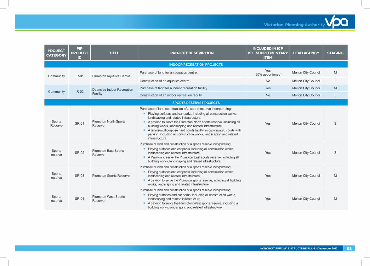
INDOOR RECREATION PROJECTS
Community IR-01 Plumpton Aquatics CentrePurchase of land for an aquatics centre. Yes
(50% apportioned) Melton City Council M
Construction of an aquatics centre. No Melton City Council L
Community IR-02 Deanside Indoor Recreation Facility
Purchase of land for a indoor recreation facility. Yes Melton City Council M
Construction of an indoor recreation facility. No Melton City Council L
SPORTS RESERVE PROJECTS
Sports Reserve SR-01 Plumpton North Sports
Reserve
Purchase of land construction of a sports reserve incorporating: • Playing surfaces and car parks, including all construction works,
landscaping and related infrastructure.• A pavilion to serve the Plumpton North sports reserve, including all
building works, landscaping and related infrastructure.• A tennis/multipurpose hard courts facility incorporating 6 courts with
parking, including all construction works, landscaping and related infrastructure.
Yes Melton City Council S
Sports reserve SR-02 Plumpton East Sports
Reserve
Purchase of land and construction of a sports reserve incorporating: • Playing surfaces and car parks, including all construction works,
landscaping and related infrastructure. • A Pavilion to serve the Plumpton East sports reserve, including all
building works, landscaping and related infrastructure.
Yes Melton City Council S
Sports reserve SR-03 Plumpton Sports Reserve
Purchase of land and construction of a sports reserve incorporating: • Playing surfaces and car parks, including all construction works,
landscaping and related infrastructure.• A pavilion to serve the Plumpton sports reserve, including all building
works, landscaping and related infrastructure.
Yes Melton City Council M
Sports reserve SR-04 Plumpton West Sports
Reserve
Purchase of land and construction of a sports reserve incorporating: • Playing surfaces and car parks, including all construction works,
landscaping and related infrastructure. • A pavilion to serve the Plumpton West sports reserve, including all
building works, landscaping and related infrastructure.
Yes Melton City Council M
KOROROIT PRECINCT STRUCTURE PLAN - December 2017 63
PROJECT CATEGORY
PIP PROJECT
IDTITLE PROJECT DESCRIPTION
INCLUDED IN ICP (S) - SUPPLEMENTARY
ITEMLEAD AGENCY STAGING
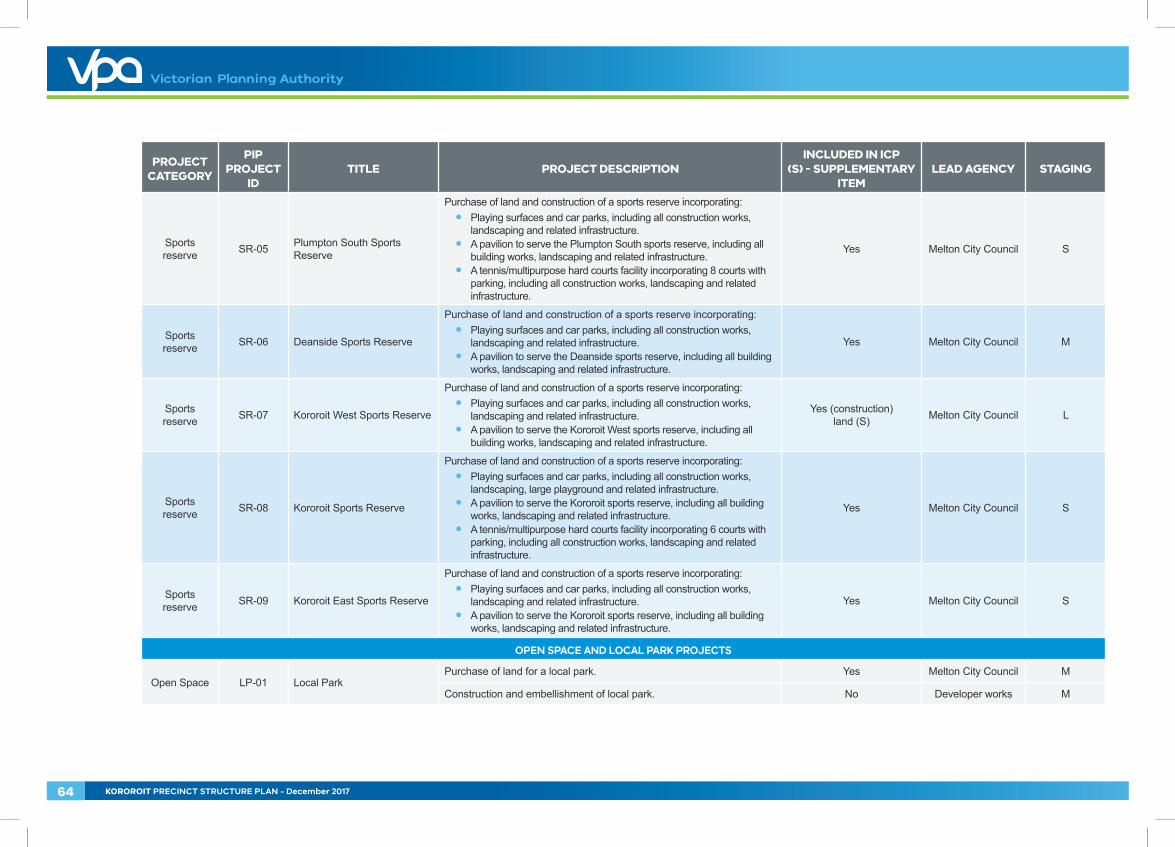
Sports reserve SR-05 Plumpton South Sports
Reserve
Purchase of land and construction of a sports reserve incorporating:• Playing surfaces and car parks, including all construction works,
landscaping and related infrastructure. • A pavilion to serve the Plumpton South sports reserve, including all
building works, landscaping and related infrastructure.• A tennis/multipurpose hard courts facility incorporating 8 courts with
parking, including all construction works, landscaping and related infrastructure.
Yes Melton City Council S
Sports reserve SR-06 Deanside Sports Reserve
Purchase of land and construction of a sports reserve incorporating:• Playing surfaces and car parks, including all construction works,
landscaping and related infrastructure.• A pavilion to serve the Deanside sports reserve, including all building
works, landscaping and related infrastructure.
Yes Melton City Council M
Sports reserve SR-07 Kororoit West Sports Reserve
Purchase of land and construction of a sports reserve incorporating:• Playing surfaces and car parks, including all construction works,
landscaping and related infrastructure.• A pavilion to serve the Kororoit West sports reserve, including all
building works, landscaping and related infrastructure.
Yes (construction) land (S) Melton City Council L
Sports reserve SR-08 Kororoit Sports Reserve
Purchase of land and construction of a sports reserve incorporating:• Playing surfaces and car parks, including all construction works,
landscaping, large playground and related infrastructure.• A pavilion to serve the Kororoit sports reserve, including all building
works, landscaping and related infrastructure.• A tennis/multipurpose hard courts facility incorporating 6 courts with
parking, including all construction works, landscaping and related infrastructure.
Yes Melton City Council S
Sports reserve SR-09 Kororoit East Sports Reserve
Purchase of land and construction of a sports reserve incorporating:• Playing surfaces and car parks, including all construction works,
landscaping and related infrastructure.• A pavilion to serve the Kororoit sports reserve, including all building
works, landscaping and related infrastructure.
Yes Melton City Council S
OPEN SPACE AND LOCAL PARK PROJECTS
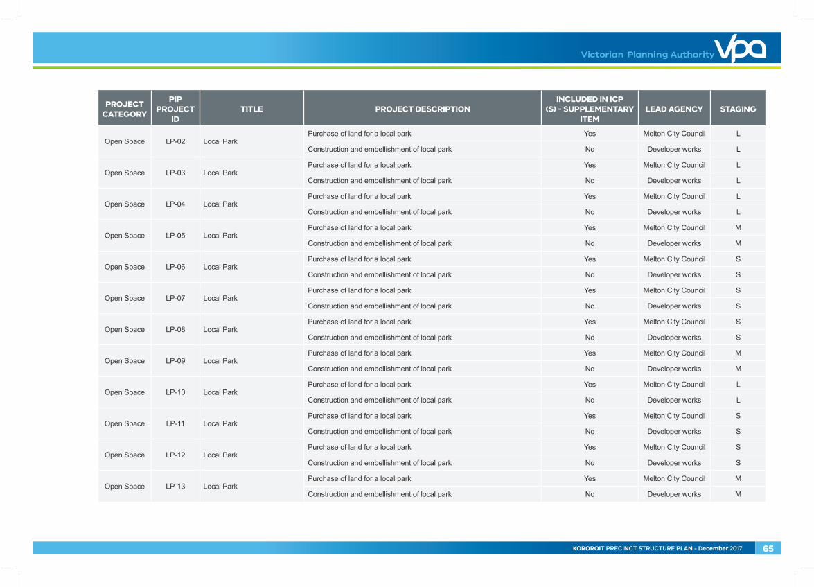
Open Space LP-01 Local ParkPurchase of land for a local park. Yes Melton City Council M
Construction and embellishment of local park. No Developer works M
64 KOROROIT PRECINCT STRUCTURE PLAN - December 2017
PROJECT CATEGORY
PIP PROJECT
IDTITLE PROJECT DESCRIPTION
INCLUDED IN ICP (S) - SUPPLEMENTARY
ITEMLEAD AGENCY STAGING
Open Space LP-02 Local ParkPurchase of land for a local park Yes Melton City Council L
Construction and embellishment of local park No Developer works L
Open Space LP-03 Local ParkPurchase of land for a local park Yes Melton City Council L
Construction and embellishment of local park No Developer works L
Open Space LP-04 Local ParkPurchase of land for a local park Yes Melton City Council L
Construction and embellishment of local park No Developer works L
Open Space LP-05 Local ParkPurchase of land for a local park Yes Melton City Council M
Construction and embellishment of local park No Developer works M
Open Space LP-06 Local ParkPurchase of land for a local park Yes Melton City Council S
Construction and embellishment of local park No Developer works S
Open Space LP-07 Local ParkPurchase of land for a local park Yes Melton City Council S
Construction and embellishment of local park No Developer works S
Open Space LP-08 Local ParkPurchase of land for a local park Yes Melton City Council S
Construction and embellishment of local park No Developer works S
Open Space LP-09 Local ParkPurchase of land for a local park Yes Melton City Council M
Construction and embellishment of local park No Developer works M
Open Space LP-10 Local ParkPurchase of land for a local park Yes Melton City Council L
Construction and embellishment of local park No Developer works L
Open Space LP-11 Local ParkPurchase of land for a local park Yes Melton City Council S
Construction and embellishment of local park No Developer works S
Open Space LP-12 Local ParkPurchase of land for a local park Yes Melton City Council S
Construction and embellishment of local park No Developer works S
Open Space LP-13 Local ParkPurchase of land for a local park Yes Melton City Council M
Construction and embellishment of local park No Developer works M
KOROROIT PRECINCT STRUCTURE PLAN - December 2017 65
PROJECT CATEGORY
PIP PROJECT
IDTITLE PROJECT DESCRIPTION
INCLUDED IN ICP (S) - SUPPLEMENTARY
ITEMLEAD AGENCY STAGING
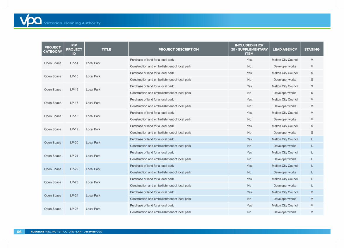
Open Space LP-14 Local ParkPurchase of land for a local park Yes Melton City Council M
Construction and embellishment of local park No Developer works M
Open Space LP-15 Local ParkPurchase of land for a local park Yes Melton City Council S
Construction and embellishment of local park No Developer works S
Open Space LP-16 Local ParkPurchase of land for a local park Yes Melton City Council S
Construction and embellishment of local park No Developer works S
Open Space LP-17 Local ParkPurchase of land for a local park Yes Melton City Council M
Construction and embellishment of local park No Developer works M
Open Space LP-18 Local ParkPurchase of land for a local park Yes Melton City Council M
Construction and embellishment of local park No Developer works M
Open Space LP-19 Local ParkPurchase of land for a local park Yes Melton City Council S
Construction and embellishment of local park No Developer works S
Open Space LP-20 Local ParkPurchase of land for a local park Yes Melton City Council L
Construction and embellishment of local park No Developer works L
Open Space LP-21 Local ParkPurchase of land for a local park Yes Melton City Council L
Construction and embellishment of local park No Developer works L
Open Space LP-22 Local ParkPurchase of land for a local park Yes Melton City Council L
Construction and embellishment of local park No Developer works L
Open Space LP-23 Local ParkPurchase of land for a local park Yes Melton City Council L
Construction and embellishment of local park No Developer works L
Open Space LP-24 Local ParkPurchase of land for a local park Yes Melton City Council M
Construction and embellishment of local park No Developer works M
Open Space LP-25 Local ParkPurchase of land for a local park Yes Melton City Council M
Construction and embellishment of local park No Developer works M
66 KOROROIT PRECINCT STRUCTURE PLAN - December 2017
PROJECT CATEGORY
PIP PROJECT
IDTITLE PROJECT DESCRIPTION
INCLUDED IN ICP (S) - SUPPLEMENTARY
ITEMLEAD AGENCY STAGING
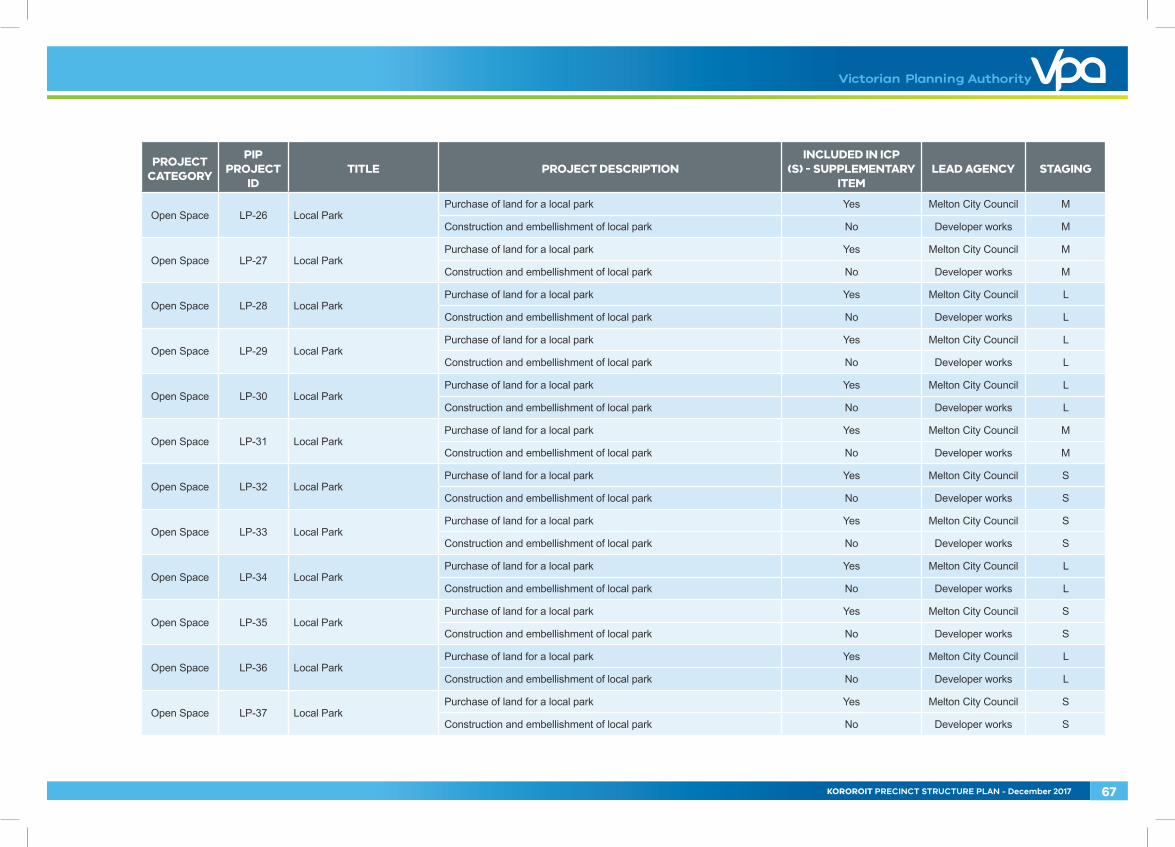
Open Space LP-26 Local ParkPurchase of land for a local park Yes Melton City Council M
Construction and embellishment of local park No Developer works M
Open Space LP-27 Local ParkPurchase of land for a local park Yes Melton City Council M
Construction and embellishment of local park No Developer works M
Open Space LP-28 Local ParkPurchase of land for a local park Yes Melton City Council L
Construction and embellishment of local park No Developer works L
Open Space LP-29 Local ParkPurchase of land for a local park Yes Melton City Council L
Construction and embellishment of local park No Developer works L
Open Space LP-30 Local ParkPurchase of land for a local park Yes Melton City Council L
Construction and embellishment of local park No Developer works L
Open Space LP-31 Local ParkPurchase of land for a local park Yes Melton City Council M
Construction and embellishment of local park No Developer works M
Open Space LP-32 Local ParkPurchase of land for a local park Yes Melton City Council S
Construction and embellishment of local park No Developer works S
Open Space LP-33 Local ParkPurchase of land for a local park Yes Melton City Council S
Construction and embellishment of local park No Developer works S
Open Space LP-34 Local ParkPurchase of land for a local park Yes Melton City Council L
Construction and embellishment of local park No Developer works L
Open Space LP-35 Local ParkPurchase of land for a local park Yes Melton City Council S
Construction and embellishment of local park No Developer works S
Open Space LP-36 Local ParkPurchase of land for a local park Yes Melton City Council L
Construction and embellishment of local park No Developer works L
Open Space LP-37 Local ParkPurchase of land for a local park Yes Melton City Council S
Construction and embellishment of local park No Developer works S
KOROROIT PRECINCT STRUCTURE PLAN - December 2017 67
PROJECT CATEGORY
PIP PROJECT
IDTITLE PROJECT DESCRIPTION
INCLUDED IN ICP (S) - SUPPLEMENTARY
ITEMLEAD AGENCY STAGING
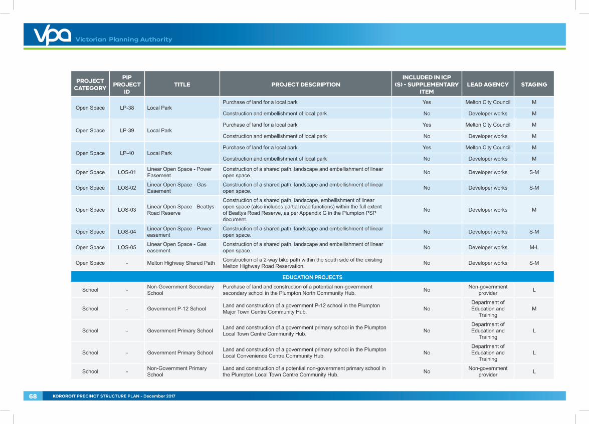
Open Space LP-38 Local ParkPurchase of land for a local park Yes Melton City Council M
Construction and embellishment of local park No Developer works M
Open Space LP-39 Local ParkPurchase of land for a local park Yes Melton City Council M
Construction and embellishment of local park No Developer works M
Open Space LP-40 Local ParkPurchase of land for a local park Yes Melton City Council M
Construction and embellishment of local park No Developer works M
Open Space LOS-01 Linear Open Space - Power Easement
Construction of a shared path, landscape and embellishment of linear open space. No Developer works S-M
Open Space LOS-02 Linear Open Space - Gas Easement
Construction of a shared path, landscape and embellishment of linear open space. No Developer works S-M
Open Space LOS-03 Linear Open Space - Beattys Road Reserve
Construction of a shared path, landscape, embellishment of linear open space (also includes partial road functions) within the full extent of Beattys Road Reserve, as per Appendix G in the Plumpton PSP document.
No Developer works M
Open Space LOS-04 Linear Open Space - Power easement
Construction of a shared path, landscape and embellishment of linear open space. No Developer works S-M
Open Space LOS-05 Linear Open Space - Gas easement
Construction of a shared path, landscape and embellishment of linear open space. No Developer works M-L
Open Space - Melton Highway Shared Path Construction of a 2-way bike path within the south side of the existing Melton Highway Road Reservation. No Developer works S-M
EDUCATION PROJECTS
School - Non-Government Secondary School
Purchase of land and construction of a potential non-government secondary school in the Plumpton North Community Hub. No Non-government
provider L
School - Government P-12 School Land and construction of a government P-12 school in the Plumpton Major Town Centre Community Hub. No
Department of Education and
TrainingM
School - Government Primary School Land and construction of a government primary school in the Plumpton Local Town Centre Community Hub. No
Department of Education and
TrainingL
School - Government Primary School Land and construction of a government primary school in the Plumpton Local Convenience Centre Community Hub. No
Department of Education and
TrainingL
School - Non-Government Primary School
Land and construction of a potential non-government primary school in the Plumpton Local Town Centre Community Hub. No Non-government
provider L
68 KOROROIT PRECINCT STRUCTURE PLAN - December 2017
PROJECT CATEGORY
PIP PROJECT
IDTITLE PROJECT DESCRIPTION
INCLUDED IN ICP (S) - SUPPLEMENTARY
ITEMLEAD AGENCY STAGING
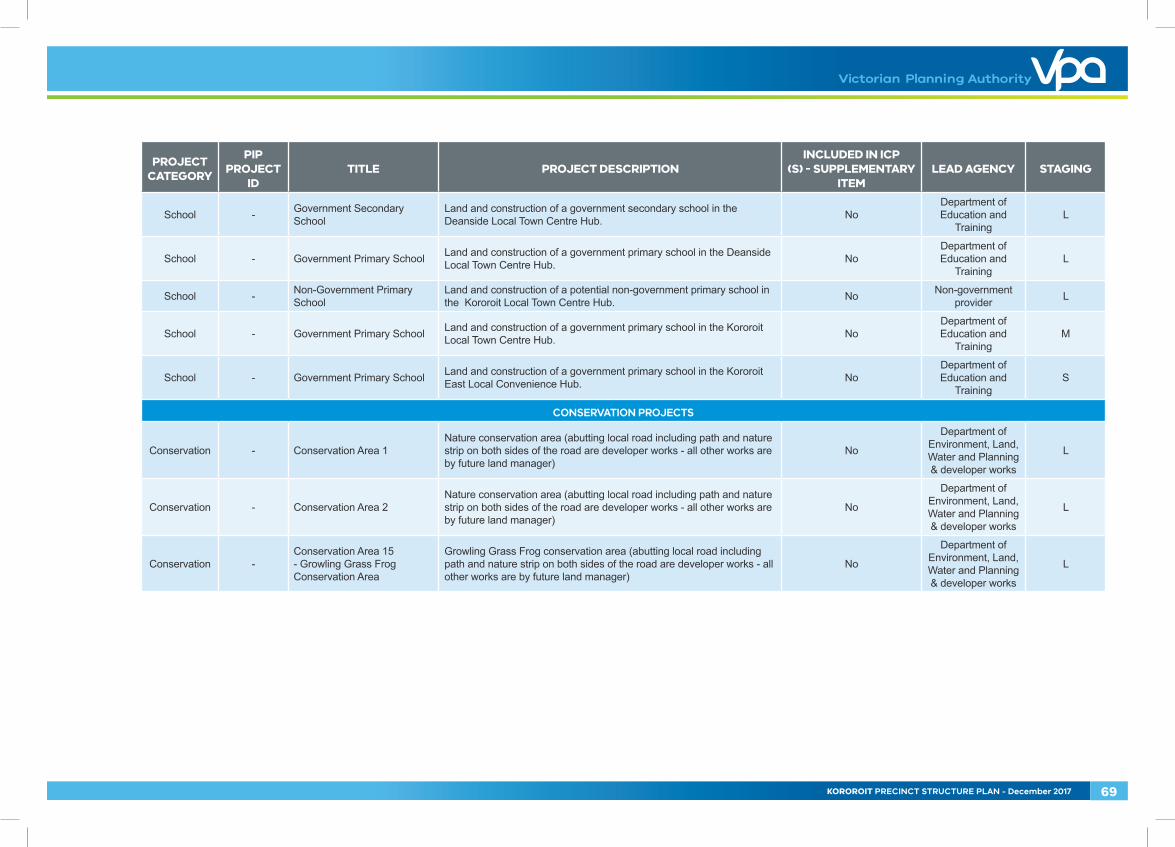
School - Government Secondary School
Land and construction of a government secondary school in the Deanside Local Town Centre Hub. No
Department of Education and
TrainingL
School - Government Primary School Land and construction of a government primary school in the Deanside Local Town Centre Hub. No
Department of Education and
TrainingL
School - Non-Government Primary School
Land and construction of a potential non-government primary school in the Kororoit Local Town Centre Hub. No Non-government
provider L
School - Government Primary School Land and construction of a government primary school in the Kororoit Local Town Centre Hub. No
Department of Education and
TrainingM
School - Government Primary School Land and construction of a government primary school in the Kororoit East Local Convenience Hub. No
Department of Education and
TrainingS
CONSERVATION PROJECTS
Conservation - Conservation Area 1Nature conservation area (abutting local road including path and nature strip on both sides of the road are developer works - all other works are by future land manager)
No
Department of Environment, Land, Water and Planning & developer works
L
Conservation - Conservation Area 2Nature conservation area (abutting local road including path and nature strip on both sides of the road are developer works - all other works are by future land manager)
No
Department of Environment, Land, Water and Planning & developer works
L
Conservation -Conservation Area 15 - Growling Grass Frog Conservation Area
Growling Grass Frog conservation area (abutting local road including path and nature strip on both sides of the road are developer works - all other works are by future land manager)
No
Department of Environment, Land, Water and Planning & developer works
L
KOROROIT PRECINCT STRUCTURE PLAN - December 2017 69
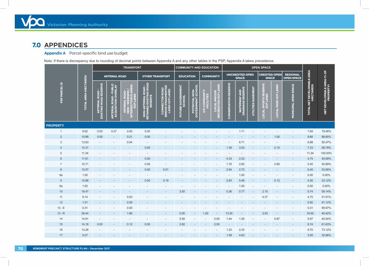
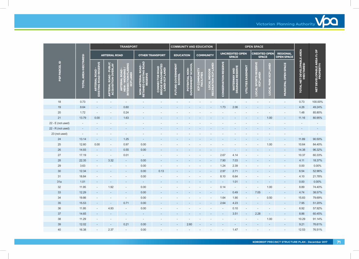
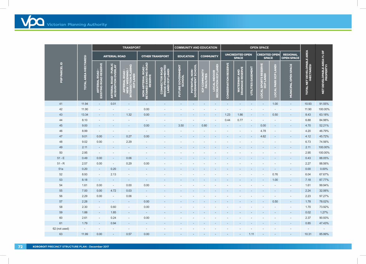
7.0 APPENDICES Appendix A Parcel-specific land use budget
Note; If there is discrepancy due to rounding of decimal points between Appendix A and any other tables in the PSP, Appendix A takes precedence. P
SP
PA
RC
EL
ID
TO
TAL
AR
EA
(HE
CTA
RE
S)
TRANSPORT COMMUNITY AND EDUCATION OPEN SPACE
TO
TAL
NE
T D
EV
ELO
PAB
LE A
RE
A
(HE
CTA
RE
S)
NE
T D
EV
ELO
PAB
LE A
RE
A (%
OF
P
RO
PE
RT
Y)
ARTERIAL ROAD OTHER TRANSPORT EDUCATION COMMUNITY UNCREDITED OPEN SPACE
CREDITED OPEN SPACE
REGIONAL OPEN SPACE
AR
TE
RIA
L R
OA
D -
E
XIS
TIN
G R
OA
D R
ES
ER
VE
AR
TE
RIA
L R
OA
D -
PU
BLI
C
AC
QU
ISIT
ION
OV
ER
LAY
AR
TE
RIA
L R
OA
D -
N
EW
/ W
IDE
NIN
G /
IN
TE
RS
ECT
ION
FLA
RIN
G
(ICP
LA
ND
)
NO
N-A
RT
ER
IAL
RO
AD
-
RE
TAIN
ED
EX
IST
ING
RO
AD
R
ES
ER
VE
CO
NN
EC
TO
R R
OA
D
BR
IDG
E (F
RA
GM
EN
TE
D
LAN
D) (
ICP
LA
ND
)
FUT
UR
E G
OV
ER
NM
EN
T
SC
HO
OL
PO
TE
NT
IAL
NO
N-
GO
VE
RN
ME
NT
SC
HO
OL
ICP
CO
MM
UN
ITY
FA
CIL
ITIE
S
LOC
AL
IND
OO
R
RE
CR
EA
TIO
N (I
CP
LA
ND
)
CO
NS
ER
VA
TIO
N R
ES
ER
VE
WA
TE
RW
AY A
ND
D
RA
INA
GE
RE
SE
RV
E
UT
ILIT
IES
EA
SE
ME
NT
LOC
AL
SP
OR
TS
RE
SE
RV
E
(IC
P L
AN
D)
LOC
AL
PAR
K (I
CP
LA
ND
)
MU
NIC
IPA
L O
PE
N S
PAC
E
PROPERTY
1 9.62 0.00 0.27 0.00 0.00 - - - - - - 1.71 - - - - 7.64 79.46%
2 10.88 0.00 - 0.21 0.00 - - - - - - - - - 1.00 - 9.66 88.85%
3 13.63 - - 0.04 - - - - - - - 6.71 - - - - 6.88 50.47%
4 12.31 - - - 0.00 - - - - - 1.39 3.53 - - 0.15 - 7.23 58.78%
5 11.34 - - - - - - - - - - - - - - - 11.34 100.00%
6 11.61 - - - 0.00 - - - - - 4.33 2.53 - - - - 4.75 40.89%
7 10.71 - - - 0.00 - - - - - 1.76 2.65 - - 0.85 - 5.45 50.89%
8 12.07 - - - 0.00 0.01 - - - - 2.94 2.72 - - - - 6.40 53.06%
8a 1.00 - - - - - - - - - - 1.00 - - - - 0.00 0.00%
9 12.86 - - - 0.00 0.19 - - - - 2.83 5.46 - - 0.12 - 4.26 33.12%
9a 1.93 - - - - - - - - - - 1.93 - - - - 0.00 0.00%
10 16.47 - - - - - 3.50 - - - 0.36 0.77 - 2.10 - - 9.74 59.14%
11 9.14 - - 0.03 - - - - - - - - - 4.37 - - 4.75 51.91%
12 1.01 - - 0.09 - - - - - - - - - - - - 0.92 91.12%
13 - E 0.31 - - 0.00 - - - - - - - - - - - - 0.31 99.97%
13 - R 36.44 - - 1.86 - - 0.00 - 1.20 - 13.30 - - 3.53 - - 16.55 45.42%
14 14.91 - - - - - 5.58 - - 0.00 1.44 1.05 - - 0.87 - 5.97 40.04%
15 14.18 0.00 - 0.12 0.00 - 2.82 - - 2.50 - - - - - - 8.74 61.63%
16 13.26 - - - - - - - - - 1.23 2.33 - - - - 9.70 73.12%
17 9.27 - - - - - - - - - 1.59 4.63 - - - - 3.05 32.86%
70 KOROROIT PRECINCT STRUCTURE PLAN - December 2017
PS
P P
AR
CE
L ID
TO
TAL
AR
EA
(HE
CTA
RE
S)
TRANSPORT COMMUNITY AND EDUCATION OPEN SPACE
TO
TAL
NE
T D
EV
ELO
PAB
LE A
RE
A
(HE
CTA
RE
S)
NE
T D
EV
ELO
PAB
LE A
RE
A (%
OF
P
RO
PE
RT
Y)
ARTERIAL ROAD OTHER TRANSPORT EDUCATION COMMUNITY UNCREDITED OPEN SPACE
CREDITED OPEN SPACE
REGIONAL OPEN SPACE
AR
TE
RIA
L R
OA
D -
E
XIS
TIN
G R
OA
D R
ES
ER
VE
AR
TE
RIA
L R
OA
D -
PU
BLI
C
AC
QU
ISIT
ION
OV
ER
LAY
AR
TE
RIA
L R
OA
D -
N
EW
/ W
IDE
NIN
G /
IN
TE
RS
ECT
ION
FLA
RIN
G
(ICP
LA
ND
)
NO
N-A
RT
ER
IAL
RO
AD
-
RE
TAIN
ED
EX
IST
ING
RO
AD
R
ES
ER
VE
CO
NN
EC
TO
R R
OA
D
BR
IDG
E (F
RA
GM
EN
TE
D
LAN
D) (
ICP
LA
ND
)
FUT
UR
E G
OV
ER
NM
EN
T
SC
HO
OL
PO
TE
NT
IAL
NO
N-
GO
VE
RN
ME
NT
SC
HO
OL
ICP
CO
MM
UN
ITY
FA
CIL
ITIE
S
LOC
AL
IND
OO
R
RE
CR
EA
TIO
N (I
CP
LA
ND
)
CO
NS
ER
VA
TIO
N R
ES
ER
VE
WA
TE
RW
AY A
ND
D
RA
INA
GE
RE
SE
RV
E
UT
ILIT
IES
EA
SE
ME
NT
LOC
AL
SP
OR
TS
RE
SE
RV
E
(IC
P L
AN
D)
LOC
AL
PAR
K (I
CP
LA
ND
)
MU
NIC
IPA
L O
PE
N S
PAC
E
18 0.73 - - - - - - - - - - - - - - - 0.73 100.00%
19 8.64 - - 0.60 - - - - - - 1.73 2.06 - - - - 4.26 49.24%
20 1.72 - - 0.24 - - - - - - - - - - - - 1.48 85.80%
21 13.79 0.00 - 1.63 - - - - - - - - - - 1.00 - 11.16 80.95%
22 - E (not used) - - - - - - - - - - - - - - - - - -
22 - R (not used) - - - - - - - - - - - - - - - - - -
23 (not used) - - - - - - - - - - - - - - - - - -
24 13.14 - - 1.25 - - - - - - - - - - - - 11.89 90.50%
25 12.60 0.00 - 0.97 0.00 - - - - - - - - - 1.00 - 10.64 84.40%
26 14.93 - - 0.55 0.00 - - - - - - - - - - - 14.38 96.32%
27 17.19 - - 0.01 - - - - - - 2.67 4.14 - - - - 10.37 60.33%
28 22.35 - 3.32 - 0.00 - - - - - 7.90 7.03 - - - - 4.11 18.37%
29 3.63 - - - 0.00 - - - - - 1.24 2.39 - - - - 0.00 0.00%
30 12.34 - - - 0.00 0.13 - - - - 2.97 2.71 - - - - 6.54 52.96%
31 18.84 - - - 0.00 - - - - - 8.10 6.64 - - - - 4.10 21.78%
31a 1.01 - - - - - - - - - - 1.01 - - - - 0.00 0.00%
32 11.95 - 1.92 - 0.00 - - - - - 0.14 - - - 1.00 - 8.89 74.40%
33 12.29 - - - 0.00 - - - - - - 0.49 - 7.05 - - 4.74 38.57%
34 19.86 - - - 0.00 - - - - - 1.64 1.90 - - 0.50 - 15.83 79.69%
35 15.53 - - 0.71 0.00 - - - - - 2.64 4.23 - - - - 7.95 51.20%
36 11.95 - 4.93 - 0.00 - - - - - - 0.10 - - - - 6.92 57.92%
37 14.65 - - - - - - - - - - 3.51 - 2.28 - - 8.86 60.45%
38 11.29 - - - - - - - - - - - - - 1.00 - 10.29 91.14%
39 12.02 - - 0.21 0.00 - - 2.60 - - - - - - - - 9.21 76.61%
40 16.38 - 2.37 - 0.00 - - - - - - 1.47 - - - - 12.53 76.51%
KOROROIT PRECINCT STRUCTURE PLAN - December 2017 71
PS
P P
AR
CE
L ID
TO
TAL
AR
EA
(HE
CTA
RE
S)
TRANSPORT COMMUNITY AND EDUCATION OPEN SPACE
TO
TAL
NE
T D
EV
ELO
PAB
LE A
RE
A
(HE
CTA
RE
S)
NE
T D
EV
ELO
PAB
LE A
RE
A (%
OF
P
RO
PE
RT
Y)
ARTERIAL ROAD OTHER TRANSPORT EDUCATION COMMUNITY UNCREDITED OPEN SPACE
CREDITED OPEN SPACE
REGIONAL OPEN SPACE
AR
TE
RIA
L R
OA
D -
E
XIS
TIN
G R
OA
D R
ES
ER
VE
AR
TE
RIA
L R
OA
D -
PU
BLI
C
AC
QU
ISIT
ION
OV
ER
LAY
AR
TE
RIA
L R
OA
D -
N
EW
/ W
IDE
NIN
G /
IN
TE
RS
ECT
ION
FLA
RIN
G
(ICP
LA
ND
)
NO
N-A
RT
ER
IAL
RO
AD
-
RE
TAIN
ED
EX
IST
ING
RO
AD
R
ES
ER
VE
CO
NN
EC
TO
R R
OA
D
BR
IDG
E (F
RA
GM
EN
TE
D
LAN
D) (
ICP
LA
ND
)
FUT
UR
E G
OV
ER
NM
EN
T
SC
HO
OL
PO
TE
NT
IAL
NO
N-
GO
VE
RN
ME
NT
SC
HO
OL
ICP
CO
MM
UN
ITY
FA
CIL
ITIE
S
LOC
AL
IND
OO
R
RE
CR
EA
TIO
N (I
CP
LA
ND
)
CO
NS
ER
VA
TIO
N R
ES
ER
VE
WA
TE
RW
AY A
ND
D
RA
INA
GE
RE
SE
RV
E
UT
ILIT
IES
EA
SE
ME
NT
LOC
AL
SP
OR
TS
RE
SE
RV
E
(IC
P L
AN
D)
LOC
AL
PAR
K (I
CP
LA
ND
)
MU
NIC
IPA
L O
PE
N S
PAC
E
41 11.94 - 0.01 - - - - - - - - - - - 1.00 - 10.93 91.55%
42 11.90 - - - 0.00 - - - - - - - - - - - 11.90 100.00%
43 13.34 - - 1.32 0.00 - - - - - 1.23 1.86 - - 0.50 - 8.43 63.18%
44 8.10 - - - - - - - - - 0.44 0.77 - - - - 6.88 84.98%
45 9.00 - - - 0.00 - 3.50 - 0.80 - - - - 0.00 - - 4.70 52.21%
46 8.99 - - - - - - - - - - - - 4.78 - - 4.20 46.79%
47 9.01 0.00 - 0.27 0.00 - - - - - - - - 4.62 - - 4.12 45.72%
48 9.02 0.00 - 2.29 - - - - - - - - - - - - 6.73 74.56%
49 2.11 - - - - - - - - - - - - - - - 2.11 100.00%
50 2.95 - - - - - - - - - - - - - - - 2.95 100.00%
51 - E 0.49 0.00 - 0.06 - - - - - - - - - - - - 0.43 88.05%
51 - R 2.57 0.00 - 0.29 0.00 - - - - - - - - - - - 2.27 88.56%
51a 0.20 - 0.20 - - - - - - - - - - - - - 0.00 0.00%
52 8.93 - 2.13 - - - - - - - - - - - 0.76 - 6.04 67.67%
53 8.18 - - - - - - - - - - - - - 1.00 - 7.18 87.77%
54 1.61 0.00 - 0.00 0.00 - - - - - - - - - - - 1.61 99.94%
55 7.00 0.00 4.72 0.03 - - - - - - - - - - - - 2.24 32.06%
56 2.29 0.00 - 0.06 - - - - - - - - - - - - 2.23 97.27%
57 2.28 - - - 0.00 - - - - - - - - - 0.50 - 1.78 78.02%
58 2.30 - 0.60 - 0.00 - - - - - - - - - - - 1.70 73.92%
59 1.88 - 1.85 - - - - - - - - - - - - - 0.02 1.27%
60 2.61 - 0.24 - 0.00 - - - - - - - - - - - 2.37 90.93%
61 1.79 - 0.94 - - - - - - - - - - - - - 0.85 47.43%
62 (not used) - - - - - - - - - - - - - - - - - -
63 11.99 0.00 - 0.57 0.00 - - - - - - - 1.11 - - - 10.31 85.99%
72 KOROROIT PRECINCT STRUCTURE PLAN - December 2017
PS
P P
AR
CE
L ID
TO
TAL
AR
EA
(HE
CTA
RE
S)
TRANSPORT COMMUNITY AND EDUCATION OPEN SPACE
TO
TAL
NE
T D
EV
ELO
PAB
LE A
RE
A
(HE
CTA
RE
S)
NE
T D
EV
ELO
PAB
LE A
RE
A (%
OF
P
RO
PE
RT
Y)
ARTERIAL ROAD OTHER TRANSPORT EDUCATION COMMUNITY UNCREDITED OPEN SPACE
CREDITED OPEN SPACE
REGIONAL OPEN SPACE
AR
TE
RIA
L R
OA
D -
E
XIS
TIN
G R
OA
D R
ES
ER
VE
AR
TE
RIA
L R
OA
D -
PU
BLI
C
AC
QU
ISIT
ION
OV
ER
LAY
AR
TE
RIA
L R
OA
D -
N
EW
/ W
IDE
NIN
G /
IN
TE
RS
ECT
ION
FLA
RIN
G
(ICP
LA
ND
)
NO
N-A
RT
ER
IAL
RO
AD
-
RE
TAIN
ED
EX
IST
ING
RO
AD
R
ES
ER
VE
CO
NN
EC
TO
R R
OA
D
BR
IDG
E (F
RA
GM
EN
TE
D
LAN
D) (
ICP
LA
ND
)
FUT
UR
E G
OV
ER
NM
EN
T
SC
HO
OL
PO
TE
NT
IAL
NO
N-
GO
VE
RN
ME
NT
SC
HO
OL
ICP
CO
MM
UN
ITY
FA
CIL
ITIE
S
LOC
AL
IND
OO
R
RE
CR
EA
TIO
N (I
CP
LA
ND
)
CO
NS
ER
VA
TIO
N R
ES
ER
VE
WA
TE
RW
AY A
ND
D
RA
INA
GE
RE
SE
RV
E
UT
ILIT
IES
EA
SE
ME
NT
LOC
AL
SP
OR
TS
RE
SE
RV
E
(IC
P L
AN
D)
LOC
AL
PAR
K (I
CP
LA
ND
)
MU
NIC
IPA
L O
PE
N S
PAC
E
64 11.98 0.00 - 0.38 - - - - - - - 0.96 - - 1.00 - 9.65 80.49%
65 16.46 - - - 0.00 - - - - - - 2.45 0.72 - 1.23 - 12.06 73.27%
66 29.95 - - - 0.00 - - - - - 1.54 3.74 1.39 - 0.55 - 22.73 75.90%
66a 1.73 0.00 - 0.03 - - - - - - 0.07 0.48 - - 0.07 - 1.09 62.98%
67 66.00 0.00 - 0.98 - - - - - - 43.75 5.31 2.60 - - - 13.37 20.25%
67a 1.40 - - - - - - - - - - 1.40 - - - - 0.00 0.00%
68 67.42 0.00 - 0.52 - - - - - - 1.96 12.74 11.18 3.80 1.30 - 35.92 53.28%
69 64.17 0.00 - 0.72 0.00 - 3.50 - 0.80 - 3.14 7.02 - 2.20 1.19 - 45.61 71.07%
70 4.08 - - - - - - - - - 1.21 1.43 - - 0.00 1.44 0.00 0.00%
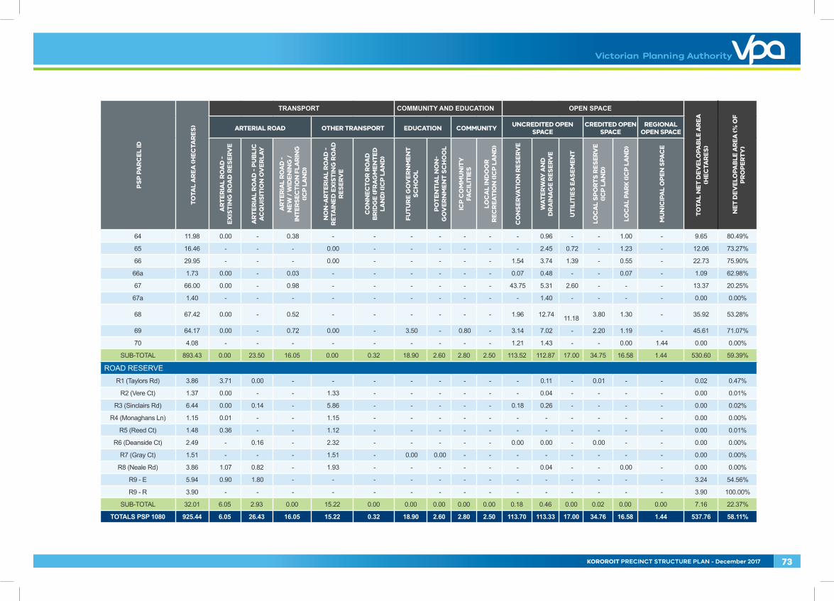
SUB-TOTAL 893.43 0.00 23.50 16.05 0.00 0.32 18.90 2.60 2.80 2.50 113.52 112.87 17.00 34.75 16.58 1.44 530.60 59.39%
ROAD RESERVER1 (Taylors Rd) 3.86 3.71 0.00 - - - - - - - - 0.11 - 0.01 - - 0.02 0.47%
R2 (Vere Ct) 1.37 0.00 - - 1.33 - - - - - - 0.04 - - - - 0.00 0.01%
R3 (Sinclairs Rd) 6.44 0.00 0.14 - 5.86 - - - - - 0.18 0.26 - - - - 0.00 0.02%
R4 (Monaghans Ln) 1.15 0.01 - - 1.15 - - - - - - - - - - - 0.00 0.00%
R5 (Reed Ct) 1.48 0.36 - - 1.12 - - - - - - - - - - - 0.00 0.01%
R6 (Deanside Ct) 2.49 - 0.16 - 2.32 - - - - - 0.00 0.00 - 0.00 - - 0.00 0.00%
R7 (Gray Ct) 1.51 - - - 1.51 - 0.00 0.00 - - - - - - - - 0.00 0.00%
R8 (Neale Rd) 3.86 1.07 0.82 - 1.93 - - - - - - 0.04 - - 0.00 - 0.00 0.00%
R9 - E 5.94 0.90 1.80 - - - - - - - - - - - - - 3.24 54.56%
R9 - R 3.90 - - - - - - - - - - - - - - - 3.90 100.00%
SUB-TOTAL 32.01 6.05 2.93 0.00 15.22 0.00 0.00 0.00 0.00 0.00 0.18 0.46 0.00 0.02 0.00 0.00 7.16 22.37%
TOTALS PSP 1080 925.44 6.05 26.43 16.05 15.22 0.32 18.90 2.60 2.80 2.50 113.70 113.33 17.00 34.76 16.58 1.44 537.76 58.11%
KOROROIT PRECINCT STRUCTURE PLAN - December 2017 73
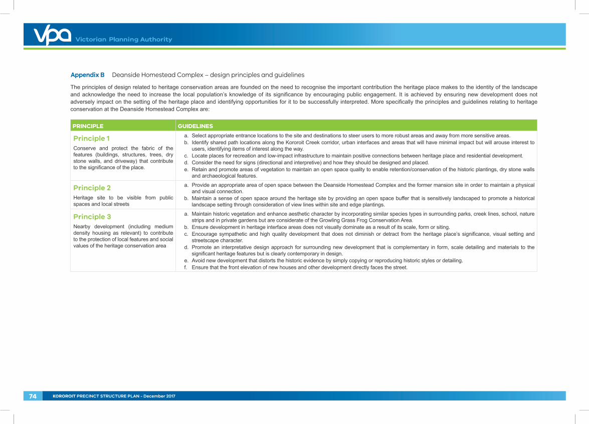
Appendix B Deanside Homestead Complex – design principles and guidelines
The principles of design related to heritage conservation areas are founded on the need to recognise the important contribution the heritage place makes to the identity of the landscape and acknowledge the need to increase the local population’s knowledge of its significance by encouraging public engagement. It is achieved by ensuring new development does not adversely impact on the setting of the heritage place and identifying opportunities for it to be successfully interpreted. More specifically the principles and guidelines relating to heritage conservation at the Deanside Homestead Complex are:
PRINCIPLE GUIDELINES
Principle 1Conserve and protect the fabric of the features (buildings, structures, trees, dry stone walls, and driveway) that contribute to the significance of the place.
a. Select appropriate entrance locations to the site and destinations to steer users to more robust areas and away from more sensitive areas.b. Identify shared path locations along the Kororoit Creek corridor, urban interfaces and areas that will have minimal impact but will arouse interest to
users, identifying items of interest along the way.c. Locate places for recreation and low-impact infrastructure to maintain positive connections between heritage place and residential development.d. Consider the need for signs (directional and interpretive) and how they should be designed and placed.e. Retain and promote areas of vegetation to maintain an open space quality to enable retention/conservation of the historic plantings, dry stone walls
and archaeological features.
Principle 2Heritage site to be visible from public spaces and local streets
a. Provide an appropriate area of open space between the Deanside Homestead Complex and the former mansion site in order to maintain a physical and visual connection.
b. Maintain a sense of open space around the heritage site by providing an open space buffer that is sensitively landscaped to promote a historical landscape setting through consideration of view lines within site and edge plantings.
Principle 3Nearby development (including medium density housing as relevant) to contribute to the protection of local features and social values of the heritage conservation area
a. Maintain historic vegetation and enhance aesthetic character by incorporating similar species types in surrounding parks, creek lines, school, nature strips and in private gardens but are considerate of the Growling Grass Frog Conservation Area.
b. Ensure development in heritage interface areas does not visually dominate as a result of its scale, form or siting. c. Encourage sympathetic and high quality development that does not diminish or detract from the heritage place’s significance, visual setting and
streetscape character.d. Promote an interpretative design approach for surrounding new development that is complementary in form, scale detailing and materials to the
significant heritage features but is clearly contemporary in design.e. Avoid new development that distorts the historic evidence by simply copying or reproducing historic styles or detailing.f. Ensure that the front elevation of new houses and other development directly faces the street.
74 KOROROIT PRECINCT STRUCTURE PLAN - December 2017

Appendix C Local Town Centre guidelines
PRINCIPLE GUIDELINES
Principle 1Provide every neighbourhood with a viable Local Town Centre as a focus of the community with a fine-grained, closely spaced distribution pattern.
• Deliver a fine-grained distribution pattern of highly accessible Local Town Centres generally on a scale of one Local Town Centre for every neighbourhood of 8,000 to 10,000 people
• Locate Local Town Centres with a distribution pattern of around one Local Town Centre for every square mile (2.58km2) of residential development
• Deliver a network of economically viable Local Town Centres including a supermarket and supporting competitive local shopping business, medical, leisure, recreation and community needs while allowing opportunities for local specialisation.
Principle 2Locate Local Town Centres on a connector street intersection with access to an arterial road and transit stop.
• Locate the Local Town Centre on or with close proximity to an arterial/connector intersection and ensure that the Local Town Centre is central to the residential catchment that it services while optimising opportunities for passing trade
• Locate forms of transit stops to benefit the Local Town Centre and to offer convenience for public transport passengers• Other Local Town Centre locations may be considered where the location results in the Local Town Centre being central to the
residential catchment that it serves and/or the location incorporates natural or cultural landscape features such as rivers and creeks, tree rows, topographic features or other heritage structures which assist in creating a sense of place.
Principle 3Locate Local Town Centres in an attractive setting so that most people live within a walkable catchment of a Local Town Centre and relate to the centre as the focus of the neighbourhood.
• Ensure that 80-90% of households are within a 1km walkable catchment of a local or higher order Town Centre• Locate Local Town Centres in attractive settings and incorporate natural or cultural landscape features such creeks and waterways,
linear open space, pedestrian and cycle links and areas of high aesthetic value• The design of the Local Town Centre should respect/enhance existing views and vistas to and from the Local Town Centre location.
KOROROIT PRECINCT STRUCTURE PLAN - December 2017 75
PRINCIPLE GUIDELINES
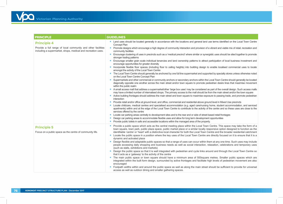
Principle 4Provide a full range of local community and other facilities including a supermarket, shops, medical and recreation uses.
• Land uses should be located generally in accordance with the locations and general land use terms identified on the Local Town Centre Concept Plan
• Promote designs which encourage a high degree of community interaction and provision of a vibrant and viable mix of retail, recreation and community facilities
• Encourage clustering of uses in precincts such as a ‘medical precinct’ where similar or synergistic uses should be sited together to promote stronger trading patterns
• Encourage smaller grain scale individual tenancies and land ownership patterns to attract participation of local business investment and encourage opportunities for greater diversity
• Incorporate flexible floor spaces (including floor to ceiling heights) into building design to enable localised commercial uses to locate amongst the activity of the Local Town Centre
• The Local Town Centre should generally be anchored by one full line supermarket and supported by specialty stores unless otherwise noted on the Local Town Centre Concept Plan
• Supermarkets and other commercial or community anchors or secondary anchors within the Local Town Centre should generally be located diagonally opposite one another across the main street and/or town square to promote pedestrian desire lines that maximise movement within the public realm
• A small access mall that address a supermarket/other ‘large box uses’ may be considered as part of the overall design. Such access malls may have a limited number of internalised shops. The primary access to the mall should be from the main street and/or the town square
• Active building frontages should address the main street and town square to maximise exposure to passing trade, and promote pedestrian interaction
• Provide retail and/or office at ground level, and office, commercial and residential above ground level in Mixed Use precincts • Locate childcare, medical centres and specialised accommodation (e.g. aged care/nursing home, student accommodation, and serviced
apartments) within and at the edge of the Local Town Centre to contribute to the activity of the centre and so these uses are close to the services offered by the centre
• Locate car parking areas centrally to development sites and to the rear and or side of street based retail frontages• Design car parking areas to accommodate flexible uses and allow for long term development opportunities• Provide public toilets in safe and accessible locations within the managed area of the property.
Principle 5Focus on a public space as the centre of community life.
• Provide a public space which acts as the central meeting place within the Local Town Centre. This space may take the form of a town square, town park, public plaza space, public market place or a similar locally responsive option designed to function as the identifiable ‘centre’ or ‘heart’ with a distinctive local character for both the Local Town Centre and the broader residential catchment
• Locate the public space in a position where the key uses of the Local Town Centre are directly focused on it to ensure that it is a dynamic and activated place
• Design flexible and adaptable public spaces so that a range of uses can occur within them at any one time. Such uses may include people accessing daily shopping and business needs as well as social interaction, relaxation, celebrations and temporary uses (such as stalls, exhibitions and markets)
• Design the public space so that it is well integrated with pedestrian and cycle links around and through the Local Town Centre so that it acts as a ‘gateway’ to the activity of the centre
• The main public space or town square should have a minimum area of 500square metres. Smaller public spaces which are integrated within the built form design, surrounded by active frontages and facilitate high levels of pedestrian movement are also encouraged
• Footpath widths within and around the public space as well as along the main street should be sufficient to provide for universal access as well as outdoor dining and smaller gathering spaces.
76 KOROROIT PRECINCT STRUCTURE PLAN - December 2017
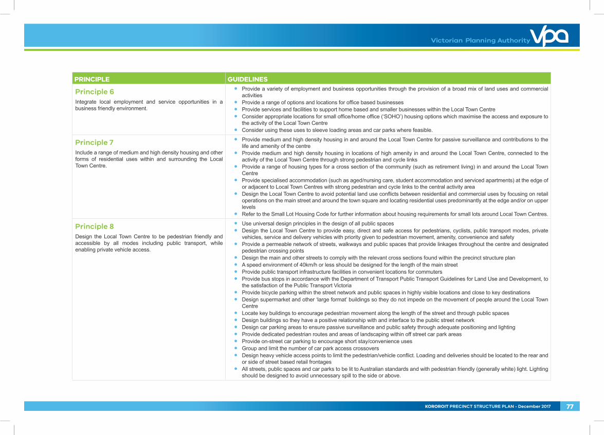
PRINCIPLE GUIDELINES
Principle 6Integrate local employment and service opportunities in a business friendly environment.
• Provide a variety of employment and business opportunities through the provision of a broad mix of land uses and commercial activities
• Provide a range of options and locations for office based businesses• Provide services and facilities to support home based and smaller businesses within the Local Town Centre• Consider appropriate locations for small office/home office (‘SOHO’) housing options which maximise the access and exposure to
the activity of the Local Town Centre• Consider using these uses to sleeve loading areas and car parks where feasible.
Principle 7Include a range of medium and high density housing and other forms of residential uses within and surrounding the Local Town Centre.
• Provide medium and high density housing in and around the Local Town Centre for passive surveillance and contributions to the life and amenity of the centre
• Provide medium and high density housing in locations of high amenity in and around the Local Town Centre, connected to the activity of the Local Town Centre through strong pedestrian and cycle links
• Provide a range of housing types for a cross section of the community (such as retirement living) in and around the Local Town Centre
• Provide specialised accommodation (such as aged/nursing care, student accommodation and serviced apartments) at the edge of or adjacent to Local Town Centres with strong pedestrian and cycle links to the central activity area
• Design the Local Town Centre to avoid potential land use conflicts between residential and commercial uses by focusing on retail operations on the main street and around the town square and locating residential uses predominantly at the edge and/or on upper levels
• Refer to the Small Lot Housing Code for further information about housing requirements for small lots around Local Town Centres.
Principle 8Design the Local Town Centre to be pedestrian friendly and accessible by all modes including public transport, while enabling private vehicle access.
• Use universal design principles in the design of all public spaces• Design the Local Town Centre to provide easy, direct and safe access for pedestrians, cyclists, public transport modes, private
vehicles, service and delivery vehicles with priority given to pedestrian movement, amenity, convenience and safety• Provide a permeable network of streets, walkways and public spaces that provide linkages throughout the centre and designated
pedestrian crossing points• Design the main and other streets to comply with the relevant cross sections found within the precinct structure plan• A speed environment of 40km/h or less should be designed for the length of the main street• Provide public transport infrastructure facilities in convenient locations for commuters• Provide bus stops in accordance with the Department of Transport Public Transport Guidelines for Land Use and Development, to
the satisfaction of the Public Transport Victoria• Provide bicycle parking within the street network and public spaces in highly visible locations and close to key destinations• Design supermarket and other ‘large format’ buildings so they do not impede on the movement of people around the Local Town
Centre• Locate key buildings to encourage pedestrian movement along the length of the street and through public spaces• Design buildings so they have a positive relationship with and interface to the public street network• Design car parking areas to ensure passive surveillance and public safety through adequate positioning and lighting• Provide dedicated pedestrian routes and areas of landscaping within off street car park areas• Provide on-street car parking to encourage short stay/convenience uses• Group and limit the number of car park access crossovers• Design heavy vehicle access points to limit the pedestrian/vehicle conflict. Loading and deliveries should be located to the rear and
or side of street based retail frontages• All streets, public spaces and car parks to be lit to Australian standards and with pedestrian friendly (generally white) light. Lighting
should be designed to avoid unnecessary spill to the side or above.
KOROROIT PRECINCT STRUCTURE PLAN - December 2017 77
PRINCIPLE GUIDELINES
Principle 9Create a sense of place with high quality engaging urban design
• Design development to complement and enhance the character of the surrounding area by responding to key visual cues associated with the topography and other natural features of the Local Town Centre location and its surrounds
• Minimise amenity and noise impacts resulting from the mix of uses by maintaining appropriate separation and transitional areas between retail and housing activities using open space, road networks and community facilities
• Design each building to contribute to a cohesive and legible character for the Local Town Centre as a whole• Designate sites in prominent locations (such as at key intersections, surrounding public spaces and terminating key view lines and
vistas) for significant buildings or landmark structures• Design corner sites, where the main street meets an intersecting and/or arterial road to:
• Provide built form that anchors the main street to the intersecting road. This can be achieved through increased building height, scale and articulated frontages
• Incorporate either 2 storey building or 2 storey elements (such as awnings and roof lines)• Provide an active ground floor frontage and active floor space component to the main street frontage; and
• Provide a consistent covered walkway or verandah for weather protection in the design of building frontages on major pedestrian routes• Align built form with the property boundary to define the street edge• Provide visually rich, interesting and well articulated street facing facades and all visible side or rear facades finished in suitable
materials and colours that contribute to the character of the Local Town Centre• Use materials and design elements which are compatible with the environment and landscape character of the broader precinct• The design and siting of supermarkets and other ‘large format retail uses’ should provide an appropriate response to the entire
public domain. This includes but is not limited to car parking areas, predominantly routes and streets• Design supermarket and secondary anchors with frontages that directly address the main street and/or town square so that the
use integrates with and promotes activity within the main street and public spaces/thoroughfares• Design supermarkets or large format retail uses with a direct frontage to the main street using clear glazing to allow view lines into
the store from the street. (Planning permits for buildings and works should condition against the use of white washed or frosted glass windows, excessive window advertising and obtrusive internal shelving or ‘false walls’ offset from the glazing)
• Secondary access to the supermarket from car parking areas should only be considered where it facilitates convenient trolley access and does not diminish the role of the primary access from the main street and or town square
• Retail uses along street frontages should generally include access points at regular intervals to encourage activity along the length of the street
• Retail and commercial buildings within the Local Town Centre should generally be built to the property line• Public spaces should be oriented to capture north sun and protect from prevailing winds and weather• Landscaping of all interface areas should be of a high standard as an important element to complement the built form design.• Urban art should be incorporated into the design of the public realm• Street furniture should be located in areas that are highly visible and close to or adjoining pedestrian desire lines/gathering spaces
and designed to add visual interest to the Local Town Centre• Wrapping or sleeving of car parking edges with built form, to improve street interface, should be maximised• Car parking areas should provide for appropriate landscaping with planting of canopy trees and dedicated pedestrian thoroughfares• Screening of centralised waste collection points should minimise amenity impacts on adjoining areas and users of the centre• Where service areas are accessible from car parks, they should present a well-designed and secure facade to public areas• Mechanical plant and service structure roofs should be included within roof lines or otherwise hidden from view.
78 KOROROIT PRECINCT STRUCTURE PLAN - December 2017
PRINCIPLE GUIDELINES
Principle 10Promote localisation, sustainability and adaptability.
• The Local Town Centre should promote the localisation of services which will contribute to a reduction of travel distance to access local services and less dependence on private vehicles
• The Local Town Centre should be designed to be sympathetic to its natural surrounds by:• Investigating the use of energy efficient design and construction methods for all buildings• Including Water Sensitive Urban Design principles such as integrated stormwater retention and reuse (e.g. toilet flushing and
landscape irrigation)• Promoting safe and direct accessibility and mobility within and to and from the Local Town Centre• Including options for shade and shelter through a combination of landscape and built form treatments• Ensuring buildings are naturally ventilated to reduce the reliance on plant equipment for heating and cooling• Promoting passive solar orientation in the configuration and distribution of built form and public spaces• Grouping waste collection points to maximise opportunities for recycling and reuse• Promoting solar energy for water and space heating, electricity generation and internal and external lighting; and • Investigating other opportunities for the built form to reduce greenhouse gas emissions associated with the occupation and the
ongoing use of buildings.• Ensure the Local Town Centre and building design has an inbuilt capacity for growth and change to enable adaptation and the
intensification of uses as the needs of the community evolve.
KOROROIT PRECINCT STRUCTURE PLAN - December 2017 79
Appendix D Design principles - conservation areas
These have been adapted from principles in Start with the Grasslands – Design Guidelines to support native grasslands in urban areas (2013) Victorian National Parks Association, and ideas from Melbourne’s Native Grasslands: Guiding Landscapes and Communities in Transition (2015) Royal Botanic Gardens.
These principles acknowledge that in existing and new urban areas, it is generally preferable to encourage appropriate access to conservation areas so that these places are understood and valued by the broader population. Experience has shown that it is in most cases impossible to exclude people from Conservation Areas in the city and suburbs, and that well considered access leads to improved conservation outcomes.
1. Early Planning
EMBED the needs of the grasslands into land-use planning and design processes to ensure they are protected and integrated before, during and after changes to the surrounding environment.
CLARIFY current and future land-ownership, as well as resources and funding for on-going improvements.
ESTABLISH implementation, management, and maintenance agreements between responsible authorities, and neighbouring properties not currently under development.
2. Collaborate
SHARE knowledge between experts, field technicians, traditional landowners, and developers to maximise outcomes for the grasslands.
ENGAGE EARLY with existing and emerging communities, current site users, and local government, to improve perceptions and create a sense of stewardship over the grasslands.
3. Integrate
PROTECT the local features within a development area to retain niches for ecosystem biodiversity.
LOCATE places for recreation and low-impact infrastructure adjacent to grasslands to create and maintain positive connections between the grassland(s) and the everyday activities of the local community.
- HOW TO: A bus stop and/or community facility adjacent to visitor information at the entry to a grassland.
CONNECT the grasslands to the broader landscape and green infrastructure to create new habitat, enhance biodiversity, strengthen open space connections, and create opportunities for the local community to have a sense of ownership of the grasslands.
- HOW TO: Creating a shared path network and habitat corridors which links the grassland not only to other grasslands, but also other types of open space.
4. Maintenance
DESIGN for maintenance with an understanding of site-specific management regimes and long-term resources to retain longevity of the grasslands and the designed spaces within.
Recognise that maintenance resources should be flexible to adapt to varying USE PRESSURES on the grasslands as a result of changes within, and surrounding, the grasslands.
ROUTES around and within the grassland should not impact on high quality grassland areas, and where possible, should but multi-functional and considerate of fire brigade access.
- HOW TO: Creating multi-purpose paths to function as a walking trail, fire break, and for maintenance vehicle access can reduce the amount of disturbances to the grasslands.
MATERIAL selection and placement within and around the grassland should be high quality, considerate of fire, and sensitive to fauna and flora patterns, yet cost effective for long-term maintenance and replacement.
5. Communicate
BRANDING of grasslands, whether in built form or published material, should be considerate of the target audience/s while being portrayed in a positive and cared-for context.
TECHNIQUES which are engaging and informative will help reduce the negative perceptions of grasslands.
- HOW TO: Art installations which can also function as habitat, story-telling to explain the importance of natural and controlled burning of the grasslands, and interpretive signage to explain the changing landscape.
80 KOROROIT PRECINCT STRUCTURE PLAN - December 2017
WEB-based resources and social media should be considered as opportunities to reach a larger audience to inform and educate about the grasslands and associated community events.
In greenfield developments, tools should be available at the point of sale for PROSPECTIVE RESIDENTS to engage people in the experience of grasslands and what they offer to the community.
- HOW TO: Providing information packages, and grassland planting displays in display homes.
6. Encourage Access
INTERFACE TREATMENTS should not only allow the community to be closer to the grasslands upon passing-by, but should also invite them in to discover the grassland.
- HOW TO: Indigenous buffer planting, clear entry points, inviting footpaths, low fencing and engaging signage.
Landscape treatments within the grasslands should be designed to ENCOURAGE PASSIVE RECREATION in and through the areas identified as having low-conservation value, rather than restricting users to the perimeter.
- HOW TO: Providing seating and picnicking areas, and walking tracks for discovery and/or connectivity to the surrounding street network
As grasslands are generally exposed open spaces, designing to create comfortable MICROCLIMATES in response to changing climatic conditions will encourage more passive use of the grasslands.
- HOW TO: Providing shade and wind protection through designing with topography and vegetation.
Promote grassland pockets through encouraging grassland palettes to be INTEGRATED INTO PRIVATE LANDSCAPES, particularly within front setbacks where it can contribute to the public realm.
- HOW TO: Providing residents with information on ‘low maintenance plants for the home’ can include native and indigenous grassland species.
SEEK opportunities to create new grassland areas within new and existing open spaces. Though these areas may not have the complexity of existing remnant grasslands, they allow for greater contact with the community.
- HOW TO: Creating a ‘sensory grassland’ planting theme within and around playspaces encourages natural play while also allowing children and adults to establish a connection with those species.
7. Provide Cues to Care
VISIBLE non-grassland elements associated with the grassland (such as planting, furniture, fencing, buffers, etc.) which are encountered by the public, should show signs of being cared for and valued to help create a positive perception of the grassland.
Cues to Care can occur at a range of SCALES, such as designing a high visibility entrance, to providing access roads to the grassland.
8. Monitor
DETERMINE the effectiveness of early planning processes through to maintenance actions to identify strengths and weaknesses of approach and trigger responsive actions.
IDENTIFY the trajectory of the grassland and observe the change in quality and uses.
UPDATE current information available to the public and stakeholders so they are aware of such changes, and to provide an opportunity for them to understand and be a part of future decisions on the grassland.
KOROROIT PRECINCT STRUCTURE PLAN - December 2017 81
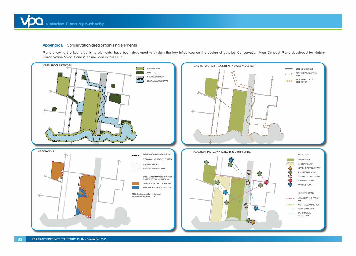
Appendix E Conservation area organising elements
Plans showing the key ‘organising elements’ have been developed to explain the key influences on the design of detailed Conservation Area Concept Plans developed for Nature Conservation Areas 1 and 2, as included in this PSP.
DESTINATION
CONSERVATION
RESIDENTIAL AREA
KOROROIT CREEK GATEWAY
PARK / RESERVE NODE
EASEMENT ACTIVITY NODE
COMMUNITY NODE
DRAINAGE NODE
CONNECTION TYPES
COMMUNITY HUB DESIRE LINE
OPEN SPACE CONNECTION
VISUAL CONNECTION
HYDROLOGICAL CONNECTION
PLACEMAKING: CONNECTIONS & DESIRE LINESVEGETATION
EPBC: Environment Protection and Biodiversity Conservation Act
CONSERVATION AREA BOUNDARY
ECOLOGICAL VEGETATION CLASSES
PLAINS GRASSLAND
PLAINS GRASSY WETLAND
EPBCA-LISTED ‘MATTERS OF NATIONAL ENVIRONMENTAL SIGNIFICANCE’
NATURAL TEMPERATE GRASSLAND
SEASONAL HERBACEOUS WETLAND
CONNECTOR STREET
PSP PEDESTRIAN / CYCLE ROUTE
PEDESTRIAN / CYCLE CONNECTION
ROAD NETWORK & PEDESTRIAN / CYCLE MOVEMENTCONSERVATION
PARK / RESERVE
UTILITIES EASEMENT
DRAINAGE & WATERWAYS
OPEN SPACE NETWORK
82 KOROROIT PRECINCT STRUCTURE PLAN - December 2017
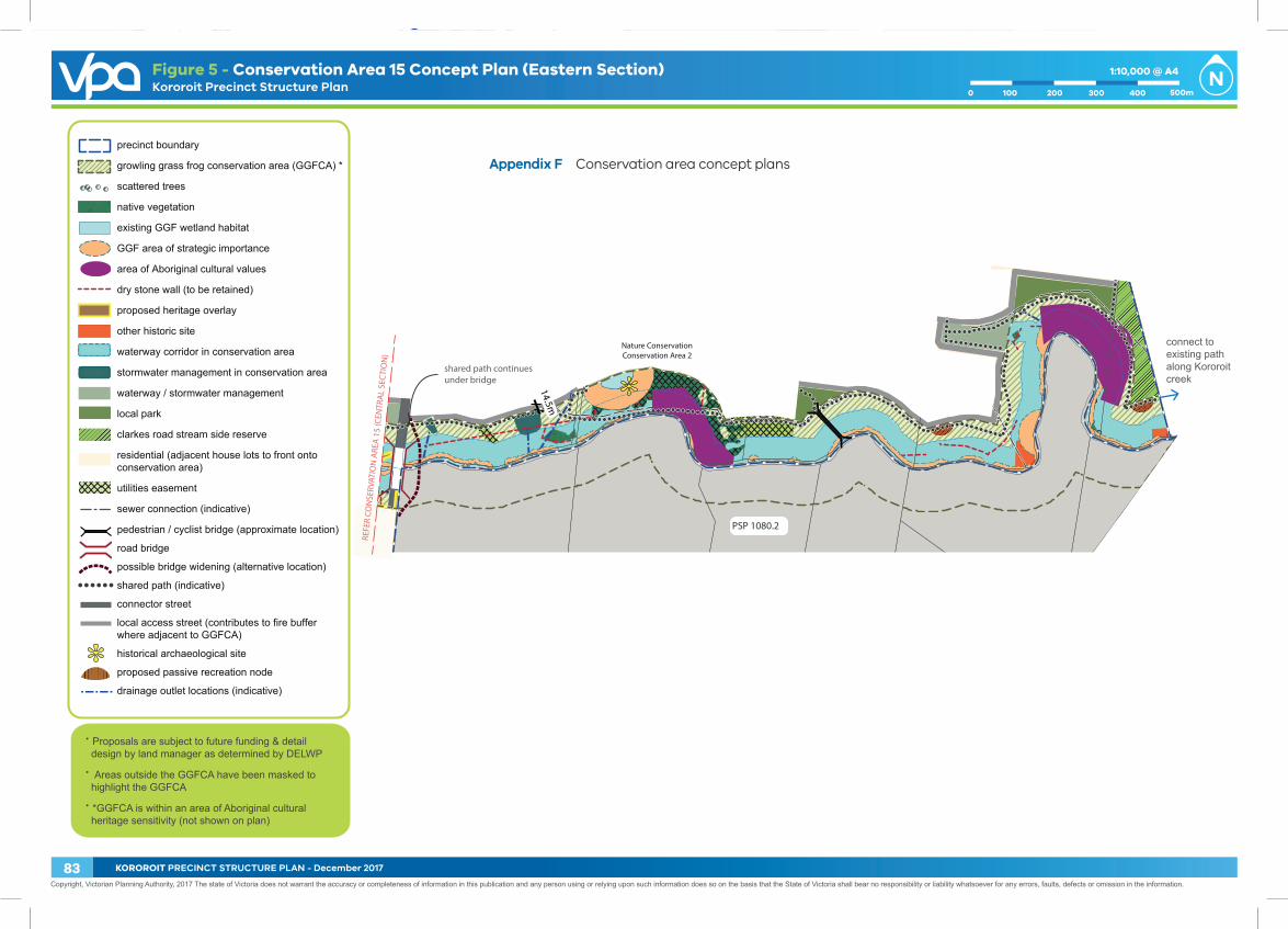
REFE
R CO
NSE
RVAT
ION
ARE
A 1
5 (C
ENTR
AL
SEC
TIO
N)
Nature ConservationConservation Area 2
PSP 1080.2
shared path continues under bridge
connect to existing path along Kororoit creek
14.5m
precinct boundary
growling grass frog conservation area (GGFCA) *
scattered trees
native vegetation
existing GGF wetland habitat
GGF area of strategic importance
area of Aboriginal cultural values
dry stone wall (to be retained)
proposed heritage overlay
other historic site
waterway corridor in conservation area
stormwater management in conservation area
waterway / stormwater management
local park
clarkes road stream side reserve
residential (adjacent house lots to front onto conservation area)
utilities easement
sewer connection (indicative)
pedestrian / cyclist bridge (approximate location)
road bridge
possible bridge widening (alternative location)
shared path (indicative)
connector street
local access street (contributes to fire buffer where adjacent to GGFCA)
historical archaeological site
proposed passive recreation node
drainage outlet locations (indicative)
∙ Proposals are subject to future funding & detail design by land manager as determined by DELWP
∙ Areas outside the GGFCA have been masked to highlight the GGFCA
∙ *GGFCA is within an area of Aboriginal cultural heritage sensitivity (not shown on plan)
Copyright, Victorian Planning Authority, 2017 The state of Victoria does not warrant the accuracy or completeness of information in this publication and any person using or relying upon such information does so on the basis that the State of Victoria shall bear no responsibility or liability whatsoever for any errors, faults, defects or omission in the information.
Kororoit Precinct Structure Plan1:10,000 @ A4
200 3001000 500m400
Geo-ref properties in place. Please don’t move drawing/artboard placement!
Figure 5 - Conservation Area 15 Concept Plan (Eastern Section)
Appendix F Conservation area concept plans
83 KOROROIT PRECINCT STRUCTURE PLAN - December 2017
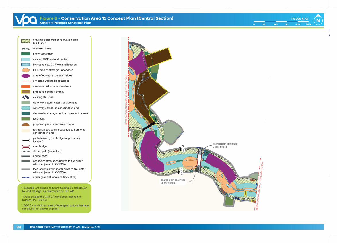
REFE
R CO
NSE
RVAT
ION
ARE
A 1
5 (E
AST
ERN
SEC
TIO
N)
REFE
R CO
NSE
RVAT
ION
ARE
A 1
5 (W
ESTE
RN S
ECTI
ON
)
14.5m14.5m
shared path continues under bridge
shared path continues under bridge
v090516
growling grass frog conservation area (GGFCA) *
scattered trees
native vegetation
existing GGF wetland habitat
indicative new GGF wetland location
GGF area of strategic importance
area of Aboriginal cultural values
dry stone wall (to be retained)
deanside historical access track
proposed heritage overlay
existing structure
waterway / stormwater management
waterway corridor in conservation area
stormwater management in conservation area
local park
proposed passive recreation node
residential (adjacent house lots to front onto conservation area)
pedestrian / cyclist bridge (approximate location)
road bridge
shared path (indicative)
arterial road
connector street (contributes to fire buffer where adjacent to GGFCA)
local access street (contributes to fire buffer where adjacent to GGFCA)
drainage outlet locations (indicative)
∙ Proposals are subject to future funding & detail design by land manager as determined by DELWP
∙ Areas outside the GGFCA have been masked to highlight the GGFCA
∙ *GGFCA is within an area of Aboriginal cultural heritage sensitivity (not shown on plan)
Copyright, Victorian Planning Authority, 2017 The state of Victoria does not warrant the accuracy or completeness of information in this publication and any person using or relying upon such information does so on the basis that the State of Victoria shall bear no responsibility or liability whatsoever for any errors, faults, defects or omission in the information.
Kororoit Precinct Structure Plan
Geo-ref properties in place. Please don’t move drawing/artboard placement!
1:10,000 @ A4
200 3001000 500m400
Figure 6 - Conservation Area 15 Concept Plan (Central Section)
REFE
R CO
NSE
RVAT
ION
ARE
A 1
5 (E
AST
ERN
SEC
TIO
N)
REFE
R CO
NSE
RVAT
ION
ARE
A 1
5 (W
ESTE
RN S
ECTI
ON
)
14.5m14.5m
shared path continues under bridge
shared path continues under bridge
v090516
growling grass frog conservation area (GGFCA) *
scattered trees
native vegetation
existing GGF wetland habitat
indicative new GGF wetland location
GGF area of strategic importance
area of Aboriginal cultural values
dry stone wall (to be retained)
deanside historical access track
proposed heritage overlay
existing structure
waterway / stormwater management
waterway corridor in conservation area
stormwater management in conservation area
local park
proposed passive recreation node
residential (adjacent house lots to front onto conservation area)
pedestrian / cyclist bridge (approximate location)
road bridge
shared path (indicative)
arterial road
connector street (contributes to fire buffer where adjacent to GGFCA)
local access street (contributes to fire buffer where adjacent to GGFCA)
drainage outlet locations (indicative)
∙ Proposals are subject to future funding & detail design by land manager as determined by DELWP
∙ Areas outside the GGFCA have been masked to highlight the GGFCA
∙ *GGFCA is within an area of Aboriginal cultural heritage sensitivity (not shown on plan)
Copyright, Victorian Planning Authority, 2017 The state of Victoria does not warrant the accuracy or completeness of information in this publication and any person using or relying upon such information does so on the basis that the State of Victoria shall bear no responsibility or liability whatsoever for any errors, faults, defects or omission in the information.
Kororoit Precinct Structure Plan
Geo-ref properties in place. Please don’t move drawing/artboard placement!
1:10,000 @ A4
200 3001000 500m400
Figure 6 - Conservation Area 15 Concept Plan (Central Section)
84 KOROROIT PRECINCT STRUCTURE PLAN - December 2017