inquiry into coal seam gas - parliament of nsw
TRANSCRIPT
Supplementary Submission
No 132a
INQUIRY INTO COAL SEAM GAS Organisation: The Colong Foundation for Wilderness Ltd
Name: Mr Keith Muir
Position: Director
Date received: 1/09/2011

Colong Foundation - supplementary submission - BRIEFING PAPER 2002 Enviromental hazards of oil and gas exploration - detailing the impacts arising from coal seam methane exporation by Mike Atkinson, coal and petroleum geologist,

EE NN VV II RR OO NN MM EE NN TT AA LL
HH AA ZZ AA RR DD SS
OO FF
OO II LL AA NN DD GG AA SS EE XX PP LL OO RR AA TT II OO NN
CONTENTS
1. PETROLEUM FORMATION AND COAL SEAM METHANE 1 2. PETROLEUM AND MINERAL EXPLORATION 3 3. COAL SEAM METHANE EXPLORATION 3 4. HAZARDS 3
4.1 Physical damage 4 4.2 Groundwater Problems 4 4.2.1 Groundwater Levels 5 4.2.2 Surface Pollution - Produced Water 6
SALINITY AND SODIC SOILS 6 ORGANIC CHEMICALS 8
5. OIL COMPANIES DETAILS 9 Eastern Star Gas Limited 9 Gastar Exploration, Ltd. 9
6. SELECTED REFERENCES 10
Prepared for: National Parks Association of NSW Inc.
Sydney
C. M. ATKINSON August 2002

O i l & G a s E x p l o r a t i o n H a z a r d s
27 August 2002 2
1. PETROLEUM FORMATION AND COAL SEAM METHANE
A complex mixture of oil, gases and coal are produced when of peat and/or other organic material are compacted and heated by burial over geological time. During this process, methane and more complex hydrocarbons are successively produced. The proportions and type of oil and gas depend on the original type of plant material as well as temperature. Conventional oil and gas fields form when these hydrocarbons migrate into porous rocks and are stored in the spaces between the grains of these reservoir rocks. To keep these mobile gases (and liquids) trapped in place, structural or stratigraphic traps have to be present. The
commonest traps are impermeable rocks which prevent migration of the gas either upwards, or sideways.
This coalification process generates methane-rich gas, large quantities of which normally remain within the coal. This ‘coal seam methane’ gas has been the main cause of disastrous explosions and outbursts in underground coal mines. Coal has only recently been
recognized as a storage or reservoir rock for natural gas as well as a generator or ‘source rock.’
Coal seam Methane (CSM) is actually soaked up by coal grain faces or micropores, and held there by the pressure of water also present in the seam. Methane is also stored in fractures and cleats. The coal seam therefore acts as the source, reservoir and seal for this type of gas deposit. Coal can potentially hold as much as six to seven times more methane per unit of volume than most conventional reservoir rocks. The methane stored can be released by removing most of the water (de-watering) causing a pressure drop which releases the methane from the coal seam. This dewatering is carried out during test pumping and during early stages of production.
The term Petroleum includes: [Crude] Oil -the liquid fraction
and Gas/ Natural Gas, (mostly methane), including
Coal Seam Methane (CSM) / Coal Bed Methane (CBM) –methane trapped within coal seams

O i l & G a s E x p l o r a t i o n H a z a r d s
27 August 2002 3
2. PETROLEUM AND MINERAL EXPLORATION There are substantial differences between the methods used to explore for petroleum and to explore for minerals. The two activities are also covered by separate government legislation.
Mineral exploration initially has a low impact on the landscape. It involves sample collection, and surveys are limited to small areas and relatively shallow drilling. If the mineral exploration continues, the scale and cost gradually increase. The main cost and environmental disturbance only comes during the development and mining phase, for which a formal environmental impact statement is obligatory.
The first on-site activity in on-shore petroleum exploration usually involves one or more seismic surveys followed by deep drilling. By the time any oil or gas field is discovered and a development/production permit is applied for, most of the environmentally damaging work has been carried out: without any formal impact statement.
Each seismic survey line is usually several kilometres in length, and in a single survey programme it is not unusual for the total length of survey lines to exceed 50 kilometres. These survey lines must be cleared to allow the passage of very large all-terrain trucks, and there are no effective rules to prohibit surveys during any wildlife breeding season. The identification and preservation of rare plants or critical plant communities are the exception, not the rule, and there are no subsequent independent and transparent flora or flora surveys to check on the damage to the environment. Drilling for oil or gas often involves the wholesale clearing and soil removal over an area of at least one hectare, with no external audit of the existing flora and fauna, and no community input. Testing of coal seam methane targets involves the removal of very large quantities of groundwater, which in most coal seams is highly mineralised.
3. COAL SEAM METHANE EXPLORATION
Since about 1980 a new type of gas resource has been developed in the USA, called ‘coal seam methane’ (CSM) or ‘coal bed methane’. As a consequence, production of natural gas and water from coal seams has risen dramatically in the U.S.A and this methane now accounts for about 6% of the total annual production. The Powder River Basin in Wyoming and Montana has been one of the most active areas since 1997. In March 1997 there were 270 gas producing wells; by March 2000 there were 2,469 (Rice et al. 2000).
The techniques used are similar to those used for more traditional or ‘conventional’ oil and gas exploration, but there are also a number of new features, some of which are potentially extremely harmful to the environment. Instead of the relatively few drillsites needed for tradtional oil and gas exploratiuon, CSM exploration characteristically needs numerous, separate sites. Operationg CSM fields in the USA may have several dozen drillsites each linked by roads and pipelines. Experimental testing of CSM drill holes for strong and consistent gas flows may extend over half a year, with the removal and disposal of groundwater during the early stages. This type of exploration began in Australia in the early 1990s and companies are still experimenting with different techniques to suite local conditions. Discoveries have been made in New South Wales and Queensland, and exploration is also taking place in Victoria.
4. ENVIRONMENTAL HAZARDS Some of the environmental hazards that are associated with this evolving petroleum industry sector include the following:
Physical damage – drill site clearance; damage by survey line clearing Groundwater loss Groundwater contamination Waste water, or ‘produced water’ – surface contamination by dissolved mineral salts or organic compounds;
Other hazards encountered overseas, mainly in the USA, include gas seepages near drill holes and the drying up of natural springs.

O i l & G a s E x p l o r a t i o n H a z a r d s
27 August 2002 4
4.1 Physical damage Seismic surveys are carried out before drilling to provide a three dimensional model of the rock structures underground. These survey lines may extend many tens of kilometres in a single year, and the total seismic coverage after a few years exploration is often over 100 kilometres. These survey lines must be cleared wide enough to allow the passage of very large all-terrain trucks. The use of numerous drill-holes and explosive charges to generate shock waves has largely been replaced by powerful ‘thumper’ equipment. Unlike the situation in the USA, there appears to be no effective regulations in NSW to require adequate and independent biodiversity surveys and no rules to prohibit seismic surveys during any wildlife breeding season.
A recent example of poorly executed surveys are the Pilliga East and Pilliga East Extension seismic surveys carried out for Eastern Star Gas Limited in Petroleum Exploration Licence 238 (PEL 238) in the East Pilliga State Forest south west of Narrabri. The Company announced to the Australian Stock Exchange on 3 April 2002 that the Pilliga East survey had been completed on 23rd March, and consisted of eight survey lines totalling 39.38 line-kilometres. At least part of this survey was described as “off-road”. The announcement also stated that detailed cultural heritage, floral and faunal field studies had been completed. The extension survey, to the south-west, was completed by 3 May, and consisted of four new lines totalling 56.1 kilometres. A field inspection of the area (Yarraman Road west of the Newell Highway) by members of the local community on 4 July 2002 discovered an 800m section of survey line, about five metres wide, cut straight across an area of heathland vegetation locally known as ‘broombush plains’. Detailed research has shown that this vegetation is the prime habitat for the rare and listed Pilliga Mouse (Pseudomys pilligaensis). An initial impact study should have identified this habitat and the survey line should have deviated to avoid the area. The community inspection found no indications of any attempt to minimise the impact or rehabilitate the swathe of bulldozed vegetation.
Drill sites “The biggest disturbance associated with the development of a coal bed methane field is caused by the drilling of wells” (Clarke 1996).
Although drill sites for coal seam methane are not substantial by oil industry standards, they involve the total clearing and bulldozing of at least one hectare in size. Recent NSW examples indicate that no flora fauna or land stability surveys need to be carried out beforehand.
Several years after they have been abandoned, some of these drilling areas remain un-rehabilitated scars on the landscape – eg northern Pilliga Forests south west of Narrabri. Some six drill sites in the Bohena area and three additional sites elsewhere in the Pilliga East State Forest were cleared of all sub-soil and vegetation between June 1998 and mid-2000. Each site is at least one hectare in size and many still contain a large ‘mud-pit’ or dam to hold waste water and chemicals from the drilling operations. Even the earliest of these sites, which is over four years old has not been rehabilitated, the pits still contain coloured liquids, and there is no sign of any substantial vegetation regrowth. Most of these sites have been declared by the operating company to be abandoned. These sites were excavated and used by subsidiaries of Gastar Exploration Ltd of Michigan USA, either First Sourcenergy Group Inc or the associated Forcenergy Australia Pty Ltd. These companies hold the rights to any coal seam methane within PEL 238.
4.2 Groundwater Problems
In Australia, the water produced with hydrocarbon resources is often unsuitable for most domestic or agricultural purposes because of its high salinity. The presence of toxic or radioactive compounds has been largely ignored and unlike most European countries and the USA, tests for these substances do not appear to be routinely carried out in Australia. Total salinities range from about 1,000 milligrams per liter (mg/L; 1,000 milligrams equals 1 gram) to more than 400,000 mg/L. For comparison, the salinity of sea water is 35,000 mg/L and the U.S. EPA's recommended safe drinking-water limit is 500 mg/L (USGS Fact Sheet FS-003-97).
The disposal of co-produced water has proved to be the biggest environmental problem associated with exploitation of coal seam methane fields in the USA, although the
quantity and quality of the water can vary enormously between coal basins. Stricter environmental regulations are making direct disposal options increasingly difficult. Sometimes extensive water treatment is necessary before discharge is permitted.”
(Clarke, 1996)
O i l & G a s E x p l o r a t i o n H a z a r d s
27 August 2002 5
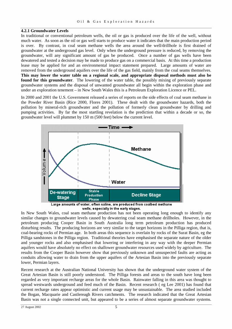
4.2.1 Groundwater Levels In traditional or conventional petroleum wells, the oil or gas is produced over the life of the well, without much water. As soon as the oil or gas well starts to produce water it indicates that the main production period is over. By contrast, in coal seam methane wells the area around the well/drillhole is first drained of groundwater at the underground gas level. Only when the underground pressure is reduced, by removing the groundwater, will any significant amount of gas be produced. Once a number of gas wells have been dewatered and tested a decision may be made to produce gas on a commercial basis. At this time a production lease may be applied for and an environmental impact statement prepared. Large amounts of water are removed from the underground aquifers over the life of the gas field, mainly from the coal seams themselves. This may lower the water table on a regional scale, and appropriate disposal methods must also be found for this groundwater. The lowering of the water table, the possibly mixing of previously separate groundwater systems and the disposal of unwanted groundwater all begin within the exploration phase and under an exploration tenement – in New South Wales this is a Petroleum Exploration Licence or PEL.
In 2000 and 2001 the U.S. Government released a series of reports on the side effects of coal seam methane in the Powder River Basin (Rice 2000, Flores 2001). These dealt with the groundwater hazards, both the pollution by mineral-rich groundwater and the pollution of formerly clean groundwater by drilling and pumping activities. By far the most startling revelation is the prediction that within a decade or so, the groundwater level will plummet by 150 m (500 feet) below the current level.
In New South Wales, coal seam methane production has not been operating long enough to identify any similar changes to groundwater levels caused by dewatering coal seam methane drillholes. However, in the petroleum producing Cooper Basin in South Australia long term petroleum production has produced disturbing results. The producing horizons are very similar to the target horizons in the Pilliga region, that is, coal-bearing rocks of Permian age. In both areas this sequence is overlain by rocks of the Surat Basin, eg the Pilliga sandstones in the Pilliga region. Traditional theories have emphasised the separate nature of the older and younger rocks and also emphasised that lowering or interfering in any way with the deeper Permian aquifers would have absolutely no effect on shallower groundwater resources used widely by agriculture. The results from the Cooper Basin however show that previously unknown and unsuspected faults are acting as conduits allowing water to drain from the upper aquifers of the Artesian Basin into the previously separate lower, Permian layers.
Recent research at the Australian National University has shown that the underground water system of the Great Artesian Basin is still poorly understood. The Pilliga forests and areas to the south have long been regarded as very important recharge areas for the whole Basin. Rainwater falling in this area was thought to spread westwards underground and feed much of the Basin. Recent research ( eg Lee 2001) has found that current recharge rates appear optimistic and current usage may be unsustainable. The area studied included the Bogan, Macquarie and Castlereagh Rivers catchments. The research indicated that the Great Artesian Basin was not a single connected unit, but appeared to be a series of almost separate groundwater systems.

O i l & G a s E x p l o r a t i o n H a z a r d s
27 August 2002 6
Pollution of or lowering of the water table under this model would have a very severe effect over the surrounding district, rather than a smaller effect over the total basin.
4.2.2 Surface Pollution - Produced Water ‘Produced water’ includes all water produced by drilling, including ground water (or ‘formation water’) and water introduced by the drilling or testing operations The main type of pollution hazard associated with water produced during the extraction of coal seam methane is the high concentration of dissolved salts. Other possible pollutants include crude oil released by coal-bearing strata into the water in some coalfields. Experience in the USA has shown that it may take from two weeks to six months to completely dewater the area around one drill hole or well, and require the disposal of up to 350m3/day of water. In contrast to traditional natural gas wells, water production tends to decline through the gas production period. However, water extraction usually does continue throughout the lifetime of the well and it is often necessary to dispose of significant quantities of co-produced water.
More water is produced in coal seam methane extraction than in traditional natural gas extraction. For example, coal seam methane contributes <2% of the total gas production in the USA but almost 13% of the water produced (10 million cubic metres per annum for coal seam methane wells). On average, for wells in the USA conventional (ie not associated with coal seam methane resources) natural gas yields about 0.13 cubic cm of water per cubic metre of gas, whereas coal seam methane produces about 1.74 cubic cm. This is about 13½ times as much water per unit volume of gas produced.
The concentration of total dissolved solids (TDS) ranges in coal seam methane produced waters from 500 mg/l to 27,000 mg/l in the eastern USA and 200-4,000 mg/l in the western USA.
SALINITY AND SODIC SOILS Salinity is a measure of the total concentration of all water-soluble salts in water and soil. Two important properties of salt affected soils are: (1) the quantity of soluble salts in the soil, and (2) the exchangeable-sodium percentage. On the basis of these values, the soil can be classed as:-
saline, which denotes excess soluble salts; sodic, a term indicating that excess exchangeable sodium is found in the soil, and, saline-sodic, which recognizes the presence of both conditions.
In Australia, sodic soils cover about 30% of agricultural land, or five times greater than the area of saline soil.
Sodium carbonate is a very common salt in groundwater in the eastern part of the Great Artesian Basin, and in rocks below the basin. Sodium carbonate has been used traditionally as washing soda, because it has the effect of loosening ‘dirt’ (by dispersing the clay particles) and removing or partially dissolving organic stains. When sodium carbonate builds up in soil, the same reactions take place. The clay particles dis-aggregate
Representative compositions of produced water associated with coal seam methane
Major components mg/l Trace elements & hydrocarbons µ�g/l Total dissolved solids 4,000 silver (Ag) 1.1 aluminium (Al) 40 chloride (Cl-) 2,000 barium (Ba) 2,780 sulphate (SO4 2-) 12.9 cadmium (Cd) 5 bicarbonate (HCO3
-) 597 chromium (Cr) 3 carbonate (CO3 2-) 0.008 copper (Cu) 5.6 fluoride (F-) 2.6 mercury (Hg) 0.13 nitrate (NO3
-) 3.0 lithium (Li) 92 iron (Fe) 10 manganese (Mn) 250 calcium (Ca) 89 nickel (Ni) 29 sodium (Na) 1,906 lead (Pb) 55 potassium (K) 7.5 antimony (Sb) 30
selenium (Se) 25 pH 7.8 strontium (Sr) 4,000
vanadium (V) 5 zinc (Zn) 109 total hydrocarbons 210

O i l & G a s E x p l o r a t i o n H a z a r d s
27 August 2002 7
forming either a slurry, when wet, or a hard impervious layer, when dry. Organic material is dissolved out of the soil helping to destroy the texture, making it a barren material for soil organisms. This dissolved vegetable remains in a soluble state and will re-dissolve whenever ther is enough moisture. The brief description below presents some aspects of the chemistry involved.
If carbonate is an important fraction of the accumulating salts, calcium and magnesium will be in low concentration because of their tendency to precipitate as very slightly soluble carbonates. Calcium carbonate solubility decreases with rising temperature, so precipitate build-up during summer may accelerate due to increased temperatures as well as increased evaporation. Similar to sodium increase, carbonate build-up in the soil can reduce hydraulic conductivity and decrease the downward movement of water.
Excess exchangeable sodium is harmful to plants principally because it produces undesirable physical and chemical conditions in soils. One result is the dispersion of clay, which lowers the permeability of the soil to air and water. Dispersion also results in the formation of dense, impenetrable surface crusts that greatly hinder the emergence of seedlings. Sodic soils low in neutral salts often have a pH as high as 10. The high pH of sodic soils causes soil organic matter to dissolve. If the dissolved organic matter is carried upward by the capillary rise of water, it may be deposited as a dark incrustation on the surface of the soil. When present, a dark-coloured surface film is usually indicative of a sodic-soil condition.
Salts such as calcium carbonate and calcium sulphate flocculate colloidal matter in soils. Saline-sodic soils therefore tend to appear deceptively in a better physical state than do non-saline-sodic soils. Under some circumstances, the pH of saline-sodic soils is no higher than 8.5 However, although neutral salts improve the physical state and lower the pH of sodic soils, they do not improve overall conditions for plant growth. If the salts are removed, as by leaching or precipitation, the characteristics associated with dispersed clay and a high pH quickly reappear.
BOHENA The Bohena No.2 drillsite in the northern Pilliga forest is an extreme case of sodic soil pollution as the direct result of careless exploration practices. Similar effects can also be seen at two other sites in the Bohena area. The Bohena gas prospect, sometimes known as the “Narrabri Gas Field”, is near the junction of the Newell Highway and the Pilliga Forest Way, approximately 30 kilometres south west of Narrabri in the Pilliga East State Forest
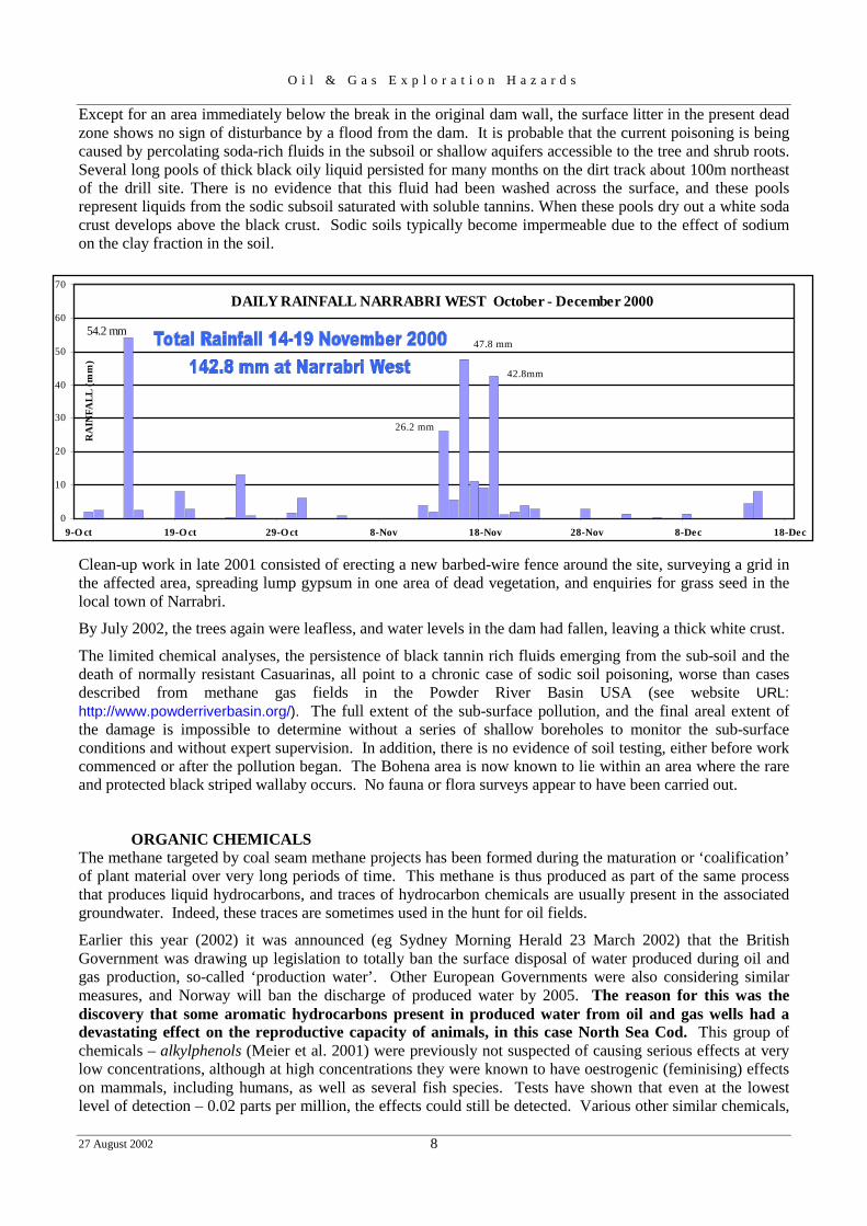
The Bohena No.2 well (total depth 908 m) was completed in June 1998, and Bohena 2D, on the same one hectare site, was completed in September 1998. A barbed wire fence now encloses an area of about 80 metres by 90 metres containing the boreholes Bohena 2 and 2D, and the holding dam. This dam was built to contain the ground water pumped from underground, mainly from coal seams. It originally had a spillway in the northeastern corner to drain off excess soda-rich water in to the surrounding forest which is in the catchment of Bohena Creek, a tributary of the Namoi River. Testing of gas-bearing sandstones and coals intersected by these wells continued into 2000. Portions of the settling dam wall collapsed and a very saline/sodic fluid poured in to the forest at the southern edge of the site. This collapse probably followed a heavy storm in November 2000.. The debris from the dam wall break of late 2000 can be clearly seen south of the fence line. Pale coloured silt covers an area about 30m wide and 40m fanning out southwards from the repaired and enlarged dam wall.
The collapse of the retaining dam wall was a separate event from the extensive leakage from the dam (excavated in sandy soil) which resulted in the spread of sodic/saline liquid through the subsoil and shallow aquifers. At least as early as February 2001, trees adjacent to the site began to show signs of dieback, with dead and discoloured leaves. Slight depressions in the forest floor were filled with a black treacle-like liquid. Water in the retaining dam and the black sludge were sampled by the NSW Environmental Protection Agency in April 2001. Limited analyses showed the black sludge contained high levels of tannin. The sodium level in dam water samples was 3,700 mg/litre, or one third to one quarter that of sea water.
The repaired dam wall remained intact but the area of dying vegetation continued to expand at this site. In addition, trees began to die at two other sites (No.4 and No.3) up to a kilometre away where the saline water from No.2 site had been diverted to through a polythene pipe. By November 2001 the pollution front at No.2site could be traced eastwards over distance of 250m and a maximum width of 100 metres. South east of the drill site most trees appeared lifeless, although a small amount of re-sprouting was visible for a short time on some of the larger trees. A lobe of dead vegetation extends northeastwards across a track for 100 metres.
O i l & G a s E x p l o r a t i o n H a z a r d s
27 August 2002 8
Except for an area immediately below the break in the original dam wall, the surface litter in the present dead zone shows no sign of disturbance by a flood from the dam. It is probable that the current poisoning is being caused by percolating soda-rich fluids in the subsoil or shallow aquifers accessible to the tree and shrub roots. Several long pools of thick black oily liquid persisted for many months on the dirt track about 100m northeast of the drill site. There is no evidence that this fluid had been washed across the surface, and these pools represent liquids from the sodic subsoil saturated with soluble tannins. When these pools dry out a white soda crust develops above the black crust. Sodic soils typically become impermeable due to the effect of sodium on the clay fraction in the soil.
Clean-up work in late 2001 consisted of erecting a new barbed-wire fence around the site, surveying a grid in the affected area, spreading lump gypsum in one area of dead vegetation, and enquiries for grass seed in the local town of Narrabri.
By July 2002, the trees again were leafless, and water levels in the dam had fallen, leaving a thick white crust.
The limited chemical analyses, the persistence of black tannin rich fluids emerging from the sub-soil and the death of normally resistant Casuarinas, all point to a chronic case of sodic soil poisoning, worse than cases described from methane gas fields in the Powder River Basin USA (see website URL: http://www.powderriverbasin.org/). The full extent of the sub-surface pollution, and the final areal extent of the damage is impossible to determine without a series of shallow boreholes to monitor the sub-surface conditions and without expert supervision. In addition, there is no evidence of soil testing, either before work commenced or after the pollution began. The Bohena area is now known to lie within an area where the rare and protected black striped wallaby occurs. No fauna or flora surveys appear to have been carried out.
ORGANIC CHEMICALS The methane targeted by coal seam methane projects has been formed during the maturation or ‘coalification’ of plant material over very long periods of time. This methane is thus produced as part of the same process that produces liquid hydrocarbons, and traces of hydrocarbon chemicals are usually present in the associated groundwater. Indeed, these traces are sometimes used in the hunt for oil fields.
Earlier this year (2002) it was announced (eg Sydney Morning Herald 23 March 2002) that the British Government was drawing up legislation to totally ban the surface disposal of water produced during oil and gas production, so-called ‘production water’. Other European Governments were also considering similar measures, and Norway will ban the discharge of produced water by 2005. The reason for this was the discovery that some aromatic hydrocarbons present in produced water from oil and gas wells had a devastating effect on the reproductive capacity of animals, in this case North Sea Cod. This group of chemicals – alkylphenols (Meier et al. 2001) were previously not suspected of causing serious effects at very low concentrations, although at high concentrations they were known to have oestrogenic (feminising) effects on mammals, including humans, as well as several fish species. Tests have shown that even at the lowest level of detection – 0.02 parts per million, the effects could still be detected. Various other similar chemicals,
DAILY RAINFALL NARRABRI WEST October - December 2000
54.2 mm
42.8mm
47.8 mm
26.2 mm
0
10
20
30
40
50
60
70
9-O ct 19-O ct 29-O ct 8-Nov 18-Nov 28-Nov 8-Dec 18-Dec
RA
INFA
LL (m
m)
O i l & G a s E x p l o r a t i o n H a z a r d s
27 August 2002 10
6. SELECTED REFERENCES Clarke L. B., 1996. Environmental aspects of coal seam methane extraction, with emphasis on water
treatment and disposal; Transactions Institute of Mining & Metallurgy: A105-A113: May – August 1996
Flores R. M. 2001. Impacts and Issues of COAL SEAM METHANE Development. IN Flores R. M. & six others. A Field Conference on Impacts of Coal seam Methane Development in the Powder River Basin, Wyoming. US Geological Survey Open File Report 01-126; US Department of the Interior. (downloaded from http://greenwood.cr.usgs.gov/energy/OF01-126)
Lee, J. Water usage needs urgent review. ANU Reporter 32 No.3 16 March 2001 from; [http//www.anu.edu.au/reporter]
Meier, S. T.E.Anderson, L. Hasselberg, O. S. Kjesbu, J. Klungsøyr and A. Svardal, 2001. Hormonal effects of C4 – C7 alkylphenols on cod (Gadus morhua). From Institute of Marine Research, Bergen, Norway, website.
Rice, C. A., M. S. Ellis, and J. H. Bullock Jr., 2000. Water co-produced with coal seam methane in the Powder River Basin, Wyoming: preliminary compositional data. US Geological Survey Open File Report 00-372; US Department of the Interior.
Swartz E., 2001. Testimony Submitted on 4 September 2001 to the Committee on Resources Subcommittee on Energy & Mineral Resources, Washington DC (downloaded from http://www.powderriverbasin.org)
USGS 1997. Coal seam Methane- an Untapped Energy Resource and an Environmental Concern. US Geological Survey Fact Sheet FS-019-97; U.S. Department of the Interior. [downloaded from http://energy.usgs.government/factsheets/Coal seam/coalmeth.html]
USGS October 2000. Coal-Bed Methane: Potential and Concerns. US Geological Survey Fact Sheet FS-123-00; U.S. Department of the Interior.
Web sites for data on sodic soils:
Powder River Basin Resource Council 23 N. Scott Sheridan, Wyoming 82801 E-mail: [email protected] Web Site URL: http://www.powderriverbasin.org/
Dr P.Rengasamy - National audits of soil sodicity..at:-National Land & Water resources Audit: http://www.nlwra.gov.au/minimal/30_themes_and_projects/50_scoping_projects/04_methods_papers/26_Rengasamy/So
dicity.html Seelig, B. D. & J. L. Richardson. Salinity and Sodicity in North Dakota SOILS EXTENSION BULLETIN @ NDSU EXTENSION SERVICE North Dakota State University, Fargo, ND 58105 http://hermes.ecn.purdue.edu:8001/water_quality/formatted/eb-571.nd.ascii
Salinity @ http://www.waite.adelaide.edu.au/school/Soil/salinity.html Frost, F & G. Orr, 1990. Identifying gypsum-responsive soils. Department of Agriculture - Western Australia Farmnote 57/1990 download from: http://www.agric.wa.gov.au/agency/pubns/farmnote/1990/f05790.htm
Sodicity – a dirty word in Australia download from Australian Academy of Science: http://www.science.org.au/nova/035/035key.htm ; This contains a good list of publications and web pages as well as activities and field tests.