infrastructure services report to aberdeenshire council 22
TRANSCRIPT

Infrastructure Services
REPORT TO ABERDEENSHIRE COUNCIL – 22 NOVEMBER 2018 Reference No: APP/2018/1891 Planning Permission in Principle - National application for construction of onshore electrical transmission cables, comprising an onshore transition jointing pit, underground cables within a 6km (approximately) long cable corridor also including temporary construction compounds, access tracks, laydown areas and other associated works, landing at shoreline within the vicinity of Redhythe Point, Sandend, travelling south and exiting Aberdeenshire at Cotton Hill, Fordyce. 1. Purpose of Report 1.1 This report refers to an application for a National Development. In
accordance with Aberdeenshire Council’s agreed Scheme of Delegation, this type of application requires to be determined by Full Council. Due to the application site being located within the Banff and Buchan Area, the application was referred to Banff and Buchan Area Committee for comment, before being determined by Full Council.
1.2 The Head of Finance and Monitoring Officer within Business Services have been consulted in the preparation of this report, had no comments to make and are satisfied that the report complies with the Scheme of Governance and relevant legislation.
2. Background and Proposals 2.1 The proposal involves the landfall and laying of an underground electrical
transmission cable, in association with a proposed offshore wind farm known as “Moray West” in northern Aberdeenshire. The proposal involves the laying of the cable within a wide application corridor, stretching from Redhythe Point on the north coast just east of Sandend, which would then travel south/south westwards towards the settlement of Fordyce and then Cotton Hill beyond. The proposed corridor would then split temporarily, offering two potential routes, before re-joining within the Moray Council area. The proposed corridor would continue to travel through the Moray Council area to a proposed substation site to the south of Keith, in the vicinity of the existing Blackhillock substation site.
2.2 Moray West is split into 3 component parts, namely an “offshore” application
plus two “onshore” applications. The offshore process involves a consenting process through Marine Scotland Licensing Operations Team (MS-LOT) for the establishment of the offshore infrastructure associated with the wind farm. The offshore wind farm would consist of up to 85 wind turbine generators (WTG) located in the Moray Firth, adjacent to the Beatrice and Moray East offshore wind projects, and, at the time of writing, this is under consideration by MS-LOT. The offshore application would include the export cabling and
Item: 4Page: 15

infrastructure which would ultimately connect into the proposed onshore landfall point covered within this current application. From the onshore landfall point, as described above, the proposal will involve further planning applications in north Aberdeenshire (cabling) and Moray (cabling and substation). While the onshore components are effectively the same development, the crossing of local authority boundaries means that they will have independent determination processes.
2.3 There is, therefore, some crossover and interrelationship between the
component parts. However, with regard to this specific planning application within Aberdeenshire, the landfall point and approximately 6km of underground cabling ending at the Aberdeenshire/Moray boundary near Cotton Hill will be the focus of this report, and the element of the scheme requiring determination by Aberdeenshire Council.
2.4 This proposal is categorised as a National Development, as defined in The
Town and Country Planning (Hierarchy of Developments) (Scotland) Regulations 2009, and as identified in the National Planning Framework 3 (NPF3). NPF3 advises that the erection of any new substations directly linked to cabling of 132 kilovolts or higher forms part of the high voltage electricity transmission network upgrade and is, therefore, a National Development. In this case, the entire project, and, by definition, each component part, is classed as a National Development.
2.5 Currently, the proposal is at Planning Permission in Principle (PPP) stage, full
and detailed proposals would follow on after the grant of any planning permission in principle and would define an exact cable route, exact construction methods and importantly outline and confirm the detailed mitigation proposals for the scheme. This method of determination is familiar to Aberdeenshire Council, being the process by which the separate, but relatable, “Moray East” scheme progressed.
2.6 The project is also subject to the Environmental Impact Assessment (EIA)
Regulations and the application has been submitted with an Environmental Impact Assessment Report (EIAR), which outlines the environmental designations and likely, or potential, impacts of the project upon the environment, as well as outlining and seeking the assessment of, and agreement on, proposed mitigation for any impacts. As the application is for PPP only, the proposal has been assessed under the “Rochdale Envelope” technique where the worst case scenario has been used for the assessment. This approach recognises the need for the details of a project to grow over a number of years within clearly defined parameters. The EIAR takes account of worst case scenarios so that the potential effects can be well understood and adequate mitigation can be put in place. The PPP approach also assists in the project conforming to Schedule 4 of the EIA Regulations whereby alternatives to the development require to be investigated. The Multi-Stage Consent approach means that throughout this process there are multiple areas of consideration and alternatives can be considered for all elements of the scheme.
Item: 4Page: 16

2.7 The offshore transmission cables would come ashore at the landfall point (yet to be completely defined) and connect into the proposed onshore cabling via a “Transition Joint Bay” located above the Mean High Water Springs (MHWS). The landfall corridor is characterised by cliffs and rocky outcrops which stretch northwards from the beach. The onshore cabling would connect to the proposed substation in Moray via two cable circuits, each with a tri-fold cable arrangement and possibly fibre optic cabling buried approximately 1m below ground. The proposed cable corridor would reach 2.2km at its widest, with 270m representing the narrowest point of the proposed corridor. However, the finalised corridors for the cable circuits would amount to 30m in width.
2.8 Given the scale and nature of development, pre-application consultation
(PAC) with the community was conducted by the developer. Throughout this consultation, a number of concerns were raised by members of the community relating to potential adverse impacts upon Sandend Beach, in terms of environmental damage and adverse effects on sports or recreation. The developer had confirmed at the point of consultation that Sandend was just one of a number of locations within a wide corridor where landfall could take place. However, based on the feedback received, the proposed corridor has since been amended and Sandend Beach completely excluded from the proposed application boundary. This confirms that Sandend Beach will not be used and is no longer an option for consideration under this application.
2.9 The following documents are attached as appendices:
• Appendix 1: Location Plan
• Appendix 2: Copy of Banff and Buchan Area Committee report of 2 October, 2018.
• Appendix 3: Extract of Minute of Banff and Buchan Area Committee of 2 October, 2018.
3. Representations (Summary) 3.1 A total of 3 valid representations (objection) have been received, as defined in
the Scheme of Delegation. All issues raised have been considered. The letters raise the following material issues:
• Impact upon local environmental heritage assets
• Impact upon local cultural heritage assets
• Impact upon recreation and tourism
• Impact upon wildlife
• Impacts from construction noise
• Traffic disruption
• Flood risk 4. Principal Planning Issues (Summary) 4.1 The main planning considerations with this application relate to the principle of
development, and the potential environmental impacts, including impacts on
Item: 4Page: 17

hydrology/geology, ecology, landscape, historic environment, traffic and transport, noise and vibration, air quality, socio-economics and land use.
4.2 As outlined above, the proposal is at PPP stage only and, as such, covers a
wide corridor, meaning that detailed aspects such as the landfall point and exact cable route are still to be defined or decided. This is an acceptable approach for such a large project and with previous, similar style projects, this method, a “multi stage” process, has helped to select optimal points for installation following further surveys and analysis, as outlined and set out within the preceding PPP and associated mitigation. Members may recall previous projects including “Moray East” where a similar over-arching PPP application was approved in the first instance, before details including the exact landfall location, cable route and specific mitigation were all afforded high levels of scrutiny at subsequent Matters Specified in Conditions (MSC) phases. In broad terms, a similar structure and approach is being taken with this application.
4.3 An expanded discussion is contained within the Area Committee report which
is attached as Appendix 2. Extracts of Minutes of the Area Committee meeting are attached at Appendix 3. The main issues are summarised below.
4.4 This application is supported by an EIAR which outlines and assesses the
likelihood of the proposed development adversely impacting the environment, as well as outlining what mitigation is proposed to manage any potential impacts. The EIAR concludes that the majority of potential impacts would be derived from the construction phase of the project, for which embedded mitigation in terms of good practice measures and steps within the design process should be able to avoid any significant impacts upon the environment. A total of 5 potential significant impacts are identified within the EIAR, but these can be addressed through specific, tailored mitigation which, in turn, would ensure that the net result would be that the project would not give rise to any significant environmental impacts.
4.5 Through assessing the application against National, Strategic and Local
Planning Policy, the principle of development can be agreed. The project is classed as a National Development, being electrical transmission infrastructure in excess of 132kV and subsequently being seen as imperative to the upgrading of the national electricity transmission network. This classification establishes the need for the project to progress. The Strategic Development Plan offers broad support for renewable energy development. This is a similar case with the Local Development Plan, which again offers broad support subject to impacts upon specific receptors and policy being mitigated, if required. The EIAR outlines that mitigation can be implemented to ensure that no adverse impacts upon the environment result.
4.6 Assessing the proposal, the principle of development is considered to be
acceptable, subject to the securing of mitigation through appropriate planning conditions. These proposed conditions would allow for further analysis of the proposed project details and in turn a full assessment on specific impacts,
Item: 4Page: 18

mitigation and, if necessary, compensation with regard to sensitive receptors, including a Site of Special Scientific Interest, hydrology and hydrogeology, recreational and residential amenity, the natural and historical environments, as well as impacts upon land uses.
4.7 In assessing the conclusions of the EIAR with due cognisance of planning
policy, as well as the mitigation measures outlined, it is considered that the development will not have a significant adverse effect upon the environment. The application is therefore considered to be acceptable.
5. Area Committee Decision (Summary) 5.1 The application was referred to Banff and Buchan Area Committee, as
described above, and as per Appendices 2 and 3. Banff and Buchan Area Committee agreed to confirm support for the application in principle, subject to the undernoted additional comments, in advance of Full Council on 22 November, 2018.
• Continued community engagement sought.
• Confirmation that the SSSI: Cullen and Stake Ness Coast Site of Special Scientific Interest is protected and not damaged.
• Protection of the coastal path network.
• Liaison with local climbers and protection of climbing assets. 5.2 The Planning Service notes and agrees with the importance of the above
issues. Through the proposed schedule of planning conditions and subsequent requirement for the developer to address these, all matters can be fully analysed and assessed to ensure that resources and environmental/recreational assets are not compromised or damaged. Furthermore, the nature and structure of these conditions is considered to establish an appropriate mechanism for engagement with the community and associated recreational groups as a matter of course.
5.3 The conditions listed in the Banff and Buchan Area Committee report have
been subject to some minor amendments and rewording in order to ensure that all matters can be successfully covered and also as a result of further liaison with Moray Council, in order to ensure consistency across the wider project. A revised schedule of conditions is listed in section 10 of this report. The scope of these conditions has remained the same as previously presented, with changes limited to very minor rewording.
6. Area Implications 6.1 In the specific circumstances of this application, there is no direct connection
with the currently-specified objectives and identified actions of the Local Community Plan.
Item: 4Page: 19

7. Equalities, Staffing and Financial Implications 7.1 An Equality Impact Assessment is not required because the granting or
refusing of this application is not considered to have a detrimental impact on the protected characteristics of the applicant or any third parties.
7.2 There are no staffing and financial implications. 8. Sustainability Implications 8.1 No separate consideration of the current proposal’s degree of sustainability is
required as the concept is implicit to, and wholly integral with, the planning process, against the policies of which it has been measured.
9. Departures, Notifications and Referrals 9.1 Development Plan Departures
None. 9.2 The application is not a Departure from the Development Plan but has been
advertised in the press as a National Development and under the EIR Regulations. A total of 3 representations were received. The period for receiving representations has expired.
9.3 The application does not fall within any of the categories contained in the
Schedule of the Town and Country Planning (Notification of Applications) (Scotland) Direction 2009 and the application is not required to be notified to the Scottish Ministers prior to determination.
10. Officers’ Recommendation 10.1 GRANT Planning Permission in Principle, subject to:
(a) The following conditions:
(1) Details of the specified matters listed below shall be submitted for consideration by the Planning Authority, in accordance with the timescales and other limitations in Section 59 of the Town and Country Planning (Scotland) Act 1997 (as amended). No work along the cable route site shall begin until the written approval of the Planning Authority has been given and the development shall be carried out in accordance with that approval.
Specified matters:
(a) Full details of the final route of the cables, with proposed micro-siting limits. The proposed route shall demonstrate how impacts on the following have been avoided, or where avoidance is not possible, mitigated:
Item: 4Page: 20

• Wetlands, especially groundwater-dependent terrestrial ecosystems (GWDTEs), which are types of wetlands protected by the Water Framework Directive;
• Peatland;
• Private water supplies;
• Field drains;
• Groundwater;
• Engineering works in the water environment, including watercourse crossings;
• Flood risk;
• Listed Buildings;
• Assessment of potentially contaminated sites identified in EIAR (for the finalised cable route) including investigations carried out in accordance with BS 10175:2011+A2:2017 – “Investigation of Potentially Contaminated Sites – Code of Practice” , an appropriate remedial scheme, validation report and treatments of areas of hardstanding, clean cover or other such barriers;
• Recreational receptors, including walking or cycling routes and details of advance notice to users of any potential disruption;
• Noise and vibration disturbance;
• Coastal processes and costal profile. (b) Full details of all existing and proposed landscape features, including
trees, shrubs or hedging to be retained and proposed throughout the cable route. Replacement and additional planting shall be locally native species of local provenance appropriate to the Banff and Buchan area. Details shall be provided on the reinstatement of walls, woodland, hedges, recreation routes and water courses.
(c) A full pre-construction survey of protected mammals, within and
adjacent to the site. This shall include any otter resting places within the corridor.
(d) Full details of any temporary access tracks required along the cable
route. This shall include a detailed scheme for the reinstatement of the tracks.
(e) A Full Construction and Temporary Works Schedule, including plans
showing all construction and temporary works, including any borrow pits. The Schedule shall take into account the following issues:
• Wetlands
• Peatlands
• Private Water Supplies
• Engineering works in the water environment
• Flood risk, including that in association with existing field drains
Item: 4Page: 21

(f) A full site specific Construction Environmental Management Plan (CEMP). The CEMP shall address the following issues:
• Schedule of Mitigation formed from the “Schedule of best practice and mitigation commitments” contained in the Environmental Impact Assessment Report for those elements that are not covered by a Construction Site Licence obtained from SEPA
• Site Waste Management Plan, including the disposal of any surplus material
• Pollution Prevention measures, including those for the development once operational
• Schedule of Environmental Commitments
• Sediment management
• Environmental incidents
• Water management plan (terrestrial and freshwater)
• Wet weather management plan
• Drainage plan for SUDS
• Appropriate training in the CEMP and PPGs
• References to relevant Method Statements
(g) Full details of a programme of archaeological works in accordance with a written scheme of investigation.
(h) A Phasing Plan outlining details of the phasing of all construction works
of the cable route development. Thereafter, development shall be undertaken in accordance with this approved Phasing Plan.
(i) Full details of the proposed construction access route(s), including the
following:
• Vehicle swept paths for any abnormal load requirements;
• Phasing plan(s) for the cable works which confirms road improvement works required prior to commencement;
• Details of the construction access route to determine the locations of structures (e.g. bridges) and street furniture affected by any construction and/or abnormal load vehicle movements;
• Road improvements/strengthening (either temporary or permanent) required;
• Details confirming locations of cable road crossings and proposed works.
• Trunk road interactions including relevant consenting processes.
• Details of the access visibility splays for any temporary construction access junctions onto the public highway;
• Measures taken to safeguard public access and safety where the construction corridor crosses any public footpaths, cycle ways or bridal paths.
(j) A Full Mitigation Statement summarising all mitigation measures
proposed at the cable route site.
Item: 4Page: 22

(k) Full details on proposed measures and mitigation to protect the Cullen
to Stake Ness Coast Site of Special Scientific Interest (SSSI), to be prepared in consultation with Scottish Natural Heritage (SNH) and thereafter agreed by the Planning Authority. These will include coverage of the following matters:
• Where practicable, the preferred technique for the installation of infrastructure is assumed to be horizontal directional drilling (HDD), as long as this reduces the overall impacts on all features (biological and geological). A HDD method statement for works within the zone of influence (ZoI) of the SSSI will be drawn up in consultation with SNH;
• Should it prove necessary to use installation techniques other than HDD (e.g. open cut trenching), consultation will be undertaken with SNH throughout the detailed design process regarding the most appropriate approach, as well as to agree siting of infrastructure and temporary works areas;
• A botanical assessment (National Vegetation Classification [NVC]) will be undertaken within the ZoI along with surveys of the designated geological features and used to refine the exact construction methods and locations (both temporary and permanent) to avoid the best representative locations of the designated features. The potential to focus on areas where scrub encroachment (and / or other factors) is compromising the Favourable Conservation Status (FCS) of the SSSI will be considered along with a suite of bespoke mitigation and compensation measures if required; and
• If works are required within the intertidal areas of the SSSI, further Phase 1 / Phase 2 intertidal surveys will be undertaken to ensure there are no effects upon SSSI features or other sensitive habitats and communities.
Reason: Permission for the development has been granted in principle only and subsequent approval is required for these matters in accordance with Section 59 of the Town and Country Planning (Scotland) Act 1997 (as amended). (2) That the construction operations are limited to 07.00 - 19.00 Monday to
Friday and 07.00 - 13.00 on Saturdays only and on Public Holidays. Any night-time operations shall be subject to written details of the work times and any noise mitigation measures purposed to be installed being approved by the Planning Department prior to the works commencing. Reason: In order to protect the amenity of nearby and adjoining residents.
(3) That within a period not less than 6 months prior to the ultimate cessation of operation, or an alternative timeframe as agreed in writing
Item: 4Page: 23

by the Planning Authority, a Decommissioning Plan is to be prepared in line with best practice at the time of preparation and submitted for the written approval of the Planning Authority in consultation with SEPA.
Reason: To ensure provision is in place to facilitate a move towards a “Circular Economy” and futureproof the development against future environmental requirements or considerations in the interests of the protection of the natural environment.
(b) The following Direction:
DIRECTION UNDER SECTION 59 OF THE TOWN AND COUNTRY PLANNING (SCOTLAND) ACT 1997: That subsection (2)(a)(i) of section 59 of the Town and Country Planning (Scotland) Act 1997 (as amended) shall apply as respects the permission with the substitution for the period of 3 years referred to in that subsection of 5 years, as is considered appropriate by the Planning Authority in this instance on the basis of the scale of the development. The provisions of section 59(2) shall therefore be read as follows: That this planning permission in principle shall lapse unless a further application or applications for approval of the matters specified in all condition(s) attached to this grant of planning permission in principle across the entire site has been made before whichever is the latest of the following:
(i) The expiration of 5 years from the date of this grant of planning
permission in principle; (ii) The expiration of 6 months from the date on which an earlier
application for the requisite approval of matters specified in conditions was refused;
(iii) The expiration of 6 months from the date on which an appeal against such refusal was dismissed.
Pursuant to Section 59 of the Town and Country Planning (Scotland) Act 1997, as amended by the Planning etc. (Scotland) Act 2006.
10.2 Reason for Decision
The proposal and mitigation measures set out and contained therein are considered to be acceptable in terms of the relevant Policies contained within the Aberdeenshire Local Development Pan 2017. The proposal is consistent with the Development Plan’s aims of reducing carbon emissions and adapting to climate change. It also contributes to the Scottish Government’s National Planning Framework’s aim to move Scotland towards creating a low carbon place.
Stephen Archer Director of Infrastructure Services Author of Report: Stuart Murison 4/10/2018
Item: 4Page: 24
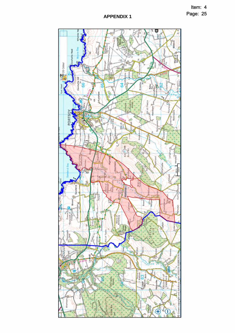
APPENDIX 1
Item: 4Page: 25

Infrastructure Services
Banff and Buchan Area Committee Report – 2 October 2018 Reference No: APP/2018/1891 Planning Permission in Principle - National for Construction of Onshore electrical transmission cables, comprising an onshore transition jointing pit, underground cables within a 6km (approximately) long cable corridor also including temporary construction compounds, access tracks, laydown areas and other associated works, Landing At Shoreline Within The Vicinity Of Redhythe Point Sandend Travelling South And Exiting Aberdeenshire At Cotton Hill Fordyce. Applicant: Mr James Grant, Moray Offshore Windfarm (West) Ltd, 5th Floor,
144 Morrison Street, Edinburgh, EH3 8EX. Agent: Mr James Grant, Moray Offshore Windfarm (West) Ltd, 5th Floor,
144 Morrison Street, Edinburgh, EH3 8EX. Grid Ref: E: 350122 N:856392 Ward No. and Name: W01: Banff and District Application Type: Planning Permission in Principle - National Representations 3 Consultations 17 Relevant Proposals Map
Designations: Countryside Main Recommendation Provide Comments to Full Council (GRANT)
APPENDIX 2 Item: 4Page: 26

1. Reason for Report 1.1 The Committee is able to consider this item in terms of Section B.9.1 of Part 2A
List of Committee Powers and Section C.1.1 of Part 2C Planning Delegations of the Scheme of Governance as the application is for National Development which will be determined by Full Council following consultation with the relevant Area Committee.
1.2 The Head of Finance and Monitoring Officer within Business Services have
been consulted in the preparation of this report and had no comments to make and are satisfied that the report complies with the Scheme of Governance and relevant legislation.
1.3 The application will be reported to Full Council on 22 November 2018 for a
decision. This report outlines the recommendation from the Planning Service and seeks views on the proposal from the Banff and Buchan Area Committee.
1.4 A Pre-Determination Hearing (PDH) was held in Portsoy School on Monday 24
September 2018 following a Site Visit. A report was produced for the Hearing which described the policy background, representations, and the main issues raised thus far. A note of the PDH is attached as Appendix 1 to this report.
2. Background and Proposal 2.1 The proposal involves the landfall and laying of an underground cable, in
association with a proposed offshore Wind Farm known as “Moray West” in northern Aberdeenshire. The proposal aims to establish the laying of said underground cable within a wide application corridor stretching from Redhythe Point on the north coast, just east of Sandend, which would then travel south/south westwards towards the settlement of Fordyce and then Cotton Hill beyond where the proposed corridor would split temporarily offering two potential routes, before re-joining within the Moray Council area from where the proposed cable route would continue to travel through the Moray Council area to a proposed substation site to the south of Keith, in the vicinity of the existing Blackhillock substation site. Moray West would consist of up to 85 wind turbine generators (WTG) located in the Moray Firth, adjacent to the Beatrice and Moray East offshore wind projects.
2.2 The wider proposal is split into 3 component parts, namely an “offshore”
application plus two “onshore” applications. The offshore process involves a consenting process through Marine Scotland Licensing Operations Team (MS-LOT) for the establishment of the offshore infrastructure associated with the wind farm. The offshore wind farm would consist of up to 85 wind turbine generators (WTG) located in the Moray Firth, adjacent to the Beatrice and Moray East offshore wind projects, at the time of writing this is under consideration by MS-LOT. This application would include the export cabling and infrastructure which would ultimately connect into the proposed landfall point covered within this current application. From the onshore landfall point, as described above, the proposal involves two further component parts in onshore planning applications within Aberdeenshire and then Moray Council areas.
Item: 4Page: 27

While the onshore components are effectively the same development, the crossing of Local Authority boundaries means that they will have independent determination processes.
2.3 There is therefore some crossover and interrelationship between the
component parts, however with regard to this specific planning application within Aberdeenshire – the landfall point and approximately 6km of underground cabling ending at the Aberdeenshire/Moray boundary near Cotton Hill will be the focus of this report and the element of the scheme requiring determination by Aberdeenshire Council.
2.4 This proposal is categorised as a National Development, as defined in The
Town and Country Planning (Hierarchy of Developments) (Scotland) Regulations 2009, and as identified in the National Planning Framework 3 (NPF3). NPF3 advises that the erection of any new substations directly linked to cabling of 132 kilovolts or higher forms part of the high voltage electricity transmission network upgrade and is therefore a National Development. In this case, the entire project and by definition each component part is classed as a National Development.
2.5 Currently, the proposal is at Planning Permission in Principle (PPP) stage, full
and detailed proposals would follow on after the grant of any planning permission and would define an exact cable route, exact construction methods and importantly outline and confirm the detailed mitigation proposals for the scheme. This method of determination is familiar to Aberdeenshire Council, being the process by which the separate but relatable “Moray East” scheme progressed.
2.6 The project is also subject to the Environmental Impact Assessment (EIA)
regulations and the application has been submitted with an Environmental Impact Assessment Report (EIAR) which outlines the environmental designations and likely or potential impacts of the project upon the environment as well as outlining and seeking the assessment of, and agreement on proposed mitigation for any impacts. As the application is for PPP only, the proposal has been assessed under the “Rochdale Envelope” technique where the worst case scenario has been used for the assessment. This approach recognises the need for the details of a project to grow over a number of years within clearly defined parameters. The EIA takes account of worst case scenarios so that the potential effects can be well understood and adequate mitigation can be put in place. The PPP approach also assists in the project conforming to Schedule 4 of the EIA Regulations whereby alternatives to the development require to be investigated, the Multi Stage Consent approach means that throughout this process there are multiple areas of consideration and alternatives can be considered for all elements of the scheme.
2.7 As part of this application, the submission does indicate that the offshore
transmission cables would come ashore at the landfall point (yet to be completely defined) and connect into the proposed onshore cabling via a “Transition Joint Bay” located above the Mean High Water Springs (MHWS). The landfall point has not yet been defined, but the site is characterised by cliffs
Item: 4Page: 28

and rocky outcrops which stretch northwards from the beach. The onshore cabling would connect to the proposed substation in Moray via two cable circuits, each with a tri-fold cable arrangement and possibly fibre optic cabling buried approximately 1m below ground. The proposed cable corridor would reach 2.2km at its widest, with 270m representing the narrowest point of the proposed corridor, however the finalised corridors for the cable circuits would amount to 30m in width.
2.8 Given the scale and nature of development, pre application consultation with
the community (PAC) was conducted by the developer. Throughout this consultation, a number of concerns were raised by members of the community relating to potential adverse impacts upon Sandend Beach in terms of environmental damage and adverse effects on sports or recreation. The developer had confirmed at the point of consultation that Sandend was just one of a number of locations within a wide corridor where landfall could take place. However based on the feedback received, the proposed corridor has since been amended and Sandend Beach completely excluded from the proposed application boundary, this in effect confirms that Sandend Beach won’t be used and is no longer an option for consideration under this application.
3. Representations 3.1 A total of 3 valid representations (objection) have been received as defined in
the Scheme of Delegation. All issues raised have been considered. The letters raise the following material issues:
Impact upon local environmental heritage assets
Impact upon local cultural heritage assets
Impact upon recreation and tourism
Impact upon wildlife
Impacts from construction noise
Traffic disruption
Flood risk 4. Consultations 4.1 Infrastructure Services (Archaeology) advised that there were no objections
to the proposal, subject to a programme of archaeological works being agreed as part of any subsequent Matters Specified in Conditions phase.
4.2 Infrastructure Services (Contaminated Land) confirmed that there were no
objections to the proposal and the conclusions of the EIAR were considered to be appropriate. Additional surveys, investigations and confirmation of mitigation will require to be agreed at any future Matters Specified in Conditions phase.
4.3 Infrastructure Services (Economic Development) advised that they had no
comments to make on the application. 4.4 Infrastructure Services (Environment Team – Natural Heritage) advised
that there were no objections to the application or the principle of development,
Item: 4Page: 29

subject to details of the final cable route, mitigation and further surveys being provided through any subsequent Matters Specified in Conditions phase. Specific details of any temporary re-routing and reinstatement of the core path network were also requested.
4.5 Infrastructure Services (Environmental Health) advised that there were no
objections to the application subject to the implementation of appropriate and stated mitigation as well as restrictions on construction working hours in the interests of amenity.
4.6 Infrastructure Services (Flood Risk and Coast Protection) advised that
there were no objections to the application, the coverage in the EIAR was considered to be appropriate and conditions relating to full details of the proposed cable route, watercourse crossings and a demonstration of flood risk be included within any grant of planning permission.
4.7 Infrastructure Services (Roads Development) advised that there were no
objections to the application. This Service did request that details of any temporary accesses or construction accesses and their interaction with the public road network be provided at any future Matters Specified in Conditions phase. No abnormal loads are anticipated.
4.8 Infrastructure Services (Transportation) advised that they had no comments
to make on the application. 4.9 Fordyce, Sandend and District Community Council outlined some concerns
with the proposal, specifically raising concerns with the methodology of landfall installation and seeking the protection of designated and local geological features alongside associated impacts upon other receptors along the shoreline. Similarly, concerns were specifically raised with regard to access arrangements and road safety. Pre-emptive objections were made with regard to both of the above dependant on any final design or methodology – these objections are therefore slightly premature at this stage given they specifically object to detailed design factors, as opposed to the principle of development. The overarching issues are however appropriate for consideration at this stage and they raise legitimate concerns with regard to shaping and directing any potential mitigation. Other issues raised included coverage of landscape protection, protection of historical assets, flood risk, construction noise/disruption and recreation.
4.10 Health and Safety Executive advised that they had no objections or concerns
with the proposal. 4.11 Historic Environment Scotland advised that there were no objections to the
application and that they were satisfied that relevant historic assets would not be adversely effected as a result of the development.
4.12 Moray Council confirmed that there were no objections to the Aberdeenshire
section of the application.
Item: 4Page: 30

4.13 Portsoy and District Community Council offered comments seeking the protection of Sandend Beach, the protection and risk management of any interactions the works may have with the local climbing community, sought the restoration of the coastal path if disrupted and commented on a wider desire for community benefits as a result of the proposal.
4.14 SNH advised that subject to specific mitigation being implemented and secured
via condition with regard to the protection of the designated Site of Special Scientific Interest (SSSI) that there were no objections to the application.
4.15 SEPA confirmed that there were no objections to the application subject to
appropriate conditions securing mitigation. 4.16 Scottish Water confirmed that there were no objections to the application,
outlined previous discussions and potential impacts and also stated that further input would be made at any future detailed design phase.
4.17 Transport Scotland advised that there were no objections to the application
subject to conditions requiring any proposed interactions with the trunk road network to be detailed and agreed at any subsequent Matters Specified in Conditions phase. No abnormal loads are anticipated.
5. Planning Policies 5.1 The National Planning Framework for Scotland 3 (NPF3) 5.1.1 The NPF, published in June 2014, sets out a long term strategy for Scotland’s
spatial development and supports the country’s transition to a low carbon economy. It confirms that development which consists of new electricity transmission cabling in excess of 132 kilovolts is designated a national development.
5.2 Scottish Planning Policy (SPP) 5.2.1 SPP was published in June 2014, superseding the previous SPP published in
2010. It outlines that while the Town and County Planning (Scotland) Act 1997 requires that decisions should be made in accordance with the Development Plan, unless material considerations indicate otherwise, it confirms that the content of the SPP is a material consideration that carries significant weight. One of the four planning aims relates to reducing carbon emissions and adapting to climate change by achieving 30% of overall energy demand from renewable sources by 2020, rising to 100% by 2050.
5.3 Aberdeen City and Shire Strategic Development Plan 2014 5.3.1 The shift to a low carbon economy has also been identified in the Aberdeen
City and Shire Strategic Development Plan. One of the key objectives is to put infrastructure in place in order to achieve Scotland’s low carbon targets.
Item: 4Page: 31

5.4 Aberdeenshire Local Development Plan 2017 Policy C2 – Renewable Energy Policy C4 – Flooding
Policy R1 – Special Rural Areas Policy P4 – Hazardous and Potentially Polluting Developments Policy E1 – Natural Heritage Policy E2 – Landscape Policy HE1 – Protecting Historic Building Sites and Monuments Policy HE2 – Protecting Historic & Cultural Areas Policy PR1 – Protecting Important Resources Policy RD1 – Providing Suitable Services.
6. Discussion 6.1 Overview 6.1.1 The main planning considerations with this application relate firstly to
establishing the principle of development, before potential environmental impacts including impacts on hydrology/geology, ecology, landscape, historic environment, socio economics and land use are considered. As outlined above, the proposal is at PPP stage only and as such covers a wide corridor, meaning that detailed aspects such as the landfall point and exact cable route are still to be defined or decided. This is an acceptable approach to such a large project and with previous, similar style projects this method, a “multi stage” process, has helped to select optimal points for installation following further surveys and mitigation as outlined and set out within the preceding PPP and associated mitigation. Members may recall previous projects including “Moray East” where a similar over-arching PPP application was approved in the first instance, before details including the exact landfall location, cable route and specific mitigation were all afforded high levels of scrutiny at subsequent Matters Specified in Conditions (MSC) phases. In broad terms, a similar structure and approach is being taken with this application.
6.1.2 The Environmental Impact Assessment Report (EIAR) is structured in a
relatively orthodox fashion, with specific chapters for each over-arching environmental category. Within each chapter, potential receptors are identified and the likelihood of a significant adverse impact resulting from the proposed development assessed through analysing the magnitude of change and sensitivity of the receptor from an agreed baseline. Mitigation, both that embedded within the proposals in terms of good practice and design as well as additional mitigation where adverse impacts are identified and require to be addressed are also presented. The structure and methodology of the submission is considered to be acceptable.
6.1.3 The submitted EIAR covers the entirety of the onshore development, including
the stretch of underground cable proposed within the Moray Council area as well as the proposed Substation site, also in Moray. These aspects are not directly relevant to Aberdeenshire Council in the consideration of this
Item: 4Page: 32

application. This report has extracted and highlights the proposed impacts upon Aberdeenshire only.
6.2 Principle of Development 6.2.1 NPF 3, in determining the strategic economic requirements in Scotland,
promotes the aim that there should be an 80% reduction in greenhouse gas emissions by 2050 and reduction in energy use of 12% by 2020. It is considered that in order to increase the security of Scotland’s power supply, further diversification into different sources of energy will be required such as wind, wave and tidal energy. Inclusion in NPF3 effectively means that the need for the development has been established provided the proposal complies with national and local planning policies.
6.2.2 SPP advises that Strategic Development Plans should support national
priorities for the construction of strategic energy infrastructure, including generation, transmission and distribution networks. In light of this, the Aberdeen City and Shire Strategic Development Plan (SDP) provides a framework which aims to promote the economic growth and diversity of the northeast in an efficient and sustainable manner. One target is that the region’s electricity needs should be met from renewable sources by 2050. In order to facilitate this, the applicant considers that the development will be required to achieve this aim. While the SDP envisaged Peterhead to be the hub of offshore renewable energy, the fact that the cable will now join the National Grid at Blackhillock, Moray and will in turn feed through an upgraded network connecting into Aberdeenshire is considered to be within the spirit of the aims of the SDP. NPF3 acknowledges that the exact location of high voltage infrastructure is best considered at the application stage.
6.2.3 While neither the site for the substation nor the line of the underground cable
have been specifically allocated in the Local Development Plan, the aims of the plan are consistent with the Aberdeen City and Shire Strategic Development Plan where the aim is to tackle the challenges of sustainable economic development and climate change.
6.2.4 The ALDP offers broad support for renewable energy development on the
proviso that the impacts upon the surrounding environment and amenity (including visual amenity) can be mitigated. In this instance the development would form a component part of a wider renewable energy scheme, where there would be no visual impact (underground cable), while the EIAR offers a detailed assessment of the proposed environmental impacts – this is discussed later in this report.
6.2.5 With regard to establishing support for the principle of development therefore,
as above the proposal is considered to conform to National, Strategic and Local Policy and as such the overarching principle of development can therefore be agreed.
Item: 4Page: 33

6.3 Hydrology, Hydrogeology and Geology 6.3.1 Through the EIA Scoping process, it was highlighted that the Cullen and Stake
Ness Coast Site of Special Scientific Interest (SSSI) covers the proposed landfall area to the west of Sandend. This designation is down to the presence of Dalradian Hard Rock at this location and is a key geological receptor with distinctive characteristics. This matter has been highlighted within the submission and further survey work including a National Vegetation Classification (NVC) survey is proposed prior to any future detailed design stage in order to better inform the most appropriate techniques to use in order to limit or avoid any adverse impacts upon the SSSI. The EIAR as submitted outlines that a sensitive design process, choice of installation technique (including Horizontal Directional Drilling (HDD)) and best practice should reduce the significance of any potential impacts upon the receptor. Ultimately the SSSI is assessed as having a moderate level of sensitivity, with the cable installation introducing a low magnitude of change and thus leading to a non significant impact in EIA terms.
6.3.2 In addition to the SSSI, other receptors or sources of interest are identified
including watercourses such as the Scattery Burn and the Burn of Fordyce. There is also coverage of flooding sources and water supplies within the corridor. All identified receptors have been assessed in terms of sensitivity and the likely magnitude of change from anticipated potential effects.
6.3.3 Through assessing the above, the EIAR identifies that the main potential
impacts are likely to result from the construction phase, with trenching the most intrusive action. The operation of the underground cables is unlikely to give rise to any issues and with the cables proposed to remain in situ at decommissioning, again there is unlikely to be any impact. Embedded, baseline mitigation measures are proposed and given the nature of the potential impacts focus on good practice measures for the construction phase. These good practice measures include, but are not limited to, pre-construction investigations, establishing methodologies, construction programmes and pollution prevention measures.
6.3.4 To a large extent, it is concluded within the EIAR that the embedded mitigation
would successfully help to ensure that the impacts are minor or negligible and not significant on receptors including the SSSI mentioned above as well as aspects such as water supplies and flood risk receptors. The one outstanding receptor which is anticipated to experience a moderate and thus significant impact would be Ground Water Dependant Terrestrial Ecosystems (GWDTE) as a result of potential dewatering from trenches, disturbance from access tracks or risk of pollution/fuel spills. Additional mitigation is therefore proposed to help address these impacts in the form of further detailed investigation at any future detailed design phase, including an NVC survey which would in turn help to inform buffers required to reduce potential impacts. Similarly infrastructure would be positioned at sufficient distances from receptors based on the results of any further surveys. Drainage strategies would be prepared and any excess water would be discharged in order to mimic natural flow as far as possible.
Item: 4Page: 34

6.3.5 In reviewing the submission and in particular the impacts upon the designated SSSI, SNH advised that subject to the mitigation measures outlined being secured and implemented, they were in agreement that the development could be progressed without any significant adverse impacts upon the environment. Acknowledgement is made that the exact landfall location is not yet defined, but the measures and mitigation set out within the EIAR are sufficient to ensure that site selection and construction methods are such that impacts upon the SSSI can be minimised. With regard to specific construction methods, it is stated that HDD is likely to provide the least invasive method which may even avoid impacts altogether, but that even with alternative methods it should be possible to both mitigate and indeed enhance the SSSI, with possibilities for compensation elsewhere within the site if required. To this end, a condition specifically seeking details on the treatment, avoidance and techniques used with regard to the SSSI is requested by SNH in order to secure appropriate mitigation.
6.3.6 SEPA responded to their consultation outlining that there were no objections to
the application. Conditions were requested however concerning the provision of full details of the cable route and associated impacts upon wetlands, peatland, private water supplies, groundwater, watercourses and flood risk. Furthermore the submission of a construction and temporary works schedule was requested, again seeking details on how receptors such as GWDTE’s would be mitigated or avoided. Further details on the landfall impact upon coastal processes, pollution prevention measures and the provision of a Construction Environmental Management Plan (CEMP) are also sought through conditions, in addition to clarification on decommissioning works.
6.3.7 It is acknowledged that the limited information at this stage on geological,
hydrogeological and hydrological receptors in terms of exact locations of the landfall, cabling or installation techniques has been noted as a source of concern in the submission by the Fordyce, Sandend and District Community Council. However, as above the application is at PPP stage at present and given the overarching EIA Regulations, a multi stage approach is considered to be appropriate. Analysis of the proposal at present outlines that mitigation and measures are available to limit or avoid any negative impacts upon sensitive receptors. Further surveys and investigations would be carried out at any future stage, both to inform and justify any finalised cable or landfall position. At this future stage a full assessment would be carried out on the appropriateness of the techniques utilised and acceptability of any impact. Based on the current proposal, the principle of development in terms of impacts upon geological, hydrogeological and hydrological receptors can be accepted, subject to appropriate mitigation being secured and agreed.
6.3.8 ALDP Policy PR1 specifically addresses requirements for developments which
interact with GWDTE, watercourses and hydrological receptors outlining that these need to be protected, with appropriate mitigation and buffers established. In this instance, the EIAR outlines that mitigation and appropriate steps can be taken, through extensive further surveys, in order to avoid any negative impacts and thus, the proposal can be considered to comply with this element of Policy. Similarly, Policy E1 requires designated sites such as SSSI’s to be protected
Item: 4Page: 35
and for appropriate mitigation to be agreed to address any negative impacts, this can be achieved here and as such the proposal is considered to comply with this Policy.
6.4 Ecology and Nature Conservation 6.4.1 A number of ecological surveys were conducted within a study area
encompassing the planning application boundary. These surveys covered habitats, designated sites, mammals, birds, reptiles and invasive species. The EIAR outlines the depth and scope of surveys conducted and ultimately highlights that the construction phase is likely to have the greatest potential to cause disruption. The methodology utilised in identifying potential impacts included highlighting receptors which could be susceptible to significant impacts after baseline studies, quantifying the importance of the receptor in terms of sensitivity and tolerance to change before analysing the magnitude of any potential impact and ultimately determining the significance of the effect.
6.4.2 Examples of the above approach within the EIAR included systematically
looking at every potential receptor and establishing the likely impacts upon that receptor before analysing these. A specific example of this would be that construction phase land take/change and pollution have the potential to impact SSSI sites while land take, increased light, noise, vibration plus vehicle movements have the potential to impact species such as badger or barn owl.
6.4.3 Upon analysing all potential impacts on receptors within the study area, the
EIAR concludes that there would be no significant impacts resulting from the development. Embedded mitigation including best practice construction measures, tool box talks, actively reducing emissions, dust control, minimal lighting, buffer strips and the installation of infrastructure to aid and assist animal movement are all to be incorporated and are designed to ensure that the proposed impacts of the development remain as non-significant. Given the analysis, no additional mitigation aside from the aforementioned is proposed.
6.4.4 The developer has advised that as there are no sites that would trigger the
Screening of, or indeed require a Habitats Regulations Appraisal within the planning boundary that this matter has not been explicitly covered within the submission. Similarly the nature of the proposal (underground cable) means that the proposal would not have any adverse impacts upon designations outwith the site.
6.4.5 Infrastructure Services (Environment Team – Natural Heritage) advised that
there were no objections to the proposal and commented that the mitigation and approach taken through the submitted EIAR was considered to be acceptable, subject to said mitigation being secured and implemented. The potential disruption of the core path network through temporary construction was raised, this is covered in more detail in section 6.10 below.
6.4.6 ALDP Policy E1 looks to avoid adverse impacts upon natural heritage
receptors, requiring thorough analysis to demonstrate the avoidance of or mitigation against any significantly adverse impacts, this is the same for all
Item: 4Page: 36
natural heritage assets including wildlife and designated site. This is considered to be the case and as such, the proposal can be considered to comply with this Policy.
6.5 Landscape and Visual Impact 6.5.1 Within the submitted EIAR, there is a detailed overview of the landscape
characteristics within the area and cable corridor as well as an outline and specification of landscape designations in the locality also. The North Aberdeenshire Coast Special Landscape Area is highlighted alongside sensitivities such as the Conservation Areas within Sandend and Fordyce, albeit acknowledging that both of these are outwith the site boundary.
6.5.2 The EIAR confirms that operational effects of the proposed underground cable
have been scoped out of the assessment, owing to it being buried. This is the same as decommissioning effects given the plan to leave the cable infrastructure in situ. The main visual impacts as a result of the proposal would therefore relate to the impacts caused by construction activities.
6.5.3 The proposal from an Aberdeenshire perspective is split into 2 sections, the
landfall and the cable corridor itself. The landfall point is yet to be defined, albeit the location within the vicinity of Redhythe point is known. There are a variety of potential options for construction depending on the installation technique chosen – for example Horizontal Directional Drilling (HDD) and trenching require different plant/machinery as well as different timescales to operate. Similarly it is not yet defined what scale or construction compound may be required to facilitate the operation, with a worst case scenario of a 100mx40m compound in place for 34 weeks (HDD) is outlined. For the majority of the identified visual receptors with regard to the landfall, the construction impacts are classed as being short term and reversible with no significant impact. These receptors include the areas of farmland surrounding, Findlater Castle, Sandend Village, the A98 main road, Sandend Beach and Sandend Harbour. This was the same for the remainder of the cable corridor, with short term, reversible and non significant visual impacts.
6.5.4 Significant visual impacts were identified for the landfall point from the
surrounding core path network as well as from the landscape designations including the Special Landscape Area. These impacts were all classed as being short term and reversible, albeit given the sensitivities of the receptors were classed as significant. Mitigation is embedded within good practice construction techniques and processes, which would be defined through an appropriate Construction Method Statement (CMS). Given this, as well as the short term, temporary and reversible impacts related to construction, the proposed visual impacts and associated mitigation can be considered to comply with ALDP Policy E2 with regard to Landscape, given the reversibility and temporary nature of any impacts meaning that there would be no erosion of the landscape character or associated designations as a result of the application.
Item: 4Page: 37

6.6 Historic Environment 6.6.1 Within the application corridor there are a number of known Historic
Environment assets. These include some 5 Listed Buildings at Glasshaugh. There are additional Listed Buildings within the vicinity, with 57 in Sandend and 45 in Fordyce (Conservation Areas covering both), albeit both settlements are outwith the site boundary and thus would not be directly affected by the proposed works or underground cable. There are also known non-scheduled and designated assets within the wider planning application boundary.
6.6.2 The EIAR outlines that construction impacts are the most likely to have an
impact upon assets, with physical disturbance of archaeology a possibility. Indirect impacts upon the setting of assets is also identified as a potential impact, with the presence of plant, fencing and construction operations being cited.
6.6.3 Key mitigation is outlined within the submission, this involves primarily the
avoidance of assets following additional in depth survey work which as well as selecting the defined cable route would ensure that any sensitivities can be avoided. This would be informed by an archaeological watching brief and written scheme of investigation. The submission outlines that physical disturbance or impacts upon assets would be classed as significant in EIA terms. However with the introduction of mitigation in terms of avoidance, this can be successfully reduced.
6.6.4 Infrastructure Services (Archaeology) advised that they were content with the
conclusions of the EIAR, subject to further detailed surveys as outlined above being secured and implemented. Similarly, Historic Environment Scotland (HES) were content with the conclusions, methodology and embedded mitigation outlined in the EIAR and confirmed that they had no objections to the application given that there would be no significant impacts upon HES assets or interests.
6.6.5 ALDP Policies HE1 and HE2 seek the avoidance of negative, adverse impacts
upon Historical assets including listed buildings, sites, monuments and designated sites such as Conservation Areas. In assessing the above, it can be confirmed that there would be no direct impacts upon any known receptors, and that further mitigation is in place in order to prevent any impacts upon other features through construction operations. Subject to the securing of mitigation in the form of further archaeological work therefore, the proposal can be considered to comply with both Policy HE1 and HE2.
6.7 Traffic and Transport 6.7.1 Chapter 9 of the EIAR covers traffic and transport impacts. This focusses
predominantly on the traffic and transport impacts resulting from construction activities, with operational impacts (of the underground cable) scoped out. The submission outlines the scope and extent of surveys undertaken within a study area which stretched beyond the application boundary. Within the study area, the main receptors within Aberdeenshire can be extracted and identified as
Item: 4Page: 38

being the A98 near Sandend and Portsoy, the B9022 south of Portsoy as well as Core Paths and Cycle routes. Traffic counts were conducted along the A98 at Sandend (proposed access point), Portsoy and also at the B9022.
6.7.2 An extensive breakdown is offered for each component of the proposed
development in terms of traffic generation, this includes highlighting that the landfall construction is anticipated to generate 1180 two way trips (590 in, 590 out) during a 23 week period, with 780 of these two way trips being for staff. Similar figures are offered for other aspects including proposed construction compounds, deliveries of aggregates, cable corridor construction and the installation of cable circuits.
6.7.3 The data collected through counts and the analysis and predictions allowed for
a wider assessment to be made and predictions of the likely increase in traffic flows at the identified receptor locations to be calculated – this was all carried out in line with accepted methodology as outlined and agreed with Transport Scotland.
6.7.4 What the analysis of the data ultimately highlighted was that the traffic impacts
upon Sandend and Portsoy at the A98 were not considered to be significant, nor require any further assessment. The methodology used states that an increase of 30% in HGV usage requires further, in depth analysis in order to ascertain significant impacts. Sandend and Portsoy are calculated to experience 12% and 14% increases respectively, below the threshold and not significant. The third receptor within Aberdeenshire was the B9022 road which leads south from Portsoy towards Huntly or Keith. Here, a 102% increase in HGV usage is calculated and as such further analysis was conducted for this receptor.
6.7.5 The added analysis of the B9022 highlighted that the magnitude of impact of a
102% increase in traffic was considered to be high, particularly for pedestrians and driver delay. However, the lack of any formal footpaths means that the actual impact upon pedestrians is far reduced. Similarly the increase in usage is still within the parameters and technical capacity of the road itself, again reducing the actual, real life impact. Added to the impact solely on localised populations, the impact can be stated as being moderate, but not significant.
6.7.6 Embedded mitigation would be part of the proposals, including the selection of
suitable and safe access points, use of HDD to avoid main roads, consolidating HGV journeys and focussing/directing to main roads, travel plan implementation and repairing any damage caused. Given no further significant impacts are identified, no additional mitigation on top of these measures is proposed. The above details would again be finalised and scrutinised at any future detailed stage, where the appropriateness of any construction accesses would be analysed fully.
6.7.7 The Council’s Transportation Service advised that they had no objections to the
proposal. Transport Scotland advised that subject to ongoing discussions and the agreement of any future works or creation of accesses onto the trunk road, that they had no objections to the proposal. Similarly, Roads Development
Item: 4Page: 39

stated that there were no objections to the principle of development at this stage, subject to the submission of access details and any other road works at any future detailed stage.
6.7.8 Road safety and traffic is an issue raised in comments received from members
of the public as well as the Fordyce, Sandend and District Community Council. Specifically the appropriateness of access locations and potential increases in traffic numbers are cited. However as above, traffic increases are within acceptable parameters in road safety terms and all finalised accesses or routes would be fully analysed in terms of appropriateness and safety when these are confirmed and defined. At this PPP stage therefore, these issues can be considered to be addressed.
6.7.9 With regard to ALDP Policy, the EIAR outlines and demonstrates that there
would be no significant adverse impacts upon the road network surrounding the development during construction, particularly with the embedded mitigation diluting any potential impacts further. The proposal can therefore be considered to conform to ALDP Policy RD1 in terms of providing suitable access arrangements to facilitate the development. The conclusions of the EIAR are accepted for this chapter. The Traffic and Transport impacts as well as the proposed mitigation measures are considered to be acceptable.
6.8 Noise and Vibration 6.8.1 The EIAR presents an overview of potential noise impacts as a result of the
development. A caveat is offered throughout the chapter stating that given that this is the PPP stage and no defined cable route or infrastructure locations have been established, that exact impacts upon specific properties cannot be presented or assessed. This level of detail would follow on with any detailed permission (Matters Specified in Conditions) stage. At this stage, a qualitative assessment has been conducted in line with British Standards.
6.8.2 The main impacts assessed from an Aberdeenshire perspective relate to
temporary construction impacts from excavating trenches, Horizontal Directional Drill (HDD) works to install cable circuits and also in terms of assessing noise from construction traffic.
6.8.3 The excavation of trenches for the installation of cable circuits would involve
temporary working and provisionally 9 working days out of every 15, leading to a low magnitude, minor impact considered to be not significant.
6.8.4 HDD works during the daytime would be unlikely to lead to noise emissions
above acceptable thresholds and have therefore been assessed as having a minor impact and ultimately being not significant. However, there is the possibility that HDD works may need to operate for a longer duration or indeed operate at night. The emissions at night, with no mitigation would lead to an impact of moderate magnitude, which with high sensitivity receptors such as residential dwellings translates into a significant impact. Extra mitigation in terms of specific noise screening would be proposed to effectively reduce any noise emissions to nearby receptors to below acceptable thresholds. A specific
Item: 4Page: 40

assessment on the nature and scope of said screening would be conducted when all locations and matters are known at MSC stage, but it is anticipated that these mitigation steps would reduce the impact and allow it to be classed as not significant.
6.8.5 With regard to vibration effects from HDD operations, this would be anticipated
to impact receptors within 20m of the HDD location. Given the extent of the red line site boundary and provisional location of the likely HDD areas (such as landfall or A98 road crossing) it is unlikely that such a scenario would arise. This is therefore classed as being not significant.
6.8.6 Additional traffic noise as a result of construction works is not anticipated to
make any discernible impact upon the locality, with provisional increases within the Sandend/Portsoy area assessed as being around the 0.1dB mark which is not considered to be significant.
6.8.7 Infrastructure Services (Environmental Health) advised that there were no
objections to the application, subject to mitigation measures being agreed and applied for night time working. Effectively, subject to securing mitigation through planning conditions and addressing at a future stage, there is no objection to the principle of development.
6.8.8 Overall, there is an acknowledgement that construction works have the
potential to cause nuisance within the area. However, as outlined in the EIAR mitigation is available should anything come to light through further analysis when exact details and methodologies are known. Policy P4 requires adverse impacts such as noise to be avoided, minimised or mitigated as appropriate. This would be the case here and as such, the principle of development can be considered to comply with this Policy in terms of noise impacts.
6.9 Air Quality 6.9.1 During the EIA Scoping process, the developer had proposed that impacts upon
air quality be scoped out of the assessment. However, upon review it was requested that details pertaining to air quality impacts from dust and traffic movements be covered, in order to demonstrate the impacts of these factors.
6.9.2 Assessments of the impact of the construction phase on dust and in terms of
traffic impact upon air quality were conducted, with the results set out within the EIAR. The significance of impacts was analysed and alongside both embedded and additional mitigation including a Construction Traffic Management Plan, adhering to regulatory guidance and further good practice arrangements such as specific site management proposals, dust suppression techniques and re-vegetating earthworks. The resultant outcome within the EIAR is that there would be a negligible, and thus not significant, impact in terms of air quality.
6.9.3 As above, Policy P4 seeks to avoid adverse impacts in terms of potential
nuisance sources, which would include dust or pollution. This can be achieved here in line with the mitigation proposed and as such the proposal is again considered to conform to this Policy.
Item: 4Page: 41

6.10 Socio Economics, Tourism and Recreation 6.10.1 The submitted EIAR outlines anticipated socio economic impacts resulting from
the development, these include impacts in terms of employment, tourism and economic benefits or disbenefits for the area which require to be assessed with regard to the significance of any impacts. The submission is detailed and thorough with regard to outlining the economy and characteristics of the area, which in turn allows for a robust assessment of likely impacts.
6.10.2 With regard to the project as a whole, the construction works are predicted to
lead to an increase in employment within the area with subsequent residual impacts such as accommodation demand and local spending leading to an anticipated minor positive benefit for the area.
6.10.3 A minor negative effect is anticipated on tourism with some temporary
disruption to walking or cycle paths during construction periods and the possibility of said routes requiring to be re-routed. This re-routing would maintain access to the paths/routes, but also fully reinstate them to an appropriate standard afterwards. This disruption was highlighted by the Council’s Environment Team and is a matter which can be addressed and fully detailed through the addressing of conditions at any future Matters Specified in Conditions phase. In terms of wider recreation, the EIAR states that there is limited data beyond anecdotal evidence or estimates in terms to actual recreation use along the cable corridor. As such it is not possible to fully analyse any impacts. Notwithstanding this, the embedding of mitigation such as the physical avoidance of receptors in the final cable route and the temporary re-routing of paths where required is outlined to sufficiently address any negative impacts, which are not considered to be significant in any case – these would include all recreational activities including climbing, cycling and walking. Overall therefore, the conclusions of the EIAR and suggested mitigation with regard to potential Socio Economic impacts are considered to be acceptable. The temporary and reversible construction impacts, with a focus on physically avoiding receptors where possible is considered to be appropriate. This can be considered to comply with ALDP Policy PR1 given that the overriding recreational use would not be diminished, lost or reduced, but temporarily disrupted and compensated for through reasonable diversions which can be accepted.
6.10.4 A question concerning attaching a specific condition addressing the potential
interaction between the development and the local climbing community has been raised by the Portsoy and District Community Council. A risk assessment of the site and risk management plan with regard to the climbing community have been highlighted as requirements from the Community Council. This is not covered specifically within the EIAR, however the wider scope of the EIAR does include further assessments and further defining of the cable route/landfall position and agreeing appropriate construction methods, practices and procedures which will include the management of risk and incorporate public safety – these in turn would cover this matter and interaction (alongside a range of other receptors) should the application be approved. As such, any approval
Item: 4Page: 42

could sufficiently cover this matter within the scope of conditions requiring the definition of the cable route, management of interaction with receptors (including a number of recreational receptors) and agreeing appropriate construction methods/practices. This is considered to be appropriate.
6.10.5 The Portsoy and District Community Council highlighted a desire for some
financial “Community Benefit” to be derived from the proposal, citing similar scale projects and the relationship these have had in the past with communities. This type of arrangement, while acknowledged as being beneficial for the communities involved, does not fall within the parameters of the planning assessment. Securing or agreeing to financial benefits for communities is not something that the Planning Service can directly facilitate, any such arrangement would require to be addressed directly between the developer and the community as appropriate, this is not something that can be secured by condition and does not fall under the scope of a Section 75 Legal Agreement, nor does it fall within the parameters of the ALDP in terms of Developer Obligations. To this end, it is not reasonable to insist on the complete upgrade of the Cullen to Portsoy railway line to form a cycle path as suggested by Portsoy and District Community Council, this cannot be reasonably secured in terms of policy or legislation through the mechanism of this planning application.
6.10.6 Offshore recreation such as surfing or watersport activities are by their nature
offshore and as such, not directly part of the consideration of this onshore application. There is a separate process for the offshore elements, for which Marine Scotland are the determining authority. While not directly relevant to the consideration of this onshore proposal, it is understood that the main impacts to surfers or associated recreation/watersports would be visual impacts during construction as well as some short term (circa 6 months) temporary disruption also during construction (taken from the offshore EIAR). Overall, the analysis contained within the offshore EIAR concludes that the impacts upon surfing and watersports are not significant in EIA terms and so unlikely to cause any significant disruption or reduction in recreational value of the location. Future details and confirmation of the cable route and landfall point would assist in defining any impacts. Again however, this is part of the offshore consideration – the onshore landfall or cable would not directly affect watersports.
6.11 Land Use 6.11.1 The proposed cable corridor travels from landfall through Aberdeenshire to the
Moray Council area predominantly through agricultural land uses. As such, for much of the corridor there would be a minimal impact upon land use – the underground cable would be buried with agricultural operations able to continue above ground thereafter (albeit potential restrictions on development or land uses above the final, defined cable route).
6.11.2 The proposed cable corridor omits settlements (such as Fordyce) from the
corridor and also omits the Cotton Hill area of search for minerals (ALDP designation) ensuring that there are no direct impacts upon sensitive or designated receptors. The corridor physically avoids these features, navigating
Item: 4Page: 43

round Fordyce and indeed Cotton Hill, providing potential routes to the east and west of each.
6.11.3 Also with regard to the changing land use, the impact upon the Coastal Zone,
a designated Special Rural Area within the ALDP and covered by Policy R1 requires to be assessed. This Policy states that these areas should be protected but does allow for National Development within the area and thus the current proposal is considered to be compliant with the basis of this.
6.11.4 In terms of direct impacts, as above these relate to impacts upon agricultural
land, specifically Prime Agricultural Land. In terms of agricultural land categorisation, most of the land is of lower quality (Macaulay Land Classification) set at 3.2 or below. There is however an area of land categorised as 3.1 to the west of Fordyce and within the corridor (3.1 is capable of supporting a moderate range of crops with high yields – Prime Agricultural Land). The disruption of this land classification during construction has the potential to have a moderate significant effect. However subject to sensitive routing at detailed design stage, as well as the likelihood that agricultural uses will be able to continue after construction, this means that this impact can be reduced to minor and not significant overall. Impacts upon lower classification land during construction and indeed operation are not considered to be significant.
6.11.5 Temporary construction impacts would therefore have the largest effect on land
use within the cable corridor. The cable corridor physically avoids the settlement of Fordyce as well as Cotton Hill. Furthermore, there could be a moderate, significant disruption to Prime Agricultural Land during construction depending on the final route chosen. Policy PR1 outlines that where the development relates to renewable energy and where the land would be completely restored, this can be considered compliant with Policy – this is the case here. Proposed mitigation would include primarily the avoidance of sensitivities, this may be better defined through a detailed route selection process. Given all of the above, the proposal is not considered to give rise to any concerns in terms of ALDP Policy PR1 with regard to Land Use. The conclusions and proposed mitigation of the EIAR are therefore accepted.
6.12 Letters of Representation 6.12.1 A total of 3 letters of representation were submitted raising a variety of issues
as outlined and discussed above. Included within the letters were issues which are not relevant in terms of the consideration of this planning application, but which would benefit from being addressed. These matters include the limited detail and lack of precision on an exact landfall point or cable route within the proposals. As outlined earlier within this report, the application is a PPP and as such only a wide corridor has been identified at this stage. Any grant of PPP would be subject to a number of conditions which would in turn require to be addressed in full – these would include requirements for further surveys and mitigation to be conducted which would in turn allow for the final landfall point and cable route to be determined, with the reduction or avoidance of environmental impacts a key consideration in this. This is an acceptable
Item: 4Page: 44

mechanism to promote this development through the planning system and as such this matter is not considered to be a valid point of objection.
6.12.2 Flood risk has been raised as a concern. As above, the cable route would be
defined and impacts upon watercourses (including the need to cross) as well as aspects like groundwater and private water supplies would be addressed at a future, detailed stage. At this stage, no significant risks are identified and sufficient mitigation is outlined which would allow any issues at later stages to be successfully addressed and managed. Flooding from the sea, as a result of cable laying offshore has also been raised as a concern, this would be a matter considered under the offshore consenting process rather than addressed through this application for onshore cabling. It is acknowledged that there is a crossover between marine and terrestrial planning at the landfall point, but as this location is yet to be defined and as installation techniques have not yet been presented, this is not a matter which will be addressed at this stage. Any such issues would be assessed at the appropriate stage of the offshore consenting process and not under this application.
6.12.3 Other matters raised in letters of objection including the impact upon natural or
cultural heritage, wildlife, amenity, traffic or tourism are covered within the submitted EIAR, within relevant chapters focussing specifically on these aspects. As outlined earlier in this report, the conclusions of the assessment within the EIAR are that the methodologies and mitigation proposed as part of the development mean that no significant adverse impacts are anticipated on any identified receptors as a result of this development.
6.13 Additional Matters 6.13.1 The Fordyce, Sandend and District Community Council submitted a detailed
response to the application which outlined concerns and presented some pre-emptive objections to the proposal. Much of this has been addressed in the discussion earlier in this report. In order to specifically address and focus in on some of these local concerns, the following summary can be offered. Concerns were raised with regard to impacts caused by the landfall upon geology, the SSSI and natural coastal features – specifically trench cutting through rock formations, reefs and boulders was cited as an objection. This objection is somewhat premature, given that under this PPP application no exact landfall point is defined, nor is any methodology for the cable installation. As such this objection is focussed on aspects that are not proposed under this application. As outlined above, the landfall point and methodology for the installation of cabling would be defined at a future application stage where the impacts upon these sensitive receptors would be fully assessed.
6.13.2 Further to the above, a further objection was made to any cable laying or joint
bay installation at Red Haven Cove – as above, this exact element is not proposed under this application and as such this objection is again premature, given that what is to be assessed here is the principle of installing a cable within the wide corridor, not a specific location within. However, as discussed throughout this report the underlying issues of protecting local features, geology, historical assets, recreational assets as well as public amenity have
Item: 4Page: 45

and would continue to be considered and assessed as the project progresses. Furthermore, specific concerns regarding the viability of the underlying rock formations to support HDD installation are again premature, this is one form of mitigation and would be fully analysed and assessed at any future stage.
6.13.3 Concerns related to flooding from the sea as a result of cable installation,
impacts upon historical assets, impacts upon the coastal path network, road safety and noise impacts are all addressed in detail above. At this stage, the information submitted is, in all cases, considered to be sufficient for this PPP. It is acknowledged that further, specific details on each aspect would be required, this would be secured through the proposed mitigation measures. The Fordyce, Sandend and District Community Council comments do highlight broad areas requiring further assessment and analysis, this is acknowledged and agreed in terms of further work to be done at any detailed design stage. However the objections raised are considered to be premature as outlined above, given their specific nature and the fact that the application does not consider these specific aspects at this stage.
6.13.4 As above, the Portsoy and District Community Council highlighted the need to
protect local assets including Sandend Beach, local recreation and also raised other matters including community benefit. This is all covered in detail above. At this stage of the process, it is considered that these issues have been appropriately covered and addressed in terms of allowing the principle of development to be agreed.
6.13.5 Given the scale of the project, should it be granted planning permission the
statutory 3 year timescale to implement the permission would prove to be tight and overly restrictive with regard to allowing the developer sufficient time to carry out all survey work, both onshore at this site but also offshore and also in terms of securing funding or working within wider legislative timeframes as required. Given the volume of work required and complexity of this, it is considered reasonable to issue a Direction with any grant of planning permission under Section 59 of the Town and Country Planning (Scotland) Act 1997 (as amended) to extend the period for commencement from 3 years up to a period 5 years in order to enable the ultimate delivery of the project.
6.14 EIAR Summary and Reasoned Conclusion 6.14.1 As outlined throughout the sections above, the proposal is not considered to
have any significant environmental impacts after mitigation, both embedded and mitigation specific to individual receptors, is applied. In total, 5 potential significant negative impacts were identified through the analysis, all of which can be addressed through appropriate mitigation. This mitigation would be secured via an appropriate schedule of planning conditions which have been agreed with consultees and will facilitate a Multi Stage Consent process as outlined in the EIA Regulations where further, specific detail on impacts can be fully assessed at a future application stage.
Item: 4Page: 46

6.14.2 The main impacts identified are from the construction and installation of the cabling. Mitigation is outlined and described above to dilute these temporary and short term impacts further. Longer term, the buried cabling is not considered to have any significant impacts.
6.14.3 In assessing the conclusions of the EIAR with due cognisance of planning
policy as well as the mitigation measures outlined, the Planning Authority is a position to reasonably conclude that the development will not have a significant adverse effect upon the environment.
7. Area Implications 7.1 In the specific circumstances of this application there is no direct connection
with the currently specified objectives and identified actions of the Local Community Plan.
8. Equalities, Staffing and Financial Implications 8.1 An equality impact assessment is not required because the granting or refusing
of this application is not considered to have a detrimental impact on the protected characteristics of the applicant or any third parties.
8.2 There are no staffing and financial implications. 9. Sustainability Implications 9.1 No separate consideration of the current proposal’s degree of sustainability is
required as the concept is implicit to and wholly integral with the planning process against the policies of which it has been measured.
10. Departures, Notifications and Referrals 10.1 Strategic Development Plan Departures
None 10.2 Local Development Plan Departures
None 10.3 The application is not a Departure from the Local Plan (and/or) Structure Plan
and no departure procedures apply. 10.4 The application does not fall within any of the categories contained in the
Schedule of the Town and Country Planning (Notification of Applications) (Scotland) Direction 2009 and the application is not required to be notified to the Scottish Ministers prior to determination.
Item: 4Page: 47

10.5 The application would not have to be referred to the Infrastructure Services Committee in light of the requirement to refer this National Development to Full Council.
11. Recommendation 11.1 That members of the Banff and Buchan Area Committee provide
preliminary views to Full Council for its consideration when determining the application on 22 November 2018 and confirm their support for the proposal by agreeing that Full Council GRANT the application, subject to the following conditions:
(1) Details of the specified matters listed below shall be submitted for
consideration by the Planning Authority, in accordance with the timescales and other limitations in section 59 of the Town and Country Planning (Scotland) Act 1997 (as amended). No work along the cable route site shall begin until the written approval of the Planning Authority has been given and the development shall be carried out in accordance with that approval.
Specified matters:
(a) Full details of the final route of the cables, with proposed micro siting limits. The proposed route should demonstrate how impacts on the following have been avoided, or where avoidance is not possible, mitigated:
Wetlands, especially groundwater dependant terrestrial ecosystems (GWDTEs), which are types of wetlands protected by the Water Framework Directive;
Peatland;
Private water supplies;
Field drains;
Groundwater;
Engineering works in the water environment, including watercourse crossings;
Flood risk;
Listed Buildings;
Assessment of potentially contaminated sites identified in EIAR (or should we say “within the cable corridor” here?), including investigations carried out in accordance with BS 10175:2011+A2:2017 – “Investigation of Potentially Contaminated Sites – Code of Practice” , an appropriate remedial scheme, validation report and treatments of areas of hardstanding, clean cover or other such barriers.
Recreational receptors, including walking or cycling routes and details of advance notice to users of any potential disruption;
Noise and vibration disturbance;
Coastal processes and beach profile.
Item: 4Page: 48

(b) Full details of all existing and proposed landscape features, including trees, shrubs or hedging to be retained and proposed throughout the cable route. Replacement and additional planting should be locally native species of local provenance appropriate to the Banff and Buchan area. Details should be provided on the reinstatement of walls, woodland, hedges, recreation routes and water courses.
(c) A full pre-construction survey of protected mammals, within and adjacent
to the site. This should include otter resting places within the corridor. (d) Full details of any temporary access tracks required along the cable
route. This should include a detailed scheme for the reinstatement of the tracks.
(e) A Full Construction and Temporary Works Schedule including plans
showing all construction and temporary works, including any borrow pits. The schedule should take into account the following issues:
Wetlands
Peatlands
Private Water Supplies
Engineering works in the water environment
Flood risk, including that in association with existing field drains
(f) A full site specific Construction Environmental Management Plan (CEMP). The CEMP should address the following issues:
Schedule of Mitigation formed from the “Schedule of best practice and mitigation commitments” contained in the Environmental Impact Assessment Report for those elements that won’t be covered by a Construction Site Licence obtained from SEPA;
Site Waste Management Plan, including the disposal of any surplus material
Pollution Prevention measures, including those for the development once operational.
Schedule of Environmental Commitments
Sediment management
Environmental incidents
Water management plan (terrestrial and freshwater)
Wet weather management plan
Drainage plan for SUDS
Appropriate training in the CEMP and PPGs
References to relevant Method Statements
(g) Full details of a programme of archaeological works in accordance with a written scheme of investigation.
(h) A Phasing Plan outlining details of the phasing of all construction works
of the cable route development. Thereafter, development shall be undertaken in accordance with this approved Phasing Plan.
Item: 4Page: 49

(i) Full details on the proposed construction access route(s) including the following:
Vehicle swept paths for any abnormal load requirements;
Phasing plan(s) for the cable works which confirms road improvement works required prior to commencement;
Details of the construction access route to determine the locations of structures (e.g. bridges) and street furniture affected by any construction and/or abnormal load vehicle movements;
Road improvements/strengthening (either temporary or permanent) required;
Details confirming locations of cable road crossings and proposed works.
Trunk road interactions including relevant consenting processes.
(j) A Full Mitigation Statement summarising all mitigation measures proposed at the cable route site.
(k) Full details on proposed measures and mitigation to protect the Cullen
to Stake Ness Coast Site of Special Scientific Interest (SSSI), to be prepared in consultation with Scottish Natural Heritage (SNH) and thereafter agreed by the Planning Authority. These will include coverage of the following matters:
Where practicable, the preferred technique for the installation of infrastructure is assumed to be horizontal directional drilling (HDD), as long as this reduces the overall impacts on all features (biological and geological). A HDD method statement for works within the zone of influence (ZoI) of the SSSI will be drawn up in consultation with SNH;
Should it prove necessary to use installation techniques other than HDD (e.g. open cut trenching), consultation will be undertaken with SNH throughout the detailed design process regarding the most appropriate approach, as well as to agree siting of infrastructure and temporary works areas;
A botanical assessment (National Vegetation Classification [NVC]) will be undertaken within the ZoI along with surveys of the designated geological features and used to refine the exact construction methods and locations (both temporary and permanent) to avoid the best representative locations of the designated features. The potential to focus on areas where scrub encroachment (and / or other factors) is compromising the Favourable Conservation Status (FCS) of the SSSI will be considered along with a suite of bespoke mitigation and compensation measures if required; and
If works are required within the intertidal areas of the SSSI, further Phase 1 / Phase 2 intertidal surveys will be undertaken to ensure there are no effects upon SSSI features or other sensitive habitats and communities.
Item: 4Page: 50

Reason: Permission for the development has been granted in principle only and subsequent approval is required for these matters in accordance with Section 59 of the Town and Country Planning (Scotland) Act 1997 (as amended). (2) That the construction operations are limited to 07.00 - 19.00 Monday to
Friday and 07.00 - 13.00 on Saturdays only and on Public Holidays. Any night-time operations should be subject to written details of the work times and any noise mitigation measures purposed to be installed being approved by the Planning Department prior to the works commencing. Reason: In order to protect the amenity of nearby and adjoining residents.
(3) That within a period not less than 6 months prior to the ultimate cessation of operation, or an alternative timeframe as agreed in writing by the Planning Authority, a Decommissioning Plan is to be prepared in line with best practice at the time of preparation and submitted for the written approval of the Planning Authority in consultation with SEPA.
Reason: To ensure provision is in place to facilitate a move towards a “Circular Economy” and futureproof the development against future environmental requirements or considerations in the interests of the protection of the natural environment.
DIRECTION UNDER SECTION 59 OF THE TOWN AND COUNTRY PLANNING (SCOTLAND) ACT 1997: That subsection (2)(a)(i) of section 59 of the Town and Country Planning (Scotland) Act 1997 (as amended) shall apply as respects the permission with the substitution for the period of 3 years referred to in that subsection of 5 years, as is considered appropriate by the Planning Authority in this instance on the basis of the scale of the development. The provisions of section 59(2) shall therefore be read as follows: That this planning permission in principle shall lapse unless a further application or applications for approval of the matters specified in all condition(s) attached to this grant of planning permission in principle across the entire site has been made before whichever is the latest of the following:
(i) The expiration of 5 years from the date of this grant of planning permission in principle; (ii) The expiration of 6 months from the date on which an earlier application for the requisite approval of matters specified in conditions was refused; (iii) The expiration of 6 months from the date on which an appeal against such refusal was dismissed;
Pursuant to Section 59 of the Town and Country Planning (Scotland) Act 1997, as amended by the Planning etc. (Scotland) Act 2006.
Item: 4Page: 51

11.2 Reason for Decision The proposal and mitigation measures set out and contained therein are considered to be acceptable in terms of the relevant Policies contained within the Aberdeenshire Local Development Pan 2017. The proposal is consistent with the Development Plan’s aims of reducing carbon emissions and adapting to climate change. It also contributes to the Scottish Government’s National Planning Framework’s aim to move Scotland towards creating a low carbon place.
Stephen Archer Director of Infrastructure Services Author of Report: Stuart Murison SM1/B/APP/2018/1891 25/09/2018
Item: 4Page: 52

Note of Pre-Determination Hearing
National Application for Construction of Onshore Electrical Transmission Cables,
comprising an Onshore Transition Jointing Pit, Underground Cable within a 6km
(approximately) Long Cable Corridor also including Temporary Construction
Compounds, Access Tracks, Laydown Areas and Other Associated Works at Landing
at Shoreline within the Vicinity of Redhythe Point, Sandend, travelling South and
Exiting Aberdeenshire at Cotton Hill, Fordyce. (Reference No APP/2018/1891).
Monday 24 September 2018 at 6.15pm in Portsoy School
The Hearing was conducted in accordance with Appendix F of Part 2C of the Aberdeenshire Council Scheme of Governance. Five members of the general public were in attendance. Present: Councillor A Kille (Chair) Fraserburgh and District Councillor C Buchan Fraserburgh and District
Councillor R Cassie Troup Councillor J Cox Banff and District Councillor I Davidson Ellon and District Councillor A Duncan Turriff and District Councillor M Ewenson Inverurie and District Councillor A Forsyth Turriff and District Councillor D Mair Fraserburgh and District Councillor G Reynolds Banff and District Councillor M Roy Banff and District Councillor B Topping Fraserburgh and District
Council Officers: Mrs E Brown Area Manager (Formartine)
Ms F Stewart Senior Solicitor Mr S Murison Senior Planner Mrs E Farquhar Committee Officer (Banff & Buchan) Mrs K Balina Committee Officer (Formartine)
Applicant/Agent: Mr J Grant EDPR Mr A Eakin EDPR Mr F McDermott Developer’s Consultant Mr R McMichael Developer Ms S Pirie Developer Speakers: No other representees or consultees requested to speak The Chairman, Councillor Kille, introduced himself and welcomed everyone to the hearing.
1. DECLARATION OF MEMBERS’ INTERESTS
The Chairman asked Members if they had any interests to declare in terms of the Councillors’ Code of Conduct. No Councillors’ interests were stated.
Item: 4Page: 53

2. RESOLUTION – STATEMENT OF EQUALITIES In making decisions on the following items of business, the Committee agreed, in terms of Section 149 of the Equality Act, 2010:-
1. to have due regard to the need to:
(a) eliminate discrimination, harassment and victimisation; (b) advance equality of opportunity between those who share a protected
characteristic and persons who do not share it; and (c) foster good relations between those who share a protected characteristic and
persons who do not share it.
3. PRE-DETERMINATION HEARING PROCESS
The Chairman explained the hearing procedures and it was reiterated that:
no decision would be made at this meeting,
a report, incorporating the notes of the Hearing would be presented to a meeting of the Banff and Buchan Area Committee on 02 October 2018, and
the Area Committee would forward its view on the application to Full Council for its consideration and Full Council would then determine the application.
The Chairman advised that no requests to speak had been submitted in advance of the meeting and asked whether any other consultees or members of the public, who had previously submitted a valid written representation, wished to speak. No intimations were made.
4. REFERENCE NO APP/2018/1891
NATIONAL APPLICATION FOR CONSTRUCTION OF ONSHORE ELECTRICAL TRANSMISSION CABLES, COMPRISING AN ONSHORE TRANSITION JOINTING PIT,
UNDERGROUND CABLE WITHIN A 6KM (APPROXIMATELY) LONG CABLE CORRIDOR ALSO INCLUDING TEMPORARY CONSTRUCTION COMPOUNDS, ACCESS
TRACKS, LAYDOWN AREAS, AND OTHER ASSOCIATED WORKS AT LANDING AT SHORELINE WITHIN THE VICINITY OF REDHYTHE POINT, SANDEND, TRAVELLING
SOUTH AND EXITING ABERDEENSHIRE AT COTTON HILL, FORDYCE A site visit was held prior to the hearing and a PowerPoint presentation was provided during the hearing which included plans and photographs of the site. 1. The Chairman introduced Senior Planner, Mr Stuart Murison. Mr Murison explained that the Pre-Determination Hearing was required because the
proposed development constituted a National application under Paragraph 27 of the Town and Country Planning (Development Management Procedure) Scotland Regulations 2013. The purpose of the hearing was to outline and highlight the main considerations with the application but without discussing the merits or otherwise of the application, just the issues for consideration.
Item: 4Page: 54

The cabling under consideration would ultimately connect to an offshore transmission
cable and an offshore wind farm in the Moray Firth. The offshore application was
currently being assessed by Marine Scotland.
The proposed onshore cable would come ashore at some point along the eastern coast
of Sandend Bay, to the east of the village and beach. An exact location was not yet
known, as only the principle, rather than the detail was being considered at this stage.
The cable route would then travel southwards, with the settlement of Fordyce and also
Cotton Hill being omitted from the boundary owing to sensitivities within. The cable itself
would be comprised of two individual cable circuits installed in separate trenches, buried
around 1m below ground and housed within ducting.
The cable would continue southwards through the Moray Council Area to a proposed
substation site near Keith. For the purposes of this application only with the onshore
section of the scheme within the Aberdeenshire Council boundary would be considered.
The proposal was at the stage where officers were seeking to establish the principle of
laying the cable and creating the landfall somewhere within the wide identified corridor.
If approved, Matters Specified in Conditions (MSC) applications would seek to provide
the full details and outline the exact mitigation and steps to address any potential issues
or sensitivities within the route and these details would be considered at a later stage.
The proposal was classed as a National Development, being electrical transmission infrastructure in excess of 132kv. The proposal had therefore been identified within National Planning Framework 3 (NPF3) and consequently there was an identified need for the project, being one of National interest and imperative to the aim of upgrading the electricity transmission network. This positive stance was carried through Scottish Planning Policy (SPP).
On a strategic level, the Aberdeen City and Shire Strategic Development Plan saw this type of development as an important element in delivering a key aim of sustainable development and climate change.
Local Planning Policy, (the Aberdeenshire Local Development Plan) offered broad support for the general principles of the project, both through the National and Strategic level support transcending through and also the positive stance on renewable and economic development contained within the Local Development Plan. This Policy generally sought to avoid or mitigate specific impacts. An Environmental Impact Assessment Report (EIAR) had been submitted to support the proposal and was subdivided into a number of key chapters covering potential environmental impacts which were: Hydrology/Geology Ecology Landscape Historic Environment Traffic and Transport Noise and Vibration Air Quality Socio Economics Land Use
Within these categories specific receptors were identified including individual mammal species, listed buildings and environmental designations including the Site of Special Scientific Interest (SSSI) which runs along the coastline.
Item: 4Page: 55

The methodology of the assessment was relatively orthodox, potential receptors were identified and the likelihood of a significant adverse effect resulting from the proposed development assessed. Potential impacts were thereafter classified as significant and non-significant.
Within the EIAR, a total of 5 potential significant effects were identified throughout the assessment, all related to the construction phase. The buried cable would have little or no operational impacts upon the environment. The EIAR concluded that after the application of mitigation, there would be no significant impacts on the environment. Effectively, it was concluded that all potential impacts could be addressed through mitigation. The wider context was that this mitigation would be incorporated into the detailed design process, which in turn would be designed to avoid all adverse impacts. This would be assessed and verified at MSC stage if the application were approved and were to progress.
Mitigation would be embedded in terms of good practice and also specific to relevant receptors. Specific examples included further detailed surveys to identify archaeological or historic assets within the site boundary which would in turn allow the ultimate cable to be routed so as to avoid any direct impacts on sensitivities. It would be appropriate to complete this extra work after the approval of the principle of development.
A number of conditions securing this type of mitigation had been requested by consultees, examples of this included Scottish Natural Heritage (SNH) seeking to ensure that measures were in place to avoid impacting the SSSI and also from Archaeology requesting that the aforementioned survey was conducted.
Both Fordyce, Sandend and District, and Portsoy and District Community Councils commented. Some concerns were raised by each, largely focussing on the protection of assets or sensitive receptors through detailed design.
There was some uncertainty over the Fordyce, Sandend and District Community Council at present due to issues with Membership numbers. It is understood that the Community Council is still currently operational and the comments have been taken as such rather than as public representations. Mr Murison confirmed that the relevant issues raised within the submission would be taken into account regardless of the status of the Community Council.
A total of three public objections had been submitted, raising concerns including impacts upon wildlife, recreation, traffic and flood risk.
Some concerns with the level of detail submitted had also been raised but this was only a Planning Permission in Principle proposal and so detailed surveys on aspects such as geology or noise had not been undertaken, nor did they require to be done at this stage of the process. Such information would be presented at any future second, detailed stage. Mr Murison reminded those present that the application would be considered by the
Banff and Buchan Area Committee on 02 October 2018 when the Area Committee’s
views would be sought. The application would then be presented to Full Council on 22
November for discussion and determination.
Item: 4Page: 56

Questions
Councillor Davidson asked about Matters Specified in Conditions process, what the process was and whether it would come back to Committee. Mr Murison said that it could come back to Committee but it would be a separate application process and the public would be given an opportunity to comment on the proposals. The Scheme of Governance does allow for MSC applications to be delegated but, because this was a National Application, Councillors had previously requested that it go through the Committee process and this request could be made again. There were no further questions for Mr Murison so the Chairman thanked him for his presentation.
2. The Chairman introduced the applicant, Mr Jamie Grant, EDPR, whose statement is summarised below:
Mr Grant thanked the Chair for the opportunity to address the hearing and said that he
would welcome any questions. He also thanked the planning officer for his very detailed report.
Mr Grant said that EDPR had been working to develop offshore windfarms since 2009 and this included the operations hub at Fraserburgh Harbour. Oil and gas constraining developments in the west had now subsided. There had been in-depth consultation across the grid. Moray West received authorisation in 2016 and this allowed progression to take place. In terms of this application, there would be an underground concrete box where off and onshore cables would meet. There would be two underground cable circuits which would be 30 metres wide but could be less than this in specific circumstances. There would be 2 trenches of 5 metres width at the surface and a duct of 1 metre depth within the trenches. On completion, all the land would be returned to its previous state. There was no technical design available at this stage but the application was supported by an Environmental Impact Assessment which showed that all material concerns had been considered.
There has been detailed investigation and refining of the final design of the cable route from the coast to Keith. Full consideration would be given by the Council and its Committees in due course. Engagement with the community had been fundamental from the off-set and many of the plans had been changed in response to the community’s wishes. Radical transformation had been driven, not by national or local government but by the voice of the community. For example, the beach at Sandend and parts of the communities of Fordyce and Sandend had been excluded. Pre-application guidance had been received from Scottish Natural Heritage on how the work could be achieved without unnecessary upheaval or detriment to the landscape.
Item: 4Page: 57

Mr Grant said that he had spent time within the community and had experienced a significant change in attitude as the actual plans were unfolded. There had been a very small number of representations received considering that this was a national application. The company was keen to work with local businesses to maximise the opportunities that this project could bring. Early engagement would help to achieve this. Local companies would be a priority in the tendering process. Questions Councillor Buchan asked for reassurance on the physical effects on the countryside, both thermal and electromagnetic, once the cable had been laid. Mr Grant said that the electromagnetic issues had been scoped out in the Environmental Impact Assessment and the cables below ground did not give any cause for concern. In relation to the question of thermal impact, Mr Grant said that they would make sure that the cable was suitably set into the ground to ensure proper dissipation of heat. Councillor Davidson asked how long it would take for the cables to be laid from the coast to Keith. Mr Grant said that the core estimation was that they would lay 300 metres per day but it was too early to give a definite answer. The distance from the coast the Keith boundary was 6 kilometres. The whole project would take approximately 2 years. The cables would be laid in a sequential order. The crossing of the A98 would be a significant issue but all the other work would be done and then connected up in due course.
There were no further questions to Mr Grant raised by Members so the Chairman
thanked him for his presentation.
5. The Chairman asked the Councillors, speakers, and wider audience if they were satisfied with the way in which the Hearing had been conducted and all indicated that they were.
6. The Chairman reminded those present that an officer’s report would be considered at a
meeting of the Banff and Buchan Area Committee on 02 October 2018 and that a note of this Hearing would be appended to the report. Thereafter, the Area Committee would give its recommendations to Full Council which would determine the application.
The Chairman thanked everyone present for their attendance and closed the Hearing.
Item: 4Page: 58

8. PLANNING APPLICATION FOR CONSIDERATION
REFERENCE NO APP/2018/1891 - PLANNING PERMISSION IN PRINCIPLE - NATIONAL APPLICATION FOR CONSTRUCTION ON ONSHORE ELECTRICAL TRANSMISSION CABLES, COMPRISING AN ONSHORE TRANSITION JOINT PIT, UNDERGROUND CABLES WITHIN A 6KM (APPROXIMATELY) LONG CABLE CORRIDOR ALSO INCLUDING TEMPORARY CONSTRUCTION COMPOUNDS, ACCESS TRACKS, LAYDOWN AREA AND OTHER ASSOCIATED WORKS, LANDING AT SHORELINE WITHIN THE VICINITY OF REDHYTHE POINT SANDEND TRAVELLING SOUTH AND EXITING ABERDEENSHIRE AT COTTON HILL FORDYCE
Applicant: Mr James Grant, Moray Offshore Windfarm (West) Ltd, 5th Floor, 144 Morrison Street, Edinburgh, EH3 8EX.
Agent: Mr James Grant, Moray Offshore Windfarm (West) Ltd, 5th Floor, 144 Morrison Street, Edinburgh, EH3 8EX.
A report dated 25 September 2018 had been circulated seeking determination of the above planning application by the Area Committee The Committee expressed its appreciation for the way in which the applicant had taken the wishes of the local community into account and agreed to recommend: 1. that Moray Offshore Windfarm (West) continue to consult with all stakeholders regularly
on the progress of the project, and that all efforts be made to ensure that the Site of Special Scientific Interest (SSSI) and the coastal path network are protected, and
2. to Full Council on 22 November 2018 that the application be approved subject to the
conditions listed below:
(1) Details of the specified matters listed below shall be submitted for consideration by the Planning Authority, in accordance with the timescales and other limitations in section 59 of the Town and Country Planning (Scotland) Act 1997 (as amended). No work along the cable route site shall begin until the written approval of the Planning Authority has been given and the development shall be carried out in accordance with that approval.
Specified matters:
(a) Full details of the final route of the cables, with proposed micro siting limits. The proposed route shall demonstrate how impacts on the following have been avoided, or where avoidance is not possible, mitigated:
• Wetlands, especially groundwater dependant terrestrial ecosystems (GWDTEs), which are types of wetlands protected by the Water Framework Directive;
• Peatland;
• Private water supplies;
• Field drains;
• Groundwater;
• Engineering works in the water environment, including watercourse crossings;
• Flood risk;
• Listed Buildings;
• Assessment of potentially contaminated sites identified in EIAR (for the finalised cable route) including investigations carried out in accordance
APPENIDX 3 Item: 4Page: 59

with BS 10175:2011+A2:2017 – “Investigation of Potentially Contaminated Sites – Code of Practice” , an appropriate remedial scheme, validation report and treatments of areas of hardstanding, clean cover or other such barriers.
• Recreational receptors, including walking or cycling routes and details of advance notice to users of any potential disruption;
• Noise and vibration disturbance;
• Coastal processes and beach profile. (b) Full details of all existing and proposed landscape features, including trees, shrubs
or hedging to be retained and proposed throughout the cable route. Replacement and additional planting shall be locally native species of local provenance appropriate to the Banff and Buchan area. Details shall be provided on the reinstatement of walls, woodland, hedges, recreation routes and water courses.
(c) A full pre-construction survey of protected mammals, within and adjacent to the
site. This shall include any otter resting places within the corridor. (d) Full details of any temporary access tracks required along the cable route. This
shall include a detailed scheme for the reinstatement of the tracks. (e) A Full Construction and Temporary Works Schedule including plans showing all
construction and temporary works, including any borrow pits. The schedule shall take into account the following issues:
• Wetlands
• Peatlands
• Private Water Supplies
• Engineering works in the water environment
• Flood risk, including that in association with existing field drains
(f) A full site specific Construction Environmental Management Plan (CEMP). The CEMP shall address the following issues:
• Schedule of Mitigation formed from the “Schedule of best practice and mitigation commitments” contained in the Environmental Impact Assessment Report for those elements that are not covered by a Construction Site Licence obtained from SEPA;
• Site Waste Management Plan, including the disposal of any surplus material
• Pollution Prevention measures, including those for the development once operational.
• Schedule of Environmental Commitments
• Sediment management
• Environmental incidents
• Water management plan (terrestrial and freshwater)
• Wet weather management plan
• Drainage plan for SUDS
• Appropriate training in the CEMP and PPGs
• References to relevant Method Statements
(g) Full details of a programme of archaeological works in accordance with a written scheme of investigation.
(h) A Phasing Plan outlining details of the phasing of all construction works of the
cable route development. Thereafter, development shall be undertaken in accordance with this approved Phasing Plan.
Item: 4Page: 60
(i) Full details on the proposed construction access route(s) including the following:
• Vehicle swept paths for any abnormal load requirements;
• Phasing plan(s) for the cable works which confirms road improvement works required prior to commencement;
• Details of the construction access route to determine the locations of structures (e.g. bridges) and street furniture affected by any construction and/or abnormal load vehicle movements;
• Road improvements/strengthening (either temporary or permanent) required;
• Details confirming locations of cable road crossings and proposed works.
• Trunk road interactions including relevant consenting processes.
• Details of the access visibility splays for any temporary construction access junctions onto the public highway;
• Measures taken to safeguard public access and safety where the construction corridor crosses any public footpaths, cycle ways or bridal paths.
(j) A Full Mitigation Statement summarising all mitigation measures proposed at the
cable route site. (k) Full details on proposed measures and mitigation to protect the Cullen to Stake
Ness Coast Site of Special Scientific Interest (SSSI), to be prepared in consultation with Scottish Natural Heritage (SNH) and thereafter agreed by the Planning Authority. These will include coverage of the following matters:
• Where practicable, the preferred technique for the installation of infrastructure is assumed to be horizontal directional drilling (HDD), as long as this reduces the overall impacts on all features (biological and geological). A HDD method statement for works within the zone of influence (ZoI) of the SSSI will be drawn up in consultation with SNH;
• Should it prove necessary to use installation techniques other than HDD (e.g. open cut trenching), consultation will be undertaken with SNH throughout the detailed design process regarding the most appropriate approach, as well as to agree siting of infrastructure and temporary works areas;
• A botanical assessment (National Vegetation Classification [NVC]) will be undertaken within the ZoI along with surveys of the designated geological features and used to refine the exact construction methods and locations (both temporary and permanent) to avoid the best representative locations of the designated features. The potential to focus on areas where scrub encroachment (and / or other factors) is compromising the Favourable Conservation Status (FCS) of the SSSI will be considered along with a suite of bespoke mitigation and compensation measures if required; and
• If works are required within the intertidal areas of the SSSI, further Phase 1 / Phase 2 intertidal surveys will be undertaken to ensure there are no effects upon SSSI features or other sensitive habitats and communities.
Reason: Permission for the development has been granted in principle only and subsequent approval is required for these matters in accordance with Section 59 of the Town and Country Planning (Scotland) Act 1997 (as amended). (2) That the construction operations are limited to 07.00 - 19.00 Monday to Friday and
07.00 - 13.00 on Saturdays only and on Public Holidays. Any night-time operations shall be subject to written details of the work times and any noise mitigation
Item: 4Page: 61

measures purposed to be installed being approved by the Planning Department prior to the works commencing. Reason: In order to protect the amenity of nearby and adjoining residents.
(3) That within a period not less than 6 months prior to the ultimate cessation of operation, or an alternative timeframe as agreed in writing by the Planning Authority, a Decommissioning Plan is to be prepared in line with best practice at the time of preparation and submitted for the written approval of the Planning Authority in consultation with SEPA.
Reason: To ensure provision is in place to facilitate a move towards a “Circular Economy” and futureproof the development against future environmental requirements or considerations in the interests of the protection of the natural environment.
(b) The following Direction:
DIRECTION UNDER SECTION 59 OF THE TOWN AND COUNTRY PLANNING (SCOTLAND) ACT 1997: That subsection (2)(a)(i) of section 59 of the Town and Country Planning (Scotland) Act 1997 (as amended) shall apply as respects the permission with the substitution for the period of 3 years referred to in that subsection of 5 years, as is considered appropriate by the Planning Authority in this instance on the basis of the scale of the development. The provisions of section 59(2) shall therefore be read as follows: That this planning permission in principle shall lapse unless a further application or applications for approval of the matters specified in all condition(s) attached to this grant of planning permission in principle across the entire site has been made before whichever is the latest of the following:
(i) The expiration of 5 years from the date of this grant of planning permission in principle; (ii) The expiration of 6 months from the date on which an earlier application for the requisite approval of matters specified in conditions was refused; (iii) The expiration of 6 months from the date on which an appeal against such refusal was dismissed;
Pursuant to Section 59 of the Town and Country Planning (Scotland) Act 1997, as amended by the Planning etc. (Scotland) Act 2006.
Item: 4Page: 62