influence of general plans on urbanization of agrarian
TRANSCRIPT

Environmental Research, Engineering and Management, 71(4), 19-27 ISSN 1392-1649 (print)
Aplinkos tyrimai, inžinerija ir vadyba, 71(4), 19-27 ISSN 2029-2139 (online)
http://dx.doi.org/10.5755/j01.erem.71.4.13364 © 2015 EREM
19
Influence of General Plans on Urbanization of Agrarian
Territories on Lithuania’s Seaside
Rimvydas Gaudėšius Institute of Land management and Geomatics, Faculty of Water and Land management, Aleksandras Stulginskis
University, Kaunas, Lithuania
Correspondence author:
R. Gaudėšius, Institute of Land management and Geomatics, Faculty of Water and Land management,
Aleksandras Stulginskis University, Universiteto St. 10, 53361 Akademija, Kaunas dist.
E-mail: [email protected]
(received in September 2015; accepted in December 2015)
Scientists of the world are concerned about a decrease in agrarian territories because of active
urbanization. Many global problems arise because of a rapid increase in population. One of these
problems is an increase in the use of agricultural products. In order to get these products,
agricultural land is required. Such agricultural land is a limited natural resource. In accordance
with the territory planning policy implemented in the Republic of Lithuania, general plans of
administrative units are the most important documents establishing priorities of land usage. In this
scientific article general plans of municipalities are analysed, spatial position of agricultural land
decrease is simulated and particular rates of unreasonable land usage are calculated. Keywords:Complex planning, land administration, sustainable territorial development,
environmental management.
1 Introduction
General, special and detailed plans are
documents, intended for planning of territorial
development – building-up. Territorial planning is
regulated by the Law on Territorial Planning of the Republic of Lithuania (1995). The purpose of this
law is to ensure sustainable territorial development
and rational urbanization, by determining
requirements for system of decisions of territorial
planning process as well as requirements for
compatibility and internecine effect of different level
documents, and to allow consistency in natural and
anthropogenic environment and urbanistic quality, by
preserving valuable landscape, biological variety and
values of natural and cultural heritage.
Thus, at the beginning of urban modelling,
philosophers and engineers had the largest influence (Gaudėšius, 2015), but for many years issues of
urban development and land build-up have been
solved by architects. It means that in the course of
time people moved from wisdom and accuracy to art
and creation. Here a discourse may arise that there
are many philosophical ideas in architecture, and
technical accuracy becomes more influential within
this field area.
Therefore, architects agree that there is no
sustainability in urban development as obvious urban emptying and chaotic build-up of suburban territories
could not be denied. Such development has influence
on many social, economic and natural processes.
Increase in the world population and
discrepancy of interests between different groups are
the most important reasons for unreasonable use of
land. Namely for this reason and because of the fact
that usage of land is not strictly controlled, many
countries confront with various local and global
problems. In South America, scientists solve this
continent relevant problem how to control
destruction of forests in order to develop agriculture. Such active deforestation creates global natural
changes on the earth (Ceddia, 2014; Brando, 2013).
The most noticeable thing in the global context
is the lack of food. Conditions of farming are
different. Agricultural productivity is determined by
place, soil characteristics and climate. International
Gaudėšius
20
scientific literature emphasises that nature does not
provide sufficient harvest; besides, agricultural
development destroys forests, marine systems, etc.
and, thus, has negative influence on biological
variety. A suggestion to create a system, where more
measurable social, economic and environmental
parameters would be involved, was made and thus
transformations of territorial usage would be
controlled. It is necessary to seek for sufficient amount of food products, reduce poverty, seek for a
healthy way of life and retain natural resources. Low
or not adjusted irrigation is also considered the
largest enemy of agriculture (Sayer, 2013). As one of
the ways for solution of the mentioned global
problems is the proposal to zone land usage for
different activities more strictly and more accurately
as well as to activate farming (Lambin, 2011).
Considering global tendencies because of
climate change and increase of population, various
international strategies and agreements are made. The
initiative of European sustainable development is validated in Aalborg Charter. The first sustainable
development and life quality indicator systems were
created in the United States of America in
1998−2000. In 1998 assessment of social, economic
and environmental quality of European towns and
cities was started, after the system of indicators
“Urban Audit” was created. The understanding of
goals of sustainable development depends on the
level of development of countries’ social economic
policies as well as on prevailing attitudes. Some
Western countries emphasise the importance of an individual for development (USA), but in Europe the
balance between an individual and public interests is
more preferable (Bardauskienė, 2007).
General plans of the largest Lithuanian cities
and towns as well as surrounding territories have
been studied by many researchers (Kavaliauskas,
2011; Dringelis, 2011; Bardauskienė, 2007).
Researchers criticise existing design solutions and
analyse land zoning and other rates. Therefore,
themain rates that are analysed are related only to
population in appropriate territories. There is much information about common problems, but there is a
lack of various calculations, which would be referred
to more various rates (for example, loss of work
places, finances, fertile soil, melioration equipment
because of solutions made).
Certainly, in the course of time, human attitudes
to the same phenomena change and ideologies should
be reconsidered. All natural, social and other rates on
the grounds of which scientists criticise old or new
ideas or particular solutions change as well. One
group of people hopes to start from sustainable
actions of every individual and the others hope that sustainability will be provided by the authorities.
Local authorities are very complicated
organizations, operating in very dynamic
environment. They are required to plan ahead
changes, identify and react to complicated
demographic, social, economic and environmental
problems as well as to different needs of users and
wishes of citizens, effectively use and economise rare
recourses and perform everything by constant
supervision of attentive and critical society
(Arimavičiūtė, 2012).
Scientists of various fields try to present models
on how to achieve sustainable development. Many of
them refer to the model “from bottom to top”, i.e. in
decision making, the greatest attention is paid to
population needs and requests. Other theorists are
categorical as chaos and disputes occur. Currently, it is possible to state that territorial
planning is carried out on request of investors.
Scientific research has proved that a number of
designed territories intended for residential houses in
suburban territories is larger than needed (Gaudėšius,
2014; 2013).
Unreasonable usage of land and unconsidered
conversion of agricultural land into other landed
property (build-up) will not only change landscape
but generate economic damage, e.g. fertile soil and
melioration systems are destroyed (Aleknavičius,
2011). The purpose of the research is to determine
particular rates, which would prove unreasonable
land usage, caused by general territorial plans.
The subject of the research is the agrarian
territory around Klaipėda city (in the territory of
Klaipėda county).
The research methods are data analysis,
methods of description, alternatives, analogy,
synthesis and modelling (AutoCAD program). The
data from National Land Service under the Ministry
of Agriculture of (NLS), Department of Lithuanian Statistics and State Enterprise Centre of Registers
(RC) were used for this research.
Hypothesis is that persons responsible for
sustainable territorial planning of the Republic of
Lithuania do not cope with assigned international
tasks, and valid general plans of administrative units
allow unreasonable use of land.
2 Materials and methods
Spatial position of urbanised land
The Law on Land (2004) is the most important
legal act, which regulates land usage within the
territory of the Republic of Lithuania. Duties of land
owners and other users are indicated in Article 21 of
this Law. It is indicated in the Law that a land owner
or user must rationally use and cherish land, forest,
water, minerals and other natural as well recreational
resources that could be exploited under the order
established by legislation; to implement land, forest
and water protection against pollution, soil protection against erosion and impoverishment, environment
protection measures, established by legal acts, so that
ecological condition of the environment would not
get worse.
In this provision of the Law on Land, it is
possible to envisage the personal duty of a land
owner to use owned land plots in the most rational
way, depending on natural characteristics as well as

Influence of General Plans on Urbanization of Agrarian Territories on Lithuania’s Seaside
21
social and economical needs. The role of state
institutions is also regulated in Articles 32 and 33 of
this Law on land, which indicate that they plan the
use of territories and supervise if determined usage is
performed appropriately.
In 2002, Seimas of the Republic of Lithuania
approved the general plan of the territory of the
Republic of Lithuania. Following legislation of the
Republic of Lithuania, the main tasks for preparation of the general plan of the territory of the Republic of
Lithuania were established:
1) to concretise outlook of territorial
development of the most important spatial structures
of the country (urban systems, landscape and cultural
heritage territories, production, recreation, social,
cultural and technical infrastructures);
2) to determine general strategy and priorities of
usage and protection of the country’s territory;
3) to determine the main guidelines for
formation of regional policy of the country.
Decisions of the general plan of the territory of the Republic of Lithuania are valid for indicated
planning period (until 2020), during which they can
be corrected or supplemented by strategic planning
measures under the order established by the law on
Territorial planning. Problem-based situations and
habitats of territorial arrangement of the country are
indicated in this plan. From environmental
management point of view, productive inefficiency
of landed property was determined as one of the most
important signs of arresting development on the
economic plane. In urban plane urban intensity is
distinguished: insufficient development of central
places, not optimal functional and maintenance
relations, and in integrated environmental protection
plane: non-ensuring of environmental healthiness and danger of degradation of natural values. The most
problem-based planes are situated at the edges of the
country’s territory, among them at the seaside.
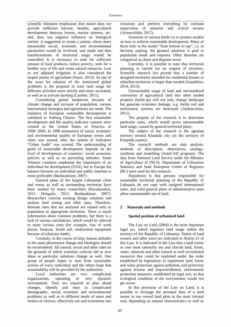
Under the general plan the coast is attributed to
range, which is suitable for usage of active
agriculture (Figure 1a) as soil is not sensitive to such
a process, when looking at the exploratory territory
from the agrarian perspective. Here large farms can
be established and various activities can be initiated.
Priority interests near Klaipėda city, towards
Kretinga and Gargždai (Figure 2b), include intense
agriculture, sparing forestry and extensive recreation. Priority interests in the northern part of the region,
towards Skuodas, are sparing forestry, sparing
agriculture and conservation established by
legislation. Priority interests in the south of the
region, towards Šilutė, are sparing forestry, intense
agriculture and extensive recreation.
Figure 1. The extract from the general plan of the Republic of Lithuania: a) Agrarian area, b) Functional zoning, c) Urban
framework
a) b)
c)
Gaudėšius
22
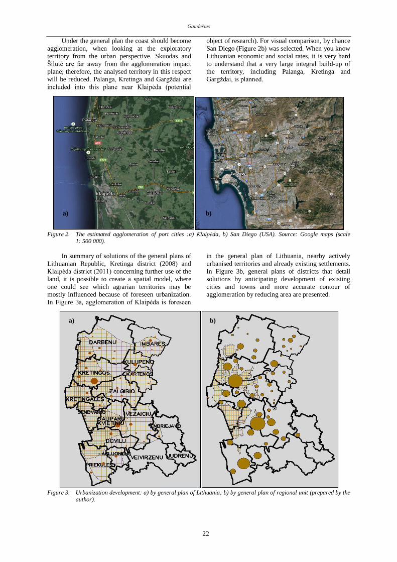
Under the general plan the coast should become
agglomeration, when looking at the exploratory
territory from the urban perspective. Skuodas and
Šilutė are far away from the agglomeration impact
plane; therefore, the analysed territory in this respect
will be reduced. Palanga, Kretinga and Gargždai are
included into this plane near Klaipėda (potential
object of research). For visual comparison, by chance
San Diego (Figure 2b) was selected. When you know
Lithuanian economic and social rates, it is very hard
to understand that a very large integral build-up of
the territory, including Palanga, Kretinga and
Gargždai, is planned.
Figure 2. The estimated agglomeration of port cities :a) Klaipėda, b) San Diego (USA). Source: Google maps (scale
1: 500 000).
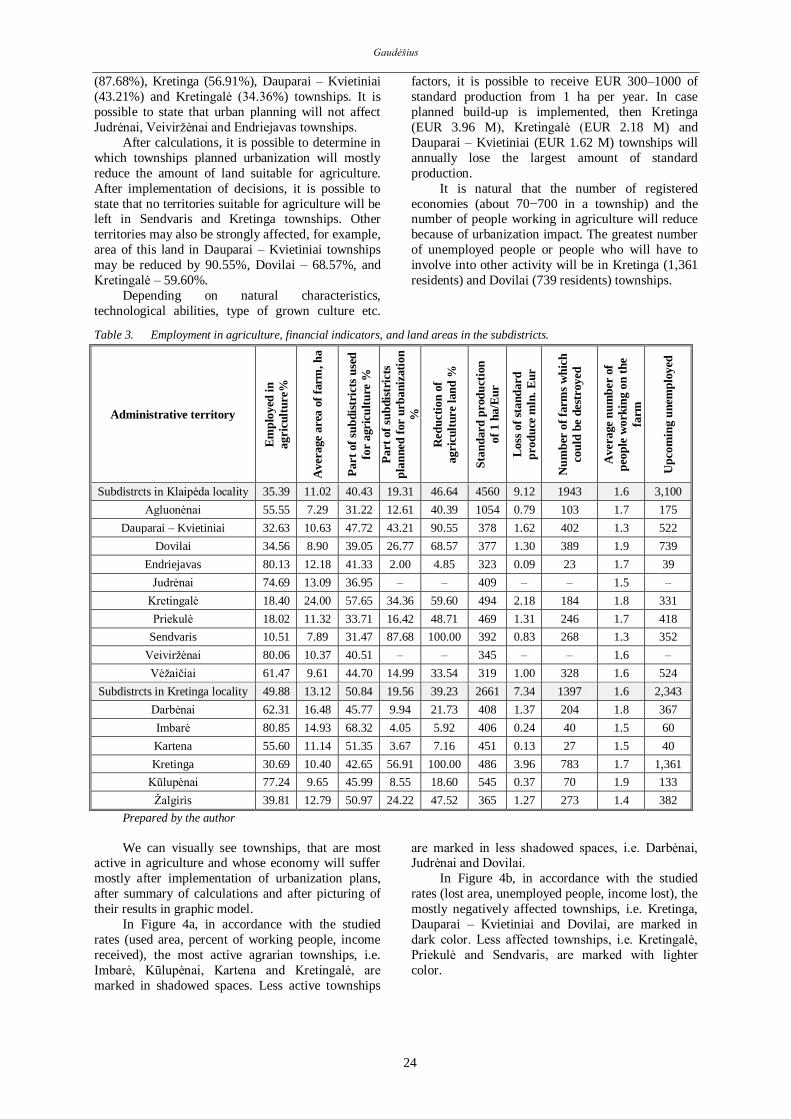
In summary of solutions of the general plans of
Lithuanian Republic, Kretinga district (2008) and
Klaipėda district (2011) concerning further use of the
land, it is possible to create a spatial model, where
one could see which agrarian territories may be
mostly influenced because of foreseen urbanization.
In Figure 3a, agglomeration of Klaipėda is foreseen
in the general plan of Lithuania, nearby actively
urbanised territories and already existing settlements.
In Figure 3b, general plans of districts that detail
solutions by anticipating development of existing
cities and towns and more accurate contour of
agglomeration by reducing area are presented.
Figure 3. Urbanization development: a) by general plan of Lithuania; b) by general plan of regional unit (prepared by the
author).
a) b)
a) b)

Influence of General Plans on Urbanization of Agrarian Territories on Lithuania’s Seaside
23
3 Results and discussion
According to the data announced by the
Statistics Department of the Republic of Lithuania
and the data of the National Land Service (Table 1
and 2), it is possible to calculate many important
rates (Table 3). In summary of the obtained results, it
is possible to assess the influence of solutions on
general plans.
Table 1. Distribution of the population in the subdistricts by age.
Administrative territory Total of whom Number of workers
in agriculture Aged
0–15
Working
age
Retirement
age
Subdistricts in Klaipėda locality 36,287 7,114 22,953 6,220 8,124
Agluonėnai 1,178 185 792 201 440
Dauparai – Kvietiniai 2,900 569 1,872 459 611
Dovilai 4,888 1,019 3,162 707 1,093
Endriejavas 1,675 261 1,032 382 827
Judrėnai 705 141 407 157 304
Kretingalė 4,736 965 3,086 685 568
Priekulė 7,829 1,536 4,815 1,478 868
Sendvaris 5,033 1,128 3,348 557 352
Veiviržėnai 3,055 517 1,786 752 1,430
Vėžaičiai 4,288 793 2,653 842 1,631
Subdistricts in Kretinga locality 20,720 3,742 12,603 4,375 6,287
Darbėnai 4,716 819 2,786 1,111 1,736
Imbarė 2,135 372 1,280 483 1,035
Kartena 1,719 251 1,061 407 590
Kretinga 7,198 1,371 4,434 1,393 1,361
Kūlupėnai 1,593 310 945 338 730
Žalgiris 3,359 619 2,097 643 835
Prepared by the author according to the data from Statistics Department.
Table 2. Agricultural activities in the subdistricts (farms, areas, produce).
Administrative
territory
Number of
farms
Land area used in
agriculture, ha
Plot of
subdistricts, ha
Plot of expected
urbanization, ha
Standard
produce, total,
M Eur
Subdistricts in Klaipėda locality
4,869 53,691 129,642 25,045 21.90
Agluonėnai 255 1,859 5,954 751 1.96
Dauparai - Kvietiniai 444 4,723 9,896 4,277 1.79
Dovilai 568 5,059 12,954 3,469 1.91
Endriejavas 477 5,811 14,058 282 1.88
Judrėnai 194 2,540 6,874 – 1.04
Kretingalė 309 7,419 12,868 4,422 3.67
Priekulė 506 5,731 16,999 2,792 2.69
Sendvaris 268 2,116 6,722 5,894 0.83
Veiviržėnai 869 9,019 22,260 – 3.12
Vėžaičiai 979 9,414 21,057 3,158 3.01
Subdistricts in Kretinga locality
3,754 49,289 98,853 19,341 21.11
Darbėnai 942 15,528 33,925 3,375 6.34
Imbarė 690 10,304 15,080 611 4.19
Kartena 386 4,301 8,375 308 1.94
Kretinga 783 8,147 19,101 10,871 3.96
Kūlupėnai 378 3,650 7,936 679 1.99
Žalgiris 575 7,359 14,436 3,497 2.69
Prepared by the author according to the data from Statistics Department and NLS.
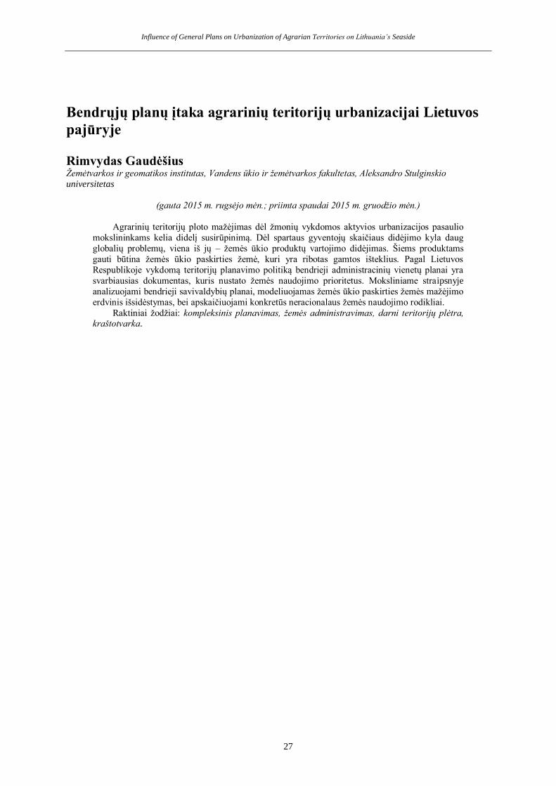
The calculations performed demonstrated that
the largest percentage of people involved in
agriculture were in Imbarė (80.85%), Endriejavas
(80.13%), Kūlupėnai (77.24%) and Judrėnai
(74.69%) townships, and the smallest percentage in
Sendvaris (10.51%), Priekulė (18.02%) ir Kretingalė
(18.40%) townships. Follwoing these results, we can
decide in which townships agricultural activity is
important to citizens as a living source.
The average area of a farm in different
townships differs from 7.29 ha (Agluonėnai
township) up to 24.0 ha (Kretingalė township). The
greatest part of township territory used for agriculture
is in Imbarė (68.32%), Kretingalė (57.65%), Kartena
(51.35%) and Žalgiris (50.97%) townships, and the
smallest part in Agluonėnai (31.22%), Sendvaris
(31.47%) and Priekulė (33.71%) townships.
The analysis of general plans of districts
showed that largest build-up is planned in Sendvaris
Gaudėšius
24
(87.68%), Kretinga (56.91%), Dauparai – Kvietiniai
(43.21%) and Kretingalė (34.36%) townships. It is
possible to state that urban planning will not affect
Judrėnai, Veiviržėnai and Endriejavas townships.
After calculations, it is possible to determine in
which townships planned urbanization will mostly
reduce the amount of land suitable for agriculture.
After implementation of decisions, it is possible to
state that no territories suitable for agriculture will be left in Sendvaris and Kretinga townships. Other
territories may also be strongly affected, for example,
area of this land in Dauparai – Kvietiniai townships
may be reduced by 90.55%, Dovilai – 68.57%, and
Kretingalė – 59.60%.
Depending on natural characteristics,
technological abilities, type of grown culture etc.
factors, it is possible to receive EUR 300–1000 of
standard production from 1 ha per year. In case
planned build-up is implemented, then Kretinga
(EUR 3.96 M), Kretingalė (EUR 2.18 M) and
Dauparai – Kvietiniai (EUR 1.62 M) townships will
annually lose the largest amount of standard
production.
It is natural that the number of registered
economies (about 70−700 in a township) and the number of people working in agriculture will reduce
because of urbanization impact. The greatest number
of unemployed people or people who will have to
involve into other activity will be in Kretinga (1,361
residents) and Dovilai (739 residents) townships.
Table 3. Employment in agriculture, financial indicators, and land areas in the subdistricts.
Administrative territory
Em
plo
yed
in
agri
cult
ure
%
Aver
age
are
a o
f fa
rm, h
a
Part
of
sub
dis
tric
ts u
sed
for
agri
cult
ure
%
Part
of
sub
dis
tric
ts
pla
nn
ed f
or
urb
an
izati
on
%
Red
uct
ion
of
agri
cult
ure
lan
d %
Sta
nd
ard
pro
du
ctio
n
of
1 h
a/E
ur
Loss
of
stan
dard
pro
du
ce m
ln.
Eu
r
Nu
mb
er o
f fa
rms
wh
ich
cou
ld b
e d
estr
oyed
Aver
age
nu
mb
er o
f
peo
ple
work
ing o
n t
he
farm
Up
com
ing u
nem
plo
yed
Subdistrcts in Klaipėda locality 35.39 11.02 40.43 19.31 46.64 4560 9.12 1943 1.6 3,100
Agluonėnai 55.55 7.29 31.22 12.61 40.39 1054 0.79 103 1.7 175
Dauparai – Kvietiniai 32.63 10.63 47.72 43.21 90.55 378 1.62 402 1.3 522
Dovilai 34.56 8.90 39.05 26.77 68.57 377 1.30 389 1.9 739
Endriejavas 80.13 12.18 41.33 2.00 4.85 323 0.09 23 1.7 39
Judrėnai 74.69 13.09 36.95 – – 409 – – 1.5 –
Kretingalė 18.40 24.00 57.65 34.36 59.60 494 2.18 184 1.8 331
Priekulė 18.02 11.32 33.71 16.42 48.71 469 1.31 246 1.7 418
Sendvaris 10.51 7.89 31.47 87.68 100.00 392 0.83 268 1.3 352
Veiviržėnai 80.06 10.37 40.51 – – 345 – – 1.6 –
Vėžaičiai 61.47 9.61 44.70 14.99 33.54 319 1.00 328 1.6 524
Subdistrcts in Kretinga locality 49.88 13.12 50.84 19.56 39.23 2661 7.34 1397 1.6 2,343
Darbėnai 62.31 16.48 45.77 9.94 21.73 408 1.37 204 1.8 367
Imbarė 80.85 14.93 68.32 4.05 5.92 406 0.24 40 1.5 60
Kartena 55.60 11.14 51.35 3.67 7.16 451 0.13 27 1.5 40
Kretinga 30.69 10.40 42.65 56.91 100.00 486 3.96 783 1.7 1,361
Kūlupėnai 77.24 9.65 45.99 8.55 18.60 545 0.37 70 1.9 133
Žalgiris 39.81 12.79 50.97 24.22 47.52 365 1.27 273 1.4 382
Prepared by the author
We can visually see townships, that are most active in agriculture and whose economy will suffer
mostly after implementation of urbanization plans,
after summary of calculations and after picturing of
their results in graphic model.
In Figure 4a, in accordance with the studied
rates (used area, percent of working people, income
received), the most active agrarian townships, i.e.
Imbarė, Kūlupėnai, Kartena and Kretingalė, are
marked in shadowed spaces. Less active townships
are marked in less shadowed spaces, i.e. Darbėnai, Judrėnai and Dovilai.
In Figure 4b, in accordance with the studied
rates (lost area, unemployed people, income lost), the
mostly negatively affected townships, i.e. Kretinga,
Dauparai – Kvietiniai and Dovilai, are marked in
dark color. Less affected townships, i.e. Kretingalė,
Priekulė and Sendvaris, are marked with lighter
color.

Influence of General Plans on Urbanization of Agrarian Territories on Lithuania’s Seaside
25
Figure 4. Subdistricts of Klaipėda region: a) the most active agrarian subdistricts; b) the most affected agrarian
subdistricts(prepared by the author)
In accordance with the data of Lithuanian
Statistics Department, the largest part of residents of
the analysed territory prefer living in houses (Figure
5a, 5b). 41% of Kretinga residents and 37% of
Klaipėda district residents live in blocks of flats. It
means that the demand for a separate house is great;
therefore, by using this “weakness”, the investors
have great influence on alteration of agrarian
territories for urbanization purposes.
Figure 5. Housing units: a) in Klaipėdadistrict; b) in Kretinga district (prepared by the author according to the data from
Statistics Department).
4 Conclusions and recommendations
The demand for agricultural products grows
together with the increase in the population. In
some countries, deforestation is performed as the
demand for agrarian territories increases. Depending on global problems, international
agreements are concluded. The aim of such
agreements is to save and use agrarian territories
as efficiently as possible. The situation in
Lithuania is different. Agrarian territories are
being destroyed under the banner of
development of settlements, which is used by
investors not under real demand. The worst thing
is that urban development performed by
architects does not observe principles of
international standards of sustainable
development because of preservation of cultural and agrarian territories.
Civil and environmental engineers, confronting
with plans of architects, note that they are
prepared only in consideration of demand of
investors; therefore, practical implementation of
such (artistic) images is not only difficult, but it
is also unreasonable from the society’s point of view. General territorial planning documents,
valid in the coastal region, planned to build-up
too large area of territory. In such a case,
townships (Kretingalė, Dovilai) that are still
active in agriculture may be destroyed by
experiencing both social (increase of
unemployment) and economic (lost production)
losses.
The study demonstrated that in case build-up of
agrarian territories by residential houses was
implemented then Kretinga district would
annually lose EUR 7.3 M and Klaipėda district would lose EUR 9.12 M of standard production
from agriculture, as well as 5,500 people of these
63%
37%
Conventional dvellings
One-dwelling building
Dwelling in an apartment building
59%
41%
Conventional dvellings
One-dwelling building
Dwelling in an apartment building
a) b)
a) b)

Gaudėšius
26
districts would lose their jobs (living source) or
would be forced to involve into other activity.
Lithuanian scientists talk much about problems
in territorial planning, but no particular
proposals are offered and state institutions do not
take any measures in order to stop this chaotic
urbanization. It is purposeful to reduce agrarian
territories which are foreseen to be urbanised in
general plans and in such a way to thicken build-up in territories of cities and towns. In such a
way, a chaotic situation of new residential
districts, damaging cultural landscape would be
reduced. Also there will be a possibility to
sustainably develop infrastructure of central
settlements by using less financial resources.
It is necessary to take measures in order to
strengthen the state control because of build-up
of agrarian territories, considering real needs, but
not plans of investors. Land management
specialists must be involved (in villages) when making final decisions (by supplementing
functions assigned by the National Land Service)
because of build-up in appropriate localities.
References
Aleknavičius Aleknavičius, P., Gaudėšius, R. (2011).
Klaipėdos miesto įtaka kaimiškųjų teritorijų žemės naudojimui [The influence of Klaipėda city to the usage of rural areas]. Darnaus vystymosi strategija ir praktika, 1(5), 52–63.
Arimavičiūtė, M. (2012). Lietuvos savivaldybių strateginio
planavimo problemos [Problems of strategic planning in Lithuania municipal]. Public policy and administration, 11(2), 272–286.
Bardauskienė, D., (2007). Ekspertinių vertinimų taikymas rengiant miesto bendrąjį planą [Assessments of Experts for the general plan development]. Ūkio technologinis ir ekonominis vystymas, 13(3), 223–236.
Brando, P. M., Coe, M. T., DeFries, R., & Azevedo, A. A.
(2013). Ecology, economy and management of an agroindustrial frontier landscape in the southeast Amazon. Philosophical transactions of the Royal society B, 368(1619). http://dx.doi.org/10.1098/rstb.2012.0152
Ceddia, M. G., Bardsley N. O., Palima S. G., & Sedlacek, S. (2014). Governance, agricultural intensification, and land sparing in tropical South America. Proceedings of
the National Academy of Sciences, 20 (111), 7242–7247.
Dringelis, L., Ramanauskas, E., & Gudzinevičiūtė, G. (2011). The use of land in master plans of towns from the point of view of sustainable spatial development. Environmental research, engineering and management, 4 (58), 65–73.
Eric, F. L. & Meyfroidt, P. (2011). Global land use change,
economic globalization, and the looming land scarcity. Proceedings of the National Academy of Sciences, 9(108), 3465–3472.
Gaudėšius, R. (2015). Old towns urban transformation and immovable cultural heritage in cityscape. Sustainable architecture and civil engineering, 1(10), 26–39.
Gaudėšius, R. (2014). Integrated development of rural areas in order to increase their competitiveness compared to urban areas. Environmental research,
engineering and management, 3 (69), p. 60–67.
Gaudėšius, R. (2013). Landscape architecture features in urban junction of Sendvaris district and Klaipėda city. Environmental research, engineering and management,
2(64), 72–80. Kavaliauskas, P. & Šabanovas S. (2011). New approach to
functional zoning in Kaunas city. Geografija, 47(2), 125–132.
The general plan of the territory of the municipality of Klaipėda district, approved by the order of Council of the municipality of Klaipėda district 24/02/2011, T11–111 [Klaipėdos rajono savivaldybės teritorijos
bendrasis planas, patvirtintas Klaipėdos rajono tarybos 2011 m. Vasario 24 d. Sprendimu Nr. T11–111]. Retrieved from: http://www.klaipedos–r.lt/?lt=1252479830. (Accessed: 2015–02–20).
The general plan of the territory of the municipality of Kretinga district, approved by the order of Council of the municipality of Kretinga district 18/12/2008, T2–322 [Kretingos rajono savivaldybės teritorijos
bendrasis planas, patvirtintas Kretingos rajono savivaldybės tarybos 2008 m. gruodžio 18 d. Sprendimu Nr. T2–322]. Retrieved from: https://www.kretinga.lt/node/318. (Accessed: 2015–08–20).
The general plan of the territory of the Republic of Lithuania, approved by the order of Seimas of the Republic of Lithuania 29/10/2002, IX–1154 [Lietuvos
Respublikos teritorijos bendrasis planas, patvirtintas Lietuvos Respublikos Seimo 2002 m. spalio 29 d. Nutarimu Nr. IX–1154]. Retrieved from: http://www3.lrs.lt/pls/inter2/dokpaieska.showdoc_l?p_id=284951. (Accessed: 2015–07–30).
The Law of the Republic of Lithuania on Territorial Planning [Lietuvos Respublikos teritorijų planavimo įstatymas]. Valstybės žinios, 1995, Nr. 107–2391.
The Law of the Republic of Lithuania on Land [Lietuvos
Respublikos žemės įstatymas]. Valstybės žinios, 2004, Nr. 28–868.
Sayer, J., Cassman K. G. (2013). Agricultural innovation to protect the environment. Proceedings of the National Academy of Sciences, 21(110), 8345–8348.
Influence of General Plans on Urbanization of Agrarian Territories on Lithuania’s Seaside
27
Bendrųjų planų įtaka agrarinių teritorijų urbanizacijai Lietuvos
pajūryje
Rimvydas Gaudėšius Žemėtvarkos ir geomatikos institutas, Vandens ūkio ir žemėtvarkos fakultetas, Aleksandro Stulginskio
universitetas
(gauta 2015 m. rugsėjo mėn.; priimta spaudai 2015 m. gruodžio mėn.)
Agrarinių teritorijų ploto mažėjimas dėl žmonių vykdomos aktyvios urbanizacijos pasaulio
mokslininkams kelia didelį susirūpinimą. Dėl spartaus gyventojų skaičiaus didėjimo kyla daug
globalių problemų, viena iš jų – žemės ūkio produktų vartojimo didėjimas. Šiems produktams
gauti būtina žemės ūkio paskirties žemė, kuri yra ribotas gamtos išteklius. Pagal Lietuvos
Respublikoje vykdomą teritorijų planavimo politiką bendrieji administracinių vienetų planai yra
svarbiausias dokumentas, kuris nustato žemės naudojimo prioritetus. Moksliniame straipsnyje
analizuojami bendrieji savivaldybių planai, modeliuojamas žemės ūkio paskirties žemės mažėjimo
erdvinis išsidėstymas, bei apskaičiuojami konkretūs neracionalaus žemės naudojimo rodikliai.
Raktiniai žodžiai: kompleksinis planavimas, žemės administravimas, darni teritorijų plėtra, kraštotvarka.