indonesia facility for disaster reduction’s risk and...
TRANSCRIPT

Completion Review of the Australia- Indonesia Facility for Disaster Reduction’s Risk and Vulnerability Program
March 2016

2
Review Report: This report was written jointly by a review team consisting of Lisa Roberts (independent consultant) and Dr. Jane Sexton (Geoscience Australia). The views and opinions expressed within it are those of the authors.
Acknowledgements:
The review team would like to express their deep appreciation to the DMInnovation team in Jakarta for managing the complex logistics associated with this review. The review team further wishes to express their gratitude to all Government of Indonesia (GoI) officials, research institutions, multilateral organisations, NGO’s, and civil society representatives for their time, and valuable inputs into the review process. Lastly, thank you to DFAT’s Disaster Management Unit (DMU) for sharing their perspectives on the disaster risk management (DRM) sector in Indonesia, and managing the administrative arrangements that made this review possible.
Aid Activity Summary
Aid Activity Name Australia-Indonesia Facility for Disaster Reduction - Risk and Vulnerability Program
Timeline July 2008 – August 2015 Budget for Risk and Vulnerability program
Total R&V 2008 – 2015 = $17,286,572.80 Total AIFDR 2008 – 2015 = $84,317,435.29
Delivery Organisation Geoscience Australia Implementing Partner(s) BIG, BG, BMKG, OSM, BNPB, BPBD (various), ITB, LIPI
Country/Region Indonesia Primary Sector Disaster Risk Management (DRM)

3
Box 1: Definitions
The following definitions for key terms used in this report are provided for clarity.
Contingency planning: a management process that analyses specific potential events or emerging situations that might threaten society or the environment and establishes arrangements in advance to enable timely, effective and appropriate responses to such events and situations.
Disaster risk: The potential disaster losses, in lives, health status, livelihoods, assets and services, which could occur to a particular community or a society over some specified future time period.
Disaster risk management: The systematic process of using administrative directives, organizations, and operational skills and capacities to implement strategies, policies and improved coping capacities in order to lessen the adverse impacts of hazards and the possibility of disaster.
Disaster risk reduction: The concept and practice of reducing disaster risks through systematic efforts to analyse and manage the causal factors of disasters, including through reduced exposure to hazards, lessened vulnerability of people and property, wise management of land and the environment, and improved preparedness for adverse events. Note that while the term “disaster reduction” is sometimes used, the term “disaster risk reduction” provides a better recognition of the ongoing nature of disaster risks and the ongoing potential to reduce these risks.
Risk Assessment: A methodology to determine the nature and extent of risk by analysing potential hazards and evaluating existing conditions of vulnerability that together could potentially harm exposed people, property, services, livelihoods and the environment on which they depend.
Comment: Risk assessments (and associated risk mapping) include: a review of the technical characteristics of hazards such as their location, intensity, frequency and probability; the analysis of exposure and vulnerability including the physical social, health, economic and environmental dimensions; and the evaluation of the effectiveness of prevailing and alternative coping capacities in respect to likely risk scenarios.
SOURCE: UNISDR retrieved from http://www.unisdr.org/we/inform/terminology
4
Contents
List of Acronyms ............................................................................................................................ 6
Executive Summary ..................................................................................................................... 10
Section 1: Introduction ................................................................................................................ 18
1.1 Indonesia's Disaster Profile ................................................................................................ 19
1.2. Indonesia's Disaster Management Governance Arrangements.......................................... 21
1.3. History of AIFDR ............................................................................................................... 22
1.4 R&V program logic ........................................................................................................... 25
1.5 Review Purpose ............................................................................................................... 28
1.6 Review Methodology ....................................................................................................... 29
1.7 Review Limitations and Constraints .................................................................................. 29
Section 2: Review Findings ........................................................................................................... 30
2.1 Findings against Evaluation Questions .............................................................................. 30
2.2 Summary of Review Findings: ........................................................................................... 51
2.3 Aggregate Review Ratings ................................................................................................ 52
Section 3: Lessons Learnt ............................................................................................................. 55
Section 4: Recommendations ...................................................................................................... 58
4.1 High Level Recommendations .......................................................................................... 58
4.2 Operational Level Recommendations: .............................................................................. 60
Conclusion: .................................................................................................................................. 61
Annex 1: Evaluation Plan ............................................................................................................. 63
Annex 2: Key evaluation questions and data methods ................................................................. 70
Annex 3: List of Documents ......................................................................................................... 72
Annex 4: Interviews and Interview focus ...................................................................................... 74
Boxes Box 1: Definitions 3 Box 2: Risk and Vulnerability Program Achievements 18 Charts Chart 1: Inform Risk Index for 2015 20 Chart 2: Distribution of disasters and people killed in Indonesia 21 Chart 3: Original AIFDR Program Logic 24 Chart 4: Disaster Management Cycle 27

5
Chart 5: Risk and Vulnerability projects alignment to preparedness and response 28 Tables Table 1: Summary Evaluation Criteria Ratings 13 Table 2: Evaluation Criteria Ratings 52

6
List of Acronyms
AHA ASEAN Coordinating Centre for Humanitarian Assistance on Disaster Management
AIFDR Australia-Indonesia Facility for Disaster Reduction
ANU The Australian National University
ARC Either: (1) Australian Research Council or (2) Australian Red Cross
ASEAN Association of Southeast Asian Nations
AusAID Australian Agency for International Development
AWI Alfred Wegner Institute
BIG Geospatial Information Agency
Badan Informasi Geospatial:
BG Geological Agency
Badan Geologi
BMKG Agency for Meteorology, Climatology and Geophysics (Indonesia): Badan Meterologi, Klimatologi dan Geofisika
BNPB National Disaster Management Agency
Badan Nasional Penanggulangan Bencana
BPBD Provincial and District Disaster management Agency:
Badan Penanggulangan Bencana Daerah
BPPT The Agency for the Assessment and Application of Technology
Badan Pengkajian dan Penerapan Teknologi
BOM Australian Government: Bureau of Meteorology
CDSP Capacity Development Support Program
CSO Civil Society Organisation
DEM Digital Elevation Model
DFAT Department of Foreign Affairs and Trade
DMInnovation Disaster Management Innovation
DM Disaster Management

7
DMU DFAT’s Disaster Management Unit
DRR Disaster Risk Reduction
DRU Disaster Response Unit
EOC Emergency Operation Centre
EWS Early Warning System
GA Geoscience Australia
GAR Global Assessment Report on Disaster Risk Reduction
GEM Global Earthquake Model
GFDRR World Bank Global Facility for Disaster Reduction and Recovery
GIS Geographical Information System
GoA Government of Australia
GoI Government of Indonesia
GREAT Graduate Research in Earthquakes and Active Tectonics (ITB program)
HOT Humanitarian OpenStreetMap Team
HPC High Performance Computer (or Computing)
IABI Indonesian Association of Disaster Experts
Ikatan Ahli Kebencanaan Indonesia
InaSAFE Indonesia Scenario Assessment for Emergencies
QGIS plugin for disaster managers
InaTEWS Indonesian Tsunami Early Warning System
InaWARE An advanced hazard early warning and monitoring system from PDC
IOM International Organisation for Migration
ITB Bandung Institute of Technology (Indonesia)
Jakarta DKI Province of Jakarta
Daerah Khusus Ibukota Jakarta
JATWC Joint Australian Tsunami Warning Centre (Managed by GA and BOM)
Kelurahan See below for Description of Relevant Area Classifications
KKP Ministry of Marine and Fisheries

8
LIPI Indonesian Institute of Sciences
Lembaga Ilmu Pengetahuan Indonesia
MOU Memorandum of Understanding
NGO Non Government Organisation
NTT Nusa Tenggara Timur (East Nusa Tenggara – Indonesian Province)
NU Nahdlatul Ulama (faith based organisation with strong community programs)
ODA Official Development Assistance
OSM OpenStreetMap
PacSAFE Impact scenario tool for disaster managers in the Pacific region/based on InaSAFE and QGIS
PDC Pacific Disaster Centre
PSHA Probabilistic Seismic Hazard Analysis
PTHA Probabilistic Tsunami Hazard Analysis
PU Public Works
QGIS Open Source GIS program
R&V AIFDR Risk and Vulnerability Program
SPC Secretariat of the Pacific Community
TATTs Technical Assistance and Training Teams – a USAID funded program through Mercy Corps – Cardno US
T&O AIFDR Training and Outreach Unit
UGM Universitas Gadjah Mada
UNDP United Nations Development Program
UN ISDR United Nations Office for Disaster Reduction
UN OCHA United Nations Office for the Coordination of Humanitarian Affairs
UoW The University of Wollongong
UPT-BNPB BNPB Regional Training and Logistics Training centres – also known as Regional Technical Implementation Units – AIFDR built the one in Padang
USGS United States Geological Survey

9
VAAC Volcanic Ash Advisory Centre
WB World Bank
WebSAFE Impact scenario tool for disaster managers in the Philippines/based on InaSAFE and QGIS
Kelurahan explained: An administrative village (Indonesian: Kelurahan) is the lowest level of government administration in Indonesia. A village is divided into several community groups (rukun warga – RW) which are further divided into neighbourhood groups (rukun tetangga – RT).

10
Executive Summary Background:
The Risk and Vulnerability Program (R&V) that is the subject of this completion review was one of three work streams or ‘components’ under the Australia-Indonesia Facility for Disaster Reduction (AIFDR). The Facility was established in response to a political commitment made by former Prime Minister of Australia, Kevin Rudd, and former President of Indonesia, Susilo Bambang Yudhoyono, to work together to support strengthening the region’s disaster management capabilities. Contrary to AIFDR’s intended regional focus, it subsequently provided primarily bi-lateral support to Indonesia, with only a small level of regional engagement via support to the Association of Southeast Asian Nations (ASEAN). The R&V program was funded by the Australian Government and implemented by Geoscience Australia (GA). The rationale for the investment was to increase the use of world class science in Indonesia to support evidence-based decision making on disaster risk reduction (DRR).
The R&V program comprised of a range of discrete projects aligned to the high-level logic of the facility. The program itself had no theory of change, nor documented expected outcomes. The scope of the program, and number of partners grew as opportunities arose over time. The program was managed by a small GA team based in Jakarta, who both deployed their specialist expertise on relevant projects, and drew on additional Australia-based GA experts as required.
The work program covered:
• Building the capacity of Indonesian scientists to better understand the nature of natural hazards including size, severity, recurrence and their spatial footprint;
• Facilitating science partnerships across Government of Indonesia (GoI); and between GoI and academic research institutions for more effective science collaboration;
• Providing high-performance computing infrastructure and fundamental data to support sophisticated hazard modelling;
• Providing academic scholarships to address skills gaps in science, and develop Indonesia’s future leaders of science;
• Developing and disseminating tools for integrating science into contingency planning and risk assessment processes.
R&V was a complex program that saw GA working simultaneously across three geological hazard types (volcano; earthquake and tsunami); developing both science products and tools: and, nurturing innovation in open source data technologies.

11
A follow up science program has commenced called DMInnovation. The program is implemented by GA, and funded by the Department of Foreign Affairs and Trade (DFAT). DMInnovation aims to build upon the achievements of the R&V program.
Review Activities:
The focus of this completion review is on the macro level of the R&V program. It is concerned with program achievements, lessons learnt, and an assessment of the ‘take up’ of the R&V science products and tools by disaster managers in Indonesia. The program is being assessed against three criteria: relevance, effectiveness, and sustainability by addressing five high-level evaluation questions.
To ensure objectivity the review is led by an independent consultant, Lisa Roberts, who is an experienced DRM evaluator. Dr Jane Sexton from GA provides specialist scientific expertise as the second evaluator. Although Dr Sexton is a GA staff member she has not been directly involved in the R&V program, so although not fully independent can be said to be operating at ‘arms-length’.
Given key drivers for this review are learning and knowledge generation the review team worked closely with the primary end users (GA’s program team) to ensure both the review process and outputs are operationally relevant and useful. The review team drew upon a range of data sources for this review to ensure validation through cross verification from two or more sources (e.g. data sources include: semi-structured interviews; workshop; documents; observation and trialling of science tools). The team consulted over 80 individual stakeholders in Jakarta and Bandung between 26 October and 6 November 2015. A small number of follow up consultations occurred with stakeholders not based in Indonesia. For more detailed information about the review process please see the Evaluation Plan at Annex 1.
Summary of Review Findings:
• GA’s science program remains highly relevant to the policies of the Governments’ of both Indonesia and Australia, and more specifically to the target group of Indonesian science and disaster management agencies. Evidence shows uptake of science by disaster managers at the national level has increased over the course of the R&V program.
• Australia has reaped high political value in the people-to-people links established through the R&V program. Relationships are now firmly established between senior Australian and Indonesian scientists, and Australian Research Institutions and GoI. Show-casing Australian science expertise in Indonesia through the R&V program, and now through DMInnovation, provides political dividends for GoA.

12
• Evidence shows uptake of science by disaster managers’ at the sub-national level is mixed, and depends significantly upon the skills, capacity and resourcing of provincial and district disaster management agencies called Badan Penanggulangan Bencana Daerah, (BPBD).
• There is evidence of non-government organisation (NGO) and civil society science uptake in risk assessment and contingency planning for disaster risk management (DRM).
• Evidence shows science uptake beyond the disaster management sector in a range of areas: mapping of administrative boundaries; selection, design and construction of infrastructure assets; public health; and urban planning.
• There are gaps in understanding amongst disaster managers on the full spectrum of how the existing science supports the disaster management cycle.
• More planning by GA is needed to continue the uptake of the science products and tools by disaster managers.
• Future risk assessments will require the development of vulnerability information1. • There is a heavy dependency by numerous GoI science agencies on Australian-
provided high speed computing infrastructure. • There is a dependency by GoI science agencies and research institutes on GA to
facilitate inter-agency science collaboration. • The Graduate Research in Earthquakes and Active Tectonics (GREAT) program is
highly effective, and is producing home grown Indonesian leaders in science. GREAT is moving towards being financially self-sustaining.
• OpenStreetMap (OSM) and Indonesia Scenario Assessment for Emergencies (InaSAFE) training has been well received by government and non-government stakeholders, but targeting needs to be improved to increase reach and sustainability.
• GoI science agencies are deriving high value from GA twinning and mentoring arrangements.
• A major gap in R&V training is in data and information management systems. • Connectivity between the R&V program and AIFDR’s other programs occurred late in
the life of AIFDR and with mixed results. Evidence shows a high level of connectivity between the Training and Outreach program and R&V. A lower level of connectivity occurred between the Partnerships program and R&V program.
1 Risk assessment relies on an understanding of the hazard (how often, how large), the exposure (what elements in the built environment are exposed to the hazard, e.g. buildings, schools, people) and vulnerability (how those exposure elements respond to the level of hazard).

13
• Products of the R&V program have made a valuable international contribution to DRR, and humanitarian action. InaSAFE and OSM Tasking Manager are being implemented in other countries.
Review Ratings:
The review team’s aggregate ratings of the R&V program against the OECD DAC’s evaluation criteria2 for development assistance are summarised in the table below. The rating scale of 1-6 used in this review is DFAT’s standard scale for performance reviews. Ratings are explained as follows: 6 = very good; achieved or exceeded objectives and outcomes. 5 = good; major objectives achieved and substantial progress towards achieving outcomes. 4 = adequate; some objectives achieved and measurable progress towards outcomes. 3 = less than adequate; outputs delivered but less than satisfactory progress towards outcomes. 2 = poor; although there is some evidence of progress, the investment did not achieve its objectives or outcomes. 1 = very poor; objectives and outcomes not achieved.
Table 1: Evaluation Criteria Ratings
Evaluation Criteria
Rating (1-6) Comments
Relevance 6
Overall, the Government of Australia’s (GoA) science investment is highly relevant to the development priorities of Indonesia, and the needs of the science sector. The investment aligns strongly with Australia’s international commitments to the Sendai framework, and bi-lateral aid policy settings for Indonesia. Australia has reaped high political value in the people-to-people links established through the R&V program,
2 This review is informed by the OECD’s Development Assistance Committee’s (DAC) criteria for evaluating development assistance. OECD DAC criteria for relevance; effectiveness, and sustainability are as follows: “Relevance: The extent to which the aid activity is suited to the priorities and policies of the target group, recipient and donor. Effectiveness: A measure of the extent to which an aid activity attains its objectives. Sustainability: Sustainability: is concerned with measuring whether the benefits of an activity are likely to continue after donor funding has been withdraw” see further Source: http://www.oecd.org/dac/evaluation/daccriteriaforevaluatingdevelopmentassistance.htm

14
and show-casing of Australian science expertise in Indonesia. Also, Australia has leveraged through the R&V program a profile as a donor who backs innovation – this is attributable to R&V’s funding of the latest in open source data technologies for geospatial mapping in Indonesia.
Effectiveness 5
Overall, the R&V program rates highly in terms of effectiveness. Although, not all projects under the work program are equally effective. There are individual projects the review team consider are outstanding despite the modest size of these investments (see Text Box 2 Risk and Vulnerability Program Achievements).
Sustainability 4
The R&V program does not rate as highly against the sustainability criteria. A modest rating is given for sustainability as the evidence suggests many of the discrete projects are not yet fully sustainable. Moving forward, GA should devise project exit strategies as appropriate.
Summary of Review High Level Recommendations:
Re-examine what the best policy fit is for GoA’s science investment within Australia’s revised Official Development Assistance (ODA) policy settings. There are a range of options DFAT could pursue in terms of framing the science investment, including:
Option 1: Science for disaster management (maintaining the current way the investment is framed);
Option 2: Science for infrastructure and economic growth (re-framing the GA science
program as a contribution to infrastructure and economic growth agendas); Option 3: Science as a fundamental pre-requisite for sustainable economic
development, and therefore as an investment with multi-sectoral development implications and potential impacts (re-framing the GA science program as a multi-sectoral contributor).
Rethink the target group for the GA science program: R&V was operationally dependent on AIFDR’s other work streams to transfer the science to disaster managers. Without DMInnovation being supported by complementary development programs, it will be very

15
difficult for the small GA team to sustain even the most modest level of science transfer to disaster management decision makers without either: (1) the DFAT Disaster Management Unit (DMU) actively facilitating the connections; and/or (2) partnering with other donor programs that can facilitate interconnectivity. If support is unavailable to GA the review team recommends revising DMInnovation’s work program to focus all effort at the national level – targeting and partnering only with GoI science agencies. These GoI science agencies would no longer be supported by Australia to transfer science products to DRM decision makers. Scale back the GA work program: The number of projects and partnerships should be scaled back to a more manageable number given the reduced program budget. Through rationalisation the small program team can be freed up to address program and performance management weaknesses, and spend more time on relationship management.
Document a clear program logic: DMInnovation needs to document its program logic. The review team suggest DMInnovation develop a communication plan, that may include for example, a short two page flyer outlining the logic of the program that can be shared with stakeholders.
Strengthen program management systems: The scope of the R&V work program developed primarily opportunistically, and consequently the attention given to maintaining robust program management systems was sub-optimal. DMInnovation needs to strengthen annual work plans, and monitoring and evaluation systems.
Clarification of roles between DFAT and GA: Since the closure of AIFDR there is confusion over the division of management responsibilities for the R&V program between DFAT and GA. Increased inter-agency management planning would be highly beneficial to the new GA program (DMInnovation).
Operational Level Recommendations:
The following activities are recommended for GA in order to: • improve the sustainability of hazard map development and exposure data collection; • improve the effectiveness of the hazard maps and exposure data; • improve the sustainability and effectiveness of impact and risk analysis tools,
including InaSAFE; and • position GoI science agencies to develop hazard risk information.
1. Hazard mapping:
a. GA to support Badan Geologi (BG) and the Agency for Meteorology, Climatology and Geophysics (BMKG) to identify a local sustainable solution to meet their high performance computing needs

16
b. GA to support the development of a strategy to source critical input data for hazard modelling (e.g. forecast wind fields for volcanic ash and elevation data for tsunami modelling)
c. GA to support the development of guidelines to enable disaster managers to source hazard information
d. GA to support BG to develop a communication strategy for the promotion of hazard maps (including a narrative on why planning cannot rely solely on what has been happening in the past)
e. GA to propose the development of a Memorandum of Understanding (MOU) to BMKG and BG for volcano ash (similar to that for earthquakes) to clearly articulate the respective roles and responsibilities of the science agencies and a good governance process for map development and review
2. Exposure data: a. GA to collaborate with groups like the World Bank to propose the
development of guidelines for participatory mapping that supports validation and legalisation by governments, to key government stakeholders
b. GA to work with Humanitarian OpenStreetMap Team (HOT) to introduce metadata requirements for OSM data collection to meet national open data policies
c. GA to work with disaster managers to identify a responsible owner for the revision of OSM data for disaster management purposes
3. Vulnerability data:
a. GA to support ITB to promote the requirement for the development of fragility curves for earthquake, tsunami and volcanic ash to the National Disaster Management Agency (BNPB) as a necessity to support cost-benefit analysis of mitigation actions
4. Data management: a. GA to promote the value of good practice data and information management
to GoI science agencies b. GA to facilitate connection between BNPB, Badan Informasi Geospatial (BIG)
and the science agencies to improve discoverability and accessibility of the hazard data (ideally via webservices)
c. GA to promote the use of open standards and formats for data delivery to GoI science agencies
5. InaSAFE:

17
a. GA to implement a Training of Trainers (TOT) activity for a range of actors beyond the universities for OSM and InaSAFE
b. GA to broaden participation in InaSAFE training to include key actors in the DM space (i.e. NGOs and GoI science agencies)
c. GA to enhance InaSAFE training to promote the integrated nature of impact and risk analysis process and map the input data with data providers (e.g. earthquake hazard to BG)
d. GA, in collaboration with partners, to determine the feasibility of online delivery of InaSAFE
e. GA to increase brand recognition of InaSAFE over the open source GIS program, QGIS, and promote GoA investment
f. GA to continue to leverage other disaster management projects, (e.g. USAID programs with PDC re InAWARE and potentially PetaJakarta), and actively partner where appropriate.

18
Lessons Learnt
Box 2: Risk and Vulnerability Program Achievements
• R&V facilitation of Indonesia’s first ‘best practice’ national earthquake hazard map in 2010, and the introduction of a best practice governance model for inter-agency collaboration to update the map.
o National earthquake hazard map being institutionalised by the Department of Public Works for informing national building codes for infrastructure.
• R&V Technical support to Badan Geologi to prepare real-time volcanic ash models using open-source tools. Badan Geologi’s volcanic ash capability prior to this collaboration related to mapping of historical events with limited capability in volcanic ash modelling itself. The economic and public health impacts of this work are potentially of high development significance.
• Building science educational capacity in Indonesia: R&V helped to establish the GREAT program at the Institute of Technology (ITB) in Bandung. The driver for the program was to create a program of study in Indonesia to address significant skills gaps in the geological sciences. The program has now produced a cadre of science leaders and made inroads into addressing some skills gaps. GREAT now leverages funding from the Ministry of Education and several Technical Agencies. GREAT has several international students now attending from South East Asia (eg. Cambodia and Burma). Next year GREAT intends to expand its focus to multi-hazards, and establish educational curriculum aligned with the specific needs of disaster managers.
• R&V funding supporting the development of a proof of concept for the tasking manager function in OpenStreetMap: this tasking manager is being used globally by humanitarian actors in response operations.
• R&V supporting development of fundamental and open data: For the first time in Jakarta’s 400 year history, not only have the administrative boundaries (at RW and RT levels) been spatially mapped, but the mapping process engaged government and community officials resulting in a government and community endorsed open data set.
• R&V contributing to a cultural shift in BNPB to value the use of reliable evidence-based data sets for disaster management.
• The InaSAFE tool exploits the investment in science to develop data for disaster management planning and response: the hazard and exposure data developed through the R&V program can be integrated seamlessly in this open source tool to develop evidence based risk assessments and contingency plans.

19
Section 1: Introduction
1.1. Indonesia's Disaster Profile
Indonesia faces the complex challenge of having a very high number of hazards and a highly vulnerable population due to widespread poverty, rapid urbanisation, population pressures, and sensitive eco-systems. According to a global risk analysis by the World Bank, “Indonesia is among the top 35 countries that have high mortality risks from multiple hazards. About 40 percent of the population is at risk, that is, more than 90 million lives”3. GoI “spends between US$300-500 million annually on post-disaster reconstruction, with spending during major disaster years reaching 0.3 percent of the national gross domestic product (GDP); and as high as 45 percent at the provincial level”4
The economic costs of disaster impacts at the provincial level is staggering for example: the economic impact of the Indian Ocean Tsunami in Aceh was estimated at US$4.5 billion or 54% of provincial and 1% of national GDP; and, earthquake events in Yogyakarta (2006) and West Sumatra (2009) resulted in estimated losses of US$3.1 billion and US$2.3 billion, representing 41% and 31% of regional GDP respectively5.
Indonesia’s resilience to natural disasters has significantly reduced over the last decade due to rapid demand for construction of houses and commercial buildings in urban areas with weak compliance of zoning regulations and building codes. Future projections of disaster losses estimate losses in the vicinity of “US$420-500 million per year and that once every 100 years these losses are close to US$1.5-1.6 billion”6.
3 See World Bank, Natural Disaster Hotspots, A Global Risk Analysis (Washington, DC: Disaster Risk Management Series, 2005) 4 World Bank Country Profile for Indonesia at pg.1 available at http://www.gfdrr.org/sites/gfdrr/files/region/ID.pdf 5 See World Bank ‘Indonesia Development Policy Review: Indonesia Avoiding the Trap” May 2014 at page 150, available at http://www.worldbank.org/content/dam/Worldbank/document/EAP/Indonesia/Indonesia-development-policy-review-2014-english.pdf 6 See World Bank ‘Indonesia Development Policy Review: Indonesia Avoiding the Trap” May 2014 at page 150,
20
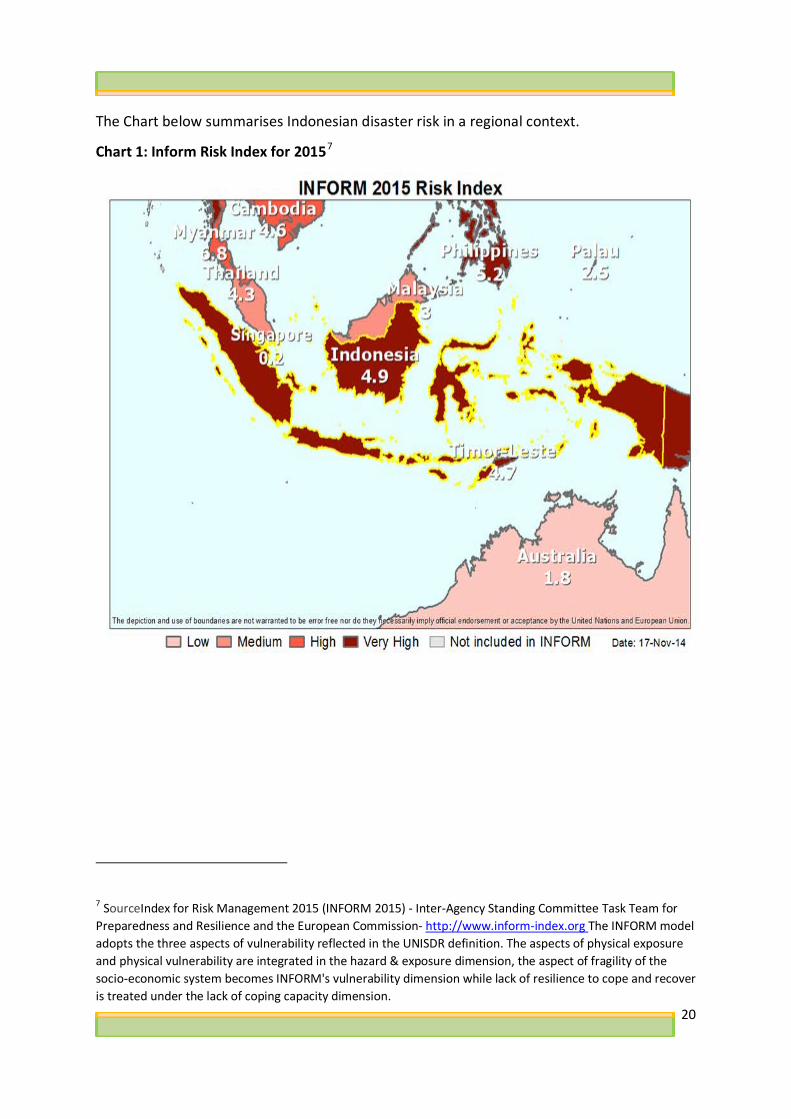
The Chart below summarises Indonesian disaster risk in a regional context.
Chart 1: Inform Risk Index for 20157
7 SourceIndex for Risk Management 2015 (INFORM 2015) - Inter-Agency Standing Committee Task Team for Preparedness and Resilience and the European Commission- http://www.inform-index.org The INFORM model adopts the three aspects of vulnerability reflected in the UNISDR definition. The aspects of physical exposure and physical vulnerability are integrated in the hazard & exposure dimension, the aspect of fragility of the socio-economic system becomes INFORM's vulnerability dimension while lack of resilience to cope and recover is treated under the lack of coping capacity dimension.

21
Chart 2: Distribution of disasters and people killed in Indonesia8
1.2. Indonesia's Disaster Management Governance Arrangements
Indonesia did not have a dedicated DRM law or disaster management agency until 2007-08. The country’s first DRM law was introduced in 2007 (Law 24/2007), and was driven largely by international policy, in particular, the Hyogo Framework of Actions (HFA’s) promotion of domestic laws and regulations for risk reduction. Indonesia’s new law decreed a dedicated national disaster management agency called BNPB, and sub-national disaster management agencies called BPBDs. BNPB has developed fast, increasing its credibility and profile within GoI. The Head of BNPB reports directly to the President of Indonesia, providing high-level political access.
At provincial and district levels disaster management agencies (BPBDs) have been established to coordinate efforts before, during and after a disaster. All 34 provinces have established BPBDs. Reportedly, 388 out of 4919 district BPBDs have been established10. Analysis commissioned by Australia found these relatively new agencies to be poorly financed and lacking technical capacity11. Commonly, provincial and district BPBDs rely on central government funding which is often limited. Sub-national BPBDs usually receive less than 1% of the provincial or district budget and rarely receive activity and/or program funding, yet are tasked with implementing risk assessments and contingency plans. 8 Source BNBP website at: www.bnpb.go.id 9 BNPB website
10 It is worth noting that under Indonesia’s DRM law Provincial BPBD’s are compulsory, whereas district BPBD’s are not.
11 Pellini 2013, You have to know who lives in danger; Universalia 2013, Improving Performance of Disaster Management Agencies in Indonesia: Rapid Organisational Assessments of BNPB and BPBD.
22
According to the World Bank, GoI’s budget for disaster management channelled through “BNPB increased by 500 percent between 2010 and 2014. BNPB also channeled US$233 million—including 50 percent for on-call emergency fund and 50 percent for reserve funds. Although it increased, budget allocation for disaster management is still below one percent of the total national budget as set in the global commitment”12.
DRM coordination is highly complex in Indonesia as up to 37 ministries and agencies at the national and sub-national level deliver services before, during and after a disaster.13 In addition, a range of non-government and faith-based organisations are actively involved in DRM, along with private sector companies.
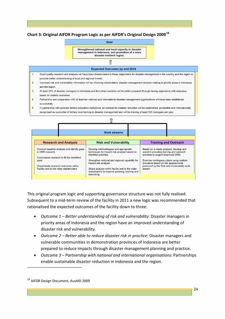
1.3. History of AIFDR AIFDR was born out of a political commitment between former Prime Minister of Australia, Kevin Rudd, and former President of Indonesia, Susilo Bambang Yudhoyono. The partnership was formally announced at the Asia-Pacific Economic Cooperation (APEC) meetings in 2008, and the facility became operational in 2009. The drivers behind AIFDR are multifactorial: (i) Australia and Indonesia recognizing regional gaps in DRM coordination, mitigation and preparedness; and (ii) a desire on behalf of Indonesia to increase its capability to self-manage large scale disaster responses. From the outset of AIFDR the GA science input was seen as a critical component of the overall investment. The rapid feasibility study undertaken for AIFDR stated: “The Partnership would comprise Australian and Indonesian collaboration on innovative scientific solutions and forward looking analysis to build more effective disaster mitigation, preparedness and response in Asia, including through APEC and ASEAN”. As mentioned earlier, AIFDR quickly took on primarily a bi-lateral focus with a very modest level of funding provided to the ASEAN Secretariat and AHA Centre to advance regional DRM coordination efforts. A design for AIFDR was commissioned in 2009. The design set out a program logic described as ‘flexible’ and ‘emergent’. Efforts to achieve the AIFDR goal, and expected outcomes were to occur through three linked work streams: research and analysis; risk and vulnerability; and training and outreach. The work streams are described below:
• “The research and analysis14 work stream: will deliver high-quality, prioritised research relevant to the AIFDR goal and outcomes and focused on emerging regional
12 World Bank Country Profile for Indonesia at pg.2 available at http://www.gfdrr.org/sites/gfdrr/files/region/ID.pdf 13 BNPB 2013, 5 Tahun BNPB: Tumbuh, Utuh, Tangguh
14 A DFAT Representative advised the review team that after AIFDR became operational the ‘Research and Analysis’ works stream became commonly known as the “Research and Innovation’ work stream.
23
threats in Asia. Its work will also include policy and organisational research and will facilitate access to scholarships for study at technical, graduate and post-graduate level that will help develop a cadre of professional disaster managers in the region.
• The risk and vulnerability work stream: will use world class science to quantify hazards in Indonesia and Asia and compute risk based upon exposure and vulnerability. Expertise for this work will be provided by Geoscience Australia in collaboration with other technical organisations in Indonesia and the region.
• The training and outreach work stream: will deliver targeted and high-quality training through the collaborative identification of priority training needs, engagement of the best and most appropriate expertise to develop customised training packages and provision of a venue and training mechanisms”15.
According to AIFDR’s original design the program logic was that the three work streams would work coherently from the start to contribute to the overarching goal of “strengthened national and local capacity in disaster management in Indonesia and promotion of a more disaster resilient region”16. As noted in the design document “if the AIFDR fails to capture the synergies between the three streams, if the whole is not greater than the sum of its parts, the AIFDR will not realise its objectives fully”17. AIFDR’s work programs were intended to be developed annually by AIFDR staff. These were to be reviewed and amended by a senior level Executive Committee with Indonesian and Australian members. The committee was to be supported by an Implementation and Technical Working Group that would provide more detailed oversight and guidance.
15 AIFDR Design Document, AusAID 2009 16 AIFDR Design Document, AusAID 2009 17 AIFDR Design Document, AusAID 2009
24
Chart 3: Original AIFDR Program Logic as per AIFDR’s Original Design 200918
This original program logic and supporting governance structure was not fully realised. Subsequent to a mid-term review of the facility in 2011 a new logic was recommended that rationalised the expected outcomes of the facility down to three:
• Outcome 1 – Better understanding of risk and vulnerability: Disaster managers in priority areas of Indonesia and the region have an improved understanding of disaster risk and vulnerability.
• Outcome 2 – Better able to reduce disaster risk in practice: Disaster managers and vulnerable communities in demonstration provinces of Indonesia are better prepared to reduce impacts through disaster management planning and practice.
• Outcome 3 – Partnership with national and international organisations: Partnerships enable sustainable disaster reduction in Indonesia and the region.
18 AIFDR Design Document, AusAID 2009

25
The research and analysis work stream was dropped, and a ‘partnerships’ work stream established around the time of the mid-term review. As the evaluation of AIFDR Phase 1 stated: “The first two years of AIFDR effectively represent an ‘exploration phase’ where the AIFDR team were trying to understand the DRM context in Indonesia, cement a partnership with BNPB, and identify AIFDR’s comparative advantage. From around the time of the Mid-Term-Review, AIFDR took on a more programmatic approach. At this point there appears to have been concerted efforts made by the three work streams to identify synergies and opportunities for collaborative programming”19.
1.4 R&V program logic Science investment was central to AIFDR’s program logic. The rationale was that without Indonesia having access to, or generating, reliable world class hazard data the country’s efforts in disaster risk reduction would remain limited. There was no documented theory of change at the facility level or work stream level. The review team surmise the R&V program logic as: the R&V program would support the development of reliable science products, and AIFDR’s complementary ‘Partnerships’ and ‘Training and Outreach’ work streams would be the vehicles by which the science products would be transferred to disaster managers to inform evidence-based risk assessment and contingency planning processes that in turn would mitigate disaster risk, and strengthen disaster preparedness efforts of government and communities.
GA leveraged pre-existing person-to-person links between Australian and Indonesian scientists to create an entry point for the R&V program. The review team tried to locate a feasibility or gap analysis study for the R&V program with no success. It appears no feasibility analysis was undertaken prior to commencement of the program.
The initial focus of the R&V program was translating GA’s domestic experience in hazard modelling to inform and strengthen Indonesia’s capacity across three geological hazard types: earthquake, volcano, and tsunami. GA provided experts across all three hazards. From the very start of AIFDR the R&V program was opportunistic in its approach. R&V’s work program expanded as opportunities presented, through requests for assistance, and stemming from GA staff following areas of interest/expertise. This may not be an entirely accurate interpretation of history, but the review team found no evidence to discount it. R&V made a significant programmatic shift when it moved from a focus on building the capacity of Indonesia’s science organisations to produce reliable science products (hazard
19 AIFDR: Review of Phase 1 Report, Department of Foreign Affairs and Trade, August 2014

26
maps, and probabilistic models) to building of science tools (InaSAFE) and investments in open data source capabilities (e.g. OSM and PetaJakarta). The rationale for the shift is not well documented, but anecdotally the review team were advised that it was to ensure translation of science outputs into products fit for use by disaster managers. The review team were advised that the InaSAFE tool has been valuable in winning influence with disaster managers regarding the benefits of using science in DRM. A significant challenge the review team confronted was the lack of documented overall logic for the R&V program, and the absence of an articulation of how each discrete project contributes to the disaster management cycle. This is sub-optimal for performance management as it is unclear how the project goals of each discrete activity contribute towards the program’s high order goal.
The review team has developed two charts; Chart 4 shows how the R&V program has contributed to building the capacity of GoI science agencies to support disaster management in Indonesia. The R&V program has consisted of activities that have:
• built technical capability (purple section), • provided data and infrastructure to support the science activities (green section) • develop science products (blue section)
to ultimately contribute to the disaster management cycle (maroon section). Chart 5 summarises how R&V projects align with the response and preparedness phases of the disaster management cycle. This Chart is relevant to both the R&V Program, and to DMInnovation.

27
Chart 4: Disaster Management Cycle

28
Chart 5: Project alignment with disaster response and preparedness phases
1.5 Review Purpose This review focuses on the R&V program from its inception in 2009, until its completion in August 2015. The program is assessed for relevance, effectiveness and sustainability using five high level evaluation questions. The focus is on the macro level of the R&V program examining program outcomes, lessons learnt, and assessing the ‘take up’ of the R&V science information by Indonesian DM decision makers. It does not focus on the micro level of assessing individual program activities, but with that said it examines the interconnectivity between individual program activities.
The team were tasked by GA and DFAT to answer five high level evaluation questions, namely:
1. What was the rationale for the original program, and to what extent does it remain relevant to the Indonesian context?

29
2. To what extent did the R&V led activities result in disaster managers making better use of science information and spatial data? What were the limitations to using science?
3. Which R&V initiated training and capacity building programs have been effective? Have they targeted the correct individuals/groups and to what extent have participants adopted new practices, and are these likely to be sustained?
4. To what extent did R&V successfully engage other disaster management programs delivered through AIFDR programs and combine local and expert knowledge to successfully deliver science to Indonesian DM decision makers?
5. To what extent are R&V programs initiated in Indonesia influencing the international DRM community?
Given that key drivers for this review are learning and knowledge generation to inform the new DMInnovation program, the review team worked closely with the primary end users (GA’s program team) to ensure the data gathered and the final review report would meet their operational needs. The review team regularly consulted, and debriefed with Dr David Robinson (DMInnovation Manager) throughout the review process.
1.6 Review Methodology The review team used a mixed method qualitative approach drawing upon a range of data sources, including: document review; timeline analysis; semi-structured individual and group interviews; and observation and trial use of science tools. A large sample of stakeholders were interviewed (approx. 46 interviews were completed/approximately 80 people interviewed in total). For detailed information see the Evaluation Plan at Annex 1
Triangulation was applied to ensure the validation of data through cross verification from two or more sources. The types of triangulation applied were:
• Investigator triangulation: using two evaluators.
• Methodological triangulation: using multiple methods to gather data, including interviews, observations, document review, and trialing of science tools.
1.7 Review Limitations and Constraints This is a complex review with a range of limitations and constraints including:
• The number of days for in-country data collection was limited to 10 working days, which meant only the high interest stakeholders were able to be engaged by the review team.
• The highly technical nature of the science program was a challenge for the review team to comprehend the complex science involved in many of the projects.

30
• R&V’s complex programming environment, which saw GA working simultaneously with a range of different GoI agencies (science and disaster management government agencies)/NGOs/contractors/International Organisations/Australian and Indonesian Universities.
• The review covers a long time frame of over 7 years. • AIFDR’s adherence to standard monitoring and evaluation processes was limited.
Section 2: Review Findings 2.1 Findings against Evaluation Questions The following section of the report outlines the findings against each of the five high level evaluation questions set out in the ToRs for this review.
Question 1: What was the rationale for the original program, and to what extent does it remain relevant to the Indonesian context?
Finding: GA’s science program remains highly relevant to GoI, GoA and to the target group
of Indonesian Science and Disaster Management Agencies
Indonesia had major gaps in geological hazard information prior to AIFDR. The rationale for the R&V component of AIFDR was to support Indonesia to produce reliable hazard data that could inform disaster risk management processes that would lead to reduced human suffering and economic loss. Australia’s commitment to building Indonesia’s science capacity was central to the Australia-Indonesia partnership for disaster reduction from the very start.
Both the AIFDR Mid-Term Review, and the AIFDR Phase 1 Completion Review found the facility to be highly relevant to the target groups, and in alignment with GoA and GoI development priorities and policies. The AIFDR Phase 1 review concluded that GoA’s support was deployed at a critical time when GoI was trying to institutionalise DRM into the machinery of government at national and sub-national level. Australia was instrumental in supporting BNPB to stand up as a new agency within GoI and gain credibility with other government agencies.
Despite changes in political leadership in both Australia and Indonesia over the life of AIFDR, the relevance of the science investment did not diminish, and still remains relevant today. For example, Indonesia’s President Mr Joko Widodo announced in July 2015 the

31
establishment of a National Disaster Risk Reduction Movement20. The intention is to train large numbers of officials working in ministries, universities, NGOs, national and local BNPB offices that will then in turn train hundreds of other local officials that will help strengthen the capacities of Indonesian cities and communities which are exposed to all kind of hazards.
At the bureaucratic level in Indonesia, the evidence shows the appetite for science has grown significantly since the early days of AIFDR. Initially the R&V program was more supply-side driven than demand side, whereas the evidence shows there is now a strong appetite for science outputs by disaster managers at national and subnational levels. BNPB Senior Officials support the new program, DMInnovation, and describe science as an enabler, in conjunction with technology, for improved economic growth and development. R&V’s Indonesian science partners advised the review team that over the life of the program they believe the level of engagement and collaboration with BNPB, and to a far lesser extent BPBD’s, significantly increased. All science agencies interviewed state they support the new program, DMInnovation.
From the GoA side, GoA’s policy settings in Indonesia have shifted to accommodate a reduced development assistance budget. Previously, R&V was making a significant contribution to Australia’s interest in promoting DRR in Indonesia. GoA’s humanitarian strategy focuses on policy, preparedness, response, risk reduction and recovery. Australia’s investment in Indonesia now focuses on supporting Indonesia better prepare to respond to a large scale disaster. The review team considers GoA’s science investment is more aligned to a DRR agenda, which is longer-term and development focused. But, with that said, the science investment does make a valuable contribution to DM preparedness and response – for example, in the areas of real-time earthquake impact assessment; data to support flood response in Jakarta; engineering inputs into the Padang post-disaster survey; volcanic ash forecasting; and the tsunami database for warning purposes.
Under Australia’s Aid Investment Plan for Indonesia (2015/16 – 2018/19) the review team consider the new science program, DMInnovation, will make a significant contribution to Australia’s partnership with Indonesia. DMInnovation sits well with Australia’s new approach to supporting Indonesia in niche areas of technical assistance in technology and innovation. In particular, DMInnovation strongly aligns with objective 1 of the Aid Investment Plan “effective economic institutions and infrastructure”21. DMInnovation can support GoI to have access to reliable and evidence-based hazard data to make informed decisions about the selection, position and design of new infrastructure investments to
20 https://www.unisdr.org/archive/45010
21 DFAT, Aid Investment Plan Indonesia: 2015-16 to 2018-19

32
facilitate trade and economic growth (both for urban planning of economic nodes and transport infrastructure to facilitate economic growth).
At a global level, R&V and DMInnovation align with the international policy for DRR, the Sendai Framework for Disaster Risk Reduction 2015-3022. The Sendai Framework outlines seven clear targets and four priorities for action to prevent new and reduce existing disaster risks: Priority 1 - Understanding disaster risk; Priority 2 - Strengthening disaster risk governance to manage disaster risk; Priority 3 - Investing in disaster reduction for resilience and; Priority 4 - Enhancing disaster preparedness for effective response, and to "Build Back Better" in recovery, rehabilitation and reconstruction. Both R&V and DMInnovation make a meaningful contribution to all framework priorities, but particularly Priority 1 and 2. Contributions by the R&V program to these priorities are as follows: Priority 1: Core to the support GA have provided to GoI since the inception of AIFDR has been to help Indonesia better understand three of its most deadly hazards; collect exposure data; and calculate disaster impact. Priority 2: GA have successfully helped to establish an MOU between BNPB and key geological agencies to foster inter-agency collaboration; GA have introduced good practice consensus governance models for the development of national hazard maps (e.g. the revision of Indonesia’s national earthquake map); and encouraged participatory planning processes resulting in far larger numbers of scientists actively contributing to development of national science products.
Question 2: To what extent did the R&V led activities result in disaster managers making better use of science information and spatial data? What were the limitations to using science?
Finding: Evidence shows the uptake of science at the national level has increased significantly over the course of the R&V program
The R&V program focused activities on the response and preparedness needs of BNPB. Evidence of BNPB using R&V science products for decision making include;
• Response: the R&V support to Indonesia’s Agency for Meteorology, Climatology and Geophysics (hereafter referred to as BMKG) has enhanced the quality of real-time
22 The Framework was adopted at the Third UN World Conference on Disaster Risk Reduction in Sendai, Japan, on March 18, 2015.

33
data that is made available to BNPB for their decision making. R&V have supported BMKG to enhance the earthquake and tsunami real-time products via ShakeMap (earthquake ground shaking) and through the completion of the tsunami warning database that underpins tsunami warning. This real-time data is directly streamed through to the BNPB situational awareness tool, InAWARE to support real-time decisions. More recently, R&V has integrated a value-adding step to InAWARE by integrating the BMKG ShakeMap product with exposure data (exposure describes the built environment, i.e. the location and numbers of buildings and people) to provide information that allows BNPB to more rapidly make decisions on the scale and severity of an earthquake event. This approach is enabled through the R&V supported impact analysis tool, InaSAFE.
• Preparedness and Mitigation: the R&V facilitation of a group of earthquake experts has resulted in BNPB now leading the revision of the national seismic hazard map. This map is integral to developing the national risk index for earthquakes. This R&V facilitation has not only resulted in a united voice of science providing advice to government, but has also made inroads into improving the culture of science delivery in Indonesia. At the start of AIFDR, multiple agencies claimed a mandate for developing earthquake hazard maps. R&V faciliated the first MOU (5-years, starting 2012) between BNPB, BG, BMKG, LIPI and ITB that clearly articulates the roles and responsibilities of the GoI science agencies in relation to earthquake hazard, monitoring and research. In 2015 BNPB formalised the request for the updated seismic hazard map through a tasking note (SK) which was important from the point of view of the GoI science agencies to ensure that a single map was developed.
R&V have supported the introduction of the participatory mapping approach for exposure data collection using OpenStreetMap (OSM) in Indonesia. BNPB have acknowledged that the OSM data can be used for decision making in disaster management in the absence of higher quality data. The OSM approach can be used to capture a range of data and in a disaster management context, the mapping would target where people live and buildings that are important in a disaster situation (e.g. hospitals, schools). The mapping ideally requires a GPS unit and a computer so that GPS locations can be uploaded to a computer and overlaid with aerial imagery to develop a dataset that gives the footprint and location of relevant buildings. R&V have supported HOT to coordinate the capture of exposure data for the R&V activities that have occurred in the target provinces. In addition, R&V have extended the HOT support to BNPB to “task” OSM data collection to meet their immediate requirements.
Indonesia’s Geospatial Information Agency, BIG, stated that the OSM data is not restricted by government if it complies with the metadata requirements spelt out in the policies that

34
support Open Government Indonesia23. Metadata for geographic information provides information about the identification, extent, quality, spatial and temporal schema, spatial reference, and distribution of digital geographic data. It allows users to determine fitness for purpose, access and use. R&V commissioned an independent quality review of OSM data24 that found that the majority of the data shows an acceptable quality within the confidence interval tests.
Even with BNPB endorsement of OSM for decision making and BIG not restricting it if metadata requirements are met, a limitation for OSM data will be which agency is responsible for the revision of the data. The exposure data collected today will only be a snapshot in time, and if used in future contingency planning and risk assessment, will underestimate the potential impact.
Other exposure data collection tools, such as KoboCollect, are also being considered by BNPB as this offers advantages such as the ability to design the data collection forms and thereby capture additional attributes. The OSM data collection approach can capture additional attributes, however, the review team understood that the richness of attributes is currently lacking. The Gadjah Mada University also reported that there were differences in how the attributes were populated by users. Irrespective of the data collection tool, the important aspect of data collection is that the data must be easily integrated into analysis systems, and be easily shared between a range of users.
BNPB have endorsed the impact analysis tool - InaSAFE - and have a product owner role on the Steering Committee as well as membership on the Technical Working Group25. InaSAFE has been developed as a plug-in to the free and open source Geographic Information System (GIS), QGIS26. This means that users are essentially using QGIS with InaSAFE available as a function (by example, consider the range of plug-ins available in Microsoft Excel).
InaSAFE can be used for disaster preparedness (contingency planning and risk assessments) and response. The required inputs to InaSAFE are exposure data and the hazard footprint (the areal extent of the hazard). The hazard footprints can be based on observations from the disaster event, or derived through a modelling approach that estimates the extent for a desired planning scenario, or knowledge from previous events. During disaster response, both modelled data (e.g. earthquake shake maps) and observed data (flood footprints) and
23 Open Government Indonesia (OGI) is a movement to build a government that is more open, more participatory and more innovative. Open Government Indonesia was established on September 20, 2011. See further: http://opengovindonesia.org/keterbukaan/ 24 , Final Report Evaluation of OSM Data in Indonesia, UGM and HOT, 2012, available from http://openstreetmap.id/docs/Final_Report-OSM_Evaluation_in_Indonesia_2012.pdf 25 http://inasafe.org/about-inasafe/governance/roles-responsibilities/ 26 QGIS has been in development since 2002 (then called Quantum GIS). This was an important feature in selecting the GIS system for InaSAFE development

35
used in near real-time for situational awareness. BNPB used InaSAFE during the fires in Oct-Nov 2015 in Kalimantan, for example, and R&V is value-adding to the BMKG real-time earthquake data stream to estimate the potential exposure to an earthquake event using InaSAFE.
Finding: More planning by GA is needed to continue the uptake of the science products and tools
BNPB are planning to incorporate InaSAFE into their training curriculum. Whilst this appears to be a positive move to institutionalise InaSAFE, there is evidence that supporting and maintaining InaSAFE (in its current form of desktop application) on BNPB infrastructure will be problematic. This is a function of the open source development of QGIS where releases may not be stable and that ICT support is required for maintenance. BNPB also stated that ease of use was degraded with subsequent releases (i.e the previous version was easier to use). BNPB uses the proprietary spatial suite of products from ESRI for spatial analysis purposes (BIG also maintains their spatial data infrastructure with ESRI). ESRI is used extensively worldwide; however they do maintain some free and open source applications (including an application to access, edit and analyse OSM data). The situational awareness tool InAWARE is an online application and there was a strong appetite for online applications (as the requirement for GIS skills is minimised) with separate online examples cited that were deemed effective27. Interestingly, the original development path for the impact analysis tool was an online tool (it was called Risiko - Risk in a Box). The BNPB training approach is moving towards “blended learning” where there will be a mix of face-to-face and distance learning. InaSAFE integration in this environment is necessary to cement its institutionalisation.
There is an underlying assumption, regardless of the software/application being used, that the required input data is available. HOT had previously recommended to R&V to develop a strategy for seeking requirements and information to better inform InaSAFE development, particularly with respect to the input data. The Gadjah Mada University also reported that availability of input data was lacking at national and subnational levels of government and many staff do not have GIS skills. When the input data does not exist, the R&V program should align with the national priorities when supporting the required science programs to develop the input data. BNPB noted this aspect as a weakness.
Finding: Evidence shows uptake of science by disaster managers at the provincial level is mixed, and dependent on BPBD capacity and resourcing
27 The Pacific Disaster Centre (PDC) has implemented InAWARE based on their DisasterAWARE platform. With funding from USAID, PDC developed a custom DisasterAWARE decision support platform for the Association of Southeast Asian Nations. PDC has also developed custom versions for Vietnam and Thailand.

36
The risk assessment and contingency planning process for the BPBDs has been enhanced by the R&V developed science products and tools. The integration of R&V products into these processes critically relied on AIFDR’s Capacity Development Support Program (CDSP), which was managed by the facility’s Training and Outreach work stream. Over time, these processes were enhanced through the increased accuracy and relevance of input data (e.g. OSM and hazard maps) and the availability of tools (InaSAFE) to integrate and assess the data. The review team were informed that (in East Java) response can be better targeted as a result of the introduction of data into the contingency planning process.
An impressive example of a development outcome (at the subnational level) directly attributable to the R&V program is the mapping of Jakarta city’s administrative boundaries at RW and RT levels using open source technology (OSM). RW and RT boundaries had never been mapped before. This outcome is important in itself, however, a key element of the participatory approach was the inclusion of public officials from the administration in the mapping process thereby meaning that the OSM data was validated, verified and therefore accepted within government. The Gadjah Mada University stated that technical guidelines for participatory mapping are urgently needed to speed up open sourced data’s validation by government. In addition to meeting national metadata guidelines (discussed earlier), these guidelines would strengthen the position of OSM data in the minds of decision makers.
There are differing levels of human and financial capacity across government bureaucracies in program target provinces. Where there are human capacity and financial resource constraints this is not necessarily aligned to the level of risk. Compounding this issue is that earthquake hazard research has been focused in the western parts of Indonesia and as a result, the availability of relevant hazard information in the east is lower. Further impacts to the uptake of science relate to frequent staff rotation. Recently, HOT was supported to provide a surge capacity for mapping and analysis (if required) to BPBD Jakarta DKI. The review team would suggest that a more targeted capacity development exercise may achieve a more sustainable outcome rather than setting up a potential reliance on GoA support.
Given recognition of the value of the science by one of the target provinces (East Java), then there is a reasonable expectation of increased demand for the science with 38 districts in this province alone. This demand can only be realised if (1) the science agencies (GoI and universities) can deliver the science products and (2) the subnational governments have sufficient capacity and resourcing to source it (or develop it if required). There is a clear demand for science given the 5-year review requirement for risk assessments. The review team were told by each of the target provinces interviewed that continued support to facilitate the planning processes is required.

37
Evidence shows that GoI science agencies simply publishing hazard maps online or posting hazard maps to provincial governments is not enough to ensure science information can be effectively used. Understandably, the R&V program has focused on supporting the GoI science agencies to develop the science information to date. But, more effort is required to ensure products are communicated in a manner that meets the needs of end users. This aspect will become increasingly important when the hazard assessments (seismic, tsunami and volcanic ash) are drawn on to select scenarios for input to contingency plans (whereby a scenario with a particular likelihood, or return period, is selected).
Finding: There is strong evidence of NGOs and civil society science uptake
There are numerous examples of civil society embracing OSM and InaSAFE and actively contributing to provincial and district risk assessment and contingency planning processes in the target provinces: the Scouts (East Java), university lecturers and students (South Sulawesi), the Australian Red Cross and PMI in Manggarai district (NTT) and Takalar district (South Sulawesi) through an IOM program, and the Muslim faith-based organisation NU (East Java). Prior to R&V support for risk assessment workshops, NU had been engaged through the CDSP to help coordinate stakeholder inputs into DRM plans. NU stated there is a fundamental interest in taking a scientific approach to the risk assessment process. A stand out example for the review team was a citizen from the Trenggalek district who effectively mapped the entire district independently. This citizen attended the OSM training provided to BPBD Trenggalek staff however his substantive role was not in the disaster management section. He recognised the value in this data for the BPBD for a range of purposes and so independently continually mapped the district. The mapping that did occur also drew on volunteers from ARC, the scouts, and NU.
Involvement from NGOs and civil society cements a greater level of ownership in the end-product, which in turn can enable the community to demand action from government. NGOs are in a strong position to influence key authorities given their roles and responsibilities in disaster management. The Australian Red Cross reported that they have had initial discussions with PMI regarding their position to influence action on mitigation as recommended through the risk assessment and contingency process. Continued uptake of the science information, data and tools by NGOs will rely on institutionalised partnerships between government and NGOs and resources for infrastructure required for OSM and InaSAFE (laptop, internet and to a lesser degree GPS units).
Finding: Evidence shows science uptake beyond the disaster management sector
Evidence shows the science products are being used to inform decisions in the design and construction of infrastructure assets; public health; and, urban planning. The use of the earthquake hazard map by the Department of Public Works is fundamental to the revision of the national building code. This activity will underpin the anticipated infrastructure

38
growth in Indonesia, which will require informed decisions about the selection, position and design of these investments.
The R&V facilitation of the revision of the earthquake hazard map has been deemed successful with the GoI science agencies and universities echoing that this aspect be maintained. Further examples of application of science capability beyond the DM sector is provided by BG with their request to develop ash models for volcanoes in the vicinity of a potential site for a nuclear power plant, and the provision of tsunami modelling advice managed by ITB informing the National Tsunami Master Plan that aligns with the Indonesian President’s vision for strengthening the maritime sector.
Spatial information in terms of exposure data is considered fundamental data, and therefore is an obvious case of showing uptake of R&V activities beyond the DM sector. This exposure data has been cited for use in planning (water infrastructure in Ambon) and across Provincial government sectors (boundary mapping in Jakarta). NU has been approached by district-level government public health officials to undertake district level mapping to inform health service provision.
Other examples of uptake beyond the DM sector include the incorporation of OSM into the civil engineering training curriculum at the Hassanudin University in South Sulawesi. Typical civil engineering applications target infrastructure (planning, design and construction) and there is an opportunity to leverage this appetite to enhance the OSM process with additional attributes that would support earthquake vulnerability studies28. The Hassanudin University is planning to share its knowledge and approach of integrating OSM and QGIS into engineering curriculums at an upcoming national conference.
A key aspect in selecting QGIS for InaSAFE development was that QGIS is free and open source software. This feature is important in a development context for sustainability, but does rely on the community to maintain the software. A benefit to this approach is that it also allows users to contribute to the development of QGIS and InaSAFE which can empower the community. QGIS functionality is growing over time29 and InaSAFE development has in many cases been responsible for the development of QGIS functionality (i.e. the functionality resides in the host QGIS rather than InaSAFE itself). This means that global users of QGIS can benefit from the enhanced features that have resulted from GoA investment. Use-cases highlighted on the QGIS website30 cover DM applications such as bushfire hazard mapping and seismic microzonation analysis, and there is evidence of impact to other sectors such as water (resource management), environment (habitat analysis and species monitoring), and palaeontology. 28 Earthquake vulnerability experts typically have training in civil engineering. 29 Development of QGIS (as Quantum GIS) began in early 2002, with Version 1 released in January 2009. 30 http://www.qgis.org/en/site/

39
Finding: There are gaps in understanding amongst disaster managers on the full spectrum of how the existing science supports the disaster management cycle
Overall, the disaster managers from national to district level interviewed by the review team all value the products they have used for their particular purpose. There are some gaps in understanding the full spectrum of how science supports the disaster management cycle and where the disaster managers can access this science.
The InaSAFE training material31 introduces the broad concept of the tool providing a generic overview of hazard information and provides examples with specific hazard maps (e.g. earthquake (developed by BG and GoA), flood (by BPBD DKI Jakarta) and tsunami (by GoA and BG). It does not explicitly link the hazard to the agencies that are either mandated to develop that information, or to agencies that have the capability to provide or develop that hazard data (e.g. via the Association of Indonesian Disaster Experts (IABI) – over 300 scientists and practitioners)32. Without these connections, InaSAFE cannot be used to its full capability. There is therefore a clear opportunity to embed this information explicitly in the InaSAFE training. Making these linkages also offers other benefits:
• Promotion tool for the GoI science agencies in demonstrating their capability to disaster managers
• Demonstration to the GoI science agencies on how their science products are used in an integrated impact assessment tool
• Promotion tool for GoA in highlighting the outcomes attributable to their support to the GoI science agencies.
It is not clear how BNPB will integrate the InaSAFE33 developed disaster management training material within their own curriculum, and how it supports the disaster management processes of contingency planning and risk assessments. However, the review team were informed that BNPB are planning on collaborating with universities to integrate relevant research on hazards into their training (sourced by the IABI). Given the application of InaSAFE beyond Indonesia it is naturally out of scope to embed this within the InaSAFE training material explicitly.
An anticipated limitation will be in the ease of accessibility of data from the science agencies, whether this data can be readily consumed by InaSAFE (e.g. webservices) and whether it is at the appropriate scale. The required geospatial skills may not exist within the GoI science agencies to translate hazard mapping to webservices and therefore support is 31 http://docs.inasafe.org/en/training/socialisation/inasafe_concepts.html#how-does-project-name-work 32 “ … we will obtain our hazard models (hazard data) from various organizations that specialize in this.” Source: http://docs.inasafe.org/en/training/qgis/Chapter-02-QGIS_and_InaSAFE_for_Disaster_Management.html 33 http://docs.inasafe.org/en/training/qgis/index.html

40
required, and possibly also a request from BNPB (depending on how the GoI science agencies apply the government data policy). BG indicated that there was no consensus on data sharing. Regardless of the format of data delivery, the data should be available digitally for disaster management purposes and in a standard format with an appropriate level of metadata. If hazard information does not exist, there is also an opportunity to provide guidance to disaster managers on how to source the hazard information; whether it is through government channels (e.g. BNPB tasking) through to contracting the development of the hazard information (e.g. requiring then specifications of input and output data). Lastly, many of the interviewees referred to QGIS rather than InaSAFE34 and so there is an opportunity to enhance the branding to promote GoA investment.
Implicit to all spatial data is its reference system. A small but ultimately significant R&V supported program is the geodetic analysis that is a key input into updating and refining the spatial reference system and which is the basis of any mapping product. In addition, this geodetic analysis is an input into earthquake hazard research, particularly the active tectonics activity, which has broad reaching implications to the earthquake hazard map and resulting decisions on infrastructure. This R&V supported program is the fundamental basis for spatial data and generally all users of data are unaware of its importance (this is not specific to Indonesia).
Finding: Future risk assessments will require the development of vulnerability information
The R&V program to date is supporting the key elements of the impact analysis process. There have been very limited activities to address the vulnerability component of the impact and risk analysis process. ITB recently recognised this gap and is embracing the idea of Indonesia joining the Global Earthquake Model (GEM, GA is a member), given the benefits of that international engagement and the vulnerability experience that could be leveraged from it35. R&V supported key ITB staff to attend a recent GEM meeting (Nov 2015). GA has the skills to provide technical support in a future program.
Finding: DM decision making requires more than physical science inputs
Whilst physical science plays an important role in developing evidence-based DRR products several interviewees stated the importance of social science data should not be overlooked
34 InaSAFE is a plug-in to QGIS. 35 Any program of work to build the capacity of GoI to develop vulnerability models will also require the collection of additional exposure attributes. For example, earthquake vulnerability models often require the knowledge on the type of building construction, e.g. timber, unreinforced masonry etc.

41
or disregarded. Community empowerment is a key driver for BNPB and whilst elements of the R&V program are linked to community empowerment, the behaviour change that BNPB are aiming for will require information from other fields, such as the social sciences. DMInnovation moving forward needs to remain cognisant that behavioural change in support of DRR requires social science inputs as well as physical science inputs.
Finding: Many of Indonesia’s science agencies are dependent on GoA’s High Performance Computer and GA facilitating access to data
All Indonesian science agencies interviewed stated they hope GoA will continue to allow access to the R&V High Performance Computer (HPC). Whilst BG for example has sought to address this gap by installing a HPC, the infrastructure could not be maintained. In contrast, BIG similarly sought advice from R&V to install a HPC and that infrastructure is more likely to be sustained due to their operational functions including processing satellite imagery. DMInnovation have recognised the dependency of science agencies on the HPC, and have arranged access for BG volcanic ash modellers to Geoscience Australia’s share on Australia’s National Computing Infrastructure (NCI) in the event of a crisis when local infrastructure is unavailable. This is not a sustainable solution - not least that Geoscience Australia continues to purchase sufficient computing time and data storage - but also that the NCI is targeted for research and not intended to support operations.
The GoI science agencies also indicate that access to data continue.
• For volcanic ash modelling, forecast meteorological data is required and BMKG do not yet have the capability to derive this information36. As a result, DMInnovation negotiated access to the GoA Bureau of Meteorology data (these models are regional in scale to support volcanic ash warning for Australia).
• Tsunami modelling is another case that GoA has supported access to key model input data. In this case, detailed elevation data has been purchased for a limited number of locations. Elevation data describes the shape of the earth – both onshore and offshore. For example, DMI facilitated access to BIG data (IFSAR, a method for deriving onshore elevation data from satellites) for use by the GoI science agencies. It is not clear what the coverage of IFSAR is, what BIG’s program is for collection of this data and what licence conditions are applied to this data.
• Tsunami inundation modelling requires bathymetry (offshore elevation data). Availability of this data in the nearshore environment at a sufficient resolution of tsunami inundation modelling is a global issue. R&V have reported that a national bathymetry grid was created by merging two bathymetry datasets where one is publicly available with the other purchased by R&V. It is not clear what the licence
36 BMKG have not identified this as a gap.

42
conditions are for the resulting bathymetry dataset, how long this data may be used, and which agency has custodial responsibility.
• A more modest example of R&V supporting access to data is provided under the tsunami modelling activity. Here, R&V engaged ANU to estimate the age of tsunami deposits collected by LIPI. This information helps constrain how often large tsunami are generated which is important in tsunami hazard assessments. This example eventuated as a related activity was terminated (training in interpretation of seismic reflection data to understand the geometry of the earthquake sources that lead to tsunami).
In addition to the examples above, the review team were also informed of other examples where requests for data support have been made, and not currently realised. There are therefore obvious impacts to the sustainability of the GoI science activities without continued GoA support to data acquisition. R&V have also received a funding proposal from University of Wollongong (UoW) to develop a real-time flood data collection network for BPBD Jakarta (e.g. gauges, pumps). There is value in R&V demonstrating (or otherwise) the value in innovative data collection methods; however, there are many examples where partner countries have installed infrastructure only to find in the short term that the infrastructure is not maintained and either degraded or lost functionality.
With the United Nations Office for Disaster Risk Reduction (UNISDR) stating that open data and risk information is emerging as an essential element of sustainable development37 then supporting and promoting the importance of data and information management will enable the full benefits of the R&V science products to be realised. The GoI has committed to open data and launched an open data portal (data.go.id)38 under Open Government Indonesia. Currently, the portal hosts around 1000 datasets from 31 government agencies, including data from BNPB, BMKG and BIG. Hazard mapping was not discoverable through this portal.
R&V recognised the value in data management and commissioned the Gadjah Mada University to conduct a situational analysis of data and information handling for disaster management in BNPB and BPBDs’. They found that awareness was high with implementation generally ineffective as information was not connected between activities. They also reported that hazard maps at the relevant scale were hard to find and that detailed topographic data was not sufficiently available (the latter aspect is the purview of BIG and not covered in the R&V science program).
HOT have investigated establishing a technical solution (GeoNode) to host and manage hazard information at BNPB (this function would be required to enable the R&V supported 37 http://www.unisdr.org/archive/35126 38 Inesia’s open government initiative launched the open data portal in September 2014. Source: http://www.futuregov.asia/articles/indonesia-launches-open-data-portal

43
hazard information to be used by InaSAFE39). This aspect has not yet received commitment and it is not clear whether the BNPB Disaster Data Exchange (InaDDX40) will provide this function. The International Organisation for Migration (IOM) have equally recognised the importance of information management and incorporated it into the training they delivered through the AIFDR program. IOM also commented on how staff turnover is a major factor that affects sustainability of these programs. BMKG have independently acknowledged the need to improve data management and are planning to centralize all data. There is evidence of one of the R&V supported activities undertaking data management activities with the BMKG real-time earthquake activity taking steps to archive strong motion data. DMI has also recently made their own efforts to address internal data management issues that were identified during InaSAFE use. Leading by example and sharing this learning with the GoI science agencies will no doubt help promote good data management practices.
Example of a tsunami inundation map that helps disaster managers better plan and prepare (above)
Question 3: Which R&V initiated training and capacity building programs have been effective? Have they targeted the correct individuals/groups and to what extent have participants adopted new practices, and are these likely to be sustained?
39 The World Bank’s Open Data for Resilience Initiative has three pillars; GeoNode, OSM and InaSAFE. 40 Referred to during interview with BNPB Data Management Team

44
Finding: The GREAT program is highly effective, and is producing home grown Indonesian leaders in science
Typically GoA offers scholarships to Australian Universities to address educational gaps in the tertiary sector in partner countries. The science community in Indonesia stressed the need for students to be trained in Indonesia and study locally relevant problems. Given the lack of expertise in earthquake seismology and geology in Indonesia, the GREAT program (Graduate Research on Earthquakes and Active Tectonics) was initiated and actively supported by R&V. R&V has in turn supported ANU to provide additional support to the delivery of the GREAT program. The program has targeted university students and GoI government agencies such as BG, Public Works, BIG and BMKG. This sensible approach ensures that students will either continue to support government in their existing roles, continue further study or enter the workforce possibly in a related industry role (e.g. insurance, infrastructure, construction).
To date GREAT has produced 30 young Indonesian specialists. These include 8 PhD students and 22 Masters Degree Students. When graduates pursue further study, there are examples of some pursuing PhDs overseas (Singapore and Japan) which suggests they are high calibre graduates. Sustainment of GREAT is very likely with the host ITB aiming to extend the concept to a multi-hazard program, and also engaging with the private sector (including the insurance sector) for support.
There is strong evidence that GREAT is impacting the work practices within the government science agencies. For example: BIG is rebuilding the geodetic analysis program and making moves to share skills in the broader team; BG is strengthening their earthquake and tsunami modelling capability (including support a PhD starting 2016); and Public Works will develop enhanced information for the building codes based on the earthquake site classification research. The GREAT program can be viewed as supporting succession planning for the GoI science agencies. Each GREAT student interviewed was glowing in their praise for the GREAT program and the support that they were getting from their agency to participate in the program. Some students commented on the funding incentives provided to study as potentially impacting decisions to pursue further study, as well as the reducing budget for research activities (e.g. field work). These aspects may need to be assessed to ensuring that students remain attracted to studying.
Finding: OSM and InaSAFE training has been well received by government and non-government stakeholders, but targeting needs to be improved to increase reach and sustainability
The evidence shows the OSM and InaSAFE training has been well received by both government and non-government stakeholder groups. OSM training has been targeted at the university sector (by HOT/funded by Australia) and this should be broadened more generally to NGOs and civil society who have roles in DM. HOT have delivered much of the

45
InaSAFE training given the connection with OSM. HOT have reported that OSM has proven easier to integrate into the disaster management cycle than InaSAFE. HOT is targeting universities for OSM training.
For InaSAFE training, the review team is unconvinced the R&V program targeted the participation in InaSAFE training to ensure reach and sustainability. Targeting universities has its value, however greater value to DRM would be achieved by increasing participation of key DRM actors in trainings (eg, PMI and Faith Based Organisations)41. IOM by contrast engaged the Gadjah Mada University to deliver the InaSAFE training. In another example, NU reported that a university had provided GIS training that was too theoretical, resulting in training participants struggling to comprehend training content. The HOT training has an assessment process to progress participants through to trainer level. It is not clear whether a similar assessment process is conducted when training is provided at the sub-national level to allow workshop participants to use InaSAFE for the contingency planning or risk assessment process. BNPB is providing accredited training, which suggests participants will be assessed. BNPB indicated that the OSM and InaSAFE training to the subnational level was effective in its reach and the training had included government officials and NGOs.
The review team were informed the PMI would like to increase their participation in trainings, and ideally become trainers themselves. The scouts also said that they would depend on Training of Trainers (TOT) for the continual rollout of exposure mapping. Developing a pool of trainers in key organisations engaged in community based DRM would increase the uptake of InaSAFE at the subnational level42. The fact that PMI have not yet integrated InaSAFE into their Management Information System would suggest that they may only do that once there is sufficient capability within their own ranks before making the decision to invest in that integration.
There are suggestions that InaSAFE training rolled out to provincial and district level governments may not be as effective as it relies on some level of GIS skills. There is also evidence that the breadth of participation in InaSAFE training may be too broad with government officials attending the training when it is unlikely they would use the skills in their government roles. Training is more likely to be effective when the newly acquired skills can be used independently in the work place. A different training approach that focuses on raising awareness is likely to be more effective for government officials that would not be required to use InaSAFE in their government role.
41 The review team were advised by DMInnovation staff that under the new grant agreement between DFAT and HOT the intention is to include more traditional DRM actors in trainings. 42 Scout membership in Indonesia is over 17 million people (as of 2011), https://en.wikipedia.org/wiki/Gerakan_Pramuka_Indonesia

46
There is evidence that GoI science agencies have engaged in InaSAFE workshops and training, however, the review team were not made aware of this engagement during the interviews. There is an opportunity for GoI science staff to become InaSAFE trainers which would potentially bring the following benefits:
• Greater understanding and appreciation of the: (i) integrated nature of the impact and risk analysis and the role of the various GoI science agencies in providing the required input data. (ii) value of the data that their agency is responsible for providing
• Appreciation of the value of the discoverability and accessibility of the science products and therefore an ability to promote within own agencies.
• Increased chance of sustainability and reach of InaSAFE as GoI science agency staff are more likely to remain in the science agency.
Finding: GoI science agencies deriving high value from GA mentoring arrangements
Capacity building activities for hazard modelling conducted by R&V have been well received by GoI science agencies. These activities have been a mixture of formal training workshops (e.g. specific modelling software such as the earthquake risk model (EQRM and OpenQuake), inundation model (ANUGA), and volcanic ash model (Fall3D)), site visits to jointly work on science activities, and mentoring/technical advisory support provided by the in-country R&V team or remotely by GA staff. Evidence of improved capacity include:
• BG have made progress on releasing seismic hazard assessments for each province; • BG have completed probabilistic volcanic ash models for six volcanoes, and have
now turned the organisations’ attention to applying the model to real-time forecasting;
• BG have initiated a program of developing tsunami hazard assessments based on the priorities identified from the PTHA;
• Members of the Earthquake Hazard Map PSHA Working Group know PSHA code and how to run it; and
• BMKG are filling the gaps in the tsunami warning database with tsunami modelling.
A benefit of the workshops has been the breaking down of the communication barriers between GoI science agencies and strengthening relationships. This will support the culture of providing a united voice of science to disaster managers. The earthquake hazard mapping example is an exemplary case of this collaborative approach and it appears that the same benefit cannot be applied to volcanic ash.
The delivery of the training workshops does not appear to be evaluated by participants, which is sub-optimal. There is evidence that BG staff are training others in their agency (for volcanic ash modelling) thereby operating in a TOT-like model. BG is approaching the volcanic ash training with a view of sustainability, focusing on 3-4 people and planning for

47
development over time. Future GA delivered trainings and the like (workshops) should be required to gather feedback from participants for the purposes of training improvement. Where the review team were advised GoI scientists derive their greatest value is through the GA mentoring processes. The review team were told by staff at BG and BMKG that mentoring has been critical to their upskilling and capacity to independently use new hazard modelling methods.
Finding: Major gap in R&V training is in data and information management systems
R&V training has focused on supporting:
• formal student learning (GREAT) • GoI science agencies to develop skills in hazard modelling • Skill development in application of tools (OSM and InaSAFE)
This training has had no significant attention to data and information management. The R&V commissioned report by Gadjah Mada University recommends data management training43. Note, IOM have integrated data and information management in their AIFDR (under the Partnerships work stream) funded DRM project implemented in West Java.
Data management is implicit to anyone’s work, however in the disaster management space where data is relied on for decision making, ease of discoverability and access (especially during disasters) must be assured.
Question 4: To what extent did R&V successfully engage other disaster management programs delivered through AIFDR programs and combine local and expert knowledge to successfully deliver science to Indonesian DM decision makers?
Finding: Connectivity between R&V and AIFDR’s other programs occurred late in the life of program and with mixed results. High level connectivity with Training and Outreach resulting in effective collaboration, and lower level connectivity with Partnerships with limited documented results.
R&V took a long time before it actively connected with other AIFDR sub-programs, namely the Partnerships program and Training and Outreach program. The review team were advised that approaches were made by the other sub-programs to the R&V program to connect, not the other way round. It is not clear whether the long lead time before connectivity occurred was as a result of science outputs not yet being ready for use, or
43 Final report to R&V from Gadjah Mada University Data and information handling through InaSAFE for disaster management activities in Indonesia

48
because of work silos within AIFDR’s work streams. The Completion Review of AIFDR Phase 1 suggests connectivity would have had a greater chance of occurring earlier if the facility’s program logic was more prescriptive.
Evidence suggests overall connectivity between R&V and AIFDR’s other programs was mixed, or at least not well documented. Where there is evidence of high connectivity is between R&V and CDSP. The review team was advised by numerous sub-national level BPBD’s that the introduction of R&V science products and tools was facilitated by CDSP consultants working with them. These consultants reportedly convinced government officials of the need to use reliable data in risk assessment and contingency planning processes, and arranged training in OSM and InaSAFE. Overwhelmingly the evidence shows CDSP consultants were critical to bringing the science outputs to BPBDs and encouraging BPBDs to use them.
The level of interconnectivity between R&V and AIFDR’s Partnerships program is less clear as a result of few project reports by AIFDR grantees referring to the use of science products and tools. Examples of connectivity between R&V and Partnerships are:
• IOM working closely with the Department of Geodetic Engineering, Faculty of Engineering, Gadjah Mada University to deliver DM trainings to BPBD staff from both provincial and district levels using InaSAFE, OSM and QGIS. The trainings also included participants from the BAPPEDA, Social Welfare Department, Health Department and other departments to create awareness about the tools, and create cross-sectoral information management synergies.
• The Australian Red Cross (ARC) and PMI staff participated in OSM and InaSAFE training, but in such limited numbers that training content could not be integrated into PMI’s systems. ARC and PMI are keen to increase their involvement in R&V training opportunities, and see great value in the application of open source data technologies for community based DRM.
• R&V provided support to ASEAN through the Partnerships work stream in two key areas:
o GA software developer Dr Ole Nielsen provided technical advisory support to the AHA centre; and
o GA staff supported the ASEAN Earthquake Model project. A small ($150-$200k) project funded under the Partnerships grant and run by the ASEAN Secretariat. It created a collaboration between BG/BMKG, Nanyang technological University in Singapore and PHIVOLCS in the Philippines. GA staff facilitated inter-agency collaboration, and provided technical advice and training.
Finding: R&V combined local and expert knowledge to successfully deliver science to Indonesian DM decision makers.

49
Evidence shows numerous examples at national and sub-national level where R&V very effectively brought together local and expert knowledge to successfully transfer science products, including:
National level examples:
• R&V brought together the agencies involved in earthquake science to develop a governance structure to enable the development of a single, authoritative earthquake hazard map. The structure includes five working groups to cover the key aspects of earthquake science; geology, seismology, ground motion prediction, geodesy and PSHA. The science agencies proposed that an overarching government tasking would strengthen the value of the hazard map. This legal tasking from BNPB is now in place resulting from R&V facilitation. The earthquake hazard map feeds into the national risk index (responsibility of BNPB) to prioritise mitigation actions and the building codes (Department of Public Works) to ensure physical safety for building construction (over 8 stories) and major infrastructure (bridges, roads, dams, commercial airports etc).
Sub-national level examples:
• InaSAFE and Flood contingency plan development in Makassar City South Sulawesi (2013) – 50 representatives participated in development of the plan including from district BPBD, provincial BPBD, National Search and Rescue agency (BASARNAS), Indonesia Red Cross, Fire Department, Provincial Development Planning Agency (Bappeda), Health Agency, Education Agency, Public Works Agency, POLRI, and several NGOs. Reportedly stakeholders cooperated well by working through all six stages of the process (ie, socialisation; data collection; training and workshop on contingency plan development; public consultation; and finalisation of the written contingency plan document).
• In April-June 2015 AIFDR and HOT through CDSP assisted the BPBD to complete a disaster risk assessment of South Sulawesi province. Participating stakeholders included: BPBD South Sulawesi; Provincial Development Planning Agency (Bappeda); Geophysics, Meteorology and Climatology (BMKG); Watershed Management Agency of Jeneberang (Balai Besar Wilayah Sungai Jeneberang); Water Resource Management Agency.
Question 5: To what extent are R&V programs initiated in Indonesia influencing the international DRM community?
Finding: R&V program outputs are being replicated in other countries

50
Evidence shows R&V has achieved significant international reach with programs initiated in Indonesia being replicated in other countries, and contributing to the DRM global community. There are two stand out examples, namely InaSAFE and OSM.
The influence of InaSAFE beyond Indonesia has been remarkable. GFDRR, is now replicating InaSAFE in a wide range of countries across the globe including in the Philippines, Sri Lanka, Pakistan, the Pacific, and numerous African countries. In the Philippines the InaSAFE spin off is called WebSAFE. The Philippines Department of Science and Technology (DOST) Project NOAH and the World Bank partnered in developing WebSAFE to increase the country’s disaster preparedness measures. Using Project NOAH’s LiDAR and IFSAR-based flood, landslide and storm surge hazard maps for the whole country and OpenStreetMap information. WebSAFE is being widely socialised and aims to aid local government disaster managers more effectively manage disaster responses. In the Pacific, another InaSAFE spin off has been developed called PacSAFE. It is a desktop tool based on QGIS and InaSAFE plugin, designed and developed for non-GIS users (ie, staff at urban planning agencies with little or no GIS experience). PacSAFE reportedly has initially been developed to enable hazard data and asset data, such as the Pacific Catastrophic Risk and Financing Initiative (PCRAFI) asset database, to be used to general impact information to assist planning, preparedness and response. Initial development of PacSAFE has focussed on inundation hazard exposure (ie, flood, coastal, tsunami). The review team were advised by the Secretariat for the Pacific Community (SPC) that initial funding for tool development was provided by the Asian Development Bank, and SPC were responsible for PacSAFE development and training.
InaSAFE has received significant international attention. For example, InaSAFE was named as one of the top 10 ‘open source rookies of the year’ by Wired Magazine, a top international magazine on technology and innovation44.
Another stand out example of an R&V output making a global contribution is OSM’s tasking manager. R&V provided the funding for the proof of concept for OSM’s tasking manager, which was designed and built for the Humanitarian OpenStreetMap Team. OSM is undertaken by humanitarian actors, uploaded and publicly shared for all humanitarian actors to use. It is valuable data in countries/regions where limited geographical data is available. The tasking manager allows better coordination of the mapping itself, focusing the mapping effort in locations where it is most needed. HOT report that over 1000 people per day are using the tasking manager and it is now being used by humanitarian actors across the globe (eg, Africa; South Asia). The DMInnovation team advises the tasking manager was used “following the ANZAC day earthquake in Nepal, the Nepalese
44 http://www.wired.com/2013/01/open-source-rookies-of-year/

51
Government & International Response Agencies requested mapping support to identify previously unmapped access routes and villages. As the response effort continues and post disaster imagery becomes available; the focus is shifting to the mapping of damage, IDP camps and helicopter landing sites” (Dr Charlotte Morgan, DMInnovation).
2.2 Summary of Review Findings: The following represents a summary of review findings from the five high level evaluation questions.
• GA’s science program remains highly relevant to the policies of the Governments’ of Indonesia and Australia, and target group of Indonesian science and disaster management agencies. Evidence shows uptake of science at the national level has increased significantly over the course of the R&V program.
• Evidence shows uptake of science by disaster managers at the subnational level is mixed, and depends significantly on the skills capacity and resourcing of the provincial and district BPBD.
• There is strong evidence of NGOs and civil society science uptake in DRM risk assessment and contingency planning.
• Evidence shows levels of science uptake beyond the DM sector in a range of areas: mapping of municipal boundaries; selection, design and construction of infrastructure; public health; and urban planning.
• There are gaps in understanding amongst disaster managers on the full spectrum of how the existing science supports the disaster management cycle.
• More planning by GA is needed to continue the uptake of the science products and tools by disaster managers.
• Future risk assessments will require the development of vulnerability information. • There is a heavy dependency by numerous science agencies on Australian provided
high speed computing infrastructure. • There is a dependency on GA to facilitate inter-agency science collaboration. • The GREAT program is highly effective, and is producing home grown Indonesian
leaders in science. • OSM and InaSAFE training has been well received by government and non-
government stakeholders, but targeting needs to be improved to increase reach and sustainability.
• GoI science agencies are deriving high value from GA twinning and mentoring arrangements.
• A major gap in R&V training is in data and information management systems.
52
• Connectivity between R&V and AIFDR’s other programs occurred late in the life of the R&V program and with mixed results. Evidence shows a high level of connectivity between the Training and Outreach program and R&V. A lower level of connectivity occurred between the Partnerships program and R&V program.
• Products of the R&V program have made a valuable international contribution to DRR, and humanitarian action. InaSAFE and OSM Tasking Manager are being implemented in numerous other countries, across a range a regions.
2.3 Aggregate Review Ratings Aggregate review ratings against the evaluation criteria are presented in the table below, along with key comments. Impact was outside the scope of this evaluation.
Table 2: Evaluation Criteria Ratings Evaluation Criteria
Rating (1-6)
Comments
Relevance 6
Overall, the GoA science investment is highly relevant to the development priorities of Indonesia, and the needs of the science sector. The investment aligns strongly with Australia’s international commitments to the Sendai framework, and bi-lateral aid policy settings for Indonesia (i.e. Australia’s Aid Investment Plan for Indonesia 2015/16-2018/19). The science program can support GoI to have access to reliable hazard data to make informed decisions about the selection, position and design of new infrastructure investments to facilitate trade and economic growth. At an operational level continued science investment will contribute to Australia’s strategic objectives in DM that sees Australia as having a role in disaster preparedness and response. Australia has reaped high political value in the people-to-people links established through R&V. Relationships are now firmly established between senior Australian and Indonesian scientists, and Australian Research Institutions and GoI. Show-casing Australian science expertise in Indonesia provides

53
political dividends for GoA. GoI science organisations and BNPB support the continuation of the science program, and consider science as an enabler, in conjunction with technology, for improved economic growth and development.
Effectiveness 5
Overall, R&V’s rating for effectiveness is good. GA’s training, mentoring and peer to peer capacity building efforts have established trust and credibility between GoI and GoA science agencies. These processes have resulted in a shared understanding of the science requirements, and an effective transferral of skills from Australian scientists to Indonesian scientists. A modest investment by R&V in science education in Indonesia (through the GREAT program) has been highly effective in addressing expertise gaps, and developing a cadre of geological science leaders. GA’s ability to facilitate inter-agency science collaboration in Indonesia has been highly effective. It has led to the clarification of mandates of five key science agencies, and establishing robust governance arrangements for the development and revision of national hazard maps. It is reasonable to assume the development impact of this work will be significant in the future if the investment proves to be sustainable. R&V’s funding of participatory mapping technologies, through HOT/OSM, has led to significant advances in the collection of fundamental geospatial data in Indonesia that is critical for sustainable development. R&V’s funding of HOT’s proof of concept for the Tasking Manager function in OSM (ie that allows multiple mappers to work in an area but to assign effort to avoid duplication) is revolutionising humanitarian response operations in countries with limited reliable geospatial data.
54
The effectiveness rating for the R&V program has been tempered by weaknesses in program management, and monitoring and evaluation processes identified by the review team. These weaknesses need to be collaboratively addressed by the DMInnovation program team, and DFAT’s DMU.
Sustainability 4
Sustainability is rated overall as moderate. At the national level, R&V has increased the capacity of Indonesia’s science agencies to use world class processes to model three of Indonesia’s most deadly hazards; and has introduced a new culture of working collaboratively across organisations to develop science products. For example, R&V has helped facilitate the development of the national earthquake hazard map, and national tsunami hazard map. Through these facilitated mapping processes trust has developed between science agencies, and there are reasonable expectations that trust will continue to build over time. The review team consider continued facilitation support from R&V is required in the immediate to short term to ensure inter-agency collaboration is fully embedded into organisational culture. An area of weakness identified by the review team is the high dependence on R&V’s computing infrastructure and acquisition of required input data for the continued delivery of the hazard mapping (e.g. as reviews are required every 5 years). This is an area that needs timely attention by GA. The sustainability of the uptake of science at the subnational government level is tightly tied to the resourcing and capacity at the subnational level and this is out of the scope of this review. But, it does highlight the importance of effectively communicating the GoI science products – in a variety of channels – including digital data that is discoverable and accessible online and via more standard communication approaches. The planned extension of GREAT to a broader multi-hazard, disaster management focus and the anticipated support with the private sector, should cement its longevity, and further, it
55
can play a critical role in promoting the multidisciplinary skill requirement and the integrated nature of disaster management.
Sustainability of InaSAFE is dependent on demand, ease of use and availability of input data. If these aspects are met, then continued improvements and progress in InaSAFE is highly likely given its open source software dependencies and its growing use worldwide given the partnership with World Bank.
Section 3: Lessons Learnt
This section of the report outlines key lessons learnt from R&V. The review team prioritised gathering lessons learnt relevant to DMInnovation. The following lesson learnt are not in priority order, but are thematically grouped for reader clarity.
1. Person to person links build strong partnerships between Australian and Indonesian science institutions: R&V implemented a range of successful twinning relationships, mentoring and training processes critical to strengthening GoI’s capacity in science. Fundamental to the success of these institutional partnerships were person to person links between Australian and Indonesian scientists.
2. R&V’s facilitation of science partnerships across government agencies, and between government and research institutes has been critical to improving science capacity in Indonesia, and science take-up by DM policy makers. Evidence shows the R&V program has strengthened relationships between BNPB and several technical agencies that are the source of disaster risk information. Evidence shows R&V facilitating a collaborative partnership between BMKG, Badan Geologi, ITB and LIPI to prepare GoI’s first national earthquake hazard map built to international standard. This map has been institutionalised by the Ministry of Public Works to inform building codes nationally. R&V’s facilitation support to science agencies to revise Indonesia’s earthquake map has introduced a best practice governance model; and international best practice hazard assessment. This is expected to be institutionalised through the National Centre for Earthquake Hazard Research that will be established shortly within the Ministry of Public Works. The Center will provide a focal point to drive ongoing multi-agency collaboration on earthquake hazard science.
56
3. Supporting Indonesian-grown initiatives in science education leads to sustainable
change: R&V’s investment in the GREAT program has contributed to building Indonesia’s academic capacity to train Indonesian scientists and support the development of Indonesia’s future leaders of science. Evidence shows GREAT has produced 30 young Indonesian scientists (8 PhD and 22 Masters Students). It is receiving funds from the Ministry of Education and the private sector and is moving towards being financially self-sustaining.
4. New technologies offer innovative ways of supporting disaster management: R&V’s support for OpenStreetMap (OSM) led to the first time in Jakarta DKI’s four hundred year history administrative boundaries (at RW and RT levels) being mapped. This participatory mapping process included government officials for institutionalisation. Further, R&V’s financial support to OSM to develop a tasking manager function on their platform has resulted in the platform having increased functionality for targeting and coordinating data capture. OSM’s tasking manager is now being used by humanitarian actors globally in response operations (e.g. Nepal, Ebola crises in Africa etc.).
5. Leveraging community interest can help supplement government resources for more effective DM processes: The evidence shows there is significant community interest in mapping exposure data in Indonesia. Government is well placed to leverage community interest in participatory mapping processes to supplement government resources for more efficient data collection.
6. Science investment makes positive contributions to multiple sectors: Evidence shows R&V’s contribution to a range of other sectors (e.g. planning, public works, health) particularly with exposure data.
7. AIFDR’s broad design provided R&V with a highly flexible operating environment that allowed the program to be opportunistic and not constrained by a more detailed and prescriptive design. Evidence shows this high level of flexibility allowed R&V to expand its programming focus and shift into science tool development (InaSAFE), and to pursue opportunities to partner with NGOs promoting the use of open data sources for mapping and DM (OSM).
8. Australia’s science needs to be demand-side driven, and align to GoI priorities: Because of the complex context at the start of AIFDR, early science activities were appropriately initiated by Australia, and therefore primarily supply-side driven. Over time project selection become more nuanced to address key gaps in Indonesia’s DM

57
capacity. It will be critical for DMInnovation to ensure science investments are demand-side driven, and align with GoI strategic priorities (including BNPB’s Strategic Plan).
9. Interconnectivity between R&V and other AIFDR components was critical to translating science into practice: Evidence shows that AIFDR’s sub-programs were critical to raising awareness and connecting disaster managers (at national and subnational level) to R&V science products and tools. Without these complementary programs working with the R&V program team the reach of the science investment would have been restricted to science agencies, and BNPB.
10. Lack of clarity on how R&V individual projects interrelate and contribute to the overarching goal of the program: The connections between the individual science projects and how they contribute to an overall disaster management process has been poorly documented. An absence of documentation about the overarching logic, and poor communication of the ‘whole’ versus the discrete parts of the science investment has resulted in disaster managers having limited understanding of the full value of the science products and tools.
11. R&V took time to interconnect with other AIFDR sub-programs: Evidence suggests R&V took time to interconnect with AIFDR’s other sub-programs. As the mid-term review and final evaluation of AIFDR Phase 1 noted AIFDR components were not integrated until late 2011/2012. With increased investment in strategic planning potentially the R&V program may have created interconnectivity with the other AIFDR sub-programs sooner. This would have resulted in increased take up of science products and tools by disaster managers by the end of AIFDR.
12. Strategic planning not highly prioritised: Evidence shows strategic program planning processes were not highly prioritised resulting in a lack of clarity on why and how R&V projects were selected, the comparative prioritisation of activities, resourcing allocations and timelines. It will be critical DMInnovation invest more resources in strategic planning to avoid any lack of clarity with respect to program logic, implementation timelines, resourcing allocations etc.
13. Limited monitoring and evaluation: Only one R&V project was independently evaluated (i.e. the Independent Progress Review of the Indonesian Earthquake Hazard Project November 2012 – No.1 in Review Reading List). Primarily, R&V relied on self-reporting by GA staff and grantees at the project level to track project quality. This is sub-optimal for a complex investment such as this. Weak monitoring and evaluation processes also contributed to missed opportunities within the

58
program for cross pollination of ideas, and good practice methodological approaches across hazard types.
Section 4: Recommendations
4.1 High Level Recommendations The following recommendations are presented to inform, and hopefully strengthen DMInnovation going forward.
Re-examine the best policy fit for GoA’s science investment: A fundamental issue that DFAT needs to consider is how best the GA science program fits within Australia’s revised Official Development Assistance (ODA)45 policy settings in Indonesia. Australia was previously the largest, and most influential donor in DRR in Indonesia. Australia has shifted its focus, and is now concentrating effort on supporting Indonesia better prepare for a large scale disaster response. In addition, Australia’s budget for DRM related activities has reduced.
Moving forward it is worth re-considering how the science investment contributes to GoA’s Aid Investment Plan, and partnership with GoI. There are a range of options DFAT could pursue in terms of framing of the science investment, including:
Option 1: Science for disaster management (maintaining the current way the investment is framed);
Option 2: Science for infrastructure and economic growth (re-framing the GA science
program as a contribution to infrastructure and economic growth agendas); Option 3: Science as a fundamental pre-requisite for sustainable economic
development and therefore as an investment with multi-sectoral development implications and potential impacts (re-framing the GA science program as a multi-sectoral contributor).
Re-think the target group for the science investment: Previously R&V was operationally dependent on the other AIFDR work streams, to facilitate the transfer of science to disaster managers (e.g. high R&V dependency on CDSP is evidenced). Without R&V being supported
45 Official development assistance (ODA) is a term coined by the Development Assistance Committee (DAC) of the Organisation for Economic Co-operation and Development (OECD) to measure aid. The DAC first used the term in 1969. It is widely used as an indicator of international aid flow.

59
by complementary and development-orientated work streams as before, it will be very difficult for the small GA team to sustain any significant science transfer to disaster managers without either (i) DMU providing additional resources, or committing existing resources to sustain the connections; (2) partnering with other donor programs who can offer facilitation support. If support is unavailable to GA the review team recommends revising DMInnovation’s work program to focus all effort at the national level - targeting and partnering only with GoI science agencies and relevant science institutes. Scale back the GA work program: The number of projects and partnerships in the GA work program expanded significantly over the life of R&V, and all projects have been carried over to DMInnovation. Each individual project should now be assessed to determine whether the project addresses a critical expertise gap, and whether Australia is best placed to provide technical assistance. Ideally, a gap analysis or needs analysis of key partner agencies should be conducted to form the basis of programming and be assessed in light of the DFAT policy framing. The number of discrete projects should be scaled back to a more manageable number to reduce the risks of compromising project quality. By rationalising the work program, staff could be freed up to address program management weaknesses, and spend more time on relationship management. The review team feels it is outside of the scope of the review to make any specific recommendations regarding which activities to drop from the work program.
Document a clear program logic: DMInnovation needs to develop a clear articulation of its program logic to spell out how each project contributes to the overall disaster management cycle. The review team suggests DMInnovation develop a communication plan, that may include for example, a short 2 page flyer outlining the logic of the program that can be shared with stakeholders.
Strengthen program management systems: The scope of the R&V program developed as opportunities presented themselves, and the needs of GoI’s science agencies became clearer over time. Acknowledging a strength of the R&V program was its ability to be flexible and responsive to opportunities as they arose - the balance between flexibility versus accountability and program learning requirements was sub-optimal. At an individual project level reporting has been strong by GA staff. Future effort should be directed to strengthening annual work plans, knowledge management, monitoring and evaluation.
Clarification of roles between DFAT and GA: There appears to be some confusion since the closure of AIFDR over the lines of management responsibility between DFAT and GA. It was apparent there is confusion around financial management, and contract management roles and responsibilities. Regularised inter-agency management planning could be highly beneficial moving forward.

60
4.2 Operational Level Recommendations:
Operational Level Recommendations:
The following activities are recommended for GA in order to: • improve the sustainability of hazard map development and exposure data collection; • improve the effectiveness of the hazard maps and exposure data; • improve the sustainability and effectiveness of impact and risk analysis tools,
including InaSAFE; and • position GoI science agencies to develop hazard risk information.
1. Hazard mapping:
a. GA to support Badan Geologi (BG) and the Agency for Meteorology, Climatology and Geophysics (BMKG) to identify a local sustainable solution to meet their high performance computing needs
b. GA to support the development of a strategy to source critical input data for hazard modelling (e.g. forecast wind fields for volcanic ash and elevation data for tsunami modelling)
c. GA to support the development of guidelines to enable disaster managers to source hazard information
d. GA to support BG to develop a communication strategy for the promotion of hazard maps (including a narrative on why planning cannot rely solely on what has been happening in the past)
e. GA to propose the development of a Memorandum of Understanding (MOU) to BMKG and BG for volcano ash (similar to that for earthquakes) to clearly articulate the respective roles and responsibilities of the science agencies and a good governance process for map development and review
2. Exposure data: a. GA to collaborate with groups like the World Bank to propose the
development of guidelines for participatory mapping that supports validation and legalisation by governments, to key government stakeholders
b. GA to work with Humanitarian OpenStreetMap Team (HOT) to introduce metadata requirements for OSM data collection to meet national open data policies
c. GA to work with disaster managers to identify a responsible owner for the revision of OSM data for disaster management purposes
3. Vulnerability data:

61
a. GA to support ITB to promote the requirement for the development of fragility curves for earthquake, tsunami and volcanic ash to the National Disaster Management Agency (BNPB) as a necessity to support cost-benefit analysis of mitigation actions
4. Data management: a. GA to promote the value of good practice data and information management
to GoI science agencies b. GA to facilitate connection between BNPB, Badan Informasi Geospatial (BIG)
and the science agencies to improve discoverability and accessibility of the hazard data (ideally via webservices)
c. GA to promote the use of open standards and formats for data delivery to GoI science agencies
5. InaSAFE:
a. GA to implement a Training of Trainers (TOT) activity for a range of actors beyond the universities for OSM and InaSAFE
b. GA to broaden participation in InaSAFE training to include key actors in the DM space (i.e. NGOs and GoI science agencies)
c. GA to enhance InaSAFE training to promote the integrated nature of impact and risk analysis process and map the input data with data providers (e.g. earthquake hazard to BG)
d. GA, in collaboration with partners, to determine the feasibility of online delivery of InaSAFE
e. GA to increase brand recognition of InaSAFE over the open source GIS program, QGIS, and promote GoA investment
f. GA to continue to leverage other disaster management projects, (e.g. USAID programs with PDC re InAWARE and potentially PetaJakarta), and actively partner where appropriate.
Conclusion: Australia’s science program in Indonesia is a good fit within Australia’s partnership with Indonesia. The review team highly recommend continued Australian science investment in Indonesia. As the evidence gathered for this review clearly shows, the investment to date has increased the capacity of science agencies to produce reliable science products for government disaster managers and planners. The development value directly attributable to

62
the investment is high as the science products and tools are informing risk assessments and contingency plans, and informing longer term development processes (e.g. National Building Codes; mapping of Jakarta city boundaries). High political value can be attributable to the investment evidenced by the strong people to people links, and showcasing of Australian scientific expertise internationally through the program. For a relatively modest financial investment the achievements of the R&V program have been significant.

63
Annex 1: Evaluation Plan
Background
Geoscience Australia (GA) has been implementing a science work program in Indonesia since 2008 funded by the Australia Department of Foreign Affairs and Trade (DFAT). The work program was implemented by GA through the Australian Indonesia Facility for Disaster Reduction (AIFDR). AIFDR commenced in July 2008 and closed in June 2013. AIFDR continued in a ‘transition’ phase until it formally ended in August 2015. Under AIFDR, GA led a science work program known as Risk & Vulnerability (R&V). R&V was one of four AIFDR components. The other components were: Training and Outreach; Partnerships; and Research and Innovation (R& I) Grants.
This document outlines the evaluation plan for the review of the R&V component of AIFDR. This plan sets out the proposed design, timeline and resourcing for the review. The plan will assist further discussion and negotiation with DFAT and GA staff in Jakarta on aspects of the review. This plan will be adapted, if and as required, during the course of implementation of the review.
The review is funded by DFAT, and managed by GA.
What is being evaluated?
This review will evaluate the R&V component under AIFDR (herein after referred to as the R&V program). The goal of the R&V program was to increase the use of science to support informed disaster risk management (DRM) by ensuring that science products and information are used to develop policy and practices in DRM.
R&V comprised of a range of discrete small projects. R&V sought to strengthen GoI’s capacity in science, and increase the use of science products and tools to support evidence based disaster risk management policy and practice by:
• Building the capacity of Indonesian scientists to better understand the nature of natural hazards including the size, severity, recurrence and their spatial footprint;
• Facilitating science partnerships across GoI; and between GoI and academic research institutions for more effective science collaboration;
• Providing high performance computing infrastructure and fundamental data to support sophisticated hazard modelling;
• Providing academic scholarships to support the development of Indonesia’s future leaders of science;
• Developing and disseminating tools for integrating science into contingency planning and risk assessment processes.

64
As previously mentioned, R&V was a component of AIFDR. The goal of AIFDR was to “strengthen national and local capacity in disaster management in Indonesia, and promotion of a more disaster resilient region”.
A follow up program to R&V called DMInnovation commenced in August 2015. This program has a small team of GA staff based in Jakarta that continue to work with science agencies in Indonesia and support provincial and district planning. The program aims to build on the success of AIFDR and will maintain and enhance the scientific technical assistance program delivered in partnership between Indonesian science agencies and GA.
Purpose and objectives of this review
The ToRs state the objectives of this review are:
1. Assess the effectiveness and sustainability of GA’s science program by addressing a range of high-level evaluation questions.
2. Provide lessons learnt and recommendations that will inform and shape future disaster management programs.
In addition to the review, the review team will be responsible for developing a collection of case studies assessing the extent to which innovative Australian and Indonesian science is informing disaster management policy and practice in Indonesia. The collection of case studies will form a separate report.
Focus and scope of the review
The review will consider the R&V program since its inception in 2008 until its completion in August 2015. The focus will be on the macro level of the R&V program. It is concerned with program outcomes, lessons learnt, and an assessment of the ‘take up’ of the R&V science information by Indonesian DM decision makers. It will not focus on the micro level of assessing individual program activities, but with that said it will look at the interconnectivity between individual program activities.
Key review questions
The Terms of Reference (ToRs) for this review include five key evaluation questions:
1. What was the rationale for the original program, and to what extent does it remain relevant to the Indonesian context?
2. To what extent did the R&V led activities result in disaster managers making better use of science information and spatial data? What were the limitations to using science?
3. Which R&V initiated training and capacity building programs have been effective? Have they targeted the correct individuals/groups and to what extent have participants adopted new practices, and are these likely to be sustained?

65
4. To what extent did R&V successfully engage other disaster management programs delivered through AIFDR programs and combine local and expert knowledge to successfully deliver science to Indonesian DM decision makers?
5. To what extent are R&V programs initiated in Indonesia influencing the international DRM community?
A table outlining the key evaluation questions and data methods is provided at Annex 1. In addition, the OECD DAC evaluation criteria for evaluating Development Assistance will inform the review.
Approach
Given key drivers for this review are learning and knowledge generation to inform the new DM program – the review team will work closely with the primary end users (GA’s program team) to ensure the data gathered and the final review report meet their operational needs. The review team will participate in a workshop with GA staff on Sunday 25th October in Jakarta to clarify expectations of review process, and output. During the in-country component of the review the review team will meet on several occasions with the GA program team leader to reflect upon review progress, and debrief on impressions/any emergent themes or issues. The review team will also meet with DFAT staff in Jakarta to discuss review methodology, and to provide a review debrief at the end of the scheduled two weeks in-country component.
Data Collection and Analysis
A mixed method qualitative approach will be taken using a range of data methods, including:
• Document review: the document review will consist of a range of documents recommended by DFAT and GA staff. Documents will include progress reports; sub-program evaluations; Indonesian DM legislation and regulations; MOU’s; media releases; UNISDR publications etc. A copy of the document list is provided at Annex 2.
• A clarification of the program logic and results framework with program staff. This data will be collected at a workshop with program staff.
• A time line analysis. This data will be collected at a workshop with program staff, and as part of interviews.
• A rapid social network analysis. This data will be gathered as part of the workshop with program staff using a simple visual method of mapping organisations/individuals directly and indirectly impacted by the program.

66
• Semi-structured individual and group interviews. A list of stakeholders to be interviewed is provided at Annex 3.
• Observation and trial use of science tools – OpenStreetMap and InaSAFE.
The proposed sampling of stakeholders is outlined in the table below.
In-country Interview Telephone interview
Category Organisation No. of Interviews
No of people
No. of Interviews
No of people
Science DMInnovation staff, BG, ITB, GREAT/Students, LIPI, UGM, BMKG, UoW, BIG, ANU, GA, Kartoza
15 36 5 5
Governance and Policy
DFAT, UNDP 5 12 1 1
Delivery
Indonesian Agency/Org delivering DM in Indonesia
BPBD, BNPB, Hassanudin Uni, Scouts, NU, PU
13 24 NA NA
International Org delivering DM in Indonesia
WB Indo, IOM, ARC, TATTs, HOT, PDC, NZAid, UNOCHA
5 5 2 2
International Org delivering DM overseas leveraging GoA investments in Indonesia
WB, OSM Govn Board, ESSC, NIWA
NA
NA
6
6
67
Sub Total for delivery
18 31 8 8
Total 38 79 14 14
The review team leader is responsible for developing interview guides for semi-structured interviews with stakeholders. The review team sectoral specialist from GA will input into these guides. These guides will be adjusted throughout the process to pick up new trails of data where they emerge. The list of stakeholders to be consulted that is provided at Annex 3 includes interview guidance notes for the review team. The team reserves the right to return to selected stakeholders to clarify responses and ask additional questions if necessary.
The review team leader will take the lead in interviews. Both team members will ask questions during interviews, and seek clarification on answers as necessary. The review team leader and sectoral specialist from GA will each make detailed notes of all interviews, and document reviews. Each team member is responsible for typing their own record, and sharing these with the other team member. These typed notes will be written against the key evaluation questions, with emerging themes specified. Data analysis
Triangulation will be applied to ensure the validation of data through cross verification from two or more sources. The types of triangulation to be applied are:
• Investigator triangulation: using two evaluators.
• Methodological triangulation: using multiple methods to gather data, including interviews, observations, trialing of science tools and documents.
Analysis of the data will occur on an ongoing basis up until the preparation of the draft review report. During the in-country component of the review the review team will meet at the end of each day to debrief, including sharing of evaluators’ impressions, observations and opinion on emerging themes. The proposed debriefs will aim to discuss their impressions, observations and opinion on emerging themes.
Limitations and Constraints
A number of limitations and constraints have been identified:

68
• The number of days for the in-country data gathering is limited to 10 working days. This will mean that only the high interest stakeholders will be able to be engaged by the review team.
• The complex technical nature of the science capacity building, and science tools being developed through the program. This will be a challenge for the non-scientist member of the team.
• Complex programming environment in which GA works simultaneously with a range of different GoI agencies (science and disaster management government agencies)/NGOs/contractors/International Organisations/Australian Universities.
• The review covers a time period of over 7 years. • AIFDR’s compliance to standard monitoring and evaluation processes was limited.
Review Team
A two person team comprising of a DM evaluator and a scientist will undertake the review. Team members are:
Team Leader: Lisa Roberts, an independent consultant contracted by DFAT. Lisa is a member of the Aid Advisory Services Disaster Management and Humanitarian Panel. Lisa is a DM and public policy specialist, with evaluation experience.
Technical Specialist: Dr Jane Sexton, a GA staff member from Canberra. Jane has previously not been involved in delivery of GA’s science program in Indonesia, so although not fully independent can be said to be operating at ‘arms-length’.
The review team will be supported by DMInnovation staff in terms of logics, language translation (as required), compiling reading and interviewee lists.
Team members will collaborate on all aspects of the review process. The Evaluation Plan, Aide Memoire, and Final Review Report will be jointly authored products. The review team leader will be ultimately responsible for the finalisation and submission of review products to DFAT’s Disaster Management Unit (DMU) located at the Australian Embassy in Jakarta.
Schedule of Review Activities
This is an estimated schedule of activities as dates may be adjusted to accommodate changes in review circumstances.
Review activity Timeframe
Preliminary scoping – phone conference, document review
9 October 2015
Draft evaluation plan Finalised 25 October 2015

69
Document review ongoing
In-country mission – workshop with program staff, stakeholder interviewees,
25 October –7 November 2015
Data analysis and interpretation (preliminary)
9 – 25 November 2015
Aide Memoir (clarification and testing of findings)
End of November 2015
Follow up interviews with stakeholders Early December
Data analysis and interpretation December 2015 – January 2016
Preparation of draft Independent Program Review
December 2015 – 25 January 2016
IPR considered by DFAT and GA 25 January 2016
Final report 30 January 2016
Submission of case studies 30 January 2016
Intended Users
The primary intended users of the evaluation are DFAT and GA program staff responsible for managing the new science program called DM Innovation. Secondary users will include DFAT Canberra (DRR Unit), Geoscience Australia Canberra, and potentially Australia’s GoI program counter parts, other donors, and development partners working in the DM space in Indonesia.

70
Annex 2: Key evaluation questions and data methods Key evaluation questions Data methods What we will explore
What was the rationale for the original program, and to what extent does it remain relevant to the Indonesian context?
Document review (particularly AIFDR Mid-Term Review and Phase 1 Evaluation; AIFDR Phase 2 design; GoI Development Plan; GoI media releases); semi-structured interviews (particularly with DFAT to assess ongoing relevance of DRR investment in Indonesia and alignment with Aid Program high level policy settings); clarification of the program logic to check for alignment.
The extent to which R&V aligns with the priorities of DM managers, GoI development priorities and GoA’s ODA policy settings and priorities.
To what extent did the R&V led activities result in disaster managers making better use of science information and spatial data? What were the limitations to using science?
Document review; semi-structure interviews in country; follow up phone interviews after in-country component of review.
Demand for science information and spatial data by DM decision makers; awareness of science products and tools; who is using and how they are using science information and tools at national and local levels of government; are non-government actors partnering with government and/or using tools separately; geographic reach; resource, access and capacity barriers to use; lessons learnt.
Which R&V initiated training and capacity building programs have
Document review; semi-structure
Demand for training and capacity building; selection

71
been effective? Have they targeted the correct individuals/groups and to what extent have participants adopted new practices, and are these likely to be sustained?
interviews in country; follow phone interviews after in-country component of review.
of individuals and groups; which capacity building activities were successful, and why; success stories; alignment with what people needed & wanted; level of uptake; sustainability without further donor funding; lessons learnt
To what extent did R&V successfully engage other disaster management programs delivered through AIFDR programs and combine local and expert knowledge to successfully deliver science to Indonesian DM decision makers?
Document review; semi-structure interviews in country; follow up phone interviews after in-country component of review.
R&V connectivity with other AIFDR sub-programs; how sub-programs have connected; results of connectivity – benefits, draw backs, achievements; influence of local and expert knowledge; lessons learnt.
To what extent are R&V programs initiated in Indonesia influencing the international DRM community
Document review; semi-structured interviews in country; follow phone interviews after in-country component of review.
Evidence of replication of R&V products and tools outside of Indonesia.

72
Annex 3: List of Documents Below is a list of documents supplied to the review team by DMInnovation. The latest copy of this file and the reading material is also available in Google Drive: https://drive.google.com/drive/folders/0B_B91xklmjR5czBxZmRTVXdtUGc?ths=true Document Item: Individual Progress Review for earthquake hazard project conducted in Nov 2012 “IPR_Indonesian_earthquake_hazard_project_Evaluation_Report.doc” Final Report for Activity Schedule 30 (Feb 13 to 30 June 14) AS30 was the first schedule under which GA absorbed management responsibility “AS30_FinalReport_v2.doc”
FY14-15 Progress Report for Activity Schedule 34 (July 14 – June 15). AS34 is the new schedule under which GA operates and manages the program “150818_AS34_Yr1ProgressReport.doc” Final Report for tsunami activity schedule (Dec 2010 – 30 June 2015). “Indonesian Tsunami Hazard Project Final Report June 2015-Final.doc” Update TOR for review “151013 - ToR - 2015.doc” “150428 Starting Point For Case Studies.doc” Acronym List Concept Note (“150625 Concept Note - DMInnovation.docx”) for new 3 year GoA investment in DM for Indonesia. Draft Investment plan “150922 DRAFT - DMU Investment Plan.doc”. AIFDR legacy statement provided to BNPB at the closing ceremony (Hala Bi Halal) for AIFDR AIFDR Phase 1 Program Review: “AIFDRPhase1ReviewReport Roberts and Darvill (2).docx” Final ARC report for AIFDR Partnerships grant: “Final narrative report ARC Indonesia to AIFDR_1Jan-30Jun2015” Site visit reports from InaSAFE software developers Kartoza (previously Linfiniti) for visits in June14, Dec14 and March15: “KatozaSiteVisist_June14-Dec14-March15.pdf” InaSAFE Stakeholder Workshop report for workshop held in Sept 2014: “InaSAFE Workshop Sept2014 FeedbackReport EN.pdf” Final report to R&V from UGM for grant“Final Report_Main Narrative 010615 from UGM.pdf” – Data and information handling through InaSAFE for disaster management activities in Indonesia Grant activity report from HOT – Jan14-Feb15 “HOT-AIFDR-2014-Activities-Report - Jan14-Feb15.pdf” Compilation of stories from web page – set2 “WebStoryCompilation2.doc” Compilation of stories from web page – set1 “WebStoryCompilation1.doc” Understanding Risk: Review of Open Source and Open Access Software Packages Available to Quantify Risk from natural Hazards ( see: page 17 EQRM, page 21 OpenQuake, page 19 – InaSAFE earthquake, page 33 – InaSAFE flood, page 41 InaSAFE Tsunami) Understanding Risk: The Evolution of Disaster Risk Assessment “Understanding_Risk-Web_Version-rev_1.7.3_smallfilesize.pdf” IOM Grant Progress report 1 IOM Grant Progress report 2 (IOM West Java DRR CS 0411 - 1st progress report.doc) 141104 DRR West Java FINAL REPORT[1].pdf) Structure chart for relevant section of BMKG (BMKG List of Personnel_Deputy for Geophysics.ppt)

73
BMKG needs assessment commissioned by ANU (through its grant from GoA) to assess current institutional needs in BMKG related to earthquake and tsunami (BMKGNeedsAssessment.doc) BMKG response to the independent needs assessment (BMKG Comment_22102014 - reply to needs assessment.doc) English translation of MOU between BNPB and BMKG regarding “ UTILIZATION OF EARTHQUAKE INFORMATION AND TSUNAMI, EXTREME WEATHER AND CLIMATE, AND HAZARDOUS SEA WAVES EARLY WARNING FOR DISASTER “MANAGEMENT” - MOU - BNPB2BMKG 2012_eng(2)” English translation of “Copy of MOU5Agency - BNPB-LIPI-BG-BMKG-ITB.doc” Jakarta Risk Assessment-SK Menkokesra No.41 2011(2).doc” English translation of National Law Number 24 of 2007 concerning “Disaster Management” “National Law 2007-24.doc” English translation of National Law Number 31 of 2009 concerning “Meteorology Climatology and Geophysics” - “National Law 2009-31” English translation of Tsunami Master Plan – “Tsunami Master Plan_Eng.doc” GoA DFAT Aid Policy Summary Documents “32_aid-policy-summary-doc.pdf”. http://dfat.gov.au/about-us/publications/Documents/australian-aid-development-policy.pdf http://dfat.gov.au/about-us/publications/Documents/framework-making-performance-count.pdf GoA Sid Investment Plan for Indonesia “33_indonesia-aid-investment-plan-2015-19.pdf” HOT Developed Case Study of InaSAFE in Disaster Risk Assessment in South Sulawesi 34_CaseStudies-InaSAFEinDisasterRiskAssessmentinSouthSulawesi_small.pdf Case Study of InaSAFE in Flood Contingency Planning in Makassar City South Sulawesi 35_ CaseStudies-InaSAFEinFloodContingencyPlaninMakassarCitySouthSulawesi_small Case Study of InaSAFE for Bengawan Solo Flood Contingency Plan 36_CaseStudy-InaSAFEforBengawanSoloFloodContingencyPlan_REVISED_small Case Study of InaSAFE for Jakarta Flood 2014 37_CaseStudy-InaSAFEforJakartaFlood2014_small Nature Geoscience Submitted Article summarizing geodesy work led by ANU in partnership with BIG and ITB “38_ngeo_PC4_PT_small1” Sendai Framework for Disaster Risk Reduction “40_Earthquake Article in Kompas 20 October 2015.pdf” DMInnovation briefing papers: 41a_DMInnovation Background Brief - Summary of Program 41b_DMInnovation Project Brief – Tsunami 41c_DMInnovation Project Brief – Earthquake 41d_DMInnovation Project Brief – InaSAFE 41e_DRAFT_DMInnovation Project Brief - Volcano 41x_DRAFT_DMInnovation Hazard Brief - Volcano 41y_DRAFT_DMInnovation Hazard Brief - Earthquake 41z_DMInnovation Hazard Brief - Tsunami Indonesia

74
ANU Grant progress report for FY14-15 (42_ANUGrant_Progress2014-15 – DRComments.pdf) AIFDR2 design document (43_AIFDR-2_Vol 1_Final Design.docx)4 “44_PetaJakarta_DFAT_ConceptNote_SensorNetwork_v5_20151022_OPT.pdf” University of Wollongong White Paper discussing PetaJakarta project 46_JAD15 143208 130628 National Tsunami Hazard Assessment FINAL.pdf ITB/GREAT 2014 grant progress report: 47_AIFDR_ITB_report_2014.pdf English translation of the 2010 Team-9 National Earthquake Hazard Map that was funded by R&V AIFDR: 48_JAD15 137178 Indonesian Earthquake Hazard Map – English.pdf
Annex 4: Interviews and Interview focus In-country interviews:
Interviewee(s) Interview focus
1. Jason Brown
(1) AIFDR Previous T&O Unit Leader,
(2) Lead for development of AIFDR2 design
(3) Chief of Party Tatts Indonesia, A USAID project through Mercy Corps-Cardno US
Focus: • Interconnectivity between AIFDR subprograms and how
T&O worked with R&V • Value of science products and tools to CDSP • Uptake of science products at provincial/district levels into
the future • Other donors working in DM space in Indonesia • USAID/Mercy Corps-Cardno US project
2. Bpk. Danang Dwi
Wahyujati BPBD Provincial - NTT
Focus: • Relationship with R&V • Which science products used in risk assessment process in
Nagekeo and how • What gaps are there in science information? • Strategic value of GoA support at subnational level
3. Bpk. Ir. Syafruddin Rauf Lecturer at Hassanudin University
Bpk. Mukshan Hatta Lecturer at Hassanudin University
Focus: • Involvement in Makassar city contingency plan process • Use of OSM • Relationship with government science agencies • View on continued demand for science information
75
4. 1. Bpk. Sugeng Yanu
BPBD Provincial East Java
2. Bpk. Mirlianto Scout Boy, East Java Region
Focus: • Relationship with R&V – how initiated, supported etc • Demand for science products and tools • Effectiveness etc of AIFDR support (to Risk Assessment
process and science information, e.g. OSM and InaSAFE) • Uptake within BPBD • Role of civil society groups (eg. scouts in exposure mapping) • Links between AIFDR and AIPD programs
5. Dominic Morice AIFDR Previous Partnerships Unit Leader, DFAT
Focus: • Interconnectivity between AIFDR subprograms and how
Partnership worked with R&V • View on science products in supporting GoI • Whether AIFDR grantees used OSM and InaSafe (IOM, ARC
etc) in risk assessment and contingency planning processes
6. Natalie Cohen Counsellor, DFAT
Focus: • Review process and expectations of case studies • GoA and GoI high level relationship • Relevance of science program to GoA ODA policy settings in
Indonesia • GoI ODA budget allocation for Indonesia moving forward • Disaster Management Unit (DMU) Strategic Directions
(Status of DMU Investment Plan) • Role of Embassy staff with DMInnovation
7. Bpk. Eko Cahayanto BPBD Trenggalek (Trenggalek District in East Java province)
Focus: • Role of science in risk assessment and contingency planning
process (ie, end-to-end program using geospatial information OSM, QGIS & InaSAFE)
• How will science information be developed, sourced etc into the future
• Effectiveness of OSM and InaSAFE training curriculum • Effectiveness of targeting strategies for training
8. Bpk. Yulianto LPBI NU (LPBI = Climate Change/disaster management section)
Focus: • Role of Faith Based Organisations (FBO’s), Non-government
organisations, and civil society in DM • How NU engaged in risk assessment process • Effectiveness of science training and science in risk
assessment process • Sense of future role in DM

76
(NU = Muslim faith based organisation) Jakarta (Manager for AIPD – AIFDR joint program in East Java, 4 districts).
9. DMInnovation Team - Dr Charlotte Morgan, Spatial Data Analyst Pak Fredy Chandra, Disaster Management Specialist Pak Adi (Iwan) Kurniawan, GIS Officer
Focus: • Background to InaSAFE development and how it has been
used in contingency planning and risk assessment processes • Role of OSM data and connection with InaSAFE • Views on uptake within BNPB and interaction with InAWARE • Views on InaSAFE uptake at sub-national level • Future directions
10. DMU, DFAT Charles Thursby- Pelham, Unit leader, DMU Piter Edward, Program Manager, DMU Radhietya Hadikusuma, Program Officer, DMU Henry Pirade, Program Manager, DMU Jeong Park, International Advisor for DRM, Australian Embassy Jakarta
Focus: • Discuss review process and expectations of case studies • Views on relevance of science program to GoA and GoI • Views on take up of science products and tools by DM policy
makers • Discuss DFAT strategic directions for DM investment in
Indonesia (DMU Investment Plan) • Discuss previous AIFDR relationship with BNPB and
continued role of DMU
11. Dr Adele Bear-Crozier, Volcano expert GA
Focus: • View on (i) capability growth since start of program (ii)
lessons learnt (iii) sustainability (iv) gaps • Benefits to GoA and relationships
12. 1 Prof. Phil Cummins Senior Seismologist Geoscience Australia, and
Focus: • Evolution of earthquake science planning as part of AIFDR • GoA role in earthquake hazard map and GREAT program • View on (i) capability growth since start of program (ii)
lessons learnt (iii) sustainability (iv) gaps
77
Professor of Seismology, Research School of Earth Sciences, ANU 2. Dr. Simon McClusky Senior Fellow Research School of Earth Sciences, ANU
• Benefits to GoA and relationships
13. Pak Mohammad Ridwan M. Eng. (also a current GREAT student) Ministry of Public Works and Housing
Focus: • Process of next earthquake hazard map development
(strengths, weaknesses, lessons learnt) • Process of integrating hazard map into building codes • Continued hazard map development (process and science
gaps that need filling) • Value of GREAT initiative
14.
1. Dr Danny Hilman Natawidjaja Principal Scientist, Indonesian Institute of Science (LIPI) 2. Mudrick Rahmawah Duryono LIPI and GREAT PhD Student
Focus: • Background to GREAT initiative • Process of earthquake hazard map development (strengths,
weaknesses) • Barriers and gaps in science development, recruitment • Value of GREAT training for students
15. 1.Dr. Pak Hamzah Latief Professor in Oceanography at ITB Head of IABI Tsunami Working Group 2.Prof Ibu Harkunti Rahayu Study Program Planning and Policy Development at School of Architecture, Planning and Policy Development
Focus: • ITB relationship with GoI and role of science generally and
role of R&V within that • Gaps in science and data • Application of tsunami inundation maps for informing
community based planning activities.

78
16. DMInnovation
Dr David Robinson, Chief Scientist, GA
Focus: • Evolution of science program, program logic, expected
outcomes; partnerships; monitoring and evaluation; views on achievements and lessons learnt
• Future directions
17. DR. Sri Hidayati , EQ Mitigation & Landslide Unit, BG Pak Amalfi Omang (Sent by R&V for ANU Masters) Pak Imam Catur Priambodo Pak Afif Haunan Pak Robiana Rahayu (current GREAT graduate student)
Focus: • View on R&V support (strengths, weaknesses, lessons learnt,
gaps) in capability development within BG • View on GREAT initiative for BG staff • Process of earthquake hazard map development (strengths,
weaknesses) • Relationships with other science agencies, BNPB and BPBDs. • Data sharing
18. Mr Yantisa (Iyan) Akhadi Team Manager Humanitarian OpenStreetMap Team Indonesia
Focus: • History of OSM, involvement with R&V and future planning • Role in InaSAFE training and lessons learnt • View on sustainability and quality of OSM • Views of GoI acceptance of OSM • Barriers in data and science uptake within GoI • Development in OSM tasking sever and use in international
humanitarian operations globally
19. Ibu Irina Rafliana LIPI
Focus: • Role of science communication at the community level,
lessons learnt, key achievements from R&V and barriers to uptake
• Level of engagement by BNPB, BPBD etc • How to connect geophysical science and social science in
DM • AIFDR tsunami inundation models for community
preparedness activities in the Mentawai
20. Focus: • Relevance of science for DM in Indonesia

79
Jon Burrough DFAT – AIFDR Previous Director
• Interconnectivity between AIFDR sub-programs and dependencies for R&V
• Achievements of R&V • Relationship with BNPB, then and into the future • Views on lessons learnt and future strategic directions
21. Charlotte Morgan Spatial Data Analyst, GA DMInnovation
Focus: • Relevance and uptake of science tools by GoI • OSM and InaSAFE development (barriers, lessons and plans) • Training methods/approach to targeting
22.
DR. Masturyono, M.Sc Deputy of Geophysics BMKG Drs. M. Riyadi Head of EQ and Tsunami Centre BMKG Ibu Titi Handayani Ibu Tri Handayani Dr. Jaya Murjaya Head of Geophysical Seismology Engineering Potential & Time Signal Pak Sigit Pramono
Focus: • View on R&V support (strengths, weaknesses, lessons learnt,
gaps) in supporting BMKG real-time functions • Process of earthquake hazard map development (strengths,
weaknesses) • Relationship with BNPB and BPBD
23. Pak Trias Associate Professor Department of Geodetic Engineering Gadjah Mada University
Focus: • History of engagement • View on open data, data management in GoI, particularly
BNPB, generally and OSM in particular • View on InaSAFE
24. 1. Pak Anjar Heriwaseso volcanologist/researcher
Focus: • View on R&V support (strengths, weaknesses, lessons learnt,
gaps) in supporting BG volcanic ash functions
80
Badan Geologi 2. Yohandi Kristiawan
• Access to GoA high performance computer
25. Jean- Bernard Carrasco – Minister Counsellor DFAT
Focus: • Review methodology, and emerging issues • DFAT’s ODA policy settings and budget for Indonesia • Relevance of science investment for GoA and GoI
26. Bpk. Ir. Dodi Ruswandi, MSCE BNPB
Focus: • Appetite for science in GoI DRR agenda • Role of GoA in supporting BNPB • Profile of BNPB – national and subnational • GoI WoG collaboration for DRR • Future strategic directions
27. 1. Dr. Ir. Agus Wibowo Msc Head of Data BNPB 2. Ibu Dian Oktiari ST, Msc Sub Section of Spatial Data Analysis, BNPB
Focus: • Connection of OSM and InaSAFE within BNPB Data functions • Strengths, weaknesses of OSM and InaSAFE products • Effectiveness of OSM and InaSAFE training • Future directions for BNPB
28. Bpk. Ir. B. Wisnu Widjaja Msc Prevention and Preparedness Deputy, BNPB Previous AIFDR Indonesia Co-Director Pak Medi Herlianto Director Preparedness Ibu Anny Isgiati Director Community Empowerment
Focus: • Science investment; value, strengths, weaknesses, lessons
learnt • Role of GoA in supporting national hazard master plans • Demand for science products and tools • Role of OSM and InaSAFE in BNPB • Partnerships with science agencies
29. Christian Budi
Focus: • Current UNDP DM investment in Indonesia

81
UNDP • Other donors in DM space • Previous UNDP SC-DRR program – what has happened to the
DRR national platform; national disaster information database; provincial data bases; national strategy on disaster education
• Relationship with R&V • Views on relevance and appetite for science in GoI • Capacity and capability of BPBD to use science products
within the planning process (barriers etc)
30. Bpk. Ardadi S. Farm, M. Kes, BPBD Provincial – South Sulawesi Bpk. Jusman, BPBD Makassar
Focus: • AIFDR engagement with BPBD and role of R&V • Capacity to use science in BPBD (P and D) • Demand for science products • Effectiveness of InaSAFE training curriculum • Effectiveness of targeting strategies for training
31. Prof. Masyhur Irsyam Head of EQ Engineering Team – ITB Head of EQ hazard Map Team DR. Irwan Meilano Senior Lecturer in Geodesy at ITB Head of GREAT – ITB Prof Sri Widyantoro (Ilik) Professor of Seismology at ITB, Dean of Faculty of Mining and Petroleum Engineering – ITB
Focus: • GREAT students (how many, where do they come from,
where do they go, recruitment possibilities) • GREAT program (barriers, disincentives, benefits) • Research priorities for MSc and PhD • Process of earthquake hazard map development (strengths,
weaknesses) and connection to building codes
32. Present GREAT Phd student Bpk. Zulfakriza (from BPBD in Aceh Provincial Government)
Focus: • Support provided by Provincial Government? • Benefit to GoI and students? What were the
incentives/disincentives? • Future expectations

82
33. Bpk. Ir. Bambang Surya Putra BPBD DKI Jakarta Bpk. Basuki Rakhmat BPBD DKI Jakarta
Focus: • Role of R&V support in assisting Jakarta DKI BPBD better
prepare for floods. (RW/RT mapping products, value, lessons learnt)
• R&V support for the University of Wollongong team to implement PetaJakarta and provide real-time information about the state of flood levels.
• The use of InaSAFE for flood management and or contingency planning.
• The development of JakSAFE which leverages from the InaSAFE developments.
34. Dr Bagus Tjahjono Head of Training Centre, BNPB
Focus: • AIFDR support to BNPB training • Influence of R&V products and tools on BNPB training
curriculum • Future strategic directions for BNPB training
35. Etienne Turpin University of Wollongong – PetaJakarta
Focus: • Relationship with R&V and support from R&V • Views on appetite and interest of BPBD Jakarta in science
tools • Views on GoI attitudes to use of open source data • Views on BPBD Jakarta’s use of PetaJakarta data
36. BIG 1. Mr. Susilo Scientist, Geodetic Control Network and Geodynamics 2. Spatial Data: Pak Agung Indradjit
Focus: • Support from R&V (and GREAT) and the relationship with
ANU (benefits, capability development, strengths, weaknesses etc)
• Relationship with GoI science agencies and universities in using data for earthquake hazard
• View on OSM within GoI one map policy • Relationship with GoI science agencies and support in
developing data services
37. Faizal Thamrin UNOCHA Jakarta
Focus: • View on OSM and InaSAFE (achievements, lessons learnt,
strengths, weaknesses, future) • BNPB and BPBD uptake of data • Views on PetaJakarta uptake by BNPB
38. Focus: • World Bank DRR work program in Indonesia
83
Pak Iwan Gunawan Senior Disaster Risk Management Specialist World Bank Indonesia
• Relevance of science products and tools • GoI appetite and demand for science • World Bank & R&V collaborative projects • View on OSM and InaSAFE (achievements, lessons learnt,
strengths, weaknesses, future) • JakSAFE and InaSAFE connection/integration • Data sharing within GoI • Views on PetaJakarta data uptake by BNPB Jakarta
39. Widya Setiabudi Former AIFDR T&O Unit Program Manager
Focus: • Interconnectivity between AIFDR subprograms and how
T&O worked with R&V • Value of R&V science products to CDSP (lessons learnt,
strengths, weaknesses etc) • Uptake of science products at provincial/district levels into
the future 40. 1. Teuku Khairil Azmi Progam Manager of Indonesia Program Australian Red Cross 2. Husni Mubarok Senior IT Telecom Officer International Federation of Red cross and Red Crescent Societies 3.Rafiq Anshori Head of Disaster Preparedness Sub division, Palang Merah Indonesia 4.Parmin Head of Information System Sub unit Palang Merah Indonesia 5.Gutfan Community Flood Resilience Project Palang Merah Indonesia
Focus: • ARC/PMI use of R&V science tools • Effectiveness of InaSAFE training (strengths, weaknesses) • Appropriateness of training targeting strategies • Effectiveness of science products in own programs (OSM
and InaSAFE) • Demand for science products

84
The people/organisations consulted after the in-country period:
Focus of enquiry: Tyler Radford, HOT International Project Management Humanitarian OpenStreetMap Team
• Reach of R&V internationally: the history behind the development of OSM’s tasking server, and use of tasking server in humanitarian operations internationally
• GoA and OSM collaboration • Future strategic directions for OSM in Indonesia
Peter Kern Project Manager/Head of Office International Organisation for Migration (IOM) Indonesia
• IOM’s use of InaSAFE in sub-national level DRM training in West Java
• Utility of InaSAFE at sub-national level • Sustainability of InaSAFE at sub-national level
Litea Binkoto Senior Hazards and Risk Adviser Geoscience Division of the Secretariat of the Pacific Community
• Information about PacSAFE development and roll out in the Pacific region
Dr Baca Infrastructure Specialist World Bank GFDRR
• Reach of R&V internationally: InaSAFE design and implementation in other countries