india: rejuvenating watersheds for agricultural resilience
TRANSCRIPT
ENVIRONMENTAL AND SOCIAL SYSTEMS
ASSESSMENT (ESSA)
FOR
ODISHA
FOR THE
India: Rejuvenating Watersheds for Agricultural
Resilience through Innovative Development
(REWARD) (P172187)
October 05, 2021

ii
TABLE OF CONTENTS
EXECUTIVE SUMMARY ...................................................................................................VI
1 ENVIRONMENT AND SOCIAL OVERVIEW ........................................................ 1 1.1 The Environmental and Social Systems Assessment (ESSA) ................................................ 1
1.1.1 ESSA: Purpose and Objectives ....................................................................................... 1
1.1.2 ESSA Methodology ........................................................................................................ 2
1.2 Environment and Social Overview ......................................................................................... 2
1.2.1 Environment Overview ................................................................................................... 2
1.2.2 Social Overview .............................................................................................................. 5
2 PROGRAM DESCRIPTION ....................................................................................... 7 2.1 Strategic and Institutional Context .......................................................................................... 7
2.2 Bank Financed PforR Program Scope and Boundaries ........................................................... 8
2.3 Program Development Objective ............................................................................................ 8
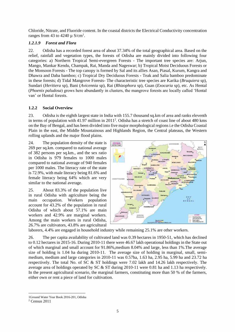
2.4 Geographic Scope of the Program ........................................................................................ 13
2.5 Government Program and Bank Financed Program (P Vs p) ............................................... 13
2.6 Key Program Implementing Agencies .................................................................................. 14
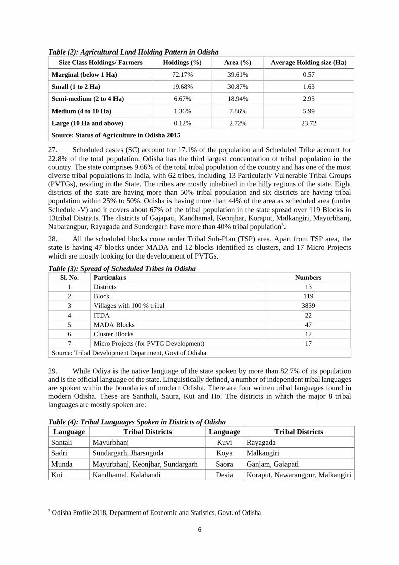
2.6.1 Implementation Arrangement in Odisha ....................................................................... 15
2.7 Borrower’s previous experience in Watershed Program ...................................................... 16
3 PROGRAM ENVIRONMENTAL AND SOCIAL EFFECTS ............................... 17 3.1.1 Environmental Effects ................................................................................................... 17
3.1.2 Social Effects ................................................................................................................ 18
3.2 Indirect and Cumulative Impact ............................................................................................ 20
3.3 Overall E&S Risks and Impacts ............................................................................................ 20
4 ASSESSMENT OF ENVIRONMENTAL AND SOCIAL MANAGEMENT
SYSTEM, CAPACITY AND PERFORMANCE ................................................................ 22 4.1 Legal, Regulatory and Institutional ....................................................................................... 22
4.2 Institutional Organization for Program Implementation ....................................................... 22
4.3 Environmental and Social management system assessment ................................................. 23
4.3.1 Core Principle-1: Program E&S Management System ................................................. 23
4.3.2 Core Principle-2: Natural Habitat and Physical and Cultural Resources ...................... 25
4.3.3 Core Principle-3: Public and Workers Safety ............................................................... 26
4.3.4 Core Principle -4: Land Acquisition and Resettlement ................................................. 27
4.3.5 Core Principle- 5: Rights and Interests of Indigenous People ...................................... 27
4.3.6 Core Principle- 6: Social Conflict ................................................................................. 29
4.4 Institutional capacity for E&S management ......................................................................... 29
4.5 Borrower’s experience in managing E&S risks .................................................................... 29
4.6 The Grievance Redress Mechanism ...................................................................................... 29
4.7 List of Excluded Activities ................................................................................................... 30
5 CONSULTATION AND DISCLOSURE ................................................................. 31

iii
5.1 Key Stakeholders .................................................................................................................. 31
5.2 Consultations ......................................................................................................................... 31
5.3 Disclosure ............................................................................................................................. 31
5.4 Summary of Multi-stakeholder consultation workshop ........................................................ 31
6 RECOMMENDATIONS AND ACTIONS ............................................................... 33 6.1 Summary of identified gaps and activities ............................................................................ 33
6.2 Inputs to the Program Implementation Support .................................................................... 35
6.2.1 Implementation and Reporting Arrangements .............................................................. 35
6.2.2 Proposed Staffing .......................................................................................................... 35
6.2.3 Training and Capacity Building .................................................................................... 36
6.3 E&S indicators and Reporting .............................................................................................. 37
6.4 Inter-Departmental Committee to address E&S Risks and Mitigation ................................. 40
ANNEXURES ......................................................................................................................... 41
Annex-1: List Of Documents Reviewed .................................................................................. 41
Annex-2: Applicable Legal And Regulatory Framework ....................................................... 42
Annex-3(A): Core Principle #1: Program E&S Management Systems .................................. 51
Annex-3(B): Core Principle #2: Natural Habitat And Physical And Cultural Resources ....... 54
Annex-3(C): Core Principle #3: Public And Workers Safety .................................................. 56
Annex-3(D): Core Principle #4: Land Acquisition And Resettlement .................................... 58
Annex-3(E): Core Principle #5: Rights And Interests Of Indigenous People ......................... 59
Annex-4: Description Of E&S Management System And Capacity Assessment ................... 62
Annex-5(A): Category Wise List Of Stakeholders .................................................................. 65
Annex-5(B): List Of Participants – Essa Stakeholder Consultation ........................................ 66
Annex-6: Typical Size And Cost Of Physical Structures Under Watershed Program ............ 70
Annex-7: Format For Collecting Environmental Baseline Data .............................................. 71
Annex-8: Screening Format For Potential Environmental And Social Issues ......................... 75
Annex-9: Measures To Address Public And Worker Safety Against The Potential Risks
Associated ................................................................................................................................ 78

iv
LIST OF ACRONYMS
AIBP Accelerated Irrigation Benefit Programme
APD Additional Project Director
CCF Chief Conservator of Forest
CEO Chief Executive Officer
CFR Community Forest Rights
DAC Department of Agriculture and Cooperation, Govt of India
DANIDA Danish International Development Agency
DAY-NRLM Deendayal Antyodaya Yojana-National Rural Livelihoods Mission
DDP Desert Development Program
DFID Department for International Development
DLRC District Level Review Committee
DoA Department of Agriculture
DAFE Department of Agriculture & Farmers’ Empowerment
DoLR Department of Land Resource, Government of India
DSC&WD Directorate of Soil Conservation and Watershed Development
DPAP Drought Prone Areas Programme
DPR Detailed Project Report
DSS Decision Support System
DWDO District Watershed Development Officer
DWDT District Watershed Development Team
E&S Environmental and Social
EC Executive Committee
FPO Farmers' Producer Organization
CGWB Central Ground Water Board
GIS Geographic Information System
GoI Government of India
GoK Government of Karnataka
GoO Government of Odisha
GP Gram Panchayat
GRM Grievance Redressal Management
GSDP Gross State Domestic product
ICRISAT International Crops Research Institute for the Semi-Arid Tropics
IFR Individual Forest Rights
IISc Indian Institute of Science
IISWC Indian Institute of Soil and Water Conservation
IWDP Integrated Wastelands Development Programme
IWMP Integrated Watershed Management Programme
KWDP Karnataka Watershed Development Program
LRI Land Resource Inventory
LWE Left-wing Extremism
MADA Modified Area Development Agency
MGNREGA Mahatma Gandhi National Rural Employment Guarantee Act
v
MGNREGS Mahatma Gandhi National Rural Employment Guarantee Scheme
MIS Management Information System
MoRD Ministry of Rural Development
NBSS & LUP National Bureau of Soil Survey and Land Use Planning
NGO Non-Government Organization
NRAA National Rainfed Area Authority
NRLM National Rural Livelihood Mission
O&M Operation and Maintenance
OFWM On Farm Water Management
PAP Program Action Plan
PDO Project Development Objective
PforR Program for Results
PIA Project Implementation Agency
PMKSY Pradhan Mantri Krishi Sinchayee Yojana
PMU Project Management Unit
PPP Public-private partnership
PPP-IHD Integrated Horticulture Development programme through Public Private Partnership
PVTG Particularly Vulnerable Tribal Group
REWARD Rejuvenating Watersheds for Agriculture Resilience through Innovative Development
SC Scheduled Caste
SDC Swiss Development Cooperation
SHG Shelf Help Group
SLNA State Level Nodal Agency
ST Scheduled Tribe
TCB Trench cum Bunding
TERI The Energy and Resource Institute
TSP Tribal Sub Plan
UG User Group
WC Watershed Committee
WC Watershed Committee
WCDC Watershed Cell and Documentation Centers
WDC Watershed Development Component
WDD Watershed Development Department, Govt of Karnataka
WDT Watershed Development Team
WRG Water Resource Group
ZP Zilla Parishad

vi
EXECUTIVE SUMMARY
The REWARD Program
The REWARD program plans to support the WDC-PMKSY scheme with the Department of Land
Resources (DoLR) within the Ministry of Rural development (MoRD) at the centre and three states over
a period of five years. The DoLR is the national focal point and implementing agency for the WDC-
PMKSY scheme and will have key activities supported by the proposed REWARD Program. Two
states, i.e., Karnataka and Odisha have agreed to participate based on their willingness to implement a
more science-based watershed program, readiness to adopt results-based financing, and their positive
track-record in implementing the current WDC-PMKSY. Karnataka has also been identified to have an
additional role as a ‘lighthouse’ state that will enable knowledge exchange and provide capacity
building support to other states because of its experience in implementing science-based watershed
planning and monitoring at a fairly large scale through the recently concluded Bank supported KWDP
II project (also referred to as Sujala III). The Program will also support selected investments at the
national level focused on strengthening capacities and systems in the DoLR.
The Project Development Objective (PDO) of the Program is to “Strengthen capacities of national and
state institutions to adopt improved watershed management for increasing farmers” resilience and
support value chains in selected watersheds of participating states. The PDO indicators include (a)
Watershed Committees and Gram Panchayats demonstrate satisfactory watershed management as
measured through a performance rating system; (b) Land area treated with science-based watershed
management technologies; (c) Adoption of resilient agriculture technologies and practices by farmers;
(d) Increase in climate-adjusted soil moisture in targeted watershed areas; and (e) Direct Program
beneficiaries (number, disaggregated by gender and social group).
The Program focuses on two key result areas which have been agreed with the Government and through
which the Bank’s support is likely to make a significant impact. These result areas are inter-linked and
mutually reinforcing. The result areas are:
Result Area 1: Strengthened Institutions and Supportive Policy for Watershed Development
Result Area 2: Science-based Watershed Development and Enhanced Livelihoods
The Results Area-1 focuses on strengthening the institutional capacity and policy environment for
science-based, participatory watershed development in the participating states. The key results under
this Results Area includes (a) Strengthening community institutions and local government bodies
engaged in watershed management; (b) Activities enhancing women’s representation in decision-
making roles and empowerment; (c) Enhancing institutional capacity for watershed management; (d)
Establishing a national centre of excellence on watershed management; (e) Incentivizing the
development and dissemination of supportive policies on watershed development; and (f) Strengthening
monitoring and evaluation systems at national and state levels.
The Result Area-2 focuses on Science-based watershed development and enhanced livelihoods. The
Results Area-2 will concentrate on science-based watershed development and help demonstrate more
efficient and effective planning and implementation of watershed sub-projects that contribute to
livelihood enhancement. The key sub-result areas under this includes (a) Science-based watershed
development plans being developed and implemented; (b) Incentivizing implementation of
participatory, inclusive and science-based watershed development in selected model watersheds; (c)
Empowering farmers with science-based and just-in-time agro-advisories; and (d) Incentivizing value-
chain interventions and provides livelihood support for the poorest households and women towards
livelihood enhancement and COVID-19 recovery.
REWARD Program in Odisha: The REWARD program in Odisha will be implemented in seven
rainfed districts using WDC-PMKSY scheme with IBRD contribution to the tune of USD 49 million
over the five-year period. The REWARD program in Odisha is planned to develop 17 Green field sites
to establish model watersheds on saturation. For this purpose, 152 micro watersheds have been

vii
identified in five pilot districts (i.e., Nayagarh, Dhenkanal, Koraput, Sambalpur, Deogarh) for taking
up intended interventions, covering a total geographical area of 1.15 lakh ha. Land Resources Inventory
(LRI) activities will also be taken up in 5.26 lakh ha in seven districts (including five pilot districts and
Nabrangpur and Sundargarh districts) to provide comprehensive site- specific cadastral level
information useful for appropriate Natural Resources Management (NRM) planning at farm level and
integrated development of the area.
The Environmental and Social Systems Assessment
The World Bank policy and directive on PforR financing requires an environmental and social system
assessment (ESSA) of operations financed under the PforR instrument. Accordingly, an ESSA of
operations to be financed under the Program was carried out to assess the adequacy of environmental
and social systems at the state level in context of the Program boundary. The broad scope of the ESSA
is to assess the extent to which the Program systems promote environmental and social sustainability;
avoid, minimize, or mitigate adverse impacts on natural habitats and physical cultural resources; protect
public and worker safety; manage land acquisition; consider issues related to indigenous peoples and
vulnerable groups; and avoid social conflict. Further, it identified required actions for
enhancing/strengthening the Program systems and mitigating potential environmental and social risks.
The specific objectives of the ESSA included the following: (a) identify potential environmental and
social benefits, risks, and impacts applicable to the Program interventions; (b) review the policy and
legal framework related to management of environmental and social impacts of the Program
interventions; (c) assess institutional capacity for environmental and social management systems within
the Program system; (d) assess Program system performance with respect to the core principles of the
PforR instrument and identify gaps, if any; and (e) describe actions to be taken to fill the gaps that will
be used as inputs to the PAP.
ESSA Methodology: The ESSA primarily relied on desk review of existing information and data
sources, complemented by assessment through consultations, interviews and discussions with key
stakeholders. The desk review included a comprehensive review of government policies, legal
frameworks, Program documents, national guidelines for IWMP and PMKSY and other assessments of
India’s environmental and social management systems. Given the COVID19 situation and travel
restrictions and advisories on social distancing etc., primary field assessment could not be undertaken
in conventional manner and followed World Bank guidance for ‘Public Consultations and Stakeholder
Engagement in constraint situation’. This included consultations with Department of Land Resources
(DoLR) at Government of India (GoI), and State level nodal agency (SLNA)/ Directorate of Soil
Conservation and Watershed Development (DSC&WD) in Odisha, and other stakeholders including
Agriculture Department, Horticulture Dept., and some of the technical partners across the
implementation chain. Consultation with secondary stakeholders was done in a virtual manner and
based on checklist developed and shared with DSC&WD for their written response and using that as
base for further consultation/ discussion with them. In addition, two rounds of multi-stakeholder
consultations were carried out in preparation of draft ESSA report including with primary stakeholders.
Findings of the assessment have also been used in the formulation of the Program Action Plan (PAP)
along with key measures to improve environmental and social management outcomes of the Program
and have been discussed and agreed with SLNA/DSC&WD in Odisha.
Environmental and Social Summary
Odisha topography consists of fertile coastal plains to the east bounded by Bay of Bengal. Mountainous
highlands and plateau regions occupy the centre of the state. Western and north-western portions of the
state consist of rolling uplands. The state also has some major floodplains encompassing the river
systems. Almost one-third of Odisha (37.34 percent) is covered by forests, and most are in southern and
western Odisha. Odisha has a total geographical area of about 15.57 million ha, which is divided into
20,079 micro-watersheds. Of these, 16,873 are treatable and 7,721 have been taken up so far under

viii
different schemes. A total of 9,152 micro-watersheds covering an area of about 4.7 million ha is yet to
be treated. The WDC-PMKSY has been the main source of funding for watershed development in the
state. The Odisha Mineral Bearing Area Development Corporation (OMBADC) set up by the
Government of Odisha (GoO) in 2014 also provides funds to watershed development in the mining
districts of the state. In 1977-78, the state created the Directorate of Soil Conservation, which is
responsible for watershed development.
About 83.3 percent of the population live in rural Odisha with agriculture being the main occupation.
Workers population account for 43.2 percent of the population in rural Odisha of which about 18.9
percent are agricultural labourers. During 2010-11 there were 4.7 million operational holdings in the
state out of which marginal farmers account for 75 percent holding and 44 percent of land with average
size of holding being 0.57 ha. The pattern is similar among tribal groups as about 69 percent of ST
farmers have marginal holdings with average holding size being 0.6 ha. Odisha has the third largest
concentration of tribal population in the country with 62 tribes, including 13 Particularly Vulnerable
Tribal Groups (PVTGs), mostly residing in the hilly regions of the State. The Scheduled Tribe account
for 22.8 percent of the total population. Odisha is having more than 44% of the area as scheduled area
(under Schedule -V) and it covers about 67% of the tribal population in the state spread over 119 Blocks
in 13 tribal Districts.
Expected Environment and Social Effects
Potential Benefits: The overall environmental and social impact of the watershed Program is likely to
be positive, owing to benefits such as increased ground water level, improved soil moisture and increase
in green coverage, crop productivity due to multi-cropping and increase in rural incomes subsequently
reducing poverty. Strengthen capacities of project authorities and functionaries, and both public and
private specialized institutions to implement more science-based watershed projects will be beneficial
for overall hydrological services and environmental sustainability. This will improve the quality of
surface water as well as ground water and have a significant positive effect on aquatic biodiversity and
alter the diversity index of floral and faunal characteristic feature. The key social benefit of the program
includes (1) Employment creation for both marginal and small farmers as well as for wage laborers, (2)
Increased availability of drinking water, (3) Improvements in household incomes and general economic
development, (4) Improvement in the levels of knowledge about water conservation and agriculture.
Potential Environmental and Social Risks: Potential environment risks arise from the extension of
watershed interventions to forest, wetland and other environmentally sensitive areas without initial
screening at DPR level. With increased water availability there is risk of change in cropping patter to
more water intensive high value crops which may lead to excessive withdrawal of ground water. With
excessive irrigation there could be risk of increase in salinity & sodicity. Along with more water
intensive crops, there is risk to increase use of fertilizer and pesticides which eventually could pollute
ground water and downstream surface water bodies. Also, there is risk of restricting surface flow at plot
level thereby impacting water bodies in the downstream and overall hydrology. Potential social risk
emerges from the change in planning process of ‘bottoms up’ to ‘top down’ approach using LRI data,
and hence there is risk to lack of participation by small and marginal farmers, women, and vulnerable
population including tribal and landless. With change in process of planning to ‘top down’ approach,
there is risk to inadequate planning for landless and marginals. This may lead to their further
marginalization and lack of access to program benefits. The REWARD Program’s overall
environmental and social risk rating is ‘Moderate’, given that most of the Environmental and Social
Effects of the program are small scale, localized, reversible and predictable, and can be effectively
mitigated and managed through the strengthening of the existing environmental and social management
systems of the implementing agencies.
Environment and Social Systems Assessment : The present practice followed in Odisha as per the
Common Guidelines for Watershed Development Projects encourages a multi-tier ridge to valley
sequenced approach and provides for funding works (in addition to convergence with Mahatma Gandhi
National Rural Employment Guarantee Act (MGNREGA), Afforestation Schemes, etc.) which have

ix
implications for the lower reaches of watershed in terms of runoff/water yield, soil erosion &
sedimentation, fodder, etc. Irrespective of the type of forests, the land forming integral part of the
selected watershed project area having agriculture/ wasteland and forest land use, the fringe-forest areas
and the degraded areas is part of the holistic watershed treatment plan. REWARD will introduce
scientific approaches and new ways of LRI-DSS based working into the watershed development sector
in Odisha. The LRI-DSS based system takes into account detailed, site-specific data at the cadastral
level on land resources (both physical and chemical properties), which will be collected as a part of
activities under REWARD. There is a gap related to the understanding, dissemination and application
of LRI data for science-based watershed planning because of lack of experience. Therefore, scientific
agencies with experience in LRI need to train the functionaries demystifying science and in built E&S
aspects. The risk screening at present depends on knowledge of the community and the field level
functionary. Present implementation chain is well established but at present there is no articulation of
individuals or agencies responsible for implementing the E&S activities and monitoring the same.
Hydrological data on ground water storage, silt movement, surface water flow will be collected
periodically in the model watersheds and benchmark sites. This same database can be effectively used
during mid-term and end-term monitoring and evaluations to capture larger scale goals of protecting
and conserving hydrologic services and/or managing negative downstream and groundwater impacts
which otherwise remain unaddressed. If micro-watershed programs are to effectively contribute toward
achieving higher-level objectives at the watershed, sub-basin and/or basin-levels, effective institutional
mechanisms will have to be developed for this purpose as well as to measure and monitor outcomes
and impacts. Thus, it will add value to the project through an additional benefit by capturing
environmental sustainability scientifically through LRI.
Assessment of Social Systems: The existing legislative framework is adequate to ensure social
sustainability and the interest of marginalized and vulnerable population including the SC and ST.
However, the IWMP guideline and its further replacement with new generation Watershed
Development Guideline 2020 provides the legal and regulatory framework to the program and is
adequate and quite comprehensive. It clearly articulates the principles, processes, institutional
responsibilities at different level of program implementation right from national, state, district, Block/
PIA, GP and village level for watershed planning and implementation. The WDC-PMKSY/ IWMP
guidelines promotes a detailed consultation process with community groups and farmers on each land
parcel in order to prepare the watershed plan and included consultation with SC, ST and other
marginalized groups. Also, a detail consultative process using PRA methods has been instituted
including participatory wellbeing ranking is followed during DPR preparation stage to ensure inclusion
of women, tribal, and other vulnerable groups. One of the guiding principles of the WDC-PMKSY
program is to build equity and promote gender sensitivity. The watershed institutions also have
participation from SC, ST, women, and other marginalized groups as per the guidance by the state. The
Tribes Advisory Council has been constituted in Odisha which advises Government in matters related
to tribal development and welfare. The tribal families living outside the geographical area of Intensive
Tribal Development Agency (ITDA), Micro Project, MADA and Cluster are covered under the
Dispersed Tribal Development Program (DTDP). The civil works involved in the construction of
watershed structures are small in nature such as check dams, anicuts, tanks, ponds, and trenches, and
the impacts of these civil works are localized and reversible without much effort. About 15 out of the
30 districts in Odisha including some of the project districts have been identified as Left-wing
extremism (LWE) areas. Government of Odisha also undertakes various development projects,
including livelihood programs and irrigation facilities, besides critical road networks to regain lost
ground and trust by integrating community concerns into the development plans. The activities under
the program does not exacerbate any social conflicts and in-fact aligned with the government approach
of community empowerment and regaining trust.
Key Environmental and Social Gaps identified: The key environmental and social gaps identified
are (a) LRI based watershed planning and implementation being new to Odisha, hence require building
institutional capacity for the same; (b) the LRI based watershed planning being top-down planning

x
approach compared to currently ‘bottoms up’ approach, poses gaps in detailed process guideline in
giving adequate priority to community participation and risk of compromising the community
consultative process for preparation of the DPR/ watershed plan; (c) The current system lacks in doing
systematic screening for environmental and social risks and issues including for any adverse effects on
biodiversity and cultural resource; (d) There is increased chance of interventions spreading into forest
boundary and/or common property resources in absence of mechanism to check it; (e) Lack of inter-
departmental co-ordination mechanism in dealing with forest, wetland and other environmentally
sensitive areas as part of watershed plan; (f) Lack in addressing trans-boundary impact of existing
structures, forests, upstream users and impact on downstream users; (g) Intensive agriculture with crop
growing conditions, may lead to risks of overuse of chemical fertilizers, pesticides, etc, thus polluting
groundwater; (h) In absence of proper guidance, improper management of the civil activities may lead
to worker safety issues; (i) Convergence of different schemes targeting tribal and vulnerable groups
remains a challenge; and (j) Methods and parameters of M&E system is not spelt out properly for
Environmental and social risks and impacts e.g. monitoring gender specific data as well as data on
equitable benefit sharing to SC, ST, landless and other socially disadvantaged groups.
Stakeholder Consultations and Disclosure
Stakeholder consultations were undertaken with both with primary and secondary at all levels. Given
the COVID19 situation and travel restrictions and advisories on social distancing etc., primary field
assessment could not be undertaken in conventional manner and followed World Bank guidance for
‘Public Consultations and Stakeholder Engagement in constraint situation’. This included consultations
with Directorate of Soil Conservation and Watershed Development (DSC&WD) in Odisha, and other
stakeholders including Agriculture Department, Horticulture Dept., and some of the technical partners
across the implementation chain. Consultation with secondary stakeholders was done in a virtual
manner and based on checklist developed and shared with DSC&WD for their written response and
using that as base for further consultation/ discussion with them. In addition, two rounds of multi-
stakeholder consultations were carried out in preparation of draft ESSA report including with primary
stakeholders. Draft ESSA report was also shared with DSC&WD for their feedback and suggestions.
The revised ESSA report was further presented to wide range of stakeholders for their comments and
suggestion through multi-stakeholder consultation virtually organized with secondary stakeholders
including NGOs on 12th August 2020 and with primary stakeholders including civil society partners in
four rounds covering REWARD districts on 05th February 2021. The draft final ESSA report was
prepared after incorporating comments and suggestions received from these multi-stakeholder
consultation workshops.
Disclosure: The updated draft ESSA will be disclosed in country at the SLNA/DCS&WD’s website in
Odisha and on the World Bank’s external website, prior to appraisal of the project, to serve as the basis
for discussion and receipt of feedback and comments. The final ESSA will be disclosed prior to World
Bank Board consideration of the Program.
Recommendations and Actions
The key recommendations addressing the environmental and social systems gaps identified, as well as
for enhancing environmental and social benefits includes:
1. With transition to science-based approach to watershed planning, SOP/ guideline to be prepared
and adopted for community participation, social inclusion, building community ownership, and
accountability mechanism in line with the WDC-PMKSY new watershed development guideline
for different phases of watershed planning and implementation. This should include a detailed
process guideline for undertaking the consultations with community during DPR preparation and
before approving and/or passing the DPR in Gram Sabha for further considerations.
2. All functionaries at every levels of DSC&WD including field functionaries such as PIA members,
Watershed Assistant/ Agriculture Assistant shall be trained of in demystifying science-based

xi
planning approach to farmers and undertaking environmental and social risk management activities
and social mobilization and consultation with farmers and community groups. The process of social
mobilization and field level consultations shall be supported by local NGOs not only during
preparation but for a longer-term during implementation.
3. Early screening of potential environmental and social risks and issues using screening checklist as
per Annex-9 by WDC and GP during DPR preparation and shall form as part of the DPR. WDC
and GP members to be trained by DSC&WD on conducting screening.
4. Land use and ownership should be made visible in LRI/ DSS platform to avoid any issue. Also,
displaying the environmentally sensitive areas on LRI map and data. This will help in protecting
environmentally sensitive areas and natural and cultural heritage in micro watersheds and eliminate
chance of extending project interventions to such sensitive areas. The environmental screening can
also be duly applied using following layers captured through LRI data outputs during DPR
preparation.
a. LRI system currently can display following layers with excel databases as part of LRI
outputs for DPR preparation, which are already captured in the LRI database and
includes:
i. Forest land,
ii. Area impacted with salinity (Ece = >4.0) or sodicity (ESP = >25),
iii. Waterlogged areas,
iv. Steeply sloping lands
v. Physical and cultural resources like monuments, temples, religious or socially
sacred areas
b. Another layer which is currently not being captured through LRI is of designated
wetlands and requires to be captured.
6. Inclusion of gender and socially disaggregated data in M&E system along with periodic monitoring
and reporting on E&S parameters. This should include capturing gender-disaggregated data for
watershed planning, including women in leadership positions in watershed committees and FPOs,
as well as among direct participants and beneficiaries of livelihood interventions, and reporting
towards enhancing women participation in local institutions.
7. Preparation and adoption of E&S operations guidance note for watershed sub-projects and FPO
business plans, including, a mechanism for institutionalizing DPR specific Environment and Social
Management Plans (ESMPs).
8. Strengthening institutional mechanism for E&S aspects with clear roles and responsibilities at state,
district, block and PIA level. This will include co-designating officials involved in watershed
program with environmental and social safeguard responsibilities along with providing E&S
training to them e.g., Assistant Director (NRM) and Assistant Director (Livelihood) at the district
level can be co-designated for district level E&S responsibilities.
9. DAFE to develop mechanism for effective coordination and convergence with other department
including Forest Department, ST &SC Development, Minority, and Backward Class Welfare
Department, and Rural Development and Panchayati Raj Department especially in Scheduled-V
areas.
10. Extended handholding support to be provided focusing more on building overall capacity of the
tribal and vulnerable groups including women for taking equitable benefits of the program.
11. Crop Advisories by the Government shall include the advisories on adverse impact of overuse of
insecticides and chemical fertilizers as per the Pesticide & fertilizer management plan to be prepared
by the Government.
12. Addressing macro and micro-level environmental issues such as overall hydrology which includes
water resource budget, conservation, flow, etc., in the macro watershed, change in ground water
table, change in water quality.
xii
13. DAFE will further assess the existing Grievance Redress Management (GRM) system and based
on requirements, will further strengthened it potentially by adding additional module to the farmer’s
help desk for registering, screening and redressing and monitoring grievances.
14. Establishing a scientific assessment and evaluation system, including a rigorous impact evaluation
that encompasses the application of remote sensing and GIS technologies; process monitoring, and
thematic studies for assessing change in specific parameters (such as groundwater level, sediment
load, soil organic carbon) to evaluate the effectiveness of watershed investments.
While most of the recommendations will be incorporated in the program operations manual, a higher-
level action is recommended as part of the program action plan (PAP).
Input to Program Action Plan: While most of the recommendations will be incorporated in the
program operations manual, a higher-level action is recommended as part of the program action plan
(PAP) as detailed out below. In addition, the E&S section of the Program Manual to further detail out
the plans for addressing the above recommendations along with timeline.
Action description Responsibility Timing Completion Measurement
1. Protocol/ Standard Operating
Procedure (SOP) to be prepared and
adopted by WDD detailing out
mechanism of community participation
and building ownership of the
watershed plan based on science-based
data inputs.
SLNA/
PR&RD
Department
One time activity
(within twelve
months of
program
effectiveness)
Process guideline prepared for
participation/ community
consultation covering women,
tribal, and other marginalized
groups during WS plan
preparation and before Gram
Sabha approval; and
guidance/GO issued for adopting
the same.
2. Adoption/ strengthening of capturing
gender-disaggregated data for
watershed planning and reporting
towards enhancing women participation
in local institutions.
SLNA/ WDD One time activity
(within 24
months of
program
effectiveness)
Gender disaggregated data
collection at watershed level, and
state-level reporting on (a)
representation in WCs, (b)
investments in common assets
and (c) women-led WCs.
3. Strengthening Grievance Redress
Mechanism (GRM) for registering,
screening, redressing, and monitoring of
grievances, and periodic reporting on
the same.
SLNA/
PR&RD
Department
One time activity
(within twelve
months of
program
effectiveness)
Strengthened GRM system
functional and periodic reports
being generated.
Mainstreaming of E&S Recommendations: Most of the E&S recommendation will be part of State
Specific Program Manual and some would be mainstreamed and are incorporated in Result Areas, PDO
indicators and DLRs.
Implementation Support Plan
The Implementation Support Plan (ISP) outlines the approach that the World Bank will take to support
DSC&WD in the implementation of environmental and social recommendation and actions of the
REWARD Program, including reviewing the implementation progress, providing technical support
where needed and will be delivered through multiple channels: six-monthly implementation support
missions; interim technical missions. The main thrust of the Bank’s implementation support will be
concentrated on the overall implementation quality of Environmental and social risk management for
sustainable environmental and social outcomes of the project.

1
1 ENVIRONMENT AND SOCIAL OVERVIEW
1.1 The Environmental and Social Systems Assessment (ESSA)
1.1.1 ESSA: Purpose and Objectives
This Environmental and Social Systems Assessment (ESSA) has been prepared by a World Bank ESSA
Team for the proposed Rejuvenating Watersheds for Agricultural Resilience through Innovative
Development (REWARD) program in India with two participating states, i.e., Karnataka and Odisha,
and will be supported by the World Bank’s Program for Results (PforR) financing instrument. In
accordance with the requirements of the World Bank Policy Program-for-Results (PforR) Financing
Policy, PforRs rely on country-level systems for the management of environmental and social effects.
The PforR Policy requires that the Bank conduct a comprehensive ESSA to assess the degree to which
the relevant PforR Program’s systems promote environmental and social sustainability. Additionally,
the ESSA is in place to ensure that effective measures are in place to identify, avoid, minimize, or
mitigate adverse environmental, health, safety, and social impacts. Through the ESSA process, the Bank
ESSA Team develops recommendations to enhance environmental and social management within the
Program, which are both included in the overall management action plan.
1. The main purposes of this ESSA is to: (i) identify the Program’s environmental, health, safety,
and social effects; (ii) assess the legal and policy framework for environmental and social management,
including a review of relevant legislation, rules, procedures, and institutional responsibilities that are
being used by the Program; (iii) assess the implementing institutional capacity and performance to date,
to manage potential adverse environmental and social issues; and (iv) recommend specific actions to
address gaps in the Program’s environmental and social management system, including with regard to
the policy and legal framework and implementation capacity.
2. This ESSA assesses or considers the extent to which the Program’s environmental and social
management systems are adequate for and consistent with six core environmental and social principles
(hereafter, Core Principles), as may be applicable or relevant under PforR circumstances. The Core
Principles are listed below and further defined through corresponding Key Planning Elements that are
included under each Core Principle in Section Error! Reference source not found..
(a) Core Principle 1: Environmental and Social Management: Environmental and social
management procedures and processes are designed to: (a) promote environmental and social
sustainability in Program design; (b) avoid, minimize, or mitigate against adverse impacts; and
(c) promote informed decision making related to a Program’s environmental and social effects.
(b) Core Principle 2: Natural Habitats and Physical Cultural Resources: Environmental and
social management procedures and processes are designed to avoid, minimize, and mitigate
any adverse effects (on natural habitats and physical and cultural resources) resulting from the
Program.
(c) Core Principle 3: Public and Worker Safety: Program procedures ensure adequate measures
to protect public and worker safety against the potential risks associated with: (a) construction
and/or operations of facilities or other operational practices developed or promoted under the
Program; and (b) exposure to toxic chemicals, hazardous wastes, and otherwise dangerous
materials.
(d) Core Principle 4: Land Acquisition: Land acquisition and loss of access to natural resources
are managed in a way that avoids or minimizes displacement, and affected people are assisted
in improving, or at least restoring, their livelihoods and living standards.
(e) Core Principle 5: Indigenous Peoples and Vulnerable Groups: Due consideration is given
to cultural appropriateness of, and equitable access to, Program benefits, giving special
attention to the rights and interests of indigenous peoples and to the needs or concerns of
vulnerable groups.

2
(f) Core Principle 6: Social Conflict: Avoid exacerbating social conflict, especially in fragile
states, post-conflict areas, or areas subject to territorial disputes.
3. An additional purpose of this ESSA is to inform decision making by the relevant authorities in
the borrower country and to aid the Bank’s internal review and decision process associated with the
proposed Rejuvenating Watersheds for Agricultural Resilience through Innovative Development
(REWARD) program. The findings, conclusions and opinions expressed in this document are those of
the World Bank and the recommended actions that flow from this analysis will be discussed and agreed
with counterparts in DoLR (GoI) and the borrowing states and will become legally binding agreements
under the conditions of the new loan.
1.1.2 ESSA Methodology
4. The current ESSA report is based on desk review of existing information and data sources.
Given the COVID19 situation, primary field assessment and consultations is yet to be conducted to
supplement the assessment to captures opinions, anecdotal evidence, functional knowledge, and
concerns of various stakeholders. Based on ground level situation of COVID19 in near future, the field
visit, and stakeholder consultations will be undertaken to further improve upon the current draft. The
desk review included a comprehensive review of government policies, legal frameworks, Program
documents, national guidelines for IWMP and PMKSY and other assessments of India’s environmental
and social management systems.
5. Given the COVID19 situation and travel restrictions and advisories on social distancing etc.,
primary field assessment could not be undertaken in conventional manner and followed World Bank
guidance for ‘Public Consultations and Stakeholder Engagement in constraint situation’. This included
consultations with Department of Land Resources (DoLR) at Government of India (GoI), and State
level nodal agency (SLNA)/ Directorate of Soil Conservation and Watershed Development
(DSC&WD) in Odisha, and other stakeholders including Agriculture Department, Horticulture Dept.,
and some of the technical partners across the implementation chain. Consultation with secondary
stakeholders was done in a virtual manner and based on checklist developed and shared with DSC&WD
for their written response and using that as base for further consultation/ discussion with them.
6. In addition, two rounds of multi-stakeholder consultations were carried out in preparation of
draft ESSA report including with primary stakeholders. Findings of the assessment have also been used
in the formulation of the Program Action Plan (PAP) along with key measures to improve
environmental and social management outcomes of the Program and have been discussed and agreed
with SLNA/DSC&WD in Odisha.
1.2 Environment and Social Overview
1.2.1 Environment Overview
1.2.1.1 Administrative
7. Odisha extends over an area of 155,707 sqkm and is split into 30 districts. Mayurbhanj is the
largest district while Jagatsinghpur is the smallest. The state is further divided into 314 revenue blocks.
The largest district has the highest number of blocks with 26 blocks, while Deogarh and Boudh district
have lowest with three blocks.
1.2.1.2 Agro-climatic zones
8. The state has also been divided into ten agro-climatic zones under National Agricultural
Research Project (NARP), ICAR. The zones comprise of two plateau zones, two coastal zones, three
Ghat zones and three Table Land zones. Generally, each NARP zone covers 2 to 4 districts and is spread
over an area of 40,000 to 50,000sq.km. Agro-climatic zones assist in finding out land suitability,
potential production and environmental impact.

3
1.2.1.3 Climatology
9. Orissa enjoys a typical tropical climate, mainly because of its proximity to the sea. Here,
summers are very hot and monsoons very wet. Orissa 3experiences three main seasons, namely summer,
winter and monsoons.
10. The state gets maximum rainfall, nearly 80% of the annual, from the South- west (SW)
monsoon during June to September (IMD, 2000). The long-term average rainfall of Orissa (1901-1996)
is 1422 mm with standard deviation (SD) of 204.1 mm and coefficient of variation (CV) of 14.3%.
11. December and January are the coldest months, while May is the hottest month. The mean
monthly maximum temperature (1901-1996) of May is 37.10C with standard deviation of 3.64 and
coefficient of variation of 9.94%. The mean monthly temperature of December is 13.8°C with SD of
4.6 and CV 33.3%. Among the districts, the annual mean maximum temperature varies from 28.1 to
34.9°C and the mean minimum temperature varies from 16.7 to 23.2°C.
12. Mean relative humidity (RH) is maximum (84%) during July to August, while it is minimum
during April to May (63%). The annual evaporation rate in the state is 1598 mm. It is the highest during
May (241 mm) and the lowest during
December (87 mm). The mean annual wind
speed in the state is 7.6 km per hour. The
average sunshine per day is 7.3 hour. It is
minimum of 3.5 hour per day in July and
August. From October sunshine duration
increases and reaches 9.4 hour per day
during February to March.
1.2.1.4 Physiography
13. Odisha can be broadly divided into
five major physiographic regions. They are
the coastal plains of the east, the central
plateaus, the central mountainous and
highlands region, the western rolling uplands
and the main flood plains. It is a coastal state and has a coastline 450km long. The western and northern
portions of the state are part of the Chota Nagpur plateau. The coasts consist of fertile alluvial plains
and the valleys of major rivers such as Mahanadi, Brahmani and Baitarani, which drains to the Bay of
Bengal.
1.2.1.5 Geology
14. The geology of Odisha is complex and varied. The state is home to some of the oldest rock
formations on the planet. The second oldest rocks, 4.2 billion years old, were found
in Champua, Kendujhar. Odisha is part of two cratonic blocks called North Orissa Craton (NOC) and
the West Orissa Craton (WOC). There is a third block called the Eastern Ghats Granulite Belt (EGB).
It was considered a ‘mobile belt’ during the middle Proterozoic Era. These formations are separated
from each other by deep-seated regional fault boundaries. The fault boundaries are called as the north
Orissa boundary fault (NOBF) (running along Mahanadi Valley this is also called the 'Mahanadi Rift')
and the west Odisha boundary fault (WOBF).
1.2.1.6 Soil
15. Odisha’s soil has lost its productive potential, over the years, due to imbalanced fertilizer use,
over-exploitation from mining and poor replenishment of nutrients. Texture-wise, 54.8 per cent soils in
the state are loamy, 43.3 per cent clayey and 0.3 per cent sandy. Twenty per cent soils have high water
holding capacity, 46.2 per cent medium and 32.4 percent low.
16. About 60% soil in the state has medium status OC and 40% low. Soils in the state are generally
low in total N. The P status ranges from low (27 %) to medium (73 %). The K status ranges from

4
medium (86 %) to high (7 %). The deficiencies of S, B and Zn have a mean value of 28%, 44% and
19% respectively. Sporadic deficiency of Fe and Mn occurs in intensively cultivated areas.
17. A few problem soils in Odisha are as follows:
• Acid soils - Nutritionally acid soils are deficient in N, P, Ca, Mg, S, B, Zn, Mo and Si.
Biologically acid soils are inactive,
• Saline soils – decline in productivity ranging from 10 – 50%,
• Water logged soils – water logging due to poor drainage systems is a major problem in the state,
• Spoil soils – a large number of mining operations in Odisha are open cast; mine spoils from the
mining sites are dumped degrading the soil and adjoining areas,
• Shifting sand dunes – infertile soil which shifts due to the prevalence of strong coastal winds,
• Strip lands – land along public roads, railways, canal areas are not cultivated and remain fallow;
they account for 1.15 lakh ha in the state.
1.2.1.7 Ground Water Condition
18. In general, the state recorded water level in 2-10mbgl range in all the districts during April,
2016. Some wells in the hilly areas recorded water level in the range of 10-20mbgl. During August,
2016, water level was found in the range of 0-2mbgl in coastal stretch and in parts of the hilly terrain,
whereas 2-5 mbgl in the coastal and hard rock terrain. During November, 2016, the water level was
found to be same as August, 2016.During January, 2017, water level was in the range of 2-5mbgl in the
coastal stretch / parts of hilly terrain, whereas 0-2m in coastal and command areas.
19. During April 2016, the water level (meter below ground level) in the state varies from minimum
of 0.2 mbgl in Bargarh district to a maximum of 18.8 mbgl in Angul district and water levels mostly
range from 2 to 10 mbgl. Some wells in the hilly districts recorded water level in 10-20 m range. During
August 2016, the depth to water level ranges from 0.05 to 11.4 mbgl and in majority (53%) of National
Hydrograph Stations wells level was in the range of 0-2 m below ground level and 38.4% of wells in 2-
5 m below ground level. In general, as it should be, a rise in water level is observed throughout the state
during January 2017 with respect to April 2016 and majority of wells recorded 0-4 m rise because of
recharge of aquifer due to monsoon rainfall.
20. Network of National Hydrograph Stations (CGWB) monitored in the REWAD districts in
2016-17 is indicated below.
Table (1): Network of Hydrograph Stations in the REWTAD Districts
Sl No Districts April, 2016 Aug, 2016 Nov, 2016 Jan, 2017
1 Sambalpur 87 87 87 90
2 Dhenkanal 46 46 46 46
3 Nayagarh 55 55 55 55
4 Deogarh 12 12 12 12
5 Koraput 64 64 64 64
6 Nowarangpur 27 27 27 27
7 Sundargarh 99 99 99 99
1.2.1.8 Ground Water Quality
21. The shallow aquifers of inland zone of the state are mostly fresh and dominated by Ca-Mg-
HCO3 and mixed types of water. In the coastal plain where most of the wells are located in alluvium,
the water is relatively saline. The shallow aquifers of the coastal plain are of Na-HCO3 type with some
isolated patches of NaCl and Ca-Mg-HCO3 types, which may be due to Base Exchange process and
also due to the vicinity of the sea. These aquifers, at places, are of high Electrical Conductivity and high
5
Chloride, Nitrate, and Fluoride content. In the coastal districts the Electrical Conductivity concentration
ranges from 43 to 4240 µ S/cm1.
1.2.1.9 Forest and Flora
22. Odisha has a recorded forest area of about 37.34% of the total geographical area. Based on the
relief, rainfall and vegetation types, the forests of Odisha are mainly divided into following four
categories: a) Northern Tropical Semi-evergreen Forests - The important tree species are: Arjun,
Mango, Mankar Kendu, Champak, Rai, Manda and Nageswar; b) Tropical Moist Deciduous Forests or
the Monsoon Forests - The top canopy is formed by Sal and its allies Asan, Piasal, Kurum, Kangra and
Dhawra and Daba bamboo; c) Tropical Dry Deciduous Forests - Teak and Salia bamboo predominate
in these forests; d) Tidal Mangrove Forests- The characteristic tree species are Karika (Bruquiera sp),
Sundari (Heritiera sp), Bani (Avicennia sp), Rai (Rhizophora sp), Guan (Exocaria sp), etc. As Hental
(Phoenix paludosa) grows here abundantly in clusters, the mangrove forests are locally called ‘Hental
van’ or Hental forests.
1.2.2 Social Overview
23. Odisha is the eighth largest state in India with 155.7 thousand sq.km of area and ranks eleventh
in terms of population with 41.97 million in 20112. Odisha has a stretch of coast line of about 480 kms
on the Bay of Bengal, and has been divided into five major morphological regions i.e the Odisha Coastal
Plain in the east, the Middle Mountainous and Highlands Region, the Central plateaus, the Western
rolling uplands and the major flood plains.
24. The population density of the state is
269 per sq.km. compared to national average
of 382 persons per sq.km., and the sex ratio
in Odisha is 979 females to 1000 males
compared to national average of 940 females
per 1000 males. The literacy rate of the state
is 72.9%, with male literacy being 81.6% and
female literacy being 64% which are very
similar to the national average.
25. About 83.3% of the population live
in rural Odisha with agriculture being the
main occupation. Workers population
account for 43.2% of the population in rural
Odisha of which about 57.1% are main
workers and 42.9% are marginal workers.
Among the main workers in rural Odisha,
26.7% are cultivators, 43.8% are agricultural
laborers, 4.4% are engaged in household industry while remaining 25.1% are other workers.
26. The per capita availability of cultivated land was 0.39 hectares in 1950-51, which has declined
to 0.12 hectares in 2015-16. During 2010-11 there were 46.67 lakh operational holdings in the State out
of which marginal and small account for 91.86%,medium 8.04% and large, less than 1%.The average
size of holding is 1.04 ha during 2010-11. The average size of holding in marginal, small, semi-
medium, medium and large categories in 2010-11 was 0.57ha, 1.63 ha, 2.95 ha, 5.99 ha and 23.72 ha
respectively. The total No. of SC & ST holdings were 7.02 lakh and 14.26 lakh respectively. The
average area of holdings operated by SC & ST during 2010-11 were 0.81 ha and 1.13 ha respectively.
In the present agricultural scenario, the marginal farmers, constituting more than 50 % of the farmers,
either own or rent a piece of land for cultivation.
1Ground Water Year Book 2016-201, Odisha 2 Census 2011
6
Table (2): Agricultural Land Holding Pattern in Odisha
Size Class Holdings/ Farmers Holdings (%) Area (%) Average Holding size (Ha)
Marginal (below 1 Ha) 72.17% 39.61% 0.57
Small (1 to 2 Ha) 19.68% 30.87% 1.63
Semi-medium (2 to 4 Ha) 6.67% 18.94% 2.95
Medium (4 to 10 Ha) 1.36% 7.86% 5.99
Large (10 Ha and above) 0.12% 2.72% 23.72
Source: Status of Agriculture in Odisha 2015
27. Scheduled castes (SC) account for 17.1% of the population and Scheduled Tribe account for
22.8% of the total population. Odisha has the third largest concentration of tribal population in the
country. The state comprises 9.66% of the total tribal population of the country and has one of the most
diverse tribal populations in India, with 62 tribes, including 13 Particularly Vulnerable Tribal Groups
(PVTGs), residing in the State. The tribes are mostly inhabited in the hilly regions of the state. Eight
districts of the state are having more than 50% tribal population and six districts are having tribal
population within 25% to 50%. Odisha is having more than 44% of the area as scheduled area (under
Schedule -V) and it covers about 67% of the tribal population in the state spread over 119 Blocks in
13tribal Districts. The districts of Gajapati, Kandhamal, Keonjhar, Koraput, Malkangiri, Mayurbhanj,
Nabarangpur, Rayagada and Sundergarh have more than 40% tribal population3.
28. All the scheduled blocks come under Tribal Sub-Plan (TSP) area. Apart from TSP area, the
state is having 47 blocks under MADA and 12 blocks identified as clusters, and 17 Micro Projects
which are mostly looking for the development of PVTGs.
Table (3): Spread of Scheduled Tribes in Odisha
Sl. No. Particulars Numbers
1 Districts 13
2 Block 119
3 Villages with 100 % tribal 3839
4 ITDA 22
5 MADA Blocks 47
6 Cluster Blocks 12
7 Micro Projects (for PVTG Development) 17
Source: Tribal Development Department, Govt of Odisha
29. While Odiya is the native language of the state spoken by more than 82.7% of its population
and is the official language of the state. Linguistically defined, a number of independent tribal languages
are spoken within the boundaries of modern Odisha. There are four written tribal languages found in
modern Odisha. These are Santhali, Saura, Kui and Ho. The districts in which the major 8 tribal
languages are mostly spoken are:
Table (4): Tribal Languages Spoken in Districts of Odisha
Language Tribal Districts Language Tribal Districts
Santali Mayurbhanj Kuvi Rayagada
Sadri Sundargarh, Jharsuguda Koya Malkangiri
Munda Mayurbhanj, Keonjhar, Sundargarh Saora Ganjam, Gajapati
Kui Kandhamal, Kalahandi Desia Koraput, Nawarangpur, Malkangiri
3 Odisha Profile 2018, Department of Economic and Statistics, Govt. of Odisha

7
2 PROGRAM DESCRIPTION
2.1 Strategic and Institutional Context
30. Rainfed agriculture represents a major share of the agricultural sector and is facing significant
challenges. Of the 127 agro-climatic zones in India, 73 are rainfed, with 13 states accounting for about
three-quarters of the total rainfed area. Generally, these rainfed areas receive less than 750 mm of
rainfall annually and have less than 30 percent of cropland under irrigation (from both surface and
ground water). From the total area under agricultural in India (141 million hectares), approximately 55
percent of the gross cropped area is under rainfed cultivation, mostly in arid and semi-arid areas.
31. Integrated watershed management provides a constructive framework to deal with the
challenges facing rainfed farmers by addressing issues relating to land and water resources in an
integrated manner. It offers a significant improvement in sustained water resource development through
recharging local aquifers and improving downstream water flows; increasing more effective water
demand practices; decreasing soil erosion and loss of fertility; increasing agricultural productivity and
income; helping farmers adapt to climate change; and improving rural livelihoods. Watershed
development is also seen as a key measure by the Government to achieve SDG 15.3.
32. Watershed management programs in India have evolved over time in terms of their approach,
strategy and operational scale. In the late 1970s watershed management programs were mainly top-
down engineering-focused soil and water conservation infrastructure development to protect large
downstream water bodies (especially dams) from silting up. From the late 1980s, programs began
focusing on soil and water issues and productivity in resource-poor, poverty-stricken upstream areas.
From the late 1990s, a new approach based on participatory watershed planning, implementation and
management was pioneered in several states including Odisha (supported by Department for
International Development (DFID), Danish International Development Agency (DANIDA)) and
Karnataka (supported by DFID, DANIDA, World Bank). In 2009, the Integrated Watershed
Management Programme (IWMP) was launched, which marked the consolidation of various watershed
development schemes under an integrated program. In 2015-16, the IWMP became a component of the
GoI’s flagship program on extending irrigation coverage and improving water use efficiency – the
Pradhan Mantri Krishi Sinchayee Yojana (PMKSY). Recently, watershed programs, such as the
Karnataka Watershed Development Project (KWDP)-II (known locally as ‘Sujala III’) financed by the
Bank, began emphasizing improved biophysical and socio-economic site data, more science-based
watershed planning, and value-chain development through investments in farmer producer
organizations (FPOs) and market linkages. The operational scale of watershed development has also
shifted over time from larger treatment areas to smaller micro-watersheds and then to a meso-scale
focused on clusters of micro-watersheds covering contiguous areas4.
33. A robust institutional architecture for watershed development exists in the country. The
Department of Land Resources (DoLR) of the Ministry of Rural Development (MoRD), GoI is the key
national agency responsible for watershed development. The National Rainfed Areas Authority
(NRAA) of the Ministry of Agriculture and Farmers’ Welfare (MoAFW) provides technical and policy
support to the DoLR on watershed development. State Level Nodal Agencies (SLNAs)5, housed in
various agencies6, are responsible for delivering national watershed programs, including watershed
planning, resource mobilization, monitoring, capacity building, and coordination through their district
and block level structures. To facilitate meaningful engagement of the community in planning,
implementation, and monitoring of watershed development, community level institutions and local
4 Over time, watershed programs typically covered areas of 50,000 ha; from early 1990s to 2000s the programs
moved to treating micro-watersheds of 500 ha; and from 2008 onwards the watershed programs focused on
clusters of micro-watersheds covering contiguous areas of around 5,000 ha, emphasizing on a saturation approach
of treating a high percentage of the site. 5 also referred to as State Watershed Departments (SWDs) in this document. 6 Depending on the state, this could be the Department of Agriculture, Panchayat Raj Department, Forest
Department, or in some cases a separate Watershed Development Department.

8
government bodies are supported. These include Watershed Development Committees (WDCs), farmer
or water user groups, Self-Help Groups (SHGs), and the Gram Panchayats (GPs).
The WDC-PMKSY is a key source of funds for watershed management in the country. The DoLR
provides national guidelines and funds in 60:40 cost sharing ratio to states through national watershed
schemes/ WDC-PMKSY for execution at the sub-project level7. DoLR aims to bring at least one-third
of untreated land under watershed development. While these programs have treated significant land
areas to date with basic soil and water conservation, the broader impacts have been below expectations
in terms of: incorporating hydrology, water management, and climate resiliency into plans and
investments; supporting farmers to transition to climate resilient farming practices, more value addition
and market access for increased productivity and incomes; and strengthening rural livelihood
development to improve overall equity and opportunities for women.
2.2 Bank Financed PforR Program Scope and Boundaries
34. The REWARD PforR (Program for Results) will support the next phase of the WDC-PMKSY
program. The proposed USD 115 million allocation to the REWARD PforR will be a sub-set of the new
WDC-PMKSY program at both the national level and in the two project states. Through the 2020-21
fiscal year in the current WDC-PMKSY and the follow-on program, the DoLR plans to undertake
watershed management on 4.95 million ha during 2021-2026. The USD 1.14 billion allocation
represents only DoLR’s share. The cost-sharing with states is expected to continue at 60:40, inferring
that the total cost of the new program will be USD 1.9 billion. While the WDC-PMKSY program is
implemented across all states (except for the Union Territory of Goa), the REWARD Program will be
initially supporting the watershed program in two selected states – Karnataka and Odisha, as well as at
the national level over a five-year period. At the national level, the REWARD Program scope covers
management, monitoring, communication and knowledge sharing functions of the DoLR. At the state
level, the REWARD Program will be contiguous in scope to the WDC-PMKSY, and support
implementation of key science-based activities and demonstration sites, and in so doing, aim to
influence the broader WDC-PMKSY in these two states.
35. The Program is planned to be implemented in selected states of India including Odisha based
on them meeting specific qualifying and readiness criteria including their willingness to implement a
science-based watershed program. The state of Karnataka has been identified to have an additional role
as a ‘lighthouse’ state that will enable knowledge exchange and provide capacity building support to
other states because of its experience in implementing science-based watershed planning and
monitoring at a fairly large scale through the recently concluded Bank supported KWDP II project (also
referred to as Sujala III). The Program will also support selected investments at the national level
focused on strengthening capacities and systems in the DoLR.
2.3 Program Development Objective
36. The Project Development Objective (PDO) of the Program is to “Strengthen capacities of
national and state institutions to adopt improved watershed management for increasing farmers’
resilience and support value chains in selected watersheds of participating states”. The PDO indicators
include:
a. Watershed Committees and Gram Panchayats demonstrate satisfactory watershed management
as measured through a performance rating system.
b. Land area treated with science-based watershed management technologies.
c. Adoption of resilient agriculture technologies and practices by farmers.
d. Increase in climate-adjusted soil moisture in targeted watershed areas; and
e. Direct Program beneficiaries (number, disaggregated by gender and social group).
7 The DoLR and SWDs use the term ‘project’ to refer to the watershed development activities covered by a single
‘Detailed Project Report’ and typically covering a sub-watershed or a micro-watershed. However, this document
uses the term ‘sub-project’ to refer to the same, to avoid confusion with other national and state level projects.
9
37. The primary beneficiaries of the REWARD Program are communities in rainfed areas that rely
on sustainable land and water resources for livelihoods and ecosystem services. The sustainable
development of watersheds based on better scientific inputs and technical capacities will lead to more
effective conservation of soil, improved surface and ground water availability and efficiency of use,
and enhanced agricultural productivity and profitability, thereby generating sustainable improvement
in incomes. It will have positive impacts on women, small and marginal farmers, and agricultural
laborers. The efforts to ensure social inclusion in watershed planning and management will enhance the
benefits that accrue to the most vulnerable.
38. REWARD Results Areas Under Results Area 1, REWARD program will,
a. Strengthen the institutional capacity and policy environment for science-based, participatory
watershed development in the participating states through: (i) development of detailed
guidelines for WCs and GPs8 for each phase of watershed development (preparatory phase,
works phase, consolidation and O&M phase); (ii) development and delivery of training modules
on inclusive participation (such as participatory planning) and governance systems (such as
standard record maintenance) for WCs, GPs and other relevant users/common interest groups,
with a special focus on the women representatives in these bodies; (iii) incentivizing
development and roll-out of a performance assessment tool and incentive system for WCs and
GPs for effective planning, implementation and sustainable watershed management;9 and (iv)
capturing of data on performance of WCs and GPs on the Performance Assessment Tool,
through the state Management Information Systems (MIS).
b. Support the following activities on women’s representation in decision-making roles and
empowerment: (i) systemic engagement of women as decision-makers in watershed
committees, watershed development teams and water user groups and other common interest
groups; (ii) integrating clearly defined roles for women in each of the four phases of watershed
development; (iii) targeted leadership and technical training for women leaders on effective
watershed management practices; (iv) structured consultations with women’s groups as part of
the baseline survey to be included in DPRs preparation/implementation and O&M phases; and
(v) state-level MIS systems to adopt gender-disaggregated data collection in watershed
planning.10
c. Support for Institution Capacity building for WDC-PMKSY will be through: (i) development
of an improved human resources policy for attracting and retaining adequate numbers of
professionals, including better targeting of women professionals, with necessary skill sets at
various levels; (ii) placement of critical human resources at the state, district, block/sub-block
levels, especially to fill gaps in the areas of hydrology, agriculture, institution building, social
inclusion and gender; (iii) design and delivery of core training modules on operationalizing
women’s consistent representation and decision-making in watershed committees, inclusion
and social sustainability measures in watershed development at the state, district, block/sub-
block levels; and (iv) equipping and training staff in IT and communication systems to improve
planning and management.
d. Establish a national center of excellence on watershed management: Karnataka has rich
expertise in implementation of science-based watershed management including the application
8 The guidelines will include provisions for mitigating risk of elite capture and exclusion of vulnerable groups
including women. These guidelines would be complementary to the new national watershed guidelines, providing
more detailed local guidance to WCs and GPS on their roles and responsibilities with watershed development
programs. 9 The Performance Assessment Tool will have indicators and a scoring system. The indicators could include:
handing over of treated watersheds to WCs/GPs completed; percent of Watershed Development Fund mobilized
by the WCs/GPs; asset register maintained by WCs/GPs; training of WC/GP members on O&M of watersheds
completed; multi-year O&M plan developed by WCs/GPs. 10 Socio-economic/gender disaggregation in watershed committees, watershed user groups, beneficiary
investments in common assets.

10
of LRI, hydrogeology, DSS to planning; and the use of remote sensing and Geographic
Information Systems (GIS) for planning and monitoring. It will be supported under the
REWARD Program to becomes the ‘lighthouse’ state for science-based watershed
management. India will benefit from the creation of a specialized institution that focuses on
dissemination of knowledge from Karnataka to all states, and whose existence outlasts the
REWARD Program. Towards this, the REWARD Program will incentivize the: (i)
establishment of a national center of excellence on watershed management in Karnataka,
drawing on the expertise and experience of key technical partners involved in KWDP-II; (ii)
development of the curriculum framework, teaching–learning modules and materials (such as
training manuals, learner resources) on science based watershed management; (iii) roll out of
trainings for national and state functionaries of participating states as well as other states; (iv)
action research studies and demonstration pilots on thematic areas relevant to science-based
watershed management (such as soil carbon, monitoring of ground and surface water
resources); and (v) development and management of a knowledge portal on science-based
watershed management.
e. Incentivize the development and dissemination of supportive policies at the national and state
levels. At the national level, the Program will generate data and lessons learned to support the
development of new technical standards and operational protocols for science-based watershed
development. These standards will be developed by the DoLR, based on implementation
experience in the participating states, and will be disseminated to other states. At the state level,
the Program will support the development of a strong O&M policy, and the piloting of science-
based fertilizer demand and supply policies.11
f. Strengthen monitoring and evaluation systems at national and state levels. While M&E systems
of watershed programs have been largely limited to a MIS in the past, the current emphasis is
to move beyond mainly tracking inputs and outputs. The REWARD Program will support a
transition to a state-of-the-art monitoring, evaluation, learning, and knowledge sharing system
in two ways. First, by strengthening MIS on watershed management through the development
and deployment of a GIS-enabled MIS platform that: focuses on tracking activities, outputs and
outcomes; integrates tracking of process efficiency and quality (such as time taken for each
phase in the watershed sub-project cycle); provides for real-time updating and analytics; and
strengthens gender-disaggregated data systems to adequately capture the priorities of women.
Second, the REWARD Program will establish a scientific assessment and evaluation system,
including a rigorous impact evaluation that encompasses the application of remote sensing and
GIS technologies, process monitoring, and thematic studies for assessing change in specific
parameters (such as groundwater level, sediment load, soil organic carbon) to evaluate the
effectiveness of watershed investments.
39. Results Area 2 will concentrate on science-based watershed development and help
demonstrate more efficient and effective planning and implementation of watershed sub-projects that
contribute to livelihood enhancement. The emphasis on livelihoods is considered critical in the context
of COVID-19, as it will enable quicker local/community recovery and build longer-term resilience. The
REWARD program under this Result Area will,
a. Support science-based watershed development planning and implementation. Site-specific
information on the status and variability in soil, hydrology, topography, land use, and objective
decision-making based on this information, is a prerequisite for scientific planning of watershed
development. However, due to lack of such scientific information and the capacity to use it,
watershed treatment plans are often based on a general assessment. To address this, the
REWARD Program will incentivize: (i) the development of partnerships between SWDs and
scientific and technical institutions through formal arrangements such as contracts and
11 The pilot will involve: Training of RSK staff on farmer counseling for influencing the farmer’s fertilizer
purchase decisions (to align with the information on the LRI card); Tracking data on fertilizer purchases made by
LRI farmers from RSKs for monitoring and impact evaluation; Aligning fertilizer distribution to the selected
RSKs on the basis of the LRI information on soil fertility status.
11
memoranda of understanding (MoUs) in key areas;12 (ii) development of LRI13 and hydrology14
databases on the basis of field studies and remote sensing data; (iii) development of DSS tools
covering soil and water conservation planning, crop planning, land capability grouping, nutrient
management, run-off, farm pond and check dam planning, crop water requirements, soil
moisture and water balance, water budgeting, among others; (iv) development of a digital
library and portal for storage and dissemination of the LRI and hydrology databases and DSS.
The digital portal will also link up with other relevant available data sets such as on weather
conditions and forecasts, agri-market prices; and (v) development of detailed project reports
(DPRs15) for selected model watersheds based on scientific information and community
participation.16 Activities (i) through (iv) will be implemented across about 1.7 million ha,
while activity (v) will target around 200,000 ha, across both the states.
b. Support transparency, equity, gender and community empowerment in watershed development,
the REWARD Program will incentivize implementation of participatory, inclusive, and
science-based watershed development in selected model watersheds. The model watersheds are
expected to function as sites for demonstration of good practices that can be replicated in other
watersheds both in the participating states and in other states. The implementation of the model
watershed will be based on the science-based watershed DPRs and will include interventions
on community engagement,17 engineering works;18 agriculture, horticulture and forestry
interventions;19 and livelihood support activities. These interventions are expected to improve
climate resilience through improved soil moisture, enhanced water storage based on
hydrological conditions, more efficient irrigation, more appropriate crop selection and
management, increased tree cover, etc. The creation and management of a local watershed
development fund for sustainability of the created assets and preparation of project completion
reports will be emphasized. The selection of the model watersheds will be based on criteria
including drought vulnerability, extent of rainfed area, groundwater status, socio-economic
status, value chain opportunities, capacity of district watershed teams, performance on ongoing
watershed sub-projects, availability of LRI and hydrology data from earlier assessments (in
Karnataka), and exclusion of forest areas, urban areas, command areas.
c. Farmers empowered with science-based and just-in-time agro-advisories. A key element of
building climate resilience in rainfed areas is empowering farmers with timely information on
12 While the areas of partnership will vary from state to state, it is expected that all states will establish partnerships
on the following, at a minimum: remote sensing, soil studies, hydrology, agriculture. 13 Data on bio-physical, socio-economic and hydrological characteristics of smaller land parcels in a micro-
watershed (500 ha) are systematically collected to make a LRI atlas for that micro-watershed. The LRI along with
Hydrology database and DSS help to produce a watershed plan for a sub-watershed (5000 ha). The LRI atlases
also serve the purpose of providing data for advisories to farmers on crop selection, crop water management and
nutrient management. In addition, several Government schemes (e.g., 30 identified schemes in Karnataka) are
expected to benefit from the data sets and tools generated. 14 Possibility of leveraging data available on the National Water Resources Information System (WRIS) will also
be explored. 15 The DPR is the detailed plan document of the proposed watershed sub-project. It is based on technical inputs
as well as participatory community planning. It includes details on: basic information on the watershed, user
groups, problem typology, management plan with proposed interventions, institutional mechanisms, capacity
building plan, expected outcomes, phasing and budgeting, etc., supported by relevant maps. The management
plan includes Soil and Water Conservation Plan, Productivity Improvement Plan for major agriculture and
horticulture crops, Crop Plans, etc. 16 Includes approval by the Gram Sabha, which is the General Body of the Gram Panchayat (local government). 17 Including: entry point activities, institution and capacity building activities such as formation and training of
Watershed Committee, participatory planning of watershed investments, approval of DPR by Gram Sabha,
participatory monitoring of watershed works, creation and management of Watershed Development Fund,
preparation of Project Completion Report, etc. 18 Including, as relevant: ridge area treatment, drainage line treatment, soil and moisture conservation, rainwater
harvesting, etc. 19 Including, as relevant: on-farm soil moisture conservation and water harvesting practices, nursery raising,
afforestation, horticulture, pasture development, etc.

12
land resources, soil status, weather events, etc., along with recommendations on relevant crop
selection and management practices (such as fertilizer selection and scheduling, irrigation
management). The REWARD Program emphasizes the role of agro-advisories in supporting
climate change adaptation through the adoption of LRI and weather-based agro-advisories
disseminated among farmers through information and communication technologies (ICT)
channels and the agriculture extension system. The Program will support multiple extension
channels including trainings, exposure visits, field demonstrations, mobile solutions
(interactive voice response (IVR), short messaging services (SMS), mobile apps), in partnership
with agriculture extension institutions such as the district level Agriculture Technology and
Management Agencies (ATMAs) and Krishi Vigyan Kendras (KVKs), block level Rythu
Sampark Kendras in Karnataka, and GP level Farmer Counseling Centers in Odisha etc. The
delivery of the extension modules, exposure visits, field demonstrations, information education
and communication (IEC) materials and ICT channels will be tailored to meet the requirements
of small, marginal as well as women farmers.
d. Livelihood enhancement and COVID-19 recovery: The REWARD Program incentivizes value-
chain interventions and provides livelihood support for the poorest households and women.
Value-chain interventions will focus on production enhancement, post-harvest management,
infrastructure development, and forward and backward linkages of producers to markets.
Program activities that support this result include: (i) establishment and/or strengthening of
Farmer Producer Organizations (FPOs) in select watershed clusters, including FPOs led by
women; (ii) support to FPOs for working capital, with special focus on women-led FPOs; (iii)
establishment of PPPs for enhancing both local and distant market linkages of farmers/FPOs;
(iv) development of basic agri-processing infrastructure in the FPOs to reduce distress sales
and curtail losses during contingencies; and (v) input support to farmers and women agriculture
workers linked to FPOs. These activities will integrate emphasis on climate mitigation and
adaptation opportunities along the value chain (such as use of energy efficient equipment and
renewable energy in agri-processing, climate risk resilient infrastructure development).
a. Watershed development has been focused largely on improving the quality of land resources
through water and soil conservation measures – with the main livelihood impact being
improvement to farm owner land and water retention assets such as bunding, farm ponds. The
benefits to the poor and land-less are usually limited to temporary employment opportunities
in watershed works, and the possibility of higher agricultural wage labor opportunities. To
achieve a more equitable distribution of benefits, and to aid in the long-term rehabilitation of
such vulnerable households, the REWARD Program will support: (i) social mobilization and
institution-building of the poor through formation or identification of existing SHGs and
Common Interest Groups (CIGs); (ii) development and implementation of Livelihood
Enhancement Plans (LEPs) of SHGs and CIGs;20 (iii) sustenance support (such as kitchen
gardens, multi-layer farming) to improve household food security; (iv) livestock and fisheries
enhancement interventions; and (v) provision of wage employment for vulnerable households
in watershed works. The SWDs may converge with the State Rural Livelihood Missions
(SRLMs) or similar programs for efficient and effective outreach to vulnerable households.
40. The primary beneficiaries of the REWARD Program are communities in rainfed areas that rely
on sustainable land and water resources for livelihoods and ecosystem services. The sustainable
development of watersheds based on better scientific inputs and technical capacities will lead to more
effective conservation of soil, improved surface and ground water availability and efficiency of use,
and enhanced agricultural productivity and profitability, thereby generating sustainable improvement
in incomes. In particular, it will have positive impacts on women, small and marginal farmers, and
20 Support will be in the form of grants to SHGs and CIGs. The SHGs will utilize this as a revolving fund for
supporting individual or small group livelihood activities – that may include income generation activities, food
security interventions such as food banks, drinking water supply augmentation, etc. The CIGs will utilize the
grant as per the LEP for undertaking new or for up-scaling existing income generation activities. Skill
development activities and emergency contingency fund will be supported as part of the LEP.

13
agricultural laborers. The efforts to ensure social inclusion in watershed planning and management will
enhance the benefits that accrue to the most vulnerable.
2.4 Geographic Scope of the Program
41. Odisha has a total geographical
area of about 15.57 million ha, which is
divided into 20,079 micro-watersheds. Of
these, 16,873 are treatable and 7,721 have
been taken up so far under different
schemes. A total of 9,152 micro-
watersheds covering an area of about 4.7
million ha is yet to be treated. The WDC-
PMKSY has been the main source of
funding for watershed development in the
state. The Odisha Mineral Bearing Area
Development Corporation (OMBADC)
set up by the Government of Odisha (GoO)
in 2014 also provides funds to watershed
development in the mining districts of the
state. In 1977-78, the state created the Directorate of Soil Conservation, which is responsible for
watershed development.
42. While the state level capacity building activities will benefit the whole state, the REWARD
program is planned to develop 17 Green field sites to establish model watersheds on saturation. For this
purpose, 152 micro watersheds have been identified in five pilot districts (i.e., Nayagarh, Dhenkanal,
Koraput, Sambalpur, Deogarh) for taking up intended interventions, covering a total geographical area
of 1.15 lakh ha. Land Resources Inventory (LRI) activities will also be taken up in 5.26 lakh ha in
seven districts (including five pilot districts and Nabrangpur and Sundargarh districts) to provide
comprehensive site- specific cadastral level information useful for appropriate Natural Resources
Management (NRM) planning at farm level and integrated development of the area.
2.5 Government Program and Bank Financed Program (P Vs p)
43. The WDC-PMKY is a key source of funds for watershed management in the country. The
DoLR provides national guidelines and funds to states through national watershed schemes for
execution at the sub-project level. DoLR aims to bring at least one-third of untreated land under
watershed development. The current WDC-PMKSY national watershed scheme is ending in March
2021, and a new follow-on program with a planned outlay of USD 4.6 billion is awaiting Cabinet
approval. Through the 2020-21 fiscal year in the current WDC-PMKSY and the new follow-on
program, DoLR plans to undertake watershed management on 20-25 million ha. The USD 4.6 billion
allocation represents only DoLR’s share. The cost-sharing with states is expected to continue at 60:40,
inferring that the total cost of the new program will be in the order of USD 7.7 billion.
44. The REWARD program will support the next phase of the WDC-PMKSY program. The WDC-
PMKSY program is implemented across all states (except for the state of Goa) and has an allocation of
USD 1.14 billion from the central government. The REWARD Program is a sub-set of the new WDC-
PMKSY program with activities at the central level and in a number of participating states over a five-
year period. The proposed International Bank for Reconstruction and Development (IBRD) financing
of the REWARD Program is USD 115 million including USD 109 million to be allocated across both
the states and USD 6 million to the DoLR. At the central level, the REWARD Program scope covers
management, monitoring, communication and knowledge sharing functions of the DoLR. At the state
level, the REWARD Program will support implementation of key evidence-based watershed activities
and value addition initiatives, and in so doing, aim to influence the WDC-PMKSY in these two states.
The scope of the program is presented in Table (5) below.

14
Table (5): Program Scope WDC-PMKSY program REWARD Program
Nation-wide program National level State level
Objective To ensure sustainable
improvement in productivity
and livelihood/ income
potential of land through
development of rainfed and
degraded areas including
wastelands
Strengthen capacities of national and state institutions to
adopt improved watershed management for increasing
farmers’ resilience and support value chains in selected
watersheds of participating states
Coverage DoLR’s national coordination
role; Implementation by all
states (except for the state of
Goa)
DoLR’s national
coordination role
States of Karnataka and Odisha,
Area (in
hectares)
5 million ha to be treated
during 2021-2026
Not applicable 0.8 million ha
Financing USD 1.8 billion (central share
of USD 1.08 billion, state share
of USD 0.72 billion)
USD 17.4 million
(of which IBRD
provided USD 6.0
million)
Karnataka:
USD 234.4 million
(of which IBRD provided USD 60
million)
Odisha:
USD 159.2 million
(of which IBRD provided USD 49
million)
Duration 2021-22 to 2025-26
Activities • Institutional arrangements
at national, state, district,
watershed sub-project
(community) levels
• Watershed development
sub-projects (entry point
activities, DPR
preparation, watershed
works, value chain
interventions, livelihood
activities for asset-less
persons)
• Technology inputs (use of
Geographic Information
Systems and remote
sensing)
• Capacity building
• Monitoring, evaluation and
learning
• Development of
supportive policy
on technical
standards at
national level
• A national center
of excellence on
watershed
management
• Strengthening community
institutions in watershed
management
• Enhancing institutional capacity
for watershed management
• Science-based watershed
development sub-projects
(+LRI and hydrology-based
DPR preparation, saturation
mode of watershed works, value
chain interventions, livelihood
support for COVID-19
recovery)
• Agro-advisories for farmers
• Development of supportive
policy at state level on O&M
• Strengthening M&E
2.6 Key Program Implementing Agencies
45. The Department of Land Resources (DoLR) at the national level and the State Watershed
Department (SWD) at the state level, which have been implementing watershed programs since 1980s.
In Odisha, the Directorate of Soil Conservation and Watershed Development (DSC&WD) also known
as State Level Nodal Agency (SLNA) housed within the state’s Agriculture Ministry, is responsible for
overall program development, budget allocations, technical sanctions, support to districts in
implementation, and monitoring. A State Level Sanctioning Committee (SLSC), headed by the Chief
Secretary, has the authority to sanction watershed projects keeping in view synergy with other elements
of PMKSY and long terms strategies recommended in the District Irrigation Plans.

15
46. The institutional framework for implementing the Program is defined by the national IWMP
guidelines (2011) that are to be replaced by the Guidelines for New Generation Watershed Development
Projects (2021) once these are finalized and approved. The prescribed guidelines are followed by most
states in spirit, while the actual institutional arrangements differ from state to state, defined by local
needs and historic evolution of its institutions.
2.6.1 Implementation Arrangement in Odisha
Implementing Agency: In Odisha, the Directorate of Soil Conservation & Watershed Development
(DSC&WD) i.e., the designated State Level Nodal Agency (SLNA), housed within the Agriculture &
Farmers’ Welfare Department, is the key state level organization. The DSC & WD is responsible for
overall program development, budget allocations, technical sanctions, and support to districts in
implementation and coordination with other departments, agencies, and GOI. The Director heads the
DSC&WD and reports to Secretary, Department of Agriculture & Farmers Empowerment, Senior
technical officers drawn from areas related to agriculture, horticulture, Agricultural Engineering etc
support the Director. A State Level Sanctioning Committee (SLSC), headed by the Chief Secretary, has
the authority to sanction watershed projects keeping in view synergy with other elements of PMKSY
and long terms strategies recommended in the District Irrigation Plans. Directorate of Soil Conservation
& Watershed Development (DSC&WD) will be the implementing agency of the REWARD Program,
with responsibility to prepare the annual work plan and carrying out Program activities. DSC & WD is
well embedded within the Department of Agriculture & Farmers’ Empowerment (DoA&FE) at the state
and district levels. The watershed trainings will be conducted by experienced local NGOs.
47. Technical Partner Agency: Similar to Karnataka, it is expected that in order to develop each
land parcel wise LRI data set and other technical advisories, partnership will be developed with various
Agricultural and allied universities and other research institutions including National Bureau of Soil
Survey & Land Use Planning (ICAR-NBSS&LUP).
District and Block Levels: At the district level, Project Director, Watershed cum Deputy Director, Soil
Conservation is supported by a team of 3 Assistant Project Directors responsible for NRM, livelihood
and finance issues. The Assistant Project Directors (Livelihood) of the REWARD operational districts
will function as the designated official for environment and social safeguards in their respective
districts. At the district level, a District Office21 (also called as Watershed Cell cum Data Centre
(WCDC) is responsible for overseeing the implementation in the district. The district office is headed
by a Joint Director - Agriculture (or an officer of that rank) and supported by a multi-disciplinary
technical team (about 10 people). A district level watershed committee, headed by the District Collector/
CEO, approves the DPRs and monitors progress. The district office is responsible for technical guidance
to PIAs, review and approval of DPRs and annual action plans, organizing necessary capacity building
and fund management.
48. The actual planning, DPR preparation and implementation is carried out by the Project
Implementation Agency (PIA) located either at the block level or sub-block level, based on the program
guidelines. A PIA is a government unit under the administrative control of DSC &WD, with adequate
expertise and capacity to implement watershed projects under IWMP / PMKSY-WDC. The PIA is set
up for a project period (5-7 years) and gets dismantled after handing over the completed project to
GPs/WCs and is a ‘temporary arrangement’. The PIAs are headed by an Assistant Soil Conservation
Officers/ Assistant Agriculture Engineers of DSC&WD and supported by a dedicated Watershed
Management Team (WMT) hired on a contract basis for the project period. Each WMT is a 4-member
team broadly with knowledge and experience of agriculture, NRM, livelihood and social mobilization/
institution building. The social mobilization/ institution team members of the WDT will be the
designated officials for environment and social safeguards in their respective watershed clusters.
49. GP Level: At GP level, the Watershed Committee (WC) is responsible for implementing the
Micro-Watershed project with the technical support of the Watershed Management Team (WMT). In
Odisha, the members of the community who are directly or indirectly dependent upon the watershed
21District offices and PIAs in Orissa are dedicated for watershed works

16
are organized into a Watershed Association (WA), which is registered as a society under the
Registration of Societies Act 1860. The WA constitutes the Watershed Committee (WC) comprising of
at least 10 members with adequate representation from SHGs and User Groups, SC/ST community,
women and landless persons in the watershed area. Once the watershed works are completed, the same
is handed over to the WC in Odisha along with the Watershed Development Fund22, to be used for
O&M.
50. Field Partner Agency: NGOs are involved as Implementing Agencies, and for awareness
creation/capacity building of primary stakeholders. However, a SOP may be developed with specific
roles and responsibilities to bring in qualitative improvements in the participatory planning process.
2.7 Borrower’s previous experience in Watershed Program
51. The Government of Odisha has had a long experience with World Bank projects over the past
two decades apart from being part of multi-state and national programs for long time. Over the past two
decades, GoO has wide experience of implementing watershed program with various bilateral and
multilateral support. The prominent one being the Western Orissa Rural Livelihoods Project (WORLP)
during 2001-2011 assisted by DFID gave a big push to watershed development with focus on enhancing
rural livelihood in Odisha. The Department of Agriculture and Farmers Empowerment (DAFE) is also
presently involved in joint implementation of the World Bank supported Odisha Integrated Irrigation
Project for Climate Resilient Agriculture project along with Department of Water Resources (DoWR),
and Directorate of Fisheries and Animal Resources Development (DoFARD), GoO. This suggests the
GoO’s experience in implementing Bank projects and with Bank safeguard policies.
52. Most of the watershed investment in Odisha states has been donor funded in the beginning and
through centrally funded program later on. Among the donor funded watershed projects in Odisha were
the World Bank assisted IWDP in Kandhmal (Khajuripada) and Ganjam (Bhanjanagar), DANIDA
assisted Comprehensive Watershed development project in Koraput (1993-2003), DFID assisted
Western Odisha Rural Livelihoods Project (WORLP) (2001-2011), and FAO-GEF assisted Green
Agriculture Project in Mayurbhanj district. The major donor funded watershed program in Odisha has
been the WORLP in four Western Odisha districts of Bolangir, Nuapada, Kalahandi and Bargarh. And,
subsequently the IWMP program which started in 2009-10 in Odisha with central assistance has been
under implementation.
22 For all assets built within an individual’s property (farm bunds, farm tanks etc), the owner has to pay a community
contribution of about 10%. This is 5% for individual beneficiaries from SC/ST. This contribution is deposited into a separate
bank account and is handed to the GP/ Watershed committee, once the project is complete.

17
3 PROGRAM ENVIRONMENTAL AND SOCIAL EFFECTS
3.1.1 Environmental Effects
53. The overall environmental and social impact of the watershed Program is likely to be positive,
owing to benefits such as increased ground water level, improved soil moisture and increase in green
coverage, crop productivity due to multi-cropping and increase in rural incomes subsequently reducing
poverty. Strengthen capacities of project authorities and functionaries, and both public and private
specialized institutions to implement more science-based watershed projects will be beneficial for
overall hydrological services and also environmental sustainability.
54. Studies of the watershed programs under IWMP in Odisha have found that there have been
substantial beneficial impacts on land development, soil and water conservation. District wise
achievements with respect to land quality improvement have shown overall improvement of 51% in the
cultivated land area. Although the moisture improvement has shown in almost all projects, it has wide
spatial as well as inter and intra-seasonal variations in its intensity. There has been improvement in the
cropping pattern and productivity with introduction of multiple crop varieties and crop yield has been
increased. This is due to enhancement in moisture content of the soil, water availability and soil quality.
These positive impacts have been achieved with activities such as bunding, farm pond creation and in-
stream water retention through check dams. It is found that land treatment under watershed development
programs has halted land degradation to some extent. Treated areas have experienced deceleration in
land degradation earlier caused by gully erosion and soil erosion due to heavy rains. Some of these
lands have in fact improved in quality and have now become suitable for agriculture purposes.
55. DoA&FE (GoO) responds to pollution related hazards by making an assessment of damage and
crop loss and advice on specific soil amendments in the affected areas. Installing centralized purification
systems, effluent treatment plants, water distribution networks and laying of piped water supply system
are some of the high priority activities under Odisha Disaster Management Fund (ODMF) rules, 2015,
which responds well to pollution of surface and ground water resources.
56. The project will strengthen the science based watershed management in the watershed
development component by introducing innovations in the planning process through: (a)
characterization of natural resources at cadastral level for estimation of resource potential and
conservation; (b) understanding hydrological dynamics vis-a-vis hydrogeology and climatic variability
and develop tools to measure them; (c) Development and maintenance of a digital library for integrated
landscape approach for WSM planning (soil and water conservation works, land resource inventory,
hydrology, land-use and land cover, soils, cadastral base, etc.), watershed management portal for the
decision support system; (d) enable and strengthen the local watershed institutions in a participatory
bottom up approach for sustaining development and incorporate the same into the watershed planning
and implementation to address the needs of rain-fed farmers for sustainable natural resource
management for ensuring economic development of the local people.
57. Support for improved program integration in rain-fed areas through local capacity building for
integrated WSM and Integrated sub-watershed assessment and planning, linked to regional plans
including land resources, hydrogeology, groundwater mapping, climate change, development
constraints and potentials, etc. Participatory micro watershed master planning will be conducted through
support program integration and convergence (including integrated land-use, soil and water
conservation, water management, soil suitability for agricultural production – cropping systems,
livestock, horticulture, etc. – rainfed farming systems, etc.) Training programs will be undertaken for
impact assessment studies to quantify economic gains to the beneficiaries, which can be attributed to
project investments for the project accessing and intensive monitoring and documentation at local level.
Development of guidelines for integrated planning and resource deployment by state line departments,
adoption of O&M policy guidelines will support for policy making of rainfed areas and watersheds.
58. Effective watershed management performed by greater integration of programs related to rain-
fed agriculture and local environmental condition, innovative and science-based approaches by
strengthened institutions. With activities like bunding, farm pond creation and in-stream water retention

18
through check dams there is increase in soil-moisture and decrease in soil erosion. The area of land use
and land cover changes at watershed level, like cropland, agro horticulture, agro forestry. The water
bodies/ reservoirs and tanks and farm ponds are able to retain water for a longer period. There is
considerable reduction in the fallow land, scrub land, degraded land and waste land, which indicate that
such area has been brought under productive use. In the project area, under Sujala III there is increase
in the cropping pattern using multiple crop varieties and crop yield has been increased for green gram,
groundnut, maize, ragi and red-gram. Establishment of the digital library and portal with Land
Resources Inventory (LRI) data, Hydrology data and Decision Support Systems (DSS) will improve of
weather-based agro-advisories for farmers in local level, which will change the cropping pattern in
sustainable way. Science-based approaches watershed management will effectively improve the storage
of groundwater and change the water table in water shade areas.
59. The Program includes several elements of Climate Smart Agriculture including: soil
management (soil moisture management, erosion control, integrated soil fertility management, etc.);
water management (ridge area treatment, drainage line treatment, rain water harvesting, efficient
irrigation, etc.) provision of weather-based and LRI-based agro-advisories to farmers; appropriate crop
selection (including horticulture and agro-forestry); and, value-chain interventions that can reduce post-
harvest losses and enhance incomes through better access to markets.
60. Vulnerability of crops to chemical poisoning (ash pond leakage / industrial waste poisoning) is
restricted to industrial areas of the state, where crop loss and degradation of land has been reported. The
risk analysis matrix is indicated to be ‘LOW’ in the state due to chemical poisoning. DoA&FE (GoO)
responds to chemical poisoning related hazards by making an assessment of damage and crop loss and
advice on specific mitigation measures in the affected areas.
3.1.2 Social Effects
61. People living in watershed areas draw their livelihoods from natural resources either directly
and/or indirectly, including farm-based incomes. Any improvement in land and water resources impacts
positively to their livelihood and food security. Enhanced capacity of DoLR and participating states
will help achieve their goals and in turn improve livelihoods of people living in the target areas.
62. The key social benefit of the program includes (1) Employment creation for both marginal and
small farmers as well as for wage laborers, (2) Increased availability of drinking water, (3)
Improvements in household incomes and general economic development, (4) Improvement in the levels
of knowledge about water conservation and agriculture.
63. Experience from WORLP suggests that, most of the watersheds show improved water
availability, crop diversity and agricultural production leading to increased income and food
availability. By involving communities, water and land resources were managed better than by local
government on its own. Grants and loans built micro-enterprises for women and men that have resulted
in higher incomes.
64. As regards to the watershed management, the beneficiary communities are diverse in many
ways - social (Scheduled Caste, others), economic (landless, small, marginal), ethnic (Scheduled Tribes,
others), occupation (fishers, crop producers), water usage (domestic, aquaculture and irrigation
purposes), and proximity to the head works (head, middle and tail ends). This diversity renders
community mobilization for collective action and linkage to support institutions, a daunting task.
However, (i) participation; (ii) inclusion and equity; and (iii) decentralization are the key principles
which underpin watershed project implementation. Watershed Associations constitute a Watershed
Committee (WC), which comprises of at least 10 members with adequate representation from Self-help
Groups and User groups, SC / ST community women and landless persons. The WC is responsible to
implement the watershed program in consultation with the PIA and ensures that the project benefits the
resource poor tribal community in terms of proving irrigation, improving farming practices, linking
their produce with the market, promotion production of value-added products and improving their skill
/ knowledge base.

19
65. Watershed development approach has emerged as an important strategy for an integrated
development of rainfed areas across different states in India. Apart from a range of positive outcomes,
the implementation of watershed development programs over the years has thrown up both challenges
that need to be addressed and the potential that need to be exploited.
Type of Activity Potential Social Benefits Potential Adverse Impact
Policy, Institutions
and Capacity Building • Policy guidance and frontline
institutions and staffs’ capacity will
help in watershed planning being
more inclusive, grounded to local
reality and equitable sharing of
benefits.
• Strengthening institutions and its
capacity is expected to benefit in
increased participation of people,
equitable sharing of benefits,
increased transparency leading to
enhanced incomes.
• Development of Land Resource
Inventory to inform watershed
planning has emcee potential in
increasing farm income with more
accurate for each land parcel wise
scientific planning.
• While there is no adverse impact
of the activities planned towards
capacity building of institutions,
the lack of it will certainly pose
adverse impact with lack of
transparency and inequitable
distribution of benefits among
others.
• Strengthening institutions and
policy guidance to address
concerns of marginalized
population including SC and ST
community is expected to help
mitigate the political risk and
potential elite capture of the
proposed activities.
• With potential change in change
in planning process of ‘bottoms
up’ to ‘top down’ approach using
LRI data, and hence there is risk
to lack of participation mainly
from small and marginal farmers,
women and other disadvantaged
groups including SC, ST and
landless.
Infrastructure and
Works
- Demonstration
Watersheds in
Rainfed Agricultural
Areas
• The integrated watershed plans and
implementation using science-based
data and tools is expected to yield
better crop returns and hence farmer’s
income.
• While the construction of watershed
infrastructure will help initially in
wage earnings for the local wage
labors mainly the landless households
and marginal farmers, in the medium
term it will help with improved water
availability in the wells, better
economic return from farm with
especially able to take the second
crop, and hence it will in turn reduce
distress migration.
• The site-specific planning based
on scientific data reduces
unnecessary physical structures
and hence reduce wastage of
resources. On the contrary, lack of
scientific planning may lead to
wastage of resources and may lead
to unnecessary submergence of
areas.
Services 66. The multi-sectoral approach with
agriculture, horticulture, animal
husbandry, and other such
participating departments is in effect
will benefit farmers in crop
diversification, appropriate use of
input based on scientific information,
value chain development including
through value chain interventions
focusing on production enhancement,
• Choices of crop not suitable to
specific soil and water
characteristics of particular land
parcel may lead to adverse impact
in the long run. The scientific
advisory and other knowledge
sharing with farmers mitigate the
risk and the adverse impacts
associated.

20
Type of Activity Potential Social Benefits Potential Adverse Impact
post-harvest management,
infrastructure development, and
forward and backward linkages of
producers to markets will lead to
better income of farmers. This will
include establishment and/or
strengthening of Farmer Producer
Collectives (FPCs) in select watershed
clusters, including FPCs led by
women and providing working capital
support to women groups for the
same.
• The livelihood and income generation
activities through microenterprise is
expected help improve the income of
women SHG members.
• Farmers need to be mobilized for
group action, into Common
Interest Groups (CIG), and be
provided a platform to interface
with the external agencies.
Participation of small and
marginal farmers and poor and
vulnerable sections will make the
process more inclusive.
• The lack of coordination between
departments/ agencies and lack of
convergence with other
government schemes may leave
the impacts muted and hence
requires efforts towards this for a
positive outcome.
3.2 Indirect and Cumulative Impact
67. One of the most important cumulative impacts of the watershed development program has been
the reduction in forced migration. Migration is one of the means of income generation for the poor.
With improved soil and water conservation and ground water recharge, a lot of small and marginal
farmers who were earlier dependent only on one crop, and may have migrated out for wage labor, have
reduced/ stopped migrating. Hence, along with change in income, the changes in migration pattern need
to be monitored as a significant impact of the project.
68. The watershed development activities generate significant positive externalities which have a
bearing on all expected environmental outputs, achieved especially on conserving hydrological services
like enhancing soil moisture, ground water storage, maintaining ecological/downstream flow,
controlling silt movement, protecting intervention structures for designed life, etc. It has been revealed
that watershed development activities generate significant positive impacts in the environment and the
treatment activities help in conservation and enhancement of water resources. It is reported that water
level in the wells increases leading to expansion in irrigated area in the watershed and also reduces the
risk of crop failures due to climatic extremities. Construction of watershed structures also reduces run-
off, thus increasing the soil moisture retention capacity. A healthy watershed provides habitat for
wildlife and plants due to water and soil conservation. The floral diversity and density of a treated area
is found to be much improved. Also due to change in cropping pattern, development of water bodies,
increase in water availability and varied biodiversity, the faunal population of the area increases.
69. The watershed development activities generate significant positive externalities, which have a
bearing on improving the agricultural production, productivity and socio-economic status of the people
who directly or indirectly depend on the watershed for their livelihood. This includes livelihood
activities though pisciculture in farm ponds/ tanks, reduction in energy consumption to draw water from
wells due to increased water level in wells, better availability of drinking water, and in some areas and
settlements which are still left out from piped water connection it reduces drudgery of women who may
have to otherwise walk long way to fetch drinking water.
3.3 Overall E&S Risks and Impacts
70. The E&S risks are assessed to be ‘Moderate’ as the impacts are expected to be small scale,
localized, reversible and predictable, and can be effectively mitigated through the strengthening of the
existing E&S management systems of the implementing agencies. Most of the E&S risks and impacts
are mainly on account of gaps identified in existing implementation processes of watershed program
and the small scale, site specific, reversible impacts are highly amenable to risk mitigation measures.
21
The watershed development activities have significant positive impacts, which has a bearing on
improving the agricultural production, productivity and socio-economic status of the people who
directly or indirectly depend on the watershed for their livelihood. The science-based planning
approaches to be adopted by the REWARD program reduce the risk of not capturing issues such as
overall water budget in the macro-watershed, change in ground water table, change in water quality
parameters with methods of soil, land and water conservation. Other risks related to over-use of
chemical fertilizers and pesticides are expected to be mitigated through agro-advisories issued to
farmers. However, on the social side, the transition to a science-based approach may weaken the
systems and mechanisms of community participation including risk of excluding SC and ST
communities, landless and wage dependent households, and women from program planning processes,
inclusive benefit sharing, and grievance redress. Gaps in institutional responsibilities, operational
guidelines and implementation capacity for screening, mitigating, monitoring and reporting of social
risks adds to the risk profile. The systems risks associated with the Program include the lack of
systematic E&S screening procedures which may lead to extension of interventions to environmental
sensitive areas and improper identification of physical cultural resources, inadequacy in training
systems on E&S aspects to frontline workers, and lack of clarity on institutional responsibilities for
implementing and monitoring E&S activities.

22
4 ASSESSMENT OF ENVIRONMENTAL AND SOCIAL MANAGEMENT
SYSTEM, CAPACITY AND PERFORMANCE
4.1 Legal, Regulatory and Institutional
72. India has an adequate legal framework for environmental and social systems and backed by a
set of comprehensive laws, regulations, technical guidelines and standards, which apply nationwide.
Over the last four decades, the watershed program has gradually evolved into a comprehensive system
with WDC-PMKSY guideline that is generally consistent with the PforR. With the innovation brought
in for science-based watershed planning, NRAA is in the process of helping DoLR prepare new
watershed guideline incorporating the same.
73. While the legislative and regulatory provisions are adequate, the WDC-PMKSY program guide
clearly articulate the institutional responsibilities at different level of program implementation right
from national, state, district, Block/ PIA, GP and village level, also spell out the process to be adopted
for watershed planning and implementation, some risk emerges from its weak compliances, as it
requires enabling institutional and technical capacity for compliance. In the existing WDC-PMKSY
program, involvement of primary stakeholders is at the center of planning of watershed projects. The
Project Implementing Agency (PIA) provides necessary technical guidance to the Village level
institutions - Watershed Committees (WCs), Self-Help Groups (SHGs) and User Groups (UGs) for
preparation of DPR through a strong Participatory Rural Appraisal (PRA) exercise.
74. With regard to environment, the following relevant legal and regulatory frameworks were
assessed: (i) Environment (Protection) Act of 1986 and associated Rules, Forest (Conservation) Act No.
69 of 1980 and amended in 1988, (ii) The Wildlife (Protection) Act I972, Amendment 1991 (iii) Air
(Prevention and Control of Pollution) Act 1981 and associated Rules, (iv) Water (Prevention and
Control of Pollution) Act 1974 and associated Rules, (v) Noise Pollution (Regulation and Control)
Rules 2000, (vi) Biological Diversity Act 2002 Biological Diversity Rules 2004, (vii) Solid Waste
Management Rules, 2016, (viii) Bio-medical Waste Management Rules, 2016, (ix) Other Waste
Management Rules; (x) The Ancient Monuments, Archaeological sites and Remains Act, 1958, (xi)
National Green Tribunal (NGT) Orders.
75. Also, the existing legislative framework is adequate to ensure social sustainability and the
interest of marginalized and vulnerable population including the SC and ST population, but require
strengthening institutional capacity to comply. It ensures the following: (a) protection of the interest of
SC and ST population, (b) special measures in line with traditional and customary laws of tribal
community in Scheduled areas (c) non-discrimination based on religion, race, caste, and gender, (d)
transparency with the right to information, (e) the right to fair compensation in case of land acquisition.
The provisions of the existing social legal and regulatory framework are adequate but require enabling
institutional and technical capacity for compliance.
76. The core guiding principle of the WDC-PMKSY program includes (1) Inclusion and equity by
attempting to ensure more equitable benefit to most marginalized sections of the communities including
Scheduled Tribes, the Scheduled Castes, landless, women, small and marginal farmers living in the
watershed villages, (2) Addressing gender issues by ensuring inclusion in accessing opportunities and
resources, (3) Building accountability by ensuring transparency at all levels and ensuring Gram Sabha’s
participation in planning and management along with mechanism of social audits, (4) Involvement of
NGOs and/or facilitating agencies for social mobilization, build capacities of community, CBOs, SHGs
and Gram Panchayats and to help support the process of planning and implementation, and (5) setting
up effective monitoring and evaluation mechanism of the program interventions.
4.2 Institutional Organization for Program Implementation
77. In Odisha, the Directorate of Soil Conservation and Watershed Development (DSC&WD) is
the designated State Level Nodal Agency (SLNA) housed under the Department of Agriculture and
Farmers Empowerment (DAFE) will be the main implementing agency of the REWARD Program in
Odisha. At the District level, the District Watershed Development Committee (DWSC) is headed by a

23
Project Director (PD) and further supported by four Assistant Project Directors (APDs) with specific
responsibilities of Land and Water, Livelihood, Finance and M&E. The PIA is at the block level and is
supported by four-member watershed development team (WDT) and three-member livelihood support
team (LST). And at the GP level, the Watershed Committee (WC) implements the program at micro-
watershed level.
4.3 Environmental and Social management system assessment
4.3.1 Core Principle-1: Program E&S Management System
Core Principle 1: Program E&S management systems are designed to (a) promote E&S sustainability
in the Program design; (b) avoid, minimize, or mitigate adverse impacts; and (c) promote informed
decision-making relating to a Program’s E&S effects
System and Capacity Assessment
78. India has an adequate legal framework for environmental and social systems and backed by a
set of comprehensive laws, regulations, technical guidelines and standards, which apply nationwide.
Over the last four decades, the watershed program has gradually evolved into a comprehensive system
with WDC-PMKSY guideline that is generally consistent with the PforR.
79. In addition, the legislative and regulatory provisions under various acts such as RTI Act 2005;
Minimum Wages Act 1948 (with amendments); Child Labour (prohibition and regulation) Act 1986,
2015; LARR, 2013 with further amendments; and provision under the constitution and Fifth schedule
areas are applicable as the case maybe and provide for larger umbrella of guidance and framework.
80. The WDC-PMKSY program guide clearly articulate the institutional responsibilities at
different level of program implementation right from national, state, district, Block/ PIA, GP and village
level, also spell out clear roles and responsibility, and the process to be adopted for watershed planning
and implementation, some risk emerges from its weak compliances as it requires enabling institutional
and technical capacity for compliance.
81. The implementation chain ensures no activities are undertaken in areas having sensitive natural
habitats, wetlands and ecological sensitive areas or in case submergences occurs beyond drainage line.
Activities / treatments which involve encroachment of forestland require permission of the Forest &
Environment Department under existing provisions. Provision for approval and sanction of community
forest rights (CFR) and individual forest rights (IFR) under the FRA support watershed treatments in
forestlands. E&S screening are done by implementation chain and without any formal systems or
procedure.
82. The process of selection of watershed for treatment is based on regional assessment of
environment especially soil health and water availability in the rain fed area to enhance productivity of
the crops. Baseline is created to assess and inform the changes due to intervention.
83. The important cumulative impacts of watershed development are reduction in poverty and
reduced forced migration and overall benefits of improved hydrological cycle including water-budget.
However, no systematic assessment has been done to quantify the magnitude of the reduction.
84. Detailed Planning element wise assessment for Core Principle 1 is given in Annex- 3A.
Key Gaps Identified and Areas of Improvement
85. The current process of watershed plan preparation following IWMP guidelines has a detailed
process of community participation and consultation during the watershed plan preparation. The
watershed plan preparation proposed using LRI data as proposed in REWARD program has brought in
more accurate and efficient watershed treatment activities for any land parcel using the computer-based
decision support system (DSS) in a scientific manner which is currently being done under WDS-
PMKSY using community consultative processes. And hence, it poses the risk of compromising the

24
community consultative process and/or giving inadequate importance to it for preparation of the draft
DPR/ watershed plan.
86. In the existing implementation chain, there is no articulation of individual or agency responsible
for implementing the E&S activities and monitoring the same. Also, there is no system of systematic
screening of E&S risks. Also, inadequacy in training systems such as fewer expert trainers, mismatching
training requirements and material and lack of orientation on safeguard policies.
87. With improved water availability there will be risk of intensive agriculture with high crop
growing conditions, may lead to risks of overdraft of ground water and overuse of chemical fertilizers,
pesticides, etc., thus impacting hydrological cycle. Overdraft and water intensive high value crops both
can cause over-irrigation thus leading to salinity and sodicity. Odisha is the only participating state that
is already facing issue with salinity, sodicity and water logging issues and DSC&WD recognizes the
issue and taking up measures those need to be mainstreamed while addressing E&S aspects for
REWARD.
88. There is risk of skipping the process of community participation completely as the objective of
the initial participation and consultation process as in case of IWMP/ WDC-PMKSY is to reach to
watershed plan/DPR, and which in case of LRI based process the watershed plan/ DPR draft is prepared
using computer based digital support system.
89. The program does not take into account trans-boundary impact of existing structures, forests,
upstream users and impact on downstream users. Thus, there is increased chance of the interventions
spreading into forest boundary and common property resources and also reduction in the effectiveness
of the program. At present WC and community are responsible to protect such resource areas without
any framework and Watershed Assistant is believed to be taking care of in co-ordination with other line
Departments. However, the program has a mechanism to ascertain the conditions of the upper ridges
during treatment. At present there is also issue in co-ordination among Departments in absence for clear
guidelines. Also, the program does not provide adequate opportunity to engage stakeholders on induced,
cumulative, and trans-boundary impacts.
Recommendations
90. There is need for detailing out E&S aspects of implementation in the program manual including
template development for E&S risk assessment and management.
91. Protocol/ SOP to be prepared and adopted by the participating state for how science-based input
(such as LRI data) for DPR preparation is translated for the community. A detailed process guideline
for undertaking the consultations with community during DPR preparation and before approving and/or
passing the DPR in Gram Sabha for further considerations. Also, field functionaries at the micro-
watershed level along with watershed committee shall be trained in undertaking activities in scientific
manner with understanding of LRI/DSS; social mobilization and consultation with farmers and
community groups during DPR preparation and implementation involving local NGOs.
92. Screening to be conducted using E&S screening checklist with draft DPR activities to rule out
any adverse environmental and social risks. The field level staff of the implementing department
including in PIA along with and village level functionaries such as Watershed assistant and/or
agriculture assistant, Watershed Committees, and NGOs shall be trained by PIU E&S officer in
conducting the screening in the field and in LRI-DSS driven process.
93. It is suggested that an inter-departmental committee shall be constituted at PIA level including
representatives from forest department, revenue department, and wildlife department in addition to
officials from Irrigation, Watershed, Agriculture and Horticulture Departments as members for
resolving conflict among users. This committee should be responsible for environmental risk mitigation
at DPR stage and treating and conserving the natural habitats, forests, common properties and protecting
them from any negative impact. This can also help in managing salinity and sodicity issues.
25
94. Crop Advisories by the Government shall include the advisories on adverse impact of overuse
of insecticides and chemical fertilizers as per the Pesticide & fertilizer management plan to be prepared
by the Government to address any risk towards groundwater and downstream surface water pollution.
95. Addressing macro and micro-level environmental issues such as overall hydrology which
includes water resource budget, conservation, flow, etc., in the macro watershed, change in ground
water table, change in water quality.
96. Establishing a scientific assessment and evaluation system, including a rigorous impact
evaluation that encompasses the application of remote sensing and GIS technologies; process
monitoring, and thematic studies for assessing change in specific parameters (such as groundwater
level, sediment load, soil organic carbon) to evaluate the effectiveness of watershed investments.
4.3.2 Core Principle-2: Natural Habitat and Physical and Cultural Resources
Core Principle 2: Program E&S management systems are designed to avoid, minimize, or mitigate
adverse impacts on natural habitats and physical cultural resources resulting from the Program.
Program activities that involve the significant conversion or degradation of critical natural habitats or
critical physical cultural heritage are not eligible for PforR financing.
System and Capacity Assessment
97. Issues of encroaching forest land or notified wetland or natural habitat are addressed in the
present watershed works are:
• No activities under the watershed project components are taken-up if it involves physical
displacement of local people, either from their residences and/or commercial places.
• Activities / treatments which involve encroachment of forest land requires permission of the
Forest & Environment Department. Provision for approval and sanction of community forest
rights (CFR) and individual forest rights (IFR) under the FRA support watershed treatments in
forest lands.
• In cases, if encroachment is observed and the encroached land is proposed for development, the
project does not take up any such activity in the encroached land that is expected to upset the
livelihood of the family depending upon that patch of land.
98. Detail analysis is given in Annex 3B for Core Principle 2.
Key Gaps Identified and Areas of Improvement
99. With departure from detailed consultative processes being used for bottoms up planning to LRI
based top-down planning with inadequate participation and consultation on the draft plan, there is no
mechanism to screen out physical cultural resources such as ‘sacred groves’ etc.
100. The REWARD program does not take into account trans-boundary impact of existing
structures, forests, upstream users and impact on downstream users. Thus, there is increased chance of
the interventions spreading into forest boundary and common property resources and also reduction in
the effectiveness of the program.
Recommendations
101. There is need of preparation of E&S screening checklist and also documentation and training
on ecological sensitive areas, natural habitat and archeological areas to each and every level of
implementation agency. The screening checklist to include micro-level issues including focus on
physical and cultural resources and potential impacts on them. DPR preparation process should also
screen out ensuring no adverse impact to any physical resources or stakeholders.
102. Upon implementation of LRI based DPR screening can be duly applied using following layers
captured through LRI data outputs while planning and preparing DPR. Displaying of map and data on

26
environmentally sensitive areas on LRI-DSS based outputs will be key on upfront screening and needs
to be prepared and enclosed in the DPR.
(a). LRI system currently can display following layers with excel databases as LRI outputs for
DPR preparation, which are already captured in the LRI database on Forest land, Area impacted
with salinity, sodicity, water logging Physical and cultural resources like monuments, temples,
religious or socially sacred areas.
(b) Another layer, which needs to be captured, is of designated wetlands. The whole upfront
environmental screening aspect can be made tool based and self-sufficient using LRI tool if this
layer can also be included. The possibility is either through state data on GIS, if available, or this
aspect can be added in remote sensing agency’s terms of reference.
(c) During consultation, which will take place at WDC/GP level for DPR finalization, data on
Ground/ Surface water contamination can be captured at micro-watershed level. The same data
can also be obtained from Benchmark sites and model Micro-watersheds used during the project.
4.3.3 Core Principle-3: Public and Workers Safety
Core Principle 3: Program E&S management systems are designed to protect public and worker safety
against the potential risks associated with (a) the construction and/or operation of facilities or other
operational practices under the Program; (b) exposure to toxic chemicals, hazardous wastes, and
otherwise dangerous materials under the Program; and (c) reconstruction or rehabilitation of
infrastructure located in areas prone to natural hazards.
System and Capacity Assessment
103. Most of the watershed works involve local community working on it or local labor employed,
any large-scale labor influx is not anticipated. Also, large-scale construction contracts or construction
sites and camps are not expected under the watershed program.
104. The forced labor participation is not anticipated in the program, however, there is a possibility
of finding child labor working in their family farm plots for watershed works as part of labor
contribution by the family. This is largely due to socio-economic problems such as poverty, economic
backwardness, illiteracy etc. While there are adequate policy and legislation on child labor and forced
labor in the country, there is need to educate farmers on the rights of children and issues and provisions
related to child labor as per CLPR Act 2016. Also, field monitoring formats being used by watershed
assistant/ agriculture assistant should capture the child labor aspect. Further training to be provided to
watershed assistant/ agriculture assistant on capturing the same. Detail analysis is given in Annex 4C
for Core Principle 3.
Key Gaps Identified and Areas of Improvement
105. The construction of watershed structures does require proper management of construction
activities, given it poses risks to people and animals falling in these trenches and other structures if not
properly managed and/or aware of it. And hence, there is need to devise mechanism to minimize risks
and requires awareness creation among local community on this.
106. Intensive agriculture due to improved crop growing conditions, may lead to risks of overuse of
chemical fertilizers, pesticides, etc, thus leading to groundwater and soil contamination.
107. Though child labor is not anticipated in the program, which is in line with national legislations
that prohibits child labor. However, there is need to build awareness among the community to ensure
adherence.
Recommendations

27
108. The specific mitigation measures related to community health and safety especially for i)
fencing of water impounding structures and other construction areas, especially those closer to
habitations ii) general work site related hazards on dust, sound and debris; iii) water quality and
availability, disease prevention and communicable diseases iv) integrating and documenting IPM
including advisories on crop selection, fertiliser use, nutrient management should be made part of E&S
manual. Also, awareness for use of manures and organic pesticides to be encouraged and made part of
stakeholder training.
109. There is need to educate farmers on the rights of children and issues and provisions related to
child labor as per CLPR Act 2016.
4.3.4 Core Principle -4: Land Acquisition and Resettlement
Core Principle 4: Program E&S systems manage land acquisition and loss of access to natural
resources in a way that avoids or minimizes displacement and assists affected people in improving, or
at the minimum restoring, their livelihoods and living standards.
110. The Program does not intend to do any land acquisition or resettlement. Hence, this principle
is not applicable. The analysis of other watershed projects in India and in Odisha suggests that in
watershed projects there is no land acquisition involved and hence the risk relating to acquiring land
and resettlement is minimal or non-existent. The civil works proposed are going to be small in nature
such as check dams, anicuts, tanks, ponds, and trenches. The impacts of these civil works are localized
and reversible without much effort. The project will not finance any land acquisition or support
activities that require doing so. The E&S screening to be instituted to screen out any such eventualities.
Detail analysis is given in Annex 3D for Core Principle 4.
4.3.5 Core Principle- 5: Rights and Interests of Indigenous People
Core Principle #5: Program E&S systems give due consideration to the cultural appropriateness of,
and equitable access to, Program benefits, giving special attention to the rights and interests of
Scheduled Tribe people (Indigenous Peoples) and scheduled caste people, and to the needs or concerns
of vulnerable groups.
System and Capacity Assessment
111. In the present system, watershed committees are encouraged to ensure that the interest,
perceptions and priorities of women, dalits, tribals and landless population are adequately addressed in
the DPR. To ensure inclusive development and screening of the vulnerable groups, a participatory
wellbeing ranking is followed during DPR preparation stage. However, the review of earlier program
suggests no special measures have been planned to focus on specific needs of tribal groups, and other
vulnerable population including scheduled caste population. For equitable benefit sharing and ensuring
inclusion of SC and ST, special institutional mechanism and efforts are required to be put in place
specially to provide handholding support for longer duration compared to other areas. A detail analysis
is given in Annex 3E for Core Principle 5.
112. In Odisha, at the state level, tribal development is administered by The ST & SC Development,
Minorities and Backward Class Welfare Department of GoO, supported by different other state level
institutions/ organizations and have their own programs to promote livelihood, art and culture and other
tribal welfare schemes. The Tribes Advisory Council has been constituted which advises Government
in matters related to tribal development and welfare. The tribal families living outside the geographical
area of Intensive Tribal Development Agency (ITDA), Micro Project, MADA and Cluster are covered
under the Dispersed Tribal Development Program (DTDP). The project districts also spread over the
ITDA areas and potentially includes ITDA areas in Sambalpur (Kuchinda), Koraput (Jeypore &
Koraput), Deogarh (Tikibani), Nowarangpur and Sundargarh (Panposh) districts.

28
113. Convergence of different schemes targeting tribal communities is endeavored to improve
beneficiary coverage, bridge the gap and drive the project towards achieving a higher order outcome,
bringing all such departments to a common platform remains a challenge.
114. One of the guiding principles of the WDC-PMKSY program is to build equity and promote
gender sensitivity. The program capitalizes on the existing base of women SHGs that were set up under
other programs in its operational area. SHGs are undertaking credit and thrift activities, and inter-
loaning and have also availed of revolving fund benefits. Promoting women SHGs is an important
means to their participation, empowerment, and building stake in decision-making. Though extending
benefits for income generation to women members through SHGs is a tested significant step that has
shown visible impacts; however, it also runs the risk of excluding those women who may not be
members of such groups. In such a scenario, there is a need to expand SHG coverage base. The reasons
and factors preventing other women to be a part of SHGs need to be assessed and suitable measures are
to be undertaken for their inclusion.
115. The proposed program plans to further support farmers and especially women among them with
value chain interventions, which plans to focus on production enhancement, post-harvest management,
infrastructure development, and forward and backward linkages of producers to markets. This will also
support establishment and/or strengthening of Farmer Producer Collectives (FPCs) in select watershed
clusters, including FPCs led by women. However, the current monitoring system requires strengthening
to capture monitoring gender specific data as well as data on equitable benefit sharing.
Key Gaps Identified and Areas of Improvement
116. The Current process of WSD-PMKSY of ‘bottom’s up’ planning is now under REWARD is
going to be more of ‘top-down’ planning using LRI data and DSS model. Review of Sujala-III suggested
that though a balance between scientific knowledge for planning and consultation with farmers and
marginalized groups were intended, it could not be institutionalized properly. And hence, there is need
for development of SOP/ detailed guideline to community participation and consultation process using
scientific data for watershed planning.
117. A lack of gender-disaggregated data also makes it ineffective to measure impacts and benefits
for women, and plan for the subsequent years. Baseline data needs to be gender disaggregated like
identification of female headed households, separate recording of number of days of employment
generated for women, level of women involvement in watershed institutions, number of women
disaggregated by social groupings benefited through different activities of the watershed program etc.
Recommendations
118. Special attention to be given to tribal and Scheduled V areas with their local needs during DPR
preparation and implementation. SC and ST community and marginalized groups does require little
more handholding support and awareness building. For equitable benefit sharing and ensuring inclusion
of SC and ST, special institutional mechanism and efforts are required to be put in place especially in
Scheduled-V areas and other tribal backward areas such as providing handholding support for longer
duration compared to other areas. Also, proper coordination mechanism to be setup for convergence of
different schemes for larger benefits through bringing synergy especially with Department of Tribal
Affairs and ITDAs and design Tribal Development Plan in consultation with them at the watershed
level.
The program monitoring should capture the information of benefits shared with socially disadvantaged
groups including SC, ST, women and landless. Also, gender disaggregated data will make tracking the
gendered aspects of the program including women in leadership positions in watershed committees and
FPOs, as well as among direct participants and beneficiaries of livelihood interventions.

29
4.3.6 Core Principle- 6: Social Conflict
119. Core Principle 6: Program E&S systems avoid exacerbating social conflict, especially in
fragile states, post-conflict areas, or areas subject to territorial disputes.
120. It is important to note that the program interventions do not exacerbate any social conflicts as
it is trying to improve upon soil and water conservation leading to enhanced productivity of crops and
poverty reduction.
121. About 15 out of the 30 districts including Koraput, Deogarh, Nayagarh, Sambalpur,
Nowarangpur and Sundargarh districts have been identified as Left-wing extremism (LWE) areas in
Odisha. With experience of last 2-3 years, Government of Odisha has proposed to remove 5 districts
(including Deogarh, Nayagarh and Sambalpur) from the LWE list. The state Government undertakes
various development projects, including livelihood programs and irrigation facilities, besides critical
road networks to regain lost ground and legitimacy in these areas and further endeavors to integrate
community concerns into the development plan, thereby reducing the psychological and political
alienation of the local population in the troubled territories, especially in south-western parts of the
state. Approval and sanction of community forest rights (CFR) and individual forest rights (IFR) under
the FRA are taken up in the mission mode in this respect. Prompt sanction of titles under the FRA is
seen as a confidence building measure.
122. Though some of the districts proposed under the REWARD program may fall as part of the
LWE areas, the activities under the program does not exacerbate any social conflicts and in-fact aligned
with the government approach of community empowerment and regaining trust.
4.4 Institutional capacity for E&S management
123. The current institutional capacity requires strengthening under the proposed REWARD project.
There is no placement of any official for E&S safeguard management at the state level or below. While
it is proposed that SWD will have separate E&S designated person and at the district level, the Assistant
Project Directors (Livelihood) of the REWARD operational districts will function as the designated
official for environment and social safeguards in their respective districts, they require capacity
enhancement to oversee the E&S implementation.
4.5 Borrower’s experience in managing E&S risks
124. The Government of Odisha has had a long experience with World Bank projects over the past
two decades. The Department of Agriculture and Farmers Empowerment (DAFE) is also presently
involved in joint implementation of the World Bank supported Odisha Integrated Irrigation Project for
Climate Resilient Agriculture project along with Department of Water Resources (DoWR), and
Directorate of Fisheries and Animal Resources Development (DoFARD), GoO. While there is some
experience of E&S management by the department, this requires strengthening and close monitoring.
4.6 The Grievance Redress Mechanism
125. The current grievance redress mechanism in Karnataka has multiple ways to register grievances
and get redressal. This includes:
• Using Right to Information (RTI) Act to get information and resolution of grievances as
mandated under the Act.
• Communities and individuals who believe that they are adversely affected by a watershed
project take support of existing project-level grievance redress mechanisms. They submit
complaints to the President of the Watershed Association, who ensures that the WC
promptly reviews complaints in order to address project-related concerns. In case of the
non-compliance of the complains at WA level, they submit their complaints to the Project
Implementing Agency at cluster level, the Project Director, Watersheds at district level or
the Director, Soil Conservation & Watershed Development at state level. Besides,
30
grievance petitions are also received online through e-Abhijog portal (Odisha State
Grievance Redressal Portal). It facilitates online availability of the grievance redressal
mechanism to citizens thereby providing the facility to lodge their grievances at any time.
126. Existing Grievance Redress Management (GRM) system to be further strengthened and
streamlined for registering, screening and redressing, monitoring and reporting.
4.7 List of Excluded Activities
127. Based on assessment of systems and capacities and aligning with national and state regulation
as well as World Bank’s ESSA core principles, all activities causing high or substantial E&S risks and
impacts are excluded from the REWARD program, and includes:
1. Any activities that would impact any physical cultural resources like religious structures, etc.
2. Any work that would covert or encroach forest land, notified wetland or any eco-sensitive area
3. Any work that would bring large scale submergence beyond drainage line
4. Any work that would convert common property resources including grazing land
5. Any work that would restrict minimum ecological flow of the rivers and rivulets
6. Any land acquisition and/or involuntary resettlement
7. Use of child labor
8. Any activity that would use most toxic pesticides classified as ‘Class I’ (based on toxicity of
the active ingredient) by the World Health Organization; and
9. Any work that would use or generate hazardous material or chemicals beyond permissible
levels specified in Schedule II of Hazardous Waste Handling and Management Rules, 2016

31
5 CONSULTATION AND DISCLOSURE
5.1 Key Stakeholders
In this project stakeholder consultations were undertaken with primary, secondary and tertiary
stakeholders. The primary stakeholders include Farmers, Women SHGs, Gram Sabha members etc. The
detailed list of key stakeholders is given in Annex-5(A).
5.2 Consultations
Given the COVID19 situation with travel restrictions and advisories on social distancing etc, the field
visits and consultation could not be undertaken in conventional manner and followed World Bank
guidance for ‘Public Consultations and Stakeholder Engagement in constraint situation’. While the
primary consultation was relied on earlier field visits of the task team members to select watersheds in
two districts, consultation with secondary stakeholders was done in a virtual manner on 12th August
2020 and based on checklist developed and shared with client for their written response and using that
as base for further consultation/ discussion with them. During the primary consultation, discussions
were also held with PIA staffs, and district level staffs in each district along with village level
institutions and community groups. Discussion was also held at the State level with Directorate of Soil
Conservation and Watershed Development (DSC&WD), Agriculture Department, Horticulture Dept.,
and some of the technical partners. In addition, another stakeholder consultation was carried out
primarily with primary stakeholders and their institutions covering representatives from PIAs,
Watershed Committees, SHG members and their federations, user groups and farmers, PRI members,
and local NGOs in a virtual manner on 05th February 2021.
5.3 Disclosure
128. This draft ESSA will be disclosed in-country at the SLNA/ Department’s website in Odisha
and on the World Bank’s external website, prior to formal appraisal of the relevant PforR, to serve as
the basis for discussion and receipt of formal comments. Multi-stakeholder workshop on this ESSA and
have taken place on 12th August 2020 with secondary stakeholders and partner agencies and on 5th
February 2021 with primary stakeholders using World Bank’s guidance on Public Consultations and
Stakeholder Engagement in constraint situation. The ESSA has been further revised based on feedback
and suggestions received during the consultation workshop. Other consultation workshop by SLNA is
suggested wherein larger participation is expected. The final ESSA will be disclosed in-country at the
client’s website, and on the World Bank’s external website.
5.4 Summary of Multi-stakeholder consultation workshop
A. Summary of Stakeholder Consultation on August 12, 2020
129. A multi-stakeholder workshop is planned in each of the participating states and for Odisha it
was conducted on August 12, 2020. Around 50 participants deliberated and discussed over ESSA
analysis and outcome. Among the participants’ officials from notable partner agencies like ICAR-
NBSS&LUP, Kolkata, OUAT, Bhubaneswar, ORSAC, Bhubaneswar, CSWCRTI, Koraput, Director,
Horticulture, Director, Agriculture & Food Production and District level Functionaries of DSC&WD
and representative of NGO were present. The list of main participants in enclosed in Annex – 5(B).
130. Stakeholders agreed with most of the ESSA findings and recommendations including the
negative list and up-front E&S screening. NGO representative suggested that due to rainfall pattern of
Odisha low lying areas need to be taken care, which is already part of negative list. Another suggestion
was to take care of salinity and water logging issue due to over exploitation of ground water by farmer
for agriculture. NGO stakeholder also requested to add architectural heritage sites under Negative list.
131. In the consultation Officials of DSC&WD informed stakeholders that Odisha is already having
a good crop advisory and epest surveillance platform. The system has added about 9 lakh farmers
through WhatsApp. REWARD may customize information to mini advisories appropriate to

32
implementing districts. They also agreed that there is need of strengthening inter-departmental co-
ordination to address treatment of upper ridge areas and other program convergence issues.
B. Summary of Stakeholder Consultation on February 05, 2021
132. A multi-stakeholder workshop is planned primarily with primary stakeholders from all the
REWARD districts of Odisha including representatives from PIAs, Watershed Committees, SHG
members and their federations, user groups and farmers, PRI members, and local NGOs in a virtual
manner on 05th February 2021. Around 63 participants deliberated and discussed over ESSA analysis
and outcome. The list of main participants in enclosed in Annex – 5(B).
133. Key feedback and suggestions from the primary stakeholder consultations includes (a) present
system of providing Rs 25,000 per SHG under the livelihood component of PMKSY-WDC is not
adequate and to be enhanced/ revisited under REWARD; (b) there is need for entrepreneurship and
activity specific training to women SHG members; (c) support required for post-harvest processing and
market; (d) greater involving of PRI members required for effective coordination and convergence; (e)
involving forest department officials in DPR preparation process will be useful for building upstream
and downstream linkages in watershed boundary bordering with forest; (f) special plans for migration
prone villages and households; and (g) support value addition of agricultural produce and infrastructure
such as cold storage etc.

33
6 RECOMMENDATIONS AND ACTIONS
6.1 Summary of identified gaps and activities
134. Strengthening watershed committees, PRIs and other community institutions and building their
capacities is expected to increase people’s participation, equitable and inclusive benefit sharing, gender
equality and citizen’s engagement in the watershed sector in the participant states. Key environmental
and social risks are related to weak capacity for screening, planning and monitoring and will be
addressed through relevant capacity building measures. Capacity building for data-driven and science-
based approaches for developing and implementing DPRs, and monitoring, will help mitigate
environmental risks related to hydrology, soil erosion, soil moisture, and fertilizer use, among others.
Also, capacity building related to dissemination of LRI cards will help improve decision-making by
farmers on appropriate crop selection and agriculture practices. The Program will undertake appropriate
trainings and capacity building measures on participatory watershed planning and implementation,
adoption of gender and socially inclusive processes, governance and functioning of the watershed
committees and GPs, grievance redressal and social accountability, design of SOPs for different sub-
project cycles, social outreach and IEC activities to build awareness of target communities, and
improving MIS systems to capture key data on social inclusion and sustainability issues. In addition,
the Program will design and implement ‘performance incentives/rewards’ to the WCs/GPs to enhance
active engagement, local innovations and accountability.
135. Systematic upfront E&S risk screening and climate smart agro advisories will address the
identified gaps related to extension of watershed interventions to forest, wetland and other
environmentally sensitive areas; change in cropping patter to more water intensive high value crops
leading to excessive withdrawal of ground water, and increase use of fertilizer and pesticides; risk of
increase in salinity & sodicity due to excessive irrigation and water logging in some areas; risk of
restricting surface flow at plot level thereby impacting water bodies in the downstream and overall
hydrology. In the program design LRI-DSS supported advisories issued to farmers for crop selection
including nutrition management, fertilizer use and water conservation efforts are well designed. The
planned convergence of other programs of the partner Departments of Agriculture, Horticulture,
Forestry, and MNERGA to conserve soil moisture will contribute to effectively managing all such
environmental issues identified in existing system.
136. Other envisaged issue of ignoring overall hydrology, which includes water resource budget,
conservation, flow etc. in the macro watershed, change in ground water table, change in water quality,
water intensive crop selection and increase in pesticide use can be addressed through macro-watershed
level evaluation with the data captured in model watersheds and benchmark sites.
137. The key recommendations for SLNA in addressing the environmental and social systems gaps
identified, as well as for enhancing environmental and social benefits includes:
1. With transition to science-based approach to watershed planning, SOP/ guideline to be prepared
and adopted for community participation, social inclusion, building community ownership, and
accountability mechanism in line with the WDC-PMKSY new watershed development
guideline for different phases of watershed planning and implementation. This should include
a detailed process guideline for undertaking the consultations with community during DPR
preparation and before approving and/or passing the DPR in Gram Sabha for further
considerations.
2. All functionaries at every level of DSC&WD including field functionaries such as PIA
members, Watershed functionaries including Community linked workers (CLWs) shall be
trained of in demystifying science-based planning approach to farmers and undertaking
environmental and social risk management activities and social mobilization and consultation
with farmers and community groups. The process of social mobilization and field level
consultations shall be supported by local NGOs not only during preparation but for a longer-
term during implementation.

34
3. Early screening of potential environmental and social risks and issues using screening checklist
as per Annex-8 by WDC and GP during DPR preparation and shall form as part of the DPR.
WDC and GP members to be trained by DSC&WD on conducting screening.
4. Land use and ownership should be made visible in LRI/ DSS platform to avoid any issue. Also,
displaying the environmentally sensitive areas on LRI map and data. This will help in protecting
environmentally sensitive areas and natural and cultural heritage in micro watersheds and
eliminate chance of extending project interventions to such sensitive areas. The environmental
screening can also be duly applied using following layers captured through LRI data outputs
during DPR preparation.
a. LRI system currently can display following layers with excel databases as part of LRI
outputs for DPR preparation, which are already captured in the LRI database and
includes:
i. Forest land,
ii. Area impacted with salinity (Ece = >4.0) or sodicity (ESP = >25),
iii. Waterlogged areas,
iv. Steeply sloping lands
v. Physical and cultural resources like monuments, temples, religious or socially
sacred areas
b. Another layer which is currently not being captured through LRI is of designated
wetlands and requires to be captured.
5. Inclusion of gender and socially disaggregated data in M&E system along with periodic
monitoring and reporting on E&S parameters. This should include capturing gender-
disaggregated data for watershed planning, including women in leadership positions in
watershed committees and FPOs, as well as among direct participants and beneficiaries of
livelihood interventions, and reporting towards enhancing women participation in local
institutions.
6. Preparation and adoption of E&S operations guidance note for watershed sub-projects and FPO
business plans, including, a mechanism for institutionalizing DPR specific Environment and
Social Management Plans (ESMPs).
7. Strengthening institutional mechanism for E&S aspects with clear roles and responsibilities at
state, district, block and PIA level. This will include co-designating officials involved in
watershed program with environmental and social safeguard responsibilities along with
providing E&S training to them e.g., Assistant Director (NRM) and Assistant Director
(Livelihood) at the district level can be co-designated for district level E&S responsibilities.
8. DAFE to develop mechanism for effective coordination and convergence with other department
including Forest Department, ST &SC Development, Minority, and Backward Class Welfare
Department, and Rural Development and Panchayati Raj Department especially in Scheduled-
V areas.
9. Extended handholding support to be provided focusing more on building overall capacity of
the tribal and vulnerable groups including women for taking equitable benefits of the program.
10. Crop Advisories by the Government shall include the advisories on adverse impact of overuse
of insecticides and chemical fertilizers as per the Pesticide & fertilizer management plan to be
prepared by the Government.
11. Addressing macro and micro-level environmental issues such as overall hydrology which
includes water resource budget, conservation, flow, etc., in the macro watershed, change in
ground water table, change in water quality.
12. DAFE will further assess the existing Grievance Redress Management (GRM) system and
based on requirements, will further strengthened it potentially by adding additional module to
35
the farmer’s help desk for registering, screening and redressing and monitoring grievances.
13. Establishing a scientific assessment and evaluation system, including a rigorous impact
evaluation that encompasses the application of remote sensing and GIS technologies; process
monitoring, and thematic studies for assessing change in specific parameters (such as
groundwater level, sediment load, soil organic carbon) to evaluate the effectiveness of
watershed investments.
Input to Program Action Plan: While most of the recommendations will be incorporated in the
program operations manual, a higher-level action is recommended as part of the program action plan
(PAP) as detailed out below.
Action description Responsibility Timing Completion Measurement
1. Protocol/ Standard Operating
Procedure (SOP) to be prepared
and adopted by SLNA detailing out
mechanism of community
participation and building
ownership of the watershed plan
based on science-based data inputs.
SLNA/
DSC&WD
One time
activity
(within twelve
months of
program
effectiveness)
Process guideline prepared for
participation/ community
consultation covering women,
tribal, and other marginalized
groups during WS plan
preparation and before Gram
Sabha approval; and
guidance/GO issued for
adopting the same.
2. Adoption/ strengthening of
capturing gender-disaggregated
data for watershed planning and
reporting towards enhancing
women participation in local
institutions.
SLNA/
DSC&WD
One time
activity
(within 24
months of
program
effectiveness)
Gender disaggregated data
collection at watershed level,
and state-level reporting on (a)
representation in WCs, (b)
investments in common assets
and (c) women-led WCs.
3. Strengthening Grievance
Redress Mechanism (GRM) for
registering, screening, redressing,
and monitoring of grievances, and
periodic reporting on the same.
SLNA/ DAFE/
DSC&WD
One time
activity
(within twelve
months of
program
effectiveness)
Strengthened GRM system
functional and periodic reports
being generated.
6.2 Inputs to the Program Implementation Support
6.2.1 Implementation and Reporting Arrangements
138. While the program institutional setup is adequate, there is no articulation of individual or
agency responsible for implementing the E&S activities at State, District and PIA level to do systematic
screening of E&S risks, monitoring of E&S risks and activities, and hence requires strengthening. Even
though equity and sustainability are considered as guiding principles of the program, there are hardly
any operational or institutional mechanisms that are put in place to ensure this.
6.2.2 Proposed Staffing
139. At the SLNAs/ SWDs existing PMU experts will be designated and have the responsibility to
oversee the implementation of E&S activities including the monitoring, and reporting. Similarly,
Officials at district, block and PIA level will also be identified and trained for providing implementation
support, monitoring and reporting of implementation of E&S activities in the participating states.

36
Institution Level Proposed Staffing
SLNA Both a Social Development specialist and an Environmental
specialist are designated as part of the PMU at the SLNA
level to oversee the implementation of E&S activities
including the monitoring and reporting aspect of it during the
project time period.
District Levels Agriculture/ Watershed Officer at the district office will be
designated and be made responsible overseeing the
implementation of Environmental safeguard activities; while
the official dealing with Social Mobilization/ Capacity
Building shall be made responsible for overseeing the
implementation of Social Safeguard activities in the district
including monitoring and reporting aspects.
PIA Levels At the PIA level the Technical Officer/ consultant who can
demystify the science-based planning should be made in-
charge of implementing and reporting the Environmental
safeguard activities; and another officer/ consultant with
expertise of community mobilization shall be made in-charge
of implementing social safeguard aspects including periodic
reporting.
Village/Watershed Level At the watershed level the Watershed Assistant/ Agriculture
Assistant, and the Field level NGO worker(s) to be trained to
undertake the implementation of environmental and social
safeguard activities and assisting PIA in implementation of
the same.
6.2.3 Training and Capacity Building
140. For harnessing potential benefits and addressing the E&S risk by all the implementing partners,
awareness creation and capacity building would be necessary. Centre of Excellence as planned under
REWARD may take up the capacity building activities. It can be also addressed in detailed E&S training
manual to impart training by specialist institutions, consultants, etc. to project stakeholders on
environmental and social safeguards. The project will provide additional support to bolster the existing
capacities of these institutions to deliver trainings on environmental and social safeguards, participatory
approaches and inclusion.
Training Aspects Intended Audience Trainers & Training
partnerships
LRI based Planning –
demystifying science
E&S Benefits
E&S Screening
E&S Risk
M&E Indicators &
Reporting for E&S
Key officials of the project
including implementing agencies –
SLNA, District Level and PIU
NGOs and members of community
institutions
The Key Technical
Resource Agencies/Partners
as discussed in previous
section would provide
Master Trainers.
141. Under the REWARD program for E&S training at different level and the key agencies involved
for training and the training responsibility will be as below.

37
Agency Key training responsibility
NBSS&LUP Co-ordinate with DSC&WD in organizing stakeholder
workshops and Training project staff, project partners, NGOs
and other project States on LRI including the E&S aspects of
LRI
Technical Partners and Universities Provide training to district, PIA level project officials and
FNGOs on E&S safeguard management (as per E&S
manual)
Field NGOs (FNGO) • To create effective awareness and sensitization on E&S
aspects of the programs at the village level including role
of various watershed institutions at the village level and
PRIs on E&S safeguards.
• Mobilizing community and conduct Participatory rural
appraisal exercises
• Help support PIA in implementation of E&S activities at
the watershed/ village level
6.3 E&S indicators and Reporting
142. LRI-DSS offers huge opportunity in the project to achieve larger scale goals of protecting and
conserving hydrologic services and/or managing negative downstream and groundwater impacts if in-
field captured data on infiltration and run-off is given as input data in hydrological models used for
DPR preparation and issuing advisories to farmers. Hydrological data on ground water storage, silt
movement, surface water flow is collected periodically in the model watersheds and benchmark sites.
Model micro-watersheds are truly important to report baseline and document change in critical
hydrological and environmental parameters to generate realistic representative data. LRI system a few
model MWS sites would be selected for hydrological investigation (including setting up instruments,
collecting data, validating models, etc.) such that they represent the whole set. This same database can
be effectively used during mid-term and end-term monitoring and evaluations to capture larger scale
goals of protecting and conserving hydrologic services and/or managing negative downstream and
groundwater impacts which otherwise remains unaddressed. Thus, it will add value to project through
an additional benefit by capturing environmental sustainability scientifically through LRI. Key
indicators for mid-term and end term evaluation is given which may be evaluated and re-worked during
implementation phase. Similarly, the PRA based identification and quantification of watershed
population in terms of different socio-economic and wealth ranking categories and skill sets will work
as baseline for future assessments and impacts.
Key Areas of impact Monitoring Indicator Periodicity Responsibility
Environmental Safeguard
E&S Screening and
management
1. DPRs with completed
screening and ESMP
2. MWS with
Satisfactory
implementation of
ESMP
Annual PIA/ District
team
Groundwater table is
expected to rise with
watershed activity.
Change in depth of
water table during pre-
monsoon and post-
monsoon
Half Yearly
(Month of May
and Month of
October)
PIA/ District
team

38
Key Areas of impact Monitoring Indicator Periodicity Responsibility
With improvement of
soil moisture the
downstream discharge
i.e. flow in surface water
bodies is expected to
increase
Increase in flow in
nearest stream/river/
Nala
Half Yearly
(Month of May
and Month of
October)
PIA/ District
team
With watershed
conservation efforts
duration or months of
water availability in the
ponds/lakes/reservoirs
should increase
Duration of water
available on nearest
ponds/lakes/ reservoirs
Half Yearly
(Month of May
and Month of
October)
PIA/ District
team
With treatment there
should be increase in
vegetation cover.
NDVI Analysis Annual
PIA/ District
team
(be taken from
LRI Data either
from State or
from Technical
Partner)
With bunding, trenching
and other watershed
treatments erosion is
supposedly to be reduced
Silt Monitoring in
nearest silt monitoring
station
Annual after
monsoon
PIA/ District
team
(To be taken
from LRI Data
either from State
or from
Technical
Partner)
There might be risk of
increase in salinity with
over irrigation of land or
over withdrawal of
groundwater
Ground water quality
analysis with special
reference to sodium,
potassium, cation-
exchange capacity
Annual PIA/ District
team
Due to land treatment
there will be
improvement on the
organic content of soil
Soil Analysis with
special reference to
organic content, organic
carbon, NPK content.
Annual PIA/ District
team
There would risk of
downstream surface
water and ground water
pollution due to overuse
of pesticide and fertilizer
with high value crop
selection with increase in
water availability
Ground water quality
analysis with special
reference to sodium,
potassium, cation-
exchange capacity,
PAH, PCB
Annual PIA/ District
team
With availability of water
there should be positive
impact on bio-diversity.
Any new species of
trees, shrubs, medicinal
Bio-diversity
Survey Annual
PIA/ District
team

39
Key Areas of impact Monitoring Indicator Periodicity Responsibility
New species of trees,
shrubs, medicinal plants,
birds, animals may add to
existing baseline.
plants, birds, animals in
the vicinity
There could be risk that
intervention gets into
nearest forest or common
property areas.
If people have moved
into nearest forest/
common property area
or they have started
cultivating near s near
to/ inside forest land
Annual PIA/ District
team
Social Safeguard
Community Participation
and Empowerment
1. DPRs/ Watershed
plans following
community participation
and conducted PRA
exercises.
2. DPRs/Watershed
Plans with community
endorsement of DPRs
Annual PIA/ District
team
There is expected
increase in income from
farm and non-farm
activities adding to
overall socio-economic
and wealth status
Change in household
income
Mid-term/ End-
term
SLNA through
independent
survey
Increased involvement of
women, landless and
other marginalized
groups - during
watershed plan
preparation
No. of women, landless,
marginal farmers, SC,
ST population
participated in (a) PRA
exercise; (b) DPR
consultation process
During the DPR
preparation phase
- Annual
PIA/ District
team
Increased involvement of
women, landless and
other marginalized
groups - during
implementation
No. of women, landless,
marginal farmers, SC,
ST population
participating in
(a) Watershed
Committee
(b) Other watershed
institutions – SHGs,
CIGs, FPOs etc.
(c) Benefited through
income generation
activities
(d) Received credits/
linked for credits with
other agencies/ schemes
for entrepreneurial
activities
Annual PIA/ District
team
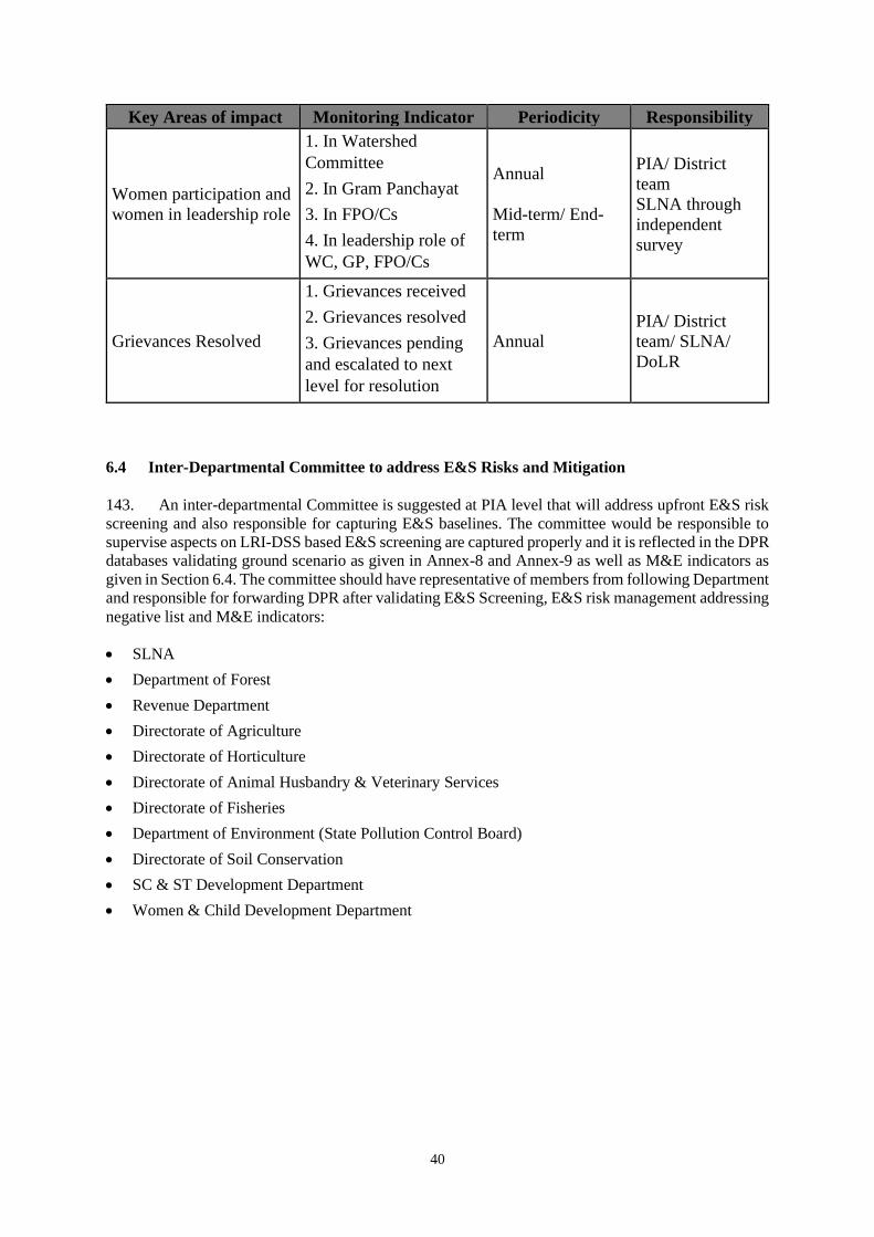
40
Key Areas of impact Monitoring Indicator Periodicity Responsibility
Women participation and
women in leadership role
1. In Watershed
Committee
2. In Gram Panchayat
3. In FPO/Cs
4. In leadership role of
WC, GP, FPO/Cs
Annual
Mid-term/ End-
term
PIA/ District
team
SLNA through
independent
survey
Grievances Resolved
1. Grievances received
2. Grievances resolved
3. Grievances pending
and escalated to next
level for resolution
Annual
PIA/ District
team/ SLNA/
DoLR
6.4 Inter-Departmental Committee to address E&S Risks and Mitigation
143. An inter-departmental Committee is suggested at PIA level that will address upfront E&S risk
screening and also responsible for capturing E&S baselines. The committee would be responsible to
supervise aspects on LRI-DSS based E&S screening are captured properly and it is reflected in the DPR
databases validating ground scenario as given in Annex-8 and Annex-9 as well as M&E indicators as
given in Section 6.4. The committee should have representative of members from following Department
and responsible for forwarding DPR after validating E&S Screening, E&S risk management addressing
negative list and M&E indicators:
• SLNA
• Department of Forest
• Revenue Department
• Directorate of Agriculture
• Directorate of Horticulture
• Directorate of Animal Husbandry & Veterinary Services
• Directorate of Fisheries
• Department of Environment (State Pollution Control Board)
• Directorate of Soil Conservation
• SC & ST Development Department
• Women & Child Development Department

41
ANNEXURES
ANNEX-1: LIST OF DOCUMENTS REVIEWED
1. IWMP Guideline 2008 and 2011
2. Implementation Manual for Suajla-III Project, 2017. Watershed Development Department,
Government of Karnataka.
3. Karnataka Watershed Development Project-II: Environmental Management Framework – Final
Report – December 2011
4. Social Assessment Report - Karnataka Watershed Development Project-II (Sujala-III), 2011
5. Supplementary Social Assessment Horticulture Components Karnataka Watershed Development
Project-II (Sujala-III)
6. Neeranchal: Strategic Environment and Social Assessment –Phase 1
7. Environment and Social Assessment Including Monitoring Plan for HP Mid-Himalayan
Watershed Development Project 2012
8. Guidelines for Evaluation of Preparatory Phase of IWMP Projects
9. Organizational Structure Involving Community for Effective Watershed Development 2011
10. Watershed Development in India - An Approach Evolving through Experience, World Bank,
2014
11. Benchmarking of Watershed Management Outcomes - Operational Guidelines, 2015,
Department of Land Resources, Ministry of Rural development, Government of India.
12. Census of India, 2011
13. Lobo, Crispino. An Institutional Study on Watershed Services: Improving Operational
Effectiveness and Impacts of the Integrated Watershed Development Program (IWMP), 2012
14. Prioritization of Rainfed Areas in India. NRAA, 2012
15. Rainfed Ecosystem in India – A Perspective. WASSAN, 2017
16. Odisha Gazette Notification dated August 17, 2012 on Creation/ Setting up Project Directors in
Watershed Offices in 26 Districts
17. Status of Agriculture in Odisha 2014-15
18. Odisha Profile 2018. Directorate of Economics and Statistics, Govt of Odisha

42
ANNEX-2: APPLICABLE LEGAL AND REGULATORY FRAMEWORK
144. The Government of India and the state government have enacted a range of laws, regulations,
and procedures relevant to managing the environmental and social effects of the proposed Program.
The following criteria were used to select the relevant legislation that best describes the country’s
system for managing the Program’s effects:
i. environmental and social policies,
ii. environmental and social protection laws, and
iii. laws, regulations, or guidelines in the relevant sectors and subsectors that provide
relevant rules or norms for environmental and social management.
Relevant National and State Programs
145. PMKSY: The Pradhan Mantri Krishi Sinchayee Yojana (PMKSY) has been formulated with
the vision of extending the coverage of irrigation ‘Har Khet ko pani’ (water to every farm)and
improving water use efficiency ‘More crop per drop' in a focused manner with end to end solution on
source creation, distribution, management, field application and extension activities. Watershed
Development Component of PMKSY (erstwhile IWMP), PMKSY has been formulated amalgamating
ongoing schemes viz. Accelerated Irrigation Benefit Programme (AIBP) of the Ministry of Water
Resources, River Development & Ganga Rejuvenation (MoWR, RD&GR), Integrated Watershed
Management Programme (IWMP) of Department of Land Resources (DoLR) and the On Farm Water
Management (OFWM) of Department of Agriculture and Cooperation (DAC).The Integrated
Watershed Management program was subsumed into the current PMKSY on 26 October 2015. The
core implementation activities of IWMP were unchanged and were as per the Common Guidelines 2008
(Revised 2011) of IWMP. Convergence with other Central and State Government schemes, remains the
top of the agenda for the program towards optimal and judicious utilization of financial resources.
146. IWMP: The Integrated Watershed Management Programme (IWMP) one of the Flagship
program of Government of India is under implementation by the Department of Land Resources since
2009-10 after integrating three area development program namely (a) Desert Development Programme
(DDP), (b) Drought Prone Areas Programme (DPAP) and (c) Integrated Wastelands Development
Programme (IWDP), for development of rainfed/ degraded land in the country.
147. The Desert Development Program (DDP) focused on reforestation to arrest the growth of hot
and cold deserts while the Drought Prone Areas Program (DPAP) concentrated on non-arable lands and
drainage lines for in-situ soil and moisture conservation, agro-forestry, pasture development,
horticulture and alternative land uses. The IWDP, on the other hand, made silvipasture, soil and
moisture conservation on wastelands the predominant activity. The NWDPRA was implemented with
a major thrust on arable land treatment, non-arable land treatment, drainage line treatment and livestock
development. Based on the implementation experience of the above listed watershed projects, the
Government of India realized the imperative of bringing about uniformity and harmonization in the
implementation of various watershed development projects and which lead IWMP with common
guidelines in 2008.
148. The main aims of IWMP are harnessing, conserving and developing degraded natural resources
such as soil, vegetative cover and water; prevention of soil run-off; rain water harvesting and recharging
of the ground water table; increasing the productivity of crops; introduction of multi-cropping and
diverse agro-based activities; promoting sustainable livelihoods and increasing the household incomes.
149. The project duration of IWMP project varies from 4-7 years. The major activities taken up
under IWMP inter-alia include ridge area treatment, drainage line treatment, soil and moisture
conservation, rainwater harvesting, nursery raising, afforestation, horticulture, pasture development,
livelihoods for asset less persons. The benefits that are expected to accrue under the IWMP include
increase in availability of surface water & groundwater, changes in cropping pattern from one to two
crops annually, increase in fodder availability and increase in milk yield, increase in agriculture
productivity and increase in employment opportunities and household income.

43
150. IWMP is more diverse and socially inclusive compared to earlier watershed guidelines. It also
focuses on:
a) Securing rural livelihood of small and marginal farmers and the landless in terms of food
security and income.
b) Reducing distress migration from watersheds
c) Social audits are built in the process of IWMP implementation
d) Gram sabha’s participation planning and management
e) No. of CBOs/ SHGs/ Micro-enterprise formed and linked to market
f) Productivity enhancement and livelihoods were given priority along with conservation
measures
151. The Guiding Principles as mentioned in the IWMP Common Guideline 2011 is as below:
a. Equity and Gender sensitivity: Watershed Development Projects should be considered as
levers of inclusiveness. Project Implementing Agencies (PIAs) must facilitate the equity
processes such as a) enhanced livelihood opportunities for the poor through investment in
their assets and improvements in productivity and income, b) improving access of the poor,
especially women to the benefits, c) enhancing role of women in decision making processes
and their representation in the institutional arrangements and d) ensuring access to usufruct
rights from the common property resources for the resource poor.
b. Decentralization: Project management would improve with decentralization, delegation and
professionalism. Establishing suitable institutional arrangements within the overall
framework of the Panchayati Raj Institutions (PRIs), and the operational flexibility in norms
to suit varying local conditions will enhance decentralization. Empowered committees with
delegation to rationalize the policies, continuity in administrative support and timely release
of funds are the other instruments for effective decentralization.
c. Facilitating Agencies: Social mobilization, community organization, building capacities of
communities in planning and implementation, ensuring equity arrangements, etc. need
intensive facilitation. Competent organizations including voluntary organizations with
professional teams having necessary skills and expertise would be selected through a rigorous
process and may be provided financial support to perform the above specific functions.
d. Centrality of Community Participation: Involvement of primary stakeholders is at the
centre of planning, budgeting, implementation, and management of watershed projects.
Community organizations may be closely associated with and accountable to Gram Sabhas in
project activities.
e. Capacity Building and Technology Inputs: Considerable stress would be given on capacity
building as a crucial component for achieving the desired results. This would be a continuous
process enabling functionaries to enhance their knowledge and skills and develop the correct
orientation and perspectives thereby becoming more effective in performing their roles and
responsibilities. With current trends and advances in information technology and remote
sensing, it is possible to acquire detailed information about the various field level
characteristics of any area or region. Thus, the endeavor would be to build in strong
technology inputs into the new vision of watershed programs.
f. Monitoring, Evaluation and Learning: A participatory, outcome and impact-oriented and
user-focused monitoring, evaluation and learning system would be put in place to obtain
feedback and undertake improvements in planning, project design and implementation.
g. Organizational Restructuring: Establishing appropriate technical and professional support
structures at national, state, district and project levels and developing effective functional
partnerships among project authorities, implementing agencies and support organizations
would play a vital role.
44
152. MGNREGA: Mahatma Gandhi National Rural Employment Guarantee Act (MGNREGA)
initiated by the MoRD23. The MGNREGA aims to provide a strong social safety net for the vulnerable
groups by providing a fall-back employment source, when other employment alternatives are scarce or
inadequate Through the process of providing employment on works that address causes of chronic
poverty such as drought, deforestation and soil erosion, the Act seeks to strengthen the natural resource
base of rural livelihoods and create durable assets in rural areas. It aims at empowering the rural poor
through the processes of a rights-based law and fostering conditions for inclusive growth.
Watershed development works mainly the NRM works predominantly the water and soil conservation,
afforestation and land development works are allowed24 to be taken up in convergence with MGNREGS
and government orders and guidelines have been issued by the Ministry of Rural Development (MoRD)
with this effect. States including Odisha has been using the convergence with MGNREGS to undertake
watershed development activities.
153. Deendayal Antyodaya Yojana-National Rural Livelihoods Mission (DAY-NRLM): The
DAY-NRLM is a centrally sponsored program that aims at eliminating rural poverty through promotion
of multiple livelihoods for each rural poor household. The DAY-NRLM seeks to reach out to all rural
poor households and impact their livelihoods significantly by 2024–25. This is sought to be achieved
through universal social mobilization, inter alia, organizing one woman member from each rural poor
household into Self Help Groups (SHGs), their training and capacity building, facilitating their micro-
livelihoods plans, and enabling them to implement their livelihoods plans through accessing financial
resources from their own institutions and banks. The mission aims at creating efficient and effective
institutional platform for the rural poor, enabling them to increase household income through
sustainable livelihood enhancement and improved access to financial services. NRLM is
complementing rural poor groups with knowledge, information, skills, tools, finances and
collectivization. As NRLM expands to watershed areas, convergence is sought to build linkages for
women SHGs already created under the watershed program towards skill development initiatives of
NRLM and enhancing further income generation and livelihood activities. Both MoRD and DoLR have
issued guidelines with this effect and are being followed in various states including Odisha.
154. Panchayats (Extension to the Scheduled Areas) Act, 1996:
To mainstream the tribal issues in the development process, without disturbing or destroying their
cultural identity and socio- economic milieu, the Parliament extended the provisions of 73rd Amendment
Act to the Scheduled Areas by passing Provisions of Panchayats (Extension to the Scheduled Areas)
Act, 1996. The Panchayat (Extension to the Scheduled Areas) Act, 1996, commonly known as PESA,
legally recognizes Scheduled Tribe’s own systems of self-governance. The Gram Sabha of the village
becomes the focal institution, endowed with significant powers. Under section 4(d) of PESA: "every
Gram Sabha shall be competent to safeguard and preserve the traditions and customs of the people, their
cultural identity, community resources and the customary mode of dispute resolution." PESA legally
recognizes the right of tribal communities to govern themselves through their own systems of self-
government and also acknowledges their traditional rights over natural resources. The salient feature of
the Panchayats (Extension to the Scheduled Areas) Act includes the following:
1. Legislation on Panchayats shall be in conformity with the customary law, social and religious
practices and traditional management practices of community resources;
2. Habitation or a group of habitations or a hamlet or a group of hamlets comprising a community
and managing its affairs in accordance with traditions and customs; and shall have a separate
Gram Sabha.
3. Every Gram Sabha to safeguard and preserve the traditions and customs of people, their cultural
identity, community resources and the customary mode of dispute resolution.
23 Although EAS and MGNREGA are employment-oriented programs, priority has been given to rejuvenation of natural
resources, including water and soil conservation.
24https://nrega.nic.in/netnrega/writereaddata/Convergence/HP/circulars/cir310.pdf

45
4. The Gram Sabhas have roles and responsibilities in approving all development works in the
village, identify beneficiaries, issue certificates of utilization of funds; powers to control
institutions and functionaries in all social sectors and local plans.
5. Gram Sabhas or Panchayats at appropriate level shall also have powers to manage minor water
bodies; power of mandatory consultation in matters of land acquisition; resettlement and
rehabilitation and prospecting licenses/mining leases for minor minerals; power to prevent
alienation of land and restore alienated land; regulate and restrict sale/consumption of liquor;
manage village markets, control money lending to STs; and ownership of minor forest produce.
6. The provisions of Panchayats with certain modification and exceptions have been extended to
the Schedule V areas.
In line with the PESA Act, the Government of Odisha has formulated rules for the Panchayats
(Extension to Scheduled Areas) Act, 1996.
155. Odisha Pani Panchayat Act: High dependency on agriculture in the state demands efficient
and equitable supply and distribution of water and its optimal utilization. It is also required that scientific
and systematic development and maintenance of irrigation infrastructure by which water will be made
available to the farmers. It is realized that decentralized system of operation and management of
irrigation structures and water distribution networks will yield better result where farmers will
participate and take up the ownership of irrigation systems at their field level. Participatory Irrigation
Management (PIM) was conceived as the vehicle to improve water distribution mechanism and
attending water use efficiency along with maintenance of the structures. It was planned to promote
farmers organizations, in shape of Pani Panchayat, who will take up required responsibility for water
distribution, management and maintenance of the irrigation structures. In this context, the Orissa Pani
Panchayat Act, 2002, was enacted to ensure participation of the farmers’ / water users in the
management of irrigation systems and for matters connected therewith or incidental thereto (The Orissa
Gazette, No.1053, 8 July, Cuttack: 2002). The object of the PP is “to promote and secure distribution
of water among its users, adequate maintenance of the irrigation system, efficient and economical
utilization of water to optimize agricultural production, to protect the environment, and to ensure
ecological balance by involving the farmers, inculcating a sense of ownership of the irrigation system
in accordance with the water budget and the operational plan”.
156. Tribal sub plan (TSP) and Scheduled Caste sub plan (SCSP): The strategy of Tribal Sub
Plan (TSP) has been in force since 1974, to ensure adequate flow of plan resources for the development
of Scheduled Tribes in proportion to their population. The strategy of Scheduled Castes Sub Plan
(SCSP) (earlier known as the Special Component Plan for Scheduled Castes) has been in force since
1979-80, to ensure a proportionate flow of plan resources for the development of Scheduled Castes.
TSP funds are earmarked by the state through their annual budget under each of the department’s budget
including the budget of DSC&WD/ DoA in proportion to the tribal population living in the state.
157. A brief summary of environmental and social laws, regulations and policies that are relevant to
the proposed Program is mentioned in table below.
Table (A2.1): Relevant Environmental and Social Laws, Regulations and Policies
Sl.
No.
Applicable Act/
Regulation/ Policy
Objective and Provisions Relevance to the Program
and key Findings
1 The Constitution of India
(especially, Articles
15,16 and 46)
The Indian Constitution (Article 15)
prohibits any discrimination based on
religion, race, caste, sex, and place of
birth. Article 16 refers to the equality of
opportunity in matters of public
employment. Article 46 directs the state to
promote with special care the educational
and economic interests of the weaker
sections of the people, particularly of the
Scheduled Castes and the Scheduled
Relevant to the overall
Program

46
Sl.
No.
Applicable Act/
Regulation/ Policy
Objective and Provisions Relevance to the Program
and key Findings
Tribes and also directs the state to protect
them from social injustice and all forms of
exploitation.
2 Right to Information Act,
2005
Provides a practical regime of right to
information for citizens to secure access to
information under the control of Public
Authorities. The act sets out (a)
obligations of public authorities with
respect to provision of information; (b)
requires designating of a Public
Information Officer; (c) process for any
citizen to obtain information/disposal of
request, etc.; and (d) provides for
institutions such as Central Information
Commission/State Information
Commission
Relevant as all documents
pertaining to the Program
requires be disclosed to
public.
3 Minimum wages Act,
1948
This act ensures minimum wages that
must be paid to skilled and unskilled
labors. The employer shall pay to every
employee engaged in scheduled
employment under him, wages at the rate
not less than the minimum wages fixed by
such notification for that class of
employee without any deductions except
authorized.
Applicable to the overall
Program
4 Child labour (prohibition
and regulation) Act
1986; 2015
This act prohibits the engagement of
children below 14 and 15 years in certain
types of occupations and regulates the
condition of work of children in other
occupations. No child shall be employed
or permitted to work in any of the
occupations set forth in Part A of the
schedule, processes set forth in Part B of
the schedule which includes building and
construction industry.
Applicable to hiring contract
labour for construction
activities
5 The Right to Fair
Compensation and
Transparency in Land
Acquisition,
Rehabilitation and
Resettlement Act, 2013
Aims to ensure, a humane, participative,
informed and transparent process for land
acquisition with least disturbance to the
owners of the land and other affected
families and provide just and fair
compensation to the affected families
whose land has been acquired or proposed
to be acquired or those that are affected by
such acquisition and make adequate
provisions for their rehabilitation and
resettlement and for ensuring that the
cumulative outcome of compulsory
acquisition should be that affected persons
become partners in development leading
to an improvement in their post-
acquisition social and economic status.
Not applicable as no land
acquisition or resettlement is
anticipated.
6 The Sexual Harassment
of Women at Workplace
An act that aims at providing a sense of
security at the workplace that improves
women’s participation in work and results
in their economic empowerment. It
Relevant and applicable to
all formal institutions
including WDD

47
Sl.
No.
Applicable Act/
Regulation/ Policy
Objective and Provisions Relevance to the Program
and key Findings
(Prevention, Prohibition
and Redressal) Act, 2013
requires an employer to set up an “Internal
Complaints Committee” (ICC) and the
Government to set up a ‘Local Complaints
Committee’ (LCC) at the district level to
investigate complaints regarding sexual
harassment at workplace and for inquiring
into the complaint in a time bound manner.
The ICC need to set up by ever
organization and its branches with more
than 10 employees.
7 Fifth Scheduled Areas as
in the Constitution of
India
In the Scheduled Areas, involvement of
tribal councils and communities,
incorporating their views and culture
specific needs will enhance their
participation in the Program. Under the
provisions of Fifth Scheduled Areas, the
State should set up a Tribes Advisory
Council (TAC) to advise the State
Government on matters of welfare and
development of the Scheduled Tribes in
the State.
Applicable as AP has
Schedule V areas.
8 The Environment
(Protection) Act No.29
of 1986
• Under this Act, the central government
is empowered to take measures
necessary to protect and improve the
quality of the environment by setting
standards for emissions and discharges;
regulating the location of industries;
management of hazardous wastes, and
protection of public health and welfare.
• This encompasses all legislations
providing for the protection of
environment in the country.
It includes the power to direct the closure,
prohibition or regulation of any industry,
operation or process by the government
• Relevant to Water
conservation, Agriculture,
Forestry, Pasture lands,
Horticulture, etc. activities
• Preservation of air and
water quality.
• Control of pesticides
&insecticide runoff.
Control dust pollution due
to quarrying, which might
harm the vegetation.
9 Water and Air
(Prevention and Control
of Pollution) Act, 1974
& 1981 (Central Act 6 of
1974) as amended
in1988
• This Act prohibits the discharge of
pollutants into water bodies beyond a
given standard and lays down penalties
for noncompliance.
• Water act includes the maintenance or
restoring the wholesomeness of the
water.
Air act restricts the operation of any
industrial plant in an air pollution control
area without a valid consent
Not relevant to project
activities.
10 Forest (Conservation)
Act No. 69 of 1980 and
amended in 1988
• This Act restricts the powers of the state
in respect of de-reservation of forests and
use of forestland for non-forest purposes.
• All diversions of forestlands to any non-
forest purpose, even if the area is
privately owned, require approval of the
central government.
• Leases of forest land to any organization
or individual require approval of the
central government.
• Relevant to Forestry and
Agriculture components.
• Conservation of
indigenous biomass.
• Retar evapotranspiration,
generates organic manure,
increased soil flora &
fauna.
Permission is to be obtained
from the Forest Department
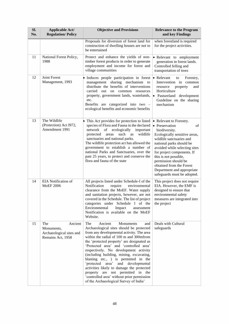
48
Sl.
No.
Applicable Act/
Regulation/ Policy
Objective and Provisions Relevance to the Program
and key Findings
Proposals for diversion of forest land for
construction of dwelling houses are not to
be entertained
when forestland is required
for the project activities.
11 National Forest Policy,
1988
Protect and enhance the yields of non-
timber forest products in order to generate
employment and income for forest and
village communities
• Relevant to employment
generation in forest lands.
Controlled felling and
transportation of trees
12 Joint Forest
Management, 1993 • Induces people participation in forest
management sharing mechanism to
distribute the benefits of interventions
carried out on common resources
property, government lands, wastelands,
etc.
Benefits are categorized into two –
ecological benefits and economic benefits
• Relevant to Forestry,
Intervention in common
resource property and
Horticulture
• Pastureland development
Guideline on the sharing
mechanism
13 The Wildlife
(Protection) Act I972,
Amendment 1991
• This Act provides for protection to listed
species of Flora and Fauna in the declared
network of ecologically important
protected areas such as wildlife
sanctuaries and national parks.
The wildlife protection act has allowed the
government to establish a number of
national Parks and Sanctuaries, over the
past 25 years, to protect and conserve the
flora and fauna of the state
• Relevant to Forestry.
• Preservation of
biodiversity.
Ecologically sensitive areas,
wildlife sanctuaries and
national parks should be
avoided while selecting sites
for project components. If
this is not possible,
permission should be
obtained from the Forest
Department and appropriate
safeguards must be adopted.
14 EIA Notification of
MoEF 2006
All projects listed under Schedule-I of the
Notification require environmental
clearance from the MoEF. Water supply
and sanitation projects, however, are not
covered in the Schedule. The list of project
categories under Schedule I of the
Environmental Impact assessment
Notification is available on the MoEF
Website.
This project does not require
EIA. However, the EMF is
designed to ensure that
environmental safety
measures are integrated into
the project
15 The Ancient
Monuments,
Archaeological sites and
Remains Act, 1958
The Ancient Monuments and
Archaeological sites should be protected
from any developmental activity. The area
within the radial of 100 m and 300mfrom
the ‘protected property’ are designated as
‘Protected area’ and ‘controlled area’
respectively. No development activity
(including building, mining, excavating,
blasting etc., ) is permitted in the
‘protected area’ and developmental
activities likely to damage the protected
property are not permitted in the
‘controlled area’ without prior permission
of the Archaeological Survey of India’
Deals with Cultural
safeguards
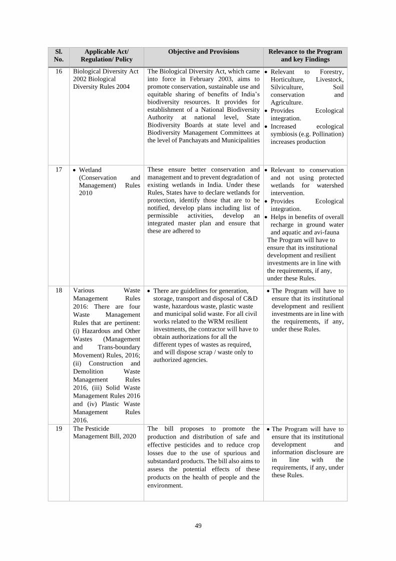
49
Sl.
No.
Applicable Act/
Regulation/ Policy
Objective and Provisions Relevance to the Program
and key Findings
16 Biological Diversity Act
2002 Biological
Diversity Rules 2004
The Biological Diversity Act, which came
into force in February 2003, aims to
promote conservation, sustainable use and
equitable sharing of benefits of India’s
biodiversity resources. It provides for
establishment of a National Biodiversity
Authority at national level, State
Biodiversity Boards at state level and
Biodiversity Management Committees at
the level of Panchayats and Municipalities
• Relevant to Forestry,
Horticulture, Livestock,
Silviculture, Soil
conservation and
Agriculture.
• Provides Ecological
integration.
• Increased ecological
symbiosis (e.g. Pollination)
increases production
17 • Wetland
(Conservation and
Management) Rules
2010
These ensure better conservation and
management and to prevent degradation of
existing wetlands in India. Under these
Rules, States have to declare wetlands for
protection, identify those that are to be
notified, develop plans including list of
permissible activities, develop an
integrated master plan and ensure that
these are adhered to
• Relevant to conservation
and not using protected
wetlands for watershed
intervention.
• Provides Ecological
integration.
• Helps in benefits of overall
recharge in ground water
and aquatic and avi-fauna
The Program will have to
ensure that its institutional
development and resilient
investments are in line with
the requirements, if any,
under these Rules.
18 Various Waste
Management Rules
2016: There are four
Waste Management
Rules that are pertinent:
(i) Hazardous and Other
Wastes (Management
and Trans-boundary
Movement) Rules, 2016;
(ii) Construction and
Demolition Waste
Management Rules
2016, (iii) Solid Waste
Management Rules 2016
and (iv) Plastic Waste
Management Rules
2016.
• There are guidelines for generation,
storage, transport and disposal of C&D
waste, hazardous waste, plastic waste
and municipal solid waste. For all civil
works related to the WRM resilient
investments, the contractor will have to
obtain authorizations for all the
different types of wastes as required,
and will dispose scrap / waste only to
authorized agencies.
• The Program will have to
ensure that its institutional
development and resilient
investments are in line with
the requirements, if any,
under these Rules.
19 The Pesticide
Management Bill, 2020
The bill proposes to promote the
production and distribution of safe and
effective pesticides and to reduce crop
losses due to the use of spurious and
substandard products. The bill also aims to
assess the potential effects of these
products on the health of people and the
environment.
• The Program will have to
ensure that its institutional
development and
information disclosure are
in line with the
requirements, if any, under
these Rules.
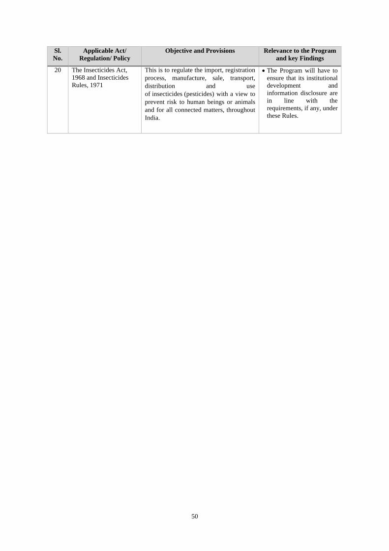
50
Sl.
No.
Applicable Act/
Regulation/ Policy
Objective and Provisions Relevance to the Program
and key Findings
20 The Insecticides Act,
1968 and Insecticides
Rules, 1971
This is to regulate the import, registration
process, manufacture, sale, transport,
distribution and use
of insecticides (pesticides) with a view to
prevent risk to human beings or animals
and for all connected matters, throughout
India.
• The Program will have to
ensure that its institutional
development and
information disclosure are
in line with the
requirements, if any, under
these Rules.

51
ANNEX-3(A): CORE PRINCIPLE #1: PROGRAM E&S MANAGEMENT SYSTEMS
Sl.
No.
Planning
Elements Management System Capacity, Risks and Gaps Recommendations to align with Core Principle
Core Principle #1: Program E&S management systems are designed to 1.(a) promote E&S sustainability in the Program design; (b) avoid, minimize, or mitigate
adverse impacts; and (c) promote informed decision-making relating to a Program’s E&S effects
1. Adequate legal
and regulatory
framework
• Planning and implementation of the entire
watershed program in Odisha follow the common
guideline 2011 as recommended by the WDC-
PMKSY i.e. involvement of primary stakeholders
is at the centre of planning of watershed projects.
The Project Implementing Agency (PIA) provides
necessary technical guidance to the Village level
institutions - Watershed Committees (WCs), Self-
Help Groups (SHGs) and User Groups (UGs) for
preparation of DPR through a strong Participatory
Rural Appraisal (PRA) exercise.
• MGNREGS is also used to work on watershed
development but remain in the ambit of
MGNREGA provisions and processes.
• In addition, the legislative and regulatory
provisions under various acts such as RTI Act
2005; Minimum Wages Act 1948 (with
amendments); Child Labour (prohibition and
regulation) Act 1986, 2015; LARR, 2013 with
further amendments; and provision under the
constitution and Fifth schedule areas are applicable
as the case maybe and provide for larger umbrella
of guidance and framework.
• While the legislative and regulatory
provisions are adequate, also the
watershed guidelines spell out clear roles
and responsibility, and the process to be
adopted for watershed planning and
implementation, some risk emerges from
its weak compliance as it requires
enabling institutional and technical
capacity for compliance.
• There is risk of skipping the process of
community participation completely as
the objective of the initial participation
and consultation process as in case of
IWMP/ WDC-PMKSY is to reach to
watershed plan/DPR, and which in case
of LRI based process the watershed plan/
DPR draft is prepared using computer
based digital support system.
• Protocol/ SOP to be prepared and adopted by
the state for how science-based input (such as
LRI data) for DPR preparation is translated for
the community and the detailed process
guideline for undertaking the consultations with
community during DPR preparation and before
approving and/or passing the DPR in Gram
Sabha for further considerations.
• Build the capacities of frontline workers and
NGOs/Agencies associated on improved
mechanism and also on the process of social
mobilization and ecological conservation and
environmental safeguard issues.
•
2 Key E&S risks
that requires
screening and
management of
risk
• There is no system of screening of E&S risks given
the size of physical structures are quite small in
size.
• This may lead to adversely affecting
some of the physical and cultural
resources such as sacred groves and other
such sites and structures.
• E&S screening to be instituted based on
screening format (see Annex-VIII) during
watershed plan/ DPR preparation.

52
Sl.
No.
Planning
Elements Management System Capacity, Risks and Gaps Recommendations to align with Core Principle
3 Strategic,
technical and
site alternatives
• No activities under the watershed project
components are taken-up if it involves physical
displacement of local people, either from their
residences and/or commercial places;
• Activities / treatments which involve
encroachment of forest land require permission of
the Forest & Environment Department. Provision
for approval and sanction of community forest
rights (CFR) and individual forest rights (IFR)
under the FRA support watershed treatments in
forest lands.
• No activities are undertaken in areas having
sensitive natural habitats, wetlands and ecological
sensitive areas.
• Areas where submergence may occur is not
considered.
• The planning process should include
analysis of alternative designs and sites,
or consideration of "no option".
• Assessment procedures and mitigation
measures have been put into place
through the EMF so that any likely
negative impacts on the natural
environment are minimized.
• Any physical displacement, program
interventions in sensitive natural habitats,
wetlands and ecological sensitive areas, and
areas where submergence may occur will not be
taken up under the project and will be part of
excluded activities under the project.
• The schemes to be taken up under the project
would not convert or degrade natural habitats.
• Marginal groups should be given awareness
training on illegal conversion of forest land to
agriculture land.
• Though project is not financing procurement of
any pesticides but supports environmentally
sound pest management, including integrated
pest management, but does not prohibit the use
of highly hazardous pesticides.
4 Assessment of
potential
cumulative, and
trans-boundary
impacts
• The process of selection of watershed for treatment
is based on regional assessment of environment
especially soil health and water availability in the
rainfed area to enhance productivity of the crops.
Baseline is created to assess and inform the
changes due to intervention.
• One of the important cumulative impacts of
watershed development is reduction in poverty and
reduced forced migration. However, no systematic
assessment has been done to quantify the
magnitude of the reduction.
• Agriculture run-off with chemical
fertilizer, pesticide & insecticide may
pollute surface water as well as
groundwater quality
• Increased use of water may reduce
ground water level in shallow water table
• Change in cropping pattern (introduction
of cash crops) due to increased
availability of water may lead to eventual
over drawl.
• There is risk of decrease in downstream
surface water flow if water is stored in
upper ridges.
• Regular monitoring of environment parameters
in project areas. Parameters will be ground
water level and quality, soil testing to ascertain
there is no erosion.
• Current scale of planning is usually at the micro
(500 Ha) or the sub watershed (5000 Ha) scale
but does not take into account impact of existing
structures upstream and impact on downstream
users. A World Bank study carried out in
Gujarat25 suggests that a hydrological
assessment at the catchment level should
precede micro or sub watershed level planning
to ensure that externalities are properly
acknowledged and addressed.
25Catchment Assessment and Planning for Summary report June 2015 Watershed Management

53
Sl.
No.
Planning
Elements Management System Capacity, Risks and Gaps Recommendations to align with Core Principle
• Evaluate how effectively IWMP works have
been carried out in forestlands, especially where
ridges are under forest cover
5 Institutional
responsibilities
and resources to
support
implementation
• The WDC-PMKSY program guide clearly
articulate the institutional responsibilities at
different level of program implementation right
from national, state, district, Block/ PIA, GP and
village level.
• However, in the existing implementation chain,
there is no articulation of individual or agency
responsible for implementing the E&S activities
and monitoring the same.
• The current institutional mechanism
lacks in E&S screening, implementing
and monitoring of E&S effects arising
out of program activities.
• The state proposes to ensure E&S officer at the
state level and well as designate an official at
district level for the proposed project.
• However, there is need to train frontline
workers in environmental issues so that they can
monitor E&S impact or appoint third party
Agency/NGOs for monitoring and addressing
E&S concerns.
• DPR preparation through participatory
approach, community training, activity
supervision-monitoring and review, build
indigenous technical knowledge, post project
operation and maintenance of project assets.
7 Responsiveness,
inclusion and
accountability
through
stakeholder
consultation and
dissemination
• The current watershed program aims not only to
improve the soil and water conservation but also
improve the livelihood and income of farmers as
well as skill-based opportunities and income
generating activities for women and landless.
• The guideline provides for about 10% of
funds for livelihood improvement of
landless and vulnerable. Program also
attempts to link women SHGs to SRLM.
However, there is no systematic
assessment of its impact on women and
landless has been assessed.
• The WDC-PMKSY guideline does
provide for building of accountability of
local institutions involved with a detailed
process of consultation with community
and other stakeholders. This requires
strengthening for the new LRI based
watershed planning and implementation.
• A detailed participatory mechanism to build
accountability among local institutions and state
level institutions including those responsible for
DPR preparation requires strengthening.
• Impact assessment study of watershed activities
including focus on landless and vulnerable
needs to be conducted and the findings to be
used for filling gaps in future program activities.
• A comprehensive Stakeholders Engagement
Plan has to be evolved and implemented

54
Sl.
No.
Planning
Elements Management System Capacity, Risks and Gaps Recommendations to align with Core Principle
8 Responsive
GRM • The current grievance redress mechanism is based
on RTI Act, CM’s grievance cell, Odisha State
Grievance Redressal Portal: e-Abhijog portal
(https://cmgcodisha.gov.in/).
• It requires the beneficiaries to travel to
other places at Taluka/ District level to
register any complaint. Also, one has to
be literate to write down the complaint.
• DSC&WD need to address proper mechanism
for GRM and strengthen the complaint
registering and resolving mechanism.
ANNEX-3(B): CORE PRINCIPLE #2: NATURAL HABITAT AND PHYSICAL AND CULTURAL RESOURCES
Sl.
No. Planning Elements Management System Capacity, Risks and Gaps
Recommendations to align with Core
Principle
1 Identification and screening
of potentially important
biodiversity and cultural
resource areas
With departure from detailed
consultative processes being used for
bottoms up planning to LRI based top
down planning with inadequate
participation and consultation on the
draft plan, there is no mechanism to
screen out physical cultural resources
such as ‘sacred groves’ etc.
• There is risk of disturbing the sacred groves
unknowingly may be possible as the DPR
preparation is more of computer-based
algorithms to plan for each plot and prepare DPR
• The vegetative cover for enhanced NRM and
ecosystem services on the lines of watershed
interventions that result in losses of biodiversity
and forest areas
• Introduction of exotic/ alien species of grasses
and fodder crops to meet the demand of fodder
that dominate the local species.
• Change in diversity of flora and fauna
• Increased risk of forest fire, habitat and grazing
resources loss
• Change in cropping pattern can impact the
natural habitat especially of avi-fauna
• Screening to be instituted along with
community consulting to rule out any
adverse impact. At the screening stage
only there is need of identifying
structures of cultural and religious
importance.
• Support establishing village level
Biodiversity Management Committees
and preparation of Biodiversity
Registers (under National Biodiversity
Act) that not only documents traditional
knowledge, but also provide NRM
solutions
2 The conservation,
maintenance and
rehabilitation of natural
habitats; avoid the
significant conversion or
degradation of critical
natural habitats and if
The schemes to be taken up under the
project would not convert or degrade
natural habitats.
However, assessment procedures and
mitigation measures have been put into
place through the EMF so that any likely
• Many natural habitats, including forestland, non-
forestland with tree cover, pastures/meadows,
common property resource etc. May be involved
and therefore, these areas do not undergo any
degradation and people dependent on these
common property resources continue to enjoy the
access and rights they currently are entitled
• Natural habitats, including forestland,
non-forestland will be maintained
according to National Environment
Policy 2006; National Water Resources
Policy 2002 and National Biodiversity
Strategy and Action Plan (NBSAP)

55
Sl.
No. Planning Elements Management System Capacity, Risks and Gaps
Recommendations to align with Core
Principle
avoiding the significant
conversion of natural
habitats is not technically
feasible, includes measures
to mitigate or offset impact
or programme activities
negative impacts on the natural
environment are minimized. • Activities under IWMP focusing on
increasing area under vegetation and
grasses through afforestation, increase
in availability of green and dry fodder
both in quality and quantity, increase in
availability of crop stalks as dry fodder
and habitat improvement through soil
and moisture conservation works.
3 Physical cultural property
and as warranted, provides
adequate measures to avoid,
minimize, or mitigate such
effects.
Purpose is to assist in the preservation of
cultural property, such as sites having
archaeological, paleontological,
historical, religious and unique cultural
values.
Generally, seeks to assist in their
preservation and avoid their elimination.
Discourages financing of projects that
will damage cultural property.
• Based on the perception of the community,
physical verification and related consultation, it
can be inferred that as such there are no such
cultural properties like sites having
archaeological (prehistoric), paleontological,
historical, religious and unique natural values
will not impact in the watershed area. Overall,
cultural aspects can be classified into
community-oriented, caste oriented and
individual oriented. No specific risks to any of
the above cultural aspects were observed at
present or as potential due to IWMP activity.
• At the screening stage only there is need
of identifying cultural properties like
sites having archaeological
(prehistoric), paleontological, historical,
religious and unique natural values
along with ecological sensitive areas,
natural habitats, migratory routes and
cultural property so that proper impact
mitigation is devised before project
initiation.
• Afforestation should be done in the
government, village common /private
land, forest land and waste lands
depending on local vegetation, terrain,
soil type, land tenure and local
requirements. This will reduce risk of
soil erosion.
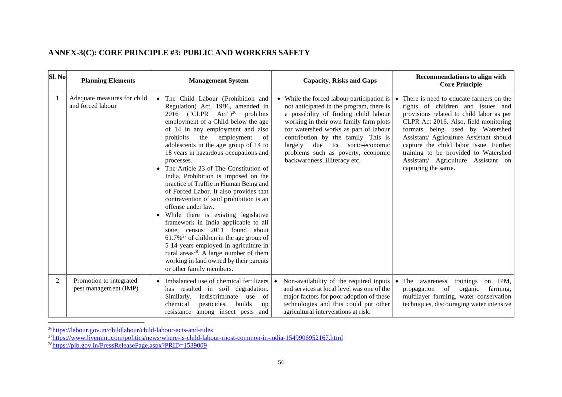
56
ANNEX-3(C): CORE PRINCIPLE #3: PUBLIC AND WORKERS SAFETY
Sl. No. Planning Elements Management System Capacity, Risks and Gaps
Recommendations to align with
Core Principle
1 Adequate measures for child
and forced labour • The Child Labour (Prohibition and
Regulation) Act, 1986, amended in
2016 ("CLPR Act")26 prohibits
employment of a Child below the age
of 14 in any employment and also
prohibits the employment of
adolescents in the age group of 14 to
18 years in hazardous occupations and
processes.
• The Article 23 of The Constitution of
India, Prohibition is imposed on the
practice of Traffic in Human Being and
of Forced Labor. It also provides that
contravention of said prohibition is an
offense under law.
• While there is existing legislative
framework in India applicable to all
state, census 2011 found about
61.7%27 of children in the age group of
5-14 years employed in agriculture in
rural areas28. A large number of them
working in land owned by their parents
or other family members.
• While the forced labour participation is
not anticipated in the program, there is
a possibility of finding child labour
working in their own family farm plots
for watershed works as part of labour
contribution by the family. This is
largely due to socio-economic
problems such as poverty, economic
backwardness, illiteracy etc.
• There is need to educate farmers on the
rights of children and issues and
provisions related to child labor as per
CLPR Act 2016. Also, field monitoring
formats being used by Watershed
Assistant/ Agriculture Assistant should
capture the child labor issue. Further
training to be provided to Watershed
Assistant/ Agriculture Assistant on
capturing the same.
2 Promotion to integrated
pest management (IMP) • Imbalanced use of chemical fertilizers
has resulted in soil degradation.
Similarly, indiscriminate use of
chemical pesticides builds up
resistance among insect pests and
• Non-availability of the required inputs
and services at local level was one of the
major factors for poor adoption of these
technologies and this could put other
agricultural interventions at risk.
• The awareness trainings on IPM,
propagation of organic farming,
multilayer farming, water conservation
techniques, discouraging water intensive
26https://labour.gov.in/childlabour/child-labour-acts-and-rules 27https://www.livemint.com/politics/news/where-is-child-labour-most-common-in-india-1549906952167.html 28https://pib.gov.in/PressReleasePage.aspx?PRID=1539009

57
Sl. No. Planning Elements Management System Capacity, Risks and Gaps
Recommendations to align with
Core Principle
diseases. The technologies like, IPM,
water management, are being
disseminated by the extension
agencies like state agricultural
department and state agricultural
universities to avoid further problems
of crop production.
• Lack of knowledge regarding bio-
pesticides and bio-fertilizers is another
concern.
crop are regularly done by DSC&WD
and Agriculture and Horticulture
Department.
3 Production, management,
storage, transportation and
disposal of hazardous
materials
• The Environment (Protection) Act
No.29 of 1986, the central government
is empowered to take measures
necessary to protect and improve the
quality of the environment by setting
standards for emissions and
discharges; regulating the location of
industries; management of hazardous
wastes, and protection of public health
and welfare.
• This encompasses all legislations
providing for the protection of
environment in the country.
• It includes the power to direct the
closure, prohibition or regulation of
any industry, operation or process by
the government
• There should be official reports to the
national level and follow-up enquiries in
the event of fires, spills, poisonings, and
other hazardous events.
• The awareness trainings on IPM,
propagation of organic farming,
multilayer farming, water conservation
techniques, discouraging water
intensive crop need to be done.
There is very little risk associated with
hazardous material in construction and
operation phase.
For agriculture related activity:
• Pesticides should be transported in
well-sealed and labelled containers,
boxes or bags.
• Preservation of air and water quality
• Control of pesticides & insecticide
runoff
• Control dust pollution due to
quarrying, which might harm the
vegetation
4 Safety for labors and public
at construction sites • The Environment (Protection) Act
No.29 of 1986, the central government
is empowered to take measures
necessary for protection of public
health and welfare.
• All legal enactments related to
protection of labors and labor welfare
During the planning and construction phase
there will be activities related to trenching,
civil construction, storage of raw and waste
materials. Improper management of the
above activities may lead to safety and
health risks among the public and labors.
There is a need to devise mitigation
measures which will minimize risks such
as:
• Proper refilling of trenches and sampling
sites with soil
• Covering of storage areas with tarpaulin
• Proper barriers and signage in excavated
areas to prevent public from accessing
the areas

58
ANNEX-3(D): CORE PRINCIPLE #4: LAND ACQUISITION AND RESETTLEMENT
Sl.
No. Planning Elements Management System Capacity, Risks and Gaps
Recommendations to align with Core
Principle
1 Avoid and minimize land
acquisition and
involuntary resettlement
and related adverse
impacts
• The Right to Fair Compensation and
Transparency in Land Acquisition,
Rehabilitation and Resettlement
(RFCTLARA) Act, 2013 and further
amendments in 2015 provides for a
detailed process for any land
acquisition, compensation, and dealing
with involuntary resettlements and is in
line with World Bank principles.
• There is a clear formal mechanism
detailed out under the RFCTLARA
Act on processes to be followed
including process o consultations and
taking consent.
• The analysis of other watershed projects
in India and in Odisha suggests that in
watershed projects there is no land
acquisition involved and hence the risk
relating to acquiring land and
resettlement is minimal or non-existent.
The civil works proposed are going to be
small in nature such as check dams,
anicuts, tanks, ponds, and trenches.
• The Program does not intend to do any
land acquisition or resettlement. While
acquisition of private lands and physical
and economic displacement is not
anticipated in the project, the watershed
investments and civil works will involve
small parcels of common, government
and individually donated/ leased lands.
• Also, given the physical size of the
watershed structures being very small,
and among them relatively bigger ones
are planned on Panchayat land or
government land, no land acquisition and
involuntary resettlement is anticipated,
and hence, no risk related to this under
the program.
• Not applicable.
• The project will not finance any land
acquisition or support activities that
require doing so and if physical
works would be required, that would
be only on Government land and no
private land would be acquired.

59
ANNEX-3(E): CORE PRINCIPLE #5: RIGHTS AND INTERESTS OF INDIGENOUS PEOPLE
Sl.
No. Planning Elements Management System Capacity, Risks and Gaps
Recommendations to align with Core
Principle
1 Mechanism for meaningful
consultation with local
communities especially
with Tribal population
• The WDC-PMKSY guidelines do
promote very detailed consultation
process with community groups in
order to prepare the watershed
plan.
• In the present system, watershed
committees are encouraged to
ensure that the interest, perceptions
and priorities of women, dalits,
tribals and landless population are
adequately addressed in the DPR.
To ensure inclusive development
and screening of the vulnerable
groups, a participatory wellbeing
ranking is followed during DPR
preparation stage.
• At the state level, tribal
development is administered by
The ST & SC Development,
Minorities and Backward Class
Welfare Department of GoO,
supported by different other state
level institutions / organizations.
The Tribes Advisory Council has
been constituted which advises
Government in matters related to
tribal development and welfare.
The tribal families living outside
the geographical area of Intensive
Tribal Development Agency
(ITDA), Micro Project, MADA
and Cluster are covered under the
• Convergence of different schemes targeting
tribal communities is endeavoured to
improve beneficiary coverage, bridge the
gap and drive the project towards achieving
a higher order outcome, bringing all such
departments to a common platform remains
a challenge. Also, there is limited
consultation on needs of the tribal
community on this.
• Review of earlier program suggests no
special measures have been planned to
focus on specific needs of tribal groups, and
other vulnerable groups including
scheduled caste population, and hence,
there is risk of exclusion and/ or benefit
sharing being not equitable to SC and ST
population.
• While it is proposed that the existing
system shall continue, there is need to
provide additional attention to specific
needs of the tribal groups, and other
vulnerable population including
scheduled caste population.
• There is a need to converge with the
Department of Tribal Affairs and ITDAs
and design Tribal Development Plan in
consultation with them at the watershed
level. Also, at the watershed level, forest-
based livelihood activities need to be
included in the DPR wherever
applicable, so as to propose and
channelize appropriate funds for
promoting and undertaking these
activities.
• Special attention to be given to tribal
areas especially the Scheduled V areas
with their local needs during watershed
plan preparation and implementation.
These community groups require little
more handholding support and
awareness building. NGOs contracted in
these areas should focus more on
building overall capacity of the
community for taking benefits of the
program in efficient and effective
manner.

60
Sl.
No. Planning Elements Management System Capacity, Risks and Gaps
Recommendations to align with Core
Principle
Dispersed Tribal Development
Program (DTDP).
• The WDC-PMKSY guideline
provides a detailed consultation
process during initial phase when
the DPR is being prepared.
• The project districts also spread
over the ITDA areas and
potentially include ITDA areas in
Sambalpur (Kuchinda), Koraput
(Jeypore & Koraput), Deogarh
(Tikibani), Nowarangpur and
Sundargarh (Panposh) districts.
•
2 Does program discriminate
among poor, disabled,
women and children,
elderly, ethnic minorities.
And what special measures
taken to ensure equitable
access to program benefits.
• One of the guiding principles of
the WDC-PMKSY program is to
build equity and promote gender
sensitivity. It suggests that PIA,
must facilitate the equity
processes such as (a) enhanced
livelihood opportunities for the
poor through investment in their
assets and improvements in
productivity and income, (b)
improving access of the poor,
especially women to the benefits,
(c) enhancing role of women in
decision making processes and
their representation in the
institutional arrangements, and
(d) ensuring access to usufruct
rights from the common property
resources for the resource poor.
• The program capitalizes on the existing
base of women SHGs that were established
under SRLM and other programs including
watershed program. SHGs are undertaking
credit and thrift activities, and inter-loaning
and have also availed of revolving fund
benefits. Promoting women SHGs is an
important means to their participation,
empowerment, and building stake in
decision making.
• The SHGs are promoted for credit and thrift
activities and are also linked with NRLM
for skill building and micro-enterprise
activities.
• The program monitoring should
capture the information of benefits
shared with women and children,
elderly, disabled, poor and vulnerable,
and ethnic minorities.

61
Sl.
No. Planning Elements Management System Capacity, Risks and Gaps
Recommendations to align with Core
Principle
• The WDC-PMKSY guidelines
provide budgetary allocation of
9% funds to livelihood activities
for asset less (mainly landless)
persons, and another 10% of the
watershed funds for production
system and microenterprises of
which a portion is utilized by
women SHGs in the watershed
area.
3 Gender concerns • One of the guiding principles of
the WDC-PMKSY program is to
build equity and promote gender
sensitivity in the program through
promoting women SHGs in the
project area for income
generation activities.
• Other than involving women in the
program institutions to meet the necessary
reservation quota, there is no focused
approach towards addressing gender
concern or mainstreaming gender
activities.
• Gender sensitization of the project staffs
• Enhancing role of women in decision-
making processes and their
representation in the institutional
arrangements especially in the
Watershed Committee and their capacity
building.
• Promoting women enterprises through
creating enabling environment for
enterprise development including linking
them to value chain development

62
ANNEX-4: DESCRIPTION OF E&S MANAGEMENT SYSTEM AND CAPACITY ASSESSMENT
158. This section provides the analysis of applicable E&S systems and risks for the proposed REWARD program based on secondary review, discussion
with the state and field visit along with various consultations with stakeholders.
Table : E&S Risks and Gaps of the proposed program
Sl.
No
Result Area Key Focus Areas Key Risk and gaps Potential Measures to align with ESSA
Core Principles
1 Result Area 1:
Strengthened
Institutions and
Supportive Policy for
Watershed
Development
(i) Enhancing capacity for watershed
management including developing JR
policy, recruitment, training and
capacity building
Various studies and reviews of WDC-
PMKSY program have identified need for
adequate skilled human resources at different
level to support efficient implementation of
watershed program. In absence of adequate
number of skilled human resources, some of
the intervention area suffer and become more
mechanical in implementation. Lack of
adequate institutional support for equity,
inclusion and stakeholder consultations are
some of the example of this.
The proposed activity is well aligned with
ESSA core principles to build institutional
capacities at all level and it may also add value
to ensuring support towards equity and
inclusion under the program implement.
(ii) Leveraging agriculture extension
systems including using science-
based data and decision support
systems (DSS) can enhance the
quality of agriculture extension by
increasing the precision of advisories
No specific risk associated. In fact, this will
benefit in positive manner.
Aligned with ESSA core principle #1, #2, and
#3
(iii) Enhancing systems and capacity of
community institutions and local
government bodies for watershed
management including capacity of
watershed committees and GPs for
increased participation and O&M
No specific risk associated. In fact, this will
benefit in positive manner.
Aligned with all ESSA core principle

63
Sl.
No
Result Area Key Focus Areas Key Risk and gaps Potential Measures to align with ESSA
Core Principles
(iv) Center of Excellence on science-
based watershed management
This will benefit from the creation of a
specialized institution that focuses on
dissemination of knowledge from Karnataka
to all states.
Aligned with core principle #1
(v) Strengthening monitoring and
evaluation systems
No specific risk associated. In fact, this will
benefit in positive manner.
Aligned with core principle #1
(vi) Operational guidelines on science-
based planning of watersheds
It should not compromise the community
participation for ownership of the planning
process and the DPR.
Mechanism of meaningful community
consultation on draft DPR prepared using
science-based data needs to be detailed out
along with adequate institutional support to
ensure community ownership of the process
and the DPR.
(vii) Creation of a Multi Stakeholder
Platform (MSP) for policy advocacy
for management of rainfed areas and
watersheds
No specific risk associated. In fact, this will
benefit in positive manner.
Aligned with core principle #1, and #3
2 Result Area 2:
Scientific Watershed
Development and
Enhanced Livelihoods
(i) Development and dissemination of
scientific information for watershed
planning
No specific risk associated. However, this
can also incorporate land parcel-wise
information on physical and cultural
resources, so that it can easily be screened
out while preparation of DPR.
Screening mechanism for ensuring no adverse
impact on physical and cultural resources to
be setup and in compliance with ESSA core
principle #2.
(ii) Adoption of appropriate O&M policy
for monitoring and supporting the
sustainability of watersheds
This will help in sustaining the watershed
structures for longer term benefit.
Aligned with core principle #1

64
Sl.
No
Result Area Key Focus Areas Key Risk and gaps Potential Measures to align with ESSA
Core Principles
(iii) Planning and implementation of
watershed development interventions
in select sub-watersheds in a
saturation mode
No specific risk associated. In fact, this will
benefit in positive manner by demonstrating
watershed development using science-based
data and planning.
The proposed activity is well aligned with
ESSA core principles in demonstrating
watershed planning and implementation in a
scientific manner.
(iv) Provision of weather-based agro-
advisories for farmers
No specific risk associated. Aligned with core principle #3
(v) Implementation of value-chain
development interventions for longer
term COVID-19 recovery
Inclusion of women, SC, ST and other
marginalized population to be ensured for
leading to positive impact on them.
Aligned with core principle #1
(vi) Livelihood protection and
enhancement support for poor and
land-less households for medium
term COVID-19 recovery
Overall, it will have positive impact on poor
and landless household living in watershed.
Aligned with core principle #1 and #5

65
ANNEX-5(A): CATEGORY WISE LIST OF STAKEHOLDERS
Category Stakeholder groups
Primary Stakeholders • Farmers: large, medium, small, marginal
• Cattle grazers and livestock owners
• Asset less/ land less population
• Women and women SHGs
• Farmer’s interest groups (FIGs)
• SC and ST community residing in the project area
• Traditional/ customary Tribal institutions (if any)
• Panchayati Raj institutions and their members
• Gram Sabha members
• Joint Forest Management Committee
• Other user groups such as local dairy cooperatives etc
• Frontline workers of Agriculture, Horticulture and Animal husbandry,
and Forest departments
• NGOs and NGO workers
Secondary Stakeholders • Taluk level officials of Agriculture, Horticulture and Animal
husbandry, and Forest departments
• PIA members
• District level officials of Agriculture, Horticulture and Animal
husbandry, and Forest departments
• Officials of other Line Departments/Agencies
• NGOs
Tertiary Stakeholders • SLNA
• Watershed Development Department
• Directorate of Agriculture
• Directorate of Horticulture
• Directorate of Soil Conservation
• SC & ST Development Department
• Directorate of Animal Husbandry & Veterinary Services
• Directorate of Fisheries
• Revenue Department
• Women & Child Development Department
• Department of Forest
• Technical Partners and Support Agencies

66
ANNEX-5(B): LIST OF PARTICIPANTS – ESSA STAKEHOLDER CONSULTATION
A. List of Participants in ESSA Stakeholder consultation on 12th August 2020
Sl No Agency/ Organisation Name / Designation Contact Detais
1 ICAR-NBSS&LUP,
Kolkata
Dr A K Sahu, Principal Scientist [email protected]
2 OUAT, Bhubaneswar Dr P K Agarwal, Vice Chancellor &
Team
3 ORSAC,
Bhubaneswar
Mr P K Mallick, Chief Executive
Officer & Team
4 ICAR-IIWM Dr Pravakar Nanda, Principal
Scientist & Team
5 CSWCRTI, Koraput Dr M Madhu, Head & Team [email protected]
6 Director, Agril &
Food Production
Representative [email protected]
7 Director, Horticulture Rohit Kumar Lenka, Director &
Team
8 CITRAN Dr Ashok Singha, CEO [email protected]
9 DSC &WD H K Panda, Director [email protected]
10 DSC &WD S K Khatua, Joint Director [email protected]
11 DSC &WD B B Panda, Deputy Director [email protected]
12 DSC &WD Niranjan Sahu [email protected]
13 DSC &WD S K Bohidar [email protected]
14 DSC &WD S N Singh [email protected]
15 DSC &WD S N Swain [email protected]
16 DSC &WD J R Samantray [email protected]
17 DSC &WD Chandan Kumar Sahu
PD, Watershed, Nayagarh
18 DSC &WD Punyasloka Patnaik
PD, Watershed, Sambalpur
19 DSC &WD Suvendu Kumar Das
PD, Watershed, Mayurbhanj
20 DSC &WD Arun Kumar Das
PD, Watershed, Keonjhar
21 DSC &WD Sudhakar Satapathy
PD, Watershed, Deogarh
22 DSC &WD Bhabani Shankar Kalo, PD,
Watershed, Koraput
23 DSC &WD Sailendra Kumar Nayak
PD, Waterrshed, Kandhamal

67
Sl No Agency/ Organisation Name / Designation Contact Detais
24 DSC &WD P. K. Nayak,
PD, Watershed, Nowarangpur
25 DSC &WD P.K.Padhiari
PD, Watershed, Dhenkanal
26 DSC &WD Pitabas Sahu
PD, Watershed, Sundargarh
27 DSC &WD Dr Kumaresh Behra
28 DSC &WD Bama Sankar Rath
29 DSC &WD P K Tripathy
30 DSC &WD Dr B C Sahoo
31 DSC &WD Hemanta Kumar Jena
32 DSC &WD Ch. Jyotiprava Dash
33 DSC &WD D C Sahoo
34 DSC &WD Sampad Swarup Sahu
35 DSC &WD Khitis Kumar Sarangi
36 DSC &WD Dr Kumaresh Behera
37 DSC &WD Jyoti Dash
38 DSC &WD Sarbani Das
39 DSC &WD Bidhos Pal
40 DSC &WD Debraj Singh
B. List of Participants in ESSA Stakeholder consultation on 5th February 2021
Sl. No Name District Name of CBO / Institution Designation
1 Rajani Kisan Sambalpur Tikilipada G.P Sarpanch
2 Gajamati Kisan Sambalpur Ramadevi SHG Secretary
3 Karunakar Naik Sambalpur Kukurburanalla-VIII MWS President
4 Kishor Naik Sambalpur Kukurburanalla-II MWS President
5 Chandra Kisan Sambalpur Kukurburanalla-II MWS Secretary
6 Lingaraj Pradhan Sambalpur Kesapali MWS Secretary
7 Ramesh Biswal Sambalpur Kesapali MWS President
8 Chitaranjan Badhai Sambalpur Kuturanalla MWS Secretary
9 Sanjib Ku Singh Nayagarh WCDC CBT Member
10 Yudhistira Sahoo Nayagarh Panchasikha WC Secretary
11 Pradipta Ku Sethy Nayagarh Maa Kajalai WC Secretary
68
Sl. No Name District Name of CBO / Institution Designation
12 Kanaka Dei Nayagarh Maa Mangala SHG Member
13 Prabhati Das Nayagarh Brahmani Devi SHG Member
14 Susanta Ku Swain Nayagarh Godijharanala WC Secretary
15 Chinmaya Ku Sahoo Nayagarh Maa Sulia Devi WC Secretary
16 Gopabandhu Sahoo Nayagarh Nila Kantheswar Dev WC Secretary
17 Brajabandhu Das Nayagarh User Group Progressive Farmer
18 Dillip Ku Nanda Nayagarh Sahaya NGO Secretary
19 Pratima Mishra Nayagarh Sakuntala SHG Secretary
20 Lokanath Sahoo Nayagarh Panchayati Raj Institution Zilla Parisad Member
21 Dhaniram Mandi Koraput Dabuguda WC Secretary
22 Jaya Nayak Koraput Petaladi WC Secretary
23 Dhania Harijan Koraput Mankadabeda WC Secretary
24 Nira Khara Koraput Mannisinguda WC Secretary
25 Dayanidhi Badanayak Koraput Kenduguda WC Secretary
26 Ramakantra Patra Koraput Ramgiri WC Secretary
27 Siba Pattnaik Koraput Ramgiri WC Community Link
Worker
28 Rashmita Behura Koraput Pradan NGO Executive
29 Srikanta Patnia Koraput Pitei WC Secretary
30 Bimala Patnia Koraput Pitei WC SHG member
31 Balaram Khara Koraput Chandalmundar WC Secretary
32 Bhagaban Sukia Koraput Kalchur User Group Member
33 Narendra Gouda Koraput Nuagaon WC Secretary
34 Biswanath Amantya Koraput Birahandi WC Secretary
35 Ballava Nayak Koraput Panchayati Raj Institution Zilla Parisad memebr
36 Duryodhan Kandhpan Koraput Panchayati Raj Institution Nayab Sarapanch
37 Anuman Balabanta Ray Dhenkanal WCDC CBT Member
38 Premanada Khuntia Dhenkanal User Group Progressive Farmer
39 Sudhakar Sahu Dhenkanal User Group Progressive Farmer
40 Satyakhuma Khuntia Dhenkanal Maa Kalia SHG Secretary
41 Sumitra sahu Dhenkanal Panchayati Raj Institution Ward Member, Hindol
42 Sushanta Kumar Sahu Dhenkanal Panchayati Raj Institution Sarapanch, Kankadahad
43 Chandamani Pradhan Dhenkanal User Group Progressive Farmer

69
Sl. No Name District Name of CBO / Institution Designation
44 Dusmanta Kumar Singh Dhenkanal User Group Progressive Farmer
45 Mandakini Singh Dhenkanal Maa Subhashree SHG Secretary
46 Jhilli Singh Dhenkanal Maa Subhashree SHG Member
47 Sudhakar Satapathy Deogarh PD-WS PDWS, Deogarh
48 Ajit Kumar Bhoi Deogarh Panchayati Raj Institution Sarpanch
49 Ranjan Kumar Nayak Deogarh NGO NGO member
50 Haladhar Behera Deogarh User Group Farmer
51 Sarita Behera Deogarh SHG SHG member
52 Gouranga Kisan Deogarh User Group Farmer
53 Dillip Kumar Pradhan Deogarh User Group Farmer
54 Indira Nayak Deogarh SHG SHG member
55 Khirod Nayak Deogarh User Group Farmer
56 Sudhir Kumar Jena Deogarh User Group Farmer
57 Nimchand Murmu Deogarh NABARD NABARD Programme
organiser
58 Narayan Bagh Deogarh WCDC Watershed Secretary
59 Laxman Pradhan Deogarh User Group Farmer
60 Santosh Kumar Sahu Deogarh Panchayati Raj Institution Ex. Member of ZP,
Deogarh
61 Gomati Sahu Deogarh SHG SHG member
62 Basudev Pradhan Deogarh User Group Farmer
63 Kabita Sahu Deogarh Panchayati Raj Institution Ward member (PR
member)

70
ANNEX-6: TYPICAL SIZE AND COST OF PHYSICAL STRUCTURES UNDER
WATERSHED PROGRAM
Table (6.1): Range of Physical Structures Planned and Implemented for Soil and Water
Conservation
Type of Structure Type of Land Broad Magnitude in
Size
Cost Range (in INR)
Drainage line treatment
Check dam Mostly on Government /
Panchayat Land/ CPRs
Usually less than 2 ft to
3 ft high
Per unit cost ranging
between – 3 - 5 lakh
Boulder Checks or
RFC
Mostly on Government /
Panchayat Land/ CPRs
Along the nala/ drain
based on requirement –
usually small and linear
structure
Average unit cost –
0.18 to 0.48 lakh/no.
Nala Bank
stabilization
Nala bunds
Ponds- water body for
cattle
Mostly on Government /
Panchayat Land/ CPRs
Rejuvenating existing
ponds
Average unit cost
ranging between 3 - 4
lakh Tanks/ Village ponds Mostly on Government /
Panchayat Land/ CPRs
Rejuvenating existing
Soil conservation
Contour trench cum
bunds
Mostly on Private land 5m length, 1.5m width,
height 0.45 to 0.6m and
berm 1m for pit to pit
and bund
Average unit cost -
0.18 to 0.24 lakh /Ha
Contour bunds,
Graded bunds
Mostly on Private Land 1.29 Sqm Cross
Sectional Area
Contour trenches Mostly on Private Land 0.27 Sqm Cross
Sectional Area
Farm pond Mostly on Private Land Size of the farm pond-
maintained varies from
12LX 12W X 3D mtrs.
to 21LX 21WX 3D mtrs.
Per unit cost ranging
between
– 0.5 - 2 lakh
Recharge pits and mini
percolation tanks,
Mostly on Private Land Very small size usually
2m x 1m-1.5m x1m
Per unit cost ranging
between
– 0.3 – 2.5 lakh Shallow wells, Open
well Recharge, Bore
well recharge
Mostly on Private Land

71
ANNEX-7: FORMAT FOR COLLECTING ENVIRONMENTAL BASELINE DATA
1. General Information
Sl.
No.
Criteria / Information to Check for Details
1.1 Date of Site Visit :
1.2 Site information
Village :
Micro
Watershed
:
Watershed :
Gram Panchayat :
Taluk :
District :
1.3 Name of site visit person :
1.4 Name and designation of information
provider
:
1.5 Visiting in presence of (Full name
&Designation)
:
1.6 Type of utilization (mention
agriculture/wasteland/fallow)
:
1.8 Land pattern of the area (Plain / Valley
/ Hilly / Plateau etc)
:
1.9 Land Ownership :
1.10 Land pattern/type and utilization to
adjacent upper ridge area
Sl.No. Criteria / Information
to Check for Details Category/Type
Issues or
Management
Measure in brief
2. Resource
2.1 Forest Land
2.1.1 Nearest forest area (Reserve
forests, Protected forest or
Revenue Forest)
2.1.2 Distance from project Watershed
2.1.3 Is the Project located in
ecologically sensitive zones?
Mention distance of nearest
ecologically sensitive area with
details
2.1.4 Is there any Wildlife sanctuary,
Bio- reserve, National Park or

72
Sl.No. Criteria / Information
to Check for Details Category/Type
Issues or
Management
Measure in brief
notified Eco Sensitive Zone in the
area of influence?
2.1.4 Important/ Sensitive animal
(fauna)
2.1.5 Important/Sensitive plant (flora)
2.1.6 Current use of forest for any
livelihood activity
2.2 Grazing Land
2.2.1 Area (indicate any encroached area
separately)
2.2.2 Fallow Land
2.2.3 Pasture Land
2.2.4 Culturable Waste Land
2.2.5 Season of green fodder scarcity
2.2.6 Season of green and dry fodder
scarcity
2.2.6 Major animals grazed in land
2.2.7 Nearest grazing area from the
watershed (km)
2.2 Biodiversity
2.3.1 Major type of animals in area
2.3.2 Major type of plants in area
2.3.3 Is there any migratory birds?
2.3.4 Season of the migratory birds
found
2.3.5 Primary habitat of migratory birds
2.3.6 Important/Sensitive animal (fauna)
in locality
2.3.7 Important/Sensitive plant (flora)
locality
2.3.8 Any meditational plants found in
area
2.3.9 Is there any diseases found in
domestic animals
2.3.10 Is there available any veterinary
doctor/hospital?
2.3 Agriculture
Need to check if ground data is align to LRI and DSS data, if not then have to mention it clearly
in Remark column

73
Sl.No. Criteria / Information
to Check for Details Category/Type
Issues or
Management
Measure in brief
2.4.1 Cropping pattern (mono-cropping/
mixed cropping/crop rotation)
2.4.2 Main crops grown (Rabi, Kharif,
and horticultural crops)
2.4.3 Details on soil cards
2.4.4 Pesticides/ fertilizer usage
2.4.5 Source of irrigation
2.4.6 Frequency of irrigation in
different seasons
2.4.7 Extent of irrigation (% of sown
area which is irrigated)
2.4.8 Methods of ploughing
2.4 Soil quality
2.5.1 Any Soil Quality issue including
salinity range of soil
2.5.2 Major animals found in soil
(invertebrates)
2.5.3 Any heavy metal or pesticide
reported in soil.
2.5 Ground Water
2.6.1 Nearest tube wells with no and
distance
2.6.2 Total number of dried-up tube
wells
2.6.3 Depth of Ground water of active
and in use tube-well (indicate feet
or meters)
2.6.4 Mention Ground water quality
issue (like salinity, nitrate,
Fluoride, Heavy metals etc.,)
2.6 Surface Water
2.6.1 Nearest of ponds – if not within
the water shed then mention
distance
2.6.2 Details of Wetland with its
location with its watershed
number
2.6.3 Details of any canals, streams
with location in respect to
watershed

74
Sl.No. Criteria / Information
to Check for Details Category/Type
Issues or
Management
Measure in brief
2.6.4 If draining line treatment is done
details need to be added about
HFL vis a vis bund height and
how inundation of agriculture
field is been avoided
2.6.5 Mention any surface water quality
issue (pH, Biological Oxygen
Demand, Chemical Oxygen
Demand, Dissolved Oxygen,
Heavy metals, pesticide, coliform
etc.)
2.6.6 Period of water availability in
ponds
2.6.7 Distance of Major river from the
watershed
2.7 Common Property Resources
2.7.1 Is there any common property
resource area located within the
watershed

75
ANNEX-8: SCREENING FORMAT FOR POTENTIAL ENVIRONMENTAL AND
SOCIAL ISSUES
The Screening checklist is applicable to any intervention on watershed treatment. This form is to be
used by PIA/District Team to rule out any adverse environment and social impacts due to program
intervention under the guidance of the Project Management Unit (PMU) to screen for the potential
environmental and social risks and impacts of a proposed subproject.
Site information
Village :
Micro Watershed :
Watershed :
Gram Panchayat :
Taluk :
District :
Sl.
No.
Key Question Answer Risk
Category
Due diligence/ Actions
Yes No
1 Is there any risk/impact/
disturbance to forests and/or
protected areas because of
watershed intervention activities?
[Ref: Forest Conservation Act
1980
Forest (Conservation) Amendment
Rules, 2016
Indian Forest Act 1927
The Karnataka Preservation of
Trees Act 1976
The Karnataka Preservation of
Trees Rules, 1977]
High If yes, the intervention
activities to be modified to
avoid the risk? If not possible,
such interventions should be
avoided.
2 Is there any risk/impact/
disturbance to designated wetland
because of watershed intervention
activities?
[Ref: Wetlands (Conservation and
Management) Rules, 2017
Environment (Protection) Act,
1986]
High If yes, the intervention
activities to be modified to
avoid the risk? If not possible,
such interventions should be
avoided.
3 Is the intervention work to be taken
up 100 meters from any cultural,
historic, religious site/buildings
recognized/ designated by ASI?
[Ref: Ancient Monuments and
Archaeological Sites and Remains
High If yes, any interventions
should be avoided29.
29Ancient Monuments and Archaeological Sites and Remains (Amendment and Validation) Act, 2010 there is ban
on construction within 100 metres of a centrally protected monument and regulated construction within 100-200
metresconstruction. Any construction activity within 100-200 meters of the monument requires ASI permission.

76
Sl.
No.
Key Question Answer Risk
Category
Due diligence/ Actions
Yes No
(Amendment and Validation) Act,
2010]
4 Is the intervention work to be taken
up between 100 - 200 meters from
any cultural, historic, religious
site/buildings recognized/
designated by ASI?
[Ref: Ancient Monuments and
Archaeological Sites and Remains
(Amendment and Validation) Act,
2010]
Substantial If yes, due permission to be
taken from ASI for any
construction. Where there is
no impact, chance finds
procedures would be
applicable and ASI norms
would need to be followed.
5 Will planned physical
infrastructure affect any natural,
physical and cultural resources e.g.
any cultural, religious sites
including reserved and protected
forests, wild life protection areas,
revenue forests, groves etc.?
[Ref: Forest Conservation Act
1980
Forest (Conservation) Amendment
Rules, 2016
Indian Forest Act 1927
The Place of Worship (Special
Provisions) Act, 1991]
Substantial If yes, the intervention
activities to be modified to
avoid any risk? If not possible,
such interventions should be
avoided.
6 Does the intervention work involve
requirement of additional land for
upgradation/ expansion and/ or new
construction through land
acquisition or direct purchase
and/or restrictions on land use?
[Ref: The Right to Fair
Compensation & Transparency in
Land Acquisition, Rehabilitation
And Resettlement Act, 2013 and
further Amendments]
High If yes. It is not supported by
the project and to be avoided.
Alternate options to be
explored.
7 Does the intervention work involve
requirement of additional land for
upgradation/ expansion through
transfer from another government
department like forest or even
revenue forest?
High If yes. It is not supported by
the project and to be avoided.
Alternate location to be
identified.
8 Is there any chance of flooding of
land beyond drainage line due to
construction of check dams/ weirs?
High If yes. It is not supported by
the project. Alternate options
to be explored.

77
Sl.
No.
Key Question Answer Risk
Category
Due diligence/ Actions
Yes No
9 Does the intervention work involve
requirement of additional land for
upgradation/ expansion through
transfer from another government
department for lands such as
pasture/grazing land, natural
habitats or other common use land?
High If yes. It is not supported by
the project. Alternate options
to be explored.
10 Will any intervention work have
chances of increase in salinity by
inundating low lying areas?
High If yes, alternate option need to
be explored.
11 Will any intervention work use or
generate any hazardous chemicals
or waste beyond permissible levels
specified in Schedule II of
Hazardous Waste Handling and
Management Rules, 2016?
High If yes. It is not supported by
the project. Its fall in excluded
activity list
12 Any activity that would use most
toxic pesticides classified as ‘Class
I’ (based on acute toxicity of the
active ingredient) by the World
Health Organisation
High If yes. It is not supported by
the project. Its fall in excluded
activity list
13 Does the project activities as per
DPR involve recruitment and use of
contract workers for watershed
activities?
Moderate If yes, follow the provisions of
Contract Labour Act to be
followed.
14 Is the submergence affecting
private lands?
Substantial If yes. It is not supported by
the project. Alternate location
or design specifications to be
changed. If not possible, such
interventions should be
avoided.
In-charge of PIA
Name………………………………………
Designation: ………………………………
Phone No. …………………………………
Signature ………………………………….
Date: ………………………………………

78
ANNEX-9: MEASURES TO ADDRESS PUBLIC AND WORKER SAFETY AGAINST
THE POTENTIAL RISKS ASSOCIATED
Type of Structure Broad Magnitude in Size Managing Public and Worker
Safety
Drainage line treatment
Check dam/ Nala
Bund
Usually less than 2 ft to 3 ft high 1. Fencing of water impounding
structures and other construction areas,
especially those closer to habitations to
avoid any accidental fall and personal
injury to humans including children
while trespassing or working.
2. All construction material to be
transported in covered trucks and water
sprinkling to be done to avoid dust to
be air-borne during handling.
3. No child labour or forced labour to
be involved.
4. No hazardous chemicals or pesticide
will be used
5. Risks, if any from stagnant water and
associated vector borne diseases need
to be mitigated.
6. No construction to be taken up in
forests or any other natural habitats
including wildlife protection areas,
common property resources or cultural
heritage sites or socially significant
areas.
7. For controlling silts banks need to be
covered with grasses, shrubs and
suitable plants of indigenous varieties.
8. Debris management to be done so
that it is not left in the agriculture field
and thereby impact soil quality.
Boulder Checks or
RFC
Along the nala/ drain based on
requirement – usually small and
linear structure
Nala Bank stabilization
Gokatte (water body
for cattle)
Construction/ Rejuvenating
existing Gokattes
Soil conservation
Contour trench cum
bunds
5m length, 1.0 m width, height
0.45 to 0.6m and berm 0.6m for
pit to pit and bund
1. For protecting the structures and
sustaining the structures for designed
life trenches and bunds need to be
covered with grasses, shrubs and
suitable plants of indigenous varieties. Contour bunds,
Graded bunds
On Contour lines
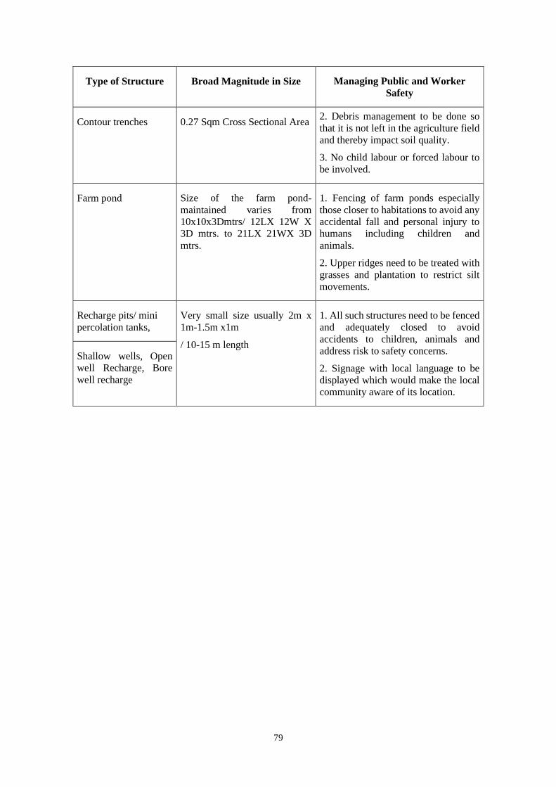
79
Type of Structure Broad Magnitude in Size Managing Public and Worker
Safety
Contour trenches 0.27 Sqm Cross Sectional Area 2. Debris management to be done so
that it is not left in the agriculture field
and thereby impact soil quality.
3. No child labour or forced labour to
be involved.
Farm pond Size of the farm pond-
maintained varies from
10x10x3Dmtrs/ 12LX 12W X
3D mtrs. to 21LX 21WX 3D
mtrs.
1. Fencing of farm ponds especially
those closer to habitations to avoid any
accidental fall and personal injury to
humans including children and
animals.
2. Upper ridges need to be treated with
grasses and plantation to restrict silt
movements.
Recharge pits/ mini
percolation tanks,
Very small size usually 2m x
1m-1.5m x1m
/ 10-15 m length
1. All such structures need to be fenced
and adequately closed to avoid
accidents to children, animals and
address risk to safety concerns.
2. Signage with local language to be
displayed which would make the local
community aware of its location.
Shallow wells, Open
well Recharge, Bore
well recharge