india meteorological departmentkolli/mol/monsoon/year... · india meteorological department ......
TRANSCRIPT
INDIA METEOROLOGICAL DEPARTMENT
SOUTHWEST MONSOON 2008 END OF SEASON REPORT
HIGHLIGHTS The cumulative seasonal rainfall for the country as a whole was near
normal. Rainfall for the season (1st June to 30th September, 2008) was 98% of its long period average (LPA).
Seasonal rainfall was 107% of its LPA over Northwest India, 96% of its LPA over Central India, 96% of its LPA over south Peninsula and 94 % of its LPA over Northeast India.
Out of 36 meteorological subdivisions, 30 meteorological subdivisions recorded normal rainfall. Only 2 (Punjab and Orissa) and 4 (Nagaland, Manipur, Mizoram & Tripura, West Madhya Pradesh, Vidarbha and Kerala) subdivisions recorded excess and deficient rainfall respectively.
Out of 36 meteorological subdivisions, 92% of the country’s area comprising 32 meteorological subdivisions received excess/normal rainfall and the remaining 8% received deficient rainfall during the season.
Monsoon rainfall was marked by large temporal variations for the country as a whole, as rainfall was 24% above LPA in June and in July it was 17% below LPA. The rainfall was near normal during August and September as it was 3% and 1% below the LPA respectively.
While, there was rapid progress of monsoon over most parts of the country after the onset over Kerala on 31st May, there was delay in withdrawal of monsoon from northwest India. Monsoon covered the entire country on 10th July against its normal date of 15th July. The withdrawal of monsoon from west Rajasthan commenced on 29th
September 2008 against normal date of 1st September. IMD’s long range forecast for the seasonal rainfall over the country as
a whole and over different homogeneous regions except northwest India have been accurate. However, the seasonal rainfall over northwest India and rainfall during July for the country as a whole have not been accurate. While the prediction overestimated the rainfall during July for the country as a whole, it underestimated the seasonal rainfall over northwest India.
2
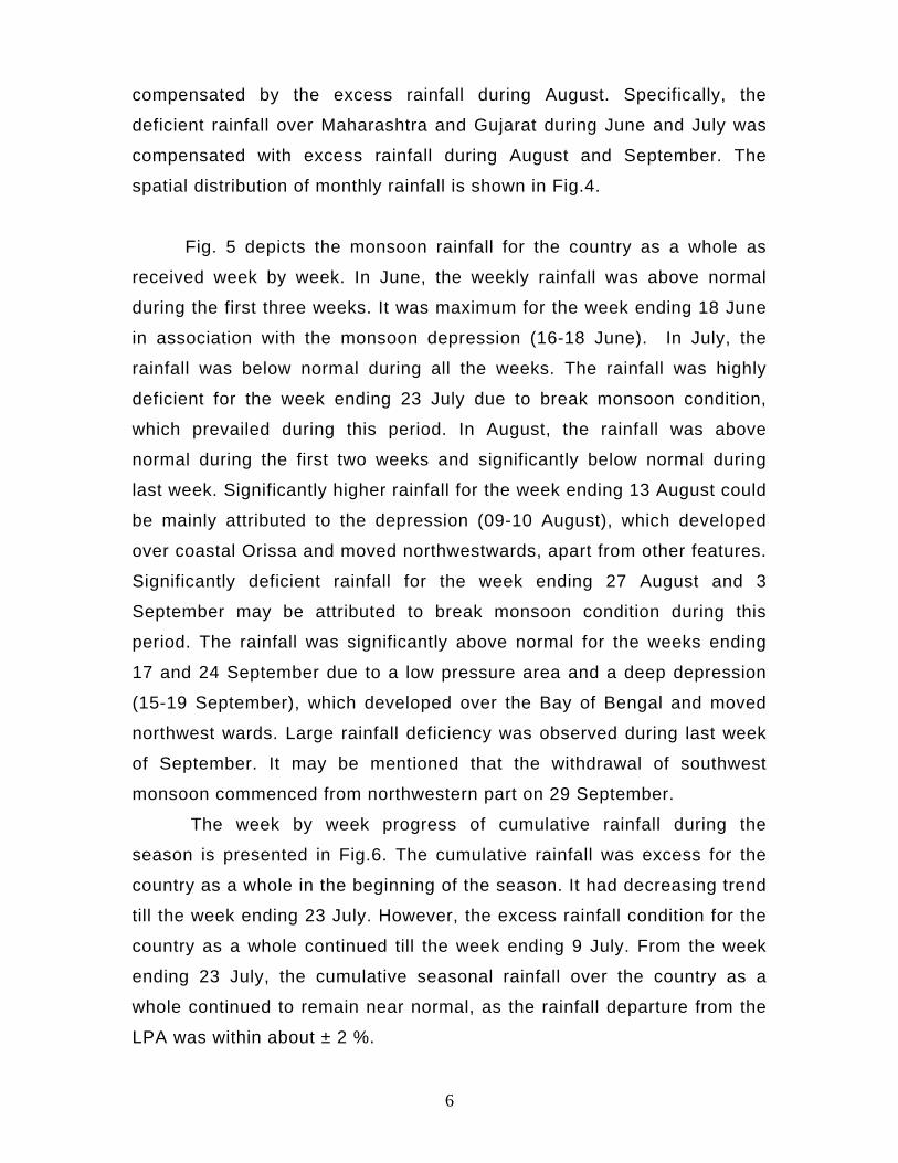
1. ONSET OF SOUTHWEST MONSOON Southwest monsoon advanced over parts of southeast Bay, most parts of
Andaman Sea and Bay Islands on 10 May, 2008, about 5 days ahead of its
normal date (Fig. 1). The monsoon set in over Kerala on 31 May, one day prior to
the normal date. Further, advance took place quite rapidly mainly due to a
depression (5 – 6 June) over the east central Arabian Sea and a well marked low
pressure area (9 – 11 June) over Saurashtra & Kutch and neighbourhood. By
16 June, southwest monsoon had covered most parts of the country except for
some parts of Rajasthan. The rapid advance of monsoon could be attributed to
the interaction of the monsoon circulation with mid-latitude westerly system.
Subsequently, there was a hiatus in the further advance due to the weakening of
the monsoon current. The monsoon covered the entire country by 10 July,
against normal date of 15 July.
2. CHIEF SYNOPTIC FEATURES The mid latitude westerly intrusion, which occurred during advance phase,
resulted into above normal rainfall over most parts of north India (North of Lat.
20o N) during June. The monsoon trough with normal southward tilt with height
could not be active due to the absence of normal large scale north-south
horizontal temperature gradient. The break monsoon conditions also prevailed
over the country during second fortnight of July. It adversely affected the rainfall
over the central and south peninsular India in July.
Compared to last two years, the frequency of monsoon depressions
has been less with development of only four depressions during this
monsoon season. These included one depression over the Arabian Sea and
another over Bay of Bengal during June, one land depression over coastal
Orissa during August and one deep depression over the Bay of Bengal during
September. The tracks of these systems are shown in Fig. 2. The month of July
was devoid of any monsoon depression like the previous July of 1995, 1998,
2000, 2001, 2002 and 2004. However, seven low pressure areas developed
during the season and contributed to the seasonal rainfall.
3
From Fig.2, the depression over the Arabian Sea during 5th to 6th June
moved away westwards and weakened over the Ocean. The second depression
over the Bay of Bengal during 16th to 18th June crossed Bangladesh coast and
moved across Gangetic West Bengal and Jharkhand. It then moved as a low
pressure area upto east Uttar Pradesh and adjoining east Madhya Pradesh. The
system caused heavy to extremely heavy rainfall over Gangetic West Bengal,
north Orissa and Jharkhand leading to flood over these regions. The third
system was a land depression (9 – 10 August) over coastal Orissa and was short
lived with the life period of less than 12 hours. The fourth system was a deep
depression (15–19 September) over the northwest Bay of Bengal which crossed
Orissa coast near Chandbali and moved across north Orissa, north Chhattisgarh,
northeast Madhya Pradesh and central Uttar Pradesh. The remnant low pressure
area moved upto northwest Uttar Pradesh. This system caused heavy to
extremely heavy rainfall over Orissa and Chhattisgarh leading to severe flood
over Orissa. This system also interacted with mid-latitude westerly systems and
caused good rainfall over northwest India and led to flood over Haryana and
Himachal Pradesh.
Apart from the above systems, 7 low pressure areas formed during the
season.
3. FLOOD SITUATIONS The uneven temporal rainfall distribution caused flood situation in many
states viz. Assam, Meghalaya, Arunachal Pradesh, Nagaland, Manipur, Mizoram,
Tripura, West Bengal, Orissa, Bihar, Uttar Pradesh, Haryana, Delhi, Punjab,
Himachal Pradesh, Rajasthan, Gujarat, Maharashtra and Andhra Pradesh.
4. WITHDRAWAL OF SOUTHWEST MONSOON There was a delay in the commencement of withdrawal of southwest
monsoon from extreme west Rajasthan. The southwest monsoon withdrew this
year from entire Jammu & Kashmir, Himachal Pradesh, Punjab, Haryana,
Chandigarh & Delhi, west Rajasthan, most parts of Uttarakhand, west Uttar
Pradesh and east Rajasthan, some parts of north Gujarat State and north
Arabian Sea on 29th September. The normal date of withdrawal of southwest
4
monsoon from west Rajasthan is 1 September. The delay was mainly due to the
presence of systems in westerlies over northwest India interacting with the
monsoon circulation. Comparing with recent years (1990-2007), the latest
withdrawal in recent years from west Rajasthan took place on 30 September
during 2007.
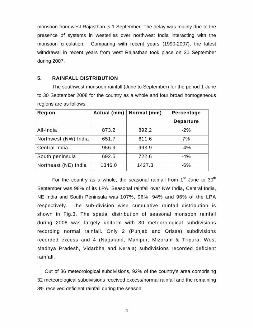
5. RAINFALL DISTRIBUTION The southwest monsoon rainfall (June to September) for the period 1 June
to 30 September 2008 for the country as a whole and four broad homogeneous
regions are as follows
For the country as a whole, the seasonal rainfall from 1st June to 30th
September was 98% of its LPA. Seasonal rainfall over NW India, Central India,
NE India and South Peninsula was 107%, 96%, 94% and 96% of the LPA
respectively. The sub-division wise cumulative rainfall distribution is
shown in Fig.3. The spatial distribution of seasonal monsoon rainfall
during 2008 was largely uniform with 30 meteorological subdivisions
recording normal rainfall. Only 2 (Punjab and Orissa) subdivisions
recorded excess and 4 (Nagaland, Manipur, Mizoram & Tripura, West
Madhya Pradesh, Vidarbha and Kerala) subdivisions recorded deficient
rainfall.
Out of 36 meteorological subdivisions, 92% of the country’s area comprising
32 meteorological subdivisions received excess/normal rainfall and the remaining
8% received deficient rainfall during the season.
Region Actual (mm) Normal (mm) Percentage Departure
All-India 873.2 892.2 -2%
Northwest (NW) India 651.7 611.6 7%
Central India 956.9 993.9 -4%
South peninsula 692.5 722.6 -4%
Northeast (NE) India 1346.0 1427.3 -6%

5
. Thus during the 2008 monsoon season, rainfall activity was near
uniformly distributed in space with most parts of the country receiving near
normal seasonal rainfall.
Monsoon rainfall was marked by large temporal variation. Monsoon
rainfall over the country as a whole was 24% above LPA during June and
17% below LPA in July. It was near normal during August (97% of LPA)
and September (99% of the LPA). The monthly rainfall over India as a
whole is given in the following Table.
Monthly rainfall over the country as a whole during
different monsoon months
Month Actual
rainfall (mm)
Long period
average (mm)
Percentage departure from long
period average
June 201.9 162.2 24
July 243.0 293.3 -17
August 254.3 262.0 -03
September 173.4 174.6 -01
The excess rainfall in June for the country as a whole was mainly
due to the excess rainfall over north and adjoining central India, which
could be attributed to the mid-latitude westerly systems interacting with
the monsoon circulation. The excess rainfall over eastcentral & adjoining
northeast India, Bihar, Jharkhand and West Bengal was mainly associated
with the monsoon depression (16-18 June), which developed over north
Bay of Bengal and moved northwestwards across Bangladesh, Gangetic
West Bengal and Jharkhand. The deficient rainfall in July was mainly due
to the deficient rainfall over central and south peninsular India, excluding
southeast peninsula. At the same time, the rainfall in July was higher
along the foothills of the Himalayas, especially over east Uttar Pradesh,
Bihar and Arunachal Pradesh. This type of rainfall distribution was mainly
due to the break monsoon condition, which developed during 14-24 July.
The deficient rainfall over south peninsular India during June and July was
6
compensated by the excess rainfall during August. Specifically, the
deficient rainfall over Maharashtra and Gujarat during June and July was
compensated with excess rainfall during August and September. The
spatial distribution of monthly rainfall is shown in Fig.4.
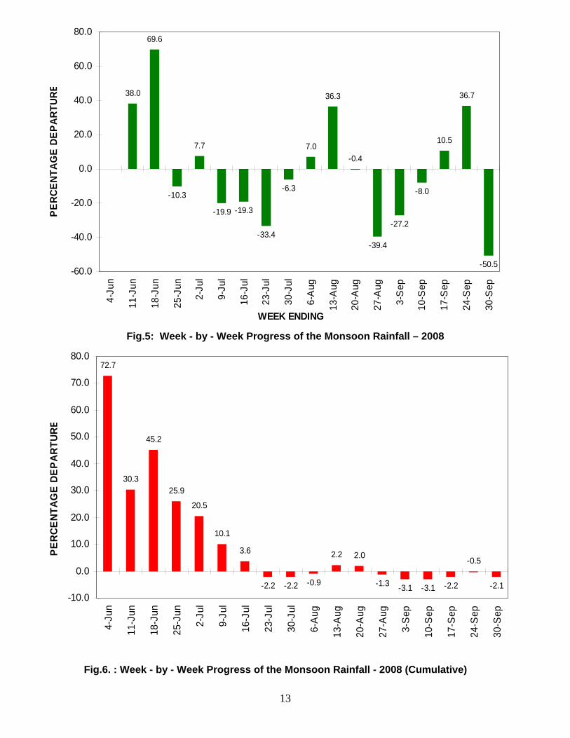
Fig. 5 depicts the monsoon rainfall for the country as a whole as
received week by week. In June, the weekly rainfall was above normal
during the first three weeks. It was maximum for the week ending 18 June
in association with the monsoon depression (16-18 June). In July, the
rainfall was below normal during all the weeks. The rainfall was highly
deficient for the week ending 23 July due to break monsoon condition,
which prevailed during this period. In August, the rainfall was above
normal during the first two weeks and significantly below normal during
last week. Significantly higher rainfall for the week ending 13 August could
be mainly attributed to the depression (09-10 August), which developed
over coastal Orissa and moved northwestwards, apart from other features.
Significantly deficient rainfall for the week ending 27 August and 3
September may be attributed to break monsoon condition during this
period. The rainfall was significantly above normal for the weeks ending
17 and 24 September due to a low pressure area and a deep depression
(15-19 September), which developed over the Bay of Bengal and moved
northwest wards. Large rainfall deficiency was observed during last week
of September. It may be mentioned that the withdrawal of southwest
monsoon commenced from northwestern part on 29 September.
The week by week progress of cumulative rainfall during the
season is presented in Fig.6. The cumulative rainfall was excess for the
country as a whole in the beginning of the season. It had decreasing trend
till the week ending 23 July. However, the excess rainfall condition for the
country as a whole continued till the week ending 9 July. From the week
ending 23 July, the cumulative seasonal rainfall over the country as a
whole continued to remain near normal, as the rainfall departure from the
LPA was within about ± 2 %.

7
6. LONG RANGE FORECAST OF MONSOON RAINFALL
6.1. Onset of monsoon over Kerala: Using an indigenously developed statistical model, IMD predicted
that monsoon onset over Kerala would take place on 29th May with a
model error of ±4days. This year, the monsoon onset over Kerala was on
31st May, just one day earlier than its normal date and hence within the
forecast range.
6.2. Long range forecast of rainfall: The Table below gives the summary of the verification of the long
range forecasts issued for the 2008 Southwest monsoon.
Table: Details of long range forecasts and actual rainfall.
Region Period Issued on Forecast Actual
16 April, 2008 99% of LPA ± 5% All India
June to
September
30 June, 2008 100% of LPA ± 4%
98% of LPA
All India July 30 June, 2008 98% of LPA ± 9% 83% of LPA
Northwest
India 96% of LPA ± 8% 107% of LPA
Northeast
India 101% of LPA ± 8% 94% of LPA
Central India 101% of LPA ± 8% 96% of LPA
South
Peninsula
June to
September 30 June, 2008
98% of LPA ± 8% 96% of LPA
As per the long range forecast for the 2008 Southwest monsoon
seasonal rainfall issued on 16th April, the seasonal rainfall for the country
as a whole was expected to be 99% of LPA with a model error of ± 5%. In
the updated forecast issued on 30th June, the forecast for the country as a
8
whole was revised as 100% of LPA with a model error of ± 4%. The
forecast came correct as the actual area-weighted rainfall for the country
as a whole was 98% of the LPA. IMD had also issued the long range
forecast for July 2008 rainfall over the country as a whole as 98% of its
LPA with a model error of ± 9%. But the actual rainfall in July was 83% of
LPA, much less than the lower limit of the predicted value. Considering 4
broad homogenous regions of India, rainfall was expected to be 96% of its
LPA over NW India, 101% of LPA over Central India, 101% of LPA over
NE India and 98% of LPA over South Peninsula with a model error of
±8%. The actual rainfall over these 4 regions was 107%, 96%, 94% and
96% of the LPA respectively. Thus the long range forecasts for the
seasonal rainfall over all the homogeneous regions except NW India were
accurate. Over NW India the actual seasonal rainfall was slightly more
than the higher limit of the predicted value.
9
Fig.1. : Progress of Southwest Monsoon – 2008

10
Fig.2. : Tracks of the low pressure systems over Indian seas during the Southwest Monsoon Season– 2008

11
Fig.3: Sub-division wise rainfall distribution over India during southwest monsoon season (June to September) – 2008

12
Fig.4: Sub-division wise monthly rainfall distribution over India
during southwest monsoon season – 2008
13
Fig.5: Week - by - Week Progress of the Monsoon Rainfall – 2008
Fig.6. : Week - by - Week Progress of the Monsoon Rainfall - 2008 (Cumulative)
38.0
69.6
-10.3
7.7
-19.9 -19.3
-33.4
-6.3
7.0
36.3
-0.4
-39.4
-27.2
-8.0
10.5
36.7
-50.5-60.0
-40.0
-20.0
0.0
20.0
40.0
60.0
80.0
4-Ju
n
11-J
un
18-J
un
25-J
un
2-Ju
l
9-Ju
l
16-J
ul
23-J
ul
30-J
ul
6-A
ug
13-A
ug
20-A
ug
27-A
ug
3-S
ep
10-S
ep
17-S
ep
24-S
ep
30-S
ep
WEEK ENDING
PER
CEN
TAG
E D
EPA
RTUR
E
72.7
30.3
45.2
25.9
20.5
10.1
3.6
-2.2 -2.2 -0.9
2.2 2.0
-1.3 -3.1 -3.1 -2.2
-0.5
-2.1-10.0
0.0
10.0
20.0
30.0
40.0
50.0
60.0
70.0
80.0
4-Ju
n
11-J
un
18-J
un
25-J
un
2-Ju
l
9-Ju
l
16-J
ul
23-J
ul
30-J
ul
6-A
ug
13-A
ug
20-A
ug
27-A
ug
3-S
ep
10-S
ep
17-S
ep
24-S
ep
30-S
ep
PER
CEN
TAG
E DE
PAR
TUR
E