index properties of soil of sabarmati … properties of soil of sabarmati river, gandhinagar...
TRANSCRIPT
Indian J.Sci.Res. 16 (1): 144-150, 2017 ISSN: 0976-2876 (Print)
ISSN: 2250-0138(Online)
1Corresponding Author
INDEX PROPERTIES OF SOIL OF SABARMATI RIVER, GANDHINAGAR
DISTRICT, GUJARAT
SHUBHAM BHATTa, R.D.SHAH
b, VASU PANCHOLI
c, VINAY DWIVEDI
dAND NISARG
BHATTe1
abM. G. Science Institute, Navrangpura, Ahmedabad,Gujarat,India cdeInstitute of Seismological Research, Gandhinagar,Gujarat.India
ABSTRACT
The present work is mainly focused on the Geotechnical properties of the areas in Gandhinagar district. The
recent growth which is associated with urbanization in Gandhinagar -Ahmedabad Township calls for appropriate
geotechnical investigations of soils of the area. Representative soil samples were collected from the Sabarmati River bed
near Gandhinagar area and were investigated as per Indian standard for their index properties with a view to classifying
for their use in infrastructural development. Mainly all these locations are leading sites of sand mining from where the
soils are supplied as construction material. The soil sample was collected from different locations of the mapped areas in
Gandhinagar district. Samples from each site were collected at 3m depth and analyzed using standard geotechnical test
e.g. Moisture content test (IS: 2720 (PART-2) -1973), Particle size distribution test (IS: 460-1962), Atterberg limit test (IS:
2720 (PART-5) 1985), Specific gravity test (IS: 2720 (PART-3) 1980). Based on the test results obtained from the study
areas, the comparison was made with some standard specifications and it was revealed that samples from all the location
are poorly sorted (uniform size) sand (SP soil) and it can be a good option as a construction material.
KEYWORDS: Geotechnical investigation; poorly sorted sand, Gujarat Alluvium, Sabarmati basin.
The incessant incidence of building failures
is becoming alarming and has led to the loss of life
and assets. These failures have been attributed to
factors such as inadequate information about the
subsurface geological material, poor foundation
design, and poor building materials. (OyedeleKayode
Festus et. al, 2014). The purpose of this paper is to
identify appropriate methods of geotechnical soil
assessment to establish engineering parameters for
geotechnical design. Geotechnical soil parameters
should be based on the results of a complete
geotechnical investigation, which includes in-situ
field-testing and/or a laboratory-testing program,
used separately or in combination. Such investigation
is carried out in order to avert structural failures, as
these failures could lead to disasters which pose
serious threats to public safety. The ultimate goal of
site investigation is to have an appreciable
understanding of the behavior of the soil which will
bear load to be transmitted by the proposed structure.
In the last decade, the involvement of geophysics and
geotechnical methods in civil engineering has
become a promising approach (Adepelumi et al.,
2009; Al Omosh et al., 2008; Schoor, 2002;
Adepelumi and Olorunfemi, 2000). Geotechnical
measurements may greatly improve the quality of
construction in civil engineering as it will focus on
the behavior and performance of soils and rocks in
the design and construction of civil engineering
structures (Oyedele et al., 2009).
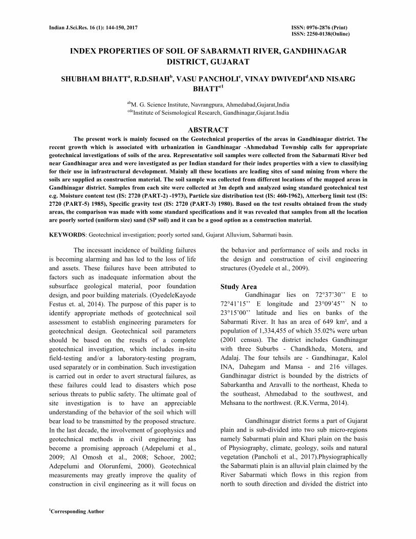
Study Area Gandhinagar lies on 72°37’30’’ E to
72°41’15’’ E longitude and 23°09’45’’ N to
23°15’00’’ latitude and lies on banks of the
Sabarmati River. It has an area of 649 km², and a
population of 1,334,455 of which 35.02% were urban
(2001 census). The district includes Gandhinagar
with three Suburbs - Chandkheda, Motera, and
Adalaj. The four tehsils are - Gandhinagar, Kalol
INA, Dahegam and Mansa - and 216 villages.
Gandhinagar district is bounded by the districts of
Sabarkantha and Aravalli to the northeast, Kheda to
the southeast, Ahmedabad to the southwest, and
Mehsana to the northwest. (R.K.Verma, 2014).
Gandhinagar district forms a part of Gujarat
plain and is sub-divided into two sub micro-regions
namely Sabarmati plain and Khari plain on the basis
of Physiography, climate, geology, soils and natural
vegetation (Pancholi et al., 2017).Physiographically
the Sabarmati plain is an alluvial plain claimed by the
River Sabarmati which flows in this region from
north to south direction and divided the district into
BHATT ET AL:INDEX PROPERTIES OF SOIL OF SABARMATI RIVER, GANDHINAGAR DISTRICT, GUJARAT
Indian J.Sci.Res. 16 (1): 144-150, 2017
two parts(Bhatt et al., 2017).The region has a
maximum height of 75 meters above MSL. The
geology of this region pertains to alluvium, blown
sand, etc. The soils of this region are deep shallow
black, brown and alluvial soils of the northern region.
This region covers the major parts of the district. The
terrain of the Khari plain region is flat alluvial plain
with minor undulations. The geological structure of
this region is formed of alluvium, blown sand, etc.
This region covers Khari River’s catchment area in
the eastern parts of the district.
The River Sabarmati originates at the place
near Vekaria in the Rajasthan state. Thereafter it
touches the borders of three districts in the following
order, viz. Banaskantha, Sabarkantha, and Mehsana.
Subsequently, it enters Gandhinagar district. The
River at present flow from the center of the district.
The River has high banks particularly in its upper
reaches, where they sometimes rise to a height of 60
meters. The River enters this district near the village
Rajpur. Thereafter it traverses near the villages of
Pindarada, Chekhalarni, Piplaj, Dolarana, Vasna,
Pethapur, Lekavada, Indroda, Gandhinagar, Shahpur,
Koba, Valad, Bhat, Motera, Koteshwar, and Chiloda
in this district.
The River Khari is a tributary of the
Sabarmati River. The Khari issues near village
Kesarpura of Himmatnagartaluka of the Sabarkantha
district. Out of its entire length of 160 km the Khari
flows for only 18 km in the Gandhinagar district. It
flows in the south-eastern direction of the
Gandhinagar district.
The Vatrak River rises from the hills of
Dungarpur in Rajasthan. Out of its entire length of
125 km Vatrak flows for only 20 km in the
Gandhinagar district.
Figure 1 SEISMOTECTONIC AND GEOLOGICAL MAP OF
STUDY AREA (after Bhatt et.al 2017)
GEOTECHNICAL INVESTIGATION
A Geotechnical survey is the first step in the
construction or consolidation of a site. It includes
information about soil consistency and structure,
groundwater level and recommendations for the
technical project. The tests required for determination
of engineering properties are generally elaborate and
time-consuming. The properties of soil which are not
the primary interest of geotechnical engineer but
which are indicative of the engineering properties are
called index properties. (Bipulsen et al. 2014)
Physical and engineering properties of
different soil reported that due to the increase of
liquid limit, plasticity index of soil increases and
frictional angle decreases. (Nath and Dalal 2004)
Physical properties of soil may improve the
understanding of soil susceptibility to compaction
and load support capacity.
Grain size analysis is useful for
characterizing a wide variety of physical properties
and affect porosity and permeability, and they are
also related to the geotechnical properties of sediment
(Boggs 1995 and Fetter 2001). Grain size also affects
Atterberg’s limits, bulk density, shear strength,
BHATT ET AL:INDEX PROPERTIES OF SOIL OF SABARMATI RIVER, GANDHINAGAR DISTRICT, GUJARAT
Indian J.Sci.Res. 16 (1): 144-150, 2017
permeability, and pore pressure transients in response
to cyclic loading (Hein 1991). Pal and Ghosh (2010)
studied the influence of physical properties on
Engineering Properties of Fly Ash and concluded that
physical properties have the important effect of the
variation of Optimum Moisture Content, Maximum
Dry Density and hydraulic conductivity of the soil.
Sridharan and Nagaraj (2000), Kaniraj and Havanagi
(2001), Bera et al. (2007) have also estimated the
physical and engineering behavior of different soils.
Terzaghi and Peck (1967) determined the physical
properties of all types of clay and also predicted the
compression index by physical properties of clay.
Nakase et al. (1988) performed large numbers of tests
and estimated constitutive parameters of soil by using
plasticity index. Giasi et al. (2003) studied the index
properties, such as liquid limit and plasticity index of
various soils and proposed numerous equations. Ring
et al. (1962) estimated liquid limit, plastic limit and
plasticity index of soil and they developed two
correlations of compaction characteristics based on
approximate average particle diameter, the content of
particle size finer than 0.001 mm and fineness
average. Seed et al. (1962) have studied the plasticity
index of different soil which is used as a single factor
for predicting swelling potential.
Geotechnical investigation is a tool used to
communicate the site conditions, design and
construction recommendations. Reliability of the
information contained in the geotechnical report has a
strong influence on design, construction, project cost,
safety and resolution of contractual disputes.
Foundation failures are heavily dependent on the
quantity and quality of information obtained from
geotechnical site investigation. (Goldsworthy et al.
2004). The seismic hazard analysis is concerned with
getting an estimate of the strong-motion parameters
at a site for the purpose of earthquake resistant design
or seismic safety assessment. For generalized
applications, seismic hazard analysis can also be used
to prepare macro or micro-zoning maps of an area by
estimating the strong-motion parameters for a closely
spaced grid of sites. (I.D. Gupta 2002) Earthquake
hazard is used to describe the severity of ground
motion at a site (Anderson and Trifunac, 1977,
1978a), regardless of the consequences, while the risk
refers to the consequences (Jordanovski et al., 1991,
1993).
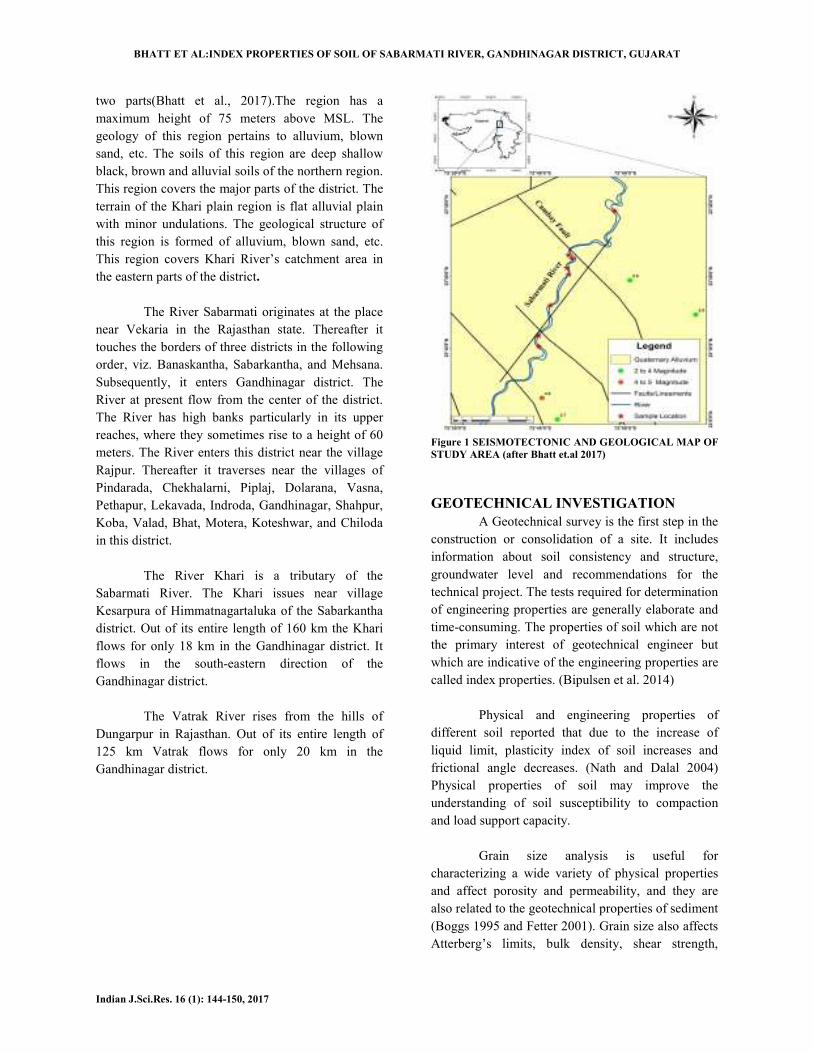
The Geotechnical investigation was carried
out to determine the engineering properties of soil
material within the Alluvium deposits of
Gandhinagar city of Gujarat State, India. Various
index properties are investigated e.g. Grain size
analysis, Consistency of soil (Atterberg‘s test),
Specific gravity, Density, Moisture content
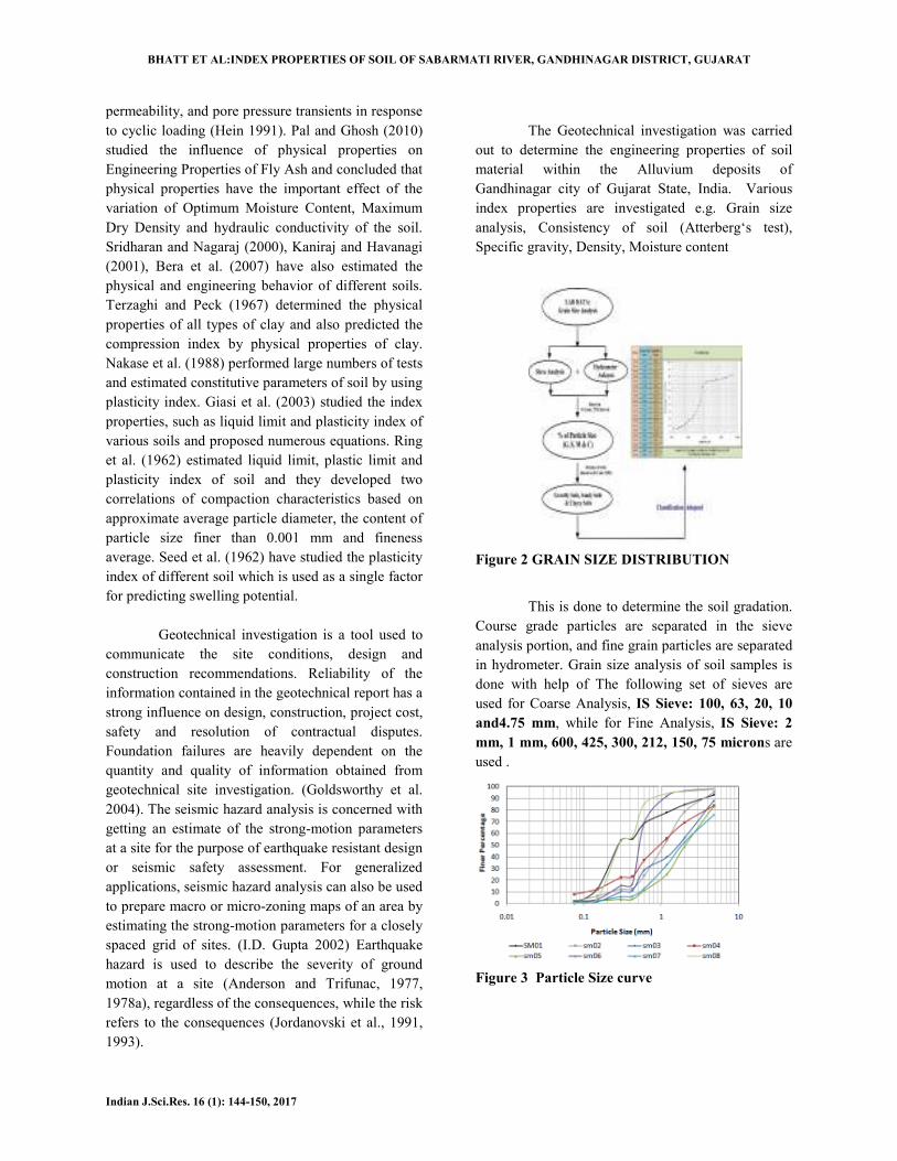
Figure 2 GRAIN SIZE DISTRIBUTION
This is done to determine the soil gradation.
Course grade particles are separated in the sieve
analysis portion, and fine grain particles are separated
in hydrometer. Grain size analysis of soil samples is
done with help of The following set of sieves are
used for Coarse Analysis, IS Sieve: 100, 63, 20, 10
and4.75 mm, while for Fine Analysis, IS Sieve: 2
mm, 1 mm, 600, 425, 300, 212, 150, 75 microns are
used .
Figure 3 Particle Size curve
BHATT ET AL:INDEX PROPERTIES OF SOIL
Indian J.Sci.Res. 16 (1): 144-150, 2017
Atterberg’s Limit
The Atterberg limits define the boundaries
of several states of consistency of plastic soils. The
boundaries are defined by the amount of water a soil
needs to be at one of those boundaries. The
boundaries are called plastic limits and liquid limit,
and the difference between them is called the
plasticity index. The shrinkage limit is also a part of
the Atterberg limits. The result of this test can be
used to help predict other engineering properties
Moisture Content (Wo)
The test provides the moisture content of
soil, from this equation
100*/ 12320 MMMMW −−=
M1 = Mass of container with lid, M2 = Mass of
container with lid and wet soil, M3 = Mass of
container with lid and dry soil
Specific Gravity (G)
The specific gravity of the soil is calculated
with help of following formula. Where, W
of empty bottle, W2 = weight of bottle +soil
weight of bottle +soil +water, W4 = weight of bottle
+water.
Density
The density (ρ) of soil is defined as the mass
(M) of the soil per unit volume (V).From the formula
Where, M= mass of the soil, V = volume of density
bottle. It is expressed in terms of g/cm3
Void ratio & Porosity
The porosity n of a given soil sample is the
ratio of the volume of a void to the total volume of a
given soil mass while void ratio e of a given soil
sample is the ratio of the volume of voids to the
volume of soil solid in the given soil mass.
n = Vv/ V whereVv = volume of void,
volume of soil sample.
e = Vv/ VswhereVv = volume of void,
of soil.
( ) (2 1
4 1 3 2
(W - W
W - W - W -
)
W G =
V
M
ρ =
BHATT ET AL:INDEX PROPERTIES OF SOIL OF SABARMATI RIVER, GANDHINAGAR DISTRICT, GUJARAT
150, 2017
define the boundaries
of several states of consistency of plastic soils. The
boundaries are defined by the amount of water a soil
needs to be at one of those boundaries. The
boundaries are called plastic limits and liquid limit,
them is called the
plasticity index. The shrinkage limit is also a part of
the Atterberg limits. The result of this test can be
used to help predict other engineering properties.
The test provides the moisture content of
soil, from this equation
100 Where,
M1 = Mass of container with lid, M2 = Mass of
container with lid and wet soil, M3 = Mass of
The specific gravity of the soil is calculated
Where, W1 = weight
= weight of bottle +soil, W3 =
= weight of bottle
) of soil is defined as the mass
(M) of the soil per unit volume (V).From the formula
Where, M= mass of the soil, V = volume of density
or kg/m3
of a given soil sample is the
ratio of the volume of a void to the total volume of a
of a given soil
sample is the ratio of the volume of voids to the
volume of soil solid in the given soil mass.
= volume of void, V = Total
= volume of void, Vs = volume
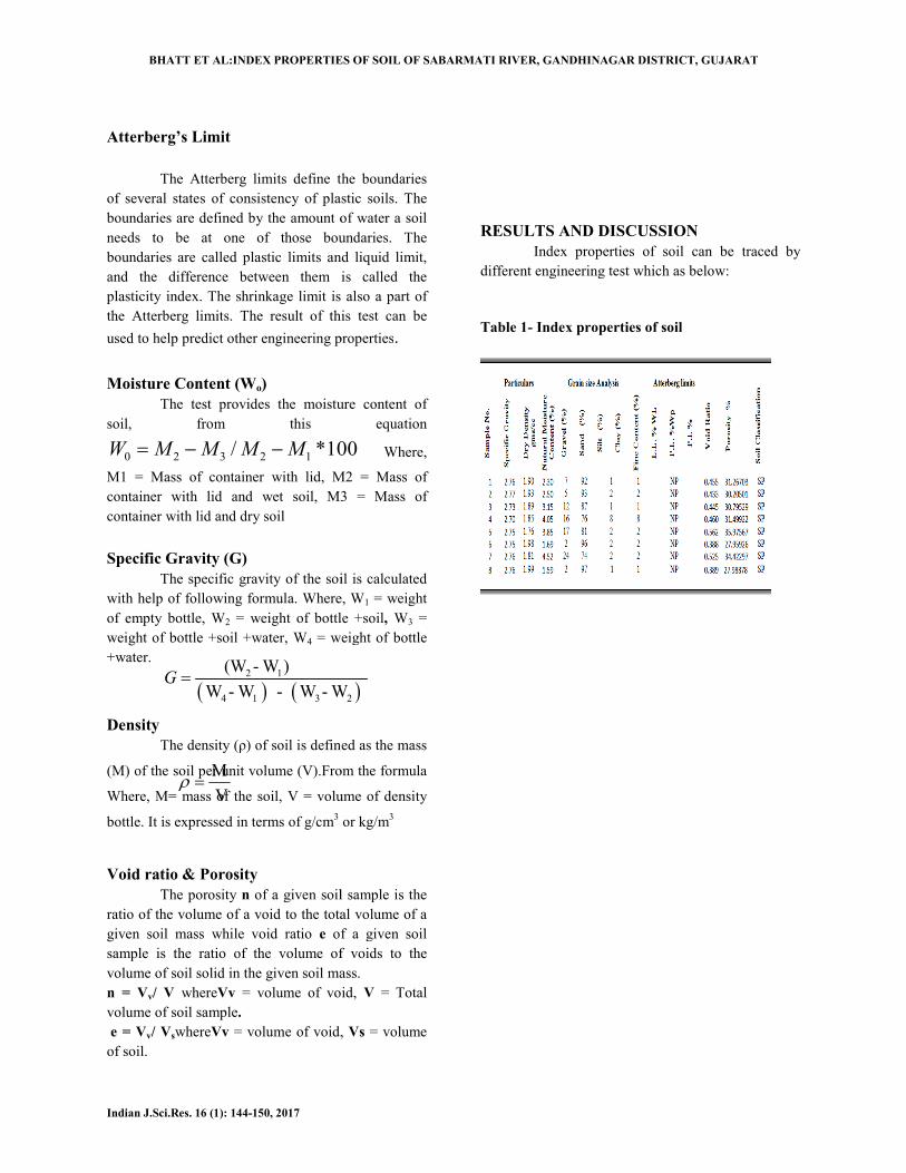
RESULTS AND DISCUSSION
Index properties of soil can be traced by
different engineering test which as below:
Table 1- Index properties of soil
)4 1 3 2
(W - W
W - W - W - W
OF SABARMATI RIVER, GANDHINAGAR DISTRICT, GUJARAT
DISCUSSION
Index properties of soil can be traced by
different engineering test which as below:
Index properties of soil
BHATT ET AL:INDEX PROPERTIES OF SOIL
Indian J.Sci.Res. 16 (1): 144-150, 2017
The result of the mechanical analysis
plotted to get a particle-size distribution curve with
the percentage finer N as the ordinate and the particle
diameter as the abscissa, the diameter is plotted on a
logarithmic scale. The particle –size distribution
curve gives us an idea about the type and gradation of
the soil.
A soil sample may be either well
or poorly graded (uniformly graded). A soil is said to
be well graded when it has a good representation of
particle of all sizes. On the other hand, a soil is said
to be poorly graded if it has an excess of certain
BHATT ET AL:INDEX PROPERTIES OF SOIL OF SABARMATI RIVER, GANDHINAGAR DISTRICT, GUJARAT
150, 2017
The result of the mechanical analysis are
size distribution curve with
percentage finer N as the ordinate and the particle
diameter as the abscissa, the diameter is plotted on a
size distribution
pe and gradation of
A soil sample may be either well-graded soil
or poorly graded (uniformly graded). A soil is said to
be well graded when it has a good representation of
particle of all sizes. On the other hand, a soil is said
ded if it has an excess of certain
particle and deficiency of other, or if it has most of
the particles of about the same. From the particle
distribution curve, we came to know that sample
and sample -08 are of dune sand while all other
samples are of the poorly sorted soil sample.
All the soil samples are SP types which are
poorly graded (uniform particle size) sand
All soil samples are ranging in Specific
Gravity between 2.70 to 2.77 which suggest that
these samples are mainly sandy soil, Dry Density
OF SABARMATI RIVER, GANDHINAGAR DISTRICT, GUJARAT
particle and deficiency of other, or if it has most of
the particles of about the same. From the particle-size
distribution curve, we came to know that sample-06
08 are of dune sand while all other
of the poorly sorted soil sample.
All the soil samples are SP types which are
ed (uniform particle size) sand
All soil samples are ranging in Specific
Gravity between 2.70 to 2.77 which suggest that
these samples are mainly sandy soil, Dry Density
BHATT ET AL:INDEX PROPERTIES OF SOIL OF SABARMATI RIVER, GANDHINAGAR DISTRICT, GUJARAT
Indian J.Sci.Res. 16 (1): 144-150, 2017
ranging from 1.76 to 1.99g/cm3, Moisture content
from 1.69 to 4.05, low Moisture content of soil
suggest that samples are composed sandy soil, Grain
size from 88 to 93 of course grain, due to soil is
composed of mainly course grain Atterberg limits are
NP (not possible), Void ratio ranging from 0.388 to
0.562 and Porosity ranging from 27 % to 35%. All
these properties suggest that soils mainly type of sp
soil, which is called poorly sorted sandy soil.
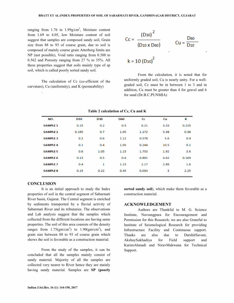
The calculation of Cc (co-efficient of the
curvature), Cu (uniformity), and K (permeability)
.
, ,
From the calculation, it is noted that for
uniformly graded soil, Cu is nearly unity. For a well-
graded soil, Cc must be in between 1 to 3 and in
addition, Cu must be greater than 4 for gravel and 6
for sand (Dr.B.C.PUNMIA)
Table 2 calculation of Cc, Cu and K
CONCLUSION
It is an initial approach to study the Index
properties of soil in the central segment of Sabarmati
River basin, Gujarat. The Central segment is enriched
by sediments transported by a fluvial activity of
Sabarmati River and its tributaries. The observations
and Lab analysis suggest that the samples which
collected from the different locations are having same
properties. The soil of this area consists of the density
ranges from 1.75(gm/cm2) to 1.90(gm/cm
2), and
grain size between 88 to 93 of course grain which
shows the soil is favorable as a construction material.
From the study of the samples, it can be
concluded that all the samples mainly consist of
sandy material. Majority of all the samples are
collected very nearer to River hence they are mainly
having sandy material. Samples are SP (poorly
sorted sandy soil), which make them favorable as a
construction material.
ACKNOWLEDGEMENT
Authors are Thankful to M. G. Science
Institute, Navrangpura for Encouragement and
Permission for this Research; we are also Grateful to
Institute of Seismological Research for providing
Infrastructure Facility and Continuous support.
Thanks are also due to DarshitSavani,
AkshaySukhadiya for Field support and
KarimAhmadi and NiravMakwana for Technical
Support.
BHATT ET AL:INDEX PROPERTIES OF SOIL OF SABARMATI RIVER, GANDHINAGAR DISTRICT, GUJARAT
Indian J.Sci.Res. 16 (1): 144-150, 2017
REFERENCES
Adepelumi AA, Olorunfemi MO.,2000. Engineering
geological and geophysical investigation of
the reclaimed Lekki Peninsula, Lagos,
Southwest Nigeria." Bulletin of
Engineering, Geology and the Environment,:
58: 125-132.
Adepelumi AA, Olorunfemi MO, Falebita DE,
Bayowa, OG. ,2009.Structural mapping of
coastal plain sands using engineering
geophysical technique: Lagos Nigeria Case
Study. Natural Science: 1: 2-9.
BIPUL SEN, DR. SUJIT KUMARPAL.2014.Index
Properties of Soils collected from Different
Locations and Correlations of Parameters."
EDJE,:3443-3445.
Dr.B.C.PUNMIA, ASHOK KUMAR JAIN, ARUN
KUMAR JAIN..2005.SOIL MECHANICS
AND FOUNDATIONS. NEW DELHI:
LAXMI PUBLICATION (P) LTD.
J. S. Goldsworthy, M. B. Jaksa and W. S.
Kaggwa.2004.COSTOF FOUNDATION FA
ILURES DUETO LIMITED SITE
INVESTIGATIONS.International
Conference on Structural andFoundation
Failures, : 398-401.
M.I.TODOROVSKA, L. JORNADOVSKI 2002.
"inverse studies of earthquake source
mechanism from near-field strong motion
records." ISET journal of earthquake
technology: 73-91.
Nath, A. and Dalal, S. S.2004. The role of plasticity
index in predicting compression behavior of
clays." Electronic Journal of Geotechnical
Engineering: 9.
Nisarg H. Bhatt, R. D. Shah. Analysis of
Tectonically controlled Valley Floor
morphology of the Central Segment of
Sabarmati River Basin,2017. An Integral
approach using satellite images and GIS
Techniques. Journal of Indian
Geophysical Union, : 507-515.
Oyedele Kayode Festus, Adeoti, Lukman, Oladele
Sunday and Kamil Akintunde,2014..
"Investigation of a Proposed Four Storey
Building Sites Using Geophysical and
Laboratory Engineering Testing Methods in
Lagos, Nigeria. International Journal of
Scientific Research in Knowledge, : 83-91.
R.K.Verma,2014. GROUND WATER BROCHURE
GANDHINAGAR DISTRICT GUJARAT.
BROCHURE, Ahmedabad: Government of
India Central Ground Water Board West
Central Region,
Vasu Pancholi, Girish Ch Kothyari, Siddharth
Prizomwala, Prabhin Sukumaran, R. D.
Shah, N. Y. Bhatt, Mukesh Chauhan, and
Raj Sunil Kandregula,2017.
Morphotectonic Evolution of
Sabarmati-Cambay basin, Gujarat,
Western India. Journal of Indian
Geophysical Union: 371-386.
IS 2720- (PART II) 1993: Method of test for soil.
IS (460-1962) Determination of particle size
distribution.
IS 2720 (part IV) 1965 Determination of grain size of
soil.
IS (9259-1979) Determination of consistency of soil.
IS 2720 (part V) 1965: determination of liquid and
plastic limit.
IS 2720 (part VII) 1965: determination of moisture
content and dry density.