in-situ communication and labeling of...
TRANSCRIPT
In-Situ Communication and Labeling of Places
Falko Schmid1 and Colin Kuntzsch2
Transregional Collaborative Research Center SFB/TR 8 Spatial Cognition,University of Bremen, P.O. Box 330 440, 28334 Bremen, Germany
[email protected]@informatik.uni-bremen.de
Abstract. An increasing number of applications is based on the conceptof personally meaningful places detected in individual trajectory data.This class of applications will only be accepted if the individual effort oflabeling places is reduced to a minimum and the proposed place labelsare meaningful. To allow for either the automatic generation of placeconcepts and corresponding labels, or the maintenance of a collaborativeplace database, we require better understanding of how people concep-tualize their familiar environments in-situ, thus while being in the place.In this paper we present the results of an in-situ place labeling study.Our results suggest that the harmonization of diverse labels for person-ally meaningful places is possible and the operators for the automaticcomputation of place names are seizable.
1 Introduction
Place is recognized as a central concept in geographic information sciences. Theliterature on place is rich and the history of trying to tackle the essentials ofplace is long. But as soon as we want to operationalize place for applications,we recognize that there are no obvious operators we can use, even the mostbasic concepts are unclear and far from empirical evidence. For computationalpurposes, the literature on place is as unseizable as the concept itself seems tobe in general. Place is usually understood as a conceptual partitioning of space.However, there is nothing like a prototypical place or size of a place, as the par-titioning is applied on many granularities of space, from the earth and beyond toa corner in a room and below. According to Relph (1976), place consists of threecomponents: physical setting, thus the locale of a place, activities performed at aplace and the meanings of a place to the public and the individual. This stressesthe commonsense that place is not just an address or a point drawn on a map- place is always a construct created by the interplay of actual environmentalsetting, individual and public, as well as the experiences and activities estab-lished at the spatial partitioning. This theory is taken a step further towardsoperationalizability by earlier work of Lynch (1960). In his work he identifiedthe structural elements in urban environment that influence the creation of placeconcepts. In the areas of space syntax (see e.g. Hillier & Hanson (1984)) the syn-tactic construction of neighborhoods (which are assumed to cover larger regions

than places (see Cresswell (2004); Agarwal (2004, 2005)) is proposed by Dalton(2007). An individual perspective of place offers Seamon (via Cresswell (2004)).Seamon proposes spatio-temporal construction and anchoring of places by ”ev-eryday movement in space”, i.e. routines or habits that anchor meaning to phys-ical places. Following Seamon, places are the result of movement and activitiesperformed at locations. Although not explicitly investigating place, Hagerstrand(1970) created the foundations of time-geography as a toolkit to analyze spatio-temporal life paths, the containers of individually constructed places. With theincreasing availability of GPS sensors, researchers got more and more interestedin analyzing trajectories according to the spatio-temporal patterns as suggestedby Seamon and Hagerstrand. Especially in the fields of Location Based Servicesthere are many application scenarios grounded in a personal experience of space.Marmasse (1999) propose a place detection to prompt users with location basedTo-Do lists. Ashbrook & Starner (2003) propose a place detection algorithm toforecast future locations based on past place visits. Liao et al. (2007) developeda framework to infer routines from GPS data to support cognitively impairedpersons in public transportation systems. Bicocchi et al. (2007) develops an au-tomated travel diaries. In Schmid & Richter (2006), we developed a fine grainedplace detection algorithm for familiarity estimation for personalized wayfindingassistance (Schmid (2008)). These examples stress the need to detect ”person-ally meaningful places” to create personalized Location Based Services. Theyusually propose that users have to label the detected place accordingly. High-tower (2003) proposes to automatically generate labels for places, as manualapproaches would not scale. Both positions are critical for applications: manuallabeling will under circumstances not scale (as not every possible place will belabeled) and the assigned labels will not be meaningful to everybody. When wehave a look at studies about spatial communication, we can notice the strongdependency from intention, mutual level of familiarity, and context on the choiceof labels. In Weilenmann & Leuchovius (2004) the authors report on a study ofanalyzing mobile phone calls with respect to spatial communication. E.g., to de-scribe their current location, subjects chose different levels of granularities andreferred entities. The particular choice is depends on needs to obfuscate the reallocation or to clarify a location by a personal place of mutual knowledge (e.g. ”Iam home”, ”the place we met last time”). Duckham & Kulik (2005) propose aformal model for place obfuscation for Location Based Services, such a servicerequires transparent meaningful place names if a user needs to control the spatialextends of the obfuscation model. Weilenmann and Leuchovius also noticed, thatsubjects switched the description for the same place or made use of comparablyrough descriptors without problematic consequences.
Zhou et al. (2005a) report about a diary study of subjects keeping track ofthe places they visited. Zhou et al. identified that peoples’ communication prac-tice highly depends on the purpose of communication, the mutual familiarity orthe assumed familiarity with an area, as well as privacy issues. Although thereseems to be good understanding of what a place is and how it can be describedunambiguously on different levels of granularity, other studies show a high indi-

vidual heterogeneity. When ever we use the term heterogeneity in this paper, ithas always to be understood as the selection of different labels for the same or asimilar place 1. In Lovelace et al. (1999) tried to identify which spatial entitiespeople refer to in familiar and unfamiliar routes. An interesting observation ofthis study was the strong heterogeneity of the addressed landmarks across thesubjects. 31 subjects mentioned 119 different landmarks along the unfamiliarroute, but only 16 had been mentioned by 30% or more of the subjects. It isworth to mention that the study took place on a university campus, a highlystructured environment with a usually common spatial vocabulary. This study isa good example for heterogenous naming of spatial entities. 2 People are usuallyable to find a common name for a place, but so far it is unclear which entitiesthey address when they describe a place in-situ (all place studies known to theauthors are ex-situ or do test multiple subjects under the same conditions) andup to which degree this process can be automated.
2 Motivation
Personalized wayfinding assistance (PWA) as introduced by Schmid (2008, 2009)requires place labels to describe routes within a personal frame of reference. PWAis based on a spatial familiarity estimation by analyzing movements of users. Byanalyzing the trajectories with the place detection approach in Schmid & Richter(2006) a spatial user profile, consisting of meaningful places and paths is com-piled. By means of the profile it computes routes along personally meaningfulplaces and paths to generate cognitively ergonomic wayfinding assistance. Inorder to generate meaningful assistance, PWA requires labels (i.e. names) andspatial concepts (e.g. spatial extends, borders, membership functions, etc.) forthe places a user visits and knows. Like in e.g. Marmasse (1999) the user willhave to enter place names up to a certain extend. But to minimize the effortfor the individual, we can either try to automatically generate place labels, aspostulated by Hightower (2003) or we can set up a collaboratively maintaineddatabase for place names. In the first case we could just compute a label as it isrequired, in the latter case previously labeled places can be offered to users vis-iting the same places. Users can then adopt, reuse, or alter a label without muchindividual interaction. However, both solutions require a deeper understandingof place naming under ambiguous conditions and with respect to different gran-ularities. When we generate user profiles with GPS sensors and mobile devices,1 As places are hard to define, the identity relation, thus the identification of the the
same place is most certainly equally hard. We assume a place to be the same place ifthe same label or concept for a place is expressed at a geographically similar positionand has a similar spatial scope.
2 However, this study is not an in-situ study, all names for landmarks have beengathered with photographs or ex-situ, when the subjects have accomplished the giventasks. Ex-situ always incorporates a certain degree of reflection, a process whereplaces are mentally pre-selected according to ”mental” salience. We can assume thatphotographs bias the selection of references, as well as the ex-situ labeling will resultin different results than asking ”Where are you at the moment?”.

we always have to face uncertainty. The usual positioning accuracy of mobiledevices (carried e.g in pockets) are far from unambiguity. I.e., the computedplaces are not necessarily situated at the sensed location and a label would beattached to a wrong place or queried for the wrong position. Furthermore, placesare extended spatial regions, but so far it is unclear how large these regions arein the context of ”personally meaningful places” as required by a number ofapplications. It is further unclear what labels people choose for places in theirfamiliar environment without being in an explicit communication situation. Itis unknown how homogeneous or heterogeneous the set of assigned labels acrossmultiple persons is and if they can be harmonized by a possibly higher-levelconcept of a place.
2.1 Understanding of Place
As indicated in Section 1, places exist on any scale and granularity and the se-lection of a particular concept is highly context dependent. In this paper we con-strain ourselves on places as communicable (urban) units within Location BasedServices requiring the widely used notion of ”personally meaningful places”. In-tuitively, we have an idea what such a place can be. However, computers as thebackbones of Location Based Services need operators and functions to harmo-nize heterogeneous labels for such places, in order to generate labels that aremeaningful for humans, and all this on a granularity which is plausible in thegiven application context (like PWA, diaries, meeting assistants, etc). Only if weknow more about how people conceptualize familiar places while they are in-situ(many scenarios require this condition, either for labeling of places or the loca-tion dependent communication of place knowledge) we can develop applicationsthat simulate this conceptualization and foster the semantic access to spatialinformation.
2.2 Related Work
The aimed granularity is finer than existing approaches of modeling and gener-ating places from available data. Up to the knowledge of the authors, there existno approach for the computation of place names for a dense urban environment.Grothe & Schaab (2008) propose a machine learning approach for the identi-fication of spatial footprints, thus shape approximations, for regions based onavailable Geo-tagged resources. The approach is interesting to identify conceptsof large scale geographic regions. It requires a relatively large amount of taggedmedia and consequently will work well for popular places or regions. However, forall places without tags, the approach will fail. Unfortunately, most places on thegranularity we address will not be tagged (e.g. living areas), whilst other will betagged by plenty of users (e.g. touristic places). Schockaert et al. (2005) proposean automatic method to derive fuzzy spatial footprints by consulting gazetteerswith complex phrases triggering constraint analysis including bordering regions.Twaroch et al. (2008) investigate on the mining of cognitively plausible placenames from social networks to create alternatives in gazetteers. However, these

approaches do not investigate on places that are on the granularity of personallymeaningful places. They are either on the granularity of large geographic regions(e.g. alps), districts within cities, or few very specific (commonly known) places.None of the approaches do consider the in-situ labeling of places and how itrelates to the surrounding environment. Additionally, they to not try to foster abottom-up labeling and concept construction approach. This means it does notguide labeling constructively and is not flanked with additional analysis of theunderlying geographic structures. It is known that spatial structures influencethe conceptualization of space and it is possible to operationalize spatial prop-erties (e.g. Lynch, 1960; Hillier & Hanson, 1984). Dalton (2007) utilizes thesesyntactic properties to automatically compute regions and borders for neigh-borhoods. This is an interesting approach to predetermine spatial regions, alsoon different level of granularities. However, this is a purely syntactic approachwith no link to situated human concepts. We still do not know how people reallyrefer to it and which elements they use to anchor a concept in the environment.A synthesis of both worlds, the syntactic analysis of spatial properties and thesemantic partitioning and labeling seems to be one promising direction to takein the future.
3 The Study
From the perspective of PWA, we are interested in how people refer to placesin-situ in their familiar environment and if similar labels can be automaticallycomputed. However, we could not find evidence on how homogeneous or hetero-geneous the selection and the assignment of names for places are across multiplepersons, the possible spatial extents, and granularities of places. To move a steptowards answering these questions, we set-up an explorative study. The goal ofour study was the examination of following hypotheses:
3.1 Hypotheses
1. The location of a person clearly determines the selection of a place name.2. The labeling of places in familiar environments is homogeneous across people
and it is possible to develop computational models of place on one level ofgranularity (in our case a spatial region of the size of typical positioninguncertainty in dense urban environments).
3. Place labels allow for the computation of semantic higher-level concepts(coarser granularity of a concept of place), which can be utilized in context-aware service configuration and communication.
3.2 Design of the Study
We designed the study to gather place descriptions of subjects being presentwithin a partially familiar environment in order to get insights about where aplace is referred to as a place and in the (forced) case of ambiguous situationswhich place of the possible choices is selected.

Selection of Places We intended to introduce ”undefinedness” of the placesto be labeled. I.e., we wanted the participants not to label a specific entitylike a building, but an area that is plausible in an positioning context of aLocation Based Service application. 3 This allowed us to create ambiguity, withthe intention to force people to select a reference out of multiple choices. Wecovered a range of place classes:
– Places in structured environments: places usually have clear names andfunctions. We covered a large area of the Bremen University campus (regionA in Figure 1).
– Places in less structured environments: places and buildings are notclearly assigned with names or host a well-known functionality. We decidedto cover a part of the ”Technologie Park” (region B in Figure 1). In this areathere are several companies, cafes, restaurants, spin-offs, external researchinstitutes and a museum area.
– Places in natural/unstructured environments: such as places in parksor forests. A forest and recreation area is found in region C in Figure 1.Here we selected places containing either natural features (water bodies),infrastructures (bridges) or recreational objects (playground, horse stable,restaurant).
Fig. 1. The different environments within the covered region: A is the main universitycampus (structured environment), B is a part of the Technologie Park area (semi-structured environment) and C is the recreational area (unstructured environment).
3 The motivation was to simulate positioning uncertainty within urban environments:when a position is estimated by a e.g. a GPS sensor, it always introduces a certainamount of uncertainty (e.g. 50 meters). When a place is now labeled with a position-ing uncertainty of 50 meters, every entity within 50 meters can be the potentiallyreally addressed entity (if we can reduce the label to a single entity at all). If we nowadd the uncertainty to the query as well (a user queries for a place name and haslow positioning quality), the offered place name can be far from the actual locationthe user is currently at.

3.3 Place Communication
The communication of the pre-selected places is problematic: most modalitieseither bias subjects by means of the chosen medium (like an annotated map) ordistract from the main task by applying navigation and positioning tasks. Wedecided not to use an annotated map, as we expected influence on the choiceof labels. Guiding subjects and placing them at a particular location will biasthem to label the pre-selected position.
For these reasons we designed maps without any labels and with no route tofollow. For each subsequent pair of places we designed a map with two regions,one for the current place and one for the next place to navigate to. We did notincorporate a route, as the route would determine a particular approaching of aplace. The density of the places was relatively high, such that there were onlyfew alternatives at all.
Place Visualization We used regions of different shapes and sizes, each ofthem included multiple plausible references. The diameters of the regions rangedfrom 50-100 meters (which is plausible to the positioning uncertainty of low-costGPS sensors). The subjects navigated freely inside the region and selected andlabeled those places they thought the region represents. In the following we willcall these regions place regions.
Fig. 2. Map cutouts from the place navigation map. The left map with the crosses wasthe first version of the place communication, the middle and right map the improvedversion using the place regions as place communicators. The right map contains thesubsequent place of the map in the middle.
Place Visualization Modification In the first three trials we annotated the placewith a cross, but always stated, that this cross was only marking a fuzzy location.The subjects should place themselves somewhere in the area around the crossat a location they thought they could label properly. It turned out, that thisrepresentation strongly determined the choice of labels: subjects tried to positionthemselves as accurate as possible at the location they thought the cross marked

and tried to label this position as exact as possible. This lead to completelyunlikely labels (”the second rightmost lantern in front of XY”’). As this problemcould be clearly observed for all place-marks and across the first three subjects,we decided to alter the map and not to use the three data sets in our analysis.The usage of regions turned out to work as intended: the subjects now navigatedfreely in the region and selected places autonomously.
Place Region Modification We had to modify one place region due to anunexpected construction place: region 7.2 (see Figure 3) had to be altered, asthe old region 7.1 was not accessible anymore.
Fig. 3. All 13 places which had to be labeled.
3.4 Subjects and Procedure
After discarding the data from the first three trials, we ran the study with 10subjects, all were either students of higher semesters or scientific staff. They havebeen familiar with the university campus for three to six years. Both students andstaff had a different background of studies and employment (computer science,law, biology, chemical engineering). The subjects walked the course of approx-imately 3.5 kilometers length in about two hours. The participants walked thecourse of approximately 3.5 km length in about 2 hours. There are variationsas each subject took a slightly different route due to the experimental setup:the subjects carried a folder containing a stack of maps, each illustrating twosubsequent regions (see figure 2). After successful navigation to the illustratedplace region they had to turn the map to see the next map with the next pairof regions. I.e., they always only knew were they have been to and what thenext region would be. They could never optimize their path according to thefuture regions and select places according to that. When our subjects entereda region, they were asked to select the label that would describe the place best
for themselves. They had to place themselves at the position and mark it with aGPS waypoint; the conductor did the same. Each participant was tracked doubly(participant’s GPS, conductor). The participants were equipped with a mobilephone containing a GPS tracking software. The conductor had a dedicated GPSdevice and walked just alongside the subject (estimated distance < 1 meter).
Labeling and GPS Tracking At each place we asked the subjects to answera set of questions verbally. The conductor wrote the answers to files. Answershave never been corrected, no hints or feedback has been given at any point.The questions at every place asked for
– place names (multiple mentions were allowed)– neighboring places in vicinity (multiple mentions were allowed)– judgment of familiarity
After the subject completed the course and labeled all places, they had toanswer a questionnaire containing questions about
– demographic information– the subject of study/profession (determination of familiar area on the cam-
pus)– their usual travel behavior within the regions A, B, C (see Figure 1)– assumed labeling behavior depending on input modality
3.5 Limitations and Scope of the Study
We are aware that one limiting property of the study is the number of subjects,which can be considered as relatively low. However, when we think of labelingin a realistic setting, there will be only few places with a high number of labelsand a large number of places with only very few labels. Insofar, the number ofparticipants reflects something in between.
Another point is the predefinition of our place regions. However a more ”nat-ural” design of partitioning of space requires a large number of participants evenfor very few places. Our study setup allows us to simulate positioning within acertain degree of accuracy at specific locations. As discussed earlier, all of theregions contained entities of different kinds, which also can be expected to resultin according heterogeneous labels for the respective regions.
This study is a place labeling study with the aim to identify the potentialto harmonize heterogeneous place labels for locations which are potentially thesame, similar or neighbored places. From our everyday life we know that peopleuse different names for the same places or the same names for different places.This property causes sometimes some confusion, but is very helpful to talk aboutplaces in terms of regions or groups of entities. This property enables a newparadigm of place communication: moving away from the coordinates/distancebased concept towards a pre-computation of regions and names. These regionscan be addressed by the same label and is still uniquely understandable acrossgroups of persons. However, not much is known about this property so far andwe try to investigate on the first basic results covering this question.

4 Analysis
We received a total of 127 primary in-situ place labels (one is missing due tothe construction place, two due to undetected navigation errors) of 10 subjectsat 13 places. We call the first mention of a label for a place ”primary”, as weassume that this is the label subjects would instinctively use to describe a place(remember that we allowed multiple labels). All in all we received 175 labels ofwhich 60 were unique labels. Of those 60 different labels, 28 have been chosenonly a single time.
4.1 Homogeneity
A computational model of place, thus the automatic generation of place conceptswould ideally identify the commonsense concept of a required place. The sameholds for a bottom-up repository of place labels: only if we overcome coordinatebased labeling and move toward region based labeling, we can find commonidentifiers for places. In this section we analyze the harmonization potential ofdiverse labels within same regions. We compared the number of unique labels ineach region and computed the most common labels for each region as well. Theresults are summarized in Table 1. An overview over the of choice of alternativelabels for place regions is given in Figure 4.
I II III IV
1 7 Unibad (40%) Unibad (60%)2 5 Cartesium (70%) Cartesium (70%)3 3 Haltestelle NW1 (50%) Haltestelle NW1 (75%)4 10 MZH (50%) MZH (50%)5 5 Boulevard (50%) Mensa (60%)
6 7 3* (each 30%) 3* (each 30%)7.1 2 2* (each 50%) 2* (each 50%)7.2 6 MPI (40%) 2* (each 40%)8 9 Wiener/Fahrenheitstr. (40%) Wiener/Fahrenheitstr. (40%)9 4 Universum (100%) Universum (100%)
10 2 Haus am Walde (100%) Haus am Walde (100%)11 4 2* (each 40%) 3* (each 40%)12 5 Uni-See (80%) Uni-See (80%)13 3 2* (40%) Haus am Walde (50%)
Table 1. The table shows the agreement on labels for each region. Column I is theregion number, column II shows the diversity of unique labels from primary and alter-native choices. Column III and IV show the most common label for each region andits relative frequency among primary labels (III) and among all labels (IV). Cells withasterisks show the number of different labels of equal mentions (a complete list of labelswould be too comprehensive). Regions 3 (8 data sets), 7.1 (4 data sets) and 7.2 (5 datasets) differ from the maximum number (10) of data sets per region.

Fig. 4. The distribution of the numbers of chosen labels during single place labelingtasks.
From Table 1 we see the high number of unique place labels for all regions.The average number of unique labels in region C (3.5) strongly differs from thosein regions A (6) and B (5.6), indicating a quantifiable measure for the densityof well-known places in a region. However, every region has either a single mostdominant label or a small set of labels common among subjects. Half of thesubjects (55%) independently selected the same label, even though they couldposition themselves inside the rather coarse place regions, which, in all cases,contained a multitude of plausible entities. Considering this amount increaseseven further to about 60% when we also consider alternative labels. 28 of all 60unique labels were only mentioned once.
4.2 Proximity
To gain insight to the influence of labeling location and the choice of labels,we measured and compared distances between the GPS location (presumablyalready including typical positioning errors of GPS) and the physical boundary(e.g. wall of a building, shore at a lake) of the primary referenced entities as wellas nearby places known to the respective subject (see Section 3.4).
Subjects in most cases placed themselves towards the referred entities. How-ever in most cases subjects did not minimize the distance between the labelinglocation and referenced entity. For each subject and each place region we com-pared the distances of the recorded labeling position for the primary label to thereferred entity with the distances to other places referred to in the secondary(alternative) labels for the place region.
13 of the 127 primary labels referred to entities outside the place regions.As they are not analyzable with respect to the place regions, we excluded themfrom this analysis. We did the same for additional 14 labels, as they referred torather unseizable concepts with no clearly computable boundaries (”South fromthe Kuhgraben heading towards Wiener Strasse”). Among the remaining 100

Fig. 5. The distribution of measured coordinates of labeling locations inside the 13place regions. A positioning behavior towards certain (usually also labeled) entities isobservable.
primary labels only ten labels referred to entities that were more distant thanalternative labels.
4.3 Visibility
Proximity usually implies the visibility of entities. There were only few occasionswhere referred entities were not visible at all from the respective points of view.In region 6 three subjects referred to the central university cafeteria (which itselfproved very important among subjects), while they at the same did not name alarge visible building (Studentenwohnheim) which would be assumed as highlysalient by a usual classification.
4.4 Saliency
For each region we classified spatial entities according to saliency (base area andheight, as available from our geo-data). Other spatial features where selectedaccording to their clear out-sticking from the ”background”, e.g. the lake or theplayground in the forest.
Table 2 shows the (classified) most salient entities for each place region,according to computable entities and their properties (size and height) containedin available geo-data at the time of the analysis. The symbol > expresses ”moresalient than” relation between two given entities A and B (based on valuesof height h and the base area b) Entities located outside a place region aremarked with a single asterisk. Entities on a granularity below building level wereexcluded from this view, as well as the large region-type entities. All referencesnot explicitly listed are summarized as ”others”.
The results listed in Table 2 show that the correlation between saliency andthe actually labeled entity is in some regions low. Even when we expand the

region ID order of saliency & rate of reference
1 Sportturm (30%) > Unibad (40%) > others (30%)2 MZH (10%) > GW2 (10%), VWG (10%) >
Cartesium (60%), SFG (0%) > others (10%)3 MZH* (0%) > NW1 (0%) > others (100%)4 MZH (50%) > Glashalle (10%) > others (40%)5 Studentenwohnheim (0%) > NW1 (0%) > Library (0%) >
Glashalle (0%) > Mensa (40%) > others (60%)
6 ZHG (20%) > others (80%)7.1 MZH* (50%) > Mensa (0%) > others (50%)7.2 MPI (40%) > others (60%)8** others (100%)9 Universum (100%) > Chocoladium (0%) > GW1 (0%) > others (0%)
10 Haus am Walde (100%) > others (0%)11 Pavillon* (30%) > Stadtwaldsee (20%) > others (50%)12 Uni-See (80%) > Spielplatz (10%) > others (10%)13 Haus am Walde (40%) > Reiterhof (40%) > others (20%)
Table 2. An overview over salient spatial entities, ordered by the saliency. The ratioof the primary labels at the respective place regions are listed in brackets.
observation to the next salient entities, the number of references to not saliententities still can be considered as high. There are even examples where the mostsalient, clearly visible entities have been entirely ignored by all subjects. Figure6 shows the ratio of the selection of salient/non-salient entities for place labels.The selection of salient entities correlates with the self-reported familiarity: Thenumber of references to the most salient entity in each region increased as indi-vidual familiarity with the predefined regions decreased. Personal experience or”social saliency” seems to be dominant factors in-situ labeling.
4.5 Label Granularity
The dominant labeled entities were buildings (54,3% of all in-situ-labels). Thereason for the selection of buildings as labels is possibly due to the respectivelystructured environment of a campus, but clearly can be observed in the othertwo regions as well. This observation raises the question, if the situated concep-tualization of place in urban environments is equivalent to buildings. Of coursethis is not the general case and we observed different classes of labels:
– Sub-Building-Level: a label refers to a functional/logic unit inside a build-ing (a company inside a bureau building, a cafeteria inside a building). 7 ofthe primary 127 (5,5%) labels can be assigned to this granularity.
– Building-Level: a label refers to an entire building without addressing finerstructures. This was the dominant granularity for self-reported well-knownregions. 69 labels directly referred to buildings (54,3%).
– Transportation: 9 (7,1%) labels referred to nodes of public transportation(bus and tram stations).
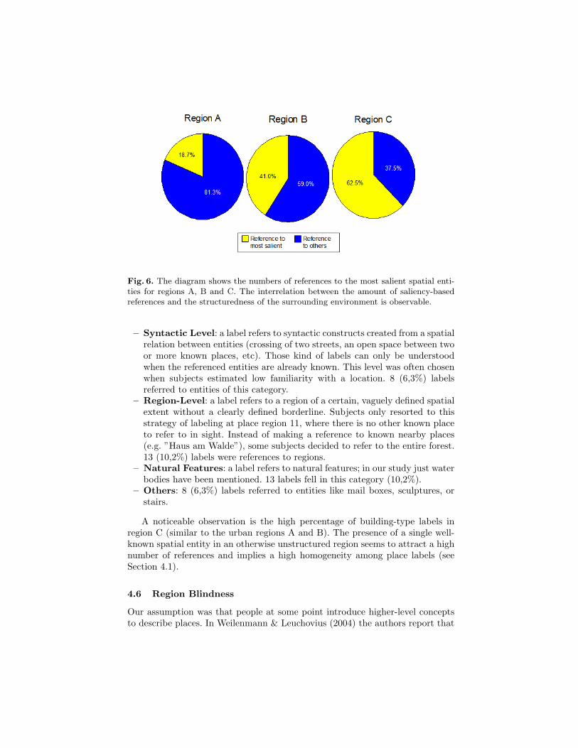
Fig. 6. The diagram shows the numbers of references to the most salient spatial enti-ties for regions A, B and C. The interrelation between the amount of saliency-basedreferences and the structuredness of the surrounding environment is observable.
– Syntactic Level: a label refers to syntactic constructs created from a spatialrelation between entities (crossing of two streets, an open space between twoor more known places, etc). Those kind of labels can only be understoodwhen the referenced entities are already known. This level was often chosenwhen subjects estimated low familiarity with a location. 8 (6,3%) labelsreferred to entities of this category.
– Region-Level: a label refers to a region of a certain, vaguely defined spatialextent without a clearly defined borderline. Subjects only resorted to thisstrategy of labeling at place region 11, where there is no other known placeto refer to in sight. Instead of making a reference to known nearby places(e.g. ”Haus am Walde”), some subjects decided to refer to the entire forest.13 (10,2%) labels were references to regions.
– Natural Features: a label refers to natural features; in our study just waterbodies have been mentioned. 13 labels fell in this category (10,2%).
– Others: 8 (6,3%) labels referred to entities like mail boxes, sculptures, orstairs.
A noticeable observation is the high percentage of building-type labels inregion C (similar to the urban regions A and B). The presence of a single well-known spatial entity in an otherwise unstructured region seems to attract a highnumber of references and implies a high homogeneity among place labels (seeSection 4.1).
4.6 Region Blindness
Our assumption was that people at some point introduce higher-level conceptsto describe places. In Weilenmann & Leuchovius (2004) the authors report that

Fig. 7. The diagram shows the distribution of identified classes of labels. Referencesto buildings are dominant, all other categories are used similarly often.
the selection of spatial granularity was adjusted very flexibly. Especially forrather unfamiliar regions, we expected the choice of labels like ”TechnologiePark”, ”Natural Sciences Part of Campus”, or even ”University”. But our studystrongly suggests that pure in-situ labeling of locations, thus the choice andassignment of a spatial label within the environment, is not the right modalityto gather region based or hierarchical labels. Only at few points of the experimentsubjects chose labels of coarser granularity. Rather the opposite strategy could beobserved. When subjects were in a self-reported unfamiliar region, we observedtwo dominant labeling strategies. The choice of strategy among the subjectswas consistent: every subject used either the strategy of ”place extension” or”syntactic place determination”, no subject mixed those two strategies over theplace regions.
Fig. 8. The diagrams show the distribution of label classes over regions A,B and C. Thesame legend as in Figure 7 is effective. It is noticeable that the amount of referencesto buildings does not vastly differ between the three regions.

– Place Extension: Subjects selected known neighboring places to describethe current place region. The choice of the place was not necessarily drivenby spatial closeness, sometimes producing references to buildings/objects faroutside the current place region (in some cases referencing buildings morethan 100m away from the current location); visibility seems to affect thechoice of the label.
– Syntactic Place Determination: The other group of subjects selectedsyntactic elements from the environment to describe the place (e.g. streetnames at junctions, bus stop names).
There are two exceptions: the entity ”Boulevard” in region A and the ”Stadt-wald” in region C (both in Figure 1. Both exceptions can be explained quitewell: the ”Boulevard” is a strongly connecting network link on the campus. Itis a campus spanning bridge-like construction that connects main facilities ofgeneral university life (Mensa/Cafeteria, library, a shopping and dining facility).It is different from other entities on the campus and seems to be recognized asa self-contained place. The ”Stadtwald” is a forest with the usual undefinednessand lack of unique structuring elements; at many points there is simply no betterway to determine one’s location than referring to the label ”Stadtwald”.
5 Discussion
Our first hypothesis assumes that the labeling location has direct influence onthe choice of the label. It is not surprising that the results in section 4.2 clearlyshow that there is a strong correlation between the position and the choice oflabels, as the referred entity in the majority of cases was the closest entity ofits class. Visibility also has a great impact on the choice of labels. Only in fewcases subjects decided to label occluded entities. 79.8% of all labels referred tothe respectively most proximate entity (see Section 4.2), 97.6% of labels referredto an entity at least partially visible (see Section 4.3). In 77.2% of all labelsboth proximity and visibility were given at the same time. The influence ofsaliency the labels resulted in less clear results, in numerous cases subjects didnot even mention the most salient feature in a region (see Section 4.4). Thiscan be explained by the individual experienec with the environment. Howeverthis finding challenges salience based landmark models (see e.g. Elias (2003);Nothegger et al. (2004); Winter (2003)): cognitive inspired place models are notnecesserily based on visual salience or structural importance, but on individualmeaningfulness of places. This property has clear functional aspects: hub-likeplaces, i.e., places where many people meet temporally (e.g. ”Cafeteria”) seemto be mentally more salient than visually salient entities. I.e., the most salientreference for a certain region might be the entity with the strongest impact onmany people’s daily routines. These results also have impact on the map offeredto a user during labeling: depending on the granularity of concepts and theextents of places we want to gather, the application has to consider the possiblevisibility situation and the established experience of a user. An application will

have to include or highlight plausible entities in the environment to streamlineand harmonize the labeling of place regions.
Our second hypothesis assumes that place names across multiple persons forplaces of the size of ”personally meaningful places” can be harmonized. We findstrong support of this assumption from homogeneity analysis in section 4.1 -subjects are able to identify a number of different labels which sum up to acommon name for a place (for the given region). Just as in the study of Lovelaceet al. (1999), we observed that the number of different primary labels for a placeregion is in some cases high; However, although not the individually first choice,there are always alternative labels which are meaningful to most subjects andfoster the harmonization. We can also observe and support the assumption ofapplications dealing with personally meaningful places: in-situ labels often reflectindividually meaningful concepts. All subjects agreed that they would changethe labeling behavior if the input modality would be constrained. I.e., in anapplication built on user-driven place labels, we can expect a inertial labelingbehavior and as long as users can use previously defined labels for a place. Theapplication itself has either to propose plausible candidates (which we will discussin the next paragraphs), or has to induce the choice of high-level labels that aremeaningful to a potentially larger group of persons. As we have seen from thevisualization problems in the map material (see 3.3- the visualization of placeshas strong influence on the nature of labels. Depending on the kind of labels anapplication requires, it has to initiate and communicate the labeling process.
Our third hypothesis assumed that people will make use of different spatialgranularities to describe a place. However, we observed a preference for entitieswith a clearly identifiable function or name. References to buildings or placesinside buildings made up about 60% of all labels. Only about 10% of the pri-mary labels referred to region concepts often in situations where the region assuch is the only really adressable entity, e.g. the forrest instead of a bunch oftrees. Interestingly, most of the region type labels could have been derived fromexisting geo-data as well (e.g. ”Stadtwald”, ”Wiener Strasse”). Subjects nevermade attemps to disambiguate the location within the region by referring toclose known elements (e.g ”in the forest close to Haus Am Walde”). I.e., in-situlabels in familiar environments do not offer significant possibilities to deductspatial semantic hierarchies. The concept place in the sense of ”I am currentlyhere” seems only to reflect the immediate environment or the closest knownreference, usually on a granularity of clearly distinguishable entities. In an ur-ban environment it is the granularity of buildings (at least for naming places)and sometimes functional units within buildings, in a natural environment likea forest, it is the forest. In contrast to the expectation of our third hypothesis,people tend either to expand entities on the granularity of buildings, or to fallback to elements on a finer level of granularity (street names, junctions). Onlyreflected or ex-situ communication, as verbal communication with other personsor visual communication in form of maps seem to introduce the expression ofregion concepts Weilenmann & Leuchovius (2004); Montello et al. (2003). Whenwe want to retrieve human-centered hierarchical spatial information, we have to

facilitate the expression of them - either by dialogs or by a careful pre-selectionof possible regions. The combination of semantic and syntactic Dalton (2007)approaches is promising: there are clear correlations between the regions an-notated in maps and the structural logic of space syntax. These observationsimply two consequences: We cannot expect semantic higher-level concepts fromsituated labeling. I.e., we have to identify other sources of available informationor have to constructively facilitate the fostering of region concepts. However,spatial entities on the granularity of buildings are obviously suitable and be-havioral valid concepts for places in urban familiar environment. However, thestrong environment dependency also implies that only if we really can assigna name or a function to a building, it is a meaningful reference. In residentialareas where only few buildings with public meanings are present, street sections,natural features and the few public buildings are most likely suitable references(see Section 4.5).
6 Towards a Computational Model of Place
Applications utilizing personally meaningful places benefit from maintaining acollaborative repository of places, or from the automatic computation of placesand places labels. Our study suggests that both cases are implementable. Userscan find homogeneous names for place regions of rather large size (in our case50-100 meters) and the labeling of places is in many cases functionally seiz-able. There are many established methods to compute the isovist-visibility ofentities (see e.g. Batty (2001)) to select visible entities for a specific location(estimation), and computing the most proximate entity is relatively straight-forward. The dominant usage of building labels support straightforward placeinterpretations as postulated in various approaches and the place name studyof Zhou et al. (2005b). Zhou et al. found that people often rely on businessesto describe places, a source which is accessible via business directories. For res-idential areas we can generate labels with respect to rather structural elements(street names or nodes of public transportation). However, our subjects pre-ferred hub-like places to classically visually salient places. The harmonization ofbottom-up place labels can underly the same rationals: we can compute plau-sible areas based on visibility and proximity analysis and attach the labels tothose regions instead of coordinates. The representation of the environment hasgreat influence on the choice of labels and should be applied to foster labelingas required: the proposition of concept borders and commonsense regions but aswell as of semantic regions. We could not observe any indication of introducingregion concepts without map-like representations.
Acknowledgments
We gratefully acknowledge funding granted by the Deutsche Forschungsgemein-schaft (DFG) and the Deutscher Akademischer Austauschdienst (DAAD).

Bibliography
Agarwal, P. (2004). Contested nature of place: Knowledge mapping for resolvingontological distinctions between geographical concepts. In M. J. Egenhofer,C. Freksa, & H. J. Miller (eds.), GIScience, vol. 3234 of Lecture Notes inComputer Science, (pp. 1–21). Springer.
Agarwal, P. (2005). Operationalising ’sense of place’ as a cognitive opera-tor for semantics in place-based ontologies. In A. G. Cohn & D. M. Mark(eds.), COSIT, vol. 3693 of Lecture Notes in Computer Science, (pp. 96–114).Springer.
Ashbrook, D. & Starner, T. (2003). Using gps to learn significant locationsand predict movement across multiple users. Personal Ubiquitous Comput.,7(5):275–286.
Batty, M. (2001). Exploring isovist fields: space and shape in architecturaland urban morphology. Environment and Planning B: Planning and Design,28(1):123–150.
Bicocchi, N., Castelli, G., Mamei, M., Rosi, A., & Zambonelli, F. (2007). Sup-porting location-aware services for mobile users with the whereabouts diary.In MOBILWARE ’08: Proceedings of the 1st international conference on MO-BILe Wireless MiddleWARE, Operating Systems, and Applications, (pp. 1–6).ICST, Brussels, Belgium, Belgium: ICST (Institute for Computer Sciences,Social-Informatics and Telecommunications Engineering).
Cresswell, T. (2004). Place: a short introduction. Wiley-Blackwell.Dalton, N. S. (2007). Is neighbourhood measurable? In Proceedings of the 6th
International Space Syntax Symposium, Istambul.Duckham, M. & Kulik, L. (2005). A formal model of obfuscation and negotiation
for location privacy. In Pervasive, (pp. 152–170).Elias, B. (2003). Extracting landmarks with data mining methods. In COSIT
2003, LNCS 2825, (pp. 398–412). Springer.Grothe, C. & Schaab, J. (2008). An evaluation of kernel density estimation and
support vector machines for automated generation of footprints for impreciseregions from geotags. In W. Stephan, K. Werner, & Krueger (eds.), Interna-tional Workshop on Computational Models of Place PLACE08, (pp. 15–28).Melbourne, Australia: University of Melbourne.
Hagerstrand, T. (1970). What about people in regional sciences? Papers inRegional Sciences, 24:7–24.
Hightower, J. (2003). From position to place. In Proceedings of The 2003 Work-shop on Location-Aware Computing, (pp. 10–12). Part of the 2003 UbiquitousComputing Conference.
Hillier, B. & Hanson, J. (1984). The social logic of space. Cambridge: CambridgeUniversity Press.
Liao, L., Patterson, D. J., Fox, D., & Kautz, H. (2007). Learning and inferringtransportation routines. Artif. Intell., 171(5-6):311–331.

Lovelace, K. L., Hegarty, M., & Montello, D. R. (1999). Elements of good routedirections in familiar and unfamiliar environments. In COSIT ’99: Proceedingsof the International Conference on Spatial Information Theory: Cognitive andComputational Foundations of Geographic Information Science, (pp. 65–82).London, UK: Springer-Verlag.
Lynch, K. (1960). The image of the city. Cambridge: MIT Press.Marmasse, N. (1999). commotion: a context-aware communication system. In
CHI ’99: CHI ’99 extended abstracts on Human factors in computing systems,(pp. 320–321). New York, NY, USA: ACM.
Montello, D., Goodchild, M., Gottsegen, J., & Fohl, P. (2003). Where’s down-town? behavioral methods for determining referents of vague spatial queries.Spatial Cognition and Computation, 3(2):185–204.
Nothegger, C., Winter, S., & Raubal, M. (2004). Computation of the salience offeatures. Spatial Cognition and Computation, 4:113136.
Relph, E. (1976). Place and Placelessness. Routledge Kegan & Paul.Schmid, F. (2008). Knowledge based wayfinding maps for small display cartog-
raphy. Journal of Location Based Services, 2(1):57–83.Schmid, F. (2009). Enhancing the accessibility of maps with personal frames
of reference. In J. A. Jacko (ed.), Proceedings of the 13th International Con-ference on Human-Computer Interaction, Part III: Human-Computer Inter-action. Ambient, Ubiquitous and Intelligent Interaction, vol. 5612 of LectureNotes in Computer Science. Springer; Berlin.
Schmid, F. & Richter, K.-F. (2006). Extracting places from location datastreams. In UbiGIS 2006 - Second International Workshop on UbiquitousGeographical Information Services.
Schockaert, S., De Cock, M., & Kerre, E. E. (2005). Automatic acquisition offuzzy footprints. In On the Move to Meaningful Internet Systems 2005: OTM2005 Workshops, OTM Confederated International Workshops and Posters(SeBGIS 2005), vol. 3762 of LNCS, (pp. 1077–1086).
Twaroch, F. A., Smart, P. D., & Jones, C. B. (2008). Mining the web to detectplace names. In GIR ’08: Proceeding of the 2nd international workshop onGeographic information retrieval, (pp. 43–44). New York, NY, USA: ACM.
Weilenmann, A. H. & Leuchovius, P. (2004). ”i’m waiting where we met lasttime”: exploring everyday positioning practices to inform design. In NordiCHI’04: Proceedings of the third Nordic conference on Human-computer interac-tion, (pp. 33–42). New York, NY, USA: ACM.
Winter, S. (2003). Route adaptive selection of salient features. In W. Kuhn,M. Worboys, & S. Timpf (eds.), COSIT 2003, LNCS 2825, (pp. 349–361).Berlin Heidelberg: Springer-Verlang.
Zhou, C., Ludford, P., Frankowski, D., & Terveen, L. (2005a). An experiment indiscovering personally meaningful places from location data. In CHI ’05: CHI’05 extended abstracts on Human factors in computing systems, (pp. 2029–2032). New York, NY, USA: ACM.
Zhou, C., Ludford, P., Frankowski, D., & Terveen, L. (2005b). Talking aboutplace: An experiment in how people describe places. In In Proc. Pervasive,Short Paper.