in california’s monterey formation siliceous shales …/67531/metadc674691/m2/1/high... · in...
TRANSCRIPT

. , .-
TITLE: ADVANCED RESERVOIR CIQARACTERIZATION IN THE ANTELOPE SHALE TO ESTABLISH THE VIABILITY OF C02 ENHANCED OIL RECOVERY IN CALIFORNIA’S MONTEREY FORMATION SILICEOUS SHALES
Cooperative Agreement No.: DE-FC22-95BC14938
Contractor Name and Address: Chevron U.S.A. Production Company (CPDN) 9 & O l % z-
California Avenue, Bakersfield, California 93309
Date of Report: September 30,1996
.= Q c->-
c 2 d!-3 G c,
qc FGfl z-? p -4
m 5, Award Date: February 7,1996 A -
z x 9
0--, ‘-7 -- c c c
\-
v - vi A. ,-
Anticipated Completion Date: June 1 1, 1998
Government Award for Current Fiscal Year: $2,334,048
Principal Investigator: Stephen C. Smith, CPDN
Project Manager: Edith Allison, Bartlesville Project Office
Reporting Period: July 1,1996 - September 30,1996
Objective
The primary objective of this research is to conduct advanced reservoir characterization and modeling studies in the Antelope Shale reservoir. Characterization studies will be used to determine the technical feasibility of implementing a CO, enhanced oil recovery project in the Antelope Shale in Buena Vista Hills field. The Buena Vista Hills pilot CO, project will demonstrate the economic viability and widespread applicability of CO, flooding in fractured siliceous shales reservoirs of the San Joaquin Valley. The research consists of four primary work processes: Reservoir Matrix and Fluid Characterization; Fracture Characterization; Reservoir Modeling and Simulation; and, CO, Pilot Flood and Evaluation. Work done in these areas is subdivided into two phases or budget periods. The first phase of the project will focus on the application of a variety of advanced reservoir characterization techniques to determine the production characteristics of the Antelope Shale reservoir. Reservoir models based on the results of the characterization work will be used to evaluate how the reservoir will respond to secondary recovery and EOR processes. The second phase of the project will include the implementation and evaluation of an advanced enhanced oil recovery @OR) pilot in the West Dome of the Buena Vista Hills field.
Summary of Technical Progress
The Buena Vista Hills field is located about 25 miles southwest of Bakersfield, in Kern County, California, about two miles north of the city of Taft, and five miles south of

DISCLAIMER
This report was prepared as an account of work sponsored by an agency of the United States Government. Neither the United States Government nor any agency thereof, nor any of their employees, make any warranty, expm or implied, or i~sswnes any legal liabili- ty or responsibility for the accuracy, completeness, or usefulness of any information, appa- ratus, product, or pnwzss disdosed, or represents that its use would not infringe privately owned rights. Reference herein to any specific commercial product, process, or service by trade name, trademark, manufacturer, or otherwise does not neOeSSanly coastitUte or imply its endorsement, recommendation, or favoring by the United States Government or any agency thereof. The views and opinions of authors exprrssed herein do not necessar- ily state or reflect those of the United States Government or any agency thereof.

DISCLAIMER
Portions of this document may be illegible in electronic image products. Images are produced from the best available original dOCUIIlt!llt

the Elk Hills field (Naval Petroleum Reserve No. 1). The Antelope Shale zone was discovered at the Buena Vista Hills field in 1952, and has since been under primary production. Little research was done to improve the completion techniques during the development phase in the 1950s, so most of the wells are completed with about 1000 ft of slotted liner. The proposed pilot consists of four existing producers on 20 acre spacing with a new 10 acre infill well drilled as the pilot CO, injector. Most of the reservoir characterization of the first phase of the project will be performed using data collected in the pilot pattern wells.
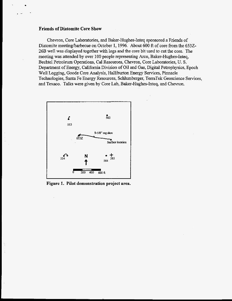
The project took a major step in the third quarter of 1996 with the drilling of the pilot injector well, the Chevron Murvale 6532-26B, Section 26-T3 1 SR23E (Task A.2.). The well spudded on July 1 and was completed on July 29 at a total measured depth of 4907 ft. The well was cored continuously through the entire Brown Shale and the productive portion of the Antelope Shale to just below the P2 e-log marker. The entire cored section was deviated to the west at 20” (see Figure 1).
Reservoir Matrix and Fluid Characterization
Coring Program
The Chevron Murvale 6532-26B well was cored below the 9-5/8” casing shoe fiom 3955 ft to 4907 ft (Task A.2.A), with 99.5% recovery using a Baker-Hughes-Inteq ARC 425 core bit. The 4 in. core was recovered in 4.25 in. inside diameter (id.) fiberglass inner barrel. Once cut, the core was handled to minimize disturbance. The rig crew used a chain to unscrew stands of drill pipe while pulling out of the hole so that the core was not rotated after it was cut. The inner barrel was pulled from the outer barrel in the demck and placed in a core “shuttle”, a piece of casing with a removable cap, for transport to the rig catwalk. Once laid down, the core was pulled from the shuttle with a hand winch onto a horizontal steel rail level with the catwalk. The inner barrel was then cleaned and marked with depth and core and section number and cut into three foot sections. Next, a number of samples were collected at the wellsite for immediate core analyses. Those included anelastic strain recovery (ASR; Task A.3.B.), gas desorption, and wettability (Task A.3.A.). Then the three foot sections were capped, the air inside was displaced with helium, and immediately refrigerated to 34O F and shipped to the laboratory. The core was then scanned for gamma ray spectroscopy and density (Task A.3.C.), laboratory wettability samples taken (Task A.3.A.), slabbed lengthwise into 1/3 (for viewing) and 2/3 (for sampling) sections (Task A.3.D.), and 1 in. plugs cut every foot for Dean Stark cleaning and porosity, permeability, and fluid saturation (PK&S; Task A.3.F.). Profile permeametry was performed on the 1/3 section of core (Task A.3.N.). Composite photographs of the 1/3 core section were taken in white and ultraviolet light and the images were digitized (Task A.3.0.). PK&S samples are still about 1-112 months away from completion. Many of the subsequent core analysis tasks are waiting on completion of the pk&s analysis.
I
Wireiine Logging Program
Over the 9-5/8” cased interval, 803 ft - 3940 ft, Schlumberger ran Platform Express (array induction[AIT], three detector density [TDD], compensated neutron [CNL], micro- cylindrically focused log WCFL], gamma ray [GR], spontaneous potential [SP]). Over the cored interval, 3940 ft - 4907 ft Schlumberger ran Platform Express, Elemental Capture Sonde (ECS), Combinable Magnetic Resonance (CMR), Electromagnetic Propagation Tool (EPT), Accelerator Porosity Sonde (APS), Hostile Natural Gamma-ray Sonde (HNGS), Formation Micro Imager (FMI), Dipole Sonic Imager @SI; p and s mode and anisotropy mode), and Modular Dynamics Tester (MDT; Task A.2.B). Repeat SP passes were made during the log run with an AIT/SP sonde. Due to the low reservoir permeability anticipated, the MDT was run on drill pipe. The resistivity/density/neutron log over the cored interval is displayed in Figure 2.
Preliminary Findings
The slabbed core and FMI image display common small scale fractures, however no major open fracture zones were intersected by the well. The P point to P1 interval appears to contain more sand and is slightly more fractured than the Brown Shale and deeper Antelope Shale. Reservoir wettability measured with wellsite wettability techniques appears mixed or equally oil and water wet, although the Antelope near P2 appears to be more water wet. The SP recorded with the AIT/SP is identical quality to fidl Platform Express SP. Reservoir pressure in the Brown Shale appears to be around 1500 psi, while throughout the Antelope it appears to be about 400 psi.
Fracture Characterization
Prof. Attila Aydin of Stanford University’s Rock Fracture Project has enlisted a new graduate student, Jud Jacobs, to start work on core fracture characterization (Task A.4.E.).
Chris Presmyk, of GeoquestISchlumberger has mapped fractures on the FMI data using Schlumberger’s image examiner workstation (Task A.4.C.). The next step is to break the logged section into structural regimes to bin the data for analysis.
Regional Tectonic Synthesis
The regional structural grain and preferred orientation of most tectonic and physiographic features observed in the southern San Joaquin area are intimately connected with and dominated by the northwest-trending San Andreas Fault system. This is particularly evident in the area west of Bakersfield and surrounding the Buena Vista Hills, where neotectonism continues to exert profound control upon the preferred orientation of most linear structural elements as well as stream and river channels, valleys, and topographic scarps. Some recent investigations in the San Joaquin Basin, which have relied upon various remotely sensed data sets to measure the preferred

orientation of geomorphic features, have observed that these surficial features are consistently oriented approximately N. 40-45' W. North of the San Andreas Fault and N. 55-60' W. south of the fault.
Assuming structural control of all (or nearly all) the physiographic features observed, a rigorous investigation for the tectonic geomorphology of the Buena Vista Hills and the surrounding areas should provide new information regarding the location and age of unobservable (buried) fracture sets and fault displacements in a large oil and gas producing basin. A series of strategically located outcrops could be used to confirm important structural orientation data in areas with abundant measurements acquired from remote sensing analysis. This approach would allow contract participants to rapidly compile regional tectonic data for later kinematic and dynamic analysis. Given the geographic scope of the proposed investigation, Thematic Mapping (TM) imagery and perhaps radar imagery would appear to be the most viable data sets with which to ascertain preferred orientation of surface geomorphic structures. The ATLAS hyperspectral data appears to be best suited for examining outcrop to determine the relationship between fracture density and other fracture attributes at those scales of structural observation.
Advanced Resources International (ARI) has begun to acquire remote sensing data of the Buena Vista Hills area for the regional tectonic analysis (Task A.4.H.). They have received hyperspectral (ATLAS) data acquired by NASA on 10/5/93 and side-looking airborne radar (AIRSAR) data acquired by NASA on 4/4/94. They have purchased TM imagery from the EROS Data Center acquired on 9/15/86. All of the datasets have been copied to compact disks for storage. After processing, the resulting images will be interpreted as part of the preliminary tectonic analysis.
Reservoir Modeling and Simulation
A reservoir engineering database is under construction using a Chevron proprietary database.
Technology Transfer
Siliceous Shale Symposium
Chevron is sponsoring a session on siliceous shale at the 1997 Pacific Section American Association of Petroleum Geologists (AAPG) meeting in Bakersfield. The session is entitled "Reservoir Characterization and Improved Recovery in Siliceous (Monterey-Type) Shales". Abstracts for the session are being solicited from academia, operating companies, and service companies.
r -
Friends of Diatomite Core Show
Chevron, Core Laboratories, and Baker-Hughes-Inteq sponsored a Friends of Diatomite meetinghabecue on October 1,1996. About 600 ft of core from the 6532- 26B well was displayed together with logs and the core bit used to cut the core. The meeting was attended by over 100 people representing Arco, Baker-Hughes-Inteq, Bechtel Petroleum Operations, Cal Resources, Chevron, Core Laboratories, U. S. Department of Energy, California Division of Oil and Gas, Digital Petrophysics, Epoch Well Logging, Goode Core Analysis, Halliburton Energy Services, Pinnacle Technologies, Santa Fe Energy Resources, Schlumberger, TerraTek Geoscience Services, and Texaco. Talks were given by Core Lab, Baker-Hughes-Inteq, and Chevron.
4 553
a 563
cb 554
6K Surface location
* + 385
N 564 t I 0 200 400 600ft
rigure 1. Pilot demonstration project area.

Figure 2. Resistivity/density/neutron log for 6532-26B.