impacts of climate variability and climate change on...
TRANSCRIPT

1
The project proposal on
Impacts of Climate Variability and Climate Change on Water Resources in the Sabarmati River basin
by
Principal Investigator—Vimal Mishra (IIT Gandhinagar)
Co- Investigator – P. L. Patel (SVNIT Surat)
To
Ministry of Water Resources

2
1. Research Institutions:
Name: Civil Engineering, Indian Institute of Technology Gandhinagar, Vishwakarma Government
Engineering College Complex, Chandkheda, Visat- Gandhinagar Highway, Ahmedabad, Gujarat,
India – 382424, Telephone: +91 79 3245 9904
Email: [email protected]
Name: Department of Civil Engineering, Sardar Vallabhbhai Patel National Institute of Technology,
Surat
2. Principal Investigator
Name: Vimal Mishra (IIT Gandhinagar)
Designation: Assistant Professor
Address: Department of Civil Engineering, Indian Institute of Technology Gandhinagar,
Vishwakarma Government Engineering College Complex, Chandkheda, Visat- Gandhinagar
Highway, Ahmedabad, Gujarat, India – 382424, e-mail: [email protected], phone: +91 79 3245
9904
3. Co- Investigator
Name: P. L. Patel
Designation: Professor
Address: Department of Civil Engineering, Sardar Vallabhbhai Patel National Institute of
Technology, Surat, email- [email protected]
4. Brief bio data of the Investigators: Enclosed 5. Project Title: Impacts of Climate Variability and Climate Change on Water Resources of the Sabarmati River basin 6. Track record and work load assessment of the PI Projects undertaken as key personnel 1. NASA, Multisensor/Multiscale Assessment of Urban Impacts in the Great Lakes Region, 2006-2010, Graduate Research Assistant, PI- Laura Bowling

3
2. DOE, Precipitation Extremes in Changing Climate: how much information regional climate model can provide? 2010-2013, key personal, PI- Francina Dominguez and Dennis P. Lettenmaier
3. NOAA, Development of the National Hydrologic Prediction System (NHPS), 2009-2012, key personal, PI- Dennis P. Lettenmaier
4. DOE, Streamflow data assimilation for short-term streamflow forecast, 2010-2013, key personal, PI- Dennis P. Lettenmaier
Proposals Pending: 1. Hydro-meteorological Extremes over the Indian Monsoon Region: Climatology, Synthesis, Cybertools, and Products (Co-PI, submitted to Information Technology Research Academy) 2. Measurement to Management (M2M): Improved Water Use Efficiency and Agricultural Productivity through Experimental Sensor Network (Co-PI, submitted to Information Technology Research Academy) 3. Impacts of climate change on water resources of the Godawari basin (Co-PI, submitted to Ministry of Water Resources)
Ongoing Projects: None 7. If the scheme is sanctioned, in whose name the cheque is to be issued: Assistant Registrar, IIT Gandhinagar
8. Category of R&D Activity (Tick those which are appropriate):
a. Basic Research
b. Applied Research√
c. Action Research
d. Education and Training
e. Mass Awareness Programme
f. Infrastructure Development
g. Creation of Centres of Excellence

4
9. Description of the proposal Proposal Summary
Climate variability and climate change has posed tremendous pressure on Indian water resources. The monsoon rainfall variability during the last few decades suggests a decline in rainfall totals (Mishra et al., 2012a). On the other hand, temperature over India has been rising substantially during the last few decades, which is consistent with the trends in global mean temperatures. Climate warming with erratic monsoon rainfalls resulted in significant variability in water availability and water storage across India and specifically in the western parts of the country. Food and fresh water security remains one of the greatest challenges that India faces in the era of climate change. Moreover, demands for fresh water are likely to increase under the projected climate change scenario due to following reasons: i) warming climate may lead to accelerated water cycle with more losses to atmosphere through evaporation and evapotranspiration, ii) during the recent years, monsoon season rainfall has been more erratic leading to some major drought events, iii) surface and sub-surface water storage may be short-lived under the climate change scenario if weaker monsoon rainfall and elevated air temperatures occur in India, and iv) increasing demand of food production will further pose challenges to Indian water resources.
Despite the several implications of climate change on water resources, efforts have been limited to study the nature and variability of changes at the regional or watershed scale. In this proposal, we intend to develop an integrated framework using the suit of hydrologic models that will be provided the input of high resolution downscaled and bias corrected climate change scenarios from multiple CMIP 5 models for the Sabarmati River basin. Our modeling framework will include the Variable Infiltration Capacity (VIC), Soil and Water Assessment Tool (SWAT) HEC-RAS and HEC-HMS models which will assess changes in water resources under the retrospective and projected future climates. Moreover, we will use wide range of climate and hydrologic indices to understand the impacts due to changes in mean as well as extreme climate. For instance, the impacts of climate variability and climate change will be assessed on the frequency and variability of droughts, floods, heat waves, and floodplain extents across the Sabarmati River basin. Our proposed work will answer following questions:
1) How have hydrologic conditions associated with soil moisture, evapotranspiration, surface and subsurface runoff, groundwater levels, and streamflow changed during the last 50 years in the Sabarmati River Basin (SRB)?
2) How will water availability and water storage vary with space and time under the projected future climate change in the SRB?
3) How have hydrologic extremes changed during the last 50 years and how these are likely to change during the projected future climate in the SRB?
4) To what extent changes in water storage, water availability, and hydrologic extremes will influence agricultural production, reservoir operation, urban flooding, and flood management?

5
1. Introduction Adequate water availability is vital for human society and development. Increasing population along with climate variability and change is expected to impact water availability for storage and supply, which in turn will pose challenges to global fresh water security (Vorosmarty et al., 2000). Vorosmarty et al. (2010) reported that nearly 80 % of global population is exposed to a high level of threat to water security (Fig. 1). Agricultural regions are especially vulnerable
for fresh water insecurity as agriculture water use accounts for about 70% of total water that is withdrawn from surface and groundwater resources (Wisser et al., 2008). Furthermore, irrigation is the most important water use sector accounting for about 70% of global fresh water withdrawals and 90% of the consumptive water use (Siebert et al., 2010).
Impacts of climate variability and change are visible in various sectors (water availability, water storage, extreme hydrologic events) across the regions and nations in the globe. Huntington (2006) provided evidences of intensification of the global water cycle that could lead to changes in the water resources availability, frequency and intensity of hydrologic extremes (drought and floods), and amplification in climate warming through water vapor feedback. Climate Change may pose serious implications for water availability. For instance, Immerzeel et al. (2010) reported that climate change will reduce the melt water availability from glaciers thus affecting the Asian water towers. They found that Brahmaputra and Indus basins are the most susceptible to reduction of flow under the projected climate change, which in turn will threaten the food security in these basins. Dai et al. (2008) conducted analysis on fresh water discharge from many global rivers and reported that the number of rivers with declines in freshwater outnumbered those that showed increases indicating that water availability may be a serious issue under the projected climate change. Arora and Boer (2001) found that under the climate warming scenario there is a general decrease in runoff, mean annual flow, annual flood magnitudes in many rivers with a greater spatial variability, however.
Climate extremes are expected to become more pronounced under the projected climate change (Easterling et al., 2000). Changes in hydrologic extremes have been noted at global scale with substantial variability in occurrences of droughts and floods (Higgins et al., 2000; Dai et al., 1998). For instance, Sheffield and Wood (2008) reported huge variability in drought occurrences, their durations, and areal extent in many regions. Among the natural disasters, the economic and environmental implications of droughts are highest due to wide areal extent and persistence (Wilhite et al., 2000), which may further increase under the changing climate conditions. Floods are also likely to increase under the projected climate. Milly et al. (2002) reported that frequency of great floods has increased substantially in the 20th century and significant positive trends in great floods are consistent with the climate model projections.
Extreme precipitation events often cause flooding and landslides, which in turn result in loss of life and economic damage. Both observational (Allen et al., 2002; Lenderink and van Meijgaard, 2008; Min et al., 2011; Mishra et al., 2012) and simulations (Kharin et al., 2007; Gutowski et al., 2007; Meehl et al., 2000) suggest that precipitation extremes increase as the atmosphere warms. Min et al. (2011) showed that human-induced increases in greenhouse gases contribute to the observed intensification of heavy precipitation events over the majority of the Northern Hemisphere’s land areas.
Fig 1. Global geography of incident threat to human water security. Figure from Vorosmarty et al., 2010.

6
Climate variability and climate change have substantially affected water resources and agricultural production in India. Gossian et al. (2006) found that under the climate warming scenario, severity of droughts and intensity of floods can get deteriorated in many parts of the region. Most of the studies based on general circulation model (GCMs) suggest that India will face warmer and wetter conditions under the projected climate change if there is an increase in the intensity of monsoon season rainfall (Kumar et al., 2005). Kumar et al. (2011) reported that air temperatures in India during the late 21st century will very likely exceed the highest values experienced in the 130-year instrumental record. They further found that changes in the monsoon climate could increase human and crop mortality posing a socioeconomic threats in India. Furthermore, climate change is expected to alter the vulnerability profile of India (O’Brien et al., 2004). O’Brien et al. (2004) reported that the states located in the western parts of India will be highly vulnerable to the implications of climate change (Fig. 2).
Impacts of historic climate variability and projected future climate change on hydrologic processes and water resources may have large spatial and temporal variations. For instance, soil moisture, runoff, and evapotranspiration can vary greatly within the watershed affecting the dynamics associated with the streamflow generation. So far, efforts to understand climate change impacts on water resources have largely been devoted to national scale. Regional scale impact studies may provide better understanding of the impacts associated with climate change and their socioeconomic implications. Despite the previous studies that have been mostly devoted on larger spatial scales, our understanding on impacts of climate variability and climate change on watershed scale is still limited due to following major reasons: i) lack of approaches involved with the downscaling of climate model projections, ii) lack of climate projections from multiple models, iii) lack of physically based hydrologic modeling system that can solve water and energy balance at the grid scale, iv) lack of understanding on uncertainty in climate model projections and its propagation to hydrologic modeling system, v) lack of comprehensive assessment of climate change implications on wide range of areas such as water resources, agriculture, urban flooding, and reservoir operations. Here, we propose to evaluate impacts of climate variability and climate change in the Sabarmati River basin using the downscaled climate
Fig.2 District-level mapping of climate change vulnerability, Measured as a composite of adaptive capacity and climate sensitivity under exposure to climate change. Districts are ranked and presented as quantiles (from O’ Brien et al., 2004).
Fig.3 The Sabarmati River basin and location of dams (source: Water Resources Information System of India)air temperature (deg.
7
projections from multiple models and the physically based hydrologic modeling system.
2. Background and Science Questions
The Sabarmati River basin is one of the major west flowing river of Gujarat that originates from Dhebar lake in Rajsthan and meets the Gulf of Cambay of the Arabian Sea. The total catchment area of the basin is 21,674 km2 that is shared by Rajasthan and Gujarat States. The Sabarmati basin has maximum length of 317 km. In the east of the Sabarmati River basin the Banas and Mahi basins are located, in the north the Luni basin is located, while its southern boundary borders with Gujarat. The average annual rainfall in the Sabarmati river basin is about 750 mm. Annual renewable water resources are about 3810 million m3. Approximately 75 % of the area in the SRB is under agriculture, while about 4% is covered by water bodies. Out of 1.5 million hectare,1.13 million ha is irrigated either by surface or groundwater resources. The average annual flow in the Sabarmati River basin is 3.81 km3 out of which 1.93 km3 is usable (Kumar et al. 2005). Wheat, maize, and groundnut are the major crops in the basin that receive most of the water through irrigation. Dharoi dam is located in the northern part of the Sabarmati River basin. Catchment area of the sub basin is 5,540 km2, out of which about 2,640 km2 lies in Gujarat state.
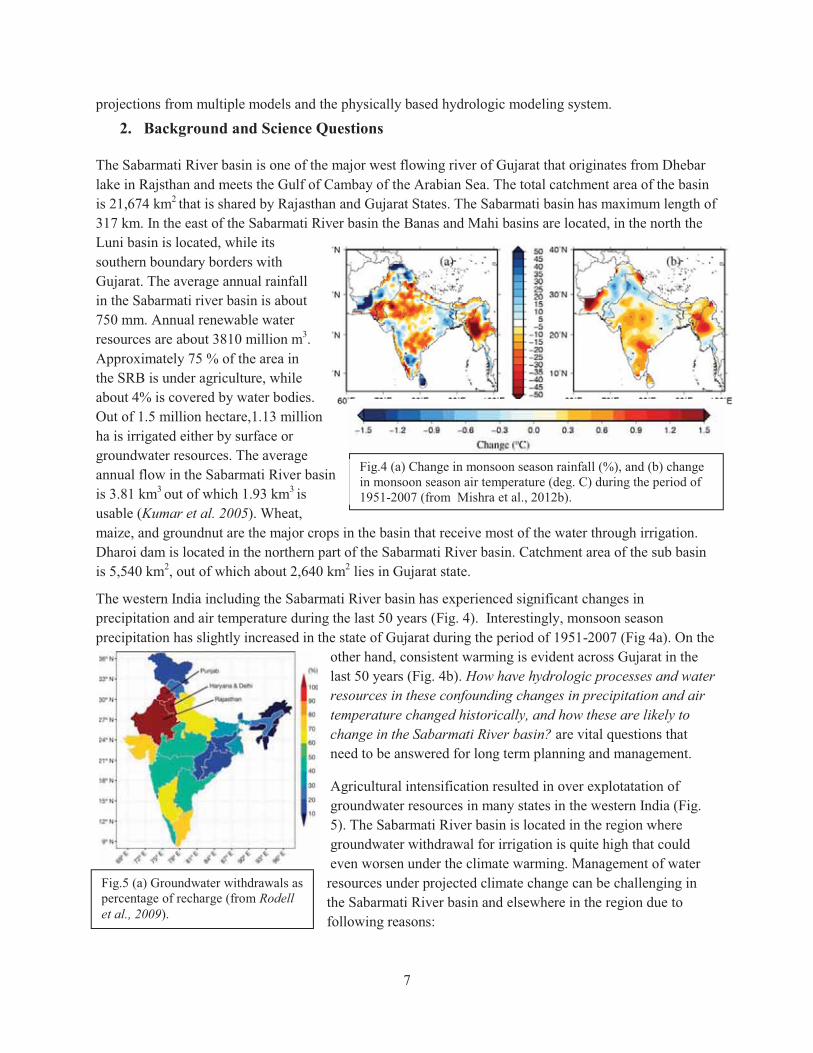
The western India including the Sabarmati River basin has experienced significant changes in precipitation and air temperature during the last 50 years (Fig. 4). Interestingly, monsoon season precipitation has slightly increased in the state of Gujarat during the period of 1951-2007 (Fig 4a). On the
other hand, consistent warming is evident across Gujarat in the last 50 years (Fig. 4b). How have hydrologic processes and water resources in these confounding changes in precipitation and air temperature changed historically, and how these are likely to change in the Sabarmati River basin? are vital questions that need to be answered for long term planning and management.
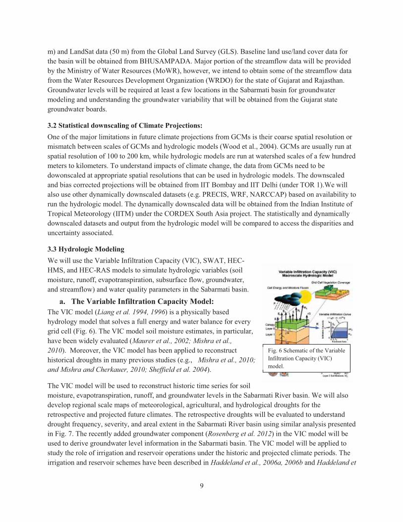
Agricultural intensification resulted in over explotatation of groundwater resources in many states in the western India (Fig. 5). The Sabarmati River basin is located in the region where groundwater withdrawal for irrigation is quite high that could even worsen under the climate warming. Management of water resources under projected climate change can be challenging in the Sabarmati River basin and elsewhere in the region due to following reasons:
Fig.4 (a) Change in monsoon season rainfall (%), and (b) change in monsoon season air temperature (deg. C) during the period of 1951-2007 (from Mishra et al., 2012b).
Fig.5 (a) Groundwater withdrawals as percentage of recharge (from Rodell et al., 2009).

8
� Increased climate warming will lead to more losses through evaporation and evapotranspiration, which in turn will increase irrigation frequency for multiple crops and seasons (Barnett et al., 2005; Schlenker et al., 2007);
� During the recent years, climate has become somewhat more erratic leading to frequent droughts in India (Mishra et al., 2012a; Ramanathan et al., 2005);
� Surface water storage in ponds and reservoirs may become short-lived under climate change and enhanced hydrologic cycle (Tanaka et al., 2006; Barnett et al., 2005), and;
� Indian population is growing while potential area that can be used for agriculture is shrinking (Milesi et al., 2010).
Hydrologic changes in the Sabarmati river basin are driven by changes in mean and extreme climate (precipitation and temperature). Variability associated with the monsoon season rainfall during the recent decades with the frequent extreme events highlight risks and vulnerability associated to water resources management. The proposed work will address the following science questions:
5) How have hydrologic conditions associated with soil moisture, evapotranspiration, surface and subsurface runoff, groundwater levels, and streamflow changed during the last 50 years in the Sabarmati River Basin (SRB)?
6) How will water availability and water storage vary with space and time under the projected future climate change in the SRB?
7) How have hydrologic extremes changed during the last 50 years and how these are likely to evolve during the projected future climate in the SRB?
8) To what extent changes in water storage and water availability, and hydrologic extremes will influence agricultural production, reservoir operation, urban flooding, and flood management?
3. Approach
Our approach for the proposed work will have four major components: (i) development of hydrologic modeling framework for the Sabarmati River basin, (ii) diagnose changes and variability in hydrologic extremes during the retrospective climate (1950-2008), , (iii) understating changes and variability in hydrologic process and hydroclimatic extremes using the multi-model downscaled climate projections and the hydrologic modeling framework, and (iv) evaluation of implications of projected climate change on water resources, agricultural production, reservoir operation, water quality urban flooding, and hydroclimatic extremes under the consideration of associated uncertainty.
3.1 Data Collection We will make extensive efforts on collecting data related climate and meteorological forcings, soil and vegetation, land use and land cover, groundwater, streamflow, and cropping patterns in the Sabarmati River basin. Observed climate data will be collected from observation stations and other sources that provide gridded datasets at various resolution (e.g. Indian Meteorological Department (IMD), Sheffield et al. (2006), and APHRODITE). The soil data will be obtained from the Food and Agriculture Organization (FAO)–United Nations Educational, Scientific and Cultural Organization (UNESCO) digital soil map of the world with the World Inventory of Soil Emission Potentials (WISE) and from the All India Soil and Land Use Survey (AISLUS).Vegetation data will be taken from the University of Maryland’s 1 km vegetation class dataset (Hansen 2006). Moreover, to assess recent changes in land use / land cover, we will collect remotely sensed land use datasets from multi-season satellite imageries from LISS III (23.5
9
m) and LandSat data (50 m) from the Global Land Survey (GLS). Baseline land use/land cover data for the basin will be obtained from BHUSAMPADA. Major portion of the streamflow data will be provided by the Ministry of Water Resources (MoWR), however, we intend to obtain some of the streamflow data from the Water Resources Development Organization (WRDO) for the state of Gujarat and Rajasthan. Groundwater levels will be required at least a few locations in the Sabarmati basin for groundwater modeling and understanding the groundwater variability that will be obtained from the Gujarat state groundwater boards.
3.2 Statistical downscaling of Climate Projections: One of the major limitations in future climate projections from GCMs is their coarse spatial resolution or mismatch between scales of GCMs and hydrologic models (Wood et al., 2004). GCMs are usually run at spatial resolution of 100 to 200 km, while hydrologic models are run at watershed scales of a few hundred meters to kilometers. To understand impacts of climate change, the data from GCMs need to be dowonscaled at appropriate spatial resolutions that can be used in hydrologic models. The downscaled and bias corrected projections will be obtained from IIT Bombay and IIT Delhi (under TOR 1).We will also use other dynamically downscaled datasets (e.g. PRECIS, WRF, NARCCAP) based on availability to run the hydrologic model. The dynamically downscaled data will be obtained from the Indian Institute of Tropical Meteorology (IITM) under the CORDEX South Asia project. The statistically and dynamically downscaled datasets and output from the hydrologic model will be compared to access the disparities and uncertainty associated.
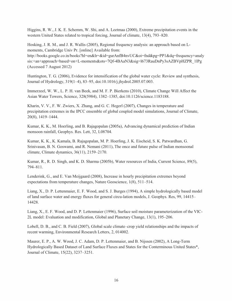
3.3 Hydrologic Modeling We will use the Variable Infiltration Capacity (VIC), SWAT, HEC-HMS, and HEC-RAS models to simulate hydrologic variables (soil moisture, runoff, evapotranspiration, subsurface flow, groundwater, and streamflow) and water quality parameters in the Sabarmati basin.
a. The Variable Infiltration Capacity Model: The VIC model (Liang et al. 1994, 1996) is a physically based hydrology model that solves a full energy and water balance for every grid cell (Fig. 6). The VIC model soil moisture estimates, in particular, have been widely evaluated (Maurer et al., 2002; Mishra et al., 2010). Moreover, the VIC model has been applied to reconstruct historical droughts in many previous studies (e.g., Mishra et al., 2010; and Mishra and Cherkauer, 2010; Sheffield et al. 2004).
The VIC model will be used to reconstruct historic time series for soil moisture, evapotranspiration, runoff, and groundwater levels in the Sabarmati River basin. We will also develop regional scale maps of meteorological, agricultural, and hydrological droughts for the retrospective and projected future climates. The retrospective droughts will be evaluated to understand drought frequency, severity, and areal extent in the Sabarmati River basin using similar analysis presented in Fig. 7. The recently added groundwater component (Rosenberg et al. 2012) in the VIC model will be used to derive groundwater level information in the Sabarmati basin. The VIC model will be applied to study the role of irrigation and reservoir operations under the historic and projected climate periods. The irrigation and reservoir schemes have been described in Haddeland et al., 2006a, 2006b and Haddeland et
Fig. 6 Schematic of the Variable Infiltration Capacity (VIC) model.

10
al., 2007. The baseline model parameters (soil and vegetation) and meteorological forcing (available at 0.5 degree) will be obtained from Sheffield et al. (2006). We will develop parameters and meteorological forcing to run the model at 1/16 degree (about 4 km) spatial resolution to provide high resolution climate projections. The future climate projections will be regridded at 1/16 degree resolution. The model runs will provide output for hydrologic variables (e.g. runoff, soil moisture, sub-surface flow, groundwater levels, streamflow, and evapotranspiration for retrospective and projected future climate change periods.
b. The Soil Water Assessment Tool (SWAT): The SWAT is a physically based watershed scale simulation model designed for use in gauged as well as ungauged basins to simulate long term effects of various watershed management decisions on hydrology and water quality response (Arnold et al., 1998). In the proposed work the SWAT model will be used to evaluate sensitivity of water quality/quantity parameters under the retrospective and projected future climates.
c. The HEC-RAS and HEC-HMS model: HEC-RAS/HMS is hydrologic modeling software developed by the US Army Corps of Engineers Hydrologic Engineering Centre (HEC). The HEC-RAS model will be used to simulate floodplain and flood elevation depth in the Sabarmati River basin. The HEC-RAS has been widely used for floodplain mapping and simulating flood elevations at multiple conditions (Drake et al., 2010; Cook and Merwade 2009; Sarhadi et al., 2012). We will use the VIC model simulated streamflow at various locations in the Sabarmati River basin as the input in the HEC-RAS model. The other geometric and hydraulic parameters will either be developed or will be collected from the available literature (see HEC-RAS user manual: http://www.hec.usace.army.mil/software/hec-ras/documents/HEC-RAS_4.1_Users_Manual.pdf). We will estimate flood elevations and the extent of flood plain for 50, 100, and 200 years flood magnitudes using the 1 and 5 day annual maximum streamflow for historic as well as projected climatic conditions at various locations in the Sabarmati River basin. The HEC-HMS is designed to be applicable in a wide range of geographic areas for solving the widest possible range of problems. This includes large river basin water supply and flood hydrology, and small urban or natural watershed runoff. The program is a generalized modeling system capable of representing many different watersheds. HEC-HMS uses separate sub-models to represent each component of the runoff process, including models that compute rainfall losses, runoff generation, base flow, and channel routing. Each model run combines the basin model, the precipitation model, and the control model. The basin model contains the basin and routing parameters of the model, as well as connectivity data for the basin. The precipitation model contains the rainfall data for the model. The control model contains all the timing information for the model. The user may specify different data sets for each model and then the hydrologic simulation is completed by using of data set for the basin model, the precipitation model, and the control model. The details of model structures and various processes involved are given in the
Fig. 7. Change in drought frequency during 1980-2008 with respect to 1950-1979 in India. Top, middle, and bottom panels show meteorological, hydrological, and agricultural droughts respectively (From Mishra et al

11
Technical Reference Manual (Feldman, 2000) and the User’s Manual (Scharffenberg and Fleming, 2010) of HEC-HMS. Hydrographs produced by the program are used directly or in conjunction with other software for studies of water availability, urban drainage, flow forecasting, future urbanization impact, reservoir spillway design, flood damage reduction, floodplain regulation, and systems operation. 3.4 Development of Meteorological Forcing for Hydrologic Modeling For both retrospective (1950 to present) and projected future climate (2010-2039; 2040-2069; 2070-2099), we will develop meterological forcing to run the VIC model. For retrospective climate, we will use station data and other gridded products for daily precipitation, maximum and minimum air temperature, and wind speed after appropriate gridding/interpolation at higher resolution (e.g. 1/16 degree). For projected future climate period, we will use downscaled and bias corrected forcings of daily precipitation, maximum and minimum air temperature, and wind speed. The period between 1961-1990 will be considered as the base line period to assess the projected future climate change impacts.
3.5 Climate and water resources indices to evaluate impacts of climate variability and climate
change
We will use Mann Kendall trend analysis (Mishra et al., 2010) to assess the changes in climate and hydrologic variables in the retrospective climate. The statistical significance tests will be performed to understand the spatial variability associated with the significant changes. For projected future climate, we will assess the significance of changes in mean and distribution using the Ranksum and Kolomogorov and Smirnov tests, respectively as described in Mishra and Lettenmaier (2011). We will identify the changes in different hydrologic variables (soil moisture, evapotranspiration, and surface and subsurface runoff) that may attribute to the changes in climate forcings (precipitation and temperature) using the methodology described in Thompson et al (2000). We will use following climate and hydrologic indices in our analysis: Time Period Index Short Term (1 day to 15 days) Heat waves, precipitation extremes, annual
maximum floods at various locations, low-flows, flood height, and flood plain extent
Seasonal (3 to 6 months) Precipitation, runoff, soil moisture, groundwater, evapotranspiration, droughts (hydrological, meteorological, and agricultural), and water quality parameters
Long Term (annual to decadal scales) Monsoon season precipitation, air temperature during crop growing season, streamflow, and groundwater levels
3.6 Uncertainty Analysis Since we will use meteorological forcings from the multiple GCMs, it is likely that climate forcings as well as hydrologic outputs will show inter-model differences. Therefore, we will conduct analysis on uncertainty associated with climate forcings as well as hydrologic and water resources scenarios in different projected future climate periods. Apart from the inter-model differences, hydrologic scenarios will differ from each other based on different Representative Concentration Pathways (RCPs: 2.6, 4.5,

12
6.0, and 8.5) used in the CMIP 5 projections, we will therefore consider variations in mean and distribution in hydrologic scenarios under these RCPs. Our project will provide uncertainty assessment on following aspects:
i) Uncertainty from multiple GCMs
ii) Uncertainty from multiple RCPs of single GCM
iii) Uncertainty from hydrologic scenarios
iv) Uncertainty from parameterization of hydrologic models
v) Uncertainty from downscaling (dynamical and statistical) approaches.
4. Work Plan: The proposed work will consists of the following major tasks. Task 1. Data Collection (IIT GN, SVNIT) We will make efforts to collect and analyze data from various sources for soil, land use and land cover, streamflow, meteorological inputs (precipitation, maximum and minimum temperature, wind, solar radiation), and groundwater levels. These datasets will be manipulated and analyzed using various techniques to make them appropriate for inputs in hydrologic models. Task 2. Processing future climate projections (IITGN) The projected future climate data will be obtained from IITB, IITD, and IITM for various RCPs (2.6, 4.5, 6.0, and 8.5) and a vast library of downscaled data will be developed for climate change scenarios at regional scales. The data will be then regridded at 1/16 degree spatial resolution.
Task 3. Development of the hydrologic modeling framework (IITGN)
We will use the Variable Infiltration Capacity (VIC) and SWAT models in our hydrologic modeling framework. The VIC model has been applied in both large as well as medium size river basins (Maurer et al., 2002; Mishra et al., 2010). The model needs daily meteorological forcing (precipitation, minimum and maximum air temperature, and wind speed) as well as soil and vegetation parameters at each grid cell. We intend to use the model at 1/16 degree spatial resolution and daily time step. The same meteorological forcing data will be used to derive the SWAT model. Observed streamflow at multiple gage stations will be required for the calibration and evaluation of the VIC and SWAT models at daily and monthly time-steps which will be obtained from the MoWR. The models will be calibrated and evaluated at upstream and downstream of the Dharoi dam. For the downstream of the Dharoi reservoir, naturalized streamflow (that incorporate reservoir operation scheme) will be used for the calibration and evaluation of the models. The models will be calibrated and evaluated at various locations based on the availability of the observed streamflow. This hydrologic modeling framework will be used for retrospective analysis and developing hydrologic scenarios under the projected future climate.
Task 4. Optimization of reservoir operation and irrigation planning (SVNIT)
We will use multiobjective optimization to evaluate reservoir operation and planning in the historic and projected climate conditions. This will include both planning for drinking water as well as for irrigation. The reservoir inflow will be estimated using the VIC and SWAT models. Inflow and reservoir capacity data along with the water demands scenarios will be used to develop optimization scenarios. The

13
optimized flow downstream of the reservoir will be used to evaluate water supply and demands in the downstream regions.
Task 5. Understanding retrospective hydroclimatological changes (IITGN, SVNIT)
We will diagnose retrospective (1950-present) hydrologic (mean and extremes) changes and variability in the Sabarmati River basin. Trends/changes in seasonal means of precipitation, air temperature, soil moisture, evapotranspiration, groundwater levels, water quality, and runoff will be estimated using the non-parametric Mann-Kendall trend method (Mishra et al., 2010). The spatial and temporal variability associated with the changes in hydrologic variables will be studied. The changes in hydrologic extremes (droughts and floods) will also be estimated for the same (1950-2008) period. For the drought analysis, we will consider meteorological, hydrological, and agricultural droughts using the standardized precipitation index (SPI), standardized runoff index (SRI), and soil moisture percentiles (SMP) as described in Mishra et al.(2010b),Mishra and Cherkauer (2010). We will use precipitation data to estimate SPI, while model simulated runoff and soil moisture data will be used to estimate SRI and SMP. We will especially focus on the droughts during the monsoon season (JJAS) as the basin receives more than 70 % of precipitation during this season.
For the flood analysis, we will diagnose changes in observed as well as reconstructed (using the VIC model) streamflow at gage stations. We will use model simulated runoff to understand the spatial nature of flood events and associated contributing regions within the basin. The simulated streamflow will be assessed at the upstream of the reservoir that are key to water storage and hydropower production. We will estimate 50, 100, 200 years flood at various durations under retrospective climate and associated flood elevations and floodplain extent using the HEC-RAS model. We will study the key urban flooding events under the retrospective climate using the HEC-HMS model. Changes in frequency and intensity of precipitation extremes will be studied using the gridded rainfall datasets in the neighborhood of urban areas using the approach described in Mishra and Lettenmaier (2011). The regional frequency analysis will be conducted for both floods and droughts after selecting appropriate probability distribution functions as described in Hosking and Wallis (1997). The analysis of water quality parameters will be carried out using the SWAT model.
Task6. Role of initial hydrologic conditions and atmospheric forcings in flood generation process (IITGN)
Extreme rainfall events may lead to flooding in the basin; however, hydrologic initial conditions also play a vital role in defining how the basin will respond to a particular extreme precipitation event. The contributing source areas within the basin may also vary in different extreme precipitation events. In the proposed work, we intend to setup hydrologic modeling experiments that will help us to identify the role(s) of initial conditions and atmospheric forcings in the flood generation process. We will classify precipitation extremes (> 95th percentile of long-term daily precipitation) based on initial hydrologic conditions (dry and wet) prior to precipitation events. We will then run the VIC and SWAT models using combinations of initial hydrologic conditions and magnitude of precipitation extremes. We will repeat the similar modeling experiments to understand role of hydrologic conditions in various parts of the basin to identify the most sensitive region to flood generation process. These hydrologic sensitivity experiments based on the retrospective climate will enable us to diagnose separate roles of initial hydrologic
14
conditions, atmospheric forcings, and source areas within the Sabarmati River basin in flood generation process.
Task 7. Development of hydrologic scenarios for the projected future climate (IITGN)
We will develop hydrologic scenarios for the projected future climate for the Sabarmati River basin. The hydrologic scenarios will be developed for the three periods: near term (2010-2039); mid-term (2040-2069), long term (2070-2099). Changes in soil moisture, surface and sub-surface runoff, evapotranspiration, groundwater levels, water quality, and streamflow will be assessed under the projected climate using the VIC and SWAT models. We will also develop scenarios for the frequency and severity of hydrologic extremes (drought and floods) ,flood elevations and flood plain maps using the HEC-RAS/HMS models. Urban flooding scenarios under the future climate will be developed for key urban areas located within the Sabarmati River basin. For drought analysis, we will focus on meteorological, hydrological, and agricultural droughts using the severity-area-duration analysis. For flood analysis at various gauge stations within the Sabarmati River basin, we will use regional flood frequency analysis using the methodology described in the Hoskings and Wallis (1997). Apart from hydrologic variables, we will also develop scenarios for extreme precipitation events as well as heat waves in the Sabarmati River basin. Long-term changes in monsoon season climate will be assessed using the downscaled projected climate change scenarios. Changes and variability in air temperature during the key crop growing seasons are vital for agricultural production (Lobell and Field, 2007), therefore, our projected climate and hydrologic scenarios will be used to assess plausible changes in agricultural production.
Task 8. Implications of projected hydrologic and climate changes (IITGN,SVNIT)
Hydrologic projections developed in the Task 7 will be evaluated in the context of retrospective climate. We will do rigorous analysis focusing on implications of hydrologic changes at various spatial ( sub-watershed to watershed) and temporal (daily to annual) scales. The implications of projected hydrologic/climate changes would be assessed for agriculture, water storage in reservoirs, irrigation demands, water quality, and water availability during the various seasons. Implications of the projected changes in frequency and magnitude of hydrologic extremes will be evaluated in the context of hydrologic design for flood protection and management of long –lasting, wide-spread droughts.
5. Expected Outcomes and Project Deliverables: The expected outputs from the project are listed below:
1. Collection of long-term datasets 2. Development of calibrated and evaluated hydrologic modelling framework 3. Development of high resolution downscaled and bias corrected climate and hydrologic scenarios 4. Detailed assessment of retrospective change and changes that are likely to occur under the
projected future climate 5. Reservoir and irrigation optimization 6. Training of graduate and post graduate students
References:

15
Allen, M. R., W. J. Ingram, and others (2002), Constraints on future changes in climate and the hydrologic cycle, Nature, 419(6903), 224–232.
Arnold, J. G., Srinivasan, R., Muttiah, R. S., and Allen, P. M.: Continental scale simulation of the hydrologic balance, J. Am.Water Resour. As., 35(5), 1037–1051, 1999.
Arora, V. K., and G. J. Boer (2001), Effects of simulated climate change on the hydrology of major river basins, J. Geophys. Res., 106(D4), 3335–3348, doi:10.1029/2000JD900620.
Barnett, T. P., J. C. Adam, and D. P. Lettenmaier (2005), Potential impacts of a warming climate on water availability in snow-dominated regions, Nature, 438(7066), 303–309.
Cook, A., and V. Merwade (2009), Effect of topographic data, geometric configuration and modeling approach on flood inundation mapping, Journal of Hydrology, 377(1), 131–142.
Dai, A., K. E. Trenberth, T. R. Karl, and others (1998), Global variations in droughts and wet spells: 1900-1995, Geophysical Research Letters, 25(17), 3367–3370.
Dai, A., T. Qian, K. E. Trenberth, and J. D. Milliman (2009), Changes in Continental Freshwater Discharge from 1948 to 2004, Journal of Climate, 22(10), 2773–2792, doi:10.1175/2008JCLI2592.1.
Drake, J., A. Bradford, and D. Joy (2010), Application of HEC-RAS 4.0 temperature model to estimate groundwater contributions to Swan Creek, Ontario, Canada, Journal of Hydrology, 389(3), 390–398.
Easterling, D. R., G. A. Meehl, C. Parmesan, S. A. Changnon, T. R. Karl, and L. O. Mearns (2000), Climate Extremes: Observations, Modeling, and Impacts, Science, 289(5487), 2068–2074, doi:10.1126/science.289.5487.2068.
Feldman, A. D. (2000), Hydrologic Modeling System HEC-HMS: Technical Reference Manual, US Army Corps of Engineers, Hydrologic Engineering Center.
Gosain, A. K., S. Rao, and D. Basuray (2006), Climate change impact assessment on hydrology of Indian river basins, Current Science, 90(3), 346–353.
Gutowski Jr, W. J., E. S. Takle, K. A. Kozak, J. C. Patton, R. W. Arritt, and J. H. Christensen (2007), A possible constraint on regional precipitation intensity changes under global warming, Journal of Hydrometeorology, 8(6), 1382–1396.
Haddeland, I., D. P. Lettenmaier, and T. Skaugen (2006a), Effects of irrigation on the water and energy balances of the Colorado and Mekong river basins, Journal of Hydrology, 324(1), 210–223.
Haddeland, I., T. Skaugen, and D. P. Lettenmaier (2006b), Anthropogenic impacts on continental surface water fluxes, Geophysical research letters, 33(8), L08406.
Haddeland, I., T. Skaugen, and D. P. Lettenmaier (2007), Hydrologic effects of land and water management in North America and Asia: 1700-1992, Hydrology and Earth System Sciences Discussions, 11(2), 1035–1045.
16
Higgins, R. W., J. K. E. Schemm, W. Shi, and A. Leetmaa (2000), Extreme precipitation events in the western United States related to tropical forcing, Journal of climate, 13(4), 793–820.
Hosking, J. R. M., and J. R. Wallis (2005), Regional frequency analysis: an approach based on L-moments, Cambridge Univ Pr. [online] Available from: http://books.google.co.in/books?hl=en&lr=&id=gurAnfB4nvUC&oi=fnd&pg=PP1&dq=frequency+analysis:+an+approach+based+on+L-moments&ots=7Qf-4BAaN3&sig=l673RauDnPy3sAZBVpHZPR_1lPg (Accessed 7 August 2012)
Huntington, T. G. (2006), Evidence for intensification of the global water cycle: Review and synthesis, Journal of Hydrology, 319(1–4), 83–95, doi:10.1016/j.jhydrol.2005.07.003.
Immerzeel, W. W., L. P. H. van Beek, and M. F. P. Bierkens (2010), Climate Change Will Affect the Asian Water Towers, Science, 328(5984), 1382–1385, doi:10.1126/science.1183188.
Kharin, V. V., F. W. Zwiers, X. Zhang, and G. C. Hegerl (2007), Changes in temperature and precipitation extremes in the IPCC ensemble of global coupled model simulations, Journal of Climate, 20(8), 1419–1444.
Kumar, K. K., M. Hoerling, and B. Rajagopalan (2005a), Advancing dynamical prediction of Indian monsoon rainfall, Geophys. Res. Lett, 32, L08704.
Kumar, K. K., K. Kamala, B. Rajagopalan, M. P. Hoerling, J. K. Eischeid, S. K. Patwardhan, G. Srinivasan, B. N. Goswami, and R. Nemani (2011), The once and future pulse of Indian monsoonal climate, Climate dynamics, 36(11), 2159–2170.
Kumar, R., R. D. Singh, and K. D. Sharma (2005b), Water resources of India, Current Science, 89(5), 794–811.
Lenderink, G., and E. Van Meijgaard (2008), Increase in hourly precipitation extremes beyond expectations from temperature changes, Nature Geoscience, 1(8), 511–514.
Liang, X., D. P. Lettenmaier, E. F. Wood, and S. J. Burges (1994), A simple hydrologically based model of land surface water and energy fluxes for general circu-lation models, J. Geophys. Res, 99, 14415–14428.
Liang, X., E. F. Wood, and D. P. Lettenmaier (1996), Surface soil moisture parameterization of the VIC-2L model: Evaluation and modification, Global and Planetary Change, 13(1), 195–206.
Lobell, D. B., and C. B. Field (2007), Global scale climate–crop yield relationships and the impacts of recent warming, Environmental Research Letters, 2, 014002.
Maurer, E. P., A. W. Wood, J. C. Adam, D. P. Lettenmaier, and B. Nijssen (2002), A Long-Term Hydrologically Based Dataset of Land Surface Fluxes and States for the Conterminous United States*, Journal of Climate, 15(22), 3237–3251.
17
Meehl, G. A., W. D. Collins, B. A. Boville, J. T. Kiehl, T. M. L. Wigley, and J. M. Arblaster (2000), Response of the NCAR Climate System Model to increased CO2 and the role of physical processes, Journal of Climate, 13(11), 1879–1898.
Milesi, C., A. Samanta, H. Hashimoto, K. K. Kumar, S. Ganguly, P. S. Thenkabail, A. N. Srivastava, R. R. Nemani, and R. B. Myneni (2010), Decadal variations in NDVI and food production in India, Remote Sensing, 2(3), 758–776.
Milly, P. C. D., R. T. Wetherald, K. A. Dunne, and T. L. Delworth (2002), Increasing risk of great floods in a changing climate, Nature, 415(6871), 514–517, doi:10.1038/415514a.
Min, S. K., X. Zhang, F. W. Zwiers, and G. C. Hegerl (2011), Human contribution to more-intense precipitation extremes, Nature, 470(7334), 378–381.
Mishra, V., and K. A. Cherkauer (2010), Retrospective droughts in the crop growing season: Implications to corn and soybean yield in the Midwestern United States, Agricultural and Forest Meteorology, 150(7), 1030–1045.
Mishra, V., and D. P. Lettenmaier (2011), Climatic trends in major US urban areas, 1950–2009, Geophysical Research Letters, 38(16), L16401.
Mishra, V., K. A. Cherkauer, and S. Shukla (2010), Assessment of drought due to historic climate variability and projected future climate change in the Midwestern United States, Journal of Hydrometeorology, 11(1), 46–68.
Mishra, V., B. V. Smoliak, D. P. Lettenmaier, and J. M. Wallace (2012a), A prominent pattern of year-to-year variability in Indian Summer Monsoon Rainfall, PNAS, 109(19), 7213–7217, doi:10.1073/pnas.1119150109.
Mishra, V. R. Krishanan, and J. M. Wallace (2012b), Trends in monsoon climate in India (to be submitted in Geophysical Research Letters)
Mishra, V., C. Funk, D. Niyogi, D. P. Lettenmaier (2012b), Evaluation of food and water security risks under climate change in India ( to be submitted in Environmental Research Letters) Ramanathan, V., C. Chung, D. Kim, T. Bettge, L. Buja, J. T. Kiehl, W. M. Washington, Q. Fu, D. R. Sikka, and M. Wild (2005), Atmospheric brown clouds: Impacts on South Asian climate and hydrological cycle, Proceedings of the National Academy of Sciences of the United States of America, 102(15), 5326.
Rodell, M., I. Velicogna, and J. S. Famiglietti (2009), Satellite-based estimates of groundwater depletion in India, Nature, 460(7258), 999–1002.
Sarhadi, A., S. Soltani, and R. Modarres (2012), Probabilistic flood inundation mapping of ungauged rivers: Linking GIS techniques and frequency analysis, Journal of Hydrology, 458–459(0), 68–86, doi:10.1016/j.jhydrol.2012.06.039.
Scharffenberg, W., and M. Fleming (2010), Hydrologic modeling system HEC-HMS v3. 2 user’s manual, Davis, USA, USACE-HEC.
18
Schlenker, W., W. M. Hanemann, and A. C. Fisher (2007), Water availability, degree days, and the potential impact of climate change on irrigated agriculture in California, Climatic Change, 81(1), 19–38.
Sheffield, J., and E. Wood (2008), Projected changes in drought occurrence under future global warming from multi-model, multi-scenario, IPCC AR4 simulations, Climate Dynamics, 31(1), 79–105, doi:10.1007/s00382-007-0340-z.
Sheffield, J., G. Goteti, F. Wen, and E. F. Wood (2004), A simulated soil moisture based drought analysis for the United States, J. Geophys. Res, 109, D24108.
Sheffield, J., G. Goteti, and E. F. Wood (2006), Development of a 50-year high-resolution global dataset of meteorological forcings for land surface modeling, Journal of Climate, 19(13), 3088–3111.
Siebert, S., J. Burke, J. M. Faures, K. Frenken, J. Hoogeveen, P. Döll, and F. T. Portmann (2010), Groundwater use for irrigation – a global inventory, Hydrology and Earth System Sciences Discussions, 7(3), 3977–4021, doi:10.5194/hessd-7-3977-2010.
Tanaka, S. K., T. Zhu, J. R. Lund, R. E. Howitt, M. W. Jenkins, M. A. Pulido, M. Tauber, R. S. Ritzema, and I. C. Ferreira (2006), Climate warming and water management adaptation for California, Climatic Change, 76(3), 361–387.
Thompson, D. W. J., J. M. Wallace, and G. C. Hegerl (2000), Annular modes in the extratropical circulation. Part II: Trends, Journal of Climate, 13(5), 1018–1036.
Trenberth, K. E., A. Dai, R. M. Rasmussen, and D. B. Parsons (2003), The changing character of precipitation, Bulletin of the American Meteorological Society, 84(9), 1205–1218.
Vörösmarty, C. J., P. Green, J. Salisbury, and R. B. Lammers (2000), Global Water Resources: Vulnerability from Climate Change and Population Growth, Science, 289(5477), 284–288, doi:10.1126/science.289.5477.284.
Vörösmarty, C. J. et al. (2010), Global threats to human water security and river biodiversity, Nature, 467(7315), 555–561, doi:10.1038/nature09440.
Wilhite, D. A., M. V. K. Sivakumar, and D. A. Wood (2000), Early warning systems for drought preparedness and drought management, World Meteorological Organization. [online] Available from: http://www.wamis.org/agm/pubs/agm2/agm02.pdf (Accessed 6 August 2012)
Wisser, D., S. Frolking, E. M. Douglas, B. M. Fekete, C. J. Vörösmarty, and A. H. Schumann (2008), Global irrigation water demand: Variability and uncertainties arising from agricultural and climate data sets, Geophys. Res. Lett., 35(24), L24408, doi:10.1029/2008GL035296.
Wood, A. W., L. R. Leung, V. Sridhar, and D. P. Lettenmaier (2004), Hydrologic implications of dynamical and statistical approaches to downscaling climate model outputs, Climatic Change, 62(1), 189–216.

19
Tasks and time frame
Tasks
Year 1
Year 2
Year 3
Q1 Q2 Q3 Q4 Q1 Q2 Q3 Q4 Q1 Q2 Q3 Q4 Task 1 Task 2 Task 3 Task 4 Task 5 Task 6 Task 7 Task 8 Writing (Journal/conference articles) Writing (reports)
(Q: quarter)
Release of Budget (year wise)
1. Year 1. At the start of the project 2. Year 2. On the completion of the Task 1 and Task 2 3. Year 3. On the completion of the Tasks 3, 4, 5, and 6