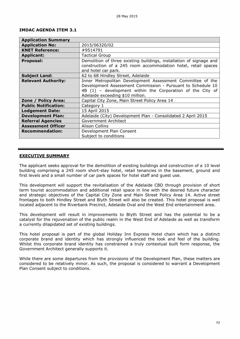
imdac agenda item application summary application no€¦ · application summary application no:...
TRANSCRIPT
28 May 2015
P2
IMDAC AGENDA ITEM 3.1
Application Summary
Application No: 2015/06320/02 KNET Reference: #9514791 Applicant: Tactical Group Proposal: Demolition of three existing buildings, installation of signage and
construction of a 245 room accommodation hotel, retail spaces and hotel car park.
Subject Land: 62 to 68 Hindley Street, Adelaide Relevant Authority: Inner Metropolitan Development Assessment Committee of the
Development Assessment Commission - Pursuant to Schedule 10 4B (1) – development within the Corporation of the City of Adelaide exceeding $10 million.
Zone / Policy Area: Capital City Zone, Main Street Policy Area 14 Public Notification: Category 1 Lodgement Date: 15 April 2015 Development Plan: Adelaide (City) Development Plan - Consolidated 2 April 2015 Referral Agencies Government Architect Assessment Officer Alison Collins Recommendation: Development Plan Consent
Subject to conditions
EXECUTIVE SUMMARY
The applicant seeks approval for the demolition of existing buildings and construction of a 10 level building comprising a 245 room short-stay hotel, retail tenancies in the basement, ground and first levels and a small number of car park spaces for hotel staff and guest use. This development will support the revitalisation of the Adelaide CBD through provision of short term tourist accommodation and additional retail space in line with the desired future character and strategic objectives of the Capital City Zone and Main Street Policy Area 14. Active street frontages to both Hindley Street and Blyth Street will also be created. This hotel proposal is well located adjacent to the Riverbank Precinct, Adelaide Oval and the West End entertainment area. This development will result in improvements to Blyth Street and has the potential to be a catalyst for the rejuvenation of the public realm in the West End of Adelaide as well as transform a currently dilapidated set of existing buildings. This hotel proposal is part of the global Holiday Inn Express Hotel chain which has a distinct corporate brand and identity which has strongly influenced the look and feel of the building. Whilst this corporate brand identity has constrained a truly contextual built form response, the Government Architect generally supports it. While there are some departures from the provisions of the Development Plan, these matters are considered to be relatively minor. As such, the proposal is considered to warrant a Development Plan Consent subject to conditions.
28 May 2015
P3
ASSESSMENT REPORT
1. BACKGROUND
1.1 Strategic context
In March 2012, there was a significant review of the City’s planning policies. The new policy
framework moved towards a city form that aligned with the directions of the 30-Year Plan for
Greater Adelaide and sought to create a more active and vibrant city.
1.2 Pre-lodgement Process
The proposal was presented to the pre-lodgement panel and the Design Review Panel on two occasions. The pre-lodgement panel included representatives from Adelaide City Council’s
Administration and the Office of Design and Architecture SA. Key changes to the project arising from the pre-lodgement process include:
Inclusion of a retail space fronting the loading zone and Blyth Street to activate this frontage.
Continuous footpath treatment along Blyth Street to prioritise pedestrian movements and amenity.
Increased articulation and shading on the western façade. Articulation of the individual ground floor retail spaces fronting Hindley Street to better
connect to the local context.
Discussions about the proposed Blyth Street public realm treatments are continuing with Adelaide City Council and are proposed to be subject of a condition. 2. DESCRIPTION OF PROPOSAL
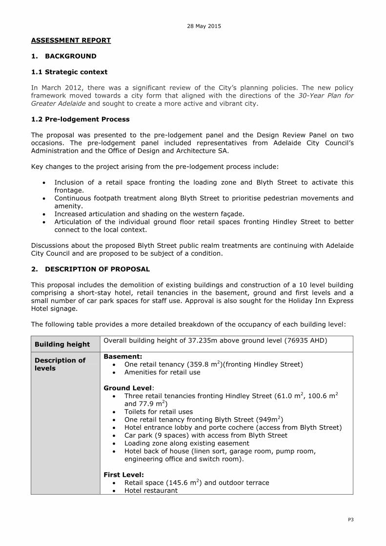
This proposal includes the demolition of existing buildings and construction of a 10 level building comprising a short-stay hotel, retail tenancies in the basement, ground and first levels and a small number of car park spaces for staff use. Approval is also sought for the Holiday Inn Express Hotel signage. The following table provides a more detailed breakdown of the occupancy of each building level:
Building height Overall building height of 37.235m above ground level (76935 AHD)
Description of
levels
Basement:
One retail tenancy (359.8 m2)(fronting Hindley Street) Amenities for retail use
Ground Level: Three retail tenancies fronting Hindley Street (61.0 m2, 100.6 m2
and 77.9 m2) Toilets for retail uses One retail tenancy fronting Blyth Street (949m2) Hotel entrance lobby and porte cochere (access from Blyth Street) Car park (9 spaces) with access from Blyth Street Loading zone along existing easement Hotel back of house (linen sort, garage room, pump room,
engineering office and switch room). First Level:
Retail space (145.6 m2) and outdoor terrace Hotel restaurant

28 May 2015
P4
Three meeting rooms Luggage, administration, gym and guest toilets Hotel back of house (Linen store, kitchen, amenity store, staff
lockers, staff dining room, laundry, staff toilets and server)
Second to Fourth Level: 30 hotel rooms (including two disability compliant rooms) each level Maids and mechanics room
Fifth to Ninth Level:
31 hotel rooms (including one disability compliant room) each level Summary:
Hotel: 7810.6 m2 245 room hotel Retail: 923.5 m2 Car parking spaces: 9 (including one disabled) 11 bicycle parking racks
Other features of the development:
Holiday Inn Express Hotel signage Footpath (with the subject site) with trees in planter boxes
Site Access Two double crossovers proposed at Blyth Street to access hotel car park and porte cochere. Waste vehicles and delivery vehicles will use the loading area located on the existing easement (accessed off Blyth Street). All access to the hotel with be from Blyth Street (including car park, porte cochere and hotel lobby). Waste collection and delivers for both the retail and hotel functions will be from Blyth Street. Pedestrian access to one of the ground floor retail tenancies will also be from Blyth Street. The other three ground floor and basement tenancies will be accessed directly from Hindley Street.
Encroachments There is a canopy on the Hindley Street facade which encroaches 2.8m metres over the footpath at a height of 4 metres.
3. SITE AND LOCALITY
3.1 Site and Locality Description
The subject site is located at 62 to 68 Hindley Street (on the eastern corner of Hindley Street and Blyth Street) and is described as follows:
Lot No Plan Street Suburb Hundred CT Reference
645 181487 Hindley Street Adelaide Adelaide 4254/967
The subject land has a total site area of 1,785 m2 with frontages of 25 metres to Hindley Street and 65 metres to Blyth Street. The development site currently accommodates three existing attached buildings, namely ‘L.C. House’ (comprising three stories with basement), ‘Building 2’ (two stories with basement) and a single storey undercover car park. The majority of the existing buildings are currently vacant, apart from the ground floor of L.C. House which has a restaurant, bookshop and a retail tenancy fronting Hindley Street.
28 May 2015
P5
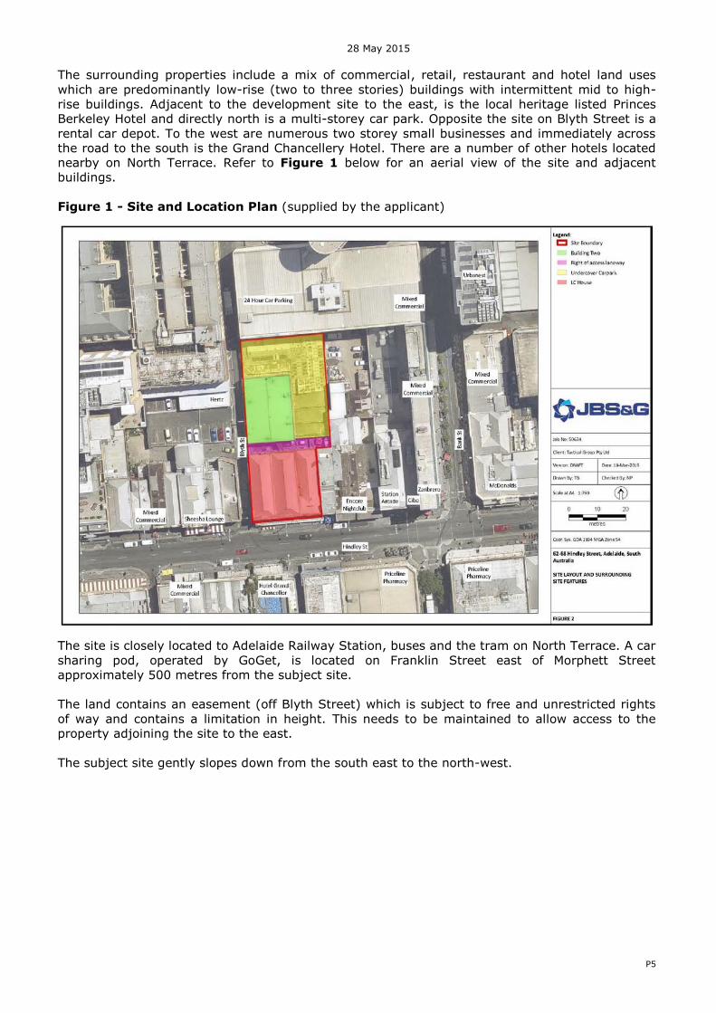
The surrounding properties include a mix of commercial, retail, restaurant and hotel land uses which are predominantly low-rise (two to three stories) buildings with intermittent mid to high-rise buildings. Adjacent to the development site to the east, is the local heritage listed Princes Berkeley Hotel and directly north is a multi-storey car park. Opposite the site on Blyth Street is a rental car depot. To the west are numerous two storey small businesses and immediately across the road to the south is the Grand Chancellery Hotel. There are a number of other hotels located nearby on North Terrace. Refer to Figure 1 below for an aerial view of the site and adjacent buildings. Figure 1 - Site and Location Plan (supplied by the applicant)
The site is closely located to Adelaide Railway Station, buses and the tram on North Terrace. A car sharing pod, operated by GoGet, is located on Franklin Street east of Morphett Street approximately 500 metres from the subject site. The land contains an easement (off Blyth Street) which is subject to free and unrestricted rights of way and contains a limitation in height. This needs to be maintained to allow access to the property adjoining the site to the east.
The subject site gently slopes down from the south east to the north-west.
28 May 2015
P6
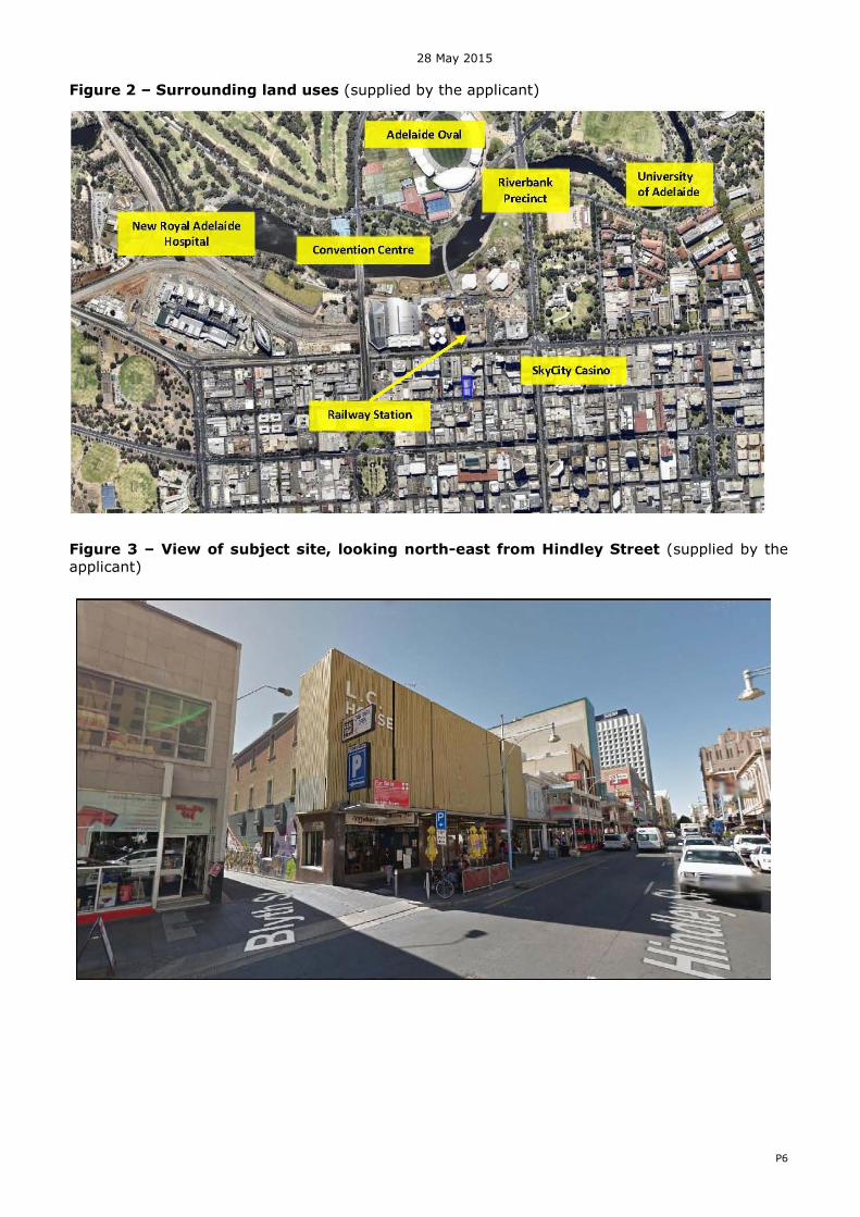
Figure 2 – Surrounding land uses (supplied by the applicant)
Figure 3 – View of subject site, looking north-east from Hindley Street (supplied by the applicant)

28 May 2015
P7
Figure 4 –View of subject site, looking westwards (supplied by the applicant)
Figure 5 - View of subject site looking north down Blyth Street

28 May 2015
P8
4. REFERRAL BODY / COUNCIL FEEDBACK
4.1 Government Architect (Statutory – Advisory) The proposal was considered by the Design Review Panel on two occasions, over which period the design response progressed significantly. The Government Architect’s advice is discussed in detail in the body of the report. Refer to the Attachments for a copy of the full referral letter.
4.2 Adelaide City Council (Non-Statutory)
Although there is no formal statutory referral to Adelaide City Council, Council’s administration was consulted through the pre-lodgement and assessment process. Council’s administration is investigating opportunities to upgrade Blyth Street to improve pedestrian connectively between Hindley Street, North Terrace and ultimately the Riverbank. This application includes a pedestrian space around the building which has a number of activation benefits. The applicant has agreed to continue discussions about how the footpath treatment could best integrate with any future upgrade to Blyth Street. There is a condition of approval recommended to allow on-going discussions with Council to resolve a final footpath design as Council’s plans for the street evolve. At the completion of the pre-lodgement process, Adelaide City Council’s waste officer provided final feedback on the proposal indicating that waste management had been appropriately addressed. A canopy encroachment onto Hindley Street is proposed which has received in-principle support from Council’s administration and will be approved as a variation under their Encroachment Policy. Public artwork currently attached to the walls of one of existing buildings will be returned to council and has therefore been included as a condition.
5. PUBLIC NOTIFICATION
The application is a Category 1 development and as such public notification is not required. 6. POLICY OVERVIEW
The site is located within the Capital City Zone and Main Street Policy Area 14 as prescribed by the Adelaide (City) Development Plan (Consolidated 2 April, 2015). Refer to Figure 6 below. The proposal is neither complying nor non-complying within the zone and will be assessed on its merits against all relevant provisions of the Development Plan.

28 May 2015
P9
Figure 6: Zoning Map
Capital City Zone / Main Street Policy Area 14
The Capital City Zone is the economic and cultural focus of the State and includes a range of employment, community, educational, tourism and entertainment facilities. The zone encourages a diverse range of land uses with non-residential uses at the ground floor which encourage a high level of pedestrian activity at the street level, together with a variety of medium to high scale residential development above. The Main Street Policy Area 14 extends along the length of Hindley Street, Rundle Mall and Rundle Street. Hindley Street (east of Morphett Street) is the City’s focus for late night
entertainment and will be carefully designed and managed to integrate effectively with day time and evening land use activities. The Main Street policy area calls for a vibrant mixture of land uses that support a strong retail base and a continuing program of on-street arts and activities. Land uses will contribute to the day and evening economies and be managed to ensure a positive contribution to the character of the precinct. In summary the desired character and policies for the Capital City Zone and the Main Street Policy Area 14 seek the following key outcomes:
High scale development with high street walls that frame the streets; There is no prescribed height limit (but for airports height limit) upon the subject land; An increase in residential density, ground level activity, employment opportunities and
enhanced pedestrian movement is sought; Active non-residential land uses at ground floor and medium to high density residential
development at the upper levels; A high level of pedestrian amenity and interest, together with activation and passive
surveillance of the public realm; A high standard of architectural design and detailing with quality materials and finishes to
reflect the importance of the zone; Within the Main Street Policy Area activities including retail, restaurants, cafés and licensed
premises will contribute to the day and evening economies; Upper levels of buildings are to be recessed behind a moderately scaled building street wall
to maintain a sense of spaciousness and openness to the sky; and
SUBJECT LAND

28 May 2015
P10
Continuity of verandahs, canopies or pedestrian shelters, and ceiling heights is desired to maintain a sheltered, high amenity pedestrian environment at a human scale.
Council Wide
The Council Wide provisions provide direction on the desire for increased levels of activity and interest at ground level; the safe and convenient servicing of sites; a high standard of design and appropriate bulk and scale of buildings and contribution to streetscape. Relevant planning policies are contained in the concluding appendices and relevant zoning maps are in the attachments. 7. PLANNING ASSESSMENT
The following elements are considered to be of the most relevance to the assessment of the proposal against the Development Plan. The primary areas of discussion include:
Land use Building height Built form and relationship to local context Design and appearance Street activation Interface impacts Sense of arrival Pedestrian movement and amenity Traffic management, access and parking Waste Management Acoustics Crime Prevention Sustainability and stormwater management Site contamination Signage
7.1 Land use
The proposed 10 level hotel and ground and first floor retail tenancies are envisioned within the Capital City Zone and Main Street Policy Area 14:
O3 Hindley Street (east of Morphett Street) as the pre-eminent evening and late night
entertainment hub for metropolitan Adelaide, with complementary shopping, hospitality
and mixed business together with high density living.
The Government Architect, in her referral letter, also outlines her support for these land uses. A hotel use contributes to the day and night economy of the city and supports the uses of the zone. The hotel also does not provide a lunch or dinner food service, thus generating good demand for nearby local eateries and bars. 7.2 Building height
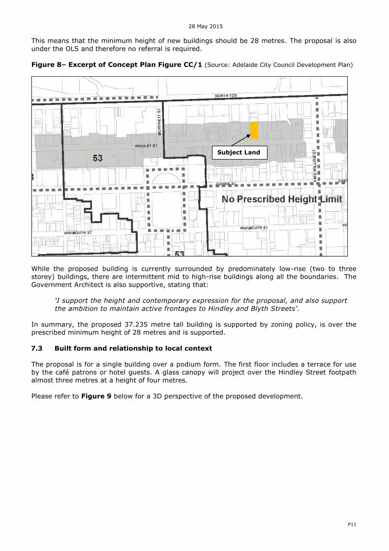
This development site is located within the ‘no prescribed height limit’ area of the Capital City Zone which envisages high scale development. Refer to Figure 8 below. PDC 20 also states that:
20 Development should have the optimal height and floor space yields that take advantage of the premium City location and should have a building height of no less than half the maximum shown on
the Concept Plan CC/1 and 2.
28 May 2015
P11
This means that the minimum height of new buildings should be 28 metres. The proposal is also under the OLS and therefore no referral is required.
Figure 8– Excerpt of Concept Plan Figure CC/1 (Source: Adelaide City Council Development Plan)
While the proposed building is currently surrounded by predominately low-rise (two to three storey) buildings, there are intermittent mid to high-rise buildings along all the boundaries. The Government Architect is also supportive, stating that:
‘I support the height and contemporary expression for the proposal, and also support
the ambition to maintain active frontages to Hindley and Blyth Streets’.
In summary, the proposed 37.235 metre tall building is supported by zoning policy, is over the prescribed minimum height of 28 metres and is supported.
7.3 Built form and relationship to local context
The proposal is for a single building over a podium form. The first floor includes a terrace for use by the café patrons or hotel guests. A glass canopy will project over the Hindley Street footpath almost three metres at a height of four metres.
Please refer to Figure 9 below for a 3D perspective of the proposed development.
Subject Land

28 May 2015
P12
Figure 9 – 3D Perspective of the proposed development (supplied by the applicant)
The Council Wide, Capital City and Main Street Policy Area 14 provisions all seek a high quality of design excellence and appropriate composition and proportion in a new building.
The proposed two level podium (set back some three metres) from Hindley Street is in line with PDC 11 for the zone and PDC 9 for the Main Street Policy Area 14 which outlines the desired podium street wall heights and setbacks for the upper levels of buildings with frontage to Hindley Street:
11 Other than in the Central Business Policy Area, buildings should be designed to include a podium/street wall height and upper level setback (in the order of 3-6 metres) that:
(a) relates to the width of the street and achieves a suitable level of enclosure to the public
realm; (b) provides a human scale at street level; (c) creates a well-defined and continuity of frontage;
(d) gives emphasis and definition to street corners to clearly define the street grid; (e) contributes to the interest, vitality and security of the pedestrian environment;
28 May 2015
P13
(f) maintains a sense of openness to the sky for pedestrians and brings daylight to the
street; and
(g) achieves pedestrian comfort by minimising micro climatic impacts (particularly wind tunnelling and downward drafts).
9 Buildings with a frontage to Gouger Street, Hindley Street or Rundle Street, west of Frome Street, should be designed to:
(a) Reinforce the prevailing datum heights and parapet levels of the street through design
elements that provide a clear distinction between levels above and below the prevailing datum line; and:
(b) Include a maximum podium/street wall height in the order of six storeys, with an upper level setback, measured from the street in the order of three metres.
The general massing and articulation of the podium is supported by the Government Architect. Whilst the parapet of the podium is higher than the adjacent Prince Berkeley Hotel, Hindley Street has a mix of podium heights and this departure is considered minor and will not detrimentally affect the overall streetscape. The desired character statement for the policy area provides the following guidance:
7 Development should include a variety of architectural expression and finishes compatible with the
many existing older buildings. Verandahs, balconies, awnings and parapets should be designed to
complement those existing.
8 Development should strengthen the established character of narrow building frontage widths, vertical massing and above street level, architectural detailing and ornamentation
The proposed contemporary building has attempted to respond to the local streetscape context by using columns to define the individual retail tenancies along its Hindley Street frontage and thus relate to adjacent narrow shop fronts. The first floor terrace, while not extending over the footpath like some of the other buildings on Hindley Street, still provides the benefits of an active frontage and passive surveillance. The Government Architect has expressed a view that the proposed glass awning is not as a convincing approach as an alternative option of having a balcony or colonnade extending over the footpath. While the proposed glass canopy is of a contemporary nature (in line with the overall proposal), it will be installed at the same height as the adjacent balcony of the local heritage listed Prince Berkeley Hotel. The canopy of the Hotel Grand Chancellor across the road is also the same height. Council’s administration has also confirmed support for this height and extent of footpath coverage to protect pedestrians from wind, rain and sun. It is also important to note that there are a wide range of canopies, verandahs and balconies used to protect pedestrian comfort and amenity along Hindley Street. The existing buildings on either side of the subject site also do not have a balcony or canopy at all. The contemporary nature and height of this canopy and its effectiveness in protecting pedestrian amenity and comfort is therefore considered acceptable in the local context.
7.4 Design and appearance
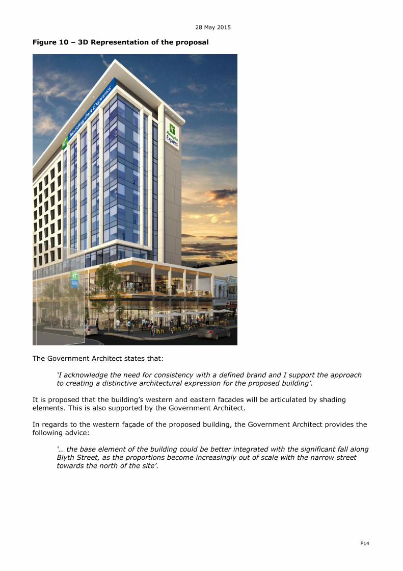
This hotel proposal is part of the international Holiday Inn Express Hotel chain which has a distinct corporate brand and identity which has strongly influenced the look and feel of the building. The applicant has prepared a schedule of materials and finishes, which has been submitted as part of the development application, and includes a combination of stone, glass, metal cladding and paint. Refer to the ATTACHMENTS. Refer to Figure 10 below for a 3D representation of the proposal, showing both the southern and western facades.
28 May 2015
P14
Figure 10 – 3D Representation of the proposal
The Government Architect states that:
‘I acknowledge the need for consistency with a defined brand and I support the approach
to creating a distinctive architectural expression for the proposed building’.
It is proposed that the building’s western and eastern facades will be articulated by shading
elements. This is also supported by the Government Architect. In regards to the western façade of the proposed building, the Government Architect provides the following advice:
‘… the base element of the building could be better integrated with the significant fall along
Blyth Street, as the proportions become increasingly out of scale with the narrow street
towards the north of the site’.
28 May 2015
P15
The Government Architect also provides the following advice in regards to the approach for the Blyth Street and Hindley Street corner where:
‘…the transition of the precast elements and curtain wall could be improved to provide a
stronger response to this prominent corner. To that end, a more unified approach to the
overall expression could achieve an integration of the contrasting materials proposed’.
This hotel proposal is part of the global Holiday Inn Express Hotel chain which has a distinct corporate brand and identity which has strongly influenced the look and feel of the building. This corporate brand identity has constrained a response to this advice from the Government Architect. However, while this design could be improved, it is still considered acceptable. This is because, this part of the building is articulated, the materials break up the massing and the ground level is activated with retail uses and street trees. The Development Plan also seeks that minor streets and laneways have a sense of enclosure and high street walls. It is also noted that the proposed services will be adequately screened or located away from public view.
7.5 Interface impacts
There are a range of provisions within the Development Plan aimed at ameliorating any unreasonable impacts of the development outside of the site, in particular, overshadowing and microclimatic impacts at street level.
7.5.1 Overshadowing
The Capital City Zone includes the following provision to ensure direct sunlight access to southern footpaths:
12 Buildings north of Rundle Mall, Rundle Street, Hindley Street and Gouger Street should have a built form that incorporates slender tower elements, spaces between buildings or other design techniques that enable sunlight access to the southern footpath.
While there will be additional shadowing, the shadow diagrams provided show that during the winter solstice on 21 June, the sections of Hindley Street to be shadowed by the proposal are already shadowed by other buildings. In addition, the proposal includes a slender tower which is set back some 5.3 metres from the eastern boundary and 3 metres from the southern boundary thus allowing sunlight to penetrate onto Hindley Street. The proposal also satisfies the provision of a podium which is sought by policy to ‘maintain a sense of openness to the sky for pedestrians and bring daylight to the
street’, (Capital City Zone, Principle of Development Control 11). 7.5.2 Micro Climate / Wind
The Development Plan anticipates that the microclimatic impacts of tall building should be ameliorated so as not to unreasonably impact pedestrian comfort at the street level:
125 Development that is over 21 metres in building height and is to be built at or on the street frontage should minimise wind tunnel effect.
A pedestrian wind environment statement (by Windtech) has been submitted as part of the application. The results of this assessment indicate that the Hindley Street and Blyth Street pedestrian footpaths will benefit from shielding from existing surrounding buildings, the proposed building and the canopy along the Hindley Street frontage. The inclusion of trees along the Blyth Street frontage is supported as a valuable wind mitigation tool.
28 May 2015
P16
7.6 Street activation
There is an emphasis both by the Capital City Zone and Main Street Policy Area that new development will enhance the public environment through the activation of city streets. In particular, the Development Plan seeks active and engaging uses at ground floor level to provide surveillance over the public realm and interest for pedestrians. Furthermore, the Mixed Use Policy Area14 seeks that:
5 The ground level street frontage of buildings should be designed as activated street frontages, provide pedestrian interest, and maximise passive surveillance by:
(a) providing at least 70 percent of the frontage as a non-residential use; and (b) 50 percent of the frontage as visually permeable, transparent or clear glazed and may include an entry/foyer or display window to a shop (including a café or restaurant).
In respect to the ground floor retail tenancies on the Hindley Street and Blyth Street frontages, clear and blue tinted glass will be used and therefore visually permeable. The ground floor frontage to Hindley Street is likely to encompass a cafe to provide a level of activity and pedestrian interest sought by the Zone and Policy Area. The inclusion of a retail space addressing both Blyth Street and internal easement creates further opportunities for laneway activation in line with the State Government’s and Adelaide City Council’s Vibrant City agenda. The Government Architect also supports this.
7.7 Sense of arrival
The hotel entrance is located off Blyth Street, at the rear of the porte cochere.
The Government Architect provides the following advice regarding the proposed building:
‘…. being of significant size and on a prominent site in this part of the city, my support
for the scheme is contingent on achieving good design outcomes. To that end, in my
view further refinement of the ground floor configuration is required in order to achieve
a clear sense of address and better integration with Blyth Street’.
The location of the hotel entrance off Blyth Street, allows the Hindley Street ground floor frontage to be dedicated to retail uses, thus supporting the desired character of this zone and policy area. The Government Architect supports this approach. Setting back the hotel entrance is required to allow for the porte cochere and maintaining appropriate traffic flow on Blyth Street. The proposed signage is considered to provide the necessary direction, which is included in this application and discussed below. The hotel reception is also located on the first floor and accessed via lifts. The applicant has advised that this is a ‘brand standard’ where there is insufficient space for all of the ‘Great Room’
and public areas to fit onto the ground floor. The hotel’s limited service model means that the
staff members manning the hotel reception desk on the first floor will also look after the adjacent bar and luggage area. The intention is for the ‘Great Room’, which includes a ‘café-style’ bar
which serves breakfast and snacks, to be kept to hotel guest use only. While this is not ideal in creating a ‘sense of address’ for the hotel to assist new guests, it is considered acceptable. Please refer to section 7.12 below for the discussion on crime prevention. 7.8 Pedestrian movement and amenity
This application is supported by a traffic impact assessment (TIA) report prepared by GTA and a further letter (dated 15 May 2015) from GTA in response to a request for further information about the proposed new footpath (refer to the attachments). In addition to the need for ground floor activation, the Development Plan also seeks to preserve and enhance pedestrian movement and accessibility. In particular:

28 May 2015
P17
O61 Development that promotes the comfort, enjoyment and security of pedestrians by providing
shelter and reducing conflict with motor vehicles.
O62 Development that contributes to the quality of the public realm as a safe, secure and attractive environment for pedestrian movements and social interaction.
Currently, Blyth Street is a one-way single lane road (with a 4.2 metre wide carriageway) adjacent the site. South of the subject site, Blyth Street is two way and has two on-street loading zones. No kerbside parking is allowed adjacent the subject site. There is no space for a formal footpath and pedestrians currently walk on the vehicle carriageway along the whole of Blyth Street. Refer to the photos in Figure 11 below.
Figure 11: View south on Blyth Street from the northern end of the site and proposed
footpath (supplied by the applicant)
This development proposes to push back the existing building line (by 2850mm) on the Blyth Street frontage to create space for a footpath, street trees and landscaping. This new footpath would be completely contained within the subject site and run half way down Blyth Street on the eastern side (until the end of the current one-way road section and northern end of subject site). Refer to Figure 12 below for an extract from the Landscape Plan prepared by Site Image Landscape Architects.

28 May 2015
P18
Figure 12: Extract from the Landscape Plan
The applicant, through the pre-lodgement process, has liaised extensively with Adelaide City Council about how best to design this footpath and connect to the current very narrow northern section of footpath. The applicant has committed to installing a continuous footpath using pavement materials and landscaping aligned to Council’s Adelaide Design Manual
(www.adelaidecitycouncil.com/planning-development/city-planning/major-projects/adelaide-design-manual). As this project moves to a detailed design stage, the proponent intends to continue to engage with Adelaide City Council in respect to final footpath design, landscaping and materials. Refer to the attached letter. This matter is therefore subject to a condition. Council is also currently considering the future needs of the Blyth Street, particularly how this new footpath could best connect to the northern section of this road.
7.9 Traffic management, access and parking
7.9.1 Access
In terms of the intensification of road use in this location, the applicant’s traffic impact
assessment report indicates that additional traffic movements generated by the development would have minimal impact on the adjoining road network. The proposal necessitates the provision of services for both the hotel component and the proposed retail tenancies, particularly in terms of waste management. There is also a need to accommodate deliveries to these uses. Accordingly, with respect to waste vehicle movement and service deliveries, the applicant has proposed that deliveries and waste collection will occur on site, via the existing right of way. This supports Council Wide PDC 234 which seeks that:
234 Development should be designed so that vehicle access points for parking, servicing or deliveries, and pedestrian access to a site, are located to minimise traffic hazards and vehicle
queuing on public roads. The applicant engaged GTA Consultants to illustrate the waste vehicle pathways and the circulation appears to be appropriate. A porte cochere is proposed for hotel guests to be dropped off which has been designed to enable vehicles to exit in a forward direction.
28 May 2015
P19
7.9.2 Car Parking
There is no requirement to provide on-site car parking for tourist accommodation in the Capital City Zone. However, 9 car parking spaces (including one disabled car parking space) are proposed for exclusive hotel staff and guest use. These spaces will be on ground level and accessible from Blyth Street. The traffic impact assessment report confirms that the car park will conform to the requirements of the relevant off-street car parking standards (AS/NZS 2890.1:2004 and AS/NZS 2890.6:2009). The number of car parks proposed is considered acceptable in terms of providing a small number of parks available for the hotel staff and some guests. It is also noted that the site is well serviced by public transport, taxis services and multi-storey car parks, which are available on Hindley Street and Blyth Street. Several hire vehicle companies (Hertz and Avis) are also based on Blyth Street. 7.9.3 Bicycle parking
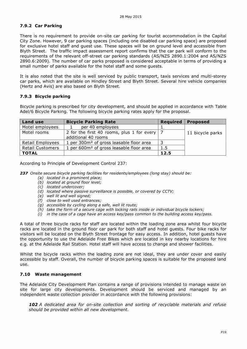
Bicycle parking is prescribed for city development, and should be applied in accordance with Table Adel/6 Bicycle Parking. The following bicycle parking rates apply for the proposal.
Land use Bicycle Parking Rate Required Proposed
Motel employees 1 per 40 employees 1 11 bicycle parks
Motel rooms 2 for the first 40 rooms, plus 1 for every additional 40 rooms
7
Retail Employees 1 per 300m² of gross leasable floor area 3 Retail Customers 1 per 600m² of gross leasable floor area 1.5 TOTAL 12.5
According to Principle of Development Control 237: 237 Onsite secure bicycle parking facilities for residents/employees (long stay) should be:
(a) located in a prominent place; (b) located at ground floor level; (c) located undercover; (d) located where passive surveillance is possible, or covered by CCTV; (e) well lit and well signed;
(f) close to well used entrances; (g) accessible by cycling along a safe, well lit route; (h) take the form of a secure cage with locking rails inside or individual bicycle lockers; (i) in the case of a cage have an access key/pass common to the building access key/pass.
A total of three bicycle racks for staff are located within the loading zone area whilst four bicycle racks are located in the ground floor car park for both staff and hotel guests. Four bike racks for visitors will be located on the Blyth Street frontage for easy access. In addition, hotel guests have the opportunity to use the Adelaide Free Bikes which are located in key nearby locations for hire e.g. at the Adelaide Rail Station. Hotel staff will have access to change and shower facilities. Whilst the bicycle racks within the loading zone are not ideal, they are under cover and easily accessible by staff. Overall, the number of bicycle parking spaces is suitable for the proposed land use.
7.10 Waste management
The Adelaide City Development Plan contains a range of provisions intended to manage waste on site for large city developments. Development should be serviced and managed by an independent waste collection provider in accordance with the following provisions:
102 A dedicated area for on-site collection and sorting of recyclable materials and refuse
should be provided within all new development.

28 May 2015
P20
103 A dedicated area for the collection and sorting of construction waste and the recycling of
building materials during construction as appropriate to the size and nature of the
development should be provided and screened from public view.
The applicant has submitted a waste management plan (by Foresight Environmental) as part of the application. The waste management plan details the nature of capture, storage and collection of waste from the site. A designated loading and refuse collection area is proposed to be located at the eastern end of the site within the existing right of way. This area will be able to accommodate the required 8.8m Medium Rigid Vehicle (MRV) provided by a private waste contractor. The proposed method of waste management and disposal (including traffic management for collection vehicles) has been considered by Council’s administration. No
objections are made in respect to the method of waste management and collection proposed for the development. 7.11 Acoustics
The application includes a noise impact statement by Wilkinson Murray (refer Attachments). The assessment considers potential noise impacts upon the building from existing noise sources within the locality as well as noise impacts from the development upon adjoining land and future occupants. The following noise provisions are relevant to the assessment:
O26 Development that does not unreasonably interfere with the desired character of the locality by generating unduly annoying or disturbing noise. 95 Noise sensitive development should incorporate adequate noise attenuation measures into their design and construction to provide occupants with reasonable amenity when exposed to noise sources such as major transport corridors (road, rail, tram and aircraft), commercial centres,
entertainment premises and the like, and from activities and land uses contemplated in the relevant Zone and Policy Area provisions.
96 Noise sensitive development in mixed use areas should not unreasonably interfere with the operation of surrounding non-residential uses that generate noise levels that are commensurate with the envisaged amenity of the locality.
No details of mechanical plant have been determined at this early stage of the project. Likely sources of mechanical noise from the proposed development will be the air-conditioning ventilation plant located on the roof. Therefore a condition is recommended to ensure that mechanical plant or equipment shall be designed, sited and screened to minimise noise impacts on adjacent premises and properties. The consultant on behalf of the applicant has concluded that, subject to recommended glazing and selection of plant and equipment within the building, the proposal can achieve the requirements of the Development Plan and Australian Standards.
7.12 Crime Prevention
The Development Plan promotes the use of appropriate design techniques to aid in minimising antisocial and criminal behaviour as sought by Council Wide PDC’s 83 to 87 and Objective 24.
O24: A safe and secure, crime resistant environment that: (a) ensures that land uses are integrated and designed to facilitate natural surveillance; (b) promotes building and site security; and (c) promotes visibility through the incorporation of clear lines of sight and appropriate
lighting.
(vi) use of robust and durable design features to discourage vandalism.
The applicant has commissioned a Crime Prevention through Environmental Design assessment report, prepared by The Planning Group NSW. This assessment involved seeking and
28 May 2015
P21
incorporating feedback from a Crime Prevention Sergeant from SAPOL. This proposed development will include the following safety and security measures:
Ground level retail tenancies, first floor terrace, and hotel windows above to maximise passive surveillance onto the public realm.
Clear glazing where practicable for the retail tenancies rather than solid walls to allow passive surveillance
The car park and loading dock entrance is widely configured to minimise concealment opportunities, and includes automatic panel security doors – only accessible via swipe cards.
The loading dock will be differentiated with treatment through the incorporation of a different pavement finish, contrasting to the surrounding lower ground floor.
Security lighting and CCTV cameras will be installed in key locations Access control through swipe card entry to all areas, including lifts. The planter box trees will be located to ensure no obstructions of slight lines from the
proposed entry points from Hindley Street and Blyth Street into the hotel, car park, loading area as well as adjacent development.
Although the hotel reception is on the first floor, the proposed retail ground floor space provides a level of casual surveillance to the porte cochere and building entrance. The glazed first floor facade facing Blyth Street provides the casual surveillance during evening hours. It is also likely that the hotel will use an intercom or require guests to use a swipe card to access the hotel’s
entrance after hours. A condition has been recommended seeking details for the lighting plan for the Blyth Street façade of the hotel. This is because the existing buildings have street lights attached to them which would be removed upon their demolition. It is important for Council to understand if any replacement street lighting will need to be installed. Good quality lighting along Blyth Street is essential to safety as well as ensuring CCTV footage can be captured. Overall, it is considered that appropriate opportunities for surveillance are designed into this proposed development. 7.13 Sustainability and stormwater management
The Development Plan contains a range of performance based provisions aimed at raising the standard of energy efficiency and sustainability for new urban development in the city. The applicant has supplied a Statement of Energy Efficiency, prepared by Cundall, as part of the development application. The hotel will comply with the requirements of the BCA Section J energy efficiency provisions through the following measures:
Energy efficient centralised air conditioning plant. Energy efficient lighting and lighting control systems. On-going operational management strategies for monitoring energy and water
consumption. External shading has been provided as required on the northwest, southeast and northeast elevations to restrict summer sun whilst permitting winter sun, however the western orientation is difficult to effectively shade. The Government Architect supports the southern hotel corridor having direct access to natural light but recommends that the northern corridor also does. However, as the building is built to the northern property boundary it means that no windows have been included on this façade for fire rating reasons. While several floors of the hotel would be above the height of the existing adjacent seven storey car park structure, this adjacent site might be redeveloped in the future. All of the hotel rooms have direct natural light and thus good access to natural light is achieved.
28 May 2015
P22
The applicant has also provided a Stormwater Management Plan by van der meet. This includes a preliminary erosion and sediment control plan to ensure that sediments and nutrients are contained on site during construction where possible. Council has advised that stormwater retention and reuse is not required for the development, including the car park as it is under 20 spaces in size.
7.14 Site contamination
The applicant has commissioned a Preliminary Site Investigation (PSI), by JBS&G, to determine if there are any potential site contamination issues associated with past and present site activities which may impact on its use as a hotel. This investigation identified that past printing/publishing related chemicals and the poor condition of the car park floor means that there is a potential for soil and ground water contamination in the northern portion of the site. Therefore, the PSI report recommends that intrusive site soil and groundwater investigations be undertaken at the site targeting the northern car park and access way portions to assess potential contaminant concentrations from historic site activities and potential adjacent activities groundwater impacts. This will be addressed via the condition requiring a Construction Management Plan. JBS&G have also undertaken a pre-demolition hazardous material survey as part of the developer’s due diligence process and this is included in the attachments. 7.15 Signage
The proposed signage for the Holiday Inn Express will be located on all facades of the building. ‘Blade’ signs will be located on the corner of Blyth Street and Hindley Street as well as on the Blyth Street to indicate the hotel entrance. Refer to ATTACHMENTS for details. In the Capital City Zone, the following guidance for signage is provided:
30 Other than signs along Hindley Street, advertisements should use simple graphics and be restrained in their size, design and colour. 31 In minor streets and laneways, a greater diversity of type, shape, numbers and design of advertisements are appropriate provided they are of a small-scale and located to present a consistent message band to pedestrians.
The proposed Holiday Inn Express Hotel signage will be situated below the top roof line and internally illuminated. The proposed signage is considered to be modest in scale and design and of relevant content. Overall, the proposed signage is considered appropriate and essential to guiding patrons to its entrance off Blyth Street.
8 CONCLUSION
The subject land is located in the Main Street Policy Area 14 of the Capital City Zone which seeks high scale land uses which aids the vitality of the area and encourages activities outside of retail hours. The proposal for a 10 level hotel with ground and first level retail spaces supports this intent. This development will also result in improvements to Blyth Street and has the potential to be a catalyst for the rejuvenation of the public realm in the West End of Adelaide as well as transform a currently dilapidated set of existing buildings. This hotel proposal is part of the international Holiday Inn Express Hotel chain which has a distinct corporate brand and identity which has strongly influenced the look and feel of the building. Although the Government Architect has raised recommendations in regards to refining the design and appearance of this building, these are not considered fundamental in relation to satisfying the Development Plan. As such, the proposal is considered to warrant a Development Plan Consent subject to conditions.
28 May 2015
P23
9. RECOMMENDATION
1) RESOLVE that the proposed development is NOT seriously at variance with the relevant
provisions of the Adelaide (City) Development Plan.
2) RESOLVE to grant Development Plan Consent to the proposal by Tactical Group for the ‘Demolition of existing buildings, installation of signage and construction of a 245 room accommodation hotel, retail spaces and hotel car park’ at 62 to 68 Hindley Street, Adelaide, subject to the following conditions:
IMDAC Planning Conditions
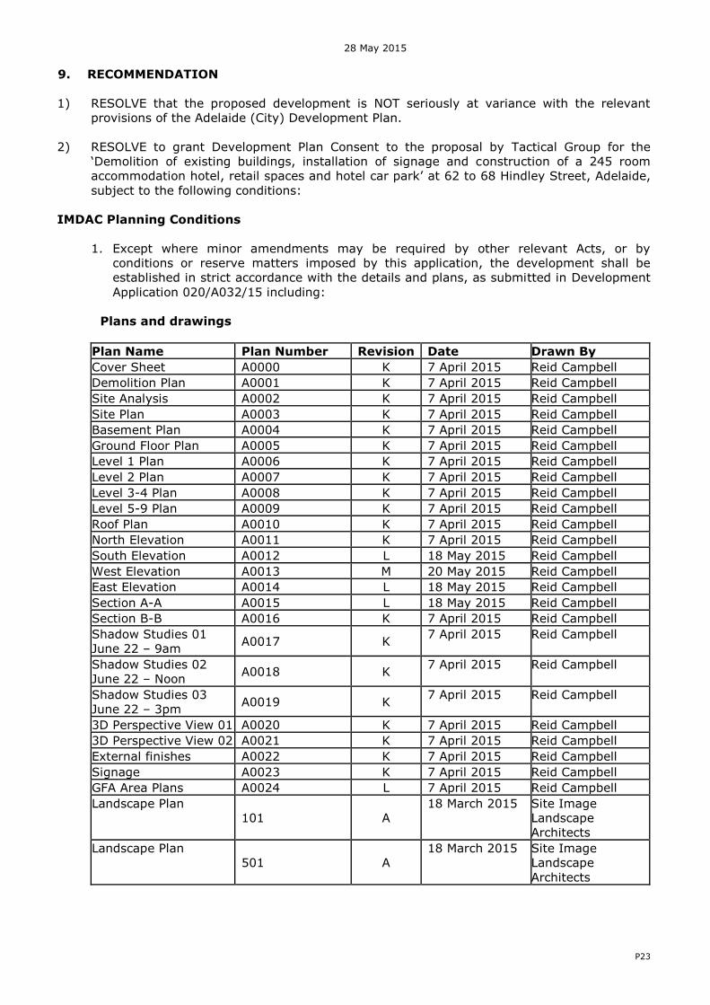
1. Except where minor amendments may be required by other relevant Acts, or by conditions or reserve matters imposed by this application, the development shall be established in strict accordance with the details and plans, as submitted in Development Application 020/A032/15 including:
Plans and drawings
Plan Name Plan Number Revision Date Drawn By
Cover Sheet A0000 K 7 April 2015 Reid Campbell Demolition Plan A0001 K 7 April 2015 Reid Campbell Site Analysis A0002 K 7 April 2015 Reid Campbell Site Plan A0003 K 7 April 2015 Reid Campbell Basement Plan A0004 K 7 April 2015 Reid Campbell Ground Floor Plan A0005 K 7 April 2015 Reid Campbell Level 1 Plan A0006 K 7 April 2015 Reid Campbell Level 2 Plan A0007 K 7 April 2015 Reid Campbell Level 3-4 Plan A0008 K 7 April 2015 Reid Campbell Level 5-9 Plan A0009 K 7 April 2015 Reid Campbell Roof Plan A0010 K 7 April 2015 Reid Campbell North Elevation A0011 K 7 April 2015 Reid Campbell South Elevation A0012 L 18 May 2015 Reid Campbell West Elevation A0013 M 20 May 2015 Reid Campbell East Elevation A0014 L 18 May 2015 Reid Campbell Section A-A A0015 L 18 May 2015 Reid Campbell Section B-B A0016 K 7 April 2015 Reid Campbell Shadow Studies 01 June 22 – 9am A0017 K 7 April 2015 Reid Campbell
Shadow Studies 02 June 22 – Noon A0018 K 7 April 2015 Reid Campbell
Shadow Studies 03 June 22 – 3pm A0019 K 7 April 2015 Reid Campbell
3D Perspective View 01 A0020 K 7 April 2015 Reid Campbell 3D Perspective View 02 A0021 K 7 April 2015 Reid Campbell External finishes A0022 K 7 April 2015 Reid Campbell Signage A0023 K 7 April 2015 Reid Campbell GFA Area Plans A0024 L 7 April 2015 Reid Campbell Landscape Plan
101 A 18 March 2015 Site Image
Landscape Architects
Landscape Plan 501 A
18 March 2015 Site Image Landscape Architects
28 May 2015
P24
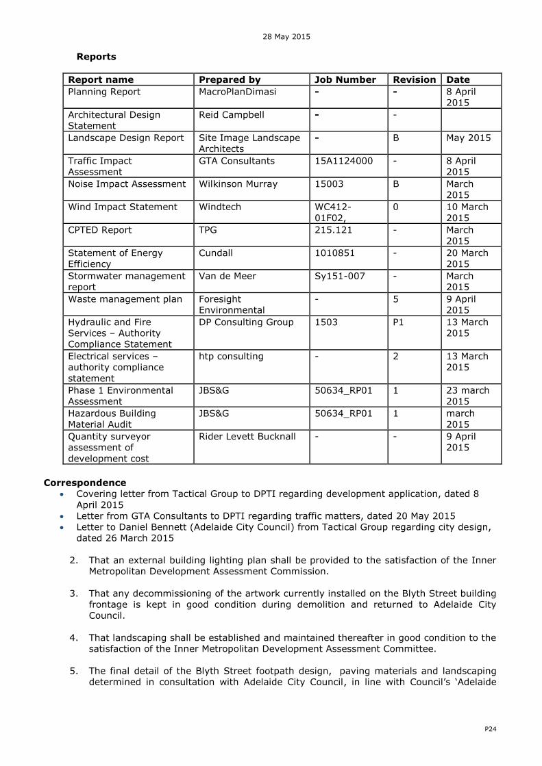
Reports
Report name Prepared by Job Number Revision Date
Planning Report MacroPlanDimasi - - 8 April 2015
Architectural Design Statement
Reid Campbell - -
Landscape Design Report Site Image Landscape Architects
- B May 2015
Traffic Impact Assessment
GTA Consultants 15A1124000 - 8 April 2015
Noise Impact Assessment Wilkinson Murray 15003 B March 2015
Wind Impact Statement Windtech WC412-01F02,
0 10 March 2015
CPTED Report TPG 215.121 - March 2015
Statement of Energy Efficiency
Cundall 1010851 - 20 March 2015
Stormwater management report
Van de Meer Sy151-007 - March 2015
Waste management plan Foresight Environmental
- 5 9 April 2015
Hydraulic and Fire Services – Authority Compliance Statement
DP Consulting Group 1503 P1 13 March 2015
Electrical services – authority compliance statement
htp consulting - 2 13 March 2015
Phase 1 Environmental Assessment
JBS&G 50634_RP01 1 23 march 2015
Hazardous Building Material Audit
JBS&G 50634_RP01 1 march 2015
Quantity surveyor assessment of development cost
Rider Levett Bucknall - - 9 April 2015
Correspondence
Covering letter from Tactical Group to DPTI regarding development application, dated 8 April 2015
Letter from GTA Consultants to DPTI regarding traffic matters, dated 20 May 2015 Letter to Daniel Bennett (Adelaide City Council) from Tactical Group regarding city design,
dated 26 March 2015
2. That an external building lighting plan shall be provided to the satisfaction of the Inner Metropolitan Development Assessment Commission.
3. That any decommissioning of the artwork currently installed on the Blyth Street building frontage is kept in good condition during demolition and returned to Adelaide City Council.
4. That landscaping shall be established and maintained thereafter in good condition to the
satisfaction of the Inner Metropolitan Development Assessment Committee.
5. The final detail of the Blyth Street footpath design, paving materials and landscaping determined in consultation with Adelaide City Council, in line with Council’s ‘Adelaide

28 May 2015
P25
Design Manual’ and to the satisfaction of the Inner Metropolitan Development
Commission, shall be provided prior to construction of the building.
6. A Construction Environment Management Plan (CEMP) shall be prepared and implemented in accordance with current industry standards – including the EPA publication “Environmental Management of On-site Remediation” - to minimise environmental harm and disturbance during construction. The plan must incorporate, without being limited to, the following matters:
- air quality, including odour and dust - surface water including erosion and sediment control - soils, including fill importation, stockpile management and prevention of soil
contamination - groundwater, including prevention of groundwater contamination noise - occupational health and safety
For further information relating to what Site Contamination is, refer to the EPA guideline Site Contamination – what is site contamination www.epa.sa.gov.au/pdfs/guide_sc_what.pdf A copy of the CEMP shall be provided to the both the Development Assessment Commission and the City of Adelaide prior to the commencement of site works.
7. All stormwater design and construction shall be in accordance with Australian Standards
and recognised engineering best practices to ensure that stormwater does not adversely affect any adjoining property or public road, to the satisfaction of the Development Assessment Commission.
8. Air conditioning plant and equipment shall be visually screened and noise attenuated in accordance with EPA standards, namely the Environment Protection (Noise) Policy 2007.
For further information refer to the EPA information sheet for noise level limits for fixed domestic machine noise. http://www.epa.sa.gov.au/xstd_files/Noise/Information%20sheet/info_noise_machine.pdf
9. External lighting of the site, including car parking areas and buildings, shall be
designed, located, shielded and constructed to conform to Australian Standards. Such lighting shall be operational during the hours of darkness to the reasonable satisfaction of the Development Assessment Commission.
10. The proposed car parking layout shall be designed and constructed to conform to the Australian Standard 2890.1:2004 for Off-Street Parking Facilities; Australian Standard
2890.6-2009 Parking facilities – Off street commercial vehicle facilities. 11. All bicycle facilities shall be designed and constructed in accordance with the Cycling
Aspects of Austroads Guides (2014) and AS2890.3-1993.
12. Mechanical plant or equipment, shall be designed, sited and screened to minimise noise impact on adjacent premises or properties. The noise level associated with the combined operation of plant and equipment such as air conditioning, ventilation and refrigeration systems when assessed at the nearest existing or envisaged noise sensitive location in or adjacent to the site shall not exceed:
55 dB(A) during daytime (7.00am to 10.00pm) and 45 dB(A) during night time
(10.00pm to 7.00am) when measured and adjusted in accordance with the relevant environmental noise legislation except where it can be demonstrated that a high background noise exists.
50 dB(A) during daytime (7.00am to 10.00pm) and 40 dB(A) during night time
(10.00pm to 7.00am) in or adjacent the Park Lands Zone when measured and

28 May 2015
P26
adjusted in accordance with the relevant environmental noise legislation except where it can be demonstrated that a high background noise exists.
13. All modifications required to Adelaide City Council’s public lighting and associated
infrastructure shall meet Councils’ requirements with all costs associated with these
works will be borne directly by the developer, unless otherwise agreed between the applicant and Council.
14. Prior to the commencement of construction, a dilapidation report (i.e. condition survey)
shall be prepared by a qualified engineer to ensure the stability and protection of adjoining buildings, structures and Council assets. A copy of this report shall be provided to Adelaide City Council and the Inner Metropolitan Development Assessment Commission.
IMDAC Advisory Notes
a) The applicant is reminded of its general environmental duty, as required by Section 25
of the Environment Protection Act 1993, to take all reasonable and practical measures to ensure that the activities on the whole site, including during construction, do not pollute the environment in a way which causes or may cause environmental harm. Any information sheets, guidelines documents, codes of practice, technical bulletins etc. that are referenced in this response can be accessed on the following web site: http://www.epa.sa.gov.au/pub.html
b) The applicant must ensure there is no objection from any of the public utilities in respect
of underground or overhead services and any alterations that may be required are to be at the applicant’s expense.
c) As work is being undertaken on or near the boundary, the applicant should ensure that
the boundaries are clearly defined, by a Licensed Surveyor, prior to the commencement of any building work.
d) The emission of noise from the premises is subject to control under the Environment
Protection Act and Regulations, 1993 and the applicant (or person with the benefit of this consent) should comply with those requirements.
e) Council approval is required before undertaking any works within the public realm.
f) The development must be substantially commenced within one (1) year of the date of
this Notification, unless this period has been extended by the Development Assessment Commission.
g) You are also advised that any act or work authorised or required by this Notification
must be completed within three (3) years of the date of the Notification unless this period is extended by the Commission.
h) The applicant will require a new consent before commencing or continuing the
development if you are unable to satisfy the conditions of approval.
i) Any request for an extension of time must be lodged with the Statutory Planning Branch, Department of Planning, Transport and Infrastructure, GPO Box 1815 Adelaide SA 5001, prior to the time periods specified.
j) The applicant has a right of appeal against the conditions which have been imposed on
this Development Plan Consent or Development Approval. Such an appeal must be lodged at the Environment, Resources and Development Court within two months of the day on which you receive this notice or such longer time as the Court may allow. Please

28 May 2015
P27
contact the Court if you wish to appeal. The Court is located in the Sir Samuel Way Building, Victoria Square, Adelaide, (telephone number 8204 0300).
…………………………………………………. Alison Collins
DEVELOPMENT DIVISION

28 May 2015
P28
APPENDIX A – Development Plan Provisions
CAPITAL CITY ZONE
Desired Character
This Zone is the economic and cultural focus of the State and includes a range of employment, community, educational, tourism and entertainment facilities. It is anticipated that an increased population within the Zone will complement the range of opportunities and experiences provided in the City and increase its vibrancy.
The Zone will be active during the day, evening and late night. Licensed entertainment premises, nightclubs and bars are encouraged throughout the Zone, particularly where they are located above or below ground floor level to maintain street level activation during the day and evening.
High-scale development is envisaged in the Zone with high street walls that frame the streets. However an interesting pedestrian environment and human scale will be created at ground floor levels through careful building articulation and fenestration, frequent openings in building façades, verandahs, balconies, awnings and other features that provide weather protection.
In important pedestrian areas, buildings will be set back at higher levels above the street wall to provide views to the sky and create a comfortable pedestrian environment. In narrow streets and laneways the street setback above the street wall may be relatively shallow or non-existent to create intimate spaces through a greater sense of enclosure. In the Central Business Policy Areas, upper level setbacks are not envisaged.
Non-residential land uses at ground floor level that generate high levels of pedestrian activity such as shops, cafés and restaurants will occur throughout the Zone. Within the Central Business Policy Area, residential land uses at ground level are discouraged. At ground level, development will continue to provide visual interest after hours by being well lit and having no external shutters.
There will also be a rich display of art that is accessible to the public and contextually relevant.
Exemplary and outstanding building design is desired in recognition of the location as South Australia’s capital. Contemporary juxtapositions will provide new settings for heritage places. Innovative forms are expected in areas of identified street character, referencing the past, but with emphasis on modern design-based responses that support optimal site development.
Adelaide’s pattern of streets and squares
The distinctive grid pattern of Adelaide will be reinforced through the creation of a series of attractive boulevards as shown on Concept Plan Figures CC/1 and 2. These boulevards will provide a clear sense of arrival into the City and be characterised by buildings that are aligned to the street pattern, particularly at ground level.
Views to important civic landmarks, the Park Lands and the Adelaide Hills will be retained as an important part of the City’s charm and character.
The City’s boulevards, terraces and Squares will be developed as follows:
(a) North Terrace will be reinforced as an important pedestrian promenade and cultural boulevard that provides an important northern edge to the City square mile.
(b) King William Street will be enhanced as the City’s principal north-south boulevard and will be reinforced as the City’s commercial spine.
(c) Grote Street-Wakefield Street will be enhanced as the City’s principal east-west boulevard and will be developed to provide a strong frame that presents a sense of enclosure to the street.
28 May 2015
P29
(d) East Terrace will be characterised by buildings that maximise views through to the Park Lands and provide a distinct City edge.
(e) West Terrace will be reinforced as the western ‘gateway’ to the City centre and will form an imposing frontage to the western City edge. Buildings will be constructed to the front and side boundaries, and designed to maximise views through to the Park Lands. Corner sites at the junctions of West Terrace and the major east-west streets will be developed as strongly defined visual gateways to the City. This will provide an imposing frontage to the western edge of the City, which comprises a mixture of commercial, showroom and residential development.
(f) Pulteney and Morphett streets are key north-south boulevards. A sense of activation and enclosure of these streets will be enhanced through mixed use development with a strong built form edge. Pulteney Street will include residential, office and institutional uses, and retail activities. These boulevards will become important tree-lined commercial corridors.
(g) Currie, Grenfell, Franklin and Flinders streets, as wider east-west boulevards provide important entry points to the City. Currie and Grenfell streets will become a key focus for pedestrians, cycling and public transport. These streets also provide long views to the hills as their closing vistas and these view corridors should remain uncluttered.
(h) Victoria, Hindmarsh and Light Squares will have a continuous edge of medium to high-scale development that frames the Squares and increases ground level activity.
The Zone also includes a number of Main Street areas, encompassing Rundle Mall, Rundle Street, Hindley Street and Gouger Street, which are envisaged to have a wide range of retail, commercial and community uses that generate high levels of activity. These areas will have an intimately scaled built form with narrow and frequent building frontages. These areas are shown on Concept Plan Figures CC/1 and 2.
Minor streets and laneways will have a sense of enclosure (a tall street wall compared to street width) and an intimate, welcoming and comfortable pedestrian environment with buildings sited and composed in a way that responds to the buildings’ context. There will be a strong emphasis on ground level activation through frequent window openings, land uses that spill out onto the footpath, and control of wind impacts.
Development in minor streets and laneways with a high value character will respond to important character elements and provide a comfortable pedestrian environment, particularly in the following streets: Gray, Leigh, Union, Chesser, Coromandel, Tucker, Cardwell, Kenton, Market, Ruthven, Cannon, Tatham, Benthem streets, Murrays Lane and Wright Court.
A comprehensive, safe and convenient movement network throughout the City will develop, focusing on the provision of linkages on both public and private land between important destinations and public transport. A high quality system of bicycle or shared pedestrian and bicycle routes will be established within the Zone.
OBJECTIVES
General
Objective 1: The principal focus for the economic, social and political life of metropolitan Adelaide and the State.
Objective 2: A vibrant mix of commercial, retail, professional services, hospitality, entertainment, educational facilities, and medium and high density living.
Objective 3: Design and management of City living to ensure the compatibility of residential amenity with the essential commercial and leisure functions of the Zone.
Objective 4: City streets that provide a comfortable pedestrian environment.
28 May 2015
P30
Objective 5: Innovative design approaches and contemporary architecture that respond to a building’s context.
Objective 6: Buildings that reinforce the gridded layout of Adelaide’s streets and respond to the underlying built-form framework of the City.
Objective 7: Large sites developed to their full potential while ensuring a cohesive scale of development and responding to a building’s context.
Objective 8: Development that contributes to the Desired Character of the Zone.
PRINCIPLES OF DEVELOPMENT CONTROL
Land Use
1 The following types of development, or combinations thereof, are envisaged: Affordable housing Aged persons accommodation Community centre Consulting room Convention centre Dwelling Educational establishment Emergency services facility Hospital Hotel Indoor recreation centre Licensed entertainment premises Library Motel Office Pre-school Personal service establishment Place of worship Serviced apartment Restaurant Residential flat building Student accommodation Shop or group of shops Tourist accommodation 2 Land uses that are typically closed during the day should be designed to maximise daytime and evening activation at street level and be compatible with surrounding land uses, in particular residential development.
3 Low impact industries should be located outside the Central Business Policy Area and have minimal off-site impacts with respect to noise, air, water and waste emissions, traffic generation and movement.
4 Development listed as non-complying is generally inappropriate.
Form and Character
5 Development should be consistent with the Desired Character for the Zone.
Design and Appearance
6 Development should be of a high standard of architectural design and finish which is appropriate to the City’s role and image as the capital of the State.
28 May 2015
P31
7 Buildings should present an attractive pedestrian-oriented frontage that adds interest and vitality to City streets and laneways.
8 The finished ground floor level of buildings should be at grade and/or level with the footpath to provide direct pedestrian access and street level activation.
9 Providing footpath widths and street tree growth permit, development should contribute to the comfort of pedestrians through the incorporation of verandahs, balconies, awnings and/or canopies that provide pedestrian shelter.
10 Buildings should be positioned regularly on the site and built to the street frontage, except where a setback is required to accommodate outdoor dining or provide a contextual response to a heritage place.
11 Other than in the Central Business Policy Area, buildings should be designed to include a podium/street wall height and upper level setback (in the order of 3-6 metres) that:
(a) relates to the width of the street and achieves a suitable level of enclosure to the public realm;
(b) provides a human scale at street level;
(c) creates a well-defined and continuity of frontage;
(d) gives emphasis and definition to street corners to clearly define the street grid;
(e) contributes to the interest, vitality and security of the pedestrian environment;
(f) maintains a sense of openness to the sky for pedestrians and brings daylight to the street; and
(g) achieves pedestrian comfort by minimising micro climatic impacts (particularly wind tunnelling and downward drafts).
12 Buildings north of Rundle Mall, Rundle Street, Hindley Street and Gouger Street should have a built form that incorporates slender tower elements, spaces between buildings or other design techniques that enable sunlight access to the southern footpath.
13 Buildings, advertisements, site landscaping, street planting and paving should have an integrated, coordinated appearance and should enhance the urban environment.
14 Building façades should be strongly modelled, incorporate a vertical composition which reflects the proportions of existing frontages, and ensure that architectural detailing is consistent around corners and along minor streets and laneways.
The Squares (Victoria, Hindmarsh and Light)
15 Outdoor eating and drinking facilities associated with cafés and restaurants are appropriate ground floor uses and should contribute to the vitality of the Squares and create a focus for leisure.
16 Buildings fronting the Squares should:
(a) provide a comfortable pedestrian and recreation environment by enabling direct sunlight to a minimum of 75 percent of the landscaped part of each Square at the September equinox; and
(b) reinforce the enclosure of the Squares with a continuous built-form with no upper level set-backs.
28 May 2015
P32
The Terraces (North, East and West)
17 Development along the terraces should contribute to a continuous built form to frame the City edge and activate the Park Lands.
18 Development along North Terrace should reinforce the predominant scale and ‘City wall’ character of the Terrace frontage.
Building Height
19 Development should generally be compatible with the overall desired city form and not exceed the maximum building height shown in Concept Plan Figures CC/1 and 2; unless it meets one or more of the following:
(a) the proposed building is located in one of the following areas:
(i) fronting North Terrace, West Terrace or East Terrace and/or at the junction of two City boulevards shown in Concept Plan Figures CC/1 and 2;
(ii) on an allotment with frontage to Light Square;
(iii) within 200 metres of a high concentration public transport route identified on Map Adel/1 (Overlay 4);
(b) the site area is greater than 1500 square metres and has side or rear vehicle access;
(c) the development provides an orderly transition up to an existing taller building or prescribed maximum building height in an adjoining Zone or Policy Area;
(d) the proposal incorporates the retention and conservation of a character building.
20 Development should have optimal height and floor space yields to take advantage of the premium City location and should have a building height no less than half the maximum shown on Concept Plan Figures CC/1 and 2, or 28 metres in the Central Business Policy Area, except where one or more of the following applies:
(a) a lower building height is necessary to achieve compliance with the Commonwealth Airports (Protection of Airspace) Regulations;
(b) the site is adjacent to the City Living Zone or the Adelaide Historic (Conservation) Zone and a lesser building height is required to manage the interface with low-rise residential development;
(c) the site is adjacent to a heritage place, or includes a heritage place;
(d) the development includes the construction of a building in the same, or substantially the same, position as a building which was demolished, as a result of significant damage caused by an event, within the previous 3 years where the new building has the same, or substantially the same, layout and external appearance as the previous building.
Interface
21 Development should manage the interface with the City Living Zone or the Adelaide Historic (Conservation) Zone in relation to building height, overshadowing, massing, building proportions and traffic impacts and should avoid land uses, or intensity of land uses, that adversely affect residential amenity.
22 Development on all sites on the southern side of Gouger Street - Angas Street and adjacent to a northern boundary of the City Living Zone or the Adelaide Historic (Conservation) Zone should not exceed 22 metres in building height unless the Council Wide overshadowing Principles of Development Control are met.
28 May 2015
P33
Movement
23 Pedestrian movement should be based on a network of pedestrian malls, arcades and lanes, linking the surrounding Zones and giving a variety of north-south and east-west links.
24 Development should provide pedestrian linkages for safe and convenient movement with arcades and lanes clearly designated and well-lit to encourage pedestrian access to public transport and areas of activity. Blank surfaces, shutters and solid infills lining such routes should be avoided.
25 Development should ensure existing through-site and on-street pedestrian links are maintained and new pedestrian links are developed in accordance with Map Adel/1 (Overlay 2A).
26 Car parking should be provided in accordance with Table Adel/7.
27 Multi-level car parks should locate vehicle access points away from the primary street frontage wherever possible and should not be located:
(a) within any of the following areas:
(i) the Core Pedestrian Area identified in Map Adel/1 (Overlays 2, 2A and 3)
(ii) on frontages to North Terrace, East Terrace, Rundle Street, Hindley Street, Currie Street, Waymouth Street (east of Light Square), Victoria Square or King William Street;
(b) where they conflict with existing or projected pedestrian movement and/or activity;
(c) where they would cause undue disruption to traffic flow; and
(d) where it involves creating new crossovers in North Terrace, Rundle Street, Hindley Street, Currie Street and Waymouth Street (east of Light Square), Grenfell Street and Pirie Street (west of Pulteney Street), Victoria Square, Light Square, Hindmarsh Square, Gawler Place and King William Street or access across primary City access and secondary City access roads identified in Map Adel/1 (Overlay 1).
28 Multi-level, non-ancillary car parks are inappropriate within the Core Pedestrian Area as shown on Map Adel/1 (Overlays 2, 2A and 3).
29 Vehicle parking spaces and multi-level vehicle parking structures within buildings should:
(a) enhance active street frontages by providing land uses such as commercial, retail or other non-car park uses along ground floor street frontages;
(b) complement the surrounding built form in terms of height, massing and scale; and
(c) incorporate façade treatments along major street frontages that are sufficiently enclosed and detailed to complement neighbouring buildings consistent with the Desired Character of the locality
Advertising
30 Other than signs along Hindley Street, advertisements should use simple graphics and be restrained in their size, design and colour.
31 In minor streets and laneways, a greater diversity of type, shape, numbers and design of advertisements are appropriate provided they are of a small-scale and located to present a consistent message band to pedestrians.
32 There should be an overall consistency achieved by advertisements along individual street frontages.

28 May 2015
P34
33 In Chesser Street, French Street and Coromandel Place advertisements should be small and preferably square and should not be located more than 3.7 metres above natural ground level or an abutting footpath or street. However, advertisements in these streets may be considered above 3.7 metres at locations near the intersections with major streets.
34 Advertisements on the Currie Street frontages between Topham Mall and Gilbert Place and its north-south prolongation should be of a size, shape and location complementary to the desired townscape character, with particular regard to the following:
(a) On the southern side of Currie Street, advertisements should be fixed with their underside at a common height, except where the architectural detailing of building façades precludes it. At this ‘canopy’ level advertisements should be of a uniform size and fixed without the support of guy wires. Where architectural detailing permits, advertisements may mark the major entrances to buildings along the southern side of Currie Street with vertical projecting advertisements 1.5 metres high by 1.2 metres wide at, or marginally above, the existing canopy level. Painted wall or window signs should be restrained.
(b) On the northern side of Currie Street, advertisements should be of a uniform fixing height and consistent dimensions to match those prevailing in the area.
PROCEDURAL MATTERS
Complying Development
35 Complying developments are prescribed in Schedule 4 of the Development Regulations 2008.
In addition, the following forms of development are assigned as complying:
(a) Other than in relation to a State heritage place, Local heritage place (City Significance), or Local heritage place, work undertaken within a building which does not involve a change of use or affect the external appearance of the building;
(b) Temporary depot for Council for a period of no more than 3 months where it can be demonstrated that appropriate provision has been made for:
(i) dust control;
(ii) screening, including landscaping;
(iii) containment of litter and water; and
(iv) securing of the site.
(c) Change in the use of land from a non-residential use to an office, shop or consulting room (excluding any retail showroom, adult entertainment premises, adult products and services premises or licensed premises).
Non-complying Development
36 The following kinds of development are non-complying:
A change in use of land to any of the following:
Amusement machine centre
Advertisements involving any of the following:
(a) Third party advertising except on Hindley Street, Rundle Mall or on allotments at the intersection of Rundle Street and Pulteney Street frontages (except where fronting King William Street), or temporary advertisements on construction sites;
(b) Advertisements located at roof level where the sky or another building forms the background when viewed from ground level;
28 May 2015
P35
(c) Advertisements in the area bounded by West Terrace, Grote Street, Franklin Street and Gray Street;
(d) Animation of advertisements along and adjacent to the North Terrace, King William Street and Victoria Square frontages.
Demolition of a State heritage place (as identified in Table Adel/1)
Vehicle parking except:
(a) where it is ancillary to an approved or existing use;
(b) it is a multi-level car park located outside the Core Pedestrian Area as indicated on Map Adel/1 (Overlay 2, 2A and 3); or
(c) it is within an existing building located outside the Core Pedestrian Area as indicated on Map Adel/1 (Overlay 2, 2A and 3).
Public Notification
37 Categories of public notification are prescribed in Schedule 9 of the Development Regulations 2008.
In addition, the following forms of development, or any combination of (except where the development is non-complying), are assigned:
(a) Category 1, public notification not required:
All forms of development other than where it is assigned Category 2.
(b) Category 2, public notification required. Third parties do not have any appeal rights.
Any development where the site of the development is adjacent land to land in a Residential Zone and it exceeds 22 metres in building height.
Note: For Category 3 development, public notification is required. Third parties may make written
representations, appear before the relevant authority on the matter, and may appeal against a
development consent. This includes any development not classified as either Category 1 or
Category 2.

28 May 2015
P36
Main Street Policy Area 14
Introduction
The Objectives and Principles of Development Control that follow apply to the Policy Area as shown on Maps Adel/48, 49, 50, 51 and 55. They are additional to those expressed for the Zone and, in cases of apparent conflict, take precedence over the Zone provisions. In the assessment of development, the greatest weight is to be applied to satisfying the Desired Character for the Policy Area.
Desired Character
Main streets provide an important shopping, hospitality and gathering place that are a vital part of the City’s identity and image. An atmosphere of bustle, excitement and activity is created by a vibrant mixture of land uses that support a strong retail base and a continuing program of on-street arts and activities. Activities including retail, restaurants, cafés and licensed premises will contribute to the day and evening economies and be managed to ensure a positive contribution to the character of the precinct. Licensed entertainment premises, nightclubs and bars will contribute to activation during the day and evening by generally being small in scale and located above or below ground floor level. Development will abut the footpath and continue the established width, rhythm and pattern of façades to generally support a variety of tenancies with narrow frontages. Horizontally massed buildings will be broken into smaller façade elements. Above street level fenestration, balconies, parapets, architectural detailing and ornamentation will be used to contribute to a rich visual texture. Upper levels of buildings are to be recessed behind a moderately scaled building street wall to maintain a sense of spaciousness and openness to the sky. At lower levels, the continuity of verandahs and other canopies or pedestrian shelters, and ceiling heights is desired to maintain a sheltered, high amenity pedestrian environment at a human scale. Rundle Street Development will be consistent with the intimate scale and intricate and diverse architectural features of Rundle Street and will reinforce the existing two and three storey built scale. This is derived from buildings of relatively uniform height and scale, mostly built in the nineteenth and early twentieth century. Existing façades typically encompass a high proportion of solid to void and a high level of architectural detail (including ornamentation and fenestration and through a combination of materials). Horizontal emphasis is achieved through the integration of masonry coursing, parapets, verandahs and balconies. The subtle variety of scale and massing adds texture to the streetscape. Upper levels of buildings are to be recessed to maintain a sense of spaciousness and openness to the sky. Rundle Mall
Rundle Mall will be enhanced as Adelaide’s premier retail area incorporating a wide range of
specialty and larger scale shops and mixed business. Rundle Mall will continue to grow and evolve in response to the needs of the retail and business sectors and the wider public, and enhance its iconic reputation as an important public space for a range of retail, business and cultural purposes. A range of activities will contribute to the day and evening economies.

28 May 2015
P37
Rundle Mall offers a strong and unique character and sense of place, established by a pedestrian space framed by a long enclosure of visual interest and vitality which is reached with a sense of arrival from King William Street and Pulteney Street and the adjoining minor streets, arcades and laneways. Hindley Street
Hindley Street (east of Morphett Street) will be the City’s focus for late night entertainment and
will be carefully designed and managed to integrate effectively with day time and evening land use activities. Hindley Street (west of Morphett Street) will comprise a range of mixed business, educational, cultural, hospitality and retail activities. Activities, including licensed premises, will contribute to the day and evening economies. The refurbishment of nineteenth century buildings in Hindley Street will be complemented by sensitive new development and will provide a colourful and cohesive character and intimate, human scale. Gouger Street
Gouger Street will be characterised by a mix of retail, restaurant, commercial and mixed business uses, including professional services, wholesaling and community activities. Activities including restaurants, cafés and licensed premises will contribute to the vibrancy of the street during the day and evening. Gouger and Grote streets will continue to develop as a colourful and active restaurant and shopping precinct which complements the liveliness of the Central Market and supports the retail, community, cultural and legal functions in this part of the City. ‘Chinatown’ around Moonta Street will be reinforced, and opportunities for new precincts, such as in minor streets and lanes, established. OBJECTIVES
Objective 1: Rundle Street enhanced as an important shopping, leisure and gathering place for metropolitan Adelaide. Objective 2: Rundle Mall enhanced as the State’s premier shopping destination around an
attractive public space. Objective 3: Hindley Street (east of Morphett Street) as the pre-eminent evening and late night entertainment hub for metropolitan Adelaide, with complementary shopping, hospitality and mixed business together with high density living. Objective 4: Hindley Street (west of Morphett Street) reinforced as a main street with a mix of retail, educational, restaurant and business uses, together with high density living. Objective 5: Gouger Street reinforced as a colourful, intimate and active restaurant and shopping street which complements the vibrancy of the Central Market and supports the retail, community and cultural functions of the area. Objective 6: Development that contributes to the Desired Character of the Policy Area.
28 May 2015
P38
PRINCIPLES OF DEVELOPMENT CONTROL
Land Use
1 At ground level along any main street (including Rundle Mall) and in minor streets leading to them, development should provide active and vibrant frontages that contribute to continuous interest at street level. 2 Land uses that add to the vitality of the area and extend activities outside shop hours are envisaged, including restaurants; educational, community and cultural facilities; and visitor and residential accommodation. 3 To enable an activated street level, residential development or similar should be located above ground floor level. 4 Licensed entertainment premises, night clubs or bars should contribute to activation during the day and evening by generally being small in scale and located above or below ground floor level. Design and Appearance
5 The ground level street frontage of buildings should be designed as activate street frontages, provide pedestrian interest, and maximise passive surveillance by: (a) providing at least 70 percent of the frontage as a non-residential use; and (b) 50 percent of the frontage as visually permeable, transparent or clear glazed and may include an entry/foyer or display window to a shop (including a café or restaurant).
Form and Character
6 Development should conserve, enhance and complement the colourful and visually rich and intimate character of the area.
7 Development should include a variety of architectural expression and finishes compatible with the many existing older buildings. Verandahs, balconies, awnings and parapets should be designed to complement those existing.
8 Development should strengthen the established character of narrow building frontage widths, vertical massing and above street level fenestrations, balconies, parapets, architectural detailing and ornamentation.
9 Buildings with frontage to Gouger Street, Hindley Street or Rundle Street, west of Frome Street, should be designed to: (a) reinforce the prevailing datum heights and parapet levels of the street through design elements that provide a clear distinction between levels above and below the prevailing datum line; and (b) include a maximum podium/street wall height in the order of six storeys, with an upper level setback, measured from the street wall in the order of 3 metres.
10 Buildings with frontage to Rundle Mall should have a maximum podium/street wall height of 6 storeys with upper building levels set back from the street in the order of 3 metres.
11 Buildings with frontage to Rundle Street, east of Frome Street should be designed to reinforce the prevailing datum heights and parapet levels of the street through: (a) a maximum podium/street wall height that is consistent with one of the adjacent buildings facing the street and does not exceed 13 metres; (b) an upper level setback, measured from the street wall, of at least 3 metres stepping up to a height of 6 storeys, then a further setback of at least 3 metres stepping up to the maximum overall height shown on Concept Plan Figures CC/1 and 2; and (c) design elements that create a clear distinction between the 13 metre and 22 metre datum lines.
28 May 2015
P39
12 Development of both internal and external spaces on Rundle Street should maintain an environment which is intimately scaled, intricate and diverse.
Movement
13 Additional vehicle cross-overs to provide access should be avoided in Hindley Street, Bank Street and Leigh Street. Access for on-site servicing and deliveries should be from minor streets and private lanes wherever possible, rather than from Rundle Mall.
14 Pedestrian movement should be based on a network of pedestrian malls, arcades and lanes, linking the surrounding areas and giving a variety of north to south routes to Rundle Mall and east to west links for people moving between buildings.
COUNCIL WIDE
City Living
Housing Choice
Objective 6: A variety of housing options which supplement existing types of housing and suit
the widely differing social, cultural and economic needs of all existing and future
residents.
Objective 7: A range of long and short term residential opportunities to increase the number and
range of dwellings available whilst protecting identified areas of special character
and improving the quality of the residential environment.
Objective 8: A broad range of accommodation to meet the needs of low income, disadvantaged
and groups with complex needs whilst ensuring integration with existing residential
communities.
5 Development should comprise of a range of housing types, tenures and cost, to meet the
widely differing social and economic needs of residents.
6 Development should provide a variety of accommodation to meet the needs of low income
people, student housing, social housing, housing for single people, large and small
families, people with disabilities and people with other complex needs. These forms of
housing should be distributed throughout the Council area to avoid over-concentration of
similar types of housing in a particular area and should be of a scale and appearance that
reinforces and achieves the desired character of the locality, as expressed in the relevant
Zone and Policy Area.
7 Residential development should be designed to be adaptable to meet people’s needs
throughout their lifespan to ensure that changes associated with old age, special access
and mobility can be accommodated.
Environmental
Crime Prevention Through Urban Design
Objective 24: A safe and secure, crime resistant environment that:
(a) ensures that land uses are integrated and designed to facilitate natural
surveillance;
(b) promotes building and site security; and
(c) promotes visibility through the incorporation of clear lines of sight and
appropriate lighting.

28 May 2015
P40
83 Development should promote the safety and security of the community in the public realm
and within development. Development should:
(a) promote natural surveillance of the public realm, including open space, car parks,
pedestrian routes, service lanes, public transport stops and residential areas, through
the design and location of physical features, electrical and mechanical devices,
activities and people to maximise visibility by:
(i) orientating windows, doors and building entrances towards the street, open
spaces, car parks, pedestrian routes and public transport stops;
(ii) avoiding high walls, blank facades, carports and landscaping that obscures direct
views to public areas
(iii) arranging living areas, windows, pedestrian paths and balconies to overlook
recreation areas, entrances and car parks;
(iv) positioning recreational and public space areas so they are bound by roads on at
least two road frontages or overlooked by development;
(v) creating a complementary mix of day and night-time activities, such as
residential, commercial, recreational and community uses, that extend the
duration and level of intensity of public activity;
(vi) locating public toilets, telephones and other public facilities with direct access and
good visibility from well-trafficked public spaces;
(vii) ensuring that rear service areas and access lanes are either secured or exposed
to surveillance; and
(viii) ensuring the surveillance of isolated locations through the use of audio monitors,
emergency telephones or alarms, video cameras or staff eg by surveillance of lift
and toilet areas within car parks.
(b) provide access control by facilitating communication, escape and path finding within
development through legible design by:
(i) incorporating clear directional devices;
(ii) avoiding opportunities for concealment near well travelled routes;
(iii) closing off or locking areas during off-peak hours, such as stairwells, to
concentrate access/exit points to a particular route;
(iv) use of devices such as stainless steel mirrors where a passage has a bend;
(v) locating main entrances and exits at the front of a site and in view of a street;
(vi) providing open space and pedestrian routes which are clearly defined and have
clear and direct sightlines for the users; and
(vii) locating elevators and stairwells where they can be viewed by a maximum
number of people, near the edge of buildings where there is a glass wall at the
entrance.
(c) promote territoriality or sense of ownership through physical features that express
ownership and control over the environment and provide a clear delineation of public
and private space by:
(i) clear delineation of boundaries marking public, private and semi-private space,
such as by paving, lighting, walls and planting;
(ii) dividing large development sites into territorial zones to create a sense of
ownership of common space by smaller groups of dwellings; and
(iii) locating main entrances and exits at the front of a site and in view of a street.
(d) provide awareness through design of what is around and what is ahead so that
legitimate users and observers can make an accurate assessment of the safety of a
locality and site and plan their behaviour accordingly by:
(i) avoiding blind sharp corners, pillars, tall solid fences and a sudden change in grade
of pathways, stairs or corridors so that movement can be predicted;
(ii) using devices such as convex security mirrors or reflective surfaces where lines of
sight are impeded;
(iii) ensuring barriers along pathways such as landscaping, fencing and walls are
permeable;
28 May 2015
P41
(iv) planting shrubs that have a mature height less than one metre and trees with a
canopy that begins at two metres;
(v) adequate and consistent lighting of open spaces, building entrances, parking and
pedestrian areas to avoid the creation of shadowed areas; and
(vi) use of robust and durable design features to discourage vandalism.
84 Residential development should be designed to overlook streets, public and communal
open space to allow casual surveillance.
85 To maximise security and safety, buildings should be designed to minimise access between
roofs, balconies and windows of adjacent buildings.
86 Security features should be incorporated within the design of shop fronts to complement
the design of the frontage and allow window shopping out of hours. If security grilles are
provided, these should:
(a) be transparent and illuminated to complement the appearance of the frontage;
(b) provide for window shopping; and
(c) allow for the spill of light from the shop front onto the street.
Solid shutters with less than 75 percent permeability are not acceptable.
Noise Emissions
Objective 26: Development that does not unreasonably interfere with the desired character of
the locality by generating unduly annoying or disturbing noise.
Objective 27: Noise sensitive development designed to protect its occupants from existing
noise sources and from noise sources contemplated within the relevant Zone or
Policy Area and that does not unreasonably interfere with the operation of
nonresidential uses contemplated within the relevant Zone or Policy Area.
Noise Sources
90 Development with potential to emit significant noise (including licensed entertainment
premises and licensed premises) should incorporate appropriate noise attenuation
measures in to their design to prevent noise from causing unreasonable interference with
the amenity and desired character of the locality, as contemplated in the relevant Zone
and Policy Area.
92 Development of licensed premises or licensed entertainment premises or similar in the
Capital City, Main Street and City Frame Zones should include noise attenuation measures
to achieve the following when assessed at:
(a) the nearest existing noise sensitive location in or adjacent to that Zone:
(i) music noise (L10, 15 min) less than 8 dB above the level of background noise
(L90,15 min) in any octave band of the sound spectrum; and (ii) music noise (LA10, 15
min) less than 5 dB(A) above the level of background noise (LA90,15 min) for the
overall (sum of all octave bands) A-weighted levels; or
(b) the nearest envisaged future noise sensitive location in or adjacent to that Zone:
(i) music noise (L10, 15 min) less than 8dB above the level of background noise
(L90,15 min) in any octave band of the sound spectrum and music noise (L10, 15
min) less than 5dB(A) above the level of background noise (LA90,15 min) for the
overall (sum of all octave bands) A-weighted levels; or
(ii) music noise (L10, 15 min) less than 60dB(Lin) in any octave band of the sound
spectrum and the overall (LA10,15 min) noise level is less than 55 dB(A).
28 May 2015
P42
93 Speakers should not be placed on the fascias of premises or on the pavement adjacent to
the premises to ensure development does not diminish the enjoyment of other land in the
locality.
94 Mechanical plant or equipment, should be designed, sited and screened to minimise noise
impact on adjacent premises or properties. The noise level associated with the combined
operation of plant and equipment such as air conditioning, ventilation and refrigeration
systems when assessed at the nearest existing or envisaged noise sensitive location in or
adjacent to the site should not exceed:
(a) 55 dB(A) during daytime (7.00am to 10.00pm) and 45 dB(A) during night time
(10.00pm to 7.00am) when measured and adjusted in accordance with the relevant
environmental noise legislation except where it can be demonstrated that a high
background noise exists.
(b) 50 dB(A) during daytime (7.00am to 10.00pm) and 40 dB(A) during night time
(10.00pm to 7.00am) in or adjacent to a Residential Zone, the North Adelaide Historic
(Conservation) Zone or the Park Lands Zone when measured and adjusted in
accordance with the relevant environmental noise legislation except where it can be
demonstrated that a high background noise exists.
95 To ensure minimal disturbance to residents:
(a) ancillary activities such as deliveries, collection, movement of private waste bins,
goods, empty bottles and the like should not occur:
(i) after 10.00pm; and
(ii) before 7.00am Monday to Saturday or before 9.00am on a Sunday or Public
Holiday.
(b) typical activity within any car park area including vehicles being started, doors closing
and vehicles moving away from the premises should not result in sleep disturbance
when proposed for use after 10.00pm as defined by the limits recommended by the
World Health Organisation.
Noise Receivers
96 Noise sensitive development should incorporate adequate noise attenuation measures into
their design and construction to provide occupants with reasonable amenity when exposed
to noise sources such as major transport corridors (road, rail, tram and aircraft),
commercial centres, entertainment premises and the like, and from activities and land
uses contemplated in the relevant Zone and Policy Area provisions.
97 Noise sensitive development in mixed use areas should not unreasonably interfere with the
operation of surrounding non-residential uses that generate noise levels that are
commensurate with the envisaged amenity of the locality.
98 Noise sensitive development adjacent to noise sources should include noise attenuation
measures to achieve the following:
(a) satisfaction of the sleep disturbance criteria in the bedrooms or sleeping areas of the
development as defined by the limits recommended by the World Health Organisation;
(b) the maximum satisfactory levels in any habitable room for development near major
roads, as provided in the Australian/New Zealand Standard AS/NZS 2107:2000 -
‘Acoustics - Recommended Design Sound Levels and Reverberation Times for Building
Interiors’; and
(c) noise level in any bedroom, when exposed to music noise (L10) from existing
entertainment premises, being:
(i) less than 8 dB above the level of background noise (L90,15 min) in any octave band
of the sound spectrum; and
(ii) less than 5 dB(A) above the level of background noise (LA90,15 min) for the overall
(sum of all octave bands) A-weighted levels.

28 May 2015
P43
Background noise within the habitable room can be taken to be that expected in a typical
residential/apartment development of the type proposed, that is inclusive of internal noise
sources such as air conditioning systems, refrigerators and the like as deemed
appropriate.
Unless otherwise demonstrated, the minimum background noise to be used will be:
Octave Band Centre Frequency(Hz) Minimum Background Noise Level (LA90,
15) dB (A)
63 10
125 12
250 14
500 14
1000 12
2000 10
4000 8
Overall Sum 21
on the basis of the windows being closed for the noise sensitive development and any
existing entertainment premises complying with the relevant legislation relating to noise
emission
99 Attached dwellings/serviced apartments should be designed to minimise the transmission
of sound between dwellings/serviced apartments and should particularly protect bedrooms
from possible noise intrusion.
100 The number of dwellings/serviced apartments within a development sharing a common
entry should be minimised to limit noise generation in internal access ways.
Waste Management
Objective 28: Development which supports high local environmental quality, promotes waste
minimisation, re-use and recycling, encourages waste water, grey water and
stormwater re-use and does not generate unacceptable levels of air, liquid or
solid pollution.
102 A dedicated area for on-site collection and sorting of recyclable materials and refuse
should be provided within all new development.
103 A dedicated area for the collection and sorting of construction waste and the recycling of
building materials during construction as appropriate to the size and nature of the
development should be provided and screened from public view.
104 Development greater than 2 000 square metres of total floor area should manage waste
by:
(a) containing a dedicated area for the collection and sorting of construction waste and
recyclable building materials;
(b) on-site storage and management of waste;
(c) disposal of non-recyclable waste; and
(d) incorporating waste water and stormwater re-use including the treatment and re-use
of grey water.
105 Development should not result in emission of atmospheric, liquid or other pollutants, or
cause unacceptable levels of smell and odour which would detrimentally affect the amenity
of adjacent properties or its locality. Land uses such as restaurants, shops, cafés or other
uses that generate smell and odour should:
28 May 2015
P44
(a) ensure extraction flues, ventilation and plant equipment are located in appropriate
locations that will not detrimentally affect the amenity of adjacent occupiers in terms of
noise, odours and the appearance of the equipment;
(b) ensure ventilation and extraction equipment and ducting have the capacity to clean
and filter the air before being released into the atmosphere; and
(c) ensure the size of the ventilation and extraction equipment is suitable and has the
capacity to adequately cater for the demand generated by the potential number of
patrons.
Contaminated Sites
Objective 29: A safe and healthy living and working environment.
106 Where there is evidence of, or reasonable suspicion that land, buildings and/or water,
including underground water, may have been contaminated, or there is evidence of past
potentially contaminating activity/ies, development should only occur where it is
demonstrated that the land, buildings and/or water can be made suitable for its intended
use prior to commencement of that use.
Energy Efficiency
Objective 30: Development which is compatible with the long term sustainability of the
environment, minimises consumption of non-renewable resources and utilises
alternative energy generation systems.
All Development
107 Buildings should provide adequate thermal comfort for occupants and minimise the need
for energy use for heating, cooling and lighting by:
(a) providing an internal day living area with a north-facing window, other than for minor
additions*, by:
(i) arranging and concentrating main activity areas of a building to the north for solar
penetration; and
(ii) placing buildings on east-west allotments against or close to the southern boundary
to maximise northern solar access and separation to other buildings to the north.
(b) efficient layout, such as zoning house layout to enable main living areas to be
separately heated and cooled, other than for minor additions;
(c) locating, sizing and shading windows to reduce summer heat loads and permit entry of
winter sun;
(d) allowing for natural cross ventilation to enable cooling breezes to reduce internal
temperatures in summer;
(e) including thermal insulation of roof, walls, floors and ceilings and by draught proofing
doors, windows and openings;
(f) ensuring light colours are applied to external surfaces that receive a high degree of sun
exposure, but not to an extent that will cause glare which produces discomfort or
danger to pedestrians, occupants of adjacent buildings and users of vehicles;
(g) providing an external clothes line for residential development; and
(h) use of landscaping.
108 All development should be designed to promote naturally ventilated and day lit buildings to
minimise the need for mechanical ventilation and lighting systems.
109 Energy reductions should, where possible, be achieved by the following:
(a) appropriate orientation of the building by:
(i) maximising north/south facing facades;
(ii) designing and locating the building so the north facade receives good direct solar
radiation;
(iii) minimising east/west facades to protect the building from summer sun and winter
winds;
28 May 2015
P45
(iv) narrow floor plates to maximise the amount of floor area receiving good daylight;
and/or
(v) minimising the ratio of wall surface to floor area.
(b) window orientation and shading;
(c) adequate thermal mass including night time purging to cool thermal mass;
(d) appropriate insulation by:
(i) insulating windows, walls, floors and roofs; and
(ii) sealing of external openings to minimise infiltration.
(e) maximising natural ventilation including the provision of openable windows;
(f) appropriate selection of materials, colours and finishes; and
(g) introduction of efficient energy use technologies such as geo-exchange and embedded,
distributed energy generation systems such as cogeneration*, wind power, fuel cells
and solar photovoltaic panels that supplement the energy needs of the building and in
some cases, export surplus energy to the electricity grid.
110 Orientation and pitch of the roof should facilitate the efficient use of solar collectors and
photovoltaic cells
111 Buildings, where practical, should be refurbished, adapted and reused to ensure an
efficient use of resources.
112 New buildings should be readily adaptable to future alternative uses.
113 Selection of internal materials for all buildings should be made with regard to internal air
quality and ensure low toxic emissions, particularly with respect to paint and joinery
products.
Residential Development
114 New residential development and residential extensions should be designed to minimise
energy consumption and limit greenhouse gas emissions.
115 Development is encouraged to avoid heat loss by incorporating treatments, such as double
glazing of windows along the southern elevation, or by minimizing the extent of windows
facing south.
Micro-climate and Sunlight
Objective 33: Buildings which are designed and sited to be energy efficient and to minimise
micro-climatic and solar access impacts on land or other buildings.
Objective 34: Protection from rain, wind and sun without causing detriment to heritage places,
street trees or the integrity of the streetscape.
120 Development should be designed and sited to minimise micro-climatic and solar access
impact on adjacent land or buildings, including effects of patterns of wind, temperature,
daylight, sunlight, glare and shadow.
121 Development should be designed and sited to ensure an adequate level of daylight,
minimise overshadowing of buildings, and public and private outdoor spaces, particularly
during the lunch time hours.
122 Development should not significantly reduce daylight to private open space, communal
open space, where such communal open space provides the primary private open space,
and habitable rooms in adjacent Residential Zones.
123 Glazing on building facades should not result in glare which produces discomfort or danger
to pedestrians, occupants of adjacent buildings and users of vehicles.
28 May 2015
P46
124 Buildings within the Core and Primary Pedestrian Areas identified in Map Adel/1 (Overlays
2, 2A and 3), unless specified otherwise within the relevant Zone or Policy Area, should be
designed to provide weather protection for pedestrians against rain, wind and sun. The
design of canopies, verandas and awnings should be compatible with the style and
character of the building and adjoining buildings, as well as the desired character, both in
scale and detail.
125 Weather protection should not be introduced where it would interfere with the integrity or
heritage value of heritage places or unduly affect street trees.
126 Development that is over 21 metres in building height and is to be built at or on the street
frontage should minimise wind tunnel effect.
Stormwater Management
Objective 35: Development which maximises the use of stormwater.
Objective 36: Development designed and located to protect stormwater from pollution
sources.
Surface water (inland, marine, estuarine) and ground water has the potential to
be detrimentally affected by water run-off from development containing solid
and liquid wastes. Minimising and possibly eliminating sources of pollution will
reduce the potential for degrading water quality and enable increased use of
stormwater for a range of applications with environmental, economic and social
benefits.
Objective 37: Development designed and located to protect or enhance the environmental
values of receiving waters.
Objective 38: Development designed and located to prevent erosion.
Development involving soil disturbance may result in erosion and subsequently
sedimentation and pollutants entering receiving waters. Design techniques
should be incorporated during both the construction and operation phases of
development to minimise the transportation of sediment and pollutants off-site.
Objective 39: Development designed and located to prevent or minimise the risk of
downstream flooding.
127 Development of stormwater management systems should be designed and located to
improve the quality of stormwater, minimise pollutant transfer to receiving waters, and
protect downstream receiving waters from high levels of flow.
128 Development affecting existing stormwater management systems should be designed and
located to improve the quality of stormwater, minimise pollutant transfer to receiving
waters, and protect downstream receiving waters from high levels of flow.
129 Development should incorporate appropriate measures to minimise any concentrated
stormwater discharge from the site.
130 Development should incorporate appropriate measures to minimise the discharge of
sediment, suspended solids, organic matter, nutrients, bacteria and litter and other
contaminants to the stormwater system and may incorporate systems for treatment or use
on site.

28 May 2015
P47
131 Development should not cause deleterious affect on the quality or hydrology of
groundwater.
132 Development should manage stormwater to ensure that the design capacity of existing or
planned downstream systems are not exceeded, and other property or environments are
not adversely affected as a result of any concentrated stormwater discharge from the site.
Infrastructure
Objective 40: Minimisation of the visual impact of infrastructure facilities.
Objective 41: Provision of services and infrastructure that are appropriate for the intended
development and the desired character of the Zone or Policy Area.
133 Provision should be made for utility services to the site of a development, including
provision for the supply of water, gas and electricity and for the satisfactory disposal and
potential re-use of sewage and waste water, drainage and storm water from the site of the
development.
134 Service structures, plant and equipment within a site should be designed to be an integral
part of the development and should be suitably screened from public spaces or streets.
135 Infrastructure and utility services, including provision for the supply of water, gas and
electricity should be put in common trenches or conduits.
136 Development should only occur where it has access to adequate utilities and services,
including:
(a) electricity supply;
(b) water supply;
(c) drainage and stormwater systems;
(d) effluent disposal systems;
(e) formed all-weather public roads;
(f) telecommunications services; and
(g) gas services.
Heritage and Conservation
Objective 42: Acknowledge the diversity of Adelaide’s cultural heritage from pre-European
occupation to current time through the conservation of heritage places and
retention of their heritage value.
Objective 43: Development that retains the heritage value and setting of a heritage place and its
built form contribution to the locality.
138 Development affecting a State heritage place (Table Adel/1), Local heritage place (Table
Adel/2), Local heritage place (City Significance) (Table Adel/3) or Local heritage place
(Townscape) (Table Adel/4), including:
(a) adaptation to a new use;
(b) additional construction;
(c) part demolition;
(d) alterations; or
(e) conservation works;
should facilitate its continued or adaptive use, and utilise materials, finishes, setbacks,
scale and other built form qualities that are complementary to the heritage place.
141 Development on land adjacent to a heritage place in non-residential Zones or Policy Areas
should incorporate design elements, including where it comprises an innovative
contemporary design, that:
28 May 2015
P48
(a) utilise materials, finishes, and other built form qualities that complement the adjacent
heritage place; and
(b) is located no closer to the primary street frontage than the adjacent heritage place.
143 Development that abuts the built form/fabric of a heritage place should be carefully
integrated, generally being located behind or at the side of the heritage place and without
necessarily replicating historic detailing, so as to retain the heritage value of the heritage
place.
Built Form and Townscape
Objective 46: Reinforcement of the city’s grid pattern of streets through:
(a) high rise development framing city boulevards, the Squares and Park Lands
(b) vibrant main streets of a more intimate scale that help bring the city to life
(c) unique and interesting laneways that provide a sense of enclosure and
intimacy.
Objective 47: Buildings should be designed to:
(a) reinforce the desired character of the area as contemplated by the minimum
and maximum building heights in the Zone and Policy Area provisions;
(b) maintain a sense of openness to the sky and daylight to public spaces, open
space areas and existing buildings;
(c) contribute to pedestrian safety and comfort; and
(d) provide for a transition of building heights between Zone and Policy Areas
where building height guidelines differ.
Objective 48: Development which incorporates a high level of design excellence in terms of
scale, bulk, massing, materials, finishes, colours and architectural treatment.
Height, Bulk and Scale
168 Development should be of a high standard of design and should reinforce the grid layout
and distinctive urban character of the City by maintaining a clear distinction between the
following:
(a) the intense urban development and built-form of the town acres in the Capital City,
Main Street, City Frame and Residential Zones;
(b) the less intense and more informal groupings of buildings set within the landscaped
environment of the Institutional Zones;
(c) The historic character of the North Adelaide Historic (Conservation) Zone; and
(d) the open landscape of the Park Lands Zone.
169 The height and scale of development and the type of land use should reflect and respond
to the role of the street it fronts as illustrated on Map Adel/1 (Overlay 1).
170 The height, scale and massing of buildings should reinforce:
(a) the desired character, built form, public environment and scale of the streetscape as
contemplated within the Zone and Policy Area, and have regard to:
(i) maintaining consistent parapet lines, floor levels, height and massing with existing
buildings consistent with the areas desired character;
(ii) reflecting the prevailing pattern of visual sub-division of neighbouring building
frontages where frontages display a character pattern of vertical and horizontal
sub-divisions; and
(iii) avoiding massive unbroken facades.
(b) a comfortable proportion of human scale at street level by:
(i) building ground level to the street frontage where zero set-backs prevail;
(ii) breaking up the building facade into distinct elements;
(iii) incorporating art work and wall and window detailing; and
(iv) including attractive planting, seating and pedestrian shelter.
28 May 2015
P49
173 Development in a non-residential Zone that abuts land in a Residential Zone or the North
Adelaide Historic (Conservation) Zone should provide a transition between high intensity
development and the lower intensity development in the adjacent Zone by focussing taller
elements away from the common Zone boundary.
174 Development in a non-residential Zone that is adjacent to land in a Residential Zone or the
North Adelaide Historic (Conservation) Zone should minimise overshadowing on sensitive
uses by ensuring:
(a) north-facing windows to habitable rooms of existing dwellings in a Residential Zone or
the North Adelaide Historic (Conservation) Zone receive at least 3 hours of direct
sunlight over a portion of their surface between 9.00am and 3.00pm on 21 June;
(b) ground level open space of existing residential buildings in a Residential Zone or the
North Adelaide Historic (Conservation) Zone receive direct sunlight for a minimum of 2
hours between 9.00am and 3.00pm on 21 June to at least the smaller of the following:
(i) half of the existing ground level open space;
(ii) 35 square metres of the existing ground level open space (with at least one of the
area’s dimensions measuring 2.5 metres).
Building Set-backs
181 Buildings within the Capital City Zone should be built to the street edge to reinforce the
grid pattern, create a continuity of frontage and provide definition and enclosure to the
public realm whilst contributing to the interest, vitality and security of the pedestrian
environment.
Composition and Proportion
182 Development should respect the composition and proportion of architectural elements of
building facades that form an important pattern which contributes to the streetscape’s
distinctive character in a manner consistent with the desired character of a locality by:
(a) establishing visual links with neighbouring buildings by reflecting and reinforcing the
prevailing pattern of visual sub-division in building facades where a pattern of vertical
and/or horizontal sub-divisions is evident and desirable, for example, there may be
strong horizontal lines of verandas, masonry courses, podia or openings, or there may
be vertical proportions in the divisions of facades or windows; and
(b) clearly defining ground, middle and roof top levels.
183 Where there is little or no established building pattern, new buildings should create new
features which contribute to an areas desired character and the way the urban
environment is understood by:
(a) frontages creating clearly defined edges;
(b) generating new compositions and points of interest;
(c) introducing elements for future neighbouring buildings; and
(d) emphasising the importance of the building according to the street hierarchy.
Articulation and Modelling
184 Building facades fronting street frontages, access ways, driveways or public spaces should
be composed with an appropriate scale, rhythm and proportion which responds to the use
of the building, the desired character of the locality and the modelling and proportions of
adjacent buildings
185 Balconies should be designed to give shelter to the street or public space at first floor
levels.
186 Balconies should:
(a) respond to the street context and building orientation; and
28 May 2015
P50
(b) incorporate balustrade detailing to reflect the balcony type and location and the
materials and detail of the building facade.
187 No part of any fully enclosed building should extend over property boundaries, including
streets and public spaces, whether above a balcony at a lower level or not.
188 Building services such as drainage pipes together with security grills/screens, ventilation
louvers and car park entry doors, should be coordinated and integrated with the overall
facade design.
Materials, Colours and Finishes
189 The design, external materials, colours and finishes of buildings should have regard to
their surrounding townscape context, built form and public environment, consistent with
the desired character of the relevant Zone and Policy Area.
190 Development should be finished with materials that are sympathetic to the design and
setting of the new building and which incorporate recycled or low embodied energy
materials. The form, colour, texture and quality of materials should be of high quality,
durable and contribute to the desired character of the locality. Materials, colours and
finishes should not necessarily imitate materials and colours of an existing streetscape.
191 Materials and finishes that are easily maintained and do not readily stain, discolour or
deteriorate should be utilised.
192 Development should avoid the use of large expanses of highly reflective materials and
large areas of monotonous, sheer materials (such as polished granite and curtained wall
glazing).
Sky and Roof Lines
Objective 49: Innovative and interesting skylines which contribute to the overall design and
performance of the building.
194 Where a prevailing pattern of roof form assists in establishing the desired character of the
locality, new roof forms should be complementary to the shape, pitch, angle and materials
of adjacent building roofs.
195 Buildings should be designed to incorporate well designed roof tops that:
(a) reinforce the desired character of the locality, as expressed in the relevant Zone or
Policy Area;
(b) enhance the skyline and local views;
(c) contribute to the architectural quality of the building;
(d) provide a compositional relationship between the upper-most levels and the lower
portions of the building;
(e) provide an expression of identity;
(f) articulate the roof, breaking down its massing on large buildings to minimise apparent
bulk;
(g) respond to the orientation of the site; and
(h) create minimal glare.
196 Roof top plant and ancillary equipment that projects above the ceiling of the top storey
should:
(a) be designed to minimise the visual impact; and
(b) be screened from view, including the potential view looking down or across from
existing or possible higher buildings, or be included in a decorative roof form that is
integrated into the design of the building.
28 May 2015
P51
197 Roof design should facilitate future use for sustainable functions such as:
(a) rainwater tanks for water conservation;
(b) roof surfaces orientated, angled and of suitable material for photovoltaic applications;
and/or
(c) “green” roofs (ie roof top gardens structurally capable of supporting vegetation) or
water features.
Active Street Frontages
Objective 50: Development that enhances the public environment and, where appropriate
provides activity and interest at street level, reinforcing a locality’s desired
character.
Objective 51: Development designed to promote pedestrian activity and provide a high quality
experience for City residents, workers and visitors by:
(a) enlivening building edges;
(b) creating welcoming, safe and vibrant spaces;
(c) improving perceptions of public safety through passive surveillance; and
(d) creating interesting and lively pedestrian environments.
198 Development should be designed to create active street frontages that provide activity and
interest to passing pedestrians and contribute to the liveliness, vitality and security of the
public realm.
199 Retail frontages should be designed to provide interest to passing pedestrians at street
level and relief to building mass.
200 Commercial buildings should be designed to ensure that ground floor facades are rich in
detail so they are exciting to walk by, interesting to look at and to stand beside
201 Residential development should be designed to create interesting pedestrian environments
and resident surveillance of any street, accessway and driveway.
Demolition
Objective 53: Where demolition of an existing building is proposed, the replacement building is
designed and sited to achieve the purposes of the relevant Zone and Policy Area
and to provide for quality urban design.
205 The demolition of any building should not occur unless Development Approval for a
replacement development has been granted. Exceptions may only be granted:
(a) for documented reasons of public health or safety agreed by the planning authority or
alternatively agreed by a statutory order; or
(b) where located within the Park Lands Zone.
Should the replacement development not commence within 12 months of the granting of
Development Approval, then landscaping of the site should be undertaken.
Landscaping
Objective 55: Water conserving landscaping that enhances the local landscape character and
creates a pleasant, safe and attractive living environment.
209 Landscaping should:
(a) be selected and designed for water conservation;
(b) form an integral part of the design of development; and
(c) be used to foster human scale, define spaces, reinforce paths and edges, screen utility
areas and enhance the visual amenity of the area.
28 May 2015
P52
210 Landscaping should incorporate local indigenous species suited to the site and
development, provided such landscaping is consistent with the desired character of the
locality and any heritage place.
211 Landscaping should be provided to all areas of communal space, driveways and shared car
parking areas.
Transport and Access
Access and Movement
Objective 60: Access to and movement within the City that is easy, safe, comfortable and
convenient with priority given to pedestrian and cyclist safety and access.
226 Development should provide safe, convenient and comfortable access and movement.
227 Vehicle access points along primary and secondary city access roads and local connector
roads, as shown on Map Adel/1 (Overlay 1) should be restricted.
Pedestrian Access
Objective 61: Development that promotes the comfort, enjoyment and security of pedestrians
by providing shelter and reducing conflict with motor vehicles.
Objective 62: Development that contributes to the quality of the public realm as a safe, secure
and attractive environment for pedestrian movement and social interaction.
Objective 63: Safe and convenient design of and access to buildings and public spaces,
particularly for people with disabilities.
228 Development should reflect the significance of the paths and increase the permeability of
the pedestrian network identified within Map Adel/1 (Overlay 2) by ensuring:
(a) pedestrians are not disrupted or inconvenienced by badly designed or located vehicle
access ramps in footpaths or streets; and
(b) vehicle and service entry points are kept to a minimum to avoid adverse impact on
pedestrian amenity.
229 Within the Core, Primary and Secondary Pedestrian Areas identified within Map Adel/1
(Overlays 2, 2A and 3), development should be designed to support the establishment and
maintenance of continuous footpaths so that pedestrian flow is free and uninterrupted.
Pedestrian access should be provided at ground level mid-block between all streets.
230 Development should provide and maintain pedestrian shelter, access and through-site
links in accordance with the walking routes identified within Map Adel/1 (Overlays 2, 2A
and 3) and the provisions of the Zone or Policy Area in which it is located. Such facilities
should be appropriately designed and detailed to enhance the pedestrian environment,
have regard to the mobility needs of people with disabilities, and be safe, suitable and
accessible.
232 Permanent structures over a footpath should have a minimum clearance of 3.0 metres
above the existing footpath level, except for advertisements which should have a minimum
clearance of 2.5 metres and temporary structures and retractable canopies which should
have a minimum clearance of 2.3 metres above the existing footpath level.
233 Where posts are required to support permanent structures, they should be located at least
600 millimetres from the kerb line.
28 May 2015
P53
234 Access for people with disabilities should be provided to and within all buildings to which
members of the public have access in accordance with the relevant Australian Standards.
Such access should be provided through the principal entrance, subject to heritage
considerations and for exemptions under the relevant legislation.
Bicycle Access
Objective 64: Greater use of bicycles for travel to and within the City and the improvement of
conditions, safety and facilities for cyclists.
Objective 65: Adequate supply of secure, short stay and long stay bicycle parking to support
desired growth in City activities.
235 Development should have regard to the bicycle routes identified within Map Adel/1
(Overlay 3) by:
(a) limiting vehicular access points; and
(b) ensuring that vehicles can enter and leave the site in a forward direction, thereby
avoiding reverse manoeuvres.
236 An adequate supply of on-site secure bicycle parking should be provided to meet the
demand generated by the development within the site area of the development. Bicycle
parking should be provided in accordance with the requirements set out in Table Adel/6.
237 Onsite secure bicycle parking facilities for residents and employees (long stay) should be:
(a) located in a prominent place;
(b) located at ground floor level;
(c) located undercover;
(d) located where passive surveillance is possible, or covered by CCTV;
(e) well lit and well signed;
(f) close to well used entrances;
(g) accessible by cycling along a safe, well lit route;
(h) take the form of a secure cage with locking rails inside or individual bicycle lockers;
and
(i) in the case of a cage have an access key/pass common to the building access key/pass.
238 Onsite secure bicycle parking facilities for short stay users (i.e. bicycle rails) should be:
(a) directly associated with the main entrance;
(b) located at ground floor level;
(c) located undercover;
(d) well lit and well signed;
(e) located where passive surveillance is possible, or covered by CCTV; and
(f) accessible by cycling along a safe, well lit route.
239 Access to bicycle parking should be designed to:
(a) minimise conflict with motor vehicles and pedestrians;
(b) ensure the route is well signed and well lit including the use of road markings such as a
bicycle logo if appropriate to help guide cyclists; and
(c) ensure the route is unhindered by low roof heights.
Public Transport
Objective 66: Development that promotes the use of sustainable transport consistent with
State Government objectives and initiatives.
Objective 67: Accessible public transport for all metropolitan residents and visitors and safe
and attractive facilities for public transport users.
28 May 2015
P54
241 Development along a high concentration public transport route should be designed to
ensure that activity and interest for public transport passengers is maximised through the
incorporation of active street frontages.
242 Development along high concentration public transport routes identified in Map Adel/1
(Overlay 4) should:
(a) ensure there are pedestrian links through the site if needed to provide access to public
transport;
(b) provide shelter (e.g. verandas) for pedestrians against wind, sun and rain;
(c) provide interest and activity at street level; and
(d) where possible, avoid vehicle access across high concentration public transport routes
identified in Map Adel/1 (Overlay 4). Where unavoidable, vehicle access should be
integrated into the design of the development whilst retaining active street frontages.
Traffic and Vehicle Access
Objective 68: Development that supports a shift toward active and sustainable transport modes
(i.e. public transport, cycling and walking).
Objective 69: An enhanced City environment and the maintenance of an appropriate hierarchy
of roads to distribute traffic into the City to serve development in preference to
through traffic.
Objective 70: Adequate off-street facilities for loading and unloading of courier, delivery and
service vehicles and access for emergency vehicles.
243 Development should be designed so that vehicle access points for parking, servicing or
deliveries, and pedestrian access to a site, are located to minimise traffic hazards and
vehicle queuing on public roads. Access should be safe, convenient and suitable for the
development on the site, and should be obtained from minor streets and lanes unless
otherwise stated in the provisions for the relevant Zone or Policy Area and provided
residential amenity is not unreasonably affected.
244 Facilities for the loading and unloading of courier, delivery and service vehicles and access
for emergency vehicles should be provided on-site as appropriate to the size and nature of
the development. Such facilities should be screened from public view and designed, where
possible, so that vehicles may enter and leave in a forward direction.
245 Where practicable, development sites should contain sufficient space for the location of
construction equipment during the course of building construction, so that development
does not rely on the use of Council road reserves to locate such equipment.
246 Vehicular access to development located within the Core and Primary Pedestrian Areas
identified in Map Adel/1 (Overlay 2A) should be limited and designed to minimise
interruption to street frontages.
248 The number of access points on primary city access roads identified in Map Adel/1
(Overlay 1) should be limited to minimise traffic and pedestrian inconvenience,
interference with public transport facilities and adverse effects on the environment.
249 Buildings located along primary and secondary access roads should be sited to avoid the
need for vehicles to reverse on to the road (unless the dimensions of the site make this
impractical).
Car Parking
Objective 71: To meet community expectation for parking supply while supporting a shift toward
active and sustainable transport modes.
Objective 72: An adequate supply of short-stay and long-stay parking to support desired growth
in City activities without detrimental affect on traffic and pedestrian flows.
28 May 2015
P55
252 Car parking areas should be located and designed to:
(a) ensure safe and convenient pedestrian movement and traffic circulation through and within
the car parking area;
(b) include adequate provision for manoeuvring and individually accessible car standing areas;
(c) enable, where practical, vehicles to enter and leave the site in a forward direction;
(d) minimise interruption to the pattern of built form along street frontages;
(e) provide for access off minor streets and for the screening from public view of such car
parking areas by buildings on the site wherever possible;
(f) minimise adverse impacts on adjoining residential properties in relation to noise and
access and egress;
(g) minimise loss of existing on-street parking spaces arising through crossovers and access;
(h) incorporate secure bicycle parking spaces and facilitate convenient, safe and comfortable
access to these spaces by cyclists; and
(i) provide landscaping, such as semi-mature trees, to shade parked vehicles and reduce the
visual impact of the car parking area while maintaining direct sight lines and informal
visual surveillance.
253 All development should provide car parking spaces for people with disabilities in accordance
with the requirements in the Building Code of Australia (BCA). For classes of buildings not
covered by the requirements of the BCA, the number of spaces should be provided in
accordance with Table Adel/7 and such car parking spaces should comply with Australian
Standard 2890.1: ‘Parking Facilities - Off-street Car Parking’.
Economic Growth and Land Use
Objective 73: The role of the City enhanced as:
(a) the community, civic and cultural heart of South Australia and as a driving force in the
prosperity of the State;
(b) the State centre for business, administration, services, employment, education, political
and cultural activities, government and public administration;
(c) a welcoming, secure, attractive and accessible meeting place for the people of
metropolitan Adelaide and beyond for leisure, entertainment, civic and cultural activity,
specialty shopping, personal and community services;
(d) a centre for education and research built on key academic strengths and on the
excellent learning environment and student accommodation available in the City;
(e) a supportive environment for the development of new enterprises drawing on the
cultural, educational, research, commercial and information technology strengths of the
City centre;
(f) the gateway to the attractions of South Australia for international and interstate visitors
by developing a wide range of visitor accommodation, facilities and attractions,
particularly attractions which showcase the particular strengths of South Australia; and
(g) a great place to live, with a growing diversity of accommodation for different incomes
and lifestyles.
Objective 74: A business environment which encourages investment from domestic and foreign
sources, business development and employment.
Objective 75: Development which reinforces clusters and nodes of activity and distinctive local
character.
Objective 76: A diverse mix of commercial, community, civic and residential activities to meet
the future needs of the Capital City of South Australia.
267 Development, particularly within the Capital City and Institutional Zones, is encouraged to:
(a) provide a range of shopping facilities in locations that are readily accessible;
(b) provide for the growth in economic activities that sustain and enhance the variety and
mix of land uses and the character and function of the City;
(c) maximise opportunities for co-location, multiple use and sharing of facilities;
(d) be accessible to all modes of transport (particularly public transport) and safe
pedestrian and cycling routes; and
28 May 2015
P56
(e) have minimal impact on the amenity of residential areas.
269 Development is encouraged to develop and expand upon the existing or create new tourism
activities to maximise employment and the long-term economic, social and cultural benefits
of developing the City as a competitive domestic and international tourist destination.
270 Tourist facilities should be compatible with the prevailing character of the area, within close
proximity to public transport facilities and well designed and sited.
271 Development located either abutting, straddling or within 20 metres of a Zone or Policy Area
boundary should provide for a transition and reasonable gradation from the character
desired from one to the other.
272 Development should not unreasonably restrict the development potential of adjacent sites,
and should have regard to possible future impacts such as loss of daylight/sunlight access,
privacy and outlook.