ihl management plan - national centers for environmental
TRANSCRIPT

1
MANAGEMENT PLAN
Indian Hill Lagoon Management Area
(Rosette Spoon Bills Wading on the Edge of the Lagoon – Photo by Roy Polonio)
November, 2007 Prepared by: Roy E. Polonio, MSc
Submitted to: Joseph Villafranco, Project Manager, Toledo Institute for Development and Environment (TIDE)
(PECH) Services Indianville Area, Punta Gorda Town, Toledo District, Belize, Central America, Phone: 601‐9783 Email: [email protected]

2
XY
XY
XY
XY
XY XY
XY
XY
XY
XY
XY
XY
XY
XY
XY
XY
XY
XY
XY
XY
XY
×
Trio
Genus
Bladen
Tambran
Eldridge
Placencia
Esperanza
Pine Hill
Hopeville
Sholville
Cruce Trio
Punta Negra
Medina Bank
Forest Home
Independence
Monkey River
Indian Creek
Golden Stream
Punta Gorda Town
PCNP Buffer Communities
PCNP Ranger Station
¹
0 13,000 26,0006,500 Kilometers
Map By J. Villafranco Map Datum - NAD 27 Projection UTM Zone 16March, 2006
Port Honduras Marine Reserve
LegendRoad
RiversPayne's Creek
Payne's Creek National Park
Section I INTRODUCTION 1.1 Background and Context Location Indian Hill Lagoon,(also known as “Ingin Hill Flat”), is located in the Toledo District,
approximately 4 miles North of Monkey River Village and is adjacent to the former Nova Toledo
Ltd. (NTL) Shrimp Farm (16Q 0345112; UTM 1815658). This coastal lagoon (FIGURE 1.1),
covering a surface area of approximately 1.6 Km2 (160 ha or 395.4 acres), lies about 3.5 miles
North of the northern boundary of the Port Honduras Marine Reserve (PHMR).
Figure 1.1 Location of Indian Hill Lagoon (Arrow) relative to PCNP (Brown), PHMR (Blue boundary) and Stakeholder communities (Monkey River, Independence and Placencia)

3
Currently the lagoon and the immediate surrounding area do not carry protected area status,
but recommendation has been made to classify/declare the area as special development area
(SDA). The purpose intended for the area, hereinafter referred to as the Indian Hill Lagoon
Management Area (IHLMA), is to promote alternative livelihood, including recreation, sport
fishing, bird and manatee watching.
No organization or group manages IHLMA at present; neither is there a system or set of
guidelines in place specifically for proper management of it. The Toledo Institute for
Development and Environment (TIDE) has been co‐managing the protected areas of PHMR and
Paynes Creek National Park (PCNP) both of which are relatively near the lagoon. TIDE, therefore,
would serve as an ideal partner to collaborate with the Monkey River Community and Fisheries
Department and play a leading role in the management of this IHLMA.
The Toledo Institute for Development and Environment is a registered non‐governmental
organization incorporated in 2000 under the Companies Act, Chapter 206, of the Laws of Belize.
TIDE’s day to day management of the PCNP and PHMR is overseen by a Management
Committee appointed and/approved by the Chief Forest Officer, and Fisheries Administrator,
respectively.
The current draft management plan for ILHMA is being developed based on the National
Management Plan Framework developed for terrestrial and marine protected areas system of
Belize under the mandates of the Forest and Fisheries Department (PACT et al., 2005).
1.2 Purpose and Scope of Plan This area should be managed primarily by the residents of Monkey River Village who will form a
Community Based Organization (CBO), which will include representations from other user group
communities such as Placencia, Independence, Mango Walk and the shrimp farm company*
adjacent to IHL. TIDE will provide advisory and logistical support to the CBO whose management
efforts will focus on protecting the integrity of the entire lagoon and its immediate
surroundings, and promoting restoration and sustainable use of the resources therein.

4
* The expression “shrimp farm company” is used because, even though the former company NTL has been closed down and is no longer operating, the site/estate has been on sale, and will be purchased most likely for the same purpose ‐ shrimp farming
The management plan development has been following a three‐step process.
The management plan is divided into four main sections:
Section 1 gives a brief introduction to lagoon area and the scope of the management plan;
Section 2 describes the lagoon’s location with respect to user groups
Section 3 is an analysis of key management issues and
Section 4 describes the management goal, objectives and programs for the IHLMA.
The plan details the four main programs of IHLMA which are:
1) Site Protection/Water Quality Management 2) Alternative Livelihood Development 3) CBO Capacity Building Initiatives 4) Research and Monitoring
Phase 1 Gathering and evaluating existing information regarding the lagoon to identify gaps in information
Phase 2 Assessment of the biodiversity, hydrology, water quality and socio-economic status of user groups
Phase 3 Consultation with Monkey River Community to get feedback on current threats to the lagoon and anticipated resource uses and management regimens

5
These programs, their objectives and activities will be implemented over a three‐year period
and is based on the National Management Plan Framework developed for terrestrial and marine
protected areas system of Belize under the mandate of the Forest and Fisheries Department
(PACT et al., 2005), as well as the National Plan of Action for land‐base sources of marine
pollution (DOE). The management plan will be submitted to the Forest Department for final
approval.
Section II DESCRIPTION OF THE AREA 2.1 Location Indian Hill Lagoon is located in the Toledo District, situated approximately 4 miles North of Monkey River Village and is adjacent to the former Nova Toledo Ltd. (NTL) Shrimp Farm (16Q 0345112; UTM 1815658). This coastal lagoon (FIGURE 2.1), covering a surface area of approximately 1.6 Km2 (160 ha or 395.4 acres), lies about 3.5 miles North of the northern boundary of the Port Honduras Marine Reserve (PHMR).
Figure 2.1 Location of Indian Hill Lagoon (Arrow)
Monkey River

6
There are three major routes into the lagoon: 1. via boat from Monkey River village
through a mangrove channel; 2. from Placencia by means of boat, and 3. off the southern
highway road at an exit point accessed directly from NTL shrimp farm.
2.2 Regional Context
Connectivity The connectivity of IHL with the PHMR undoubtedly impacts salinity, turbidity, and nutrient
concentration of this important marine reserve. Moreover, IHL serves as a sink for sediments as
a result of inland erosion. This is an important function, as the lagoon minimizes sediment
transport to coastal areas and eventually the reef system of PHMR (Morgan, 2007).
As an area within the Gulf of Honduras Priority Area, this lagoon would be linked to the marine
areas of Guatemala and Honduras thereby creating a tri‐national linkage complex, thus its
regional and international importance.
2.3 National Context The National Protected Areas System of Belize is comprised of a total of 94 protected areas that
account for 42.19% in the terrestrial realm and 7% in the marine realm of the national territory.
Although the IHL has not yet been declared a protected area, this salt water coastal lagoon
boasts unique features, including serving as 1. feeding grounds for the endangered West Indian
manatees and 2. habitat for the elusive permit.
2.3.1 Legal and Policy Framework SDA are declared “for the protection and preservation of natural and scenic values of national
significance for the benefit and enjoyment of the general public.” Under the National Parks
System Act of 1981, the Minister of Natural Resources is ultimately responsible for the
establishment of National Parks; however, the Forest Department is responsible for
implementation. Since 1984, the Forest Department has adopted an approach that allows for
maximization of its limited resources by partnering with non‐governmental organizations and
community based organizations to manage protected areas.

7
The Toledo Institute for Development and Environment will work closely with the IHLMA
Management Committee. The Committee will spearhead regular revision and review of the
Management Plan, comment on and recommend legislations and regulations, assist in the
development of sustainable financing mechanisms for the Lagoon, approve work plans and
budgets and decisions relating to research to be conducted therein.
The IHLMA Management Committee will comprise of representatives from, Monkey River
Village, Fisheries Department, Independence Village, Monkey River Tour Guide Association,
Belize Aquaculture Association, Land Owner/Developers in the area, Punta Gorda Tour Guide
Association and TIDE (ex‐officio), without a right to vote. Observers on the Committee will
include the Forest Department and the Department of the Environment.
2.3.2 Land Tenure The Indian Hill Lagoon is national resource. National Lands are those lands excluding forest
reserves but including land and part of lands not already granted or that, which may be acquired
by the Government of Belize. According to the Environmental Impact Assessment document
produced by the former NOVA Toledo Ltd., lands immediately north, west and southwest of IHL
are owned by the same Company. No data was available at the local Lands Department
however, regarding the ownership of these lands immediately nor of areas due south of the
lagoon.
2.3.3 Evaluation of Protected Area In addition to its connectivity importance in the regional context, the IHL plays several other
important roles:
The Indian Hill Lagoon is of significant hydrologic importance to Southern Belize. This lagoon
attenuates the extremes of flooding and drought conditions (Morgan, 2007).
The mangrove ecosystems serve as an important nursery to the fisheries industry as well as
protection from coastal erosion. Manatees and other valuable marine species find food and
protection in this lagoon habitat.
The Indian Hill Lagoon serves as a sink for sediments as a result of inland erosion. This is an
important function as it minimizes sediment transport to coastal areas an eventually the reef
8
system. Since sediment studies is arguably the most effective method of ascertaining historical
changes in land use patterns, the Lagoon presents an ideal opportunity for researchers of this
areas to understand the impacts of various watershed management practices. It is only through
such probative studies that best management practices can be developed.
Finally, the lagoon has the potential for a valuable recreational opportunity for Belizeans and
tourist. Realization of the market potential of this natural resource necessitates a more
comprehensive research program and hence the development of this management Plan.
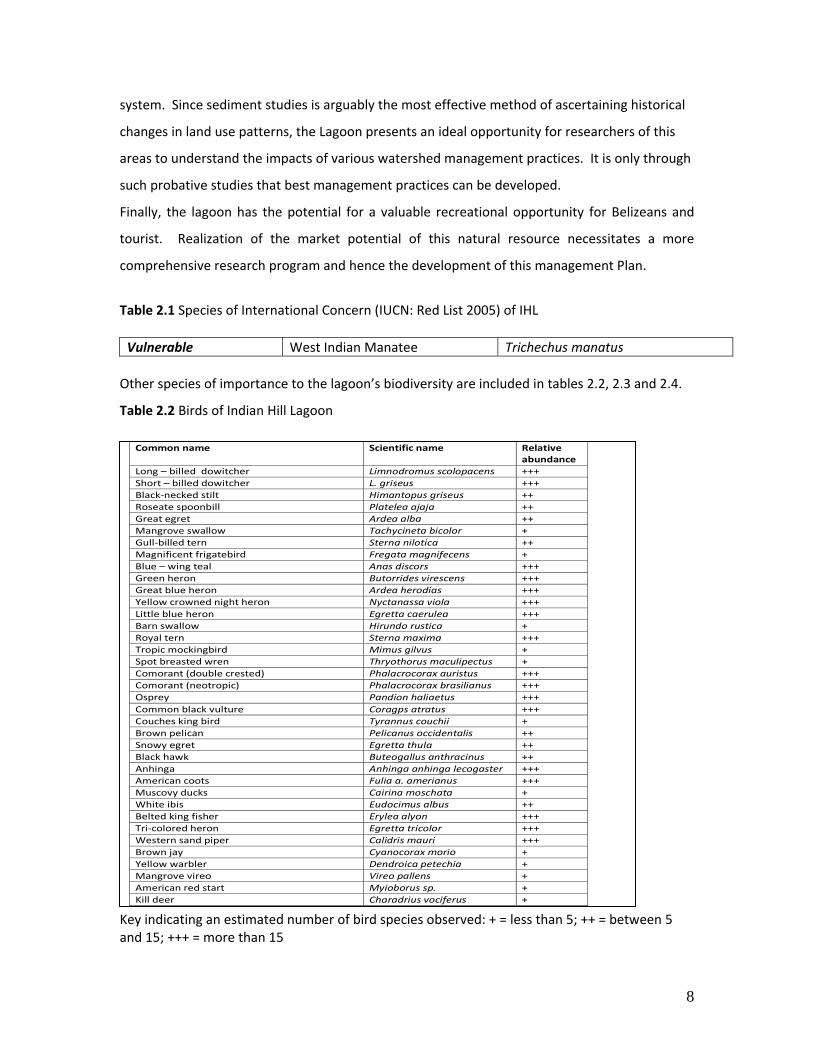
Table 2.1 Species of International Concern (IUCN: Red List 2005) of IHL
Other species of importance to the lagoon’s biodiversity are included in tables 2.2, 2.3 and 2.4.
Table 2.2 Birds of Indian Hill Lagoon
Key indicating an estimated number of bird species observed: + = less than 5; ++ = between 5 and 15; +++ = more than 15
Vulnerable West Indian Manatee Trichechus manatus
Common name Scientific name Relative abundance
Long – billed dowitcher Limnodromus scolopacens +++Short – billed dowitcher L. griseus +++Black‐necked stilt Himantopus griseus ++Roseate spoonbill Platelea ajaja ++Great egret Ardea alba ++Mangrove swallow Tachycineta bicolor +Gull‐billed tern Sterna nilotica ++Magnificent frigatebird Fregata magnifecens +Blue – wing teal Anas discors +++Green heron Butorrides virescens +++Great blue heron Ardea herodias +++Yellow crowned night heron Nyctanassa viola +++Little blue heron Egretta caerulea +++Barn swallow Hirundo rustica +Royal tern Sterna maxima +++Tropic mockingbird Mimus gilvus +Spot breasted wren Thryothorus maculipectus +Comorant (double crested) Phalacrocorax auristus +++Comorant (neotropic) Phalacrocorax brasilianus +++Osprey Pandion haliaetus +++Common black vulture Coragps atratus +++Couches king bird Tyrannus couchii +Brown pelican Pelicanus occidentalis ++Snowy egret Egretta thula ++Black hawk Buteogallus anthracinus ++Anhinga Anhinga anhinga lecogaster +++American coots Fulia a. amerianus +++ Muscovy ducks Cairina moschata +White ibis Eudocimus albus ++Belted king fisher Erylea alyon +++Tri‐colored heron Egretta tricolor +++Western sand piper Calidris mauri +++Brown jay Cyanocorax morio +Yellow warbler Dendroica petechia +Mangrove vireo Vireo pallens +American red start Myioborus sp. +Kill deer Charadrius vociferus +

9
Table 2. 3 Marine vertebrates identified within the Indian Hill Lagoon
Key indicating an estimated number of animal species observed: + = less than 5; ++ = between 5 and 15; +++ = more than 15 Table 2.4 Dominant vegetation surroundings the Indian Hill Lagoon (within 500 meters from edge of Lagoon)
Common name Scientific name Relative abundance
Yellow fin mojarra Gerres cinereus +++ Flag fin mojarra Eucinostomus melanopterus +++ Common snook Centropomus undecimalis ++ White mullet Mugil curema +++ Tarpon Megalops atlanticus + Southern sting ray Dasyatis americana ++ Spotted eagle ray Aetobatus narinari + West Indian manatee Trichechus manatus manatus ++ Herring Herengula sp. (family Clupeidae) ++ Needlefish (family: Belonidae) + Sheepshead Archosargus probatocephalus + Sea bream Archosargus rhomboidalis +++ “Calba” Centropomidae?? ++ Permit Trachinotus falcatus ++ Mangrove snapper Lutjanus griseus ++ Dog snapper Lutjanus jocu + Bar jack Caranx ruber ++ Bay snook Petenia spendida ++ Crana Cichlosoma urophthalmus ++
Common name Scientific name Sea side purslane Sesuvium portulacastrum Coco plum Chrysobalanus icaco Caribbean sedge Cyperus ligularis Palmetto Serenoa repens Sea shore salt grass Distichlis spicata West Indian creeper Wedelia trilobata Gray (Button wood) mangrove Conocarpus erectus Black mangrove Avicennia germinans Red mangrove Rhizophora mangle Caribbean pine Pinus caribe Bay cedar Suriana maritima Mangrove fern Acrosticum aureum Mimosa plant Mimosa sp. Thick pine savannah grasses Various sp? Yaha, Sandpaper tree Curatella americana Wild craboo Byrsonima sp Yemeri, San Juan Vochysia honduresis Polewood Xylopia frutescens Oak Quercus sp. Trumpet tree Cecropia peltata

10
Cultural Heritage
Hills mounds associated with Mayan settlement sites reportedly occurred (landward) in the
area, hence the name Indian Hill Lagoon. Further archeological research on this matter is
required and does not fall within the scope of this project.
2.3.4 Socio‐Economic Context According to the 2002 Poverty Assessment Report by the National Human Development
Advisory Committee, Central Statistical Office, the Toledo District has the highest poverty rate in
Belize (CSO/NHDAC, Poverty Assessment Report, 2004). The report indicated that more 60% of
the residents cannot afford their basic needs, for various reasons including, lack of opportunities
to access commercial funding for business initiatives.
The recent shift towards an increase in non‐traditional employment opportunities especially in
the area of tourism over the past decade, however, show that a significant portion of the
population of southern Belize will rely increasingly on the availability of the surrounding natural
resources for their income. And with the increased environmental awareness and promotion of
environmentally friendly income – generating ventures in this country, residents in these areas
are looking for alternative economic options to meet their daily needs. Concomitantly, there is
also a shift away from destructive fishing practices.
The major user groups of IHL include Monkey River Village, and to a significantly lesser extent,
residents of Placencia and Independence Villages and permanent workers of the former NTL
shrimp farm (Table 2.6).
Table 2.5 Population of Indian Hill Lagoon Main User Groups/Communities
Community Male Female Total NTL 8 84 92 Monkey River 92 84 176 Placencia ¿ ¿ ¿ Independence ¿ ¿ ¿ Total
Source: Central Statistical Office, Statistical Abstract 2004; IHL Project Progress Report #1, 2006

11
Table 2.6 Historical Uses of Indian Hill Lagoon Major traditional use (s) of lagoon
Mean number of years of use
Marine animal life and birds commonly seen inside and around lagoon
Fishing, hunting, cutting firewood, palmetto for lobster traps, tours (bird watching, manatee sight seeing & fly fishing), transit during stormy weather
21 years Mode: 20 yrs Range 5 to – 45 years
Egrets, bone fish, pelicans, common snook, jewfish, mutton snapper, comorant, magnificent frigate, manatee, dolphin, sheepshead, barracuda, jack, spoonbill, heron, anhinga, hawk, permit, silk snapper, mojarras, rays, grouper, mangrove snapper, tarpon, vulture
The results of a socio‐economic survey of several stakeholder user groups in Monkey River and
Independence Villages showed that a major source of income for these communities comes
from the use of natural resources in providing tourism services and fishing. Well over a third of
the population is involved in private and individual initiatives involving the utilization of natural
resources. This may mean that the communities will continue to interact with the environment
in the provision of tourism services such as guiding and sport‐fishing, and traditional uses such
as, fishing, harvesting palmetto and other plant products.
2.4 Physical Environment of IHL Management Area
2.4.1 Climate
Elevation varied from sea level at the coastal embayment to a maximum of approximately 7 m in
the Upper reaches of the Lagoon. Wind gusts were variable recording a high of 17.5 km/hr. at
site #1 and a minimum of 4.5 at site #6.
The variability of air temperature was determined in August 2007 and was largely a function of
temporal changes in direct solar radiation. The average air temperature was 34.8 0C. However,
the difference between the maximum and minimum recorded temperatures was 7 0C.

12
2.4.2 Geology
Currently there is no comprehensive data set on the geology of this area.
2.4.3 Soils
The soil is described as mature coastal deposits (Wright et al., 1958: British Honduras provisional
soil map).
2.4.4 Hydrology Table 2.7 Sampling site characterization of Indian Hill Lagoon. (Water Analyst Abelio Cho, Raymond Requena, Philip Morgan and Roy Polonio, TIDE Consultant)
Site Water Depth (m) Conductivity (mS) TDS (g/L) Water Temperature (0C)
1 0.22 13.6 12.4 33.8
2 0.10 10.1 6.3 35.9
3 0.52 19 11.4 35.6
4 0.38 8.1 5.4 32.5
5 1.07 9.9 6.5 31.7
6 0.13 11.6 7.7 31.2
Water depth varied from 0.10 m at the discharge from the former shrimp farm, to 1.07 m at site #5 within the Indian Hill Lagoon. Measurements were made on a given day.
Table 2.7 indicates that the variability of water temperature among the sites was approximately
5 0C. The highest and lowest temperatures were recorded at the sites with the least and
greatest water depth respectively. However this relative trend was not evident for the other
three sites. The apparent trend may be an artifact of the time of day each site was sampled
rather than a reflection of a relationship between water depth and temperature. Intuitively, all
factors assumed equal, water temperature should be higher at lower depths.
Total dissolve solids (TDS) of water collected from sites within Indian Hill Lagoon was between 5
and 12 g/L. Conductivity reflects the same trend described for TDS since it assesses the
concentration of salts and ions in the water sample.
13
Over the past year (August 2006‐August 2007) of regular water quality monitoring, the salinity
ranged between 31.0‐42 ppt and dissolved oxygen (DO) 4.23‐7.6 mg/l and water temperature:
30.1‐33.1 °C.
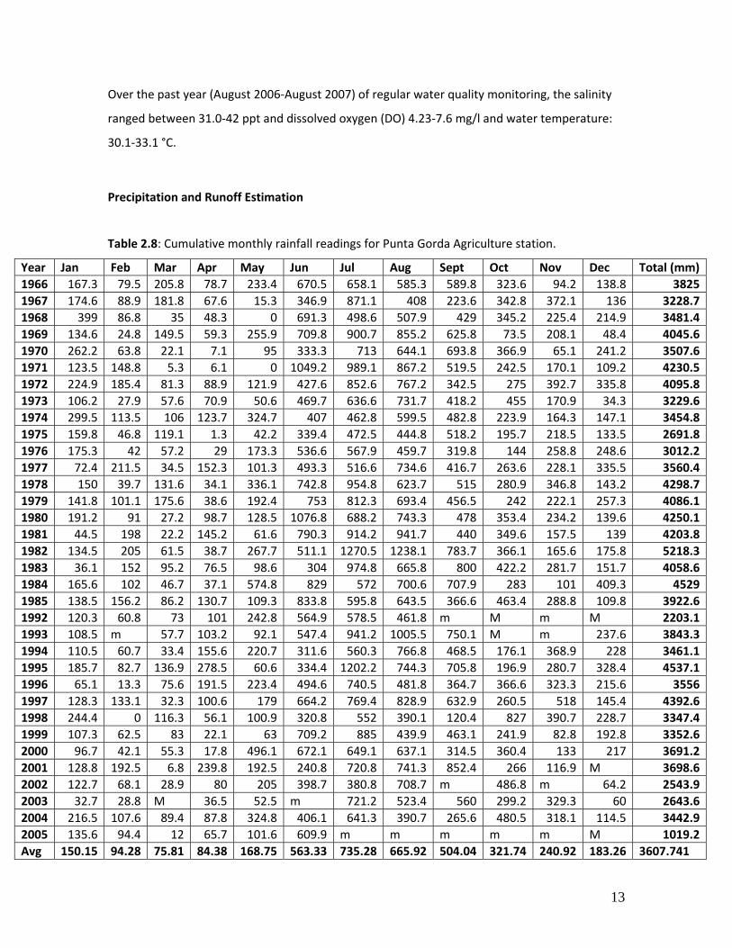
Precipitation and Runoff Estimation
Table 2.8: Cumulative monthly rainfall readings for Punta Gorda Agriculture station.
Year Jan Feb Mar Apr May Jun Jul Aug Sept Oct Nov Dec Total (mm)1966 167.3 79.5 205.8 78.7 233.4 670.5 658.1 585.3 589.8 323.6 94.2 138.8 38251967 174.6 88.9 181.8 67.6 15.3 346.9 871.1 408 223.6 342.8 372.1 136 3228.71968 399 86.8 35 48.3 0 691.3 498.6 507.9 429 345.2 225.4 214.9 3481.41969 134.6 24.8 149.5 59.3 255.9 709.8 900.7 855.2 625.8 73.5 208.1 48.4 4045.61970 262.2 63.8 22.1 7.1 95 333.3 713 644.1 693.8 366.9 65.1 241.2 3507.61971 123.5 148.8 5.3 6.1 0 1049.2 989.1 867.2 519.5 242.5 170.1 109.2 4230.51972 224.9 185.4 81.3 88.9 121.9 427.6 852.6 767.2 342.5 275 392.7 335.8 4095.81973 106.2 27.9 57.6 70.9 50.6 469.7 636.6 731.7 418.2 455 170.9 34.3 3229.61974 299.5 113.5 106 123.7 324.7 407 462.8 599.5 482.8 223.9 164.3 147.1 3454.81975 159.8 46.8 119.1 1.3 42.2 339.4 472.5 444.8 518.2 195.7 218.5 133.5 2691.81976 175.3 42 57.2 29 173.3 536.6 567.9 459.7 319.8 144 258.8 248.6 3012.21977 72.4 211.5 34.5 152.3 101.3 493.3 516.6 734.6 416.7 263.6 228.1 335.5 3560.41978 150 39.7 131.6 34.1 336.1 742.8 954.8 623.7 515 280.9 346.8 143.2 4298.71979 141.8 101.1 175.6 38.6 192.4 753 812.3 693.4 456.5 242 222.1 257.3 4086.11980 191.2 91 27.2 98.7 128.5 1076.8 688.2 743.3 478 353.4 234.2 139.6 4250.11981 44.5 198 22.2 145.2 61.6 790.3 914.2 941.7 440 349.6 157.5 139 4203.81982 134.5 205 61.5 38.7 267.7 511.1 1270.5 1238.1 783.7 366.1 165.6 175.8 5218.31983 36.1 152 95.2 76.5 98.6 304 974.8 665.8 800 422.2 281.7 151.7 4058.61984 165.6 102 46.7 37.1 574.8 829 572 700.6 707.9 283 101 409.3 45291985 138.5 156.2 86.2 130.7 109.3 833.8 595.8 643.5 366.6 463.4 288.8 109.8 3922.61992 120.3 60.8 73 101 242.8 564.9 578.5 461.8 m M m M 2203.11993 108.5 m 57.7 103.2 92.1 547.4 941.2 1005.5 750.1 M m 237.6 3843.31994 110.5 60.7 33.4 155.6 220.7 311.6 560.3 766.8 468.5 176.1 368.9 228 3461.11995 185.7 82.7 136.9 278.5 60.6 334.4 1202.2 744.3 705.8 196.9 280.7 328.4 4537.11996 65.1 13.3 75.6 191.5 223.4 494.6 740.5 481.8 364.7 366.6 323.3 215.6 35561997 128.3 133.1 32.3 100.6 179 664.2 769.4 828.9 632.9 260.5 518 145.4 4392.61998 244.4 0 116.3 56.1 100.9 320.8 552 390.1 120.4 827 390.7 228.7 3347.41999 107.3 62.5 83 22.1 63 709.2 885 439.9 463.1 241.9 82.8 192.8 3352.62000 96.7 42.1 55.3 17.8 496.1 672.1 649.1 637.1 314.5 360.4 133 217 3691.22001 128.8 192.5 6.8 239.8 192.5 240.8 720.8 741.3 852.4 266 116.9 M 3698.62002 122.7 68.1 28.9 80 205 398.7 380.8 708.7 m 486.8 m 64.2 2543.92003 32.7 28.8 M 36.5 52.5 m 721.2 523.4 560 299.2 329.3 60 2643.62004 216.5 107.6 89.4 87.8 324.8 406.1 641.3 390.7 265.6 480.5 318.1 114.5 3442.92005 135.6 94.4 12 65.7 101.6 609.9 m m m m m M 1019.2Avg 150.15 94.28 75.81 84.38 168.75 563.33 735.28 665.92 504.04 321.74 240.92 183.26 3607.741

14
Table 2.9: Estimation of runoff using the energy budget method based on a 39 year average (1966‐2005).
Month Temp 0C
Energy (calories)
Volume (cm3)
Evap. (m3)
Rain (cm)
Rain (m3)
Discharge (m3)
January 23.8 2.59E+14 4.46E+11 445699.9 15.12.42E+
5 ‐2.04E+5
February 25.5 2.39E+14 4.12E+11 411870.4 9.41.50E+
5 ‐2.61E+5
March 26.4 2.68E+14 4.62E+11 461523.8 7.61.22E+
5 ‐3.40E+5
April 27.1 2.62E+14 4.51E+11 450827.6 8.41.34E+
5 3.16E+5
May 28.3 2.75E+14 4.73E+11 473351.2 16.92.70E+
5 2.03E+5
June 28.8 2.68E+14 4.61E+11 461130.1 56.39.01E+
5 4.40E+5July 28.3 2.75E+14 4.73E+11 473351.2 73.5 1.18E6 7.03E+5August 28.6 2.76E+14 4.75E+11 475239.2 66.6 1.07E6 5.90E+5
September 28.4 2.66E+14 4.59E+11 458690.2 50.48.06E+
5 3.48E+5
October 27.5 2.72E+14 4.68E+11 468343.9 32.25.15E+
5 4.69E+4
November 25.8 2.57E+14 4.43E+11 443066.5 24.13.86E+
5 ‐5.75E+4
December 24.4 2.61E+14 4.49E+11 449314.9 18.32.93E+
5 ‐1.57E+5
Discharge measurements
Table 5 shows that the total rate of discharge to Lagoon was 0.053m3/sec for the specific time of
sampling during August 2007 when all operations from the farm were halted.
Table 2.10: Discharge rate from the shrimp pond outflow to Indian Hill Lagoon.
Section (m) Depth (m) Width
(m)
Velocity (m/sec)
Cross Sectional Area (m2)
Discharge (m3/sec)
1 0.0508 1.2192 0.150891 0.06195536 0.0093485
2 0.1016 1.2192 0.150891 0.012387072 0.01869097
3 .013335 1.2192 0.150891 0.1625803 0.024531907
The total rate of discharge to the coastal embayment from the drainage ditch to the Indian Hill Lagoon at the time of sampling was 0.053m3/sec.

15
2.5 Biodiversity of Management Area
2.5.1 Ecosystems The lagoon proved rich in biodiversity. Records of birds, marine life and vegetation found inside
and or within the immediate vicinity of the lagoon are presented in Tables 2, 3 and 4,
respectively. Data on other terrestrial animals remains lacking. So far, at least 34 different
species of birds and 16 species of aquatic animals have been identified in the lagoon.
Birds associated with the lagoon include roseatte spoon bills (Platelea ajaja ) (Figure 2), herons,
comorants (Phalacrocorax auristus), egrets, anhingas (Anhinga anhinga lecogaster) and
dowitchers (Limnodromus sp.). The migratory American coots (Fulia a. amerianus) and muscovy
ducks (Cairina moschata) have also been seen in the lagoon during the month of November,
2006.
Aquatic species frequently sighted include the West Indian manatees (Trichechus manatus
manatus), Southern sting rays (Dasyatis americana), mojarras (Gerres sp), common snook
(Centropomus undecimalis). Several of the highly valuable, elusive permits (Trachinotus falcatus)
also occur within this system. The local community volunteers and TIDE rangers (also from
Monkey River), fishers and tour guides of Monkey River Village marveled at the many manatee
sightings in September, 2006, something they had not seen in the area for many years!
Approximately 20 of the predominant plant species in the surrounding area have been
identified. The tall, lush mangrove forest was characteristic of this lagoon (Figure 3). Palmetto
trees were commonly seen throughout the area.
2.6 Cultural and Socio‐Economic Values of Management Area 2.6.1 Community and Stakeholder Use According to a survey conducted in August 2006, historically, the IHL has been used for fishing,
tourism and hunting. Majority of the users of IHL were residents of Monkey River Village; a few
were from Independence Village in Southern Belize. More recently many of the respondents
have been using the lagoon for fishing or tour guiding purposes, including bird‐watching, sport

16
fishing and manatee watching (Tables 2.6; 2.11). They asserted however that NTL shrimp farm
had been impacting this lagoon for the past 8 years or so.
Table 2.11 Lagoon resources use profiles & user groups
Products/Activities Users Purposes Palmetto Sticks Fisher folks construction of traps for
fish and lobster Fisher folks commercial Fishing Households subsistence Sport‐fishers commercial Sport‐fishing Tour guides commercial
Bird watching Tour guides commercial Manatee watching Tour guides commercial Products and resources used by the respondents include fish and palmetto sticks.
In a separate survey which was conducted in October, 2007, (~10 months later), the majority of
the respondents (>50%) estimated that they could earn BZD$100.00 or more per week from the
lagoon’s resources (See Summary report of Monkey River Survey (Appendix 1)
2.6.2 Recreation and Tourism Use The Indian Hill Lagoon is considered excellent habitat for tarpons, bone fish and the elusive
permit, thus accommodating fly‐fishing (catch and release), making it a significant tourism
resource for the area. These fly‐fishing guides are mainly from Monkey River Village and at times
from Placencia and Independence Villages. Currently, Monkey River fisher folks and tour guides
are looking forward to using this lagoon to sustain their alternative livelihoods.
2.6.3 Other Economic Use The harvesting of palmetto seeds (Acoelorraphe wrightii) is becoming a potential industry in the
area, with the prospect for financial benefits to a number of local communities. The harvesting
methods are not always sustainable, with some trees being chopped down in entirety to allow
harvesting of the seeds.

17
2.6.4 Education Use
To date, use of the Lagoon for educational purposes has been limited to the current biodiversity
and water quality studies. Student groups and University of Belize Professors mainly from Punta
Gorda Town, and Monkey River Village have assist Consultant Polonio and thus occasionally
made use of the lagoon for Educational Purposes. This Lagoon has been highly recommended by
Dr. Ed Boles, Aquatic pathologist, for further studies involving assessment of macroinvertebrates
and diatoms as potential biomarkers of ecosystem health. Dr. Philip Morgan, Hydrologist,
recognizes that sediment studies is arguably the most effective method of ascertaining historical
changes in land use patterns, contends that the lagoon provides ideal opportunity for
researchers of this area to understand the impacts of various watershed management practices.
TIDE will assist the IHL Management Committee to develop a more structured program that will
include students from the other buffer communities and a wider age range of participants such
as the adult members of the communities. The program will be geared toward addressing key
issues for IHL management such as knowledge of the importance of the Lagoon, location,
threats to the it and ways that members from buffering can become more actively involved in its
protection.
Section III CONSERVATION PLANNING 3.1 Analysis of Conservation Targets and Threats Management activities will focus on species considered as conservation targets. These targets
are of a particular threat, or are of local, national or international concern; their presence and
abundance will indicate the health of the ecosystems. The IHL management plan addresses local
and/or immediate threats to the ecosystems and/or species of conservation interest on the
local/national level as a first priority(s), and on an international level as a second priority.
18
3.1.1 Identification of Conservation Targets and Threats The identification of conservation targets and threats is based on findings from previous work
conducted by the Consultant in conjunction with TIDE personnel and Monkey River Community
volunteers.
The following conservation targets were selected: Ecosystem Target Mangrove and Sea grass Habitats Species Groupings Marine Species (sport fishing: permit, tarpons, bone fish) Species Targets West Indian Manatee The justification for the selection of the conservation target, along with its principle threat(s) is provided in Table 3.1.

19
Table 3.1 Summary of Conservation Targets, Justification for Conservation, Target Selection and Threats Conservation Target
Species, Communities or Ecological Systems represented by Target
Threat
Mangrove Habitats Marine Vertebrates, including permit (Trachinotus falcatus), West Indian manatee (Trichechus manatus), the southern sting ray (Dasyatis americana) spotted eagle ray (Aetobatus narinari) and several species of water birds, including White Ibis (Eudocimus albus), Roasette spoon bill (Platelea ajaja) Muscovy ducks (Cairina moschata) and herons: little blue heron (Egretta caerulea), Yellow crowned night heron (Nyctanassa viola), Great blue heron (Ardea herodias), (Green heron) Butorrides virescens), Tri‐colored heron (Egretta tricolor). Oysters also depend on the mangrove habitats.
Illegal extraction (Potentially) Excess nutrient load from effluent discharged from NTL Farm, causing overgrowth of mangroves and blocking channels, setting of gill net, degradation of water quality
Coastal Ecosystem/Seagrass Habitat
West Indian manatee (Trichechus manatus), the southern sting ray (Dasyatis americana) spotted eagle ray (Aetobatus narinari) and several fish species of depend on sea grass directly or indirectly for food. The sea grass also play a vital role in absorbing excess nutrients in the water and help in regulating water quality
Excess nutrient load from effluent discharged from NTL Farm, causing overgrowth of epiphytes on seagrass blades, reducing availability of food and contributing to further deterioration of water quality
The Palmetto Palm The Palmetto Palm (Acoelorraphe wrightii) seeds valued for export (medicinal uses)
Illegal extraction (Potentially)
Marine Species (sport fishing)
Permit, tarpon and bone fish as part of the food chain create a balance in the population of certain species within the lagoon
Degradation of water quality and gill net
West Indian Manatee (Trichechus manatus)
Listed as a vulnerable species (IUCN Redlist) Considered an ideal umbrella species for the health of seagrass ecosystems, as well as being an early indicator of disturbance through land development and increased boat activities, being the first and most obvious species to stop utilizing the area.
Degradation of water quality and deteriorating health of sea grass, use of gill net

20
3.1.2 Assessment of Conservation Target Viability
Conservation planning relies heavily on assessing the status of conservation targets over time,
thus enabling planners to see whether management actions are successful in bringing about the
desired changes. Current conservation planning tools therefore presents the status of the
conservation targets in a standardized manner, allowing for comparison over time. The four
recommended conservation targets have been rated according to their viability within each of
the three TNC Viability Criteria: Size, Condition and Landscape Context (Table 3.2), with
justification for the ratings chosen – Very Good, Good, Fair or Poor (Table 3.3).
Table 3.2 The Nature Conservancy Viability Criteria
Table 3.3 The Nature Conservancy Viability Rating
TNC Viability Criteria
Size A measure of the target’s area or abundance, based on the minimum requirement needed to ensure survival after natural disturbance
Condition An integrated measure of community composition, structure and biotic interactions (eg. structure, population components etc.)
Landscape Context
An integrated measure of two factors – key elemental processes that sustain the species or ecosystem, and connectivity
TNC Viability Ratings
Very Good
Score 4 Functioning at an ecologically desirable status, and requires little human intervention
Good
Score 3.5 Functioning within its range of acceptable variation; may require some human intervention
Fair
Score 2.5 Lies outside its range of acceptable variation and requires human intervention. If unchecked, the target will be seriously degraded
Poor
Score 1.0 If allowed to remain in the present status, restoration or preventing local extinction will be impossible

21
Viability Rankings for Conservation Targets
Following an assessment of the conservation targets chosen (Table 3.4), an overall viability ranking for each target was established, using the TNC 5‐S System. Under this system, each viability rating was given a score, and the average then calculated for each conservation target to give an overall viability rating, with the averaged results being ranked.
Viability Ratings
Conservation Target: Coastal Lagoon Ecosystem/seagrass beds
TNC Viability Criteria
TNC Viability Rating Justification
Size Good A mangrove / marine ecosystem complex incorporating Indian Hill Lagoon, with sufficient area and resilience to be able to recover after natural disturbance.
Condition Fair The current condition is fair as the shrimp farm formerly polluting the lagoon is no longer operating and, with the absence of major nutrient input the lagoon is reestablishing itself. Serious concerns exist regarding any developmental impacts that may occur due to future shrimp farming activities that could potentially be continued if the this area is purchased for shimp farming.
Landscape Context
Fair The lagoon ecosystem receives freshwater primarily from rainfall and salt water from the sea to the East‐North East of it. It also receive nutrients and salts from effluent discharges directly into it by the NTL shrimp farm whenever the farm was in operation. Lagoon discharges into the Caribbean sea.
Conservation Target: West Indian Manatee
TNC Viability Criteria
TNC Viability Rating Justification
Size Good Recovering from previous water quality perturbance within the area, now that NTL is closed down and no longer in operation
Condition Fair Enforcement is now preventing hunting, age structure presumed to be returning to a natural equilibrium. Mating groups and mother‐and‐calf pairs seen within the lagoon
Score Viability Rating
>=3.75 Very Good
3.0 – 3.74 Good
1.75 – 2.99 Fair
<1.75 Poor

22
system
Landscape Context
Good The Belize population of manatees is in a stage of steady recovery from previous hunting pressure, but there are increasing impacts from development activities (removal of seagrass during dredging activities, sedimentation), increased boat traffic, accidental deaths in nets set over creek mouths, and still some hunting, so human intervention is required to ensure its survival.
Conservation Target: Mangrove Habitat
TNC Viability Criteria
TNC Viability Rating Justification
Size Very Good Lush mangrove forest Teeming with the three dominant species (Rhizophora mangle, Aviccenia germinans and Laguncularia racemosa)
Condition Good The closure of NTL brings an end to the discharge of the nutrient loaded effluent, which was contributing significantly to the accelerated growth rate of mangroves over the last 8‐10 years.
Landscape Context
Very Good Many birds, fishes and invertebrates continue to benefit from the IHL mangrove forest, which also has been absorbing much of the excessive nutrients resulted from NTL ‘s discharge. Nursery, habitat, biofiltration and nutrient recycling. Helping to minimize the amount of nutrient flowing out into the Caribbean Sea
Conservation Target: Palmetto Palm
TNC Viability Criteria
TNC Viability Rating Justification
Size Fair These plants occur in the relatively low abundance and their use will increase
Condition Fair The potential for an increase in the extraction of this resource for the making of fish traps and traditional medicinal purposes suggest an increased pressure on this resource
Landscape Context
Good Palmetto forms a part of the pine savannah eco‐region, which is considered endangered / critically endangered.

23
The conservation targets for IHL were then rated based on their overall viability (Table 3.5). The
coastal lagoon ecosystem and the palmetto palms themselves have fair overall viability in their
current status. The West Indian manatee and mangrove forest are deemed to have good
viability (requiring limited human intervention) and require greater human intervention,
especially if the new buyers of NTL Shrimp farm plans to undertake similar aquaculture venture
in same general area. (Table 3.5).
Table 3.5 Ratings of Conservation Targets
Conservation Target Size Condition Landscape Context
Overall Viability Rating
CoastalLagoon Ecosystem/seagrass
Good (3.5) Fair (2.0) Fair (2.0) Fair (2.5)
West Indian Manatee Good (3.5) Fair (2.0) Good (3.5) Good (3.0)Mangrove Habitat Very Good (3.5) Good (3.5) Very Good
(3.5)Good (3.5)
Palmetto Palm Fair (1.75) Fair (2.0) Good (3.5) Fair (2.4)Overall Viability Rating Very Good: Viability criteria at or above desired future statusGood: Viability at or above minimum threshold for biological integrity Fair: Viability criteria at or above a minimum restorable levelPoor: Viability criteria below minimum restorable status (probably unrecoverable)
3.1.3 Threats to biodiversity
Having assessed the biodiversity for viability, the threats to biodiversity were identified for the
lagoon area. A threat analysis for each conservation target was conducted based on the World
Conservation Society Rankings (WCS). This threat analysis involved gathering information on the
following:
1. Threat status (Historical, Present/Active, Potential) 2. Conservation Target affected by the Threat 3. Source of Threat (Direct and Indirect) 4. Area (How much of the conservation target it affects)

24
5. Severity
6. Urgency (Likelihood of threat occurring over the next five years)
7. Recovery Time (Length of time for target to recover following major disturbance)
Recovery Ranking (adapted from WCS)
Criteria Score
3 100+ years or never
2 11‐100 years
1 1‐10 years Recovery
0 Immediate
Proportion of Area Affected (adapted from WCS)
Criteria Score
4 Will affect throughout >50% of the area
3 Widespread impact, affecting 26 – 50% of the area
2 Localized impact, affecting 11 – 25% of the area
Area
1 Very localized impact, affecting 1 – 10% of the area
Severity Ranking (adapted from WCS)
Criteria Score
3 Local eradication of target possible
2 Substantial effect but local eradication unlikely
1 Measurable effect on density or distribution
Severity
0 None or positive
Urgency Ranking (adapted from WCS)
Criteria Score
3 The threat is occurring now and requires action
2 The threat could or will happen between 1 – 3 years
1 The threat could happen between 3 – 10 years Urgency
0 Won’t happen in > 10 years

25
8. Probability of Threat Occurring (During timeframe of management plan)
Probability Ranking (adapted from WCS)
Criteria Score
1.00 0.76‐1.0
0.75 0.51‐0.75
0.50 0.26‐0.50 Probability
0.25 ≤0.25
The total score for each threat was then calculated using the equation:
A total of seven threats were identified:
Direct:
Shrimp farming by the Former Nova Toledo Limited in adjacent areas Illegal Fishing (Use of gill nets) Illegal extraction of Acoelorraphe sticks and potential for extraction of the seeds
Indirect
Lack of Compliance by NTL Lack of meaningful monitoring of NTL’s Environmental Compliance Plan (ECP) by relevant government agencies Lack of a management plan/regulations governing the proper use lagoon
resources Lack of income opportunities for user groups
Of each of the direct threats, a threat assessment was conducted (Table 3.6). Table 3.6 Threat Assessment for Conservation Targets Threat 1: Shrimp farming by the former Nova Toledo Limited in adjacent areas
Continuous discharge of nutrient‐ and sediment‐loaded effluent into IHL by Nova Toledo Limited Shrimp Farm
Status Historical (Present/Active) Potential?
(Urgency + Recovery) x Severity x Area x Probability

26
Target Coastal lagoon ecosystem (water quality)
Source
Direct: NTL shrimp farm on‐going discharge of nutrient –rich effluent and sediment
Indirect: Lack of meaningful monitoring of NTL’s Environmental Compliance Plan (ECP) by relevant government agencies.
Lack of a management plan/regulations governing the proper use lagoon resources
Area 4 The entire lagoon system (~100%) has been impacted by effluent discharge over the past 8 years
Severity 3
The lagoon ecosystem has been eutrophic which has been contributed to the lose and/ or the decrease in population in several species including bone fish, tarpons, oysters , manatees, permit and mangrove snappers, and reduction in sea grasses.
Urgency 3 Currently under threat. Even though the system is under going self restoration if this is not allowed to continue its course, the ecosystem will degrade still further
Recovery Time 1 Recovery of water quality and biodiversity will occur within 10 years
with proper management measures in place.
Probability of Threat Occurring
1 The threat remains in effect as long as shrimp farming continues in that area
Threat 2: Illegal fishing
Frequent use of gill net by fisher folks from Independence village
Status Active
Target Tarpoon, permit, mangrove snappers, common snook, mojarass, whit mullet
Source
Direct: Hunters from all local communities, reported to be hunting within the protected area, particularly in the Deep River extension
Indirect: Lack of a management plan/regulations governing the proper use lagoon resources
Area 3 Concentrated primarily in the areas having depth greater than 3ft .
Severity 2 This practice could have significant effect but unlikely to cause eradication and stifle sport fishing efforts
Urgency 3 Currently occurring.
Recovery Time 1 Most of these species are still present, so populations should
recover over the course of 10 years

27
The resultant total threat scores were ranked (Table 3.7) Table 3.7 Total Threat Scores for the Conservation Targets
Probability of Threat Occurring
1 The threat is occurring at present, and will continue to occur until regulation are implemented to halt it
Threat 3: Harvesting of Acoelorraphe from the Indian Hill Lagoon area
Harvesting of Acoelorraphe sticks for lobster/fish traps and seeds for export
Status Sticks (Active?); Seeds (Potential)
Target Accoelorraphe, a species found in the mangrove forest
Source
Direct: Harvesting of sticks by fisher folks from Monkey River Village and seeds by surrounding local communities
Indirect: High poverty level in adjacent communities, few employment opportunities
Area 1 Harvesting of sticks is infrequent seasonal and the potential for the harvesting of seeds in this area uncertain. Occurrence is restricted only a few area around the lagoon.
Severity 3 Local eradication of target possible if harvesting goes unregulated
Urgency 2
The threat could happen between 3 – 10 years; presently the threat is not much of a concern because population of user groups is relatively low and the harvesting of sticks is controlled by seasonal nature of fish trap making; the pressures for seeds may increase as awareness about their medicinal values increase
Recovery Time 1
Once harvesting of sticks and seeds stops, this species will recover relatively quickly, providing that the parent stock are also being not cut down for sticks.
Probability of Threat Occurring
0.75 Increasing pressure on surrounding seed
Criteria Ratings
Threats
Area Severity
Urgency
Recovery Probability
Total threat Score
Ranked
Threat*
Shrimp farming by the former Nova Toledo Limited in adjacent areas
4 3 3 1 1
48 3
Illegal fishing 3 2 3 1 1 24 2 Harvesting of (Acoelorraphe wrightii) from the Indian Hill Lagoon area
1 3 2 1 0.75 6.75 1
* Lowest threat score rank = 1

28
Threats can therefore be ranked as follows: Shrimp farming Harvesting of (Acoelorraphe wrightii) Illegal fishing 3.2 Management Constraints and Limitations Based on the experience of the staff, the assessments conducted for this Plan and stakeholder
consultations, several management constraints and limitations have been identified for the
IHLMA. These include:
Uncertainty whether the lagoon and immediate surrounding will obtain protective status The absence of rules and regulations governing the management of the lagoon’s resources and
the uncertainty whether this area will be granted protected areas’ status are a great cause for
concern.
Diverse uses/purposes intended for the lagoon between the shrimp farm and local communities presents greater challenge. This diversity means that the IHLMA staff and the Environmental Education/Community
Outreach staff will have to be able to ethnically and culturally sensitive to the people,
understand various cultural and traditional practices and be able to communicate in Creole and
Spanish mainly. A small percentage of the residents speak only Kekchi Maya and Mopan Maya.
Limited Human and Financial Resources Currently, there is no officially approved management plan, registered managing
committee/association, nor finance, to fund management of the lagoon and its resources. It is
also uncertain whether approval will be granted by the Government of Belize to put this area
under protection. Presently the major threat to the lagoon is posed by shrimp farming and while
the lagoon is enjoying the reduced environmental stress that comes with the closure of NTL
shrimp farm around January, 2007, a new company, Musa & Associates has purchased the same
estate, most likely for shrimp farming purposes (DOE, 2007). Plans for the farm sites, including
the development of an environmental impact assessment (EIA), environmental compliance plan
(ECP), and concerns about the integrity of the lagoon remain obscure.
29
Accessibility The lagoon has three principle routes of access. The first of these is the Southern Highway
through Nova Toledo Limited farm site; the second and third by sea via Monkey River and
Placencia, respectively.
3.3 Opportunities for the Management of the Protected Area
Willingness of Stakeholders to Engage Themselves in the Protection of the IHLMA The majority of the respondents (80%) interviewed in the socio‐economic survey stated that the
Lagoon is extremely or fairly important to their livelihood (Appendix 1). The respondents
indicated that they are likely to participate in pertinent initiatives and are willing and prepared
to commit and engage themselves with help from TIDE in the management and governance of
IHL. Respondents felt that their involvement can best be done through community education
and active participation in community consultations, in collaboration with TIDE.
The Community Ranger Program for TIDE’s Paynes Creek National Park (PNCP) can be extended
to IHL in order to increase the communities’ capacity to manage and protect the Lagoon’s
natural resources. The Program equips those members of the community who frequent the
lagoon such as fishers and tour guides with hand held radios so that they can report any illegal
activity or emergency situations to the IHLMA staff. Additional support from TIDE’s Biologist
with water quality monitoring and monitoring of target species serving as biological indicators
would really be an asset.
Promotion of the Lagoon In order to increase awareness of the Lagoon, the IHL Managing Committee must also develop a
mass media marketing and promotional campaign for the Lagoon that could include web
information, radio and television advertisements, signs, posters, exercise books for students,
brochures, flyers and a film documentary (Spanish and English). The film documentary can
address key resource uses as bird watching and sport fishing. Effort should also be made attract
more scientists to conduct research in the area.

30
A more structured Environmental Education Program must also be established by having an
annual calendar of activities that will cater to the needs of schools and other educational
organizations, the general public, shrimp farmers of the area. Educational/awareness activities,
including field visits to the IHLMA can be carried out during special occasions such as Children’s
Week, Education Week and Summer Holidays.
Increase Economic Opportunities for Local Communities During the INITIAL stakeholder consultations held as part as the management plan development
process, the need to now develop and establish tourist attractions for the Lagoon such as visitor
centre, bird watching, fly fishing, manatee watching activities and tours. Stakeholders felt that
TIDE should advocate for financial and technical assistance that will provide communities with
opportunities to access resources for business initiatives such as eco‐tourism development
projects.
Collaboration with other organizations near the lagoon or with vested interest in the Gulf of
Honduras regions
The IHLMA staff will collaborate closely with the Port Honduras Marine Reserve and PCNP staff
to conduct joint patrols within both the lagoon management area and the Marine Reserve, and
will support each other in day to day activities such as research, hosting educational groups,
community meetings etc.
A schedule of joint patrols with the Fisheries Department and perhaps Friends of Nature should
also be carried out on occasions.
The Managing Committee should also collaborate with the shrimp farm industry, Department of
the Environment (DOE), BAHA and particularly with the new developer who owns lands within
the lagoon area to monitor activities and environmental quality.
31
Section IV MANAGEMENT PLANNING 4.1 Management and Organizational Background Discussions will initially concentrate on the management and organizational background
of Payne’s Creek National Park (PCNP) because the PCNP staff will play a pivotal role in the day‐
to‐day activities of the Indian Hill Lagoon (PCNP Management Plan, 2006). Presently there is no
Managing Committee or managing structure for the IHLMA.
The Payne’s Creek National Park is staffed with a manager, a head ranger and two full
time rangers. Temporary rangers are employed particularly during the fire season. The staff
conducts patrols to monitor activities to reduce threats to the integrity of the Park such as
hunting, fishing and wild forest fires. Rangers also play an active role in research activities
conducted in the Park and in maintaining the support of communities in the management of the
Park through community outreach and environmental education activities.
The PCNP staff is also supported by the TIDE Management Staff which includes the
Executive Director, the Science and Stewardship Director, the Director of Operations and the
Development Director. The Science and Stewardship Director is responsible for overseeing the
management of the Park.
To assist the staff in carrying out these duties, PCNP is equipped with a ranger station, a
fiberglass skiff, an all terrain vehicle, a lawn tractor and two bicycles for patrols. The PCNP
ranger station is equipped with a base radio and the rangers have hand held radios to
communicate with the neighboring Port Honduras Marine Reserve ranger station and the TIDE
headquarters.
The PCNP staff has received training in protected area management, fire management
and law enforcement. The manager has obtained Special Constable status through training with
the Belize Police Department.
4.2 Management Goal for Indian Hill Lagoon Management Area This lagoon has been identified as an area highly worthy of protection in order to preserve its
biodiversity and to promote the sustainable use of its resources through alternative livelihoods.

32
This will be achieved through a set of programs and activities ensuring that the health of the
natural resources of the lagoon is sustained.
4.3 Management Strategies The proposed approach to the conservation of IHL includes:
Protected Areas Planning and Management To protect conservation targets by promoting and leading the planning and management processes
Promotion of Sustainable Development To foster integrated conservation and development initiatives which generate opportunities for the residents and lead to the sustainable development of the area
Research and Monitoring To maintain the biodiversity and integrity of the ecosystems through continuous research, monitoring and appropriate interventions
Environmental Education and Outreach To expand and enhance awareness and knowledge base about the area’s natural resources as this will promote its protection and sustainable use
The management strategy for the lagoon takes into consideration the four components listed
above, recognizing that to ensure the long term ecological integrity of the Lagoon, a balance of
all four components must be achieved.
4.4 Management Programs and Objectives The Management Programs and Objectives for the lagoon are based on an analysis of the
threats and opportunities identified in Section III of this document.
Four programs have been identified for the lagoon:
Site Protection Program/Water Quality Management Program
Alternative Livelihood Development Program
Administrative Capacity Enhancement Program
Research and Monitoring Program

33
4.4.1 Site Protection Program
Background: The site protection program focuses on the correction of degraded water quality in the
lagoon. For the site protection program to be effective, major adjustments must be made to
promote responsible shrimp farm practices in the area, if shrimp farming is allowed at all. There
has been a lack of appreciation among previous shrimp farm owners/developers operating near
IHL for the need to adhere strictly to environmentally sound practices. A technical report is
being submitted by TIDE to the relevant governmental agencies of Belize that are responsible
for regulating shrimp farming in this country, addressing this very concern. Much lobbying must
be undertaken urgently to ensure that the water quality in the lagoon is restored.
Management Objective: To prevent negative impacts on the lagoon from effluent discharged from nearby shrimp farm
Management Actions: If shrimp farming is allowed to continue on the former NTL shrimp farming site i) Perform regular water quality monitoring at key stations on farm sites and within the lagoon
ii) Perform regular detailed site inspection of production ponds and containment pond(s) of shrimp farm
iii) Participate in the evaluation/review of Environmental Impact Assessment (EIA) and Environmental Compliance Plan (ECP) of any new shrimp farm proposed for the area
iv) Monitor the ECP and make recommendations v) Develop and implement Lagoon Awareness Program to educate key shrimp farm personnel about the importance of the lagoon, boundaries, regulations, unacceptable nutrient levels in effluent discharged into the lagoon vi) Implement Community Ranger Program to allow Monkey River fishers to become actively involved in Lagoon Protection

34
4.4.3 Alternative Livelihood Development Program Background: The alternative livelihood development program is designed to improve economic
opportunities for user groups (residents of Monkey River, Independence, Placencia and shrimp
farm workers), by engaging in activities that are in line with the sustainable development of the
lagoon. The focus will be on the development of basic infrastructure for the IHLMA to
accommodate visitors, marketing of IHLMA and training of IHLMA staff and tour guides of the
area. A portion of the funds generated will be used to offset the management costs for the
lagoon.
Management Objective: To expand recreational/economic opportunities that is
consistent with lagoon regulations Management Actions: i) Develop tourism attraction sites in IHLMA including
basic infrastructure with support and assistance from user groups communities and settlements ii) Develop marketing and promotional package for Lagoon
(lagoon videos in English, Spanish, Mopan and Kekchi Maya), signs, posters, ads, exercise book program; publicity campaign (hiking, kayaking competition)
iii) Promote training to improve visitor use experience such as site specific guide certification (bird watching, fly fishing, etc)
4.4.4 Administrative Capacity Enhancement Program Background: The development of the capacity of the staff to manage the IHLMA must take priority;
successful implementation of the plan will be dependent upon the accomplishment of this
objective. The focus of this program will be on training, increasing staffing for the lagoon,
infrastructure development, improving transportation and communication.
Management Objective: To improve the administrative capacity for effective management of IHLMA Management Actions: i) Develop training program for the staff that can be
implemented at different stages/levels. Training to

35
cover all aspects of protected area management including visitor management, financial and administrative management.
ii) Improve communications system between IHLMA Head Office,TIDE and other partners
iii) Acquire boats that can also serve to transport equipment. iv) Develop administrative building in Monkey River Village
to improve on site management of visitors, staff and equipment
v) Establish financial (independence) sustainability of Lagoon
4.4.5 Research and Monitoring Program Background: During 2006‐2007, several baseline assessments were conducted for the lagoon
including, biological, hydrological and socio‐economic studies. These assessments also identified
potential research and monitoring priorities for the lagoon. The research and monitoring
program for the lagoon will focus on providing information that will assist the lagoon staff in
addressing key management issues for the area.
Management Objective: To create a structured research program that supports the
management objectives of the lagoon and provide income generation through provision of facilities.
Management Actions: i) Redefine priorities for the lagoon based on the baseline
assessments conducted during the development of the plan.
ii) Establish linkage with local and foreign educational institutions with the aim of building long term relationships
iii) Assists Belizean students and scientists in identifying training opportunities.
The lagoon has a relatively small surface area of 1.6 km2 (395.4 acres) (Morgan, 2007) and is
shallow, so it is not necessary for establish separate zones (recreational use and conservation
zone); the entire lagoon and its immediate surroundings will serve for recreational and
conservation purposes without establishment of spatial zonation.
The Recreational Use
36
Objective: To promote the recreational and economical value of the area through its
enhancement of tourism activities; to increase economic benefits to the
communities and the lagoon and to allow for research and education.
Regulations:
• Non‐extractive recreational activities allowed such as site‐seeing and kayaking
• A policy of catch and release fishing for all tarpon, bonefish and permit will be applied within the Park.
• All visitors must be escorted by a site specific tour guide. • All visitors must pay a Park entrance fee (National Parks Entry Fees
Regulations, SI 74 of 2003) and sign a log book. • All fly‐fishing boats must register at the Lagoon headquarters in Monkey
River Village before entering the Indian Hill Lagoon. • Boats must use marked access where available. • The lagoon will have a speed limit of 10 knots in navigation channels and a 5
knot (no wake) limit in shallows and flats. Slow speed is encouraged at all times
• A Carrying capacity of 3 tourist boats will be allowed within the lagoon at any one time. With a maximum of 5 people per boat.
Key Enforcement and Monitoring Needs: Ensuring that the recreational activities within the lagoon remain low impact will require an
effective enforcement and monitoring program. The main potential impact will arise from fly‐
fishing since not all fishes caught may be released. Spot checks will have to be conducted.
Ensuring boats are abiding by the speed limit to avoid boat collisions with the manatees.
Additional signs will have to be posted to keep boats out of shallow area. Community rangers of
Monkey River Village will take the lead in the monitoring of this area.
The Conservational purposes
Objectives: To provide areas that would provide representative habitats to enhance
biodiversity; to protect threatened or rare species, and PHMR from land based
pollution, and to enhance the value of the lagoon area for research and
education
Regulations:
• Research is allowed under stringent guidelines, based on the research needs of the lagoon

37
• Extraction of flora or wildlife only with necessary permits and in accordance with Fisheries and Forestry regulations.
Key Enforcement and Monitoring Needs:
A substation will be established at a site to be determined in the lagoon area will greatly
enhance these efforts.
The following rules also apply to the entire lagoon management area:
General Rules of the Indian Hill Lagoon Management Area (IHLMA) • All boats entering the IHLMA, must check into a designated visitor center and pay an
entrance fee per person Protected Areas Entry Fees Regulation (SI 74 of 2003) • All persons with a special permit (including sport fishers, tour operators, researchers, etc.)
should abide by the rules within their license agreement. • No person shall alter any sign, buoy, or notice within the IHLMA. • No person shall deposit any substance (solid or liquid) within the boundary of the IHLMA
except in cases allowed by the managing authority. • Licenses and permits issued are non‐transferable. • Rules of the IHLMA are only non‐applicable in life threatening situations. • All existing laws of Belize, in particular the Forest Laws and Fisheries Laws apply. • All Lagoon staff personnel reserve the right to stop, board, and search any vessel and
confiscate illegal items. • All scientific research requires a permit from both the Government Authority responsible
and the Managing Authority. The government shall in accordance national policies for Protected Areas in Belize process all applications for camping, scientific research and other related activities, and shall grant approval for such applications in consultation with the IHLMA Managing Committee and TIDE. Research is allowed with stringent guidelines, based on the research needs of the IHLMA and a research fee shall be charged by the Managing Authority.
• All educational activities require coordination and approval from the managing body. • All educational groups must be escorted by a lagoon user guide unless otherwise authorized
by management. • All tourists/visitors/scientists must be escorted by a site specific tour guide

38
4.6 Implementation Plan
4.6.1 Work Plan and Budget
A three year implementation plan (2008 – 2011) has been drafted for the lagoon (Figure
4.1). A detailed budget is being developed for Year 1 (January 2008 – January 2009) and Year 2
(January 2009– January 2010). The core activities for Year 1 include capacity building for staff,
boundary demarcation, and the development of an environmental education and outreach
program for the IHLMA. Year 1 will also focus on increasing financial sustainability of the IHLMA
with the development of a business plan and the establishment of a research facility and visitor
centre for the Area. Once the research facility and visitor centre are established the collection of
fees for the IHLMA should come on stream.
4.6.2 Administration and Staffing It is important that each ranger and station is properly equipped with communication
and safety equipment, and that each ranger is empowered to enforce IHLMA management
objectives, as are police and fishery officers.

39
Table 4.1 Three Year Implementation Plan (January 2008 – December 2011)
Site Protection Program Year 1
Jan 2008 ‐ Jan 2009 Year 2
Jan 2009 ‐ Jan 2010 Year 3
Jan 2010‐ Jan 2011 *Train and equip rangers • • • *Increase full time staff to 5 • *Establish substation (selected area near Lagoon area) • *Establish head quarters Office in Monkey River Village • *Demarcation of IHLMA Boundary • *Education and Outreach Program • • • *Shrimp Farm Inspection/Monitoring Program * * * *Water Quality & Monitoring & Bio‐monitoring Program * * * *Community Ranger Program • • Alternative Livelihood Development Program *Establish Visitor Centre in Monkey River • *Establish Research Facility in Monkey River Village • *Fly Fishing Species Population Restoration Program • • • *Camp Site Development • • • *Develop marketing and promotional package (posters, ads, video, competitions, exercise books for students) • • • *Conduct site specific tour guide training • • *Fly‐Fisher Exhibit • • Administrative Capacity Enhancement Program *Develop comprehensive training program for staff (leadership, etc) • *Implement Training Program • • • *Increase communication capacity • • *Acquire boat (patrols, research & monitoring) • *Enhance Administrative Building • • *Increase financial sustainability of the IHLMA (Business Plan ‐ Yr 1) • • •

40
Site Protection Program Year 1
Jan 2008 ‐ Jan 2009 Year 2
Jan 2009 ‐ Jan 2010 Year 3
Jan 2010‐ Jan 2011 *Conduct staff performance evaluation (every 6 mths • • • Research and Monitoring Program *Define research/monitoring priorities for IHLMA based on stated goals/objectives • *Develop research/monitoring program for IHLMA • • • *Establish linkage with local and foreign institutions with the aim to set up a long term research/monitoring program • • • *Implement research/monitoring program • • Monitoring and Evaluation *Develop Monitoring and Evaluation Plan • *Review of annual work plan by IHLMA staff on a monthly basis • • • *Submit and review progress report with IHLMA & PCNP Mgmt Committee every six months) • • •
41
4.6.3 Infrastructure and Equipment Presently no ranger station for IHL exists and there is currently no staff. The building of a research
facility has been proposed to accommodate students and visitors to the Park, as this will enhance
research efforts and generate revenue for the IHLMA and offset some of the management costs. The
establishment of a visitor centre at Monkey River will also to generate economic revenue for the IHLMA;
this can also serve as a fee collection point for PCNP and for the Port Honduras Marine Reserve. The
IHLMA staff will depend heavily on boat transportation, so to avoid set backs owing to malfunction of
the engine, a maintenance schedule for all buildings and equipment will be in place to ensure efficiency
and their longevity.
4.6.4 Financing Economic sustainability of protected areas determines ability of achieving the goals for which they have
been designated. Previously, protected area development was heavily fueled by donor institutions who
financed both the capital (non‐recurrent) and operating (recurrent) costs of conservation. However,
recent trends indicate that donors are shifting their funding approach, emphasizing more on the non‐
recurrent expenses, while encouraging protected areas to develop recurrent sources of revenues; these
are used to meet routine expenditures for salaries and maintenance.
There are a number of revenue‐generating activities in which the IHLMA may be able to participate.
These include tourism visitations, tropical study programs and research fees.
Tourism Visitation Once a map is fully developed of key viewing sites where various wildlife species can be routinely
observed, this highly valuable information can be marketed and used for such activities as bird‐ and
manatee‐ watching. Real research need can also be identified during further gathering of biophysical
and water quality data and used to encourage local and international research teams to the area.
Tropical Studies
Tropical study courses and programs can easily be developed in conjunction with the University of Belize
for IHLMA to provide access to teachers, students and researchers interested in learning or developing

42
field methods for resource management. Again, once IHLMA rangers and community volunteers can
develop a portfolio of key sites where various wildlife species can be routinely observed, this highly
valuable information can be used to develop species‐specific research zones within the area. Such an
initiative would be marketed to local and foreign universities having particular interest in IHLMA species
of research value. Such studies/ training which can be offered for college/university credits can be
advertised through TIDE website and by contacting various universities.
User Fees The National Parks (Entry Fees) Regulations, 2003 (SI 74 of 2003) made it possible for entrance fees to
be collected for the various protected areas that are managed in Belize. Tentatively, a fee of BZ$2.00 per
Belizean and BZ$10.00 per non‐Belizean can be collected from every person who enter the IHLMA.
Children under twelve (12) years of age and senior Belizean citizens over the age of sixty‐five (65) years
are exempted from paying the prescribed entry fees. This will also generate a small income for the
IHLMA. The IHL Managing committee will oversee the collection of user fees.
Sales and Marketing The IHLMA can also generate revenue by selling T‐shirts, Caps, Postcards etc. which can be sold at the
Visitor Centre in Monkey River Village or at TIDE Tours, the for profit arm of TIDE. TIDE Tours should also
be used to market the IHLMA. Competitions should also be held to generate interest in the IHLMA such
as a fly fishing or kayaking competition.
4.7 Monitoring and Review There are two categories of monitoring:
Monitoring the success of strategy implementation (have we carried out the strategies
developed during our conservation planning?)
Monitoring the effectiveness of the strategy (have the strategies we’ve implemented been
successful in tackling the threat?)
Both forms of monitoring are important, as they provide feedback on how the management
implementation process is proceeding, and how successful the strategies are. They allow flexibility;

43
enabling strategy adjustment to suit new circumstances. A monitoring plan with specific objectives will
be developed, and specific indicators will be used to measure effectiveness. This may include pre and
post surveys to be able to detect a change. The IHLMA staff will develop an annual work plan each year
and this plan will be evaluated on a monthly basis. The IHL Management Committee should also be
presented with a report every six months on the progress of the implementation of the work plan. Other
stakeholders, communities, NGO’s should also be provided with information on the status of the work
plan.

44
REFERENCES Protected Areas Conservation Trust (PACT), Forest Department Belize & The Nature Conservancy (TNC)
(2005) National Management Plan Framework – National Protected Areas Policy and System Plan, May (2005).
Morgan, P 2007. A rapid hydrological assessment of Indian Hill Lagoon, Technical
Report, Toledo Institute for Development and the Environment (2007)

45
Appendix 1
Intrest In Forming CBO/A Need For Species RIf Yes For Restoration What Species & How Major Threats to IHLyes Deforestation (pimenta)yes Gillnets and cutting down of pimenta treesyes Net setting and chemical from shrimp farm nearbyyes GillnetsNo Yes Manatees: Bring young Manatees into the area Shrimp farm discharges, gillnets, tranelsyes Yes Manatee: Stop Gillnets Gillnet FishingYes Yes Manatees: Bring young Manatees into the area Gillnetsyes Gillnets, Killing ManateesYes No need to restore - Manage properly and they will restore themselves Gillnet & Shrimp farmyes Yes Seaturtle, Manatee, Frigate, Spoon bill Gillnet & Shrimp pondyes Yes manetee & some birds Shrimp Farm activitiesno perhaps later no Shrimp farm & Net
Yes: but too much divisions Yes Manatee, Bonefish & Tarpon: re-introduce bonefish, removeShrimp farm, GillnetYes especially frim villages who usesYes Snook, Groupers & other fish : Stop Gillnet setting Gillnet setting and Shrimp FarmNo needs to examine it first before w No simply protect Shrimp farm, Gillnet