if - como.gov
TRANSCRIPT

SUMMARY
Case # 11-73 Bonnie View Nature Sanctuary Subdivision - Final Minor Plat
AGENDA REPORT PLANNING AND ZONING COMMISSION MEETING
AUGUST 4,2011
This is a request by the City of Columbia (owner) for a two-lot subdivision of A-1 (Agriculture District) zoned land comprising Bonnie View Nature Sanctuary Subdivision. The 88-acre subject site is located on both sides of Rollins Road, generally west of Fairview Park and Fairview Elementary School. The application includes a request for variance from Section 25-47{b), which requires turnarounds to be installed at the termini of Cunningham Road, Weaver Drive, and an unnamed street, which stub into the subject site. (Case # 11-73)
DISCUSSION
Subdivision is being requested for the purpose of establishing "legal lot" status on the property so that permits may be issued for park development projects.
Sec. 25-47{b) of the Subdivision Regulations requires terminal streets to have a turnaround at the closed end with an outside roadway diameter of 76 feet and right-ofway diameter of at least 94 feet. This applies to Cunningham Road, Weaver Drive, and the unnamed street off Westport Drive, which stub into the subject site.
There are no plans to extend any of these stub streets through the site. A planned northern extension of Cunningham Road to Rollins Road was removed from the City's Major Roadway Plan in 2008 in order to preserve the natural characteristics of the land. The unnamed street off of Westport Drive and Weaver Drive have existed without turnarounds since they were constructed in the 1960s and 1980s, respectively. No problems have been documented, despite the existence of informal paths extending from these terminal streets through the subject parkland for the past several years. The short stub lengths «150 feet) do not necessitate installation of turnarounds for safety reasons.
Concerns have been raised regarding potential future traffic and parking problems at the terminal streets. The City traffic engineer has suggested that nature sanctuary users might park on the stub streets and use private residential driveways to tum around if a dedicated public turnaround is not provided. While a full cul-de-sac is not considered necessary to mitigate this potential problem, a hammerhead turnaround has been recommended as a suitable compromise.
Planning staff is concerned that the construction of a permanent turnaround - either as a full cul-de-sac or a hammerhead - would unnecessarily diminish the integrity of the nature sanctuary and may be negatively perceived by adjacent residential property owners whose rear yard privacy and views might be compromised by such improvements. Additionally, staff is concerned that construction of permanent turnarounds would encourage sanctuary visitors to park on these dead-end streets rather than utilizing a centrally located off-street parking lot that is shown on the park master plan. It should be noted that if traffic problems occur in the future, which warrant the
- 1 .

Case # 11-73 Bonnie View Nature Sanctuary Subdivision - Final Minor Plat
installation of permanent turnarounds or other traffic management, the City Council may initiate action to remedy such issues by designating it as a priority project in the Capital Improvements Program.
The Columbia Audubon Society has stated their intent to construct a small parking lot on their property off the existing Cunningham Road stUb. An existing street easement, which was dedicated across the Audubon property to accommodate an extension of Cunningham Road to Rollins Road, would likely be vacated since this extension is no longer planned. The potential future parking area would provide a convenient southern access point to visitors of both the Audubon and Bonnie View nature sanctuaries. While these plans are not yet finalized, it is unlikely that Cunningham Road will ever be extended to reach Bonnie View Nature Sanctuary. As such, there is no need for a permanent turnaround at the terminus of the Cunningham Road street easement into the subject site.
With the exception of the proposed variances, the plat complies with all requirements of the Subdivision Regulations.
STAFF RECOMMENDATION
Staff recommends approval of the proposed final minor plat, and approval of the proposed variance from Section 25-47(b).
RELATED DOCUMENTS
Attachments: Bonnie View Nature Sanctuary Master Plan: http://www.gocolumbiamo.com/ParksandRec/Parks/Bonnie View Nature Area/documen ts/bonnieview masterplan.pdf
We.blinks: 2008 Major Roadway Plan amendment (removed Cunningham Road extension): http://www.~ocolumbiamo.com/CounciIlFinaIOrdinances/Series109/581:.html
SITE CHARACTERISTICS
Area (acres) 87.5 c-; .......... N/A Address 1
Topography T €l~rain ranges from flat to stee~l}' slof!ing ..•••••• =J Vegetation Mixture of meadow & tree-covered areas Watershed Scott's Branch
- 2 -
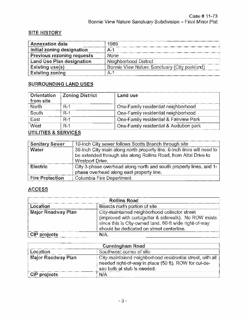
SITE HISTORY
Annexation date
Case # 11-73 Bonnie View Nature Sanctuary Subdivision Final Minor Plat
1969 Initial zoning designation A-1 Previous rezoning requests None Land Use Plan designation Neighborhood District g~isting users) Bonnie View Nature Sanctuary (City parkland) g~il>ting zoning A-1
SURROUNDING LAND USES
Orientation Zoning District Land use from site
.~ ---
North R-1 One-Family residential neighborhood --------------------------------~~ .... -
South R-1 One-Family residentiCllneighborhood East R-1 One-Family residential & Fairview Park
i West R-1 One-Family residential & Audubon park
UTILITIES & SERVICES
Sanitar::l Sewer 1Q:irl(;~gity sewer follows Scotts Branch through site Water 36-inch City main along north property line. 6-inch lines will need to
be extended through site along Rollins Road, from Altai Drive to Westport Drive.
Electric i City 3-phase overhead along north and south property lines, and 1-i phase overhead along east property line .
Fi re Protection • Columbia Fire Department
ACCESS
Rollins Road /-cL",o~c:a,.c;.t,-:::io:,-n,--:-----:=-____ ~s north portion of site-=: ___ ~
Major Roadway Plan City-maintained neighborhood collector street (improved with curb/gutter & sidewalk). No ROW exists since this is City-owned land. 60-ft wide right-of-way should be dedicated on street centerline.
CIP projects • N/A.
~~ ________ -,-==C:..:u::-n,-,-n:.::in,,-,gham Road L~ocation • Southwest corner of site . Major Roadway Plan • City-maintained neighborhood residential street, with all
I CIP projectsJ~1~?:~~~~t~;~~~w~iS~a~~e~i~~%~~~=~~e~(~50-ft~).~R~O~W_f~or~c~u~I-~de~-_-j
•

Location Major Roadway Plan
CIP projects
Case # 11-73 Bonnie View Nature Sanctuary Subdivision - Final Minor Plat
Weaver Drive South side of site City-maintained neighborhood residential street, with all needed right-of-way in place (50 ft). ROW for cul-de-sac bulb at stub is needed. N/A
Unnamed street (off Westport Drive) Location East side of site Major Roadway Plan City-maintained neighborhood residential street, with all classification needed right-of-way in place (50 ft). ROW for cul-de-
sac bulb at stub is needed. CIP projects N/A
PARKS & RECREATION
Neighborhood Parks Plan Site is home to Bonnie View Nature Sanctuary. Parking area, shelter, and bathroom facilities are planned on north side of park, with access from Rollins Road roundabout.
Trails Plan Scott Branch Greenway is planned through the park, with connections to adjacent neighborhood streets. Several existing dirt and grass paths provide pedestrian access to the site's interior.
Bicycle/Pedestrian Network Existing pedway along south side of Rollins Road. Plan
Report prepared by_-'C~_"#I---,---___ Approved bY---,r,--J2~~'--?f ___ _
- 4 -

.~ Case No. 11-73: Bonnie View Nature Sanctuary
Subdivision - Aerial o 210 420 840
Feel

~.
SUBJEC SITE
Case No. 11-73: Bonnie View Nature Sanctuary Subdivision Natural Features

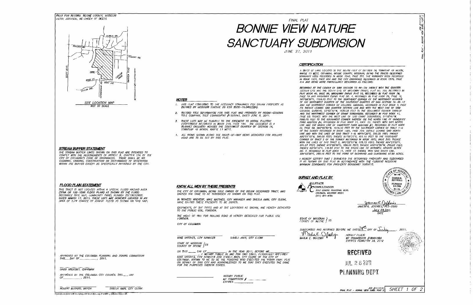
fiLEO FOR RECORD, BOONE: COUNTY. MiSSOURI BEmE JOHNSON, RECORDER OF D££OS,
51 ~
~
SITE: LOCATION MAP NOT TO SCALE
STREAM BIFEER STAIEJ.ENT
f«iiliNS RO,
I ~ ~
THE STREAM BUFFER UMfTS SHOWN ON THIS PLAT ARE INTENDED TO COMPt Y WITH THE REOU!REMENTS OF ARTICLE X, CHAPTER 12A OF nlE CrTY OF COWMB/A'S CODE OF ORDINANCES. THERE SHALL 8£ NO ClEARINC. CRADING, CONSTRUCTION OR D1SroRBANCE OF vEGUAnON WITHIN THE BUFFER EXCEPT AS SPECIFlCALLY APPROVED BY THE CITY.
B.OOD PI..A.N STAIEJ.ENT nilS TRACT IS NOT i.OCATEO WffHlN A SPEClAt FLOOD HAZARD AREA (SFHA OR tOO~YEAR FLOOD PLAiN) AS SHOWN BY THE FLOOD INSURANCE RATE MAP. GDMMUNITY PANEL NUMBER 29019C0260D, OATED MARCH 17, 201 I. THE:SE LOTS ARE HOWEVER LOCATED (N AN AREA OF 0.2% CHANCE OF ANNUAL flOOD AS SNOWN ON SAID MAP.
APPROVEO BY COl UMBIA PlANN!NG AND ZONiNG COUMISSfON miS_DAY v, ____ , 2011.
OAWD BROOSl(Y, CHAIRMAN
APPROVEO BY THE COLUMBIA C{!Y COUNCiL THIS _ OAr OF ____________________ , 20' I,
SHEElA AldiN.. CITY CLERK
FINAL PLAT
BONNIE VIEW NA TURE SANCTUARY SUBDIVISION
JUNE 27, 2011
I.
2.
3.
1.
;HIS PLAT CONFORMS TO THE ACCURACY srANDARDs FOR URBAN PROPER'1Y AS DEfINED BY MISSOURI SIAMT 20 CSR 2OJD~ 16.O<O(2)(A).
RECORD rfTl.E fNFORMATlON FOR THIS PLAT W~ PROVIDED BY BOONE-CENTRAL nnE COMPANY, nnE COMMITMENT 11102841, OAlED JUNE 9, 20 fl.
;HESE LOTS MAY BE SUBJECT TO THE EASEMENT TO BOONE ELECTRfC COOPERATIVE RECORDED IN BOOK 218, PACE 164, THE EASEMENT IS A BlANKEJ EASEMENT ACROSS THE SOUTHWEST OUARTER OF SECnON '6, TOWNSHIP 48 NORTH, RANCE 13 WEST,
ALL fRONS SHOWN ALONG T1iE RiGHT-·OF-WAY BEING DEDICATED FOR ROLUNS ROAD ARE TO BE SET BY T1iIS PLAT.
KNQWA!.J. MEN BY TI-ESE F'RESBfl'S THE: CfTY OF COUlMBIA. BONG soLE owNER OF THE BELOW OESCRIBED TRACr. HAS CAusro THE SAME TO BE SUBDMDED AS SHOWN ON IHIS PLAT.
IN WITNESS WHEREOf. MIKE MAITHES. Cirt MANAGER AND SHEELA AMIN, CiTY CLERK, HAVE CAUSED THESE PRESENTS TO 8£ SIGNED.
EASEMENTS, OF THE TYPES AND AT THE L0G4TlONS AS SHOWN, ARE HEREBY DEDICATED TO THE PUBLIC USE, FOREVER,
THE RIGHT-Or~WAY FOR ROLLINS ROAD IS NEREBY DEDICATED FOR PU8LJC USE FOREVEf/.
CfTY OF cOLUMBIA
MIKE MATTHES, CITr' MANAGER
STATE OF MISSOURI Jss COUNTY OF BOONE
SHEElA AMIN, CITY ClERK
oN mlS __ DAY OF , IN mE YEAR 20ft, BEFORE 1.1£.,;-;;'7<=""'''''' im~=rur<'C' A NOTARY PUBLIC IN AND FOR SND STATE, PERSONALLY APP£AR£O MIKE MATTHES, CITY MANAGER AND SHEELA AM/N, CITY CLERK OF THE CITY OF COLUMBIA. KNOWN TO ME TO 8E mE PERSONS WHO EXECUTED mE WITHIN ANAL PLAT ON BEHALF OF SNO CITY MD ACKNOWLEDGED TO ME THAT THE'( EXECUTEO THE SAME FOR THE PURPOSES THEREIN STATEO.
NOTARY PUBLfC
MY COMM",ISS::ION~/~=~-EXPIRES _
A rPAcr OF LAND LOCArm .W THE soum HALF OF SECTION 16, TOWNSHIP 413 NOfffl{,
PANC£ f.J WEST, COWMBIA BOONE COuNTY, MiSSOURI, B£!NG THE TRACTS DESCRf8ff) WARRANtY DEED RECORD£O IN BOOK 1047, PACE 377, THE WAREWIlY OLEO Rt-COHDE!) IN BOOK 1231, PACE 954 AND THE CITY ORDINANCE RECORDED fN BOOK 1576, PACE 414 A.ND BEING MORE PART/COURtY OESCR/BEl) AS FOLL Oil'S:
BECfNNtNC AT mE CENTER OF SAID SECTiON 16~4B- f.3; THENCE WlTl-f THE QUMT'ER SECTION UNE /WD THE SOVlH UNE: OF BROADWAY FARMS, PLAT NO. I~, RECORDED IN PLAr BOOK 40, PAGE 98, BROADWAY FARMS PlH f5. RECORDEO IN pur BOOK J6, PACE 58 AND BRClWWAY FARMS pr.Ar NO, 4, RECORDED IN PLAT BOOK 25. PAGE 12, S8.J'58'50"E, 1.3(6.25 FEU TO mE NORTHEAST CORNER OF THE NORTHFAST QUARTfR OF THE NORTHWEST OUARTER OF THE SOUTHEAST QUARTER OF WV SECTION 16··48---13 AND mE NORTHWEST CORNER OF COLONIAL GARDENS. RE:COROED IN PLAT BOOK 7. PACE 73; THENCE LEAViNG S;4,'D QUARTEft SECTION UNE AND wrm THE WEST LINE or SAiO COLONIAL GARDENS, SO·52'JO"W. 1530.95 fFIT TO THE: SOUTHWEST CORNER THEREOF AND mE NORTHWEST CORNER OF CRANT SUBDMSlON, RECORDED IN PlAT BOOX 1 t, PACE 93; THENCE iWTH THE: WEST UHE OF SAW CfWff SU80fV1SfON, Sf'05'45"W, 108D.70 FEIT ro THE SOUTHWEST CORNER THEREOF ON THE NORTH UNE or UN/VERsrrt PARK ADDInON 14, RECORDED fN PLAT BOOK 11, PACE 21; mENCE WITH SAlO NORm UNE AND mE NORTH UNE OF UHf\l[RSITY PARK ADofllON /7, R£COROED IN PLA T BOOK 12, PACE 68, H82'46'50"W, 10f9.10 FEU TO THE SOUTHEAST CORNER OF TRACT 1-B OF THE SURVEY RECORDED IN BOOK 188/, PACE 774; THENCE LCAVINC SAID NORTH UNE AND WITH THE LiNES OF SAID TRACT l-B, NO'54'J5"E, J!j{),J5 FffTi THENGE N82'5J'f5"W. 300.05 FEET; THENCE N1'oo'25"E, 601.10 FEU TO mE SOUTHCAST CORNER OF TRACT 2 Of THE SURVEY RECORDED IN BOOK '572, PACE J05,' THENCE wrm THE UNES OF SAlO TRACT 2, N8S·22'55"W. 575.7J fEU: THENCE N24'28'OO"£, 551.27 FEG; mENGE Nf5'28'OO»E~ 650,00 FEfTj THENCE NfO'02'OO~W. J50.OJ FrrT; THENCE N4'S6'10"£ '.J9.84 fEIT TO mE SOUTH ONE OF ROTHWELL HflCHTS BLOCK NO.7, RECORDEO IN PLA T BOOK I', PACE 17; THENCE WITH SAID soum UNE, S84'02'oo"E, 250. /6 FEU TO THE POINT OF BEGINNING ANO CONTAJNlNC 87.99 ACRES.
I HEREBY CERrtFY THAT J SURVEYED THE D£SCRJ8ED PROPERTY ANI) SU80MOED fT AS SHOWN ON THiS PLAT IN ACCORDANCE WJTH THE CURRENT MJSSOURI MINIMUM STANDARDS FOR PROPER'1Y BOUNDARY SURVEYS.
SWVEYAlf) PLATBr
ONSULTANTIl &1:LSTATE
3.)/2 LEMONt: INfJUSfflIAL B(vv. COLUJ.tiJ'.A, W$SOIJ8f 63201 (SlJ) 81!H)199
STATE: OF MISSOURI J SS COUIfIY OF BOONE
J.'t Z3,2011 DAlE
SUBSCRIBED AND AFFIRMED BeFORE ME mlsd~ vAY OF,T~
~G~;~ 7ZT~:"':iffi~ 108490598 EXPIRES FEBRUARY 28. 2012
RECEIVED JUL :! 8 2011
PlANNI!~G DEPT
, 2011.

FILm FOR RECORD, BOONE COUNTY. WSSOUf,} BEmE JOHNSON, RECORDER OF DEWS,
SC.A/I: /" _ 100' ----o 50 100
BEARINGS ARE RllFRENCED ro CRiD NORTH FROM THE MiSSOURI STATE PlANE COORDINATE SYSTDI, CENrRAL ZONE, F/?OU CPS OBSERVATIONS USiNG GRS MO/,/UUENr 80-/5 AS REFERENCE.
~)
FINAL PLAT
BONNIE VIEW NA TURE SANCTUARY SUBDIVISION
APfflQXiw,rr; A'?E4 OF 0.2X CHM'CE OF ANHWJ. F1.00(J
(SEE n(}()l) f>L.VN STATfJ.lENr)
"
RECEIVED
st.mWAlCJ EL4TBY