iee offshore md-04 block pdf 3 mb
TRANSCRIPT

eni Myanmar
Date
September
2015
Document n.
rep HSE 004 2015
eni Myanmar r00
Page
1 of 72
This document is property of eni spa who will safeguard its rights according to the civil and penal provision of the law.
Myanmar offshore Block MD-4
Initial Environmental Examination (IEE)

eni Myanmar
Date
September
2015
Document n.
rep HSE 004 2015 eni Myanmar
r00
Page
2 of 72
TABLE OF CONTENTS
1 EXECUTIVE SUMMARY .................................................................................... 8
2 PROJECT CONTEXT AND MOTIVATION ............................................................ 9
2.1 PROJECT PROPONENT ................................................................................... 11 2.1.1 eni S.p.A. general information .................................................................... 11 2.1.2 eni Upstream HSE integrated management system .................................... 12
2.2 PROJECT CONSULTANT .................................................................................. 13 2.2.1 Amec Foster Wheeler ................................................................................. 13 2.2.2 eGuard Environmental Services .................................................................. 14
2.3 REPORT STRUCTURE ..................................................................................... 18
3 LEGAL AND INSTITUTIONAL FRAMEWORK ................................................... 19
3.1 INTRODUCTION ............................................................................................ 19 3.2 INSTITUTIONAL CONTEXT............................................................................. 20 3.2.1 Administrative Structure Overview ............................................................ 20
3.3 OVERVIEW OF PERMITTING PROCESS AND AUTHORITIES INVOLVED ........... 21 3.3.1 Environmental Conservation Law, Law No. 9/2012, 30th March 2012 ....... 21 3.3.2 Draft Environmental Impact Assessment Procedure .................................. 22 3.3.3 Myanmar Investment Commission Notification 50/2014............................ 24
3.4 INTERNATIONAL CONVENTIONS AND AGREEMENTS SIGNED BY MYANMAR .. 24 3.5 ENI ENVIRONMENTAL, SOCIAL AND HEALTH POLICIES ................................ 26
4 PROJECT DESCRIPTION ................................................................................ 28
4.1 LOCATION OF THE SURVEYS ......................................................................... 28 4.2 MORPHOLOGY OF THE AREA .......................................................................... 29 4.2.1 Coordinates of MD-4 Block ......................................................................... 30
4.3 SEISMIC DATA REPROCESSING ACTIVITIES ................................................. 31
5 ENVIRONMENTAL, SOCIAL AND HEALTH DESCRIPTION ............................... 34
5.1 STUDY AREA IDENTIFICATION ...................................................................... 34 5.2 CLIMATE AND OCEANOGRAPHY ..................................................................... 35 5.2.1 Water Mass Circulation ............................................................................... 35 5.2.2 Storm Surge ............................................................................................... 36
5.3 AIR QUALITY CHARACTERIZATION ............................................................... 36 5.4 GEOLOGY....................................................................................................... 37 5.5 SEAWATER QUALITY ..................................................................................... 38 5.6 WASTE MANAGEMENT ................................................................................... 40 5.6.1 Local Waste Management System .............................................................. 40
5.7 PROTECTED AREAS AND BIODIVERSITY ........................................................ 41 5.7.1 Protected Areas and Areas Important for Biodiversity ............................... 41 5.7.2 Endemic Fauna and Protected Species ....................................................... 46 5.7.2.1 Coral Reefs ........................................................................................... 46 5.7.3 Endemic Flora and Threatened Species ...................................................... 47
5.8 SEASCAPE ..................................................................................................... 48 5.9 DEMOGRAPHIC FACTORS AND SOCIAL DETERMINANTS ................................ 53 5.9.1 Societal structure ....................................................................................... 53 5.9.2 Social relationships and the local power structure ..................................... 56
5.10 WELFARE ....................................................................................................... 56 5.10.1 Educational system ............................................................................... 56 5.10.1.1 Pre-primary education ....................................................................... 56

eni Myanmar
Date
September
2015
Document n.
rep HSE 004 2015 eni Myanmar
r00
Page
3 of 72
5.10.1.2 Primary education .............................................................................. 57 5.10.1.3 Secondary education .......................................................................... 57 5.10.1.4 Higher education ................................................................................ 57
5.11 FACILITIES ................................................................................................... 59 5.11.1 Social infrastructure (transport, roads, electricity, water and
communications) ............................................................................................. 59
5.12 ECONOMY ...................................................................................................... 61 5.12.1 Main economic sectors and sensitive issues ......................................... 61 5.12.2 Main economic sectors .......................................................................... 61
5.13 NATIONAL HEALTH ACCOUNTS ...................................................................... 61 5.13.1 Health expenditure ............................................................................... 61 5.13.1.1 Background ........................................................................................ 61
5.14 HEALTH CARE DELIVERY SERVICES ............................................................... 62 5.14.1 Health sector ........................................................................................ 62 5.14.1.1 Public ................................................................................................. 62 5.14.1.2 Private ............................................................................................... 62 5.14.2 Health referral system .......................................................................... 63 5.14.2.1 Primary care ...................................................................................... 63 5.14.2.2 Secondary care .................................................................................. 63 5.14.2.3 Tertiary care ...................................................................................... 63 5.14.3 Human resources for health .................................................................. 63 5.14.4 Health financing outlines: mechanisms of funding health care ............. 64 5.14.5 Health infrastructures and medical equipment ..................................... 64
6 ENVIRONMENTAL IMPACTS ASSESSMENT AND MITIGATION MEASURES ..... 66
7 CONCLUSIONS.............................................................................................. 67
REFERENCES ......................................................................................................... 68
LIST OF TABLES
Table 3-1: International Conventions/Agreements ...................................................................... 25
Table 4-1: Main characteristics of the Block MD-4 ....................................................................... 29
Table 4-2: Block MD-4 plane coordinates (WGS 84) .................................................................... 30
Table 5-1: Recent observed surges (Department of Hydrology and Meteorology of Myanmar et Al., 2009) ........................................................................................................ 36
Table 5-2: Characteristics of Marine Protected Areas (Source: WDPA and (BOBLME, 2015)) ............. 42
Table 5-3: Myanmar population by sex and region (MIP, 2014) .................................................... 53
Table 5-4: Trend in pre-school attendance in public and private institutions (IBE-UNESCO, 2011) .... 57
Table 5-5: Ministries and the number of associated tertiary educational institutions (MOE, 2007) ..... 58
Table 5-6: Health professionals in Myanmar from 1988 to 2011. (MoH, Ministry of Health, 2014b) ... 64
Table 5-7: Health facilities in Myanmar from 1988 to 2014. (MoH, Ministry of Health, 2014b) .......... 65

eni Myanmar
Date
September
2015
Document n.
rep HSE 004 2015 eni Myanmar
r00
Page
4 of 72
LIST OF FIGURES
Figure 2-1: MD-4 Block location ................................................................................................ 10
Figure 2-2: eni spa in the world (Source: eni) ............................................................................ 11
Figure 2-3: eni Upstream main exploration activities in the world (Source: eni 2015) ...................... 12
Figure 3-1: The Governmental Structure in Myanmar .................................................................. 20
Figure 3-2: IEE Process Flow Diagram ....................................................................................... 23
Figure 4-1: Location of MD-4 Block ........................................................................................... 28
Figure 4-2: Geological division of Myanmar Offshore (Myint, 2015) ............................................... 29
Figure 4-3: Bathymetric chart of the offshore area (GEBCO, 2014) ............................................... 30
Figure 4-4: MD-4 Block base map ............................................................................................. 33
Figure 5-1: Study area identification (MD-4 Block) ...................................................................... 34
Figure 5-2: Surface marine currents during (a) February and (b) August, (Rizal Syamsul, 2012) ...... 36
Figure 5-3: Annual average concentration of PM10 in residential areas of selected cities in Asia (Ohnmar May Tin Hlaing et Al., 2014) ................................................................. 37
Figure 5-4: MD-4 Block area geology (eni, 2015) ........................................................................ 38
Figure 5-5: Ports of Myanmar (www.mpa.gov.mm) ..................................................................... 40
Figure 5-6: Marine Protected Areas (Designed, Potential and Proposed Protected Areas according to WDPA and Ross Island – Shark Protected Area). (Source: AMEC elaboration from WDPA and (BOBLME, 2015)) ...................................................................... 42
Figure 5-7: Marine Protected Areas near MD-4 Block (Source: AMEC elaboration from WDPA and (BOBLME, 2015)) ............................................................................................. 43
Figure 5-8: Conservation corridor locations (WCS, 2013) ............................................................. 45
Figure 5-9: Coral reef (UNEP-WCMC, WorldFish Centre, WRI, TNC, 2010) ...................................... 47
Figure 5-10: Yetagun Field (Source: http://www.offshoreenergytoday.com/myanmar-annual-maintenance-at-yetagun-gas-field/).................................................................... 48
Figure 5-11: Myeik (or Mergui) archipelago (TMC, 2012) ............................................................. 49
Figure 5-12: Coral Reef distribution map (UNEP-WCMC, WorldFish Centre, WRI, TNC, 2010)............ 49
Figure 5-13: Characteristics of coastline (Source: Google Earth) ................................................... 51
Figure 5-14: Protected areas .................................................................................................... 52
Figure 5-15: High Priority KBAs ................................................................................................ 52
Figure 5-16: Percentage of population living in urban areas in the different states/region (MIP, 2014) ............................................................................................................. 54
Figure 5-17: Percentage of population by state/region (MIP, 2014) ............................................... 55
Figure 5-18: List of states/regions with population per square kilometre indicated (MIP, 2014) ........ 55
Figure 5-19: Household sizes by state/region in Myanmar (MIP, 2014) .......................................... 56
Figure 5-20: International ports in Myanmar (KPMG, 2013) ......................................................... 59
Figure 5-21: Public recurrent and capital costs by regions and states (MoH, Ministry of Health, 2014b) ............................................................................................................ 62

eni Myanmar
Date
September
2015
Document n.
rep HSE 004 2015 eni Myanmar
r00
Page
5 of 72
ACRONYMS AND ABBREVIATIONS
AIU Atlantic International University
ASEAN Association of Southeast Asian Nations
CIA Central Intelligence Agency
DICA Directorate of Investment and. Company Administration
DoF Department of Fisheries
DOH Department of Health
ECC Environmental Compliance Certificate
ECD Environmental Conservation Department
ECL Environmental Conservation Law
ESH Environmental, Social and Health components
ESHIA Environmental, Social and Health Impact Assessment
EIA Environmental Impact Assessment
EEZ Exclusive Economic Zone
EMP Environmental Management Plan
ESHIA Environmental, Social and Health Impact Assessment
ESHMP Environmental, Social and Health Management Plan
ESIA Environmental and Social Impact Assessment
EU European Union
FAO Food and Agriculture Organization
FIL Foreign Investment Law
GHG Green House Gas
GRT Gross Register Tonnage
HIV Human immunodeficiency virus
IBA Important Bird Area
IBAT Integrate Biodiversity Assessment Tool
IBE International Bureau for Education
IEE Initial Environmental Examination
IFC International Finance Corporation
ILO International Labour organization
IPIECA International Petroleum Industry Environmental Conservation Association
ISA International Seabed Authority
IUCN International Union for Conservation of Nature
KBAs Key Biodiversity Areas
MARPOL MARine POLlution
MIC Myanmar Investment Commission

eni Myanmar
Date
September
2015
Document n.
rep HSE 004 2015 eni Myanmar
r00
Page
6 of 72
MIDC Myanmar Industrial Development Committee
MMCWA Myanmar Maternal and Child Welfare Association
MOAI Ministry of Agriculture and Irrigation
MOE Ministry of Energy
MOECAF Ministry of Environmental Conservation and Forestry
MOEP Ministry of Electric Power
MOGE Myanmar Oil and Gas Enterprise
MOH Ministry of Health
MOHT Ministry of Hotels and Tourism
MOI Ministry of Industry
MOM Ministry of Mines
MOST Ministry of Science and Technology
MPA Myanmar Port Authority
MRCS Myanmar Red Cross Society
NGO Non-Governmental Organization
OECD Organization for Economic Cooperation and Development
OGP Oil & Gas Producers
OHD Occupational Health Division
PAM Passive Acoustic Monitoring
PM Particulate Matter
PSC Production Sharing Contract
RHC Rural Health Centre
SIA Social Impact Assessment
STI Sexually Transmitted Infections
TNC The Nature Conservancy
TOR Term of Reference
UNCRD United Nations Centre for Regional Development
UNDP United Nations Development Programme
UNEP United Nations Environment Programme
UNESCO United Nations Educational, Scientific and Cultural Organization
UNFPA United Nations Population Fund
UNHCR The UN Refugee agency
WCMC World Conservation Monitoring Centre
WCS Wildlife Conservation Society
WDPA World Database on Protected Areas
WEPA Water Environment Partnership in Asia

eni Myanmar
Date
September
2015
Document n.
rep HSE 004 2015 eni Myanmar
r00
Page
7 of 72
WHO World Health Organization
WRI World Resources Institute
WTTC World Travel and Tourism Council

eni Myanmar
Date
September
2015
Document n.
rep HSE 004 2015 eni Myanmar
r00
Page
8 of 72
1 EXECUTIVE SUMMARY
The present Initial Environmental Examination study (IEE) has been conducted to identify
potential impacts of the re-processing 2D seismic data for the MD-4 Block area.
The MD-4 Block is located in Andaman Sea nearly 210 km from the Burmese coast; it has an
extent of 5,900 km2 and is characterized by a water depth varying from 1,000 to 2,200 m.
The aim of the project is existing seismic data reprocessing, consisting only of office analysis
through specific software. During Study period on-site activities will not be carried out.
Currently the seismic survey is not object of the present study, if in the future eni will proceed
to first exploration period a dedicated IEE will be developed regarding these activities.
Based on the activities foreseen, an IEE is not required according to law regulations; however,
in order to respect the PSC provision, a dedicated study has been provided in the present
document.
After a review of the legal and policy framework, a baseline description of the environmental,
social and health components of the wider area of interest has been provided. Since the MD-4
Block is located offshore, the baseline description has focused in particular on marine aspects
(marine fauna, water quality) and on the potential interferences with maritime activities (fishing
and maritime commerce, water pollution). Nevertheless, an analysis of the onshore environment
along the coast has also been carried out.

eni Myanmar
Date
September
2015
Document n.
rep HSE 004 2015 eni Myanmar
r00
Page
9 of 72
2 PROJECT CONTEXT AND MOTIVATION
On March 26th 2014 eni Myanmar BV in Joint Venture with PetroVietnam (eni 80% - PetroVietnam
20%) was awarded the offshore MD-4 Block in Myanmar.
The Production Sharing Contract (PSC) for MD-4 Block was signed on March 31st, 2015.
MD-4 has the following characteristics:
Block MD-4
o Location: Andaman Sea (see Figure 2-1);
o Area: about 5,900 Km2; and
o Water depths: 1000-2,200 m range.
Based on PSC commitments, the first activity eni Myanmar is going to perform is the re-
processing of 1,850 km of existing 2D seismic data within MD-4 in the Study Period.
The PSC requires an Environmental Impact Assessment (EIA), Social Impact Assessment (SIA)
and Environmental Management Plan (EMP) to be completed within six months of the Effective
Date (the Preparation Period).
Based on the activities foreseen, applicable environmental regulations do not request a specific
study, however an IEE has been prepared in order to respect the PSC provision.
Currently the seismic survey is not object of the present study, if in the future eni will proceed
to first exploration period a dedicated IEE will be developed regarding these activities.
An IEE is “[…] a study comprising a systematic assessment of a proposed activity or project that
is prepared to aid in determining whether such activity or project has the potential significantly
to affect the environment, humans and other living things, including socio-economic impacts,
and in deciding whether such activity or project should be allowed or not. The form, content and
structure of the report shall be in accordance with the Ministry’s requirements and guidelines
and international best practice, and include the EMP” (Source: Ministry of Environmental
Conservation and Forestry of Myanmar).
The present study is the IEE Report for the activities planned in the Study Period for MD-4
Block.
The IEE Report has been prepared in accordance with Myanmar regulations, in compliance with
the following eni Upstream Standards, and in line with the following International standards and
guidelines:
Ministry of Environmental Conservation and Forestry, 2013, “Environmental Impact
Assessment”, draft version (not yet formally approved);
eni e&p Standard 1.3.1.47 “Environmental, Social and Health Impact Assessment” and
revision of eni e&p Standard 1.3.1.47 ‘Annex B’, May 2013 “Environmental, Social and
Health Impact Assessment – Annex B”;
eni e&p Technical Guide AMTE-TG 191 “Guideline for Offshore Environmental Monitoring
Activities”;
eni e&p Operating Instruction hse 002 ep r01 “Minimum HSE requirements in Geophysical
Operations”;
eni Health Profile Index 6 eni e&p Document SVI.VMS.GL.004 - Stakeholder
Management;
IFC Performance Standards, Jan 1, 2012 “IFC Performance Standards on Environmental
and Social Sustainability”;
IPIECA, 2011 “Indigenous Peoples and the Oil and Gas Industry”;
IPIECA, 2010 “Alien invasive species and the oil and gas industry”;

eni Myanmar
Date
September
2015
Document n.
rep HSE 004 2015 eni Myanmar
r00
Page
10 of 72
International Convention for the Prevention of Pollution from Ships, 1973, as modified by
the Protocol of 1978 - Annex I-VI.
Figure 2-1: MD-4 Block location
The qualitative evaluation has been based on secondary data sources, including:
General assumptions based on provisional survey design provided by eni Upstream;
Data provided by National and Local Authorities/Agencies, Scientific Institutions,
Universities and any other relevant Government Organizations/Institutions;
Data provided by other bibliographic sources and databases;
Information from previous environmental, social and health studies carried out within the
project’s potential areas of influence; and
Information from international and regional agencies / Non-Governmental Organization
(NGOs) / United Nations Development Programme (UNDP) / United Nations Environment
Programme (UNEP) / European Union (EU) / Central Intelligence Agency (CIA) / World
Bank / voluntary association present in the area.
The elaboration of the above data has allowed to analyse the relationships between the project
and its environmental, social and health context and to determine whether the project may
cause significant environmental, social and health impacts.

eni Myanmar
Date
September
2015
Document n.
rep HSE 004 2015 eni Myanmar
r00
Page
11 of 72
2.1 PROJECT PROPONENT
2.1.1 eni S.p.A. general information
eni S.p.A. is an integrated energy company, active in 85 countries in the world with a staff of
approximately 82,300 employees.
Its corporate culture and business model are the successful factors that make eni one of the
major players in the activities of exploration and production of oil and natural gas, generation
and marketing of electricity, petrochemicals, engineering and construction.
eni is divided in Upstream and Mid-Downstream divisions: eni Upstream services include oil &
gas exploration, field development and production.
eni operates on a global scale as shown in the figure below:
Figure 2-2: eni spa in the world (Source: eni)
eni Upstream division operates in the countries shown below:

eni Myanmar
Date
September
2015
Document n.
rep HSE 004 2015 eni Myanmar
r00
Page
12 of 72
Figure 2-3: eni Upstream main exploration activities in the world (Source: eni 2015)
eni is a socially responsible actor and contributes to the economic development of the countries
where it operates.
Sustainability is an integral part of eni's governance model and represents the motor of a
continuous improvement process that contributes to the achievement of the business targets.
In the deployment of its activities, eni built important relations with the external world in order
to maintain a constructive confrontation aimed at the diffusion and development of best
practices.
This approach is based on the respect of universal principles such as the protection of human
rights, the adoption of the highest standards of work, the respect of the environment and
communities. The respect for universal principles incorporated in eni's business model is
expressed mainly in responsibility towards applicable laws and the adoption of best standards,
the inclusion of all its people through fair and non-discriminating policies, excellence in
operations with the adoption of quality systems and advanced technologies.
Integration, innovation and cooperation are the competitive drivers allowing eni to stand out in
the oil & gas industry.
2.1.2 eni Upstream HSE integrated management system
eni Upstream division adopted, implemented and constantly updated its own Health, Safety,
Environment Public Safety, Quality and Radiation Protection Integrated management system
(HSE IMS), since 1998.
The eni Upstream division’s HSE IMS has been developed, and constantly updated, to comply
with the international standards concerning environmental management (ISO 14001), health
and safety (OHSAS 18001), quality (ISO 9001), and social accountability (SA 8000); eni
Upstream is also involved in all the major initiatives in the HSE area being an active participant
of international organizations as OGP and IPIECA.
eni is committed to sharing information and experience for the continual development of industry
standards and improved practices for health, safety and environmental protection.
This has allowed eni Upstream to develop a strong culture on the HSE issues.

eni Myanmar
Date
September
2015
Document n.
rep HSE 004 2015 eni Myanmar
r00
Page
13 of 72
The eni Upstream division’s HSE IMS operates according to the Deming cycle method, in order
to guarantee a continuous improvement of the associated activities; in particular, the HSE
process is composed of four sub-processes:
Planning;
Implementation and operation;
Checking and corrective actions; and
Management review.
For each of the abovementioned sub-processes, the HSE IMS identifies and describes their
inherent phases with their characteristics and the main operating modalities, as well as the
associated roles and responsibilities.
At present, eni Upstream division head quarter holds the following certificates:
ISO 14001:2004 for “Strategic and operational planning and projects development in
hydrocarbon exploration and production”, starting from 2005;
OHSAS 18001:2007 for ”Strategic/operational planning and project development of
hydrocarbon exploration and production operations. Testing, analysis and
measurement activities aimed at characterization of hydrocarbon” issued in 2010;
ISO 9001:2008 for “Survey Design, Acquisition and Processing of Geophysical Data”
starting from 2002;
ISO 9001:2008 for “Planning and Development of Radiation Protection Services,
Radioecological Surveying, NORM Surveying, Dosimetry, Radiometric Analyses,
Training, Electromagnetic Field Evaluation” starting from 1999.
About eni Upstream controlled companies, more than 25 subsidiaries hold their own ISO14001
certificate and the OHSAS 18001 one.
Further information on eni’s activities is available on eni’s website (www.eni.com).
2.2 Project Consultant
Amec Foster Wheeler E & I GmbH and eGuard Environmental Services are the consultancy
services companies who gave support to eni for IEE development.
2.2.1 Amec Foster Wheeler
Amec Foster Wheeler is a focused supplier of consultancy, engineering and project management
services to its customers in the world's oil and gas, minerals and metals, clean energy,
environment and infrastructure markets. The company has a highly skilled workforce of more
than 40,000 employees and operations in over 50 countries, providing a complete service from
consultancy, project management, project delivery, to long-term asset support services,
together with leading-edge technologies and products, to customers wherever they are in the
world.
Amec Foster Wheeler has have an extensive and growing network of operations across the Asia
Pacific region and a track record that includes projects in almost every country in the region
(Myanmar; Brunei Darussalam, China, India, Indonesia, Malaysia, Singapore, South Korea,
Thailand and Vietnam). The company has numerous offices in Southeast Asia
(http://www.amecfw.com/aboutus/offices) and about 2,000 people involved in the O&G sector
in the region.
Abstracts from the CVs of the professionals involved are provided below.
Paolo Pucillo (Environmental Scientist/Project Manager)
Mr. Pucillo has over 13 years of environmental engineering and consulting experience. His areas
of expertise include Environmental, Social and Health Impact Assessment (ESHIA),

eni Myanmar
Date
September
2015
Document n.
rep HSE 004 2015 eni Myanmar
r00
Page
14 of 72
Environmental and Social Management Plans, integrated site closure programs, industrial sites
investigation / remediation, and multinational clients service management. He has also
performed Phase I environmental site assessments, and compliance and due diligence audits,
as well as Phase II soil and groundwater investigations for Italian and multinational industrial
clients. His applied experience includes designing and implementing ecological monitoring
programs and sustainable management planning, and encompasses projects related to offshore
oil development within and beyond Italian waters.
Vincenzo Nappa (Environmental Scientist/Project Specialist)
Mr. Nappa has over 10 years of experience in environmental consulting projects. His areas of
expertise include environmental, social and health impact assessment, environmental
permitting, and legislative review. He has worked as a Project Consultant for numerous private
O&G clients and has been involved in several ESHIA studies, including site surveys. Additionally,
he has extensive experience in environmental multi-site due diligence, including asbestos-
containing material sampling and surveys. Mr. Nappa is OPITO-certified.
Eduardo Missoni (Health and Social Expert Supervisor)
Mr. Missoni has 30+ years of professional experience in Health and Social Development and
International Cooperation. For 15 years, as a health and social development adviser to the Italian
Directorate General for Development Cooperation, he was in charge of development programs
(including identification, appraisal, implementation, monitoring and evaluation) in Latin America
and the Caribbean, and Sub-Saharan African countries. Since 2002 he has been an adjunct
professor for Global Health and Development at Bocconi and Bicocca University in Milan, Italy,
and at the Geneva School of Diplomacy in Geneva, Switzerland. During this time he has also
accomplished a significant number of consultancy projects with private and public partners,
including supervising health impact evaluations and planning of community mitigation and
development
Luca Galazzo (Environmental Consultant)
Mr. Galazzo has over five years of environmental engineering and consulting experience. His
areas of expertise include ESHIAs, soil and groundwater remediation (environmental
investigations, sanitary risk analysis, remediation plant installation and post-operam
monitoring), wastewater treatment plants design and waste management.
Mr. Galazzo has extensive experience in coordinating and conducting ESHIAs, with activities
ranging from pre-site-visit reviews to on-site surveys.
Mr. Galazzo has performed numerous legislative reviews pertaining to permitting projects,
including identification of legislative requirements, development of permitting applications and
interaction with the competent authorities during the review and approval processes.
Mr. Galazzo has proven experience on conducting stakeholder engagement processes regarding
their opinion on social and environmental issues in order to improve decision-making and
accountability. He has performed ESHIA projects for O&G exploration and production activities
in several locations, including Loango (Congo), Ukraine, Gabon, Myanmar, Malerbina (Italy), and
Cyprus. Mr. Galazzo also has proven experience in conducting ESHIAs related to nuclear
decommissioning activities in Italy.
2.2.2 eGuard Environmental Services
eGuard was founded in March 2013 when ECD (Environmental Conservation Department) of
MOECAF announced the requirement of EIA/SIA studies as a requirement for classified projects
in early 2013. It was successfully registered and incorporated under the Myanmar Company Acts
as a limited company on July 31st, 2013, Company Registration no. is 2110 (2013-2014).
Founders of eGuard are devoted to the environmental conservation and protection works. They
all had worked and trained abroad and blessed with the international experiences and had
exposures with environmental consulting firms. Founded with some countable number of key
staffs, the company is growing rapidly in capital, equipment and human resources together with

eni Myanmar
Date
September
2015
Document n.
rep HSE 004 2015 eni Myanmar
r00
Page
15 of 72
the demand of the market. The company has been employing new blood of environmental
scientists and engineers breeding them in house while working with their seniors and
international consultants.
After draft Environmental Impact Assessment study procedure was introduced by the
Environment and Conservation Department (ECD) in 2013, eGuard has worked for her clients
needing EIA/SIA studies in various projects type and sizes.
The EIA/SIA studies is inclusive of the following:
Screening, Scoping, EIS review;
Environmental Assessment/Baseline Survey;
Flora-Fauna Survey/Baseline Study;
Socio-Economic Survey/Baseline Survey;
EIA/SIA Studies;
Environmental Management Plans (EMP);
Environmental Education and Capacity Building;
Environmental Monitoring.
eGuard’s professional team is composed as follow.
Professional Role on project Skills
Aye Thiha Senior Project Coordinator B.Sc. (Forestry) Institute of Forestry,
Yezin, Myanmar.
M.Sc. (Natural Resources Management),
Asian Institute of Technology, Bangkok,
Thailand.
Dip in Computer Studies (Yangon
University).
Saw Win Senior Consultant
B.Sc. (Forestry), Yangon University,
Yangon, Myanmar.
Grad, Dip. Science (Forestry), ANU,
Australia,
ISO/14001:2004 Auditor, ISO
9001:2000 Auditor,
IEMA (UK) Environmental Management
Training Certificate
Soe Min Environmental Consultant
B.E. (Civil), Rangoon Institute of
Technology, Yangon, Myanmar.
M.E (Environmental Technology
Management), Asian Institute of
Technology, Bangkok, Thailand.
Dr. Khine Yi
Mya
Senior Consultant B.Sc. (Hons.) (Chemistry), M.Sc.
(Chemistry), Yangon, Myanmar.
M.Sc. (Polymer Science), Ph.D.
(Polymer Science), Chulalongkorn
University in Collaboration with
University of Michigan, University of
Oklahoma and Case Western Reserve
University of Ohio.

eni Myanmar
Date
September
2015
Document n.
rep HSE 004 2015 eni Myanmar
r00
Page
16 of 72
Myat Mon Swe
Energy Consultant B.Ag., Yezin Agricultural University,
M.Sc. (Engg. EEM)
Dept. of Energy and Environmental
Management, University of Flensburg,
Flensburg, Germany,
Dip. of GIS/RS, Yangon University,
Yangon, Myanmar
Yinn Mar Swe
Hlaing
Environmental Consultant
B. Agri, Sc. Yezin Agricultural University,
M.Sc., Graduate School of Agricultural
and Life Sciences, The University of
Tokyo,
Post Graduate Diploma in English
University of Foreign Languages,
Mandalay.
Nan Kham Syne Environmental Engineer
Consultant
B.Sc. (Hons.) (Industrial Chemistry)
Dagon University, Myanmar
M.Sc. (Environmental Engineering and
Management) Asian Institute of
Technology, Bangkok, Thailand
Myo Thet Tin
Environmental Consultant
B.Agr.Sc., Yezin Agricultural University,
M.Sc. (Regional and Rural Development
Planning), Asian Institute of Technology,
Bangkok, Thailand
Thet Mhue Khin
Civil Engineer Consultant B.E (Civil Engineering), West Yangon
Technological University, Myanmar
M.E (Environmental Engineering),
Yangon Technological University,
Myanmar.
Yar Kyaw Shein
Geotechnical Consultant Master of Engineering (Geotechnical and
GeoEnvironmental Engineering), Asian
Institute of Technology (AIT), Bangkok,
Thailand.
Diploma in Construction Engineering,
BCA Academy, Singapore (Part-time),
M.Sc. (Geology), University of Yangon,
Yangon, Myanmar
B.Sc. (Hons.) (Geology), Dagon
University, Yangon, Myanmar
Ms. Saw Zar Chi
Geologist Specialist B.Sc. (Hons) (Geology),
M.Sc. (Regional Geology)
Hinthada University.
Toe Toe Kyaw
Lin
Geologist Specialist B.Sc. (Hons) (Geology),
M.Sc. (Regional Geology)
Aye Mya Mon
Legal Specialist LL.B (Law)

eni Myanmar
Date
September
2015
Document n.
rep HSE 004 2015 eni Myanmar
r00
Page
17 of 72
Dr. Phyo Naing
Zay
Social & Health Consultant M.B.,B.S., University of Medicine (2),
Yangon
Post graduate Diploma in Environmental
Management and Planning, Yangon
Technological University
Diploma in Business Administration
(Thames), Informatics Academy,
Yangon
Diploma in International Relations,
University of Yangon
Prof. U Nyo
Maung
Natural Scientist Consultant B.Sc. (Hons) Botany, Mandalay
University
M.Sc. (Taxonomy)
Prof. U Maung
Maung Aye
Geologist Specialist B.A (Hons), Yangon University
M.A (1st Class Degree) in
Geomorphology
James Cook University, Australia
Prof. Dr. Myint
Thaung
Biodiversity Consultant Dip Ag (Agriculture), B.Ag.
(Agriculture),
M.Agr. St. Entomology
Ph.D. (Insect control)
Matriculated (General Science and
Agriculture)
Dr. Ian
Borthwick
Biologist Consultant Royal Navy University Cadetship
B.Sc. Zoology and Oceanography,
University College Swansea
Ph.D. Oceanography, University College
Swansea, Certified Diploma in
Accounting and Finance -Chartered
Association of Certified Accountants
Prof. Soe Htun
Biologist Consultant B.Sc. (Marine Biology)
M.Sc. (Marine Biology)
Prof. Ohn Win
Environmental Consultant B.Sc. (Forestry), Rangoon Art and
Science University (RASU)
Diploma (Forestry) University of
Philippines
M.Sc. (Watershed Management)
Colorado State University, USA
Dr. Harpon
Phungrassami
Engineer Consultant Ph.D. in Environmental Engineering,
Ajou University
M. Management, University of Southern
Queensland
M. Eng, Asian Institute of Technology,
B. Eng, Thammasat University

eni Myanmar
Date
September
2015
Document n.
rep HSE 004 2015 eni Myanmar
r00
Page
18 of 72
Zay Win Tun
Social-Economist Consultant Master of Economics (Statistics)
2.3 REPORT STRUCTURE
The present study is structured as follows:
Legal and institutional framework (chapter 3);
Project description (chapter 4);
Environmental, Social and Health description (chapter 5);
Environmental Impacts Assessment and mitigation measures (chapter 6);
Conclusions (chapter 7).

eni Myanmar
Date
September
2015
Document n.
rep HSE 004 2015 eni Myanmar
r00
Page
19 of 72
3 LEGAL AND INSTITUTIONAL FRAMEWORK
3.1 INTRODUCTION
A synopsis of the environmental, social, health and health & safety regulatory framework that is
considered relevant to the project activity is presented below.
Environmental laws in Myanmar are in their infancy and the main piece of environmental
legislation in the form of the Environmental Conservation Law was only enacted in 2012. The
Draft Environmental Impact Assessment Procedure is currently awaiting parliamentary approval
(6th draft version). When the present report has been elaborated (September 2015), no formal
approval has been notified.
This paragraph reports a list of main laws applicable to the Environmental, Social and Health:
Environmental Legislative and Institutional Framework:
Environmental Conservation Law (ECL 2012);
Prevention from Danger of Chemicals and Associated Materials Law, No.28/2013
(PDCAML 2013);
Foreign Investment Law (2012);
Wildlife & Protected Areas Law 1994 (WPAL 1994);
Myanmar Investment Commission Notification 50/2013;
Public Health Law (1972);
Penal Code (1961);
Water Pollution Guidelines (1994);
Industry Standing Order N. 3/1995;
City of Yangon Development Law (CYDL 1990);
ASEAN Marine Water Criteria (AMWQC 2012);
Union of Myanmar Marine Fisheries Law (1990); and
Draft Environmental Impact Assessment Procedure (EIA 2015).
Health Legislative and Institutional Framework:
National Health Policy (1993);
Environmental Health Programme (1993);
National Health Plan (2011-2016);
Public Health Law (1972);
Prevention and Control of Communicable Diseases Law (1995 and revised in 2011);
National Food Law (1997);
Myanmar Medical Council Law (2000);
Factories Act (1951);
Social Security Law (2012);
Employment and Skill Development Law (2013);
Minimum Wage Law (2013);
New Law on Health and safety in the Workplace (due 2015);
Law relating to the Registration of Organizations (2014);
Law relating to Peaceful Assembly and Peaceful Procession (2011); and
Labour Organization Law (2013).

eni Myanmar
Date
September
2015
Document n.
rep HSE 004 2015 eni Myanmar
r00
Page
20 of 72
3.2 INSTITUTIONAL CONTEXT
3.2.1 Administrative Structure Overview
The governmental structure in Myanmar is separated to 3 sections; Government, Regional
Administration and Local Administration as shown in Figure 3-1 below.
Figure 3-1: The Governmental Structure in Myanmar
Myanmar administrative divisions are divided into 21 sub-divisions which include 7 states, 7
regions, 1 union territory, 5 self-administered zones and 1 self-administered division.
Yangon Region has the largest population and the highest density population. Regions and states
are divided into districts. Each district consists of townships which include towns and village-
tracts (a group of adjacent villages).
The main government agencies responsible for administrating oil and gas exploration and
production activities in Myanmar are the:
Ministry of Energy (MOE) - the coordinating body for all types of energy in Myanmar, and
in charge of the Oil and Gas sector;
Myanmar Oil and Gas Enterprise (MOGE) - responsible for exploration/production and land
transmission of oil and gas, and to oversee Production Sharing Contracts (PSC) entered
into with foreign investors;
Ministry of Environmental Conservation and Forestry (MOECAF) – responsible for
environmental protection and managing the environmental and social impacts of projects.
MOECAF’s responsibilities include reviewing and approving a project developers ESIA
Project Proposal, ESIA Scoping Study, Environmental and Social Impact Assessment report
and Environmental and Social Management and Monitoring Plan report. Oil and gas

eni Myanmar
Date
September
2015
Document n.
rep HSE 004 2015 eni Myanmar
r00
Page
21 of 72
exploration projects cannot commence until MOECAF has issued an Environmental
Compliance Certificate (ECC);
Myanmar Investment Commission (MIC) – responsible for scrutinising investors proposals
made under the Foreign Investment Law (2012), granting investor privileges and issuing
investment permits. The MIC has a duty to consider environmental and social impacts when
considering project proposals;
Ministry of Health (MOH) is the primary government agency responsible for the health of
Myanmar’s citizens. The MOH is responsible, amongst other things for; developing and
implementing government health care policies and plans, providing public health care
infrastructure and services, regulating health care providers (public and private) controlling
communicable diseases and compiling and reporting health statistics;
Department of Health (DOH) within the Ministry of Health is responsible for occupational
and environmental health protection in Myanmar. This department deals with the
prevention of adverse health effects due to air and water pollution, toxic and hazardous
wastes and chemical safety. The Occupational Health Division (OHD), part of the Public
Health Department (PHD), within the DOH is responsible for health promotion in work
places, environmental monitoring of work places, biological monitoring of exposed workers
and health education on occupational hazards.
3.3 OVERVIEW OF PERMITTING PROCESS AND AUTHORITIES INVOLVED
In accordance with Chapter 6, Article 67 of the Draft Environmental Impact Assessment
Procedure and the MIC Notification 50/2014 dated 14th August 2014; project proponents
proposing oil and gas exploration activities are required to prepare an Environmental and Social
Impact Assessment for the Project for submission to the (MIC, the Environmental Conservation
Department (EIA Division) at MOECAF and MOGE for their review and approvals prior to the
issuance of an Environmental Compliance Certificate (ECC). A brief synopsis of the primary
legislation and regulation related to the Environmental and Social Impact Assessment process
in Myanmar is presented below.
3.3.1 Environmental Conservation Law, Law No. 9/2012, 30th March 2012
Despite drafting an environmental policy in 1994, there was no recognized environmental law in
Myanmar until The Environmental Conservation Law (ECL) was enacted in 2012. The
Environmental Conservation Law contains 14 chapters that define the rights and responsibilities
of the Ministry of Environmental Conservation and Forestry which includes; environmental
quality standards, environmental conservation, management in urban areas, conservation of
natural and cultural resources, process for businesses to apply for permission to engage in an
enterprise that has the potential to damage the environment, prohibitions, offences and
punishments.
Under Article 7 (m) the ECL states that the Ministry has duties and powers with respect to
implementing a system of environmental impact assessment and social impact assessment as
to whether or not a project or activity to be undertaken by any Government department,
organization or person may cause a significant impact on the environment. It is confirmed by
Articles 52 and 53 of the Rules (Environmental Conservation Rules, 5th June 2014) that says all
Projects undertaken in the Republic of the Union of Myanmar by any ministry, government
department, organization, corporation, board, development committee, local government or
authority, company, cooperative, institution, enterprise, firm, partnership or individual having
the potential to cause significant Adverse Impacts, are required to undertake IEE or EIA and to
obtain an ECC in accordance with this Procedure.
Article 18 states that relevant Government departments and Government organizations shall
carry out the conservation, management, beneficial use, sustainable use etc., of natural
resources. MOECAF shall cooperate with the relevant Government departments and Government

eni Myanmar
Date
September
2015
Document n.
rep HSE 004 2015 eni Myanmar
r00
Page
22 of 72
organizations for the preservation of cultural heritage areas, natural heritage areas, cultural
monuments, and natural areas.
Articles 22 – 25 allow the Ministry to establish a prior permitting scheme for businesses that
may cause significant environmental harm by prescribing categories of business that require a
permit for the activity which may also come with prescribed and binding conditions.
3.3.2 Draft Environmental Impact Assessment Procedure
The Ministry of Environmental Conservation and Forestry (MOECAF) has drafted an
Environmental Impact Assessment Procedure to implement the EIA aspects of the Environmental
Conservation Law.
Legislation related to environmental assessment, conservation and protection in Myanmar is
currently within a development phase for approval prior to being submitted to parliament for
ratification. Presently, the MOECAF is drafting both EIA Procedures and EIA Guidelines, along
with the supporting of an EIA drafting committee comprising the representatives of relevant
union ministries, union attorney general’s office, development committees and NGOs and
technical support by experts from the Asian Development Bank Greater Mekong Region –
Environment Operations Centre (ADB GMS-EOC).
The Environmental Impact Assessment Procedure aims ‘to establish a system of environmental
impact assessment which shall require any proposed project or business or activity or
undertaking in Myanmar by any ministry, government department, organization, corporation,
board, development committee, local government or authority, company, cooperative,
institution, enterprise, firm, partnership or individual having the potential to cause significant
Adverse Impacts to undertake either an IEE [Initial Environmental Examination] or an EIA and
to obtain an Environmental Compliance Certificate (ECC) in accordance with the Procedure’.
Although the guidelines are still in a draft status, the approach of this Project has been aligned
with the latest draft version (Version 6) which was made publically available in 2015.
Following the IEE approach is provided.

eni Myanmar
Date
September
2015
Document n.
rep HSE 004 2015 eni Myanmar
r00
Page
23 of 72
Figure 3-2: IEE Process Flow Diagram

eni Myanmar
Date
September
2015
Document n.
rep HSE 004 2015 eni Myanmar
r00
Page
24 of 72
3.3.3 Myanmar Investment Commission Notification 50/2014
The Myanmar Investment Commission Notification 50/2014 dated 14th August 2014, under
power of section 56(b) of the Foreign Investment Law (FIL), lists the economic activities
requiring environmental impact assessments. Activities listed include; ‘exploration, drilling and
production of oil and gas’. The MIC also has a duty to consider environmental and social impacts
when considering project proposals and a synopsis of the relevant requirements under the FIL
is presented below:
Article 8l states that the investment shall be allowed based on the ‘protection and conservation
of the environment’.
Article 12a states that the duties of the Commission include taking into consideration the facts
such as and protection and conservation of environment in scrutinising the proposals of
investment.
Article 17h states that the duties of the investor will include not causing environmental pollution
or damage in accordance with existing laws.
If the Project Proponent is applying for an Investment Permit under the FIL then the Project
Proponent will also be required to issue copies of the aforementioned ESIA reports to the MIC
for their review.
3.4 INTERNATIONAL CONVENTIONS AND AGREEMENTS SIGNED BY MYANMAR
This section reports main conventions and agreements pertaining with the project activities
ratified by the Country.
The Union of Myanmar is a Signatory or Party to the following international conventions and
protocols:
The Kyoto Protocol (KP) 1997;
Memorandum of Understanding on the Conservation and Management of Marine Turtles
and their Habitats of the Indian Ocean and South-East Asia, 2001;
The Ramsar Convention, 1971;
Stockholm Convention on Persistent Organic Pollutants, 2001;
The Declaration on the Rights of Indigenous Peoples (document A/61/L.67) adopted by
UN General Assembly, 2007;
Asia Least Cost Green House Gas Abatement Strategy (AGAS), 1998;
Convention on Biological Diversity, 1992;
Convention on Climate Change, 1992;
International Convention on the Prevention of Pollution from Ships, 1973 as modified by
the protocol of 1978 (MARPOL 73/78) with the exceptions of Annex III (packaged
substances), Annex IV (sewage), Annex V (garbage) and Annex VI (air pollution);
Montreal Protocol on Substances that Deplete the Ozone Layer, 1989;
Vienna Convention for the protection of the Ozone Layer, 1988; and
United Nations Convention on Law of the Sea, 1986.
The descriptions of the domain of action of these international conventions/agreements are
summarized in Table 3-1.
eni Myanmar
Date
September
2015
Document n.
rep HSE 004 2015 eni Myanmar
r00
Page
25 of 72
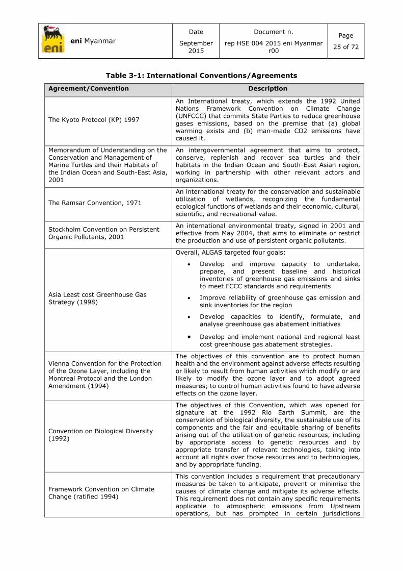
Table 3-1: International Conventions/Agreements
Agreement/Convention Description
The Kyoto Protocol (KP) 1997
An International treaty, which extends the 1992 United Nations Framework Convention on Climate Change (UNFCCC) that commits State Parties to reduce greenhouse
gases emissions, based on the premise that (a) global warming exists and (b) man-made CO2 emissions have caused it.
Memorandum of Understanding on the
Conservation and Management of Marine Turtles and their Habitats of
the Indian Ocean and South-East Asia, 2001
An intergovernmental agreement that aims to protect,
conserve, replenish and recover sea turtles and their habitats in the Indian Ocean and South-East Asian region,
working in partnership with other relevant actors and organizations.
The Ramsar Convention, 1971
An international treaty for the conservation and sustainable utilization of wetlands, recognizing the fundamental ecological functions of wetlands and their economic, cultural,
scientific, and recreational value.
Stockholm Convention on Persistent
Organic Pollutants, 2001
An international environmental treaty, signed in 2001 and effective from May 2004, that aims to eliminate or restrict the production and use of persistent organic pollutants.
Asia Least cost Greenhouse Gas Strategy (1998)
Overall, ALGAS targeted four goals:
Develop and improve capacity to undertake, prepare, and present baseline and historical inventories of greenhouse gas emissions and sinks to meet FCCC standards and requirements
Improve reliability of greenhouse gas emission and sink inventories for the region
Develop capacities to identify, formulate, and analyse greenhouse gas abatement initiatives
Develop and implement national and regional least
cost greenhouse gas abatement strategies.
Vienna Convention for the Protection
of the Ozone Layer, including the Montreal Protocol and the London
Amendment (1994)
The objectives of this convention are to protect human health and the environment against adverse effects resulting
or likely to result from human activities which modify or are likely to modify the ozone layer and to adopt agreed
measures; to control human activities found to have adverse effects on the ozone layer.
Convention on Biological Diversity (1992)
The objectives of this Convention, which was opened for signature at the 1992 Rio Earth Summit, are the conservation of biological diversity, the sustainable use of its
components and the fair and equitable sharing of benefits arising out of the utilization of genetic resources, including by appropriate access to genetic resources and by appropriate transfer of relevant technologies, taking into account all rights over those resources and to technologies, and by appropriate funding.
Framework Convention on Climate Change (ratified 1994)
This convention includes a requirement that precautionary measures be taken to anticipate, prevent or minimise the causes of climate change and mitigate its adverse effects. This requirement does not contain any specific requirements applicable to atmospheric emissions from Upstream operations, but has prompted in certain jurisdictions

eni Myanmar
Date
September
2015
Document n.
rep HSE 004 2015 eni Myanmar
r00
Page
26 of 72
Agreement/Convention Description
legislative developments, which have affected such activities.
United Nations Convention on Law of the Sea (ratified 1986)
This convention provides a comprehensive, legal regime for the world’s seas and oceans.
Agenda 21 of the United Nations
conference on Environment and Development UNCED, 1992
Upstream activities are addressed through provisions in Chapter 17:30 which calls for measures to control degradation of the marine environment from sea-based activities. Coastal States are called upon to assess existing
regulatory measures regarding pollution from offshore oil and gas platforms.
MARPOL 73/787
The International Convention for the Prevention of Pollution from Ships is one of the few global conventions prescribing quantitative environmental standards for operational aspects of offshore Upstream activities. This convention contains:
Annex I (Prevention of Pollution by Oil).
Annex II (Control of Pollution by Noxious Liquid substances in Bulk).
Annex III (Prevention of Pollution by Harmful Substances Carried by Sea in Packaged Forms or in
Freight Containers, Portable Tanks or Road and Rail Tank Wagons).
Annex IV (Regulations for the Prevention of Pollution from Sewage from Ships).
Annex V (Prevention of Pollution by garbage from Ships).
Annex VI (Prevention of Air Pollution from Ships).
3.5 ENI ENVIRONMENTAL, SOCIAL AND HEALTH POLICIES
eni has developed specific guidelines and standards for its operations that will be met during project activities as far as practicable. A summary of main guidelines pertaining the social, health and environmental aspects are included below:
eni Usptream Division – Quality Requirements: this document defines the contractor’s
Management System requirements to be applied to the Contract Scope of Work during
the bid stage and during the execution of works.
eni Usptream Division - Contract HSE Requirements for abroad services (Rev 01, Aug
2010): Sets out the minimum requirements, as well as recommendations for everything
relevant to the Health, Safety & Environment aspects of the project.
eni Usptream Division – HSE Standard Doc N° 1.3.4.04 “Environmental & Social Impacts
in E&P Operations” (2010), including its updated Annex 2 on Biodiversity and Ecosystem
Service (BES). This technical guideline describes the purpose and the basic steps to
identify appropriate contents, relevant methodologies and responsibilities for the
preparation and the implementation of an ESHIA.
eni Usptream Division, Circular 498 9.12.2008, “Community Investment Management
System Best Practice (with particular reference to Annex 1 “Stakeholder Management
Process” and Annex 2 “Social baseline Analysis”)”. It establishes best practice principles
for the stakeholder management process and for the social baseline analysis.

eni Myanmar
Date
September
2015
Document n.
rep HSE 004 2015 eni Myanmar
r00
Page
27 of 72
eni Usptream Division – HSE Standard Doc. N° 1.3.4.01 “Identification of significant
environmental aspects”. It sets the standards relevant to the methodology for the
identification of significant environmental aspects.
eni Usptream division- Doc N° 1.3.2.11 MHS 2 “Health Risk Assessment”.
eni Usptream division- Doc N° 1.3.4.05 “Waste Management planning”. It provides a set
of minimum requirements and treatment options that shall be considered for the
preparation of dedicated local-specific procedures for a correct management of all wastes,
including waste-water, drilling waste and TENORM waste produced during e&p activities.
eni standard on Air Quality Monitoring (doc No. 1.3.4.07). It provides a guide or the
design, installation and management of Air Quality Monitoring Systems.
eni standard on Water Management (doc No. 159). It defines the procedure for proper
and sustainable water management, thus resulting in a usable instrument both for design
and operational phases. Moreover it is conceived to be a guideline to develop a Water
Management Plan.
eni Minimum HSE Requirements in Geophysical Operations (opi sg hse 002 e&p r01). It
defines the minimum HSE requirements to apply in geophysical operations (including land
sesmic acquisition and processing, gravity and magnetic survey) in order to ensure
compliance with the commitments of eni spa Policies as well as the requirements of
internationally recognized best practices.
eni Code of Ethics (Mar 2008): Lays out eni’s Code of Ethics for its operations
eni Guidelines on the Protection and Promotion of Human Rights (Apr 2007).
Moreover eni Upstream refers to some international policies, principles, and standards for its
activities; the main of them are listed below:
OGP/IPIECA - Ecosystem services guidance, 2011;
International Union for Conservation of Nature (IUCN) Red List;
International Finance Corporation (IFC) – Performance Standard 6 Biodiversity
Conservation and Sustainable Management of Living Natural Resources, 2012;
International Finance Corporation (IFC) – Performance Standard 7 Indigenous People,
2012;
International Finance Corporation (IFC) – Stakeholder Engagement: A Good Practice
Handbook for Companies Doing Business in Emerging Markets, 2007;
WHO – World Health Organization;
OGP/IPIECA - A Guide to Health Impact Assessment for oil and gas industry, 2007;
International Convention for the Prevention of Pollution from Ships, 1973, as modified by
the Protocol of 1978; Annex I-VI.

eni Myanmar
Date
September
2015
Document n.
rep HSE 004 2015 eni
Myanmar r00
Page
28 of 72
4 PROJECT DESCRIPTION
This section reports a general overview of MD-4 Block area and a description of seismic data re-
processing.
The 2D seismic survey is not object of the present project, if in the future eni will proceed to
first exploration period a further IEE will be developed for these activities.
4.1 LOCATION OF THE SURVEYS
The project study area will be located offshore of Myanmar in the Block MD-4. The MD-4 Block
is located 140 nautical miles (260 km) West of Myeik and 240 nautical miles (445 km) South of
Yangon.
Figure 4-1: Location of MD-4 Block
The Myanmar Offshore area can be geologically divided into five provinces (see the sketch map
below):
Rakhine Basin;
Moattama Basin;
Tanintharyi Shelf;
East Andaman Basin; and
Mergui Ridge.
Yangon
MyeikMD-4

eni Myanmar
Date
September
2015
Document n.
rep HSE 004 2015 eni
Myanmar r00
Page
29 of 72
Figure 4-2: Geological division of Myanmar Offshore (Myint, 2015)
The project will be performed over an area within the Moattama basin encompassed in the central
Andaman Sea back arc depression with other two basins namely the Andaman Sea, and the
Mergui Basins.
4.2 MORPHOLOGY OF THE AREA
The following table shows the geographical characteristics of the MD-4 Block.
Table 4-1: Main characteristics of the Block MD-4
Block Bathymetry Range (m) Surface Area (km2) Minimum Distance to Myanmar Coast (km)
MD-4 1000-2200 5,900 210
The Figure 4-3 shows the bathymetry map of area (GEBCO, 2014).

eni Myanmar
Date
September
2015
Document n.
rep HSE 004 2015 eni
Myanmar r00
Page
30 of 72
Figure 4-3: Bathymetric chart of the offshore area (GEBCO, 2014)
4.2.1 Coordinates of MD-4 Block
The geographical coordinates of Block MD-4 are provided in the following table. The coordinates
are reported using the geographic coordinate system WGS 84.
Table 4-2: Block MD-4 plane coordinates (WGS 84)
BLOCK MD-4
Point ID E N
0 95°36’49,263” 13°0’2,335”
1 96°17’54,015” 13°0’2,335”
2 96°17’54,015” 12°18’57,583”
3 95°30’4,602” 12°18’20,796”
4 95°41’43,562” 12°53’54,462”
eni Myanmar
Date
September
2015
Document n.
rep HSE 004 2015 eni
Myanmar r00
Page
31 of 72
4.3 SEISMIC DATA REPROCESSING ACTIVITIES
According to the PSC the work program of eni Myanmar during the Study Period is the re-
processing of the legacy 2D seismic data. Eni Myanmar will seek to apply new and advanced
techniques with the main expected seismic data processing objectives are:
Generate good imaging of the targets;
Improve Signal-to-Noise ratio at the reservoir interval;
Enhancement of both spatial and vertical resolution aimed to the improvement of the
imaging, particularly on the targets, in order to provide a suitable input for a good
structural interpretation;
Preservation of amplitude for Direct Hydrocarbon Indicators (DHI) identification and
characterization. Near, Mid and far offset volumes for Amplitude Versus Offset (AVO)
analysis and interpretation will be produced.
The main Geophysical challenges are:
Noise attenuation;
Signal enhancement;
Water bottom and inter-bed multiples attenuation;
Amplitude preservation for AVO studies;
Cable and Source de-ghosting.
Eni Myanmar will reprocess several 2D seismic lines through Anisotropic Pre Stack Time
Migration, acquired offshore Myanmar as specified below:
FIRM program: (26) twenty-six lines for approximately 2,100 km full fold (MD-4 Block),
The lines are part of a larger dataset acquired by CGGVeritas on behalf of Petronas Carigali
Overseas Sdn. Bhd. during the offshore seismic survey 2010.
Between Mid-May and End of June 2010, Marine Vessel Veritas Voyager (CGG Veritas Asia Pacific
Ltd) acquired 65 2D lines over the MD-4, MD-5, MD-6 offshore Myanmar Blocks for a total of
about 5,500 Km, with the following acquisition parameters:
SOURCE PARAMETERS:
o Source Type: Tuned Bolt Airgun Array
o Number of Source Arrays: 4
o Source Volume: 4350 cu. In.
o Source Pressure: 2000 psi
o Source Depth: 6 m
o Shot Point Interval: 37.5 m
STREAMER PARAMETERS:
o Streamer Length: 9900 m
o Number of Streamers: 1
o Streamer Depth: 7 m
o Number of Receiver Groups: 792
o Receiver Group Interval: 12.5 m

eni Myanmar
Date
September
2015
Document n.
rep HSE 004 2015 eni
Myanmar r00
Page
32 of 72
o Nominal Near Offset: 185.6 m
INSTRUMENT PARAMETERS:
o Instrument Type: SEAL 5.1 24-bit
o Recording Format: SEG D 8058
o Record Length: 12 s
o Sample Interval: 2 ms
o Low Cut Filter: 3.5 Hz, 12 dB/Oct
o High Cut Filter: 200 Hz, 370 dB/Oct
o Instrument Delay: 50 ms
o Nominal Fold: 132
These data were processed at CGGVeritas Data Processing Center in Kuala Lumpur between June
and November 2010.
The base map of the above mentioned lines is represented below:

eni Myanmar
Date
September
2015
Document n.
rep HSE 004 2015 eni
Myanmar r00
Page
33 of 72
Figure 4-4: MD-4 Block base map

eni Myanmar
Date
September
2015
Document n.
rep HSE 004 2015 eni
Myanmar r00
Page
34 of 72
5 ENVIRONMENTAL, SOCIAL AND HEALTH DESCRIPTION
This chapter discusses the environmental, social and health conditions within the area of the
MD-4 Block in order to provide a general framework of the area nearby MD-4 Block.
The study has been performed based on the collection of available secondary data from a local
and international bibliography and websites.
The most relevant aspects are reported in the following sections.
5.1 STUDY AREA IDENTIFICATION
MD-4 Block is located in the Andaman Sea (see Figure 5-1 below), 210 km offshore in a water
depth ranging from 1,000 to 2,200 m.
Figure 5-1: Study area identification (MD-4 Block)
The Study area is identified as the area that needs to be studied in order to adequately
understand and describe the Baseline likely to be affected by a possible exploration activity. At
a minimum, the Study Area will encompass the Area of Influence, and in some cases it may
extend farther to further establish the context for the Baseline.
The “study area” has been identified considering the region that could be potentially influenced
by seismic activities. The Area of influence is identified as the area within which the Exploration
activity may potentially affect resource/receptor and within which potential impacts should be
assessed.
In order to assess the presence of protected areas and species, a precautionary buffer of 30 km
around the MD-4 Block has been considered as Area of influence.

eni Myanmar
Date
September
2015
Document n.
rep HSE 004 2015 eni
Myanmar r00
Page
35 of 72
5.2 CLIMATE AND OCEANOGRAPHY
Myanmar is located in the monsoon region of Asia; its climate is greatly affected by its geographic
position and its topographical relief. The circulation and transport of heat in the Indian Ocean is
characterized by variable currents; the monsoon of southern Asia, East Africa and northern
Australia interacts strongly with the Indian Ocean. Although the monsoon reversals of wind
direction and rain recur each year, they do so with sufficient variability to create periods of
relative drought and flood in large parts of the surrounding tropics.
Monsoons are defined as a seasonal reversal of surface winds; they have meteorological
significance and are of practical importance with regard to rainfall.
Monsoons determine the climate for most of India, Myanmar, and Southeast Asia.
Myanmar borders the Bay of Bengal and the Andaman Sea with its 2,400 km long coastline is
exposed to multiple natural hazards including cyclones, earthquakes, storms and tsunamis.
The country has been periodically hit by natural disasters; recent major disasters are as follows
(Department of Hydrology and Meteorology of Myanmar et Al., 2009):
Cyclone Komen, in 2015, led to the loss of 39 human lives and more than 200,000
people were affected;
Cyclone Nargis, in 2008, led to the loss of 84,537 human lives, 53,836 missing persons
and damage to property valued at approximately 4.1 billion dollars;
Cyclone Mala, in 2006, led to the loss of 37 lives;
Indian Ocean Tsunami, in 2004, led to the loss 61 lives; and
Taungdwingyi Earthquake (6.8 on the Richter scale), in 2003 led to the loss of 7 lives.
5.2.1 Water Mass Circulation
The water mass circulates from the north Indian Ocean, Bay of Bengal, southwards along the
coast of Myanmar and Thailand as far as southwest of Phuket Island, and then turn to Indian
Ocean (Figure 5-2).

eni Myanmar
Date
September
2015
Document n.
rep HSE 004 2015 eni
Myanmar r00
Page
36 of 72
Figure 5-2: Surface marine currents during (a) February and (b) August, (Rizal
Syamsul, 2012)
In case of accident event in the Block MD-4, the oil spill trajectory could tend to the southwest
in the winter season, to the southeast in the summer season. However, no detailed information
about the local currents in the MD-4 Block is available.
5.2.2 Storm Surge
The coasts of Myanmar are influenced by the water mass circulations mentioned in the previous
section; several surge events have been observed in recent years (see Table 5-1). However the
MD-4 Block is approximately 210 km from the coast.
Storm surge is defined as an extraordinary flooding event due to a storm. It generally occurs
due to waves generated by the strong wind in tropical revolving storms and cyclones. Myanmar,
is a tropical agricultural country; the majority of the population therefore live in the fertile plain
land, which is often inundated by river floods, and in coastal areas, which are exposed to stormy
weather.
Table 5-1: Recent observed surges (Department of Hydrology and Meteorology of
Myanmar et Al., 2009)
Date LANDFALL MAX WIND (M/S) SURGE OBSERVED (M)
4-5-1982 Gwa 70 8.35
10-5-2003 Kyaukpyu 35 3.7
29-4-2006 Gwa 60 7.18
3-5-2008 Pyinsalu 60 4.08
5.3 AIR QUALITY CHARACTERIZATION
There are currently no air quality standards in Myanmar, nor is there advanced technology (or
capacity) for air quality measurement.

eni Myanmar
Date
September
2015
Document n.
rep HSE 004 2015 eni
Myanmar r00
Page
37 of 72
Currently, the focus is mainly on the largest cities, such as Yangon, where air quality is becoming
a visible concern, and pollution monitoring equipment is beginning to be installed in this city
(Figure 5-3).
Figure 5-3: Annual average concentration of PM10 in residential areas of selected
cities in Asia (Ohnmar May Tin Hlaing et Al., 2014)
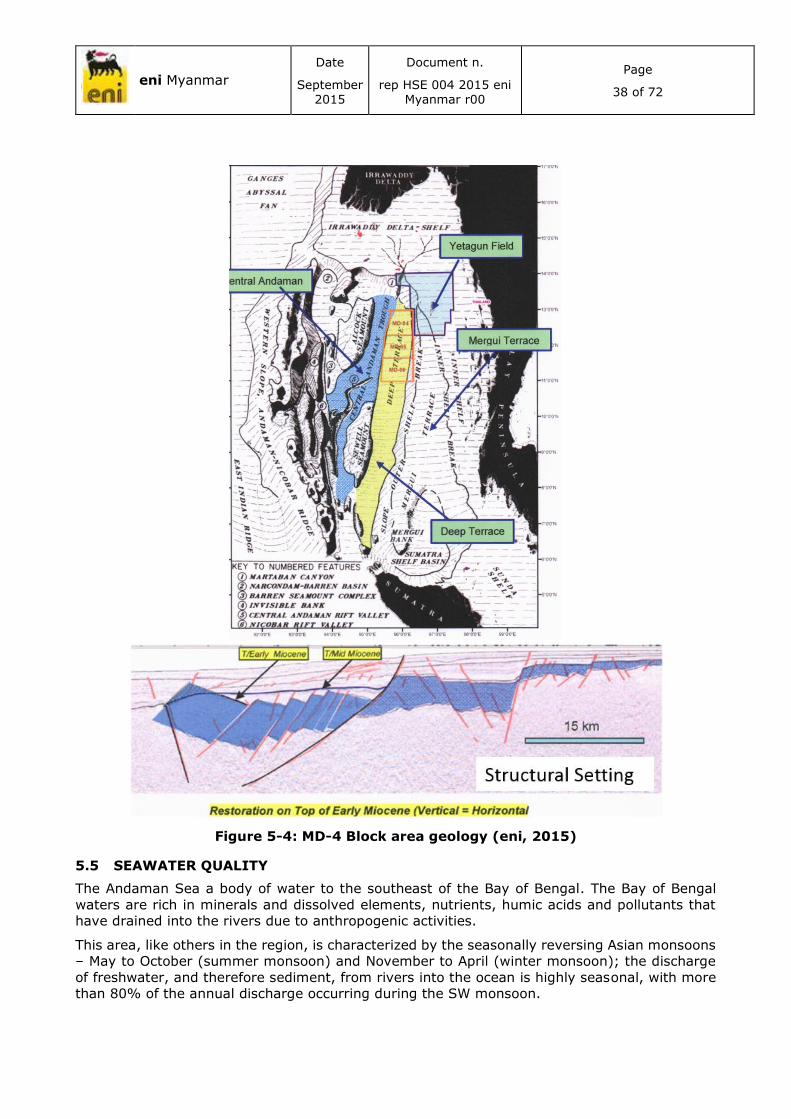
5.4 Geology
MD-4 is located in the Gulf of Martaban in the Moattama/Andaman basin. This basin start its
development in the Oligocene as back-arc basin in the east –west development of the Andaman
rift and was gradually over printed since Mid Miocene by the establishment of a major dextral
shear system along the Sagaing fault zone, getting almost a classic pull apart basin
configuration.
Horst and graben structures developed since Upper Oligocene –Lwr Miocene with the opening of
the Andaman sea; the morphology of the area was dominated by a terrace area (Mergui terrace)
and a main depocenter area (Deep Terrace Zagawa trough). During Middle Miocene the
movement of the Sagaing fault took place and resulted in a deepening of the whole area. Since
Middle Miocene the previous syn rift interval was tilted in a series of easterly dipping faulted
blocks. Inversion structures developed associated with strike slip fault zone, especially along the
Sagaing fault. The overall environment was probably a broad marine shelf were sediments,
coming mainly from N_NE from the Irawaddy Delta, were deposited in compartimentalized
grabens.
eni Myanmar
Date
September
2015
Document n.
rep HSE 004 2015 eni
Myanmar r00
Page
38 of 72
Figure 5-4: MD-4 Block area geology (eni, 2015)
5.5 SEAWATER QUALITY
The Andaman Sea a body of water to the southeast of the Bay of Bengal. The Bay of Bengal
waters are rich in minerals and dissolved elements, nutrients, humic acids and pollutants that
have drained into the rivers due to anthropogenic activities.
This area, like others in the region, is characterized by the seasonally reversing Asian monsoons
– May to October (summer monsoon) and November to April (winter monsoon); the discharge
of freshwater, and therefore sediment, from rivers into the ocean is highly seasonal, with more
than 80% of the annual discharge occurring during the SW monsoon.

eni Myanmar
Date
September
2015
Document n.
rep HSE 004 2015 eni
Myanmar r00
Page
39 of 72
The MD-4 Block is located in the open sea area in Andaman Sea. The MD-4 Block is characterized
by water depths in the range of 1,000-2,200 m: the tidal currents occur at the surface (0-30 m)
and do not affect deep waters.
The Yangon port is located in the Gulf of Martaban.
One characteristic of the Gulf of Martaban is a tide-dominated coastline, called a “macro-tidal”
area, in which the tides range between 4 and 7 m – the highest tidal range is found at the
Elephant Point in the western Gulf of Martaban.
The Gulf is shallow - less than 30 m, and for it, the tidal currents mix the waters and bring the
re-suspended material to the surface. The deeper area beyond 30 m water depth have a different
situation: the gradient of the seafloor increases sharply and the deeper waters do not allow the
tidal forces to re-suspend the sediments and bring them to the surface. Tidal forces become
weaker with increasing distance from the shore (Ramasamy; Rao; Thwin; Raiker, 2004).
When suspended matter concentrations are high, light is unable to penetrate the water column
and the nutrients released from the sediment pore waters are unutilized by the ocean algae.
Adjacent to the brown muddy waters of the Gulf of Martaban the waters are distinctly green due
to high content of chlorophyll in oceanic algae and diatoms. Just before and after the neap tide,
when the tidal range and therefore turbidity of the area is close to its minimum and enough light
is able to penetrate in the seawater, the primary productivity of the Gulf of Martaban is likely to
be very high.
The most important aspect for the economy in Myanmar coastal areas is the shipping activity;
however, this represents a major source of marine pollution (ship-borne and land-based sources
of pollution) (Kyaw Naing, 2011). There are probably over 23,000 fishing boats of various sizes
registered and operating in Myanmar coastal waters.
There are nine ports in Myanmar: Sittwe, Kyauk Phyu, Than Dwe, Pathein, Yangon,
Mawlamyaing, Dawei, Myeik and Kawthoung. Dawei and Myeik ports are the closest ports to MD-
4 Block at a distance of approximately 230-250 km (Figure 5-5).

eni Myanmar
Date
September
2015
Document n.
rep HSE 004 2015 eni
Myanmar r00
Page
40 of 72
Figure 5-5: Ports of Myanmar (www.mpa.gov.mm)
The gradual growth of industries and intensive agriculture influence water quality, particularly
the increase in the use of fertilizers (commonly used fertilizers include urea, triple
superphosphate, muriate of potash etc.), mainly in the Rakhine State and Tanintharyi Region
(Kyaw Naing, 2011).
5.6 WASTE MANAGEMENT
5.6.1 Local Waste Management System
As described in an Atlantic International University (AIU) report (AIU, 2014), Myanmar has
several waste management policies and environment regulations, such as the those contained
in the City of Yangon Development Law (1990), described in the Legal framework (Section 2).
The City or Township Development Committees in each town or city are responsible for
controlling waste management.
According to the United Nations Centre for Regional Development (UNCRD) presentation for the
2nd Meeting of the Regional 3R Forum (“3R” refers to the waste management hierarchy, “Reduce,
Reuse, Recycle”), municipal solid waste in Myanmar is composed mainly of organic waste
(73%) followed by paper/cardboard (18%), wood (4%), plastic and textiles (2% each) and
others (1%) (UNCRD, 2010).
Common problems linked to municipal waste management in Myanmar include the limited
knowledge of technological solutions and processes, limited resources, and poor revenue from
waste collection fees. In particular, in the case of Mandalay, municipal waste management is
impeded by a lack of resources, equipment (e.g. vehicles) and personnel; improper collection
and management of disposal sites, which are mostly run as landfill systems; lack of awareness

eni Myanmar
Date
September
2015
Document n.
rep HSE 004 2015 eni
Myanmar r00
Page
41 of 72
and cooperation from the public; and lack of awareness with regard to solid waste management
practices in general. Nay Pyi Taw has limited facilities, human resources and revenues.
According to the AIU report (AIU, 2014), most of the industrial sites in Myanmar are located
near rivers for reasons of accessibility for both motor vehicles and cargo ships. This has led to
an increase in the potential for environmental degradation. Moreover, some factories discharge
untreated wastewater and/or waste materials into the nearby drainage systems, lands and
rivers.
The Myanmar Industrial Development Committee (MIDC, formed in July 1995) conducts
industrial exhibitions, seminars and conferences promoting industrial growth along with new
technology, including industrial waste management practices. The City Development
Committees are responsible for enforcing, educating and controlling all the industries in their
respective regions in order to prevent water, air and soil pollution and improper handling,
transportation and disposal of hazardous waste, industrial waste or toxic chemicals.
In Myanmar there are a number of wastewater pollution laws, some dealing directly with the
subject, others indirectly. However appropriate standards for both domestic and industrial
wastewater effluent are currently lacking. (WEPA, 2009).
To date no emission value limits are defined in the legislation.
According to a report by WEPA (WEPA, 2009), the only control of water pollution in the country
is through guidelines issued by the Myanmar Investment Commission in June 1994. These
guidelines recommend that new investment projects have wastewater treatment systems.
5.7 PROTECTED AREAS AND BIODIVERSITY
Myanmar has coastline of 2,832 km, which is divided into three regions: the Rakhine region to
the north, adjacent to Myanmar's most prolific shrimp grounds in the Bay of Bengal and
bordering with Bangladesh; the Gulf of Mottama region (or "Ayeyarwady"), in the centre; and
the Tanintharyi region to the south, opposite the 800-island Myeik archipelago of the Andaman
Sea and bordering with Thailand.
The continental shelf spreads over some 228,751 km2, and the exclusive economic zone (EEZ)
has a surface area of almost half a million square kilometres (486,000 km2). The territorial sea
of Myanmar extends 12 nautical miles from the coast line towards the sea and the EEZ covers
all areas of the territorial sea and extend 200 nautical miles seawards from the base line
(BOBLME, Marine Turtle Conservation: Review Report. BOBLME-2011-Ecology-18, 2011).
Myanmar is one of the most biologically diverse country in Asia. This biodiversity is a
consequence of its geographical location, linking Southeast Asia to South Asia and the Himalayas
to the Andaman Sea. (WCS, 2013).
5.7.1 Protected Areas and Areas Important for Biodiversity
According to the Protected Planet website1, in Myanmar there are eight marine protected areas
(five designated, two proposed and one potential). These areas occupy 0.31% of the total
Myanmar marine area (152,595 km2). All eight of these areas are National Protected Areas and
are classified as “partially (coastal) or totally within the marine environment”.
In Table 5-2 below, the characteristics of these areas are listed as well as the locations of Ross
Island (Shark Protected Area) not considered in World Database on Protected Areas (WDPA),
but showed by BOBLME web site (BOBLME, 2015). Figure 5-6 and Figure 5-7 show the location
of designated, proposed and potential protected areas and Ross Island.
1 http://www.protectedplanet.net/

eni Myanmar
Date
September 2015
Document n.
rep HSE 004 2015 eni Myanmar r00
Page
42 of 72
Table 5-2: Characteristics of Marine Protected Areas (Source: WDPA and (BOBLME, 2015))
Name Designation IUCN
category
Marine
area
(km2)
Total
area (km2)
Status Governance Management
authority Management
plan
Moscos Island
Wildlife Sanctuary
IV - 49 Designated 1927 Federal or national ministry or agency
Forest Department Not currently
managed
Thamihla
Kyun (Diamond
Island)
Wildlife Sanctuary
IV - 0.88 Designated 1970 Federal or national ministry or agency
Forest Department Not reported
Mainmahla Kyun
Wildlife Sanctuary
IV - 137 Designated 1993 Federal or national ministry or agency
Nature and Wildlife Conservation
Division
Annual management plan
Lampi Island
Marine National Park
II - 205 Designated 1996 Federal or national ministry or agency
Nature and Wildlife
Conservation Division
Annual management
plant in development
Wunbaik Reserved
Forest Not
reported 228.36 229.19 Designated
not available
Not reported Not reported Not reported
Kadonlay Kyun
Wildlife Sanctuary
Not reported
0.36 2.59 Proposed not
available Not reported Not reported Not reported
Letkokkon Wildlife
Sanctuary Not
reported 1.08 3.88 Potential
not available
Not reported Not reported Not reported
Pakchan Nature Reserve
Not reported
158.64 1,451.9
6 Proposed 1983 Joint management
Joint responsibilities
Not reported
Ross Island
Shark
protected area
- - - - - - - -
Figure 5-6: Marine Protected Areas (Designed, Potential and Proposed Protected Areas according to WDPA and Ross Island –
Shark Protected Area). (Source: AMEC elaboration from WDPA and (BOBLME, 2015))

eni Myanmar
Date
September 2015
Document n.
rep HSE 004 2015 eni Myanmar r00
Page
43 of 72
Figure 5-7: Marine Protected Areas near MD-4 Block (Source: AMEC elaboration from
WDPA and (BOBLME, 2015))

eni Myanmar
Date
September 2015
Document n.
rep HSE 004 2015 eni Myanmar r00
Page
44 of 72
None of these Protected Areas intersects the study area.
According to the IBAT (Integrate Biodiversity Assessment Tool) Database2, in the coastal zone
there are also some Key Biodiversity Areas (KBAs). These sites are identified as a conservation
priority for a variety of species, based on quantitative criteria used for BirdLife's Important Bird
and Biodiversity Areas (IBAs)3.
None of these KBAs and IBAs intersects the study area.
Some conservation corridors have also been identified taking into account areas that maintain
landscape connectivity, maintain connectivity between two or more KBAs, maintain evolutionary
and ecological processes, and safeguard against the potential impacts of climate change.
The figure below shows the locations of the conservation corridors.
None of marine corridors intersect the study area; the nearest is the Taninthayi Marine
Corridor (located at 90 km from study area) that connects the islands of Myeik archipelago and
the Tanintharyi region to the south of the Myanmar.
2 https://www.ibatforbusiness.org/home
3 Important Bird and Biodiversity Area (IBA): A site identified as a conservation priority for bird species based on four criteria: presence of globally threatened species; significant populations of restricted range species; a representative sample of biome-restricted species; important congregations of species. This model of site prioritization was pioneered by BirdLife International and has been used by other organizations to define similarly important sites for other groups of species, culminating in the development of the Key Biodiversity Area concept.

eni Myanmar
Date
September 2015
Document n.
rep HSE 004 2015 eni Myanmar r00
Page
45 of 72
Figure 5-8: Conservation corridor locations (WCS, 2013)

eni Myanmar
Date
September 2015
Document n.
rep HSE 004 2015 eni Myanmar r00
Page
46 of 72
5.7.2 Endemic Fauna and Protected Species
According to the IUCN Red List database and distribution maps downloaded from the IUCN
website, 116 threated marine species are present in the Myanmar sea. They are all native to
Myanmar and have the following IUCN Red List classifications:
Critically Endangered (CR): 3 species;
Endangered (EN): 13 species; and
Vulnerable (VU): 100 species.
Of these, 10 species are present within MD-4 Block study area (considering a 30 km buffer zone),
classified as:
Endangered (EN): 3 species; and
Vulnerable (VU): 7 species.
Furthermore, there are another four turtle species present in the study area (in addition to
Leatherback, Dermochelys coriacea already considered in the 10 species cited above):
Hawksbill turtle, Eretmochelys imbricata (CR), Olive ridley, Lepidochelys olivacea (VU),
Loggerhead turtle, Caretta caretta (EN) and Green turtle, Chelonia mydas (EN). In fact,
despite there are no IUCN distribution map for these species, the IUCN database counts
Eretmochelys imbricata, and Lepidochelys olivacea among the species native to the Burmese
sea. Moreover, based on State of the World's Sea Turtles Online Database (SWOT)4, there are
Caretta caretta, Chelonia mydas and Lepidochelys olivacea nesting beaches along the coastline
of Ayeyarwady Division and Tanintharyi Division, but no turtle tracks have been observed in the
study area (Block area and buffer zone).
The mating season for the whales in the study area generally ranges from November to February
and females usually give birth to a single calf every other year in winter, after a gestation period
of 10.5-12 months.
5.7.2.1 Coral Reefs
In Myanmar, the Rakhine and Tanintharyi coastal areas have conditions that
are favourable for both hard and soft corals. In particular, the offshore
islands of the Myeik archipelago in the Tanintharyi coastal area are
abundantly distributed with diverse coral communities.
Preliminary coral surveys in the Rakhine coastal zone in 2000 and in the
Myeik archipelago, Tanintharyi coastal zone, Deltaic coastal zone in 2001
were conducted by the DoF (Zau Lunn, 2012). The surveys recorded:
51 species in the Rakhine coastal zone;
3 species in the Deltaic coastal zone; and
518 species of hard corals in the Myeik archipelago, Tanintharyi
coastal zone.
The figure below shows the coral reef location (UNEP-WCMC, WorldFish
Centre, WRI, TNC, 2010).
4 The State of the World's Sea Turtles Online Database: Data provided by the SWOT Team and hosted on OBIS-SEAMAP. Oceanic Society, Conservation International, IUCN Marine Turtle Specialist Group (MTSG), and Marine Geospatial Ecology Lab, Duke University. http://seamap.env.duke.edu/swot .

eni Myanmar
Date
September 2015
Document n.
rep HSE 004 2015 eni Myanmar r00
Page
47 of 72
Figure 5-9: Coral reef (UNEP-WCMC, WorldFish Centre, WRI, TNC, 2010)
Coral reefs are self-sustaining; they are resistant to natural impacts such as cyclones and
normally recover to their original state 10 to 20 years after such an event (Myint Pe, no date).
However, coral reefs are generally fragile and susceptible to stress caused by humans such as
dynamite fishing, anchor damage, trampling, over-fishing and sedimentation cause by erosion
from the mainland and from the islands, which buries corals and associated fauna. Myanmar has
implemented laws (the law relating to fishing rights of foreign vessels, 1984, and Myanmar
Fisheries Law, 1990) that prohibit the use of explosives, poison and toxic chemicals, harmful
agents and damaging gears (Myint Pe, no date). Therefore, the main identified threats to corals
are blast and dynamite fishing, illegal bottom trawling near the islands, live fish trading, coastal
zone developments and offshore gas exploration (Zau Lunn, 2012).
5.7.3 Endemic Flora and Threatened Species
According to the IUCN Red List database, three threated marine species are present in the
Myanmar sea. These are all native to Myanmar and have the following IUCN Red List
classifications:
Critically Endangered (CR): 1 species: Sonneratia Griffithii;
Endangered (EN): 1 species: Heritiera Fomes; and
Vulnerable (VU): 1 species: Halophila Beccarii.
None of these 3 species are present within MD-4 Block study area (considering a 30 km buffer
zone).
Note that, according to IUCN Disclaimer, a taxon may not be evenly distributed within the defined
limits of distribution. Ranges, in particular, are mapped as generalized polygons which often
include areas of unsuitable habitat, and therefore a species may not occur in all of the areas
where they are mapped.
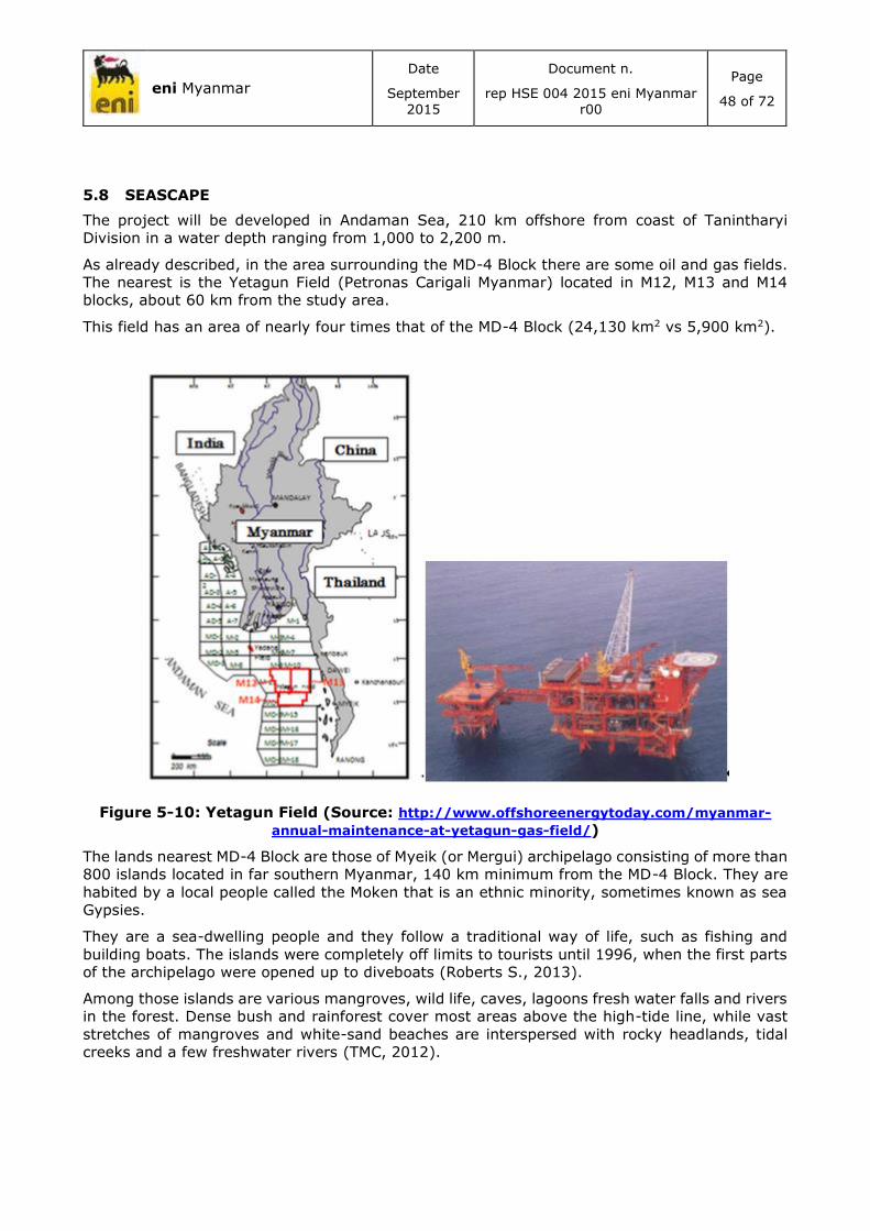
eni Myanmar
Date
September 2015
Document n.
rep HSE 004 2015 eni Myanmar r00
Page
48 of 72
5.8 SEASCAPE
The project will be developed in Andaman Sea, 210 km offshore from coast of Tanintharyi
Division in a water depth ranging from 1,000 to 2,200 m.
As already described, in the area surrounding the MD-4 Block there are some oil and gas fields.
The nearest is the Yetagun Field (Petronas Carigali Myanmar) located in M12, M13 and M14
blocks, about 60 km from the study area.
This field has an area of nearly four times that of the MD-4 Block (24,130 km2 vs 5,900 km2).
Figure 5-10: Yetagun Field (Source: http://www.offshoreenergytoday.com/myanmar-
annual-maintenance-at-yetagun-gas-field/)
The lands nearest MD-4 Block are those of Myeik (or Mergui) archipelago consisting of more than
800 islands located in far southern Myanmar, 140 km minimum from the MD-4 Block. They are
habited by a local people called the Moken that is an ethnic minority, sometimes known as sea
Gypsies.
They are a sea-dwelling people and they follow a traditional way of life, such as fishing and
building boats. The islands were completely off limits to tourists until 1996, when the first parts
of the archipelago were opened up to diveboats (Roberts S., 2013).
Among those islands are various mangroves, wild life, caves, lagoons fresh water falls and rivers
in the forest. Dense bush and rainforest cover most areas above the high-tide line, while vast
stretches of mangroves and white-sand beaches are interspersed with rocky headlands, tidal
creeks and a few freshwater rivers (TMC, 2012).

eni Myanmar
Date
September 2015
Document n.
rep HSE 004 2015 eni Myanmar r00
Page
49 of 72
Figure 5-11: Myeik (or Mergui) archipelago (TMC, 2012)
Coral Reefs are present in the offshore island of Myeik Archipalago from Tanintharyi coastal areas
(UNEP-WCMC, WorldFish Centre, WRI, TNC, 2010).
Figure 5-12: Coral Reef distribution map (UNEP-WCMC, WorldFish Centre, WRI, TNC,
2010)
Most northern, the coastline of Tanintharyi Division is characterized by:
Mouth of the Tevoy (or Dawei) River (see photos “a” and “b” in the following figure);
Some small ports and fishing villages (see photos “c” and “d” in the following figure);

eni Myanmar
Date
September 2015
Document n.
rep HSE 004 2015 eni Myanmar r00
Page
50 of 72
Some beaches and wilderness areas (see photos “e” and “f” in the following figure); and
Mangrove forests (Giri C, 2011) (see figure “g” and foto”h”);
Green areas (woods/forests).

eni Myanmar
Date
September 2015
Document n.
rep HSE 004 2015 eni Myanmar r00
Page
51 of 72
Figure 5-13: Characteristics of coastline (Source: Google Earth)
In the Taninthryi coastal areas there are also some protected areas as described in paragraph
5.7.1:
Marine Protected Areas: Lampi Island (Marine National Park), Moscos Island (Wildlife Sanctuary),
and Ross Island (Shark Protected Area).

eni Myanmar
Date
September 2015
Document n.
rep HSE 004 2015 eni Myanmar r00
Page
52 of 72
Figure 5-14: Protected areas
High Priority KBAs: Moscos Kyun W.S (Number KBAs: 102), Myeik Archipelago (Number KBAs:
105), and Lampi Island Marine N.P. (Number KBAs: 32).
Figure 5-15: High Priority KBAs
The fishery and agriculture sector are also important in the Tanintharyi Region (UNHCR, 2014).
In fact, subsistence agriculture - both permanent and shifting - is the primary livelihood in the
predominantly rural region, although the mountainous terrain limits cultivation in northern

eni Myanmar
Date
September 2015
Document n.
rep HSE 004 2015 eni Myanmar r00
Page
53 of 72
townships. Fishing is also an especially significant industry owing to the long coastline along the
Andaman Sea.
5.9 DEMOGRAPHIC FACTORS AND SOCIAL DETERMINANTS
5.9.1 Societal structure
According to the provisional results of the 2014 census, there are approximately 51.4 million
Burmese, comprising 24.8 million males and 26.6 million females.
The population in the various regions is shown in Table 5-3. There are a total of 10.9 million
households in Myanmar (MIP, 2014).
Table 5-3: Myanmar population by sex and region (MIP, 2014)
Nearly 30% of the population live in urban areas. Yangon and Kachin regions have the highest
proportions of urban dwellers at 70.1% and 35.9% respectively. In contrast, Magway and
Ayeyarwady regions have the lowest levels of urbanisation at 15.1% and 14.1% respectively
(Figure 5-16).

eni Myanmar
Date
September 2015
Document n.
rep HSE 004 2015 eni Myanmar r00
Page
54 of 72
Figure 5-16: Percentage of population living in urban areas in the different
states/region (MIP, 2014)
Yangon (14.3% of total population), Ayeyarwady (12%) and Mandalay (12%) Regions are
Myanmar’s most populated regions.
In terms of population density, the national average is 76 persons per square kilometre in
Myanmar. The highest densely populated areas are Yangon (723 persons per square kilometre),
Mandalay (206 persons per square kilometre) and Ayeyarwady (176 persons per square
kilometre).
The least densely population regions are Chin (13 persons per square kilometre), Kachin (16
persons per square kilometre) and Kayah (24 persons per square kilometre), they also have the
highest number of occupants per household (Chin and Kachin - 5.1 and Kayah - 4.8 persons in
each household). The lowest numbers of occupants per household were detected in Ayeyarwady,
Bago, Magway and Nay Pyi Taw, each at 4.1 (MIP, 2014).
The population density and household sizes for Myanmar are presented in the following figures.

eni Myanmar
Date
September 2015
Document n.
rep HSE 004 2015 eni Myanmar r00
Page
55 of 72
Figure 5-17: Percentage of population by state/region (MIP, 2014)
Figure 5-18: List of states/regions with population per square kilometre indicated
(MIP, 2014)

eni Myanmar
Date
September 2015
Document n.
rep HSE 004 2015 eni Myanmar r00
Page
56 of 72
Figure 5-19: Household sizes by state/region in Myanmar (MIP, 2014)
5.9.2 Social relationships and the local power structure
The language is age-oriented and the use of honorifics such as U (uncle) or Daw (aunt) is used
before a personal name for older men and women respectively. For young males and females
the terms Maung/Ko and Ma, respectively, may be used (Daw Mi Mi Khaing, 1958).
The elderly are spoken to with respect and there are special terms used to address monks
(Shway Yoe, 1882).
5.10 WELFARE
5.10.1 Educational system
The educational system is governed by the Ministry of Education with higher education also
supported by other ministries.
The system is modelled after the British educational system. Education in Myanmar can be
categorised into early childhood care and education or pre-primary education, basic education
and higher education.
5.10.1.1 Pre-primary education
Early childhood care and education is referred to as caring for the social, mental, physical and
spiritual needs of children under 5 years old. It includes pre-school programmes for children
between 3 to 5 years old and daycare programmes for children under 3 years old. The
programmes include centre-, community-, home- and family-based “mother circles” and
parenting education. Attendance is not mandatory.
Pre-primary education is administered by both the government and private organizations under
the supervision of the Ministry of Social Welfare, Relief and Resettlement. From 2004 to 2006,
there were increases in the number of schools as well as children enrolled. This is shown in Table
5-4; Yangon, Ayeyarwady, Bago and Mandalay divisions have the highest numbers of pre-
primary schools (IBE-UNESCO, 2011)

eni Myanmar
Date
September 2015
Document n.
rep HSE 004 2015 eni Myanmar r00
Page
57 of 72
Table 5-4: Trend in pre-school attendance in public and private institutions (IBE-
UNESCO, 2011)
Year Nr. of publicly run
schools
Nr. of privately run
schools Nr. of attendees
2004 967 3,483 142,438
2006 1,876 5,652 256,357 (49.6% female)
5.10.1.2 Primary education
Primary education is the first part of basic education and lasts for five years. It is officially
compulsory. Entry age is five years and above, starting with kindergarten or grade 1. Primary
education is divided into a lower primary cycle (grades 1 to 3) and upper primary cycle (grades
4 and 5). Many children admitted are over 6 years old. At the end of primary school, there is an
entry examination to the next level (IBE-UNESCO, 2011).
Primary schools are mainly government-run with a few exceptions in the form of international
schools that normally cater for expatriate and high-income families.
In remote areas, primary schools can take community forms. A branch school, for instance, is a
part of a main school but situated at a separate location so as to be accessibly to those who live
far away from the main school. Affiliated schools are connected to nearby public schools, through
which their pupils sit examinations. Self-help schools are autonomously established and operated
by communities but often do not cover the full primary cycle. Usually not recognized by the MOE,
these are typically located in the most remote areas (IBE-UNESCO, 2011).
Monastic schools play an important role in terms of access to education, especially for children
from poor families and children without primary caregivers. In 2005/06 monasteries ran 1,291
primary and middle schools registered with the Department of Religious Affairs, with a total of
184,749 students. Monastic schools offer free education, sometimes with boarding facilities.
They have proven excellent providers of local language instruction. Monastic schools that follow
the official primary curriculum under the supervision of the Ministry of Religious Affairs cater to
children in townships where access to public primary schools is difficult (IBE-UNESCO, 2011).
5.10.1.3 Secondary education
This is the second part of basic education and not compulsory. Secondary education is divided
into lower secondary cycle or middle school (grades 6 to 9) and upper secondary or high school
(grades 10 and 11). At the end of middle school, pupils take the Basic Education Middle School
Examination. Basic education ends with a final examination, the Basic Education High School
Examination.
Technical and vocational education is offered in agricultural institutes, high schools, technical
high schools, vocational schools and trade schools (IBE-UNESCO, 2011).
5.10.1.4 Higher education
Only students who have completed basic education and passed entry examinations are eligible
to study at university and tertiary level. Tertiary institutions include universities, colleges and
technical institutes under the administration of several ministries but mainly the Ministry of
Education, Ministry for Health and Ministry of Science and Technology.
High school leavers can undertake two-year courses in technical institutes to receive an associate
degree, called the Associateship of Government Technical Institute (AGTI).

eni Myanmar
Date
September 2015
Document n.
rep HSE 004 2015 eni Myanmar r00
Page
58 of 72
Technological colleges and universities also offer two-year courses resulting in the AGTI and
four-year and five-year programmes leading to the Bachelor of Technology and the Bachelor of
Engineering respectively.
At the university level, most bachelor’s degree courses take three years to complete, but four in
the case of law, and six years in the case of the Bachelor of Medicine and Surgery. A bachelor’s
honours degree can be achieved after an additional year of study. A postgraduate diploma
requires one or two additional years to complete, while programmes leading to the master’s
degree usually last two years. Doctoral programmes require at least four years of study and
research. All tertiary institutions are administered and financed by the government (IBE-
UNESCO, 2011; MOE, 2007).
There are 163 tertiary institutions in Myanmar. Of these, 66 institutions are under the jurisdiction
of the Ministry of Education while 97 institutions fall under 12 other ministries. They specialize
in varied fields such as arts and science, law, economics and business education, teacher
training, foreign languages, engineering, computer studies, maritime studies, defence,
agriculture, forestry, medicine, nursing, veterinary science, and culture and fine arts.
Table 5-5: Ministries and the number of associated tertiary educational institutions
(MOE, 2007)
Ministry Number of institutions
Education 66
Health 15
Science and Technology 61
Defence 5
Culture 2
Environmental Conservation and Forestry 1
Agriculture and Irrigation 1
Livestock Breeding & Fisheries 1
Co-operatives 5
Union Civil Services Board 1
Religious Affairs 1
Border Affairs 2
Transport 2
Total 163

eni Myanmar
Date
September 2015
Document n.
rep HSE 004 2015 eni Myanmar r00
Page
59 of 72
5.11 FACILITIES
5.11.1 Social infrastructure (transport, roads, electricity, water and communications)
Transport (including roads, ports, railways and airport) and energy are owned, regulated and
managed by the government. While most communication systems are state-owned, some are
also public-private ventures.
Roads
Roads are operated by the Road Transport Agency, a state-owned company.
Myanmar has approximately 142,395 km of road network. This includes national highways
(18,740 km), township network roads (19,045 km), major city roads and other roads
(26,427 km) and village and boundary area roads (78,183 km) (MIC - DICA, 2014).
There 2.33 million registered vehicles including 1.93 million motorcycles, 295,000 cars, 67,200
trucks and 20,000 buses (KPMG, 2013).
Ports
Ports are managed by the state-owned enterprises Inland Water Transport, Myanma Five Star
Line and Myanma Shipyards. Ports are located along the coastlines of the Andaman Sea in the
south and the Bay of Bengal in the southwest.
Figure 5-20: International ports in Myanmar (KPMG, 2013)

eni Myanmar
Date
September 2015
Document n.
rep HSE 004 2015 eni Myanmar r00
Page
60 of 72
Railways
Railway lines are governed by the Ministry of Rail Transportation, which operates a monopoly
managed by the government-owned Myanma Railways. The railway network comprises 5,844
km of track (KPMG, 2013).
Airports
Myanmar has 69 airports, of which only 32 are functional. There are 3 international airports in
Yangon, Mandalay and Nay Pyi Taw. There are 19 international airlines and 4 domestic airlines
covering flights between Myanmar and 17 regional destinations (KPMG, 2013).
Airports close to MD-4 Block include Dawei Airport and Myeik Airport (both in Tanintharyi Region)
and Coco Islands Airport (Yangon Region) (World Aero Data, 2015).
Energy
The energy sector is administered by:
Ministry of Energy (MOE), Energy Planning Department - exploration and production of
crude oil and natural gas, refining, manufacturing of petrochemicals and transportation,
and distribution of petroleum products;
Ministry of Electric Power (MOEP) – gas and hydropower sector, power distribution;
Ministry of Mines (MOM) – for coal;
Ministry of Agriculture and Irrigation (MOAI) – for biofuels;
Ministry of Science and Technology (MOST) – for renewable energy;
Ministry of Environmental Conservation and Forestry (MOECAF) –wood for fuel, climate
change, environmental safeguarding requirements; and
Ministry of Industry (MOI) - energy efficiency.
Energy is provided by Myanma Oil and Gas Enterprise, Myanma Petrochemical Enterprise and
Myanma Petroleum Products Enterprise. Myanmar generated 5,052 GWh (68.8%) of hydro-
electricity and 2,292 GWh (31.2%) conventional thermal energy.
Electricity
It is estimated that only a quarter of Myanmar's population currently have access to a regular
supply of electricity. Hydropower is the main source of fuel in the country and electricity from
hydropower plants comprises nearly 70% of the total electricity generated in the country,
followed by 22% produced from natural gas and 8% from coal.
Myanmar’s average electrification grew from 16% in 2006 to 26% in 2011. Big cities are
relatively well electrified: 67% for Yangon, 54% for Nay Pyi Taw and 31% for Mandalay, while
rural areas remain poorly electrified with an electrification levelofapproximately16%. Out of
62,218 villages, 2,765 villages are powered by the electrical gridand14,195 villages generate
electricity on a "self help basis" (such as biomass, solar, wind, diesel, minihydro, and biogas)
(KPMG, 2013).
Telecommunications
The telecommunications sector is regulated by the Posts and Telecommunications Department
(PFT) and Ministry of Communications and Information Technology (MCIT). It is operated and
monopolised by the state-owned Myanmar Posts and Telecommunications (MPT) (KPMG, 2013).
The sector is underdeveloped, serving only 5.4 million people in 2012. There were only 110,000
internet subscribers in 2009 (CIA, 2014).

eni Myanmar
Date
September 2015
Document n.
rep HSE 004 2015 eni Myanmar r00
Page
61 of 72
5.12 ECONOMY
5.12.1 Main economic sectors and sensitive issues
Myanmar is one of the poorest countries in South East Asia. In 2013/14, its GDP was estimated
to be US$56.8 billion. Taking into account the provisional census in 2014, this corresponds to
approximately US$1,105 per capita income (World Bank, 2014). The World Bank estimated that
the poverty rate was 37.5% of the population in 2009/10, with many more households barely
above the poverty line. Since the change in government in 2011, the government has embarked
on a “triple transition” - from a military system to democratic governance; from a centrally-
directed, closed economy to a market-oriented one; and from 60 years of conflict to peace in
the border areas. It is expected that these transformations will ensure economic progress in
Myanmar (World Bank, 2014).
5.12.2 Main economic sectors
The main economic sectors can be classified into agriculture, industry and services (CIA, 2014).
Agriculture accounted for 37% of GDP in 2010, a descent from 61% of GDP in 1986 (World Bank,
2014).Myanmar’s major agricultural products are rice, pulses, beans, sesame, groundnuts,
sugarcane, maize, rubber, fruits and vegetables, fish and fish products, and hardwood (CIA,
2014; MIC - DICA, 2014).
The fishery sector is considered to be the most important in the agriculture sector for meeting
the protein requirements of the people of Myanmar as well as for providing opportunities for
employment. The livestock and fisheries sector contributed to 7.2% of GDP in 1990-91, 7.9% in
1999-2000, 9.1% in 2005-2006 and 7.5% in 2008-2009. Total fishery product exports amounted
to roughly 9% of the total fisheries production in 2010 (FAO, 2010).
Despite agriculture being the major contributor to GDP, contributions from the industry sector
are rapidly rising particularly due to the export of gas as a natural resource. In 2010, the industry
accounted for 26% of the GDP, a rise from 10% in 1986 (World Bank, 2014).
Commodities from the industry sector include agricultural processing; wood and wood products;
copper, tin, tungsten, iron; cement and construction materials; pharmaceuticals; fertilizer; oil
and natural gas; garments; jade and gems (CIA, 2014).
The services industry includes government activities, communications, transportation, finance,
and all other private economic activities that do not produce material goods (CIA). Services
accounted for 36% of GDP in 2010, an increase from below 10% of GDP in 1986 (World Bank,
2014).
Myanmar’s international tourism income grew from $165 million in 2008 to an estimated $534
million in 2012. However, the actual figure for 2012is likely to be significantly higher (MOHT,
2013). For example, WTTC estimates that travel and tourism contributed $771 million to GDP in
2012 (WTTC, 2013).
5.13 NATIONAL HEALTH ACCOUNTS
5.13.1 Health expenditure
5.13.1.1 Background
Health financing in Myanmar comes from the state, social security system, community
contributions and foreign aid. Between 2000 and 2011/12, government spending increased from
US$ 3 to US$ 20 per capita. Despite being relatively low, government spending on health as a
percentage of GDP increased from 0.2% in 2010/11 to 0.76% in 2012/13 (MOH, Ministry of
Health, 2013). Likewise, public spending on health as a percentage of total public spending
increased from 1% 2010/11 to 3.1% in 2012/13 (MOH, 2014a). In 2011, Myanmar had the
lowest government spending on health per person in the world at only US$ 3 US (World Health
Organization, 2014c). Public expenditure for health in 2012 in the different regions/states is
shown in the following figure (MOH, Ministry of Health, 2013).

eni Myanmar
Date
September 2015
Document n.
rep HSE 004 2015 eni Myanmar r00
Page
62 of 72
Figure 5-21: Public recurrent and capital costs by regions and states (MoH, Ministry
of Health, 2014b)
Public health expenditure as a proportion of total health expenditure (i.e., public and private
expenditure) increased from 15.6% in 2010 to 23.9% in 2012.
With regard to private expenditure for health, the proportion of out-of-pocket spending increased
from 90.7% in 2010 to 93.7%
in2012(http://data.worldbank.org/indicator/SH.XPD.PUBL/countries).
5.14 HEALTH CARE DELIVERY SERVICES
5.14.1 Health sector
5.14.1.1 Public
The Department of Health, the largest department of the Ministry of Health, employs 93% of
over 58,000 personnel that work for the Ministry, and accounts for approximately 75% of the
Ministry’s expenditure. It is responsible for supervising both technical and administrative
functions of the health departments in the regions and township levels as well as hospitals and
clinics. The unit of operation of health is at the Township Health Department level; each Township
Health Department serves between 100,000 and 200,000 people, and is headed by the Township
Medical Office. At township level, a hospital and clinics take care of curative functions, while the
public health component is the responsibility of the health department. The Urban Health Centre,
School Health Team, and Maternal and Child Health Centre take care of the urban population.
Each township has at least 1-2 station hospitals and 4-7 Rural Health Centres (RHC) under its
jurisdiction to provide health services to the rural population. RHCs are staffed by a Health
Assistant (HA), Lady Health Visitor (LHV), and a midwife. At each RHC there are four to five sub-
centres, each of which are staffed with a midwife and a Public Health Supervisor. Each sub-
health centre provides healthcare services to a cluster of five to ten villages, in which there are
usually voluntary health workers (auxiliary midwives and community health workers) (WHO,
2014b).
5.14.1.2 Private
This sector is expanding, particularly in cities and towns, although recently it has been reported
that there are village-level general practices in some locations. In 2010, there were 103 private
hospitals, 192 special clinics and 2,891 general clinics. Private sector health care is estimated to

eni Myanmar
Date
September 2015
Document n.
rep HSE 004 2015 eni Myanmar r00
Page
63 of 72
provide 75–80% of ambulatory care. It is estimated that 61% of medical doctors in 2010 are
employed in the private sector (WHO, 2014b).
Volunteers and members of local NGOs and faith-based organizations are also active in the field
of health. For example, the Myanmar Maternal and Child Welfare Association (MMCWA) and
Myanmar Red Cross Society (MRCS) have members working in several villages. Religious
societies also provide ambulatory care though some provision of institutional care (WHO,
2014b).
There are also a number of private traditional practitioners who are licensed and regulated (MOH,
Ministry of Health, 2013).
5.14.2 Health referral system
There are General Hospitals, Specialist Hospitals, Teaching Hospitals, region/state Hospitals,
District Hospitals, Township Hospitals in urban areas. Sub-township Hospitals, Station Hospitals,
Rural Health Centres and Sub-Rural Health Centres provide comprehensive health care services
for the rural population (MOH, Ministry of Health, 2013).
5.14.2.1 Primary care
Rural and Sub-Rural Health Centres provide initial access to the health system (MOH, Ministry
of Health, 2013).
5.14.2.2 Secondary care
Station Hospitals, including Sub-township Hospitals, comprise the first referral level. These
hospitals provide general medical services and general surgical services. Services provided at
Township Hospitals include laboratory services and dental services (MOH, Ministry of Health,
2013).
Specialist services can be easily accessed at District and some 50 bedded Township Hospitals,
where intensive care units with life-saving facilities are available (MOH, Ministry of Health, 2013).
5.14.2.3 Tertiary care
Tertiary health care services are provided at the region /state Level, Central and Teaching
Hospitals.
5.14.3 Human resources for health
In 2014, there were 104,227 health professionals including 31,542 medical practitioners,
26,928 nurses and 20,044 midwives (MoH, Ministry of Health, 2014b).

eni Myanmar
Date
September 2015
Document n.
rep HSE 004 2015 eni Myanmar r00
Page
64 of 72
Table 5-6: Health professionals in Myanmar from 1988 to 2011. (MoH, Ministry of
Health, 2014b)
5.14.4 Health financing outlines: mechanisms of funding health care
According to the National Health Accounts data (2008 and 2009), health expenditures by
financing agents are as follows: Ministry of Health (10%), other Ministries (0.8% to 0.9%), social
security board (0.15%), private household out-of-pocket expenses (82% to 85%) and not-for-
profit organisations serving households (4% to 6%) (MoH, Ministry of Health, 2012b).
5.14.5 Health infrastructures and medical equipment
Between 2013 and 2014, there were 1056 public hospitals in Myanmar, an increase from 631
hospitals between 1988 and 1989. The number of hospital beds more than doubled within the
same period from 25,309 to 56,748 beds. There were fewer secondary and primary health
centres. Between 1988 and 2014, there has been an increase of secondary and primary health
facilities from 64 to 87. There are also currently 16 traditional hospitals, up from only 2 such
institutions in 1988-89. In 2013-14, there were 243 traditional clinics. Health facilities in
Myanmar are presented in the table below.

eni Myanmar
Date
September 2015
Document n.
rep HSE 004 2015 eni Myanmar r00
Page
65 of 72
Table 5-7: Health facilities in Myanmar from 1988 to 2014. (MoH, Ministry of Health,
2014b)

eni Myanmar
Date
September 2015
Document n.
rep HSE 004 2015 eni Myanmar r00
Page
66 of 72
6 ENVIRONMENTAL IMPACTS ASSESSMENT AND MITIGATION MEASURES
The key components described in the previous paragraphs have been analysed in order to
identify any potential project-related environmental, socio-economic and health impacts and to
identify the mitigation measures and procedures that eni will adopt to reduce them.
An impact is any change, or perceived change, whether adverse or beneficial, wholly or partially
resulting from eni’s activities, products or services (as defined in ISO 14001:2004).
The aim of the project is the re-processing of the legacy 2D seismic data, consisting of only office
analysis of existing data with specific software.
Regarding the activities object of the present IEE no environmental/social/health impacts have
been identified.
Currently the seismic survey is not object of the present study, if in the future eni will proceed
to first exploration period a further IEE will be developed in order to identify potential impacts
and appropriate mitigation measures related to seismic survey activities.

eni Myanmar
Date
September 2015
Document n.
rep HSE 004 2015 eni Myanmar r00
Page
67 of 72
7 CONCLUSIONS
The present Initial Environmental Examination study has been conducted for MD-4 Block area.
The aim of the project is the re-processing of the legacy 2D seismic data, consisting of only office
analysis of existing data with specific software.
Regarding the activities object of the present IEE no environmental/social/health impacts have
been identified.
Currently the seismic survey is not object of the present study, if in the future eni will proceed
to first exploration period will be developed a further IEE for the activities.

eni Myanmar
Date
September 2015
Document n.
rep HSE 004 2015 eni Myanmar r00
Page
68 of 72
REFERENCES
(s.d.). Tratto da http://www.myanmarburma.com/.
Afsal et Al. (2008). A note on cetacean distribution in the Indian EEZ and contiguous seas during
2003-07. J. CETACEAN RES. MANAGE. 10(3), p. 209–215.
AIT/UNEP, R. R. (2010). MUNICIPAL WASTE MANAGEMENT REPORT: Status-quo and Issues in
Southeast and East Asian Countries.
AIU. (2014). Industrial Globalization for Myanmar - A final thesis presented to the academic
department of the school of science and engineering in partial fulfilment of the
requirements for the degree of doctor of philosophy (Industrial Engineering). Honolulu,
Hawaii - March 12, 2014: Atlantic International University.
AIU, A. I. (2014). Industrial Globalization for Myanmar - A final thesis presented to the academic
department of the school of science and engineering in partial fulfilment of the
requirements for the degree of doctor of philosophy (Industrial Engineering). Honolulu,
Hawaii - March 12, 2014.
André M. et Al. (2009). Best practices in management, assessment and control of underwater
noise pollution . Laboratory of Applied Bioacoustics, Technical University of Catalonia,
CONAT150113NS2008029.
API, A. P. (2009). Compendium Of Greenhouse Gas Emissions Methodologies For The Oil And
Natural Gas Industry.
APPEA, A. P. (2013). SEISMIC AND THE MARINE ENVIRONMENT. http://www.appea.com.au/wp-
content/uploads/2013/05/Seismic_and_the_Marine_Environment.pdf.
Arveson P. T., a. V. (2000). 2000. Radiated noise characteristics of a modern cargo ship. Journal
of the Acoustical Society of America, Vol. 107, 118-129.
Aung Min Han, M. I. (2013). Logistics Infrastructure and Supply Chain System In Myanmar.
Bahroo, L. B. (2003, May-June 2003). Myanmar: Intersecting Destinies of a New Asia. BHARAT
RAKSHAK MONITOR - Volume 5(6) .
Bertrand et Al. (1998). The Singu basalts of Myanmar: new constraints for the amount of recent
offset on the Sagaing Fault.
BOBLME. (2011). Marine Turtle Conservation: Review Report. BOBLME-2011-Ecology-18. Bay of
Bengal Large Marine Ecosystem Project.
BOBLME. (2015). Tratto da http://boblme.reefbase.org/mapgallery.aspx
BOBLME, (. o. (2011). Marine Turtle Conservation: Review Report. BOBLME-2011-Ecology-18.
Boeger W.A. et Al. (2006). The effect of exposure to seismic prospecting on coral reef fishes.
Brazilian Journal of Oceanography 54, 235-239.
BOEM, B. o. (2014). Atlantic OCS Proposed Geological and Geophysical Activities, Mid-Atlantic
and South Atlantic Planning Areas - Final Programmatic Environmental Impact
Statement_ Volume III: Appendices B-M. Stuart, Florida 34997: U.S. Department of the
Interior - http://www.boem.gov/BOEM-2014-001-v3/.
Casper B.M. et Al. (2012). Are sharks even bothered by a noisy environment? New York: A. N.
Popper and A.D. Hawkins, editors.
CIA, C. I. (2014). Tratto da https://www.cia.gov/library/publications/the-world-
factbook/geos/bm.html
Continental Shelf Associates Inc. (2004). Geological and Geophysical Exploration for Mineral
Resources on the Gulf of Mexico Outer Continental Shelf - Final Programmatic

eni Myanmar
Date
September 2015
Document n.
rep HSE 004 2015 eni Myanmar r00
Page
69 of 72
Environmental Assessment. New Orleans: U.S. Department of the Interior - Minerals
Management Service - Gulf of Mexico OCS Region.
Daw Mi Mi Khaing. (1958). Burmese Names: A guide. The Atlantic.
Department of Hydrology and Meteorology of Myanmar et Al. (2009). Hazard Profile of Myanmar.
DOSITS, D. o. (2015). http://www.dosits.org/.
Driel W.F. van & T.A. Nauta. (2013). Vulnerability and Resilience Assessment of the Ayeyarwady
Delta in Myanmar, Scoping phase. Available at: www.delta-alliance.org: Bay of Bengal
Large Marine Ecosyste (BOBLME) Project, Global Water Partnership (GWP) and Delta
Alliance, Delft-Wageningen The Netherlands.
EEA, E. E. (2013). EMEP/EEA air pollutant emission inventory - guidebook 2013. Technical
guidance to prepare national emission inventories. EEA Technical report No 12/2013 :
Luxembourg: Publications Office of the European Union, 2013 ISSN 1725-2237.
eni. (2013). Minimum HSE Requirements in Geophysical Operations. opi sg hse 002 e&p r01 .
FAO. (2010). Fishery and Aquaculture Country Profiles. Myanmar.
GEBCO. (2014). GEBCO. Tratto da The GEBCO_2014 SID Grid, version 20141103,
http://www.gebco.net: http://www.bodc.ac.uk/products/bodc_products/gebco/
Giri C, O. E. (2011). tatus and distribution of mangrove forests of the world using earth
observation satellite data. Global Ecology and Biogeography 20: 154-159 ;
http://data.unep-wcmc.org/datasets/4.
Giri C, Ochieng E, Tieszen LL, Zhu Z, Singh A, Loveland T, Masek J, Duke N. (2011). tatus and
distribution of mangrove forests of the world using earth observation satellite data. Global
Ecology and Biogeography 20: 154-159 ; http://data.unep-wcmc.org/datasets/4.
GMS Agriculture. (2013, Updated on: 20 October 2013). Greater Mekong Subregion Atlas of the
Environment (2nd Edition) - Overview map of GMS Agriculture. Tratto da Download at
www.gms-eoc.org.
Gordon J. et Al. (2004). A Review of the Effects of Seismic Surveys on Marine Mammals. Marine
Technology Society Journal - Winter 2003/04 Volume 37, Number 4.
Hildebrand J.A. (2009). Anthropogenic and natural sources of ambient noise in the ocean. . Mar.
Ecol. Prog. Ser 395, 4-20.
Holst M. et Al. (2007). Effects of Large and Small-Source Seismic Surveys on Marine Mammals
and Sea Turtles. American Geophysical Union, Fall Meeting, Internet website:
http://adsabs.harvard.edu/abs/2006AGUSMOS42A..01H.
IAGC, I. A. (2011a). Recommended Mitigation Measures for Cetaceans during Geophysical
Operations, June 2011. Available at: www.iagc.org/files/2682/ .
IAGC, I. A. (2011b). Guidance for Marine Life Visual Observers. Available at:
www.iagc.org/files/2951/.
IBE-UNESCO. (2011). World Data on Education 2010/2011. International Bureau of Education
and United Nations Educational, Scientific and Cultural Organisation.
IFC PS6, (. F. (2012). Performance Standard 6 - Biodiversity Conservation and Sustainable
Management of Living Natural Resources.
IFC, (. F. (2007). Environmental, Health, and Safety (HSE) General Guidelines.
IPIECA and OGP. (2011). Ecosystem services guidance - Biodiversity and ecosystem services
guide and checklists. Available at: http://www.ipieca.org/library .
IUCN, A. J. (2008). Hawksbill Turtle (Eretmochelys imbricate). Marine Turtle Specialist Group
2008 IUCN Red List status.

eni Myanmar
Date
September 2015
Document n.
rep HSE 004 2015 eni Myanmar r00
Page
70 of 72
JNCC, J. N. (2010). JNCC guidelines for minimising the risk of injury and disturbance to marine
mammals from seismic surveys.
KetosEcology. (2009). 'TURTLE GUARDS': A METHOD TO REDUCE THE MARINE TURTLE
MORTALITY OCCURRING IN CERTAIN SEISMIC SURVEY EQUIPMENT.
http://www.ketosecology.co.uk/PDF/KE2009_Turtle_guards.pdf.
KPMG. (2013). Infrastructure in Myanmar.
Kyaw Naing. (2011). Country report on pollution-Myanmar.
Lusseau D. (2005). Residency pattern of bottlenose dolphins Tursiops spp. In Milford Sound,
New Zealand, is related to boat traffic. Mar. Ecol. Prog. Ser. 295, 265–272.
McCauley R.D. et Al. (2000). MARINE SEISMIC SURVEYS - STUDY OF ENVIRONMENTAL
IMPLICATIONS. APPEA JOURNAL, 692-708.
McCauley R.D. et Al. (2003). High intensity anthropogenic sound damages fish ears. J. Acoust.
Soc. Am., Vol. 113, No. 1, 638-642.
MIC - DICA. (2014). Myanmar Investment Guide 2014.
MIP, M. o. (2014). The population and housing census of Myanmar 2012: Summary of the
provisional results.
MOE, (. o. (2007). Mid-decade Assessment Report. Yangon.
Moein S.E. et Al. (1995). Evaluation of seismic sources for repelling sea turtles from hopper
dredges. Sea Turtle Research Program: Summary Report - Technical Report CERC-95,
90-93.
MOH, M. o. (2014a). Health in Myanmar 2014. Nay Pyi Taw.
MoH, Ministry of Health. (2012b). Health in Myanmar 2012. Nay Pyi Taw.
MOH, Ministry of Health. (2013). Health in Myanmar 2013. Nay Pyi Taw.
MOH, Ministry of Health. (2013). Health in Myanmar 2013. Nay Pyi Taw.
MoH, Ministry of Health. (2014b). Public Health Statistics Report 2012. Nay Pyi Taw.
MOHT, M. o. (2013). Tourism Master Plan 2013-2020.
MRC, M. R. (2013). Waste Management Guidelines Prepared for Chiang Saen Commercial Port
Area.
Myint Pe. (no date). NATIONAL REPORT OF MYANMAR On the Sustainable Management of The
Bay of Bengal Large Marine Ecosystem (BOBLME). GCP/RAS/179/WBG.
Myint, U. L. (2015). Deepwater Petroleum Geology Rakhine Offshore Basin, Myanmar. 2nd
Myanmar Oil & Gas Exhibition and Conference, 18 - 21 May 2015. Yangon.
NOAA and U.S. Fish and Wildlife Service. (2013). HAWKSBILL SEA TURTLE (ERETMOCHELYS
IMBRICATA) - 5-YEAR REVIEW: SUMMARY AND EVALUATION.
NOAA, N. O. (2010). NOAA’s Oil Spill Response - Effects of Oil on Marine Mammals and Sea
Turtles.
http://www.noaa.gov/factsheets/new%20version/marinemammals_seaturtles.pdf.
Nwe Ni Win et Al. (s.d.). Myanmar Agriculture Service, The Union Of Myanmar.
O’Hara J. & Wilcox J. R. (1990). Avoidance Responses of Loggerhead Turtles, Caretta caretta, to
Low Frequency Sound.
Ohnmar May Tin Hlaing et Al., M. K. (2014). Myanmar Country Profile: Focus on Cities.

eni Myanmar
Date
September 2015
Document n.
rep HSE 004 2015 eni Myanmar r00
Page
71 of 72
Okeanos, F. f. (2008). Underwater Radiated Noise of Ocean-Going Merchant Ships - A
Background Paper Produced by Participants of the International Workshop on Shipping
Noise and Marine Mammals. Hamburg, Germany,.
OSPAR Commission. (2009). Overview of the impacts of anthropogenic underwater sound in the
marine environment. London, UK.
PAEHolmes. (2011). POTENTIAL MEASURES FOR AIR EMISSIONS FROM NSW PORTS -
PRELIMINARY STUDY.
http://www.epa.nsw.gov.au/resources/air/PortsPreliminaryStudy.pdf.
Pidcock S. et Al. (2003). The potential sensitivity of marine mammals to mining and exploration
in the Great Australian Bight Marine Park Marine Mammal Protection Zone - An
independent review and risk assessment report to Environment Australia.
Popper A.N. and Hastings M.C. (2009). The effects of anthropogenic sources of sound on fishes.
Journal of Fish Biology 75 available online at www.interscience.wiley.com, 455–489.
Ramasamy; Rao; Thwin; Raiker. (2004). Tital influence on suspended sediment distribution and
dispersal in the northern Andaman Sea and Gulf of Martaban. 33-42.
Ramasamy; Rao; Thwin; Raiker. (2004). Tital influence on suspended sediment distribution and
dispersal in the northern Andaman Sea and Gulf of Martaban. 33-42.
Richardson W. J. et Al, G. C. (1995). Marine Mammals and Noise. San Diego CA: Academic Press.
Rizal Syamsul, P. D. (2012). GENERAL CIRCULATION IN THE MALACCA STRAIT AND ANDAMAN
SEA: A NUMERICAL MODEL STUDY. American Journal of Environmental Science, 8 (5), ,
479-488.
Roberts S. (2013). The lost world: Myanmar’s Mergui islands. Financial Times.
Shway Yoe, (. J. (1882). The Burman - His Life and Notions. New York: The Norton Library 1963.
Smith, B. D. (2007). CONSERVATION STATUS OF IRRAWADDY DOLPHINS (ORCAELLA
BREVIROSTRIS). Convention on the Conservation of Migratory Species of Wild Animals -
14th MEETING OF THE CMS SCIENTIFIC COUNCIL. Bonn, Germany, 14-17 March 2007.
SWM. (2013). European Project: “Environmental protection and sustainable development:
building local capacities on solid waste management in Myanmar” - Legal Framework
Report.
T. A. Jefferson and S. K. Hung. (2004). Neophocaena phocaenoides. MAMMALIAN SPECIES,
Published 13 July 2004 by the American Society of Mammalogists, No. 746, pp. 1–12, 3
figs.
Thant Soe and Lwin Maung Maung. (2012). Distribution of Hawksbill Turtles (Erethmochelys
imbricata) in Longlonebok Island and its Adjacent Area in Myanmar. Proceedings of the
7th International Symposium on SEASTAR2000 and Asian Bio-logging Science (The 11th
SEASTAR2000 workshop), (pp. 9-14). Kyoto University Research Information Repository.
Thorbjarnarson J.B. et Al. (2000, Avalaible at:
http://www.seaturtle.org/mtn/archives/mtn88/mtn88p10.shtml). Sea Turtles in
Myanmar: Past and Present. Marine Turtle Newsletter 88:10-11.
TMC. (2012). Hand book on Mergui tours - tours in the Mergui Archipelago. Retrieved from
http://www.merguitours.com/.
UN News Centre. (2015). Cyclone Komen further burdens thousands of displaced people in
western Myanmar – UN agencies (Available at:
http://www.un.org/apps/news/story.asp?NewsID=51559#.VgFVoPntlBc)
UNCRD, U. N. (2010). Country Presentation for 2ndMeeting of the Regional 3R Forum.
2ndMeeting of the Regional 3R Forum, (p. 39). Kuala Lumpur, Malaysia.

eni Myanmar
Date
September 2015
Document n.
rep HSE 004 2015 eni Myanmar r00
Page
72 of 72
UNEP-WCMC, WorldFish Centre, WRI, TNC. (2010). Tratto da http://data.unep-
wcmc.org/datasets/1.
UNEP-WCMC, WorldFish Centre, WRI, TNC. (2010). Global distribution of warm-water coral reefs,
compiled from multiple sources including the Millennium Coral Reef Mapping Project.
Includes contributions from IMaRS-USF and IRD (2005), IMaRS-USF (2005) and Spalding
et al. (2001). Cambridge (UK): UNEP Worl.
UNHCR, S.-E. M. (2014). TANINTHARYI REGION PROFILE.
WCS, W. C. (2013). Myanmar Biodiversity Conservation. Yangon, Myanmar.
WDCS, W. a. (2004). Oceans of Noise. Mark Simmonds, Sarah Dolman and Lindy Weilgart.
WDCS, W. a. (2006). Vessel collisions and cetaceans: What happens when they don’t miss the
boat . http://uk.whales.org/sites/default/files/whales-and-ship-strikes.pdf.
Webb E.L. at Al. (2014). Deforestation in the Ayeyarwady Delta and the conservation
implications of an internationally-engaged Myanmar. Global Environmental Change,
Volume 24, January 2014, 321-333.
Weir C.R. (2007). Observations of Marine Turtles in Relation to Seismic Airgun Sound off Angola.
Marine Turtle Newsletter 116 -
http://www.seaturtle.org/mtn/archives/mtn116/mtn116p17.shtml, 17-20.
WEPA, W. E. (2009). Outlook of Water Environmental Management Strategies in Asia. Institute
for Global Environmental Strategies (IGES).
WHO. (2014b). World Health Organization, Country Office for Myanmar - WHO country
cooperation strategy 2014-2018. Yangon, 2008.
World Aero Data. (2015). Airports in Burma.
World Bank. (2014). Myanmar, Ending poverty and boosting shared prosperity in a time of
transition. A Systematic Country Diagnostic. November, 2014. Accessed 12th January,
2015:
http://www.worldbank.org/content/dam/Worldbank/document/EAP/Myanmar/WBG_SC
D_Full_Report_English.pdf.
World Health Organization. (2014c). WHO Global Health Expenditures Atlas. Geneva, 2014.
Ministry of National Planning and Economic Development and Ministry of Health, Myanmar
(2011). Myanmar Multiple Indicator Cluster Survey 2009 - 2010 Final Report.
WRI, (. R. (2013). Weaving Ecosystem Services into Impact Assessment - A Step-by-Step
Method. Available at: http://www.wri.org/publication/weaving-ecosystem-services-into-
impact-assessment: . By Florence Landsberg, Mercedes Stickler, Norbert Henninger, Jo
Treweek and Orlando Venn - October 2013.
WTTC, W. T. (2013). Travel and Tourism Economic Impact 2013. Myanmar. London.
Zau Lunn. (2012). Status and challenges of coral reef monitoring in Myanmar. ICRI
(International Coral Reef Initiative) East Asia Regional Workshop - 8th_EARW. Jeju,
Korea: Biodiversity and Nature Conservation (BANCA) & Fauna & Flora International
(FFI).