identification of sting-jet extratropical cyclones in era-interim
DESCRIPTION
EGU General Assembly 2010 04 May 2010 Vienna, Austria. Identification of sting-jet extratropical cyclones in ERA-Interim. Oscar Martinez-Alvarado ( [email protected] ) Suzanne Gray Department of Meteorology University of Reading. Sting Jets. - PowerPoint PPT PresentationTRANSCRIPT

Identification of sting-jet extratropical cyclones in ERA-Interim
Oscar Martinez-Alvarado ([email protected])
Suzanne Gray
Department of MeteorologyUniversity of Reading
EGU General Assembly 201004 May 2010Vienna, Austria
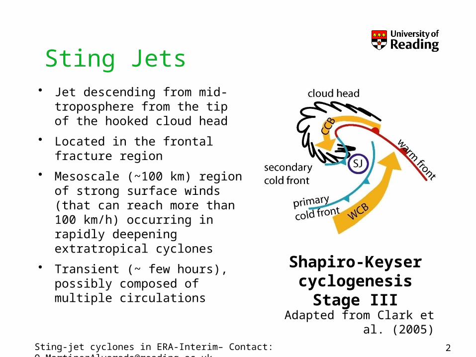
Sting Jets• Jet descending from mid-
troposphere from the tip of the hooked cloud head
• Located in the frontal fracture region
• Mesoscale (~100 km) region of strong surface winds (that can reach more than 100 km/h) occurring in rapidly deepening extratropical cyclones
• Transient (~ few hours), possibly composed of multiple circulations
Sting-jet cyclones in ERA-Interim– Contact: [email protected]
Shapiro-Keyser cyclogenesisStage III
Adapted from Clark et al. (2005)

Sting Jets• Case-studies
• Mechanisms hypothesized to be important:– Evaporative cooling of cloudy air, and – The release of conditional symmetric instability (CSI)
• Global frequency and distribution are unknown
Great Storm 15/16 October 1987
UK Browning 2004; Clark et al. 2005
Anna 25/26 February 2002
UK Martinez-Alvarado et al. 2010
Jeanette 27 October 2002 UK Parton et al. 2009Oili 07-11 February
2006UK, Germany
Weidle and Wernli 2008
Gudrun 07/08 January 2007
UK, N. Europe
Baker 2009
Sting-jet cyclones in ERA-Interim– Contact: [email protected]

• There are just a handful of well-documented case studies on sting jets (Browning 2004, Clark et al. 2005, Parton et al. 2009, Baker 2009).
• These are valuable for all the detailed insight they provide into the structure and dynamics of sting jets.
• However, they cannot answer the question of how frequently sting jets occur.
• Another unanswered question is what other regions (apart from the UK and N. Europe) are likely to experience sting jets.
The need for a climatology of sting jets
4Sting-jet cyclones in ERA-Interim– Contact: [email protected]

Unstable slantwise convective circulations in an otherwise inertially and gravitationally stable atmosphere
Downdraught SCAPE (DSCAPE) is the potential energy available to parcel to descend in slanted downdraughts
CSI and Downdraught SCAPE
qe* increasing
Mg
incr
easin
g
Sting-jet cyclones in ERA-Interim– Contact: [email protected]

Storm Anna:Synoptic situation
Synoptic situation at 0700 UTC on 26 February 2002. The bold grey line represents the edge of the cloud head. The red circle marks the position of the sting jet at each time.
Sting-jet cyclones in ERA-Interim– Contact: [email protected]

Storm Anna:Downdraught SCAPE
Downdraught SCAPE (DSCAPE, in J/kg) at (A) 0100 UTC and (B) 0300 UTC on 26 February 2002. The bold dark line represents the edge of the cloud head; the grey lines are lines of constant wet-bulb potential temperature (in K). The red circle marks the position of the sting jet at each time.
A B
Sting-jet cyclones in ERA-Interim– Contact: [email protected]

• Minimum DSCAPE descending from the mid-troposphere – DSCAPE > 200 J kg-1
• Search restricted to upper levels– pstart < 650 hPa
• Moisture needed to precipitate over unstable areas with large DSCAPE– RH > 80 %
• Location within a fractured cold front
• Threshold values appear to be robust for a number of cases
A climatology of sting jets
11 K kmwq 3 112 10 K swv q
8Sting-jet cyclones in ERA-Interim– Contact: [email protected]

• ERA-Interim is the new ECMWF reanalysis covering the period 1989-present
• Resolution: ~0.7°• This work looks at fields on pressure levels• Domain limited to 30°N - 70°N, 70°W - 30°E
(North Atlantic and Europe)• 50 most intense cyclones during the first ten
years in the reanalysis (1989-1998). Thanks to Jen Catto for kindly providing these cyclone tracks.
• Only winter months (DJF)
A climatology of sting jets
using ERA-Interim
9Sting-jet cyclones in ERA-Interim– Contact: [email protected]

10
Sting Jet Cyclones in ERA-Interim:Track 39
Mid-tropospheric CSI regions near (red circles) or far from (green circles) cyclone. Grey: wet-bulb potential temperature at 600 hPa. Blue: RH at 550 hPa.
RH at 550 hPa
qw at 600 hPa
Instability region
Sting-jet cyclones in ERA-Interim– Contact: [email protected]
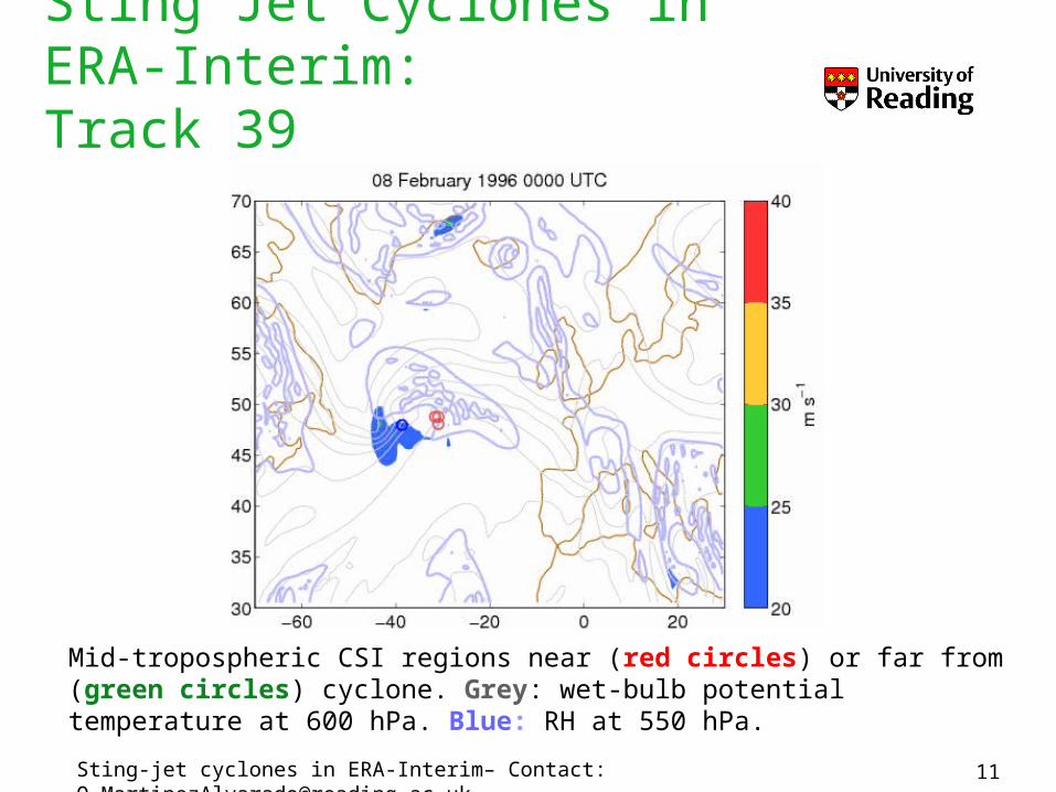
Sting Jet Cyclones in ERA-Interim:Track 39
11
Mid-tropospheric CSI regions near (red circles) or far from (green circles) cyclone. Grey: wet-bulb potential temperature at 600 hPa. Blue: RH at 550 hPa. Sting-jet cyclones in ERA-Interim– Contact: [email protected]

From the 50 most intense cyclones:• ~29 show CSI in the vicinity of the cyclone
centre• ~8 show the potential to develop sting jets.
• ~16 cyclones show instability regions associated with the warm conveyor belt
12
Sting Jet Cyclones in ERA-Interim:Preliminary results
Dec 1989 Dec 1989 Dec 1991 Jan 1992Jan 1993 Dec 1995 Feb 1996 Feb 1997
Sting-jet cyclones in ERA-Interim– Contact: [email protected]

Limitations and possible ways forward• A missing link: surface observations (how much
surface damage have sting jets actually caused?)
• The small number of cases found in these years in ERA-Interim will allow us to look into them in detail (in mesoscale simulations)
• Ongoing work is to extend the period of analysis to the full ERA-Interim period, and to the rest of the extra-tropical region.
13Sting-jet cyclones in ERA-Interim– Contact: [email protected]

Conclusions• Mid-tropospheric regions of CSI have been shown to be
very well spatially correlated with descending sting jets in mesoscale simulations of 3 sting jet storms (and are not present in a storm without a sting jet).
• A DSCAPE-based method to detect sting jet precursors has been developed and has started to give results.
• This method is being currently applied to the ECMWF reanalysis ERA-Interim.
• In the first 10 years of the dataset 8 out of 50 most intense cyclones show signs of mid-tropospheric CSI.
• The occurrence of sting jets in these cyclones is still awaiting verification.
14Sting-jet cyclones in ERA-Interim– Contact: [email protected]

Other sting-jet presentations in EGU 2010• Sting jets in severe northern European wind storms:
a case study of Windstorm GudrunLaura Baker, Suzanne Gray, and Peter ClarkNH1.7/AS4.10 Extreme events induced by extreme weather and climate change: Evaluation and forecasting of disaster risk and proactive planning Room 3 / Mon, 03 May, 9:00–09:15
• Idealised simulations of sting jet cyclonesLaura Baker, Suzanne Gray, and Peter ClarkAS1.1Dynamical Meteorology (General Session) Halls X/Y / Thu, 06 May, 08:00–19:30 XY13
15Sting-jet cyclones in ERA-Interim– Contact: [email protected]

16
References1. Baker, L., 2009: Sting jets in severe northern European wind storms.
Weather, 64 (6), 143-148.2. Browning, K. A., 2004: The sting at the end of the tail: Damaging winds
associated with extratropical cyclones. Q. J. R. Meteorol. Soc., 130, 375-399.
3. Clark, P. A., K. A. Browning and C. Wang, 2005: The sting jet at the end of the tail: Model diagnostics of fine-scale three-dimensional structure of the cloud head, Q. J. R. Meteorol. Soc., 131, 2263-2292.
4. Martinez-Alvarado, O., F. Weidle and S. L. Gray, 2010: Robust characteristics of sting jets as simulated by two mesoscale models, Re-submitted to Mon. Wea. Rev..
5. Parton, G. A., G. Vaughan, E. G. Norton, K. A. Browning and P. A. Clark, 2009: Wind profiler observations of a sting jet. Q. J. R. Meteorol. Soc., 135 (640), 663-680.
6. Schultz, D. A. and P. N. Schumacher, 1999: The use and misuse of conditional symmetric instability. Mon. Wea. Rev., 127, 2709-2732.
Sting-jet cyclones in ERA-Interim– Contact: [email protected]