ideas for flood management - meta metametameta.nl/.../2015/01/ideas_flood_management.pdf · ideas...
TRANSCRIPT
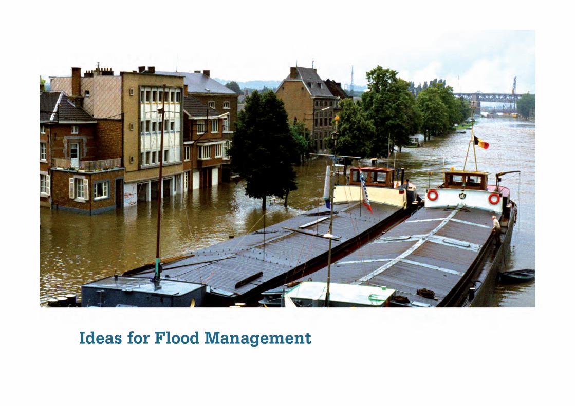
Ideas for Flood Management

Cover photo: copyright SevS/Roel Slootweg


3
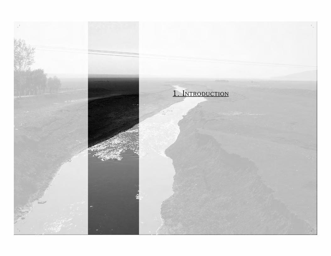
1. INTRODUCTION
2. FLOOD PREVENTION
2.1 Increasing flow capacity and diversion 14
2.2 Water retention 17
2.3 Management of catchment areas 22
2.4 Integrating drainage and flood prevention measures 23
3. FLOOD PROTECTION
3.1 Innovations in engineering 28
3.2 Integrating embankments with other measures 30
3.3 Alternative protection measures 31
3.4 Financial initiatives 34
4. PRE-FLOOD MITIGATION
4.1 Flood proofing 38
4.2 Flood preparedness 40
5. POST-FLOOD MITIGATION
5.1 Evacuation 56
5.2 Post-disaster communication 58
5.3 Emergency relief 59
5.4 Restoring livelihoods 64
6 BENEFITS OF FLOODWATERS AND FLOODPLAINS
6.1 Using floodwater for irrigation 70
6.2 Floods and fisheries 72
6.3 Using floodwaters for groundwater recharge and water buffers 73
ANNEX 1: REFERENCE SOURCES
ANNEX 2: L IST OF RESOURCES

1. INTRODUCTION

6
1.1 FLOOD RISKS ON THE INCREASE?
Floods affect more people every year than all other natu-
ral and technological disasters put together. The damage
caused by floods to people and property across the world
has been extremely severe in recent decades. Of the 367,000
people that lost their lives in natural disasters between 1986
and 1995, more than half were victims of storm surges, river
floods or flash floods. From 1998 to 2002, 683 flood disasters
have been recorded around the world, with 97% of these
floods occurring in Asia; the rest occurred mainly in Africa.
On an average, about 140 million people worldwide are af-
fected by floods every year (Douben, Ratnayake, 2005).
Europe also suffers from floods. The Elbe floods of August
2002 caused numerous casualties, rendered several people
homeless and resulted in property damages amounting to
several billion euros across many European countries. More
recently, in the summer of 2005, Bulgaria and Romania were
hit by floods from the Danube River resulting in similar de-
struction. It appears that floods are becoming increasing-
ly destructive and damaging. In China, for instance, flood
damage has increased by an estimated 500% from the 1950s
to the 1990s. As a result of human activities and climate
change, the occurrence of floods will futher increase in the
years to come.
INTRODUCTION
Global flood mortality
7
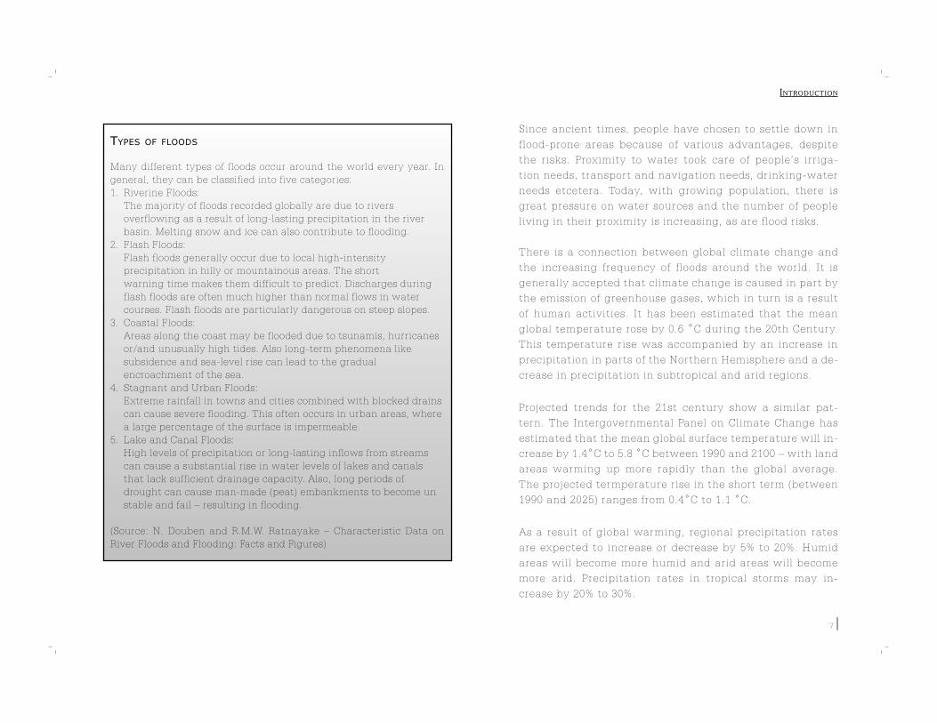
TYPES OF FLOODS
Many different types of floods occur around the world every year. In
general, they can be classified into five categories:
1. Riverine Floods:
The majority of floods recorded globally are due to rivers
overflowing as a result of long-lasting precipitation in the river
basin. Melting snow and ice can also contribute to flooding.
2. Flash Floods:
Flash floods generally occur due to local high-intensity
precipitation in hilly or mountainous areas. The short
warning time makes them difficult to predict. Discharges during
flash floods are often much higher than normal flows in water
courses. Flash floods are particularly dangerous on steep slopes.
3. Coastal Floods:
Areas along the coast may be flooded due to tsunamis, hurricanes
or/and unusually high tides. Also long-term phenomena like
subsidence and sea-level rise can lead to the gradual
encroachment of the sea.
4. Stagnant and Urban Floods:
Extreme rainfall in towns and cities combined with blocked drains
can cause severe flooding. This often occurs in urban areas, where
a large percentage of the surface is impermeable.
5. Lake and Canal Floods:
High levels of precipitation or long-lasting inflows from streams
can cause a substantial rise in water levels of lakes and canals
that lack sufficient drainage capacity. Also, long periods of
drought can cause man-made (peat) embankments to become un
stable and fail – resulting in flooding.
(Source: N. Douben and R.M.W. Ratnayake – Characteristic Data on
River Floods and Flooding: Facts and Figures)
Since ancient times, people have chosen to settle down in
flood-prone areas because of various advantages, despite
the risks. Proximity to water took care of people’s irriga-
tion needs, transport and navigation needs, drinking-water
needs etcetera. Today, with growing population, there is
great pressure on water sources and the number of people
living in their proximity is increasing, as are flood risks.
There is a connection between global climate change and
the increasing frequency of floods around the world. It is
generally accepted that climate change is caused in part by
the emission of greenhouse gases, which in turn is a result
of human activities. It has been estimated that the mean
global temperature rose by 0.6 ˚C during the 20th Century.
This temperature rise was accompanied by an increase in
precipitation in parts of the Northern Hemisphere and a de-
crease in precipitation in subtropical and arid regions.
Projected trends for the 21st century show a similar pat-
tern. The Intergovernmental Panel on Climate Change has
estimated that the mean global surface temperature will in-
crease by 1.4˚C to 5.8 ˚C between 1990 and 2100 – with land
areas warming up more rapidly than the global average.
The projected termperature rise in the short term (between
1990 and 2025) ranges from 0.4˚C to 1.1 ˚C.
As a result of global warming, regional precipitation rates
are expected to increase or decrease by 5% to 20%. Humid
areas will become more humid and arid areas will become
more arid. Precipitation rates in tropical storms may in-
crease by 20% to 30%.
INTRODUCTION

8
In addition to a projected global average sea-level rise of
0.09m to 0.88m by the year 2100, the frequency of floods is
also expected to increase. The sea-level rise will decrease
the drainage capacity of rivers (flowing into the sea), re-
sulting in increased river floods. Extreme precipitation will
result in more flash floods in hilly and mountainous areas
(IPCC, 2001).
1.2 FLOOD MANAGEMENT
A number of initiatives are being taken to manage floods.
Initially, the focus of these initiatives was on solely placed
on flood protection. Nowadays the scope has broadened.
Flood defence works have been very successful in protect-
ing flood-prone areas from flooding. By confining and re-
stricting rivers, however, their natural storage capacity
has been affected. As a result, flood water levels in some
cases have risen, posing a new threat to the protected
areas. Moreover, the modified flow re-
gime (of rivers) and the resulting mor-
phological changes often have a nega-
tive impact on river ecosystems. In the
Netherlands, for example, the down-side
of constructing flood defence works (like
dikes) is that the increasing flood water
levels pose a growing threat to the sur-
rounding lowlands (where sediment is no
longer deposited, and land is declining).
Depite the evident benefits of construct-
ing flood defence works, the shift brings with it correspond-
ing negative effects as well. This points to the need for an
integrated approach to flood management. A shift in think-
ing needs to be made from ‘purely defensive action against
floods’ to ‘the management of flood risks’. A good exam-
ple in this direction is the European Union’s Action Plan for
Flood Protection, with its motto “to live with the floods”.
Flood risk = probability of occurrence * impact
Flood management should be based on a three-step ap-
proach: retaining water, storing water and discharging
water. This implies that where possible, water must be re-
tained on the spot. When this is not possible or when a lo-
cation’s natural retention capacity has been fully utilized,
storage areas have to limit the drainage peak and prevent
flooding downstream. This ‘solidarity ’ principle ensures
that water management problems are not passed on to the
lower reaches of the river basin. Only after the first two
options are exhausted should water be discharged. In this
entire process, river basins should serve as the basic units
for all water-planning and management actions.
INTRODUCTION

9
THE EU FLOOD DIRECTIVE
Rhe Comission Services (EC)are currently developing the EU Flood Ac-
tion Programme and a legislative proposal that may take the form of
a Directive.
This Flood Directive would aim to achieve concerted, coordinated ac-
tion to prevent or reduce risks (to people, property and the environ-
ment) caused by floods and to improve the overall level of protection
against floods. Key features of the new Directive will include:
- The analysis of present and future flood
risk through flood risk mapping;
- The elaboration and implementation of flood
risk management Plans; and
- The dissemination of information on flood
risk to citizens, stakeholders and relevant
authorities.
As envisaged by the EU, the development of the River Basin Man-
agement Plans (under the existing Water Framework Directive) and
the Flood Risk Management Plans (under the Flood Directive) will be
closely tied together since they are both elements of an integrated
river basin management approach.
(Source: Internet consultation on a proposal for a Floods Directive
http://europa.eu.int/comm/environment/water/flood_risk/consult.htm)
1.3 A IM OF THE BOOK
The aim of this book is to provide ideas and best practices
on different aspects of flood management.
The term flood management is broad and addresses all ac-
tions that can be taken to reduce flood risk. In presenting
ideas on flood management, the book follows the categoriza-
tion used in the EU document Best Practices in Flood Man-
agement: Prevention, Protection and Mitigation (2003)1.
FLOOD PREVENTION
Flood prevention can be considered as the first step in flood
management. Flood prevention measures are aimed at pre-
venting floods in flood prone (high-risk) areas. The EC (2004)
specifies that the objective of flood prevention is, “prevent-
ing damage caused by floods by avoiding construction of
houses and industries in present and future flood-prone ar-
eas; by adapting future developments to the risk of flood-
ing; and by promoting appropriate land-use, agricultural
and forestry practices.”
FLOOD PROTECTION
Flood protection measures aim to protect flood prone (high-
risk) areas against floods. According to the EC (2004), flood
protection measures are, “both structural and non-struc-
tural measures to reduce the likelihood of floods and/or the
impact of floods in a specific location.”
INTRODUCTION
1 This is an update of the United Nations and Economic Commission for Europe (UN/ECE) Guidelines on Sustainable Flood Prevention (2000).
10
FLOOD MITIGATION
Flood mitigation aims to minimize the impact of floods. A
definition by the Environmental Protection Agency and the
United Nations International Strategy for Disaster Reduc-
tion (UNISDR) defines flood mitigation measures as, “meas-
ures to reduce or limit adverse impacts of floods.”
Mitigation measures can be classified as those taken prior
to floods, to minimize potential damage (pre-flood mitiga-
tion) and those implemented after floods, to alleviate dam-
age caused (post-flood mitigation).
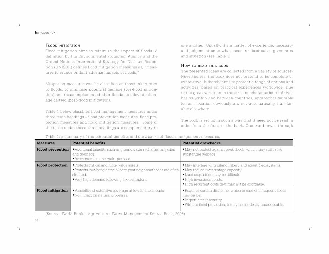
Table 1 below classifies flood management measures under
three main headings – flood prevention measures, flood pro-
tection measures and flood mitigation measures. Some of
the tasks under these three headings are complimentary to
one another. Usually, it’s a matter of experience, necessity
and judgement as to what measures best suit a given area
and situation (see Table 1).
HOW TO READ THIS BOOK
The presented ideas are collected from a variety of sources-
Nevertheless, the book does not pretend to be complete or
exhaustive. It merely aims to present a range of options and
activities, based on practical experiences worldwide. Due
to the great variation in the size and characteristics of river
basins within and between countries, approaches suitable
for one location obviously are not automatically transfer-
able elsewhere.
The book is set up in such a way that it need not be read in
order from the front to the back. One can browse through
INTRODUCTION
Table 1: a summary of the potential benefits and drawbacks of flood-management measures.
Measures Potential benefits Potential drawbacks
Flood prevention •Additional benefits such as groundwater recharge, irrigation and drainage.•Investment can be multi-purpose.
•May not protect against peak floods, which may still cause substantial damage.
Flood protection •Protects critical and high- value assets. •Protects low-lying areas, where poor neighbourhoods are often situated.•Very high demand following flood disasters.
•May interfere with inland fishery and aquatic ecosystems. •May reduce river storage capacity.•Land acquisition may be difficult.•High investment costs.•High recurrent costs that may not be affordable.
Flood mitigation •Possibility of extensive coverage at low financial costs.•No impact on natural processes.
•Requires certain discipline, which in case of infrequent floods may be lost.•Perpetuates insecurity.•Without flood protection, it may be politically unacceptable.
(Source: World Bank – Agricultural Water Management Source Book, 2005)
11
the text and pick up ideas here and there. The different
types of flood management measures – flood prevention,
flood protection, pre-flood mitigation and post-flood miti-
gation are presented in Chapters 2 to 5. A sneak preview
of what is discussed in these chapters is given in Table 2.
since floods are not always a hazard and serve several ben-
eficial purposes as well, chapter 6 discusses the beneficial
use of floods and flood plains. The book concludes with an
annexed reference list of organizations involved in specific
areas of flood management.
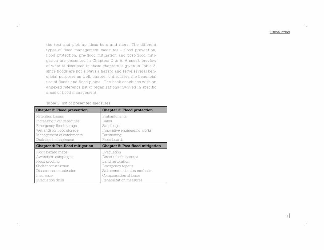
Table 2: list of presented measures
INTRODUCTION
Chapter 2: Flood prevention Chapter 3: Flood protection
Retention basinsIncreasing river capacitiesEmergency flood storageWetlands for flood storageManagement of catchmentsDrainage management
EmbankmentsDamsSand bagsInnovative engineering worksPartitioningFlood boards
Chapter 4: Pre-flood mitigation Chapter 5: Post-flood mitigation
Flood hazard mapsAwareness campaignsFlood proofingShelter constructionDisaster communicationInsurance Evacuation drills
EvacuationDirect relief measuresLand restorationEmergency repairsSafe communication methodsCompensation of lossesRehabilitation measures

12
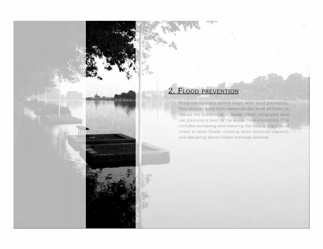
2. FLOOD PREVENTION
Flood management should begin with flood prevention.
This chapter deals with measures that must be taken to
reduce the occurrence of floods. Often, integrated land
use planning is seen as the key to flood prevention. This
includes increasing and restoring the natural capacity of
rivers to store floods, creating more retention capacity
and designing better-linked drainage systems.

14
2.1 INCREASING FLOW CAPACITY AND DIVERSION
Many rivers have been realigned to suit the needs of the
people and communities that live along them. Rivers have
been narrowed, channeled and barricaded. This has lead to
the obstruction of their natural flo w and dynamics. Several
remedial measures are possible to restore river beds to their
natural state and/or enlarge their capacities to store floods.
Such measures also help in groundwater recharge and in
improving ecology.
INTEGRATED APPROACH TO FLOOD MANAGEMENT
Romania
The implications of (past) flood management policy on oth-
er water-related sectors have led the (Prut) basin Water Di-
rectorate to r eview past flood management policy and
practice from a ‘integrated water resources management’
perspective. River bed regulation and dike construction
works (river-shortening by cutting off the old meanders)
contributed to lower flood levels (due to the riverbed de-
cline: morphological changes caused by the modified flow
regime) during high discharge periods. The riverbed de-
cline, however, also lowered the water levels during low
discharge periods (when the demand for water is highest).
As a result, costly (yearly) temporary dams are now con-
structed during low discharge periods to head up and divert
the water to the cut-off rivers arms. Stakeholder represent-
atives in the Jijia Platform summarised the negative impli-
cations for the water supply which serves to: 1)flush the
cut-off meanders (sanitation), 2)recharge (dropping) ground-
water tables (drinking water), 3)deposit ‘rich’ mineral sedi-
FLOOD PREVENTION
EU VISION ON FLOOD MANAGEMENT
The Water Directors of the European Union have approved guidelines,
which call for the development of flood management plans for Euro-
pean river basins. Consideration should be given to the aspect of soli-
darity within the river basin, that is to prevent, as much as is practi-
cally possible, the passing on of problems in one geographical area
into another.
Flood management plans should be based on an integrated approach
covering all relevant aspects of water management, physical planning,
land use, agriculture, transport, urban development and nature con-
servation at all levels (national, regional and local). Decision makers
at all levels, stakeholders and civil society should be involved in the
development of the plan.
A typical flood-management plan should look into the following as-
pects:
- Integrated river-basin approach;
- Public awareness, public participation and insurance;
- Water-retention and non-structural measures;
- Land use, zoning and risk assessment;
- Structural measures;
- Early warning and
forecast systems;
- Flood emergency
measures; and
- Prevention of pollution.
(Source: European Union. Best
Practices On Flood Prevention,
Protection and Mitigation)
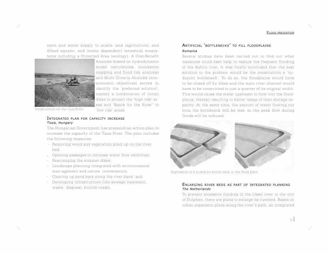
Construction on the Jijia River
15
ment and water supply to arable land (agriculture), and
4)feed aquatic, and (water dependent) terrestrial ecosys-
tems including a Protected Area (ecology). A Cost/Benefit
Analysis (based on hydrodynamic
model calculations, inundation
mapping and flood risk analysis)
and Multi Criteria Analysis (non-
economic objectives) served to
identify the ‘preferred solution’,
namely a combination of (local)
dikes to protect the ‘high risk’ ar-
eas and ‘Space for the River ’ in
‘low risk’ areas.
INTEGRATED PLAN FOR CAPACITY INCREASE Tisza, Hungary
The Hungarian Government has prepared an action plan to
increase the capacity of the Tisza River. The plan includes
the following measures:
- Removing wood and vegetation piled up on the river
bed;
- Opening passages to increase water flow velocities;
- Rearranging the summer dikes;
- Landscape planning integrated with environmental
man agement and nature conversation;
- Clearing up sand bars along the river bank; and
- Developing infrastructure (like sewage treatment,
waste disposal, bicycle roads).
ARTIFICIAL ‘BOTTLENECKS’ TO FILL FLOODPLAINS
Romania
Several studies have been carried out to find out what
measures could best help to reduce the frequent flooding
of the Bahliu river. It was finally concluded that the best
solution to the problem would be the construction a ‘hy-
draulic bottleneck’. To do so, the floodplains would have
to be closed off by dikes and the main river channel would
have to be constricted to just a quarter of its original width.
This would cause the water upstream to flow into the flood-
plains, thereby resulting in better usage of their storage ca-
pacity. At the same time, the amount of water flowing out
from the bottleneck will be less, so the peak flow during
floods will be reduced.
ENLARGING RIVER BEDS AS PART OF INTEGRATED PLANNING
The Netherlands
To prevent excessive flooding of the IJssel river in the city
of Zutphen, there are plans to enlarge its riverbed. Based on
urban expansion plans along the river ’s path, an integrated
Impression of a hydraulic bottle neck in the flood plain
FLOOD PREVENTION
16
master plan has been developed for the area that borders
the city and the river. The plan from Arcadis entails the re-
use of a historic water course of the IJssel river in cases of
high river discharge. The plan advocates the use of low-ly-
ing areas for water storage and higher areas for urban ex-
pansion. Landscape development and nature conservation
projects are also being incorporated into the master plan.
DIVERSION CHANNELS
Canada
In Canada, the Government has constructed a diversion
channel for the Neebing River after it flooded severely
four times in a row, causing extensive damage to the city
of Thunder Bay. The diversion structure at the top of the
channel is designed to divert excess water into the channel
in order to reduce flood damage to residential properties
downstream.
DIKE RELOCATION
Arnhem, The Netherlands
A number of projects are underway in the Netherlands to
clear debris and residue from the Rhine’s riverbed, thereby
creating more space for its flow. The first dike relocation
in the Netherlands was implemented for a branch of the
Rhine near the city of Arnhem.
A new dike was constructed
along the inner side of the ex-
isting dike, hereby creating a
larger floodplain and a reduc-
tion of the water level by 7cm
downstream.
FLOOD DIVERSION THROUGH EXISTING RIVERS
Vietnam
When the dikes and flood retention basins around Vietnam’s
Red River are unable to handle a flood, water is diverted
into the Day River which has the capacity to absorb such
large discharges. This strategy allows for more manageable
flow in the Red River.
CREATING NEW RIVERS BY SAND AND GRAVEL EXTRACTION
The Netherlands
With water levels in rivers expected to rise around the world
due to changing climatic patterns, there is a proposal in
the Netherlands to create entirely new rivers. A benefit of
such a move would be that it would lead to a decrease in
flooding. It can also trigger new ideas and projects in spa-
tial planning and development. Since rivers have a positive
influence on the environment, the surrounding regions will
also benefit. Pathways for the new rivers would be formed
by excavating sand and gravel along the proposed paths.
The project costs could be shared by those profiting from
the land value increase such as property and real-estate de-
velopers,
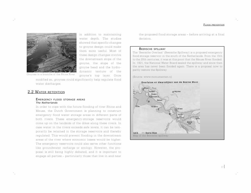
ALTERING GROYNE DIMENSIONS
The Netherlands
In the Netherlands, groynes are used at a number of places
to regulate river flow and ensure that water depth is safe
for navigation. Due to global climatic changes, the frequent
flooding of rivers in the past few years has drawn attention.
Several research studies have been carried out to investi-
gate how existing groynes can be used to regulate flooding,
FLOOD PREVENTION
Map of the Beersche spillway
17
in addition to maintaining
water depth. The studies
showed that specific changes
to groyne design could make
them more useful. Most of
these design changes involve
the downstream slope of the
groyne, the slope of the
groyne head and the hydro-
dynamic texture of the
groyne’s top layer. Once
modified so, groynes could significantly help regulate flood
water discharges.
2.2 WATER RETENTION
EMERGENCY FLOOD STORAGE AREAS
The Netherlands
In order to cope with the future flooding of river Rhine and
Meuse, the Dutch Government is planning to construct
emergency flood water storage areas in different parts of
both rivers. These emergency-storage reservoirs would
come up on the landside of the dikes along these rivers. In
case water in the rivers exceeds safe levels, it can be tem-
porarily be retained in the storage reservoirs and thereby
regulated. This would prevent flooding in the downstream
areas of the river where economic losses would be higher.
The emergency reservoirs could also serve other functions
like groundwater recharge or ecology. However, the pro-
posal is still being highly debated, and it is important to
engage all parties – particularly those that live in and near
the proposed flood storage areas – before arriving at a final
decision.
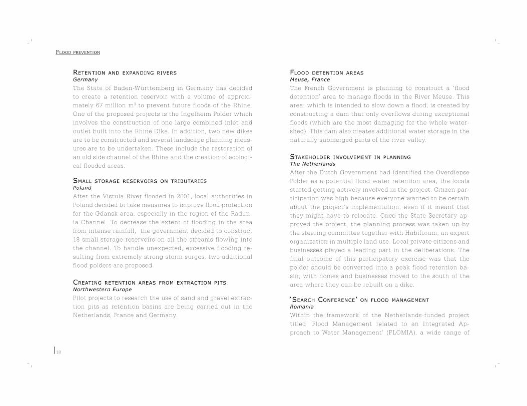
BEERSCHE SPILLWAY
The ‘Beersche Overlaat’ (Beersche Spillway) is a proposed emergency
flood storage reservoir in the south of the Netherlands. From the 15th
to the 20th centuries, it was at this point that the Meuse River flooded.
In 1921, the National Water Board sealed the spillway and since then
the area has never been flooded again. There is a proposal now to
partly restore the Spillway.
(Source: www.monumenten.n)Groynes in a branche of the Rhine River
FLOOD PREVENTION
18
RETENTION AND EXPANDING RIVERS
Germany
The State of Baden-Württemberg in Germany has decided
to create a retention reservoir with a volume of approxi-
mately 67 million m3 to prevent future floods of the Rhine.
One of the proposed projects is the Ingelheim Polder which
involves the construction of one large combined inlet and
outlet built into the Rhine Dike. In addition, two new dikes
are to be constructed and several landscape planning meas-
ures are to be undertaken. These include the restoration of
an old side channel of the Rhine and the creation of ecologi-
cal flooded areas.
SMALL STORAGE RESERVOIRS ON TRIBUTARIES
Poland
After the Vistula River flooded in 2001, local authorities in
Poland decided to take measures to improve flood protection
for the Gdansk area, especially in the region of the Radun-
ia Channel. To decrease the extent of flooding in the area
from intense rainfall, the government decided to construct
18 small storage reservoirs on all the streams flowing into
the channel. To handle unexpected, excessive flooding re-
sulting from extremely strong storm surges, two additional
flood polders are proposed.
CREATING RETENTION AREAS FROM EXTRACTION PITS Northwestern Europe
Pilot projects to research the use of sand and gravel extrac-
tion pits as retention basins are being carried out in the
Netherlands, France and Germany.
FLOOD DETENTION AREAS
Meuse, France
The French Government is planning to construct a ‘flood
detention’ area to manage floods in the River Meuse. This
area, which is intended to slow down a flood, is created by
constructing a dam that only overflows during exceptional
floods (which are the most damaging for the whole water-
shed). This dam also creates additional water storage in the
naturally submerged parts of the river valley.
STAKEHOLDER INVOLVEMENT IN PLANNING
The Netherlands
After the Dutch Government had identified the Overdiepse
Polder as a potential flood water retention area, the locals
started getting actively involved in the project. Citizen par-
ticipation was high because everyone wanted to be certain
about the project’s implementation, even if it meant that
they might have to relocate. Once the State Secretary ap-
proved the project, the planning process was taken up by
the steering committee together with Habiforum, an expert
organization in multiple land use. Local private citizens and
businesses played a leading part in the deliberations. The
final outcome of this participatory exercise was that the
polder should be converted into a peak flood retention ba-
sin, with homes and businesses moved to the south of the
area where they can be rebuilt on a dike.
‘SEARCH CONFERENCE’ ON FLOOD MANAGEMENT Romania
Within the framework of the Netherlands-funded project
titled ‘Flood Management related to an Integrated Ap-
proach to Water Management’ (FLOMIA), a wide range of
FLOOD PREVENTION

Search Conference in Romania
19
stakeholder representatives
from various ministries,
the 11 river basin authori-
ties and non-governmental
organisations were invited
to participate in a ‘Search
Conference’ to brainstorm
and contribute to the elabo-
ration of a national Flood
Management Strategy (FMS). The 3-day program consisted
of plenary sessions focussing on the existing flood manage-
ment policy & practice in Romania, with Dutch state-, wa-
ter board and private sector specialists (Arcadis) presenting
‘lessons learned’ and ‘best practices’ in The Netherlands
(from a national and regional perspective). An outline of the
EU ‘Best Practices on Flood Prevention, Protection and Miti-
gation’ served as a basis for follow-up discussions in small
groups on (priority) topics identified by the participants.
The recommendations presented by each group during the
final plenary session were incorporated in the advice to the
Romanian Waters National Administration (ANAR) and pre-
sented at a final workshop attended by Ministry of Environ-
ment & Water, ANAR and River Basin Authority staff.
The Netherlands
After the government announced plans to widen a narrow
section of a branch of the Rhine River near Nijmegen, local
residents and some special interest groups came up with an
alternative proposal. The residents were against the gov-
ernment proposal because it involved their relocation. Their
alternative proposal suggested the deepening of the flood
plains and river banks, and the construction of a large dike.
This way, the residents would not have to relocate. How-
ever, if the river ’s water level were to rise above the danger
mark in future, the government’s plan would then have to
be implemented.
The alternatives presented by the government (left) and by the inhabitants(right)
Dike relocation to the north. Construction of a large embankment and deepening of flood plains.
FLOOD PREVENTION
20
DECISION MAKING
Retention reservoirs can reduce or prevent flooding on a local or re-
gional scale. Before the decision to build a reservoir is made, the fol-
lowing considerations must be taken into account:
- A reservoir is very expensive and difficult to construct and
maintain, especially in remote mountainous areas. A flood
manager should analyze whether it is worth it or whether other
flood prevention measures could be undertaken.
- The reservoir should be so designed that its dam does
not fail. When a reservoir dam collapses, the flood disaster is
bigger than without the presence of a reservoir.
- The design of the reservoir determines its effectiveness
against flooding. Not only the geometry, but also the
operation and the location of the reservoir are very im
portant.
- Computer models of reservoirs can help to assess their
effectiveness. This helps to decide whether to build a
reservoir and, if so, how it should be designed to
maximize its effectiveness.
(Source: Arcadis, Flood Management in Zakarpattia Region, October
2005)
CROP INSURANCE IN RETENTION AREAS
China
China has experimented with crop insurance in the Yangtze
River Basin, where flooding is usually extreme. The idea of
flood retention reservoirs had run into trouble because resi-
dents were opposed to the use of their villages and agricul-
tural land as retention basins. During a trial period , a crop
insurance program for inundated areas was implemented in
the flood diversion and retention areas of the Huaihe River
Basin. Participation was compulsory and 70% of the premi-
um cost of the insurance was paid by the government. The
program helped overcome the residents’ resistance to use
the basins for flood retention. Also, the cost of the scheme
was spread more equitably by including beneficiaries living
outside the retention basins as contributors.
MAXIMIZING EFFECTIVENESS OF RETENTION RESERVOIRS
Ukraine
The Zakarpattia Flood Protection Program focusses on the
construction of four retention reservoirs in the upper Ter-
esva catchment. Computer programs are to be used in the
operation of the reservoirs to determine when the river is
about to overflow and when to start operating the reser-
voirs.
COMBINING RETENTION WITH OTHER FUNCTIONS
In some cases water retention can be achieved by making
use of existing landscape features. In fact, sometimes these
landscape features, wetlands for instance, can even be im-
proved. Resistance from local residents to flood water reten-
tion, if any, will also generally be less in such cases.
WETLANDS AS FLOOD BUFFERS
Wetlands store heavy rainfalls well, preventing possible
flooding downstream. By storing water in the ground or re-
taining it in surface water sources like lakes, marshes etc,
wetlands reduce the need for expensive, engineered struc-
tures. Wetland vegetation also plays a role in slowing down
the flow of flood water.
By restoring the wetlands in floodplains and managing the
ecology of river basins, governments will not only save huge
FLOOD PREVENTION
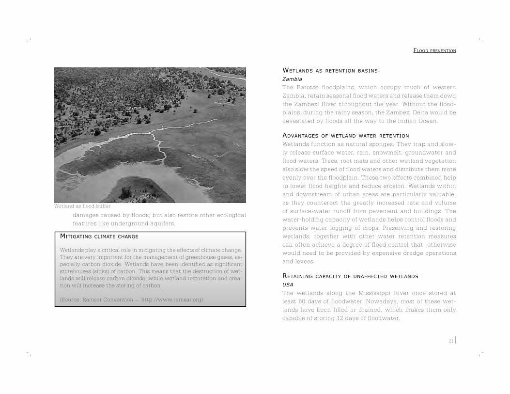
21
damages caused by floods, but also restore other ecological
features like underground aquifers.
MITIGATING CLIMATE CHANGE
Wetlands play a critical role in mitigating the effects of climate change.
They are very important for the management of greenhouse gases, es-
pecially carbon dioxide. Wetlands have been identified as significant
storehouses (sinks) of carbon. This means that the destruction of wet-
lands will release carbon dioxide, while wetland restoration and crea-
tion will increase the storing of carbon.
(Source: Ramsar Convention – http://www.ramsar.org)
WETLANDS AS RETENTION BASINS
Zambia
The Barotse floodplains, which occupy much of western
Zambia, retain seasonal flood waters and release them down
the Zambezi River throughout the year. Without the flood-
plains, during the rainy season, the Zambezi Delta would be
devastated by floods all the way to the Indian Ocean.
ADVANTAGES OF WETLAND WATER RETENTION
Wetlands function as natural sponges. They trap and slow-
ly release surface water, rain, snowmelt, groundwater and
flood waters. Trees, root mats and other wetland vegetation
also slow the speed of flood waters and distribute them more
evenly over the floodplain. These two effects combined help
to lower flood heights and reduce erosion. Wetlands within
and downstream of urban areas are particularly valuable,
as they counteract the greatly increased rate and volume
of surface-water runoff from pavement and buildings. The
water-holding capacity of wetlands helps control floods and
prevents water logging of crops. Preserving and restoring
wetlands, together with other water retention measures
can often achieve a degree of flood control that otherwise
would need to be provided by expensive dredge operations
and levees.
RETAINING CAPACITY OF UNAFFECTED WETLANDS
USA
The wetlands along the Mississippi River once stored at
least 60 days of floodwater. Nowadays, most of these wet-
lands have been filled or drained, which makes them only
capable of storing 12 days of floodwater.
Wetland as flood buffer
FLOOD PREVENTION

22
FARMLAND RETENTION
China
China has beeshifting its focus from flood control to flood
management. The government now promotes reduced reli-
ance on structural flood control measures, and increased
use of non-structural measures like flood damage insurance
and greater use of retention basins and wetlands. A number
of recent projects have been aimed at restoring farmlands
into their former function as wetlands. Along the Yangtze,
Yellow, Huai and
Hai rivers, the
government is re-
converting 98 are-
as from their rural
functions to their
intended flood re-
tention functions.
Although this dis-
rupts the lives of
18 million people,
the government
has been success-
ful in winning their confidence in its ability to mitigate flood
risk while also improving the capacity of households to cope
with controlled flooding within the retention basins.
Tisza Valley, Hungary
Plans are afoot to build a flood retention reservoir for the
Tisza River to water levels by 60 cm. However, since per-
manent storage will be too expensive and harmful from an
ecological viewpoint, water will only be stored temporarily.
This way, farming can also continue to be practiced unhin-
dered.
USING HYDROELECTRIC PLANT RESERVOIRS FOR RETENTION
Vietnam
In addition to a large system of dikes, the Government of
Vietnam has constructed multi-purpose reservoirs on the
banks of the Red River. Though these reservoirs are normal-
ly used for hydroelectric plants, their primary function be-
comes flood water control and regulation during the rainy
season.
2.3 MANAGEMENT OF CATCHMENT AREAS
During heavy rainfall, a number of measures can be taken
to retain and store water in upper catchment areas to re-
duce flood peaks.
SOIL CONSERVATION IN THE UPLANDS
China
Most flood related deaths in China are caused by flash floods,
landslides and mudflows in hilly areas. During the last five
years, the Government of China has converted large parts of
the sloped farmlands into vegetation areas. This vegetation
is meant to prevent future erosion in the hills.
REDUCING IMPERVIOUS SURFACES
In urban areas, many surfaces are impervious to water. This
means water is not retained on the spot, but runs or flows
off to other areas. It is therefore necessary to minimize im-
pervious surfaces so that groundwater retention in such
The Yellow river
FLOOD PREVENTION
23
areas increases. Methods of reducing impervious cover in-
clude critically examining parking needs, using narrower
roads, reducing building setbacks to reduce the length of
driveways and service walks, and using permeable paving
materials.
SELECTIVE USE OF PERMEABLE SURFACES Seine-Normandy Basin, France
Permeable road surfaces are now being used, where pos-
sible, to limit surface rain runoff. This reduces sharp flood
peaks and increases infiltration of rain water into the soil
and hence groundwater recharge.
INCREASING VEGETATION TO PREVENT EROSION
Reforestation is considered one of the best measures to re-
duce erosion and the impact of floods. However trees are
not always
the best way
to prevent
erosion, be-
cause they
need to be
planted very
densely to be
effective. One
useful solu-
tion in this
regard could
be to plant
vetiver grass
on steep hill-
sides, for instance. These grasses have extensive root sys-
tems which bind the earth and reduce erosion within a year
of being planted. Vetiver hedgerows are not invasive and
are raised by cuttings only. Though their planting is labor
intensive, they require little maintenance once planted. In
time, natural terraces begin forming behind vetiver hedge-
rows.
2.4 INTEGRATING DRAINAGE AND FLOOD PREVENTION
MEASURES
Integrating drainage and flood prevention measures is very
important for a number of reasons. For one, when an area
is ‘overdrained’, storm water may quickly accumulate and
surge, causing sharp flood peaks. Large drains could some-
times themselves be sources of local floods. The chances
of such floods increase when these drains are not well-
maintained or otherwise obstructed. In other cases, proper
drainage may avoid water logging and increase the capac-
ity of the soils to ‘buffer ’ floods. It should be remembered
that the converse is also true.
WATER TABLE MANAGEMENT
Drainage can be used to prevent flooding. When severe pre-
cipitation is expected, draining out water from groundwa-
ter tables will bring down their water levels, thus increas-
ing their storage capacity. So when it rains heavily, most of
this water is absorbed by the groundwater tables, which
reduces the chance of flooding downstream.
MODERN DRAINAGE SYSTEMS
In the past, drainage systems were designed to convey as
FLOOD PREVENTION
24
much water as possible out of an area. The idea was that if
water was moved fast enough to another place, there would
be a smaller chance it would flood the area where it has
rained. However, planners now feel this a bad idea as it
only ends up shifting the problem from one area to another,
rather than finding a solution to the problem. That is why
emphasis is now on storage capacity of drains instead of
their conveyance capacity. For example, increasing rough-
ness on the internal surfaces of drains creates friction to
the flow of water and reduces water flow velocity. This way,
rainwater is retained longer in drains which reduces the
risk of flooding in downstream areas.
SLOWING DOWN STORM WATER
Bad drainage in-
frastructure can
aggravate floods
downstream. This
happens when the
network of drainage
pipes and canals do
not have the facil-
ity to store or slow
down the run off.
Without such a sys-
tem, storm water is
transported quickly
to water courses
and rivers, which
may not be able to
absorb the extra dis-
charge. Also the opportunity to recharge groundwater ta-
bles is lost. It is therefore advisable to incorporate into the
drainage network a system of storage or/and slowing down
of water.
GOLF COURSE PONDS FOR RETENTION
Golf-course ponds can be used in storm-water management
in addition to irrigation of the property. These ponds are
designed to blend into the surrounding landscape, creating
visual interest and strategic difficulties throughout the fair-
ways. Retaining water in such ponds could prevent flooding
of low-lying areas.
ROADS AND DRAINAGE
Roads and other infrastructure often cause drainage con-
gestion and water logging. Adequate cross-drainage is
therefore important. On the other hand, roads can also be
used to retain water, which could help in groundwater re-
charge and the prevention of floods. There is great scope to
integrate road planning and flood management.
PAKISTAN
Authorities in Pakistan used drainage systems effectively in
a long-term initiative. Under a series of salinity control and
reclamation projects, they invested in vertical drainage sys-
tems to drain excess water from high water tables. Once this
was done, water tables came down to acceptable levels – a
new equilibrium set in with farmers pumping fresh ground-
water to supplement canal water supplies. This kept water
tables in check in most of the fresh groundwater zones and
allowed closure of public vertical wells which were very ex-
pensive to operate.
FLOOD PREVENTION
25
DRAINAGE TO PREVENT FLOODING IN LOW-LYING LANDS.Kolkata, India
Urban growth on the eastern fringe of Kolkata City has been
partly spontaneous and partly initiated by the government.
This resulted in disrupting the natural course of surface
drainage of basins and creating local floods at low-lying
land areas. Some proposals are under consideration to miti-
gate the effects of flooding in this area, a combination of
which could provide an effective solution. These include:
1. The creation of a number of channels to
accommodate the drainage of water run-off into the
Kulti River;
2. The creation of water bodies to act as reservoirs of
water run-off; and
3. Provision of parks for infiltration and retention.
RECYCLING STORM WATER FOR NON-DRINKING USES
Sydney
In the Sydney Olympic Park, storm water is recycled by us-
ing advanced biological treatment and membrane filtration
technologies. This way, the water is suitable for irrigation
and non-drinking uses such as toilet flushing. The recycled
water is supplied through lilac-colored water meters while
the drinking water is supplied through green-colored me-
ters. The bill for both recycled and drinking water will con-
tain separate, detailed information regarding rates, charges
and water usage. By using large retention ponds in the Park,
water is stored in the area.
STORM WATER USE IN HORTICULTURE
The Netherlands
Instead of using drink-
ing water, the horticul-
tural area of Maasbree
in the Netherlands
uses storm water for
watering plants. To
collect storm water,
there are proposals to
create buffer areas un-
der the ground. One of
the options is the use
of ASR (Aquifer Storage and Recovery), which means water
will be stored in a water containing layer in the soil. This
eliminates the need to construct large and expensive sur-
face reservoirs.
RECYCLING STORM WATER FOR GROUNDWATER RECHARGE
Kolkata, India
The Kolkata Municipal Corporation has stipulated that
storm water from roofs in residential areas is to be chan-
neled through separate conduits into a storage tank where
it is filtered, treated and then recharged into groundwater
aquifers. This system will help reduce drainage problems
in the city. The collection of large monsoon precipitation
can also become a primary source of clean water. Rainwa-
ter harvesting provisions (like water channels and storage
tanks) must therefore become a part of building architec-
ture and construction. This also will help to minimize loads
on regular drains. Further, large open areas in big housing
and commercial projects should be set aside as ‘green cover
Reuse of storm water in Sydney Olympic Park
FLOOD PREVENTION
26
zones’ to be used as children’s playgrounds or recreational
areas. This will prevent storm water run-off and improve
groundwater recharge.
STORAGE OF STORM WATER
Melbourne
Melbourne has a drainage system that carries rainwater
from roofs, roads and buildings through gutters, drains and
channels and discharges it into rivers and creeks, where it
eventually flows to the bays. An important issue is that the
drainage system is kept clear of litter and debris to avoid
blocked drains that can cause flooding. Retarding basins
have also been built around the city, which slow down the
flow of storm water being carried in the drainage system by
storing it for a period of time. The basins also serve other
functions such as parking places or parks.
SUSTAINABLE DRAINAGE SYSTEMS
The Netherlands, Sweden, Germany and Norway
The FLOWS (Floodplain Land Use Optimizing Workable Sus-
tainability) project has undertaken to implement Sustain-
able Urban Drainage Systems (SUDS) in several countries
of Europe. These SUDS aim to reduce flood risk, improve
water quality, recharge groundwater and enhance the po-
tential for biodiversity.
SUDS techniques make use
of filter strips, filter drains,
permeable surfaces, infil-
tration devices and basins
and wetlands. These tech-
niques allow water to infil-
trate into the ground where
it can be retained for long periods of time.
AVOIDING CLOGGING OF DRAINS
Mumbai, India
After heavy recent floods, government authorities in Mum-
bai City decided to ban the use of plastic bags in the city.
This was because the city ’s drains were clogged with plas-
tic bags during the flood and blocked the outflow of water,
which worsened the flooding. Plastic is non-biodegradable
and these all-present plastic bags are an environmental
menace. To make the ban work, the government is planning
to educate the public about the hazards of plastic waste.
SURVEY OF WATER INFRASTRUCTURES
The Netherlands
Once a year, local water boards across the Netherlands per-
form a survey to check the cleanliness of rivers, streams and
brooks, in addition to checking water levels and water-flow
velocities. This is done because throughout the year, veg-
etation like grass and weeds grow along river and stream
beds, hampering the smooth flow of water. This, when cou-
pled with high rains or precipitation, causes water courses
to overflow resulting in flooding.
Bulgaria
To prevent clogging of water courses, the Bulgarian govern-
ment has to objective of regular cleaning of the main river
bed from willows, poplars and bushes, urban solid waste
and large-size industrial waste. The rivers will be checked
before and in human settlements. Attention will also be
paid on clogged sediment in the river soil.
Retention pond for storm water
FLOOD PREVENTION

3. FLOOD PROTECTION
For many years, flood management was equat-ed with flood protection. Constructing dikes and embankments has been the most com-monly-adopted flood protection measure in the past. This is still the case. Only, in addition to flood protection by levees, dikes and embank-ments, now the scope of flood management has increased to include flood prevention and flood mitigation.
This chapter does not discuss the development of dikes and embankments, as this is textbook knowledge by now. Instead, it presents some innovative ideas related to flood protection – particularly on engineering, financing, alter-native flood protection measures and on inte-grating embankment construction with other functions.

An example of an embankment presented in 3D
28
3.1 INNOVATIONS IN ENGINEERING
DESIGNING OPTIMAL EMBANKMENTS
The Netherlands
Reliability Based Design Optimization (RBDO) of flood de-
fence works enables in testing the limits of their reliability
and robustness at the design stage itself. For instance, this
means that the failure probability of a dike design can be
determined before it has been built. Therefore, it is possible
to arrive at the most optimum structural design for each
individual embankment. For larger systems of defences,
the method can be used to first compute the probabilities
of failure of individual structures. These computations can
then be combined to arrive at the maximum flooding prob-
ability for the entire system.
CHECKING EMBANKMENTS WITH AIRBORNE TECHNIQUES
Embankments can be checked upon by using
airborne techniques such as Fast Laser Imag-
ing and Mapping Airborne Platform (FLI-MAP).
One of its main applications is the detailed
mapping of water embankments to asses their
geometric structure. Laser altimetry is a fast,
accurate and cost-saving method to obtain re-
liable and accurate terrain models and topo-
graphic maps. Quick and timely access to this
information may help in the prevention of
floods.
3D-EMBANKMENT MODELLING
Information and data on embankments can
be obtained by laser altimetry using a helicopter. With this
technique, developed by Arcadis, a 3D-structure of the em-
bankment can be computer-generated to an accuracy of
less than 5cm in height and 2 cm in length and width. Spe-
cial software uses the laser-altimetry data to generate 3D-
models of the embankment before and after measures are
taken. The advantage of this technique is that construction
work can start sooner as the 3D-design of the embankment
is already available. Also, calculations on material and soil
quantities are made much easier. It’s even possible to oper-
ate bulldozers from a distance, without a driver, using 3D
vector files.
REINFORCING EMBANKMENTS
Embankments can be reinforced in many ways to prevent
them from breaching. One popular method is to strengthen
the inner slope and crest of the embankment with strong
FLOOD PROTECTION

Stacking sandbags
29
grass vegetation, for instance. This can then be reinforced
by a geo-synthetic wire mesh or an open concrete-block
system. The objective is to slow down the process of erosion
on the embankment’s inner slope and crest after an initial
breach. This method also causes reduction in the width of
the breach. An erosion-resistant layer in or near the em-
bankment will be effective in preventing the breach from
becoming a deep scour hole.
USING VOLUNTEERS FOR EMERGENCY INSPECTION
The Netherlands
In the Netherlands, it is the responsibility of local Water
Boards to conduct quality checks on embankments and take
precautionary measures when needed. In extreme condi-
tions, when water levels are high, volunteers can be de-
ployed to guard some of the embankments.
REINFORCING EMBANKMENTS AT AN EARLY STAGE
Currently, not much attention is given to preventing dis-
asters such as embankment breaches. When there is dan-
ger of an embankment breach, sand bags can be used to
strengthen it, in some cases in combination with a geo-tex-
tile foil. However, these measures may prove to be ineffec-
tive or there may not be sufficient time to accomplish them
in the last minute. That is why preventive measures should
be taken. One method is to strengthen the embankment’s
inner slope and crest with strong grass vegetation, for in-
stance, further reinforced by a wire mesh or an open con-
crete-block system. Additionally, an erosion-resistant layer
in or near the embankment will be effective in preventing
the breach from becoming a deep scour hole.
SAND BAGS
Sand bags can be used in two ways. First, they can be used as rein-
forcements for existing embankments. For this, bags must be placed
on the side of the embankment. Second, they can be used to build a
new embankment. In order to do so, the bags must be stacked upon
each other so that the structure’s width decreases with height. Plastic
sheeting must be used to make the embankment waterproof.
FILLING SANDBAGS
Fill sandbags to half. Sand is preferable if readily available. However,
sand is not mandatory and soil may also be used.
Fold the top of sandbag down and rest the bag on its folded top.
STACKING SANDBAGS
Care should be taken to stack the sandbags in accordance with the il-
lustration. Place each sandbag as shown, completing each layer before
starting the next layer.
(Source: EMA, Australian Emergency Manual Series)
FLOOD PROTECTION

Stone dumping vesselA crane mixes the thickening agent with the humid soil30
NAILING DOWN EMBANKMENTS
One method to restore old embankments to their original
strength is by nailing them down to the ground. This tech-
nique of land reinforcement is comparable to reinforcing
with concrete. The nailing provides the embankment with
more strength, which results in a lower chance of the em-
bankment collapsing.
ENVIRONMENT-FRIENDLY EMBANKMENT REINFORCEMENT
‘Mixed-in-Place’ is an innovative reinforcement technique
in which stabilized ground columns are created at the foun-
dation of the embankment. This is done by adding a thick-
ening agent to the
humid soil at the
foundation, negat-
ing the need for piles
to be driven into the
ground. Therefore,
there is less impact
on groundwater
flows, which makes
the procedure a rel-
atively environment
friendly and cheap.
EXPANDING COLUMNS TO STRENGTHEN SOIL
A new method has
been developed to
strengthen weak
soils around em-
bankments. This involves pushing a column, with a inflat-
able mantle wrapped around it, into the ground. The mantle
is then inflated, which pushes and compresses the soil sur-
rounding it. This makes the soil stronger. The bottom of the
column is secured to the underlying sand layer, which makes
the collapse of the embankment less likely. (Arcadis)
REPAIRING EMBANKMENTS WITH STONE-DUMPING VESSELS
Many damage-control measures can be adopted after a dike
has been breached. One method is to deploy a stone-dump-
ing vessel which can dump rock-fill material into the breach.
The vessel itself can then be lodged in the breach along with
the dumped rock-fill, thus closing off the greater part of the
breach. With further help from helicopters or pontoons, the
complete closure of the breach can be accomplished.
3.2 INTEGRATING EMBANKMENTS WITH OTHER MEASURES
SERIES OF PROTECTION MEASURES
Ukraine
To protect the village of Kvasoso in
the Ukraine from the River Borzhava’s
floods, the following protection meas-
ures were proposed:
- Heightening of the existing
dike along the village;
- Construction of a new dike near
the school;
- Construction of a flood wall;
- Enhancing the Borzhava’s
capacity to absorb the surplus
FLOOD PROTECTION
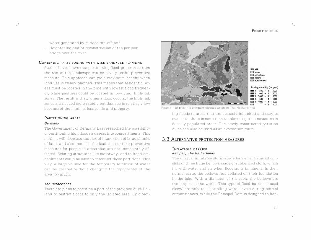
Example of possible compartmentalisation in The Netherlands
31
water generated by surface run-off; and
- Heightening and/or reconstruction of the pontoon
bridge over the river.
COMBINING PARTITIONING WITH WISE LAND-USE PLANNING
Studies have shown that partitioning flood-prone areas from
the rest of the landscape can be a very useful preventive
measure. This approach can yield maximum benefit when
land use is wisely planned. This means that residential ar-
eas must be located in the zone with lowest flood frequen-
cy, while pastures could be located in low-lying, high-risk
zones. The result is that, when a flood occurs, the high-risk
zones are flooded more rapidly but damage is relatively low
because of the minimal loss to life and property.
PARTITIONING AREAS
Germany
The Government of Germany has researched the possibility
of partitioning high flood risk areas into compartments. This
method will decrease the risk of inundation of large chunks
of land, and also increase the lead time to take preventive
measures for people in areas that are not immediately af-
fected. Existing structures like motorway- and railroad-em-
bankments could be used to construct these partitions. This
way, a large volume for the temporary retention of water
can be created without changing the topography of the
area too much.
The Netherlands
There are plans to partition a part of the province Zuid-Hol-
land to restrict floods to only the isolated area. By direct-
ing floods to areas that are sparsely inhabited and easy to
evacuate, there is more time to take mitigation measures in
densely-populated areas. The newly constructed partition
dikes can also be used as an evacuation route.
3.3 ALTERNATIVE PROTECTION MEASURES
INFLATABLE BARRIER
Kampen, The Netherlands
The unique, inflatable storm-surge barrier at Ramspol con-
sists of three huge bellows made of rubberized cloth, which
fill with water and air when flooding is imminent. In their
normal state, the bellows rest deflated on their foundation
in the lake. With a diameter of 8m each, the bellows are
the largest in the world. This type of flood barrier is used
elsewhere only for controlling water levels during normal
circumstances, while the Ramspol Dam is designed to han-
FLOOD PROTECTION

The Thames barrier
The inflatable barrier at Ramspol in action
32
dle substantial storms. This flood barrier provides effective
protection from high tide, does not obstruct navigation and
is relatively cheap
MAESLANT FLOOD BARRIER
The Netherlands
The Maeslant Flood
Barrier is a mobile
flood barrier in the
Nieuw Waterweg
near the Hook of
Holland. This com-
manding storm-
flood barrier con-
sists of two colossal,
hollow, arched doors, each 300m long. When a storm surge
reaches three metres above NAP (Dutch term for Normal
Amsterdam Water Level), a computer-monitoring system
shuts the barrier and seals off the Nieuw Waterweg.
STEEL RIVER BARRIER
London, United Kingdom
The Thames Barrier is a series of ten separate movable gates
positioned end-to-end across the river. Each gate is pivoted
and supported between concrete piers that house the op-
erating equipment. Closing the barrier seals off part of the
upper Thames from the sea. When not in use, the six rising
gates rest out of sight in curved recessed concrete cills in
the riverbed, allowing free passage of river traffic though
the openings between the piers. If a dangerously high tidal
surge threatens, the rising sector gates are moved up and
the four radial gates are bought down into the closed de-
fence position. The gates thus form a continuous steel wall
facing down-river ready to stop the tide.
TSUNAMI PROTECTION CONSTRUCTIONS
Although tsunamis cannot be stopped, their impact can be
lessened by undertaking certain measures and construc-
tions. These include:
- Slowing techniques – constructing forests, ditches,
slopes etc which create friction and reduce the
destructive power of waves;
- Steering techniques – constructing angled walls
and ditches which guide the force of tsunamis away
FLOOD PROTECTION

Deployment of a flood board
33
from vulnerable structures and people; and
- Blocking techniques – constructing walls including
compact terraces and berms which acts as barriers to
the waves.
CITY WALLS AS FLOOD BARRIERS
Kampen, The Netherlands
Because dams around the city of Kampen were not adequate
to handle existing water levels, some old structural rem-
nants from the Middle Ages are used to protect the city from
the IJssel River. These additional flood defence structures
include old city walls, some houses and gardens. While rein-
forcing these old structures to strengthen them, their char-
acteristic physical attributes are being retained as much as
possible, to maintain their aesthetic appeal.
MANGROVE TREES AS FLOOD BARRIERS
Vietnam
It was noted in Vietnam that mangrove trees lining some
parts of the country ’s coast, initially planted by the Red
Cross for environmental reasons, functioned as a good,
strong green wall in protecting sea dikes against strong ty-
phoon waves. With a sufficient number of trees, waves as
high as 1.5m can be completely neutralized.
FLOODING BOARDS
Dordrecht, The Netherlands
With water levels expected to rise in the future, houses in
the city of Dordrecht are being designed to become part of
the city ’s flood defence system. Since a number of shops are
situated on the city ’s dike, each of their doorways is a po-
tential gap in the flood defence system; necessitating their
closure in case water overtops the dike. This is achieved
with the help of flood boards. Since all the doors have the
same standard size, standardized flood boards are used for
the purpose. The local Water Board holds a stock of these
flood boards; every year an exercise is conducted during
which all these boards are tested by sealing off the door-
ways. An inspector is appointed for every street who then
checks the boards for failures. (Arcadis)
ARTIFICIAL REEFS FOR COASTAL PROTECTION
The Netherlands
A plan is being developed to protect the North Sea Coast in
The Netherlands from erosion and rising sea level. By plac-
ing an artificial reef on the bottom of the sea, about 50 % of
FLOOD PROTECTION
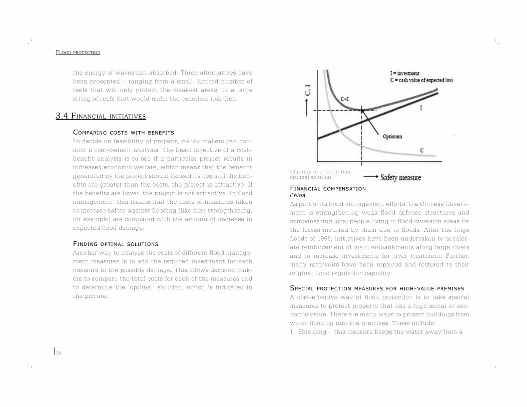
Diagram of a theoreticaloptimal solution
34
the energy of waves can absorbed. Three alternatives have
been presented – ranging from a small, limited number of
reefs that will only protect the weakest areas, to a large
string of reefs that would make the coastline risk-free.
3.4 F INANCIAL INITIATIVES
COMPARING COSTS WITH BENEFITS
To decide on feasibility of projects, policy makers can con-
duct a cost–benefit analysis. The basic objective of a cost–
benefit analysis is to see if a particular project results in
increased economic welfare, which means that the benefits
generated by the project should exceed its costs. If the ben-
efits are greater than the costs, the project is attractive. If
the benefits are lower, the project is not attractive. In flood
management, this means that the costs of measures taken
to increase safety against flooding (like dike strengthening,
for example) are compared with the amount of decrease in
expected flood damage.
FINDING OPTIMAL SOLUTIONS
Another way to analyze the costs of different flood manage-
ment measures is to add the required investment for each
measure to the possible damage. This allows decision mak-
ers to compare the total costs for each of the measures and
to determine the ‘optimal’ solution, which is indicated in
the picture.
FINANCIAL COMPENSATION
China
As part of its flood management efforts, the Chinese Govern-
ment is strengthening weak flood defence structures and
compensating local people living in flood diversion areas for
the losses incurred by them due to floods. After the huge
floods of 1998, initiatives have been undertaken to acceler-
ate reinforcement of main embankments along large rivers
and to increase investments for river treatment. Further,
many reservoirs have been repaired and restored to their
original flood regulation capacity.
SPECIAL PROTECTION MEASURES FOR HIGH-VALUE PREMISES
A cost-effective way of flood protection is to take special
measures to protect property that has a high social or eco-
nomic value. There are many ways to protect buildings from
water flooding into the premises. These include:
1. Shielding – this measure keeps the water away from a
FLOOD PROTECTION

When a building is sealed, measures are taken to make the construction water-proof. This will protect valuable assets agains flood damage
35
building and may influence the spreading and intensity
of flooding. Shielding must not increase the risk to other
properties in the vicinity;
2. Elevation – this is a very efficient and cheap method to
protect new buildings. A construction can be elevated
by the use of:
a. Supports, which leaves possibilities for creative
development. Also the space under the building can be
used;
b. Walls, which extends the buildings’ possibilities of use;
and
c. Dams, which is cheap in cases of slopes nearby and is
useful when groundwater levels are high;
3. Permanent or mobile flood walls – the construction of an
embankment or wall is a permanent measure.
Temporary measures are constructions that may be
lifted or tipped up. In case of longer warning lead times,
mobile systems using stop logs, and sand bags may be
applied.
Switzerland
The business premises of the Seehof in Luzern, Switzerland,
is a building that has been sealed to prevent flooding. The
construction consists of four basement floors and four up-
per floors. All the technical installations of the building are
located in the basement floors. If the construction had not
been sealed, a flooding would cause a disruption to busi-
ness activities for several months. The sealing consists of
mobile defences that protect the low-lying entrances. Al-
though the measures were expensive to implement, they
protected and preserved the premises from large damages
during the flooding in 1999.
RED FOR BLUE
Netherlands
Red for Blue is an innovative concept in water management.
Red stands for bricks or real estate, and therefore signifies
the real-estate industry. Similarly blue stands for water,
and signifies the water board or water authority. There are
opportunities for the real-estate sector to participate and
profit from flood management for instance by investing in
measures constructing water-storage facilities, Since this
service is provided to the water company/authority for a
fee, the real-estate sector registers a ‘value addition’. Such
strategies require intense collaboration between private-
party developers and the government. An example of such
an integrated project is the ongoing
‘Nieuwe Hollandse Waterlinie’. The master plan for the
project includes an area of 20,000 ha which has to integrate
concepts of water- and flood management, urban plan-
FLOOD PROTECTION

Flood damage in Bulgaria
36
ning and design, landscape architecture, and housing. The
project is managed by a board representing regional au-
thorities. Sensing the potential of the project, several pri-
vate-property developers took the initiative to invest in it.
Of the 180 million euro cost of the project, nearly 40% was
recovered from real-estate investments.
FLOOD PROTECTION

4. PRE-FLOOD MITIGATION
Even with prior knowledge that flooding will occur in some areas, it will not always be pos-sible to keep flood waters away due to several logistical or practical reasons. In such cases, there are measures that can be taken to mini-mize flood impact. These include flood proof-ing, raising awareness and flood preparedness. Often, such measures and plans are based on flood-hazard maps.

38
4.1 FLOOD PROOFING
Flood proofing measures aim to make building construc-
tions flood resistant. This can be done either by designing
constructions to withstand water intrusion or by elevating
buildings above the ground.
PREVENTING BUILDING COLLAPSE BY LETTING IN WATER
When floods threaten a building, the tendency is to keep the water
out as long as possible. This is a good idea only as long as the build-
ing is still stable, which is usually when the waterdepth is less than
one meter above the ground. Studies show that masonry structures
start to fail when this water depth rises above 1.5m. If the water level
continues to rise, it is best to flood the building with clean water or let
water in from outside.
(Source: Kreibich, H. et al., Precautionary measures reduce flood losses
of households and companies – insights from the 2002 flood in Saxony,
Germany)
FLOOD-ADAPTED INFRASTRUCTURE
Flood-adapted infrastructure can help minimize the dam-
aging impact of floods on people and property. This can be
achieved by:
1. Improving construction of houses and buildings – that
is, constructing houses with raised plinths, cement,
baked brick walls and flat roofs (on which to build stor
age lofts in case of emergencies) etc;
2. Elevating villages above normal inundation levels.
This way, the water cannot enter homes during
normal floods;
3. Designing water supply systems that cannot be easily
polluted. Installing hand pumps at roof level is also an
effective measure in this regard;
4. Constructing flood drainage systems. It is important to
develop designs for roads, railways and other
infrastructure that increase rather than restrict
drainage; and
5. Constructing irrigation systems that are resilient to
flood damage.
FLOOD ADAPTED INTERIORS
One of the best ways to prevent loss to property during
floods is to make sure that the cellars and lower floors are
not expensively designed and furnished. Instead, designing
flood-prone parts of a building with water-proof building
material and designing interiors with small, movable fur-
nishings would be a better idea. Further, having tiled floors
instead of carpeted ones and installing electric and heating
utilities on higher floors can reduce damage significantly,
for instance.
FLOOD ADAPTED CONSTRUCTION
When building a new house, it makes financial sense to take
the risk of flooding into account. There are many ways to
reduce damage in case of flooding. These include:
1. Avoiding the construction of a cellar or basement
floor in the building.
2. Using water-proof material to insulate oilbased
heating systems. Alternatively, installing a gas
heating system instead of an oil heating system may
PRE-FLOOD MITIGRATION

Houses built on levees39
also help reduce costs.
3. Installing master switches and
electricity distribution boxes
above inundation levels allows the
use of the upper floors even
during floods.
4. Using water-resistant materials in
the construction and/or finish
could help lower cleaning costs.
USE OF LEVEES
The Netherlands
In the past, when there was inadequate flood protection in
low-lying areas, farm-houses in many areas were construct-
ed on levees. When floods occurred, property was spared
and only farmlands were flooded. The idea of constructing
houses on levees built of sea/river sludge is being explored
again. With sea-levels rising and encroaching on land due
to global warming, it is expected that there will be much
dredging sludge available in the decades to come. Levees
built with such sludge could be inland extensions of river
dikes and could function as backyards of houses. Over time,
the soil in the levees will bind together and finally form a
solid layer of ground.
CONSTRUCTING HIGH-LYING EVACUATION ROADS Vietnam
In areas prone to extreme flooding, landfill is brought in to
create elevated ‘anti-flood’ platforms for entire villages. The
process also requires the construction of high-lying evacu-
ation roads leading to the villages to ensure access during
floods and to use as escape routes.
FLOOD-FREE TERRACES
India
For many people in India, living in cement-and-brick houses
with high flat roofs (pakka) has proved to be invaluable in
protecting their property and assets. In times of flood, valu-
ables can be stored on the terrace roofs where they are out
of the reach of water. Even to take refuge, people can climb
on to their terraces without leaving their houses and are
therefore able to protect their valuables from theft. If the
terrace has walls and a roof, belongings can also be hung
with ropes and nails.
USING VEGETATION TO PREVENT EROSION
India
When houses or entire villages are built using mud, they
become very vulnerable to erosion. To prevent such erosion
of houses and entire villages, people from flood-prone areas
in India grow vegetation like bamboo, grass, creepers etc to
bind the earth together and thereby strengthen it.
PRE-FLOOD MITIGRATION
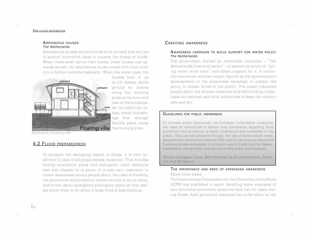
Drawing of a floating villa
40
AMPHIBIOUS HOUSES
The Netherlands
Amphibious houses are structures built on land and are one
of several innovative ideas to counter the threat of floods.
When rivers swell above their banks, these houses rise up-
wards as well. An amphibious house comes with foam built
into a hollow concrete basement. When the water rises, the
houses float to up
to 5.5 meters above
ground by sliding
along two mooring
poles at the front and
rear of the buildings.
All the electrical ca-
bles, water and sew-
age flow through
flexible pipes inside
the mooring piles.
4.2 FLOOD PREPAREDNESS
To mitigate the damaging impact of floods, it is very im-
portant to take flood preparedness measures. This includes
having evacuation plans and emergency relief measures
(see also chapter 5) in place. It is also very important to
create awareness among people about the risks of flooding,
the preventive and protection measures that must be taken,
and finally about emergency evacuation plans (so that peo-
ple know what to do when a large flood is approaching).
CREATING AWARENESS
AWARENESS CAMPAIGN TO BUILD SUPPORT FOR WATER POLICY
The Netherlands
The government started an awareness campaign – “The
Netherlands lives with water” – to explain its policy of “giv-
ing water more room” and obtain support for it. A nation-
ally-renowned weather expert figured as the government’s
spokesperson in the awareness campaign to explain the
policy in simple terms to the public. The expert educated
people about the diverse measures and efforts being under-
taken by national and local authorities to keep the country
safe and dry.
GUIDELINES FOR PUBLIC AWARENESS
To increase public awareness, the European Commission underlines
the need for authorities to ensure that information regarding flood
prevention and protection is easily understood and accessible to the
public. This can be achieved through the use of flood-hazard maps,
geographical information systems (GIS) and by carrying out educative
flood awareness campaigns. Information about floods must be dissem-
inated early and actively, and should involve public participation.
(Source: European Union. Best Practices On Flood Prevention, Protec-
tion and Mitigation)
THE IMPORTANCE AND NEED OF SPREADING AWARENESS
Rhine rover basin
The International Commission for the Protection of the Rhine
(ICPR) has published a report detailing some examples of
non-structural protection measures that can be taken dur-
ing floods. Such protection measures are to be taken on the
PRE-FLOOD MITIGRATION
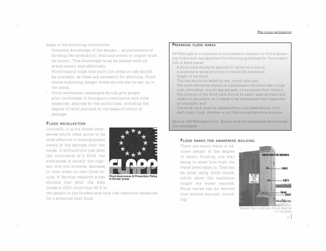
Marks that indicate flood depths in the past
41
basis of the following information:
- Complete knowledge of the danger – all parameters of
flooding like probability, kind and extent of impact must
be known. This knowledge must be shared with all
actors clearly and effectively.
- Flood-hazard maps that point out areas at risk should
be available, as these are necessary for planning. Flood
marks indicating danger levels should also be set up in
the areas.
- Flood awareness campaigns should give people
prior knowledge of emergency evacuation and relief
measures planned by the authorities, including the
degree of relief planned on the basis of extent of
damage.
FLOOD RECOLLECTION
Ironically, it is the floods them-
selves which often prove to be
most effective in making people
aware of the damage they can
cause. It is found that just after
the occurrence of a flood, the
awareness is usually the high-
est; this will however decrease
in time when no new flood oc-
curs. A German research study
showed that after the Elbe
floods of 2002, more than 40 % of
the people in the flooded area took risk-reduction measures
for a potential next flood.
PREPARING FLOOD MARKS
HR Wallingford, a consultancy and research company in civil engineer-
ing hydraulics, has specified the following guidelines for the prepara-
tion of flood marks:
- A flood mark should be painted or carved as a line on
a concrete or stone structure to record the maximum
height of the flood;
- The line should be dated by day, month and year;
- The mark should be placed on a permanent structure like a huge
rock, a building, on a bridge parapet, or a purpose-built column;
- The location of the flood mark should be easily approachable and
visible to the public; so it needs to be maintained well (repainted
for example); and
- The flood mark must be updated from local observations with
each major flood, whether or not they exceed previous maxima.
(Source: HR Wallingford Ltd., Source book for sustainable flood mitiga-
tion strategies)
FLOOD MARKS FOR AWARENESS BUILDING
There are many ways to ed-
ucate people of the degree
of recent flooding; one way
being to show how high the
water level came to. This can
be done using flood marks,
which show the maximum
height the water reached.
Flood marks can be derived
from several sources, includ-
ing:
PRE-FLOOD MITIGRATION

42
- Water-level marks on measuring scales to indicate peak
water levels. These levels must be marked permanently
so they do not fade away;
- Anecdotal information provided by residents about
water depths during the floods;
- Marks made by garbage/trash on walls or wallpapers in
houses; or debris such as plastic bags that got stuck on
the branches of a tree indicate water levels; and
- Photographs that were taken of the floods or the marks
it has left.
FLOOD PREPAREDNESS PLANS
EMERGENCY PLANS
Switzerland
The asbestos-cement industry
in Niederurnen, Switzerland, de-
veloped a flood emergency plan
that helped the industry avoid
flood damage that could have
run into millions of dollars and
could have caused long-term
physical disruption to their busi-
nesses. The plan consisted of:
- Organizing a team of trained
flood-relief volunteers;
- Organizing a team for filling
sandbags;
- Planning for an emergency
power-supply back-up system;
- Testing and retrofitting tank installations to prevent
them from floating;
- Setting up a floodwarning alarm station; and
- Having emergency plans for different degrees of
flooding.
EMERGENCY MANAGEMENT AUSTRALIA (EMA)Australia
EMA assists states and territories in Australia
to develop their emergency management ca-
pabilities. The EMA also coordinates Austral-
ian Government physical assistance to states
and territories, upon request, during major
disasters. The EMA promotes a national ap-
proach to emergency management in Aus-
tralia through comprehensive measures which embrace prevention,
preparedness, response and recovery activities.
(Source: EMA, Australian Emergency Manual Series)
COMMUNITY FLOOD MANAGEMENT PLANS
Bangladesh
The World Meteorological Association (WMO), is implement-
ing the ‘Community Approaches to Flood Management’
project in Bangladesh as part of its mission for South Asia.
The project has specific plans regarding:
- Weather-bulletin dissemination;
- Relocating marooned people;
- Flood shelter management;
- Health care;
- Distribution of potable water; and
- Livestock management.
PRE-FLOOD MITIGRATION

Preparedness training
43
MOCK DRILLS
India
The Orissa Disaster Management Project (ODMP), a col-
laborative project between the Government of Orissa and
the UNDP, has prepared community contingency plans for
1,600 villages in the state of Orissa, starting with partici-
patory risk assessment and mapping. These plans included
the identification of school buildings that could double as
flood shelters, installation of raised tube wells, construction
of warehouses for storage of nets and dry fish, repairs of
roads and embankments, and exploring alternative build-
ing technologies. Mock drills followed up the contingency
plan.
DISASTER PLANS
The ODMP has also recommended that the following meas-
ures be undertaken in case of disasters:
- Integration of community plans into sub-district
disaster management plans;
- Establishment of trained, local task-force groups to
manage first aid, rescue evacuation, water and
sanitation, shelter management and body disposal; and
- Development of a radio network to be used during
emergency and establishment of control rooms in
the sub-districts.
VOLUNTEER TRAINING
Bangladesh
In Bangladesh, volunteers have been trained to warn and
help people in case of disasters such as cyclones. They reg-
ularly undergo simulation drills and hold meetings to raise
awareness and disseminate useful information.
INDIA
The World Meteorological Association (WMO) is implement-
ing the ‘Community Approaches to Flood Management’
project in India as part of its mission for South Asia. The
project involves the training of volunteers to assist and sup-
port the Flood Management Committee during and after
floods. The volunteers attend extensive, one-day training
workshops in the areas of their tasks, which include:
- Agriculture, plantation and aquaculture/fish culture;
- Health and sanitation;
- Livestock management; and
- Rescue, temporary flood shelters and relief operations;
Further, the members of the
Flood Management Commit-
tee are asked to send regular
reports as part of their moni-
toring process to enable tak-
ing advance measures, there-
by reducing the negative
impact of floods.
TRAINING OF FISHERMEN IN FLOOD-PRONE AREAS
Thailand
The Food and Agricultural Or-
ganization (FAO) has drawn
up a list of medium and long-
term measures that need to
be undertaken in flood-prone
areas of Thailand. The follow-
PRE-FLOOD MITIGRATION

Flooded industry buildings
44
ing measures have been specified for villages:
- Educating fishing communities regarding natural
disasters and sea safety;
- Training fishermen in boat building and repairing;
- Capacity-building measures for village fishermen
organizations in micro-credit financing and revolving
fund management;
- Training in alternative marine-based livelihoods such as
sea farming or offshore cage culture of fish; and
- Planning for disaster recovery with village fishermen
organizations, with particular focus on improving
quality of life.
FLOOD COMMITTEES
Bangladesh
In Bangladesh, a flood committee was established in each
flood-prone area to take active part in local governance and
decision making. The committee maintained close liaison
with the administration and would place written demands
for relief and rehabilitation assistance, as need be. Volun-
teers at the community level collected flood-damage infor-
mation and passed it to the committee, which used the in-
formation as a basis to arrive at the extent of flood damage
and identify its worst victims.
PREPAREDNESS ACTIONS FOR BUSINESSES
SAFE STORAGE OF HAZARDOUS SUBSTANCES
During a flood, hazardous effluents and substances may get
released into the environment not only from industries and
factories, but also in residential and agricultural areas. Oil,
chemicals and pesticides are a couple of such examples. To
avoid wastage of these
substances and to pre-
vent them from polluting
the environment, they
must be stored in elevat-
ed areas out of the reach
of water, or transported
away. It is important
to have an idea of such
stored substances on the
basis of their toxicity,
their inflammability, explosiveness and their ecotoxicity.
EMERGENCY PLANS FOR ORGANIZATIONS
To be able to respond to emergencies like floods, organiza-
tions need to have an effective emergency plan in place.
This would help to avoid confusion during a disaster situ-
ation as people would know what to do. Such a plan also
reduces damage to life and property, and saves crucial time
(otherwise spent in chalking out last-minute plans). Further,
an emergency plan is always strongly focused on ensuring
maximum safety.
FLOOD TRAINING AND EVACUATION PLANS
UK
The Environment Agency in the United Kingdom has de-
veloped a handbook for businesses on how to conduct staff
training for flood evacuation. The training enables employ-
ees to quickly and efficiently take damage-control measures
in case of a flood, and to protect themselves and their busi-
ness. It helps to ensure that the evacuation is done in an
PRE-FLOOD MITIGRATION

Example of a map from the Rhine Atlas45
organized and safe manner. Training programs vary from
a ready-to-use information checklists to a full evacuation
drill.
What goes into developing an effective organizational emer-
gency plan?
- The attitude of the management should be proactive.
- The management must communicate the importance
and necessity of the emergency plan to the staff.
- The management must ensure that the plan can be and
is actually implemented.
- Policy changes in support of the emergency plan must
be made as the need arises.
- An adequate budget must be earmarked for the
plan.
POLLUTION DUE TO FLOODS
Flood waters carry with them numerous harmful
contaminants, and transport these pollutants across
many miles. This poses a great risk to groundwater
quality, since a number of underground aquifers
that feed all private wells are recharged by surface
water (which could be contaminated).
FLOOD HAZARD MAPS
THE UTILIZATION OF FLOOD-HAZARD MAPS
Japan
In Japan, flood-hazard maps have proved to be
very useful in preparing people to handle disasters
like floods. The maps enable people to see an ap-
proaching flood and evacuate promptly. The effec-
tiveness of the maps can be judged by the following fact
– Over 30% of people that saw the maps evacuated within 6
hours of seeing them. However, this number dropped to 20%
among those that did not see the maps.
RHINE ATLAS
Rhine river basin
The ICPR has created flood-hazard maps for people living
along the river Rhine. These maps show the different ex-
tents to which flooding could occur in different areas, and
how high water levels could rise even in unexpected cases.
Large-scale flood-hazard maps are designed using compu-
ter modeling. Earlier, flood forecasts were made based on
PRE-FLOOD MITIGRATION

Example of flood hazard zonation
46
marks or signs left behind from an earlier flood. However,
now computer programs help to determine the scope, ex-
tent and depth of flooding in a specific area. The programs
also provide data on flood velocity and direction for any lo-
cation at any time.
EXTENDABLE HAZARD MAPPING SYSTEM
The Netherlands
As part of its national safety policy, the Dutch Government
has developed a Flood Management System that helps to
assess the possibility of a flood to occur at a given place
and the damage it could cause. The system also provides
information on what action can be taken to minimize risks;
thereby helping in drawing up evacuation plans, designat-
ing overflow areas and for spatial planning. The system has
been designed as a set of modules, making it flexible and
easy to develop as it can be expanded by attaching new
modules.
REAL-TIME HAZARD MAPS
Seine-Normandy Basin, France
People living in the Seine-Normandy Basin area are aware
of the flood risks it poses. As an effective flood preparedness
measure, the Government of France operates a website that
hosts real-time hazard maps of the basin. On the website,
people can zoom in on specific areas of the river basin to get
real-time information on weather conditions, water levels
and the possibility of floods in that area.
RISK CLASSIFICATION
Germany
In order to have a logical and fair basis for claiming flood
insurance, a zoning
system has been devel-
oped in Germany that
specifies the threat
different areas in the
country face from
floods. Data regarding
discharge velocities of
water (in case of flood-
ing) was used to compute corresponding water levels at any
given point along chosen water courses. Then, based on
these computations, each area was divided into one of four
zones based on the risk assessment for that area.
FLOOD RESILIENCE
Resilience is a new concept in flood management that is
used to predict the strength and effectiveness of a certain
system of measures. Studying the resilience of a flood risk
management system, for instance a polder surrounded by
dikes, gives an idea of how it will react to flooding. The
final objective of any flood resilience strategy is to mini-
mize flood impact and hasten recovery. This is in contrast
with the concept of flood resistance, which aims to prevent
floods entirely.
CALCULATING FLOOD RISK
Flood risk can be estimated for alternative measures by:
1. Calculate the maximum water level with a
hydrodynamic model and the extent of flooded area
(Digital Terrain Model) for floods with different return
periods (T=10, T=20, T=50, T=100 etc.);
PRE-FLOOD MITIGRATION
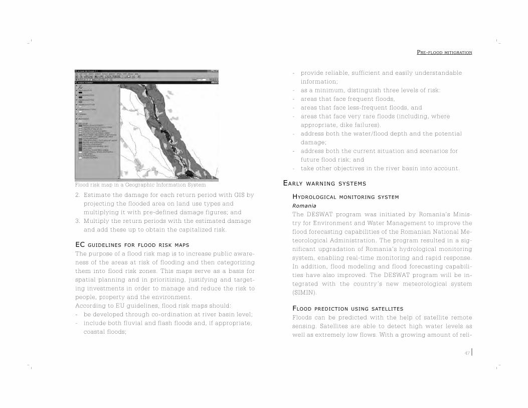
Flood risk map in a Geographic Information System
47
2. Estimate the damage for each return period with GIS by
projecting the flooded area on land use types and
multiplying it with pre-defined damage figures; and
3. Multiply the return periods with the estimated damage
and add these up to obtain the capitalized risk.
EC GUIDELINES FOR FLOOD RISK MAPS
The purpose of a flood risk map is to increase public aware-
ness of the areas at risk of flooding and then categorizing
them into flood risk zones. This maps serve as a basis for
spatial planning and in prioritizing, justifying and target-
ing investments in order to manage and reduce the risk to
people, property and the environment.
According to EU guidelines, flood risk maps should:
- be developed through co-ordination at river basin level;
- include both fluvial and flash floods and, if appropriate,
coastal floods;
- provide reliable, sufficient and easily understandable
information;
- as a minimum, distinguish three levels of risk:
- areas that face frequent floods,
- areas that face less-frequent floods, and
- areas that face very rare floods (including, where
appropriate, dike failures).
- address both the water/flood depth and the potential
damage;
- address both the current situation and scenarios for
future flood risk; and
- take other objectives in the river basin into account.
EARLY WARNING SYSTEMS
HYDROLOGICAL MONITORING SYSTEM
Romania
The DESWAT program was initiated by Romania’s Minis-
try for Environment and Water Management to improve the
flood forecasting capabilities of the Romanian National Me-
teorological Administration. The program resulted in a sig-
nificant upgradation of Romania’s hydrological monitoring
system, enabling real-time monitoring and rapid response.
In addition, flood modeling and flood forecasting capabili-
ties have also improved. The DESWAT program will be in-
tegrated with the country ’s new meteorological system
(SIMIN).
FLOOD PREDICTION USING SATELLITES
Floods can be predicted with the help of satellite remote
sensing. Satellites are able to detect high water levels as
well as extremely low flows. With a growing amount of reli-
PRE-FLOOD MITIGRATION

48
able data at the disposal of experts, it is becoming increas-
ingly possible to predict where and when major flooding
will occur, and to analyze trends over time.
MANUAL FOR FLOOD WARNING SYSTEMS
Australia
The Australian Emergency Manual identifies the following six compo-
nents as important in an effective flood warning system:
- Prediction: Detecting changes in the environment that lead to
flooding and predicting river levels during the flood;
- Interpretation: Identifying, in advance, the impacts of the
predicted flood levels on communities at risk;
- Message construction: Producing the content of the message
which will warn the people;
- Communication: Distributing warning information in an
appropriate way to people and organizations that are likely to be
affected by the flood;
- Response: Generating appropriate actions from the threatened
community and from agencies involved; and
- Review: Examining the various aspects of the system to improve
its performance.
(Source: EMA, Australian Emergency Manual Series)
INTEGRATING FLOOD WARNING SYSTEMS
Europe
After the disastrous floods in the Elbe and Danube river ba-
sins in 2002, the European Commission announced the de-
velopment of a European Flood Alert System (EFAS).
This alert system will be able to provide medium-range flood
simulations across Europe with a lead-time ranging between
3 to 10 days. The system offers two advantages. First, it
provides the European Commission with useful information
for the preparation and management of aid during a flood
crisis. Second, na-
tional water au-
thorities would
be able to use the
information to in-
crease their preparedness in case of an impending flood.
EFAS is aimed at complementing national flood forecasting
systems, not at replacing them.
LOW-COST WARNING SYSTEMS
Thailand
To reduce the risk of flooding, simple rain gauges and man-
ual warning sirens have been installed in the village of Mae
Kampong. This equipment is used for observing local flood
conditions and issuing forecasts and warnings to villagers.
The rain gauge comes very cheap and is simple to use. Vil-
lage volunteers are trained to measure, record and read the
daily amount of rainfall. When the amount of rainfall ex-
ceeds the predefined normal level, the volunteer in charge
of observations will issue a warning by using the manual
siren. The village headman will then spread the warning
through the village news broadcasting tower. (ADRC)
COMMUNICATION
WARNING SIRENS
The Netherlands
Communities in the Netherlands have emergency sirens in-
stalled which are tested once every month. These sirens are
sounded to warn people of impending disasters, and since
PRE-FLOOD MITIGRATION
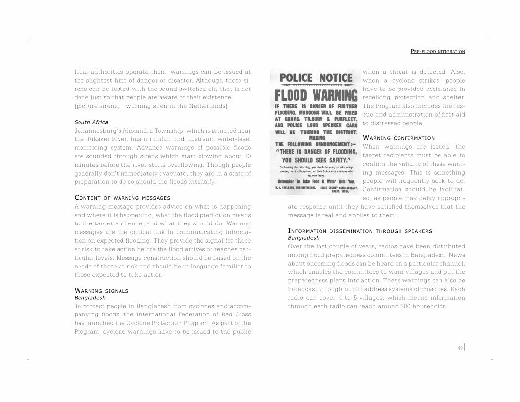
49
local authorities operate them, warnings can be issued at
the slightest hint of danger or disaster. Although these si-
rens can be tested with the sound switched off, that is not
done just so that people are aware of their existence.
[picture sirene, “ warning siren in the Netherlands]
South Africa
Johannesburg’s Alexandra Township, which is situated near
the Jukskei River, has a rainfall and upstream water-level
monitoring system. Advance warnings of possible floods
are sounded through sirens which start blowing about 30
minutes before the river starts overflowing. Though people
generally don’t immediately evacuate, they are in a state of
preparation to do so should the floods intensify.
CONTENT OF WARNING MESSAGES
A warning message provides advice on what is happening
and where it is happening, what the flood prediction means
to the target audience, and what they should do. Warning
messages are the critical link in communicating informa-
tion on expected flooding. They provide the signal for those
at risk to take action before the flood arrives or reaches par-
ticular levels. Message construction should be based on the
needs of those at risk and should be in language familiar to
those expected to take action.
WARNING SIGNALS
Bangladesh
To protect people in Bangladesh from cyclones and accom-
panying floods, the International Federation of Red Cross
has launched the Cyclone Protection Program. As part of the
Program, cyclone warnings have to be issued to the public
when a threat is detected. Also,
when a cyclone strikes, people
have to be provided assistance in
receiving protection and shelter.
The Program also includes the res-
cue and administration of first aid
to distressed people.
WARNING CONFIRMATION
When warnings are issued, the
target recipients must be able to
confirm the validity of these warn-
ing messages. This is something
people will frequently seek to do.
Confirmation should be facilitat-
ed, as people may delay appropri-
ate response until they have satisfied themselves that the
message is real and applies to them.
INFORMATION DISSEMINATION THROUGH SPEAKERS
Bangladesh
Over the last couple of years, radios have been distributed
among flood preparedness committees in Bangladesh. News
about oncoming floods can be heard on a particular channel,
which enables the committees to warn villages and put the
preparedness plans into action. These warnings can also be
broadcast through public address systems of mosques. Each
radio can cover 4 to 5 villages, which means information
through each radio can reach around 300 households.
PRE-FLOOD MITIGRATION
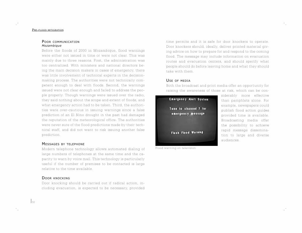
Flood warning on television
50
POOR COMMUNICATION
Mozambique
Before the floods of 2000 in Mozambique, flood warnings
were either not issued in time or were not clear. This was
mainly due to three reasons. First, the administration was
too centralized. With ministers and national directors be-
ing the main decision makers in cases of emergency, there
was little involvement of technical experts in the decision-
making process. The authorities were not technically com-
petent enough to deal with floods. Second, the warnings
issued were not clear enough and failed to address the peo-
ple properly. Though warnings were issued over the radio,
they said nothing about the scope and extent of floods, and
what emergency action had to be taken. Third, the authori-
ties were over-cautious in issuing warnings since a false
prediction of an El Nino drought in the past had damaged
the reputation of the meteorological office. The authorities
were never sure of the flood predictions made by their tech-
nical staff, and did not want to risk issuing another false
prediction.
MESSAGES BY TELEPHONE
Modern telephone technology allows automated dialing of
large numbers of telephones at the same time and the ca-
pacity to warn by voice mail. This technology is particularly
useful if the number of premises to be contacted is large
relative to the time available.
DOOR KNOCKING
Door knocking should be carried out if radical action, in-
cluding evacuation, is expected to be necessary, provided
time permits and it is safe for door knockers to operate.
Door knockers should, ideally, deliver printed material giv-
ing advice on how to prepare for and respond to the coming
flood. The message may include information on evacuation
routes and evacuation centers, and should specify what
people should do before leaving home and what they should
take with them.
USE OF MEDIA
Both the broadcast and print media offer an opportunity for
raising the awareness of those at risk, which can be con-
siderably more effective
than pamphlets alone. For
example, newspapers could
publish flood action guides
provided time is available.
Broadcasting media offer
the possibility to achieve
rapid message dissemina-
tion to large and diverse
audiences.
PRE-FLOOD MITIGRATION
51
SHELTERS
WHAT TO BRING TO A SHELTER
Monroe County in the United States has made a list of what each per-
son must bring to a shelter when a hurricane is predicted. Although
hurricanes do not pose the same threat as floods, the measures that
should be taken are more or less the same. That is why the following
list can be used for flood shelters as well:
- Water – one gallon per person per day;
- Food – high-energy food is preferable – must be non perishable,
needing little or no cooking. If required, people must also bring
their special dietary foods;
- Eating and drinking utensils are very useful, as well as ice for
cooling;
- One complete change of clothing;
- A sleeping bag, blanket and pillow;
- Rain gear and sturdy shoes;
- Personal items – a washcloth, towel, soap, toothpaste, tampons
etc;
- Medication – clearly marked with a name, dosage, type of
medication and the prescribing physician;
- A first-aid kit in a waterproof box. If needed, baby supplies must
be brought, such as diapers, formula, food etc;
- Identification and other valuable papers. People also need to bring
names and addresses of doctors and nearest relative not living in
the area; and
- Various other items are also useful – games, cards and toys, radios,
flashlights and batteries. People are advised to take a bath and eat
before they leave their homes.
(Source: http://www.co.monroe.fl.us)
CHURCHES AS EMERGENCY SHELTERS
Texas, USA
During the tropical storm Allison in 2001, churches in
Louisiana offered shelter to flood victims. In Houston, two
churches became emergency shelters to not only some of
the city ’s hurricane victims but also to those from south-
eastern Texas.
LOCAL INITIATIVES FOR SHELTERS
The Netherlands
In 1995, water levels in the Rhine and Meuse rivers rose
alarmingly. There was a real, imminent threat that dikes
along the rivers would collapse. This lead to the evacuation
of about 200,000 people from the risk areas who were then
accommodated in places such as churches, holiday parks
and camping sites.
CONSTRUCTION OF FLOOD SHELTERS
Assam, India
Following heavy rains in 2004 in the state of Assam, it was
decided that four large flood shelters should be constructed
for future emergencies. The shelters are to be single-sto-
ried, two-room structures raised on stilts so as to keep them
above the maximum flood level. Depending upon the sit-
uation, the shelters could be used as schools, community
centers, festival halls, meeting halls etc. Disaster mitigation
task-force meetings could also be held at these shelters and
disaster management training equipment and materials
could be stored as well.
PRE-FLOOD MITIGRATION
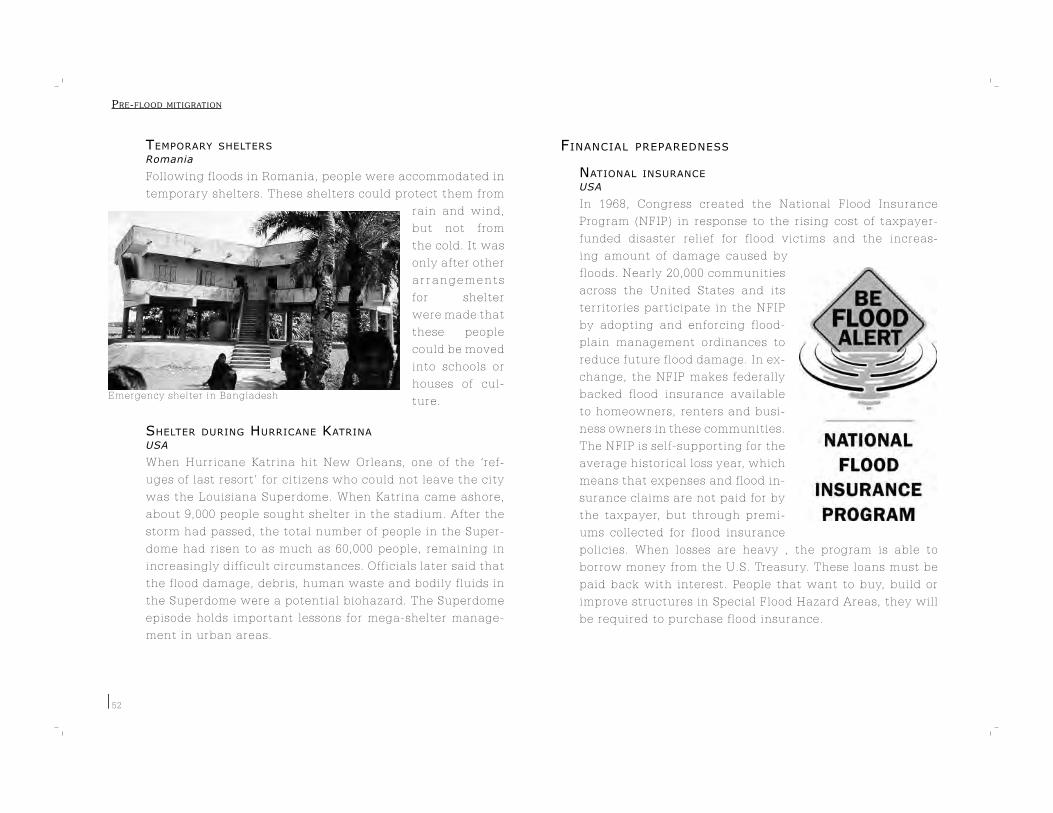
Emergency shelter in Bangladesh
52
TEMPORARY SHELTERS
Romania
Following floods in Romania, people were accommodated in
temporary shelters. These shelters could protect them from
rain and wind,
but not from
the cold. It was
only after other
a r r a n g e m e n t s
for shelter
were made that
these people
could be moved
into schools or
houses of cul-
ture.
SHELTER DURING HURRICANE KATRINA
USA
When Hurricane Katrina hit New Orleans, one of the ‘ref-
uges of last resort’ for citizens who could not leave the city
was the Louisiana Superdome. When Katrina came ashore,
about 9,000 people sought shelter in the stadium. After the
storm had passed, the total number of people in the Super-
dome had risen to as much as 60,000 people, remaining in
increasingly difficult circumstances. Officials later said that
the flood damage, debris, human waste and bodily fluids in
the Superdome were a potential biohazard. The Superdome
episode holds important lessons for mega-shelter manage-
ment in urban areas.
FINANCIAL PREPAREDNESS
NATIONAL INSURANCE
USA
In 1968, Congress created the National Flood Insurance
Program (NFIP) in response to the rising cost of taxpayer-
funded disaster relief for flood victims and the increas-
ing amount of damage caused by
floods. Nearly 20,000 communities
across the United States and its
territories participate in the NFIP
by adopting and enforcing flood-
plain management ordinances to
reduce future flood damage. In ex-
change, the NFIP makes federally
backed flood insurance available
to homeowners, renters and busi-
ness owners in these communities.
The NFIP is self-supporting for the
average historical loss year, which
means that expenses and flood in-
surance claims are not paid for by
the taxpayer, but through premi-
ums collected for flood insurance
policies. When losses are heavy , the program is able to
borrow money from the U.S. Treasury. These loans must be
paid back with interest. People that want to buy, build or
improve structures in Special Flood Hazard Areas, they will
be required to purchase flood insurance.
PRE-FLOOD MITIGRATION
53
Germany
In order to have a logical and fair basis for claiming flood
insurance, a zoning system has been developed in Germany
that specifies the threat different areas in the country face
from floods. Data regarding discharge velocities of water (in
case of flooding) was used to compute corresponding water
levels at any given point along chosen water courses. Then,
based on these computations, each area was allocated to
one of four flood risk categories based on the risk assess-
ment for that area.
MANDATORY NATURAL DISASTER INSURANCE
France
France has a functional system of insurance protection
against natural disasters. Under the system, it is mandatory
for citizens to purchase insurance against natural disaster
damage together with standard property insurance. The re-
insurance on risks is provided by financial institutions with
governmental warranty. In order to make use of the insur-
ance, the state must officially declare that there has been
a disaster.
SPECIAL FUND FOR NATURAL DISASTERS
European Union
Following the 2002 floods in central Europe, the European
Union set up the European Union Solidarity Fund (EUSF) as
a financial instrument to disburse rapid financial assistance
to victims in the event of a major disaster. The Fund will
help affected areas/communities return to living conditions
and willbe used only for emergency operations. The EUSF
was not set up to cover all the costs linked to natural dis-
asters nor was it meant to compensate for private losses or
damage covered by insurance.
PRE-FLOOD MITIGRATION

54
PRE-FLOOD MITIGRATION
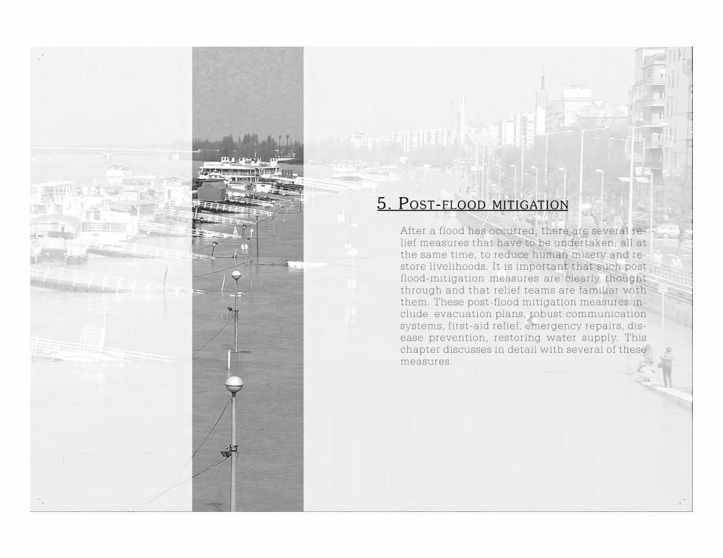
5. POST-FLOOD MITIGATION
After a flood has occurred, there are several re-lief measures that have to be undertaken, all at the same time, to reduce human misery and re-store livelihoods. It is important that such post flood-mitigation measures are clearly thought through and that relief teams are familiar with them. These post-flood mitigation measures in-clude evacuation plans, robust communication systems, first-aid relief, emergency repairs, dis-ease prevention, restoring water supply. This chapter discusses in detail with several of these measures.
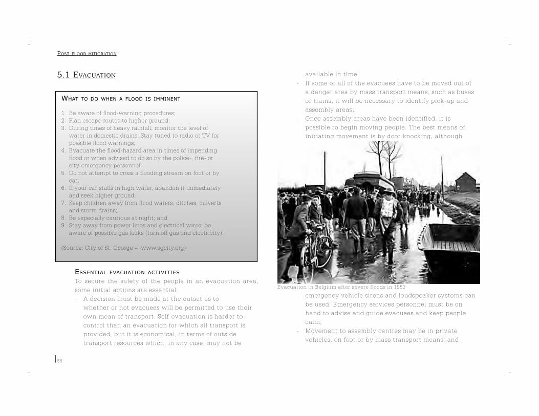
Evacuation in Belgium after severe floods in 1953
56
5.1 EVACUATION
WHAT TO DO WHEN A FLOOD IS IMMINENT
1. Be aware of flood-warning procedures;
2. Plan escape routes to higher ground;
3. During times of heavy rainfall, monitor the level of
water in domestic drains. Stay tuned to radio or TV for
possible flood warnings;
4. Evacuate the flood-hazard area in times of impending
flood or when advised to do so by the police-, fire- or
city-emergency personnel;
5. Do not attempt to cross a flooding stream on foot or by
car;
6. If your car stalls in high water, abandon it immediately
and seek higher ground;
7. Keep children away from flood waters, ditches, culverts
and storm drains;
8. Be especially cautious at night; and
9. Stay away from power lines and electrical wires; be
aware of possible gas leaks (turn off gas and electricity).
(Source: City of St. George – www.sgcity.org)
ESSENTIAL EVACUATION ACTIVITIES
To secure the safety of the people in an evacuation area,
some initial actions are essential:
- A decision must be made at the outset as to
whether or not evacuees will be permitted to use their
own mean of transport. Self-evacuation is harder to
control than an evacuation for which all transport is
provided, but it is economical, in terms of outside
transport resources which, in any case, may not be
available in time;
- If some or all of the evacuees have to be moved out of
a danger area by mass transport means, such as buses
or trains, it will be necessary to identify pick-up and
assembly areas;
- Once assembly areas have been identified, it is
possible to begin moving people. The best means of
initiating movement is by door knocking, although
emergency vehicle sirens and loudspeaker systems can
be used. Emergency services personnel must be on
hand to advise and guide evacuees and keep people
calm;
- Movement to assembly centres may be in private
vehicles, on foot or by mass transport means; and
POST-FLOOD MITIGRATION

Hurricane Katrina survivors evacuate on a school bus
Registration of displaced persons af-ter the tsunami of 2004
57
- Almost always, there will be those who will refuse to
leave, so areas which have been evacuated must
be checked. It is wise to arrange for police assistance to
be on hand for this purpose.
MOTORWAY LANE REVERSAL
USA
On some freeways in the USA, traffic direction can be re-
versed. This way, both lanes of the motorway can be used
during a large-scale evacuation. However, a drawback of
this system became
apparent when
it was applied in
Louisiana State
during Hurricane
Ivan – bottlenecks
developed at the
end of the motor-
way where all the
lanes converged.
CONTROLLED EVACUATION
Traffic congestion is a major problem during large-scale
evacuations because of the limited capacity of roads. To
prevent congestion, it is useful to evacuate the various ar-
eas of a city in different stages and directions. This way,
the entire traffic is manageably spread out over time and in
different directions.
EVACUEE REGISTRATION
When arriving at evacuation or registration centres (or hos-
pitals in the case of casual-
ties), evacuees must be reg-
istered as soon as possible.
If registration is not accom-
plished quickly, victims will
drift away. Countries should
have a standard format for
registering evacuees. If this
is not available, then these
are the details that should
be recorded:
- Surname and initials;
- Date of birth;
- Home address;
- Destination;
- Contact phone number;
- Permission to release information.
USING BOATS FOR EVACUATION
India
Transport is a critical problem during floods. To reach ma-
rooned people, boats are essential – but they are rarely
available in sufficient numbers. Therefore, villagers can
pitch in efforts and resources to construct boats if they have
advance warning of impending floods. A number of local
techniques have been developed to make boats from locally
available material. These include:
1. Cot boats – cots are converted into boats for moving
light materials.
2. ‘Karahi’ boats – large pots (or karahis) are used for
mobility during floods.
POST-FLOOD MITIGRATION
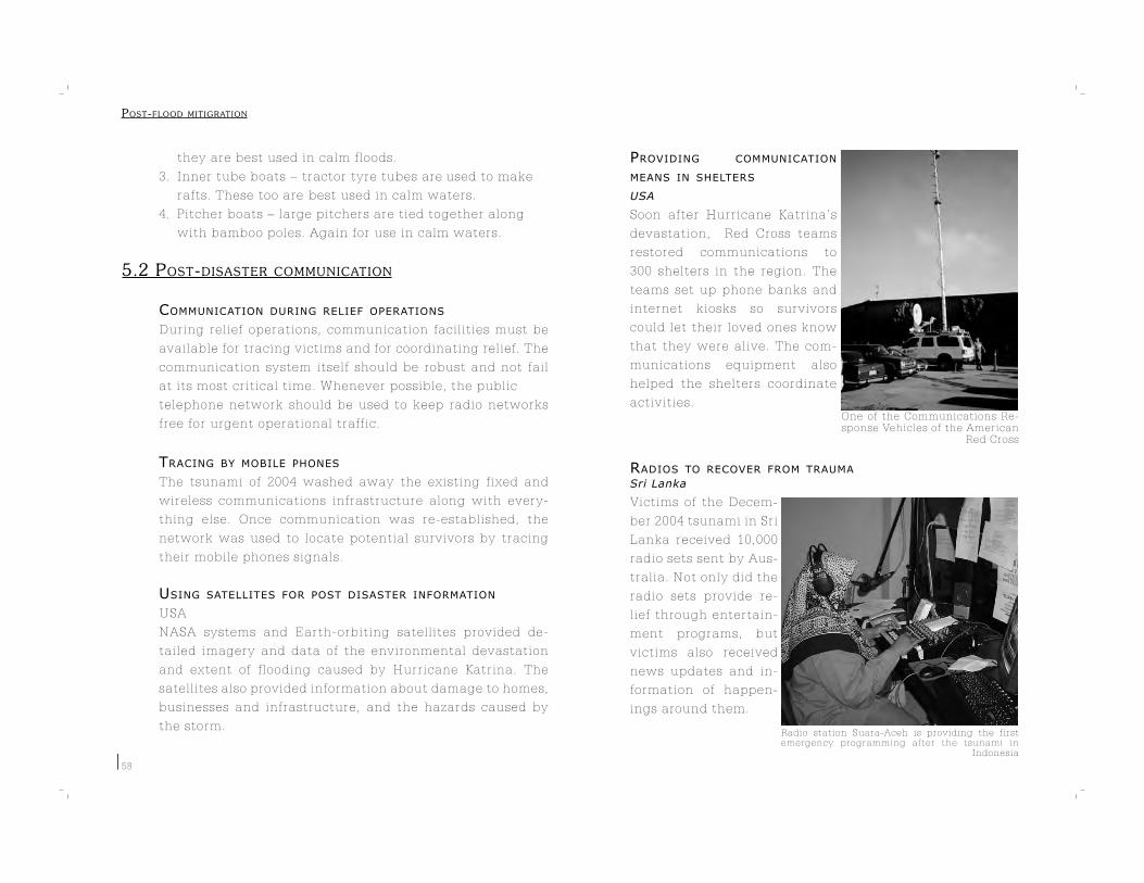
One of the Communications Re-sponse Vehicles of the American
Red Cross
Radio station Suara-Aceh is providing the first emergency programming after the tsunami in
Indonesia
58
they are best used in calm floods.
3. Inner tube boats – tractor tyre tubes are used to make
rafts. These too are best used in calm waters.
4. Pitcher boats – large pitchers are tied together along
with bamboo poles. Again for use in calm waters.
5.2 POST-DISASTER COMMUNICATION
COMMUNICATION DURING RELIEF OPERATIONS
During relief operations, communication facilities must be
available for tracing victims and for coordinating relief. The
communication system itself should be robust and not fail
at its most critical time. Whenever possible, the public
telephone network should be used to keep radio networks
free for urgent operational traffic.
TRACING BY MOBILE PHONES
The tsunami of 2004 washed away the existing fixed and
wireless communications infrastructure along with every-
thing else. Once communication was re-established, the
network was used to locate potential survivors by tracing
their mobile phones signals.
USING SATELLITES FOR POST DISASTER INFORMATION
USA
NASA systems and Earth-orbiting satellites provided de-
tailed imagery and data of the environmental devastation
and extent of flooding caused by Hurricane Katrina. The
satellites also provided information about damage to homes,
businesses and infrastructure, and the hazards caused by
the storm.
PROVIDING COMMUNICATION
MEANS IN SHELTERS
USA
Soon after Hurricane Katrina’s
devastation, Red Cross teams
restored communications to
300 shelters in the region. The
teams set up phone banks and
internet kiosks so survivors
could let their loved ones know
that they were alive. The com-
munications equipment also
helped the shelters coordinate
activities.
RADIOS TO RECOVER FROM TRAUMA
Sri Lanka
Victims of the Decem-
ber 2004 tsunami in Sri
Lanka received 10,000
radio sets sent by Aus-
tralia. Not only did the
radio sets provide re-
lief through entertain-
ment programs, but
victims also received
news updates and in-
formation of happen-
ings around them.
POST-FLOOD MITIGRATION

Distribution of clothes and food in India
59
5.3 EMERGENCY RELIEF
DIRECT RELIEF AFTER A FLOOD
After providing emergency relief, it is important to under-
take post-disaster relief activities to quickly restart the lo-
cal economy and resume basic social services. This means
that clean water, or means to obtain clean the water, must
be provided. In addition, food, medical sets and sanitation
material have to be supplied. Following this, shelter and
clothing must be provided to prevent post-flood casualties.
Examples of indirect needs include providing farmers with
seeds and fertilizers, and constructing schools for educa-
tional needs.
DEPLOYING BOATS AND HELICOPTERS
Mozambique
After the floods of 2000 in Mozambique, many countries
came forward to assist in the rescue of as many people as
possible. The military was sent out into the countryside on
aeroplanes, helicopters and boats to retrieve people from
flooded areas. The boats proved to be very useful in reach-
ing isolated communities that required aid.
USING EXISTING CHANNELS
Bangladesh
In the aftermath of
floods in Bangladesh,
agricultural service pro-
viders were engaged to
implement the govern-
ment-led agricultural
rehabilitation program. The service providers collected
seeds from the government and distributed them amongst
poor farmers.
REPLACEMENT SEEDS
Somalia
In 1997, torrential rains flooded many of the traditional un-
derground storage pits (bakars) which Somalis use to pre-
serve their grains and seeds. After sending emergency relief
to the flood victims, the International Committee of the Red
Cross decided to provide farmers with replacement seeds
which could be planted in time for the sowing season. Since
there was also a direct food shortage, steps had to be taken
to avoid the immediate consumption of the seeds. There-
fore, each family was also given 45 kilograms of food in ad-
dition to a vegetable seed kit.
ENSURING BASIC FOOD QUALITY STANDARDS
Food distribution should be done under extremely sanitary
conditions to prevent spread of infection and disease. Food
quality must be ensured before distribution and all food do-
nations must be accepted by the distribution committee to
prevent unauthorized food distributions.
DEPLOYING BOATS AND HELICOPTERS
Mozambique
After the floods of 2000 in Mozambique, many countries
came forward to assist in the rescue of as many people as
possible. The military was sent out into the countryside on
aeroplanes, helicopters and boats to retrieve people from
flooded areas. The boats proved to be very useful in reach-
POST-FLOOD MITIGRATION

Evacuation using boats after the floods of 1953 in The Netherlands
60
ing isolated communities that re-
quired aid.
DIRECT RELIEF AFTER A FLOOD
After providing emergency relief,
it is important to undertake post-
disaster relief activities to quick-
ly restart the local economy and
resume basic social services. This
means that clean water, or means
to obtain clean the water, must
be provided. In addition, food, medical sets and sanitation
material have to be supplied. Following this, shelter and
clothing must be provided to prevent post-flood casualties.
Examples of indirect needs include providing farmers with
seeds and fertilizers, and constructing schools for educa-
tional needs.
DRINKING WATER QUALITY
METHODS TO CLEAN WATER
Pollution of drinking water is always a major problem in
flooded areas. Shallow wells are immediately contaminat-
ed, hand pumps get submerged and the flood water itself
is highly polluted. In such a scenario, clean water can be
obtained by following the following common practices:
1. Boiling water;
2. Cleaning/purifying water with alum;
3. Cleaning/purifying water with bleaching powder;
4. Raising the height of hand pumps; and
5. Filtering water.
TESTING KIT
Sri Lanka
The Industrial Technology Institute tested drinking water
in densely populated areas that were hit by the tsunami
in Sri Lanka. The Institute used a testing kit that provided
results very quickly.
WATER-PURIFYING PACKAGE
Tsunami-hit areas
Greenstar Social Marketing in Pakistan had a stock of nine
million packets of PUR Purifier of Water donated by Proc-
tor & Gamble – enough stock to sanitize 90 million litres of
water. The Greenstar staff worked with local government
agencies to organize the logistics of moving 8.8 millions sa-
chets to needy regions. PUR sachets were shipped by the
International Federation of the Red Cross from Greenstar
warehouses in Pakistan to Indonesia, Sri Lanka and other
aid organizations. PUR was given free to survivors.
EDUCATION ON SAFE WATER AFTER EMERGENCY
India
Population Services International (PSI), an Indian non-profit
organization, made staff available in tsunami-hit areas to
train and educate affected populations about the impor-
tance of treating water before consumption and use. The
idea was to avoid the spread of water-borne diseases and
support oral-rehydration therapy initiatives being under-
taken to treat diarrhoea-induced dehydration.
SOLAR WATER DISINFECTION
Solar Water Disinfection (SODIS) is a simple method that
POST-FLOOD MITIGRATION

A pump draws contaminated water from a fresh-water well in Sri Lanka
Water quality is improved with solar radiation
Cleaning water with a low cost ceramic filter
61
uses solar radiation to improve the microbiologi-
cal quality of drinking water. A study showed
that regular consumption of SODIS-treated
water has a significant impact on health –
cases of diarrhoea in children that con-
sumed the water were 35% less.
CERAMIC FILTERS
The Silver Ceramic System (SCS)
pottery pu-
rifier offers
an easy, inex-
pensive way of purifying wa-
ter. The ceramic filter is made of
a mixture of clay and sawdust,
which is heated and then treated
with colloidal silver. The SCS re-
moves both impure particles and
bacteria.
DESALINATION OF WATER WELLS
South East Asia
The tsunami of December 2004
submerged coastal areas under several meters of sea water
for many hours. This caused salt water to seap into underly-
ing fresh-water aquifers, resulting in the contamination of
water wells used by people in several areas. There are ways
to rectify such a situation. The first approach, though a pas-
sive one, is to let the aquifer naturally flush out the saline
water as it would do in the normal course. This however
requires a long recovery time and alternative drinking wa-
ter arrangements
must be made in
the meantime.
The second op-
tion is well-purg-
ing. Salt water is
removed imme-
diately by pump-
ing the well for a
period of time un-
til saline concen-
tration becomes
negligible. The
final option is to limit the contamination to shallow aqui-
fers. Confining units are used to isolate deep aquifers from
shallow contaminated ones, thereby ensuring good water
quality in the former.
DISEASE PREVENTION
PREVENTING DISEASES FROM SPREADING
The WHO has drawn up the following list of immediate
measures that need to be taken after a flood to prevent
communicable diseases:
1. Emergency medical care – providing medical and
surgical care and psychosocial support is a first priority;
2. Water and sanitation – to prevent water-borne diseases,
provision of safe drinking water is necessary.
Chlorine can be provided to disinfect water. Also,
adequate sanitation must be provided in the form of
latrines or designated defecation areas;
POST-FLOOD MITIGRATION

62
3. Provision of clean food;
4. Site planning and shelter – shelters must be placed with
sufficient space in between them to prevent
overcrowding;
5. Immunization – people must be vaccinated as soon as
possible (e.g. to prevent measles); but mass vaccination
is not recommended for all diseases;
6. Establish a surveillance system – a system must be
setup to support early detection of outbreak-prone
diseases;
7. Vector control – actions must be taken to decrease the
chance of infection. These include spraying shelters
with insecticides, covering water-storage containers
and collecting and clearing garbage;
8. Health Education and social mobilization – good
hygiene practice must be promoted. People must learn
how to prepare safe food and cook or chlorinate water.
Also, early detection and treatment of fever is of vital
importance; and
9. Disposal of human remains – human remains do not
pose a risk of epidemics after natural disasters, but
people should be informed to avoid panic and
inappropriate disposal of bodies. Also, contact with
blood and body fluids must be prevented.
MANAGING HEALTH CARE IN FLOOD SHELTERS
CARE has come up with a checklist of activities that need to be consid-
ered while providing health services to disaster victims in flood shel-
ters:
- Meet community leaders and discuss plans;
- Check general ration supply;
- Ensure appropriate, adequate and un-crowded shelters;
- Discuss sanitation with the community;
- Protect the water supply from pollution;
- Integrate nutrition screening, Vitamin A/Measles/Polio
vaccination for children below recommended age;
- Set up supplementary, intensive feeding for
undernourished children and lactating, pregnant
mothers;
- Assess major current disease problems;
- Plan for message dissemination on health and hygiene
among the camp population and seek voluntary support
from the camp community; and
- Set up an integrated clinic and health-scout program to
provide curative services for major diseases.
(Source: Asian Disaster Preparedness Center – http://www.adpc.net/
infores/newsletter/2000/grass-2.html)
DISEASE TRACKING
Aceh, Indonesia
The setting up of a disease-tracking/disease-surveillance
system on the ground by the WHO and the Indonesian
health authorities helped prevent any major disease out-
break following the 2004 tsunami. The Outbreak & Alert Re-
sponse Team would get messages via telephone, SMS or fax
from distant areas about possibly infected patients. Team
members would then quickly reach the location and collect
patient samples that were immediately analyzed. Based on
POST-FLOOD MITIGRATION

Medical care is provided on the scene in India after the tsunami
Contents of a ‘School-in-a-Box’ kit
63
the analysis, remedial actions were
then taken – which meant either
treating the patient or vaccinating
the population in the vicinity to pre-
vent the spread of the disease.
POST-DISASTER HEALTH STRATEGY
CARE Bangladesh advises that a pub-
lic health physician should supervise
the overall activity of a camp health
centre. Similarly, a logistics manager
should be responsible for support to
all centre personnel. In addition, two
or three paramedics should be em-
ployed to help with clinical services.
Critical or complicated patients should be referred to the
supervising physician for further evaluation.
TRAUMA CARE
Disasters cause major environmental, societal and personal
disturbances. When these disturbances are not treated, pa-
tients may develop trauma. That is why, during and after a
disaster, people need to be assessed on their psychological
status. Next to the victims, relief workers should also be
assessed, as well as the assessors themselves – as their as-
sessments may be distorted in traumatic situations.
USE OF VOLUNTEERS
Volunteers should be appointed in health camps to ob-
tain information about outbreaks of diseases and to pro-
vide health information to those around them. To prevent
negative impacts in the camp, complicated cases should be
treated outside. It is best to establish referral linkages with
local clinics and hospitals so that complicated cases that
need hospital care can be sent there. Only common cases
treatable with drugs and minor injuries should be treated
at the camp health centre itself.
CHILD CARE
SCHOOLS IN A BOX
USA
In response to Hurricane Katrina, UNICEF has set up schools
in camps where people displaced by the disaster have been
living.
The so-called ‘School-in-a-Box’ kit contains supplies for one
teacher and up to 40 students. It contains books, pencils,
erasers, scissors, a teaching clock, plastic cubes for count-
ing and a set of laminated posters. Teachers can establish
makeshift classrooms by
using a locally developed
teaching guide and cur-
riculum .
In addition, UNICEF is
also providing children
with a recreation kit that
includes balls, coloured
tunics, chalk, a measuring
tape for marking play ar-
eas, a whistle and a scor-
ing slate.
POST-FLOOD MITIGRATION

Cement brick house with a raised plinth height
64
SUGGESTIONS FOR CHILD CARE
Plan USA, an organization working for children’s welfare,
has developed some practical rules to ensure the rehabilita-
tion of children in disaster-struck areas:
- Children in potential disaster areas must know where
to go in case of an emergency. This information has to
be provided in recognizable and clear ways;
- Communities must develop contingency plans and
children must be involved in this process;
- Aid organizations must train their employees in child
protection, child healthcare and child participation;
- Protection of children must be guaranteed not only
directly after a disaster, but also on a longer term.
Nurseries and day-care centres may contribute to this;
- Teachers, physicians, and relief workers must be
trained to recognize symptoms of psychological trauma
in children;
- Children can contribute to the rehabilitation by
assisting other children who are alone by sharing food
and water or by helping with recreational activities;
- Schools offer a stable and safe environment that can be
used for trauma handling. Daily routine will bring peace
into the lives of children; and
- Children must be taken care of in their own community
as much as possible.
REBUILDING SCHOOLS TO ENSURE STABILITY
Tsunami-hit areas
For children it is very important that they can go back to
school. This way children are provided with a daily struc-
ture and a safe environment to live in.
5.4 RESTORING LIVELIHOODS
FINANCIAL ASSISTANCE
LOANS FOR ENTREPRENEURS
Poland
In Poland, subsidized loans were offered to groups of
affected micro-entrepreneurs who were struck by floods in
1997. The loans were offered for a term of 24 months at an
interest rate three times lower than the average rate in the
country. For a majority of the borrowers, the disaster loan
was the only disaster assistance that they received.
LOW INTEREST HOUSING LOAN
Bangladesh
The Bank of
Bangladesh has
provided loans
through micro-
finance institu-
tions in Bangla-
desh. The bank
provided 10-
year term home
c o n s t r u c t i o n
loans, to build
f l ood- res i s tant
homes using cement and tin, at an annual interest rate of
1%.
POST-FLOOD MITIGRATION
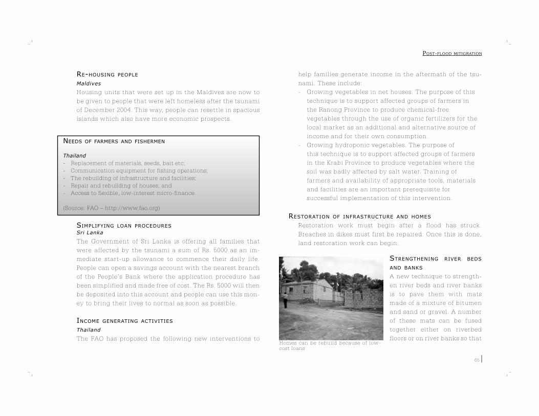
Homes can be rebuild because of low-cost loans
65
RE-HOUSING PEOPLE
Maldives
Housing units that were set up in the Maldives are now to
be given to people that were left homeless after the tsunami
of December 2004. This way, people can resettle in spacious
islands which also have more economic prospects.
NEEDS OF FARMERS AND FISHERMEN
Thailand
- Replacement of materials, seeds, bait etc;
- Communication equipment for fishing operations;
- The rebuilding of infrastructure and facilities;
- Repair and rebuilding of houses; and
- Access to flexible, low-interest micro-finance.
(Source: FAO – http://www.fao.org)
SIMPLIFYING LOAN PROCEDURES
Sri Lanka
The Government of Sri Lanka is offering all families that
were affected by the tsunami a sum of Rs. 5000 as an im-
mediate start-up allowance to commence their daily life.
People can open a savings account with the nearest branch
of the People’s Bank where the application procedure has
been simplified and made free of cost. The Rs. 5000 will then
be deposited into this account and people can use this mon-
ey to bring their lives to normal as soon as possible.
INCOME GENERATING ACTIVITIES
Thailand
The FAO has proposed the following new interventions to
help families generate income in the aftermath of the tsu-
nami. These include:
- Growing vegetables in net houses. The purpose of this
technique is to support affected groups of farmers in
the Ranong Province to produce chemical-free
vegetables through the use of organic fertilizers for the
local market as an additional and alternative source of
income and for their own consumption.
- Growing hydroponic vegetables. The purpose of
this technique is to support affected groups of farmers
in the Krabi Province to produce vegetables where the
soil was badly affected by salt water. Training of
farmers and availability of appropriate tools, materials
and facilities are an important prerequisite for
successful implementation of this intervention.
RESTORATION OF INFRASTRUCTURE AND HOMES
Restoration work must begin after a flood has struck.
Breaches in dikes must first be repaired. Once this is done,
land restoration work can begin.
STRENGTHENING RIVER BEDS
AND BANKS
A new technique to strength-
en river beds and river banks
is to pave them with mats
made of a mixture of bitumen
and sand or gravel. A number
of these mats can be fused
together either on riverbed
floors or on river banks so that
POST-FLOOD MITIGRATION
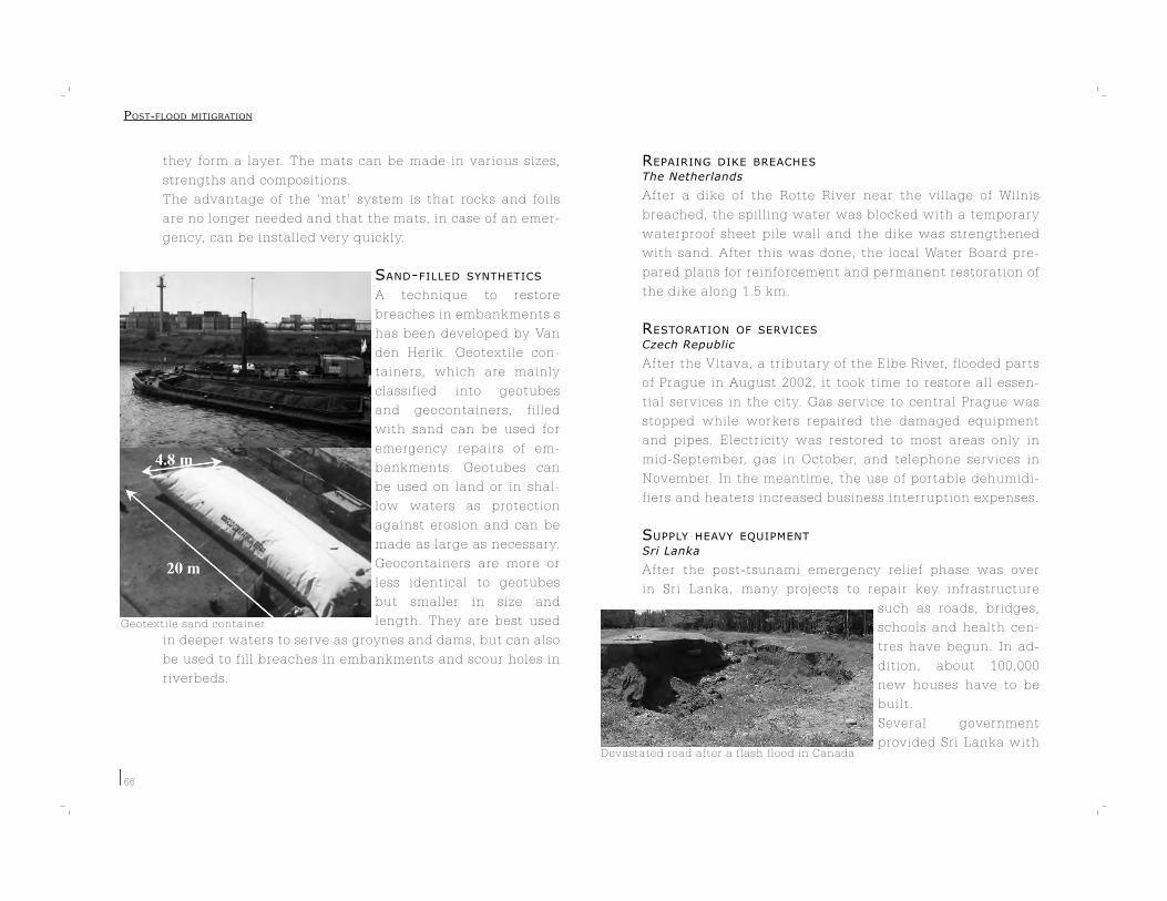
Geotextile sand container
Devastated road after a flash flood in Canada
66
they form a layer. The mats can be made in various sizes,
strengths and compositions.
The advantage of the ‘mat’ system is that rocks and foils
are no longer needed and that the mats, in case of an emer-
gency, can be installed very quickly.
SAND-FILLED SYNTHETICS
A technique to restore
breaches in embankments s
has been developed by Van
den Herik. Geotextile con-
tainers, which are mainly
classified into geotubes
and geocontainers, filled
with sand can be used for
emergency repairs of em-
bankments. Geotubes can
be used on land or in shal-
low waters as protection
against erosion and can be
made as large as necessary.
Geocontainers are more or
less identical to geotubes
but smaller in size and
length. They are best used
in deeper waters to serve as groynes and dams, but can also
be used to fill breaches in embankments and scour holes in
riverbeds.
REPAIRING DIKE BREACHES
The Netherlands
After a dike of the Rotte River near the village of Wilnis
breached, the spilling water was blocked with a temporary
waterproof sheet pile wall and the dike was strengthened
with sand. After this was done, the local Water Board pre-
pared plans for reinforcement and permanent restoration of
the dike along 1.5 km.
RESTORATION OF SERVICES
Czech Republic
After the Vltava, a tributary of the Elbe River, flooded parts
of Prague in August 2002, it took time to restore all essen-
tial services in the city. Gas service to central Prague was
stopped while workers repaired the damaged equipment
and pipes. Electricity was restored to most areas only in
mid-September, gas in October, and telephone services in
November. In the meantime, the use of portable dehumidi-
fiers and heaters increased business interruption expenses.
SUPPLY HEAVY EQUIPMENT
Sri Lanka
After the post-tsunami emergency relief phase was over
in Sri Lanka, many projects to repair key infrastructure
such as roads, bridges,
schools and health cen-
tres have begun. In ad-
dition, about 100,000
new houses have to be
built.
Several government
provided Sri Lanka with
POST-FLOOD MITIGRATION
67
heavy machinery and equipment to rebuild the country,
apart from financial aid.
REBUILDING BETTER HOUSES
Sri Lanka
In several rebuilding programs in Sri Lanka, affected fami-
lies are being involved in the rehabilitation process to take
their preferences into account. The houses being built will
be child friendly and communities are being provided with
all necessities such as drinking-water systems, sanitary fit-
tings and shops.
APPROPRIATE HOUSING TECHNIQUES
Mozambique
The floods of 2000 showed that houses built of reed were
not strong enough to withstand the force of flowing waters
and were hence washed away. On the other hand, wattle
and daub houses with corrugated steel roofing sheets sur-
vived the onslaught. Therefore, as part of the post-flood re-
habilitation program, people who had lost their homes were
provided with the material and funds required to build rela-
tively stronger houses.
POST-FLOOD MITIGRATION

68
POST-FLOOD MITIGRATION

6. BENEFITS OF FLOODWATERS AND FLOODPLAINS
Though floods are often associated with dam-age and misery, they also have several benefi-cial uses. In some of the poorest parts of the world, floodwater is often used for irrigation while in other areas, temporarily flooded land is utilized for cultivation. Generally speaking, floodplains represent important production sys-tems. Floods sustain fisheries and many native plant species. In Europe, North America and elsewhere, there are many instances where floodwater is being used for groundwater re-charge. Furthermore, the floodplains tradition-ally mark migration routes for many wetland bird species. These birds rely on the presence of regular stopover sites in which they can rest and refuel. This chapter discusses several such examples. There are many positive aspects to floods and floodplains which need to be incor-porated into area planning and flood manage-ment.

Semi traditional irrigation structure Yemen
Controled flood release
70
6.1 USING FLOODWATER FOR IRRIGATION
SPATE-WATER IRRIGATION
In many arid or semi-arid regions, spate irrigation is used
to supply agricultural land with water. Spate irrigation is a
type of river management where floodwater is diverted from
normally dry river
beds (when flood-
waters overflow)
to agricultural
lands by the use
of spurs or bunds
and flow channels.
Spate systems are
very risk-prone
because of the
unpredictable na-
ture of floods and
the frequent changes in the river beds, which occurs due to
sediment shifts, from which the water is diverted. Normally,
spate systems are designed to keep away very high floods
from irrigation areas. If not, heavy floodwaters would not
only damage lands and flood diversion channels, but also
cause rivers to shift. That is why the main diversion struc-
tures in traditional spate systems, like spurs and bunds, are
designed to break when the floods are too big. This way, the
vulnerable diversion system is protected and land owners
downstream maintain their floodwater entitlements.
ARTIFICIAL FLOOD RELEASES
Senegal
The construction of the Manantali Dam in Senegal, ac-
cording to an earlier design,
would have meant the end of
the natural seasonal inunda-
tion of the floodplains down-
stream. To overcome this
problem, even as the dam’s
construction was going on,
controlled flood releases
were made to serve 100,000
hectares of land dependent
on inundation for agricul-
ture, fishing and grazing.
The World Bank agreed to
help finance the dam’s com-
pletion in 2001 provided the
principle of ‘managed floods’
would be recognized as a
long-term strategy.
KENYA
To meet the increasing demand for electricity in Kenya,
there is a proposal underway to dam the Tana River. Since
the Tana has an extensive floodplain and delta that sup-
ports the livelihoods of over half a million people through
agriculture, fishing, livestock rearing and horticulture,
planners and developers have agreed that the floods that
used to take place seasonally must continue. As a result,
the dam is being designed to store enough water to produce
BENEFITS OF FLOODWATERS AND FLOODPLAINS
Floating village on the Ton Le Sap Lake
71
a flood downstream through short-term high-flow releases,
as well as produce the necessary hydro-electricity. Because
silt is recognized as very important, the designers will try to
release silt together with the floodwater.
FLOOD AGRICULTURE
Ton Le Sap Lake, Cambodia
The Ton Le Sap Lake in Cambodia is connected to the Mekong River
and acts as a retention area for the river during floods to reduce dam-
age downstream. Ever year, around May, water from the Mekong flows
into the lake and the water levels rise up to 9m. In October, the flow
reverses direction and flows out to the Mekong again. This variation
in water levels allows for an unusual recession cropping system. Dur-
ing the flood, water can be stored at the edge of the floodplain. After
the floodwater has receded, rice cultivation starts. The stored water
can then be used to irrigate the land that is uncovered by the receding
flood. The filling of the storage and the actual irrigation can often be
achieved by gravity alone, without the need of a pump.
(Source: Masumoto, T. et al., Future basin-wide flood management by
using the roles of paddies in Monsoon Asia)
FLOODPLAIN AGRICULTURE
Australia
Floodplains are generally the more fertile agricultural areas
in Australia. A significant proportion of Australia’s agricul-
tural output is produced on floodplains, which are hubs for
extensive and intensive agriculture, including irrigated ag-
riculture. Regular flooding of these areas improves soil fer-
tility and agriculture by increasing soil moisture, recharg-
ing groundwater tables and depositing fertile silt.
MULTIFUNCTIONAL PADDIES
Mekong River Delta
In the Mekong River Delta, paddy fields are used as reten-
tion basins when floods occur. The water that is stored in
these paddies acts as a nursery ground for fish cultivation
and/or allows fishermen to obtain fish for their own con-
sumption. This way, the paddy fields can be used for inte-
grated agri-/fish-farming and therefore bestow larger eco-
nomic benefit.
THE NILOMETER
Egypt
The ancient Egyptians are considered among the first peo-
ple to have recorded water levels of their river, the Nile.In
support of the flood based agriculture, the Egyptians used a
specially developed mechanism, the Nilometer, which was
a large stilling well with a marble octagonal column at its
center. The column was graded to measure water levels and
indicated the extent of the flooding of the Nile. Knowing
how high the Nile had risen was extremely important to
the survival of the Egyptians. A low flood could mean crop
failures, drought and famine and a high flood would destroy
BENEFITS OF FLOODWATERS AND FLOODPLAINS

Nilometer at Aswan, Egypt
Permeable rock dams with stone bunds can be used for floodwater harvesting and water spreading
72
all irrigation works and crops.
Because the ancient Egyptians
traded in crops, the Nilometer
was used to compute the levy
of taxes for the coming year.
FLOODWATER SPREADING FOR LAND MANAGEMENT
Iran
Floodwater spreading is a meth-
od of harnessing the rich sedi-
ments and nutrients present in
floodwaters for a number of important uses. These include:
- Meeting the water requirements of annual and
perennial crops and vegetation, either immediately or
over time by using surface reservoirs and aquifers;
- Recharging aquifers to prevent the intrusion of salt
water into water-bearing layers;
- Stabilization of drifting sands through precipitation of
the suspended load;
- Grading land on sloping and eroded surfaces;
- Reducing gully erosion and controlling downstream
flooding; and
- Leaching saline soils.
ADAPTING FARMING SYSTEMS
Vietnam
Farmers in Vietnam plant their crops early to avoid floods.
They have developed new techniques of shrimp and fish
breeding suitable for flooded areas. The shrimp and fish en-
ter the area during floods and are harvested with the rice.
Mekong delta
In the Mekong delta, people use floodwaters for paddy culti-
vation using a technique called ‘colmatage’. This technique
involves digging out natural levees that channel rising wa-
ter from the river to the areas behind the levees. A part of
the water stored this way remains in the area even after the
water levels in the river have decreased and is used for rice
production during the dry season.
6.2 FLOODS AND FISHERIES
FLOODPLAIN FISHERIES
When farmlands are flooded, normal agricultural activities
have to be stopped. At such times, farmers can switch to
fish cultivation using boats, nets and/or using fishing lines
in agricultural fields. The fish thus cultivated is not only a
BENEFITS OF FLOODWATERS AND FLOODPLAINS
Floodplains can be pumped dry to extract the last remaining fish
Several fish species require seasonal floods to breed
73
source of food for farmers but also a
major source of income.
IMPROVING FLOOD PLAIN FISHERIES Bangladesh
About 34 % of Bangladesh’s land area
is under water almost six months a
year providing an ideal, rich and nat-
ural setting for fish cultivation. Even
the cost of fish feed can be avoided as naturally growing
vegetation in the floodplains is a rich source of food for the
fish. However, in spite of this natural wealth, fish cultiva-
tion in the floodplains has been dropping for some years. In
order to turn the situation around, the government initiat-
ed the Third Fisheries Project, which has resulted in an in-
crease in fish and shrimp production for domestic consump-
tion and export. Production of stocked species increased by
700% while that of non-stocked species was either main-
tained or showed marginal increase. The Project has also re-
sulted in improved management of the floodplains through
private-sector and community participation.
MANAGED FLOODS AND FISH STOCK
USA
In 1996, a managed flood was conducted on the Colorado
River in Arizona which gave scientists a rare opportunity to
intensively study a strong flood. Follow-up research showed
that the flood increased sand bars and improved backwater
areas which provide important habitat for young fish. Ad-
ditionally, the managed flood cut down the number of non-
native fish.
SMALL PULSES OF FLOODWATER
In some ecosystems, water
needs to be present or absent
at the right times of the year.
Many organisms are adapt-
ed to expect a series of small
floods at the beginning of the
rainy season which signals to
them that it is time to breed,
before the bigger mid-season
floods arrive. Some species need small pulses of freshwater
to signal the start of migration and to provide direction.
PROVIDING DEBRIS FOR BREEDING
Many fish species depend on normal flooding to wash wood
debris into the water, which they then use for shelter.
6.3 USING FLOODWATERS FOR GROUNDWATER RECHARGE
AND WATER BUFFERS
GROUNDWATER RECHARGING
When floods occur, wetlands and floodplains can store wa-
ter. Slowing down the runoff allows additional time for the
water to infiltrate and recharge available groundwater aq-
uifers, when there is unused storage capacity.
USA
In the Mojave Desert, the only source of water is the Mojave
River. However, the river itself is unreliable for direct water
supply because its river bed is dry, except for a short period
of returning flow and periods of flow after intense storms.
BENEFITS OF FLOODWATERS AND FLOODPLAINS

Changing river landscape: The Rhine at 1838 and 1980. A clear change in river dynamics and floodplains
74
Therefore, the residents of the basin rely almost entirely on
ground water reserves, which are recharged by floods.
Nigeria
The population around the wetlands of the Hadejia-Jama’are
floodplain depend heavily on groundwater for drinking and
other household uses. The aquifer is recharged by the regu-
lar flooding of the wetlands.
USING WATER IN FLOODPLAINS AS DRINKING-WATER SOURC-ES
The Netherlands
To create new sources of drinking water, there are proposals
to create water-collection basins and infiltration facilities
in the floodplains of rivers. These proposals are part of the
government’s current strategy to process drinking water
from surface-water sources. This way the decline in ground-
water tables can be reduced.
CONTROLLING NEGATIVE EFFECTS OF SAND MINING
The capacity of a river to ‘store’ floods and recharge sur-
rounding aquifers is often negatively affected by sand
mining. Rather than being absorbed in the river bed, the
floods flow downstream. Controlling sand mining is impor-
tant to mitigate flood peaks and to improve groundwater
recharge.
BENEFITS OF FLOODWATERS AND FLOODPLAINS

ANNEX 1: REFERENCE SOURCES
This annex provides a list of reference sources including the names of organizations, a short description of their activities and their contact details. The organizations can be contacted ei-ther through their websites or with the help of contact details listed here. This annex has been compiled by the authors from searches made during the preparation of this book and does not pretend to be exhaustive. The references are arranged in alphabetical order under the following topics:1. Flood Management;2. Disaster Management and Relief;3. Trans-boundary Initiatives; and4. General Information Sources.
76
1. FLOOD MANAGEMENT
FLOOD ORGANIZATIONS
WMO, Associated Program on Flood Management (APFM)
The APFM is a joint initiative of the World Meteorologi-
cal Organization (WMO) and the Global Water Partnership
(GWP). It promotes the concept of Integrated Flood Man-
agement (IFM) as a new approach to managing floods. The
principal goal of the APFM is to maximize the productivity
of the floodplains while minimizing loss to life and property.
Thus, an increase in occasional losses from floods can be
consistent with a long-term increase in the efficient use of
flood-prone land.
E-mail: [email protected]
Internet: http://www.apfm.info
Global Water Partnership (GWP): Integrated Water Resourc-
es Management (IWRM) ToolBox
The GWP has developed a web-based ToolBox on IWRM. It
is a reference site that provides water management profes-
sionals with examples of good and bad practices and
lessons learnt from real-life experiences of implementing
IWRM. Information is
organized into four main parts – policy guidance; operation-
al tools; case studies and references; and organizations and
websites. The ToolBox would be useful to water-resource
management professionals such as water-resource plan-
ners, policy makers, river-basin managers and political ad-
visors, as well as the general public.
E-mail: [email protected]
Internet: www.gwpforum.org
International Flood Network (IFNet)
The objective of the IFNet is to facilitate international coop-
eration in flood management. The Network aims to reduce
the damage and loss to life caused by floods. It also intends
to promote policies and practices that can break the vicious
circle of poverty and environmental degradation thereby
leading to a safe and sustainable future. IFNet believes that
there must be a shift in emphasis from reactive to proactive
action by authorities and that flooding is often a very local
problem that can benefit from national and international
assistance. IFNet provides a framework within which all
those who work in flood management can exchange infor-
mation and seek partnerships to improve the effectiveness
of their work.
IF-net,
c/o Infrastructure Development Institute (IDI), 5-3-23, Koji-
machi, Chiyoda-ku, Tokyo, 102-0083, JAPAN
Fax: +81 3 3230 4030
E-mail: [email protected]
Internet: http://internationalfloodnetwork.org/
National Flood Insurance Program (NFIP)
The NFIP has been developed in response to the rising costs
of taxpayer-funded disaster relief for flood victims and the
increasing amount of damage caused by floods. The website
contains information on the requirements of the insurance
program and how to join it. It also hosts a library on flood
insurance and information on oncoming hurricanes. The
program is managed by a division of the Federal Emergency
ANNEX 1: REFERENCE SOURCES
77
Management Agency (FEMA).
E-mail: [email protected]
Internet: http://www.fema.gov/nfip
Tsunami Reconstruction
Tsunami Reconstruction is a web portal opened by the Food
and Agricultural Organization to help and support the re-
construction of countries that were hit by the Indian Ocean
tsunami of December 2004. The site provides news updates
about recovery initiatives in the area, listing needs as-
sessment, and country-wise and sector-wise overviews on
progress in relief measures and developments.
E-mail: [email protected]
Internet: http://www.fao.org/tsunami/
Information on beneficial use of floodwater and floodplains
AQUASTAT
AQUASTAT is the Food and Agricultural Organization ‘s glo-
bal information system of water and agriculture developed
by the Land and Water Development Division of FAO. The
objective of AQUASTAT is to provide users with comprehen-
sive information on the state of agricultural water manage-
ment across the world, with emphasis on developing coun-
tries and countries in transition. It provides among other
things, information on how to use floodwaters for agricul-
ture.
E-mail: [email protected]
Internet: http://www.fao.org/ag/agl/aglw/aquastat/main/
index.stm
Ecoflood
Ecoflood is a research project supported by the European
Commission. Their long-term objective is to stimulate crea-
tion of floodplains that both protect the environment against
floods and provide opportunities for restoration and devel-
opment of highly valuable ecosystems. Ecoflood has identi-
fied a knowledge gap between research fields, and feel that
scientific output is often not appropriate for stakeholders.
EcoFlood results are comprehensive guidelines for creation
of natural flood defenses based on the present information.
Grontmij Advies en Techniek - Adviesgroep Water,
Evalyne de Swart
P.O. Box 119, 3990 DC Houten, The Netherlands
Tel: +31 (0)30 634 48 65, Fax: +31 (0)30 638 14 29
Internet: http://levis.sggw.waw.pl/ecoflood/
The Ramsar Convention on Wetlands
The Convention on Wetlands is an intergovernmental treaty
which provides the framework for national action and inter-
national cooperation for the conservation and wise use of
wetlands and their resources. It was adopted in the Iranian
city of Ramsar in 1971 and came into force in 1975, and it
is the only global environmental treaty that deals with a
particular ecosystem. The Convention’s member countries
cover all geographic regions of the planet.
The handbook for wise use of wetlands that was created
comprise a set of nine
handbooks containing guidelines, supporting background
documents, photographs,
case studies and cross-references.
Ramsar Convention Secretariat,
Rue Mauverney 28, CH-1196, Gland, Switzerland.
Tel: +41 22 999 0170, Fax: +41 22 999 0169
ANNEX 1: REFERENCE SOURCES

78
E-mail: [email protected]
Internet: www.ramsar.org
Spate Irrigation
The Spate Irrigation Network aims to spread information
and facilitate exchange of knowledge on spate irrigation.
Spate irrigation is a type of water management found in
arid areas in Pakistan, Yemen, North Africa and the Horn
of Africa, where floodwater from mountainous catchments
is diverted to agricultural areas for irrigation. The website
contains guidelines and a library on spate irrigation.
E-mail: [email protected]
Internet: http://www.spate-irrigation.org
World Commission on Dams (WCD)
The WCD website provides useful documents regarding the
benefits of floods that are related to (the absence of) dams.
It provides information on floods and agriculture, ground
water recharge, managed flood releases and other related
issues.
Internet: http://www.dams.org
FLOOD WARNING AND FLOOD MONITORING
Dartmouth Flood Observatory
The Observatory detects, maps, measures and analyzes ma-
jor flood events world-wide using satellite remote sensing.
It uses microwave and optical satellite imaging of selected
river reaches to detect over-bank flood and extreme low flow
conditions. Also provided are yearly catalogues, large-scale
maps, and images of river floods, from 1985 to the present.
Dartmouth Flood Observatory, Dartmouth College,
Hanover, New Hampshire USA 03755
Fax: (603) 646-1601
Internet: http://www.dartmouth.edu/~floods/
European Flood Alert System (EFAS)
The EFAS is being developed by the Joint Research Cen-
tre of the European Union and will be capable of providing
medium-range flood simulations across Europe with a lead-
time between 3 to 10 days. This sites provides news and
information on the development process of the system.
E-mail: [email protected]
Internet: http://efas.jrc.it
Flood Forecasting Warning of the Mekong River
The Mekong River Commission website has a section devot-
ed to river monitoring and early flood warning. This section,
which is still in the development stage, provides information
about current or/and forecasted hydrological conditions in
the Mekong River Basin.
E-mail: [email protected]
Internet: http://ffw.mrcmekong.org/
Flood Relief
Flood Relief is a real-time decision support system integrat-
ing hydrological, meteorological and radar technologies.
The project aims to develop and demonstrate a new genera-
tion of flood forecasting methodologies which will advance
present capabilities and accuracies. It also intends to make
the results more readily accessible both to flood managers
and those threatened by floods.
E-mail: [email protected]
Internet: http://projects.dhi.dk/floodrelief
ANNEX 1: REFERENCE SOURCES

79
2. D ISASTER MANAGEMENT AND RELIEF
DISASTER RELIEF
The Disaster Assistance Process for Individuals and Fami-
lies
Disaster Assistance is a part of the FEMA site where people
can apply online for assistance after a disaster. Disaster As-
sistance lends financial support and/or direct assistance to
individuals, families and businesses in areas where prop-
erty has been damaged or destroyed and whose losses are
not covered by insurance. It is meant to help people with
critical expenses that cannot be covered in other ways.
Internet: http://www.fema.gov/about/process/
ReliefWeb
ReliefWeb is an online gateway to information (documents
and maps) on humanitarian emergencies and disasters. It
is designed specifically to assist the international humani-
tarian community in effective delivery of emergency assist-
ance. It provides timely, reliable and relevant information
as events unfold, while emphasizing the coverage of “for-
gotten emergencies” at the same time.
Internet: http://www.reliefweb.int
International Labour Organization (ILO) Publications
The ILO publications program provides relevant research
findings and practical solutions to workplace problems for
workers and employers in developing, transition and indus-
trial economies. As a part of this program, it has published a
range of research studies, strategies and reports on how to
approach and tackle the many aspects of crisis- and recon-
struction (in combination with labour issues) situations.
ILO Bureau of Publications,
Fax: +41.22.799.6938
E-mail: [email protected]
Internet: http://www.ilo.org/public/english/support/publ/
xtextcri.htm
MICRO-FINANCE
Asian Development Bank (ADB)
The ADB, through its Micro-finance Development Strategy,
aims to ensure permanent access to institutional financial
services for the region’s poor and their small businesses.
By providing poor people with improved savings, credit and
insurance facilities, the Strategy helps them manage risk,
build assets, increase income, and enjoy a better life.
Internet: http://www.adb.org/Microfinance/
BRAC Bangladesh
BRAC works for the alleviation of poverty and empower-
ment of the poor in Bangladesh. In addition to multifaceted
development interventions, BRAC offers financial services
designed according to the needs of different people living
at different levels of the poverty ladder (extreme poor, mod-
erate poor and vulnerable non-poor). BRAC is also active
in post-disaster management programs, where it supports
various income-generating enterprises.
BRAC Centre,
75 Mohakhali, Dhaka 1212, Bangladesh
Tel: (880 2) 9881265 72, Fax: (880 2) 8823542, 8823614
Internet: http://www.brac.net/index_2.htmFundusz Mikro
ANNEX 1: REFERENCE SOURCES

80
Fundusz Mikro is a non-profit micro-finance institution that
was established to promote the development of micro-en-
terprises in Poland. Following the floods of 1997 and 2001,
Fundusz Mikro provided micro-aid to several small entre-
preneurs that were affected and badly needed assistance to
restart their businesses.
Fundusz Mikro Ltd.,
ul. Solec 38, 00-394 Warsaw, POLAND
Tel. (48 22) 458 22 60, fax (48 22) 458 22 68
E-mail: [email protected]
Internet: http://www.funduszmikro.com.pl/
microLINKS
microLINKS is a dynamic knowledge-sharing website de-
signed to improve the impact of USAID-funded micro-en-
terprise programs and activities. microLINKS serves as a
meeting place that allows for the sharing of cutting-edge
research between practitioners of micro-enterprise devel-
opment and financial services, USAID Mission staff, and
other interested individuals and organizations. One section
of the website focuses on the challenges to micro-enterprise
development in post-disaster settings and how micro-enter-
prises can alleviate insecurity in these environments.
E-mail: [email protected]
Internet: http://www.microlinks.org/disaster
POST-FLOOD REHABILITATION
Solar Water Disinfection
Solar Water Disinfection or SODIS is a water-treatment
method that improves the microbiological quality of drink-
ing water by using solar UV-A radiation and temperature to
inactivate diarrhoea-causing pathogens.
EAWAG/ SANDEC,
Martin Wegelin, Ueberlandstrasse 133, CH-8600 Dueben-
dorf, Switzerland
Tel: +41 1 823 50 19, Fax +41 1 823 53 99
E-mail: [email protected]
Internet: http://www.sodis.ch/
Food and Agricultural Organization (FAO) of the United Na-
tions
The FAO’s mandate is to achieve food security for all; that
is to make sure people have regular access to enough high-
quality food to lead active, healthy lives. The FAO desires to
raise levels of nutrition, improve agricultural productivity,
better the lives of rural populations and contribute to the
growth of the world economy. The FAO site provides infor-
mation on how to react to disasters such as large floods and
how to provide relief to people in the area.
E-mail: [email protected]
Internet: http://www.fao.org/
International Food Policy Research Institute (IFPRI)
The International Food Policy Research Institute’s mission
is to provide policy solutions that cut hunger and malnutri-
tion. Two key principles underlie this mission. First, sound
and appropriate local, national, and international public
policies are essential to achieving sustainable food security
and nutritional improvement. Second, research and dissem-
ination of its results are critical inputs into the process of
raising the quality of the debate and formulating sound and
appropriate food policies. The IFPRI’s mission lays a strong
ANNEX 1: REFERENCE SOURCES

81
emphasis on research priorities and qualities that facilitate
change
IFPRI,
2033 K Street, NW, Washington, DC 20006-1002, USA
Tel: +1 202 862 5600, Fax +1 202 467 4439
E-mail: [email protected]
Internet: http://www.ifpri.org
World Health Organization (WHO) – Health Action in Crisis
(HAC)Department
The principal objective of the WHO Health Action in Cri-
ses Department is to reduce avoidable loss of life, burden
of disease and disability in crises in the indicative list of
crisis-prone and crisis-affected countries. The website con-
tains technical guidelines and information related to HAC
activities.
E-mail: [email protected]
Internet http://www.who.int/hac/en/
WHO – Household Water Treatment and Safe Storage
(HWTS)
HWTS can lead to dramatic improvements in drinking water
quality and reductions in diarrhoeal disease, which makes
an immediate difference to the lives of those who rely on
water from polluted sources.
http://www.who.int/household_water/en/
General information on disaster preparedness and manage-
ment
Asian Disaster Preparedness Center (ADPC)
The ADPC is a non-profit organization supporting the ad-
vancement of safer communities and sustainable develop-
ment, through implementing programs and projects that
reduce the impact of disasters upon countries and commu-
nities in Asia and the Pacific.
ADPC,
P.O. Box 4, Klong Luang Pathumthani 12120, Thailand
Tel (66 2) 516 5900 - 10, Fax (66 2) 524 5360
E-mail: [email protected]
Internet: http://www.adpc.netAsian Disaster Reduction Center (ADRC)
The ADRC aims to promote multilateral disaster-reduction
cooperation through exchange of disaster-reduction experts
between countries and concerned bodies, compiling and
disseminating disaster-reduction information, and carry-
ing out research on multilateral disaster-reduction coopera-
tion.
E-mail: [email protected]
Internet: http://www.adrc.or.jp
Center for International Disaster Information (CIDI)
CIDI uses its information-management resources to imple-
ment various targeted public awareness activities. These
activities address the issues of appropriate donations and
volunteer practice for disasters in order to reduce the bur-
den they cause for relief organizations, host governments
and disaster victims. They will also lessen the frustration
experienced by the public donor community. The Center
encourages public participation in international affairs and
provides guidance in promoting activities that would be
most useful and beneficial for the ultimate recipients – the
disaster victims themselves.
E-mail: [email protected]
ANNEX 1: REFERENCE SOURCES

82
Internet: http://www.cidi.org
UNDP – Bureau for Crisis Prevention and Recovery (BCPR)
The BCPR’s mission is to enhance the UNDP’s efforts for
sustainable development, working with partners to reduce
the incidence and impact of disasters and violent conflicts,
and to establish solid foundations for peace and recovery
from crises. The BCPR strives to ensure that the UNDP plays
a pivotal role in transitions between relief and development,
promotes linkages between UN peace and security and de-
velopment objectives, and enhances governments’ respon-
sibilities and technical and national capacities to manage
crises and post-conflict situations.
BCPR New York,
UNDP — One U.N. Plaza, New York, NY 10017, USA
Tel: (212) 906 5194, Fax: (212) 906 5379
E-mail: [email protected]
Internet: http://www.undp.org/bcpr/
UNDP/BCPR – Disaster Reduction Unit (DRU)
The goal of the DRU is to reduce risk of disasters in coun-
tries that take part in the program. The DRU works to
achieve a sustainable reduction in disaster risk and sustain-
able recovery from disaster, by strengthening national and
regional capacities. This involves ensuring that disaster
risk considerations are factored into all new development
projects, that disaster impact is mitigated and that develop-
ment gains protected. It also entails that risk reduction is
factored into rapid disaster recovery.
E-mail: [email protected]
Internet: http://www.undp.org/bcpr/disred/
Emergency Management Australia (EMA)
EMA assists states and territories in Australia to develop
their emergency management capabilities. During major
disasters, EMA also coordinates Australian Government
physical assistance to states and territories upon request.
EMA also promotes a national approach to emergency man-
agement in Australia through comprehensive measures that
embrace prevention, preparedness, response and recovery
activities. EMA has developed the Australian Emergency
Manual Series, which provides information on the most im-
portant issues in emergency management.
EMA,
PO Box 1020 Dickson, Australian Capital Territory 2602, Aus-
tralia
Tel: + 61 (0) 2 6256 4600 Fax: +61 (0) 2 6256 4653
E-mail: [email protected]
Internet: http://www.ema.gov.au
Federal Emergency Management Agency (FEMA)
FEMA’s mission is to lead the effort to prepare the United
States for all hazards and effectively manage federal re-
sponse and recovery efforts following any national incident.
FEMA also initiates proactive mitigation activities, trains
first responders, and manages the National Flood Insurance
Program (NFIP) and the US Fire Administration.
FEMA,
500 C Street S.W., Washington, D.C. 20472, 1-800-621-FEMA
Internet: http://www.fema.gov
ANNEX 1: REFERENCE SOURCES

83
International Strategy for Disaster Reduction (ISDR)
The ISDR aims at building disaster-resilient communities
by promoting increased awareness of the importance of
disaster reduction as an integral component of sustainable
development, with the goal of reducing human, social, eco-
nomic and environmental losses due to natural hazards and
related technological and environmental disasters.
United Nations Inter-Agency Secretariat of the Internation-
al Strategy for Disaster Reduction (UN/ISDR),
Palais des Nations, CH 1211 Geneva 10, Switzerland,
Tel: +41 22 9172529 / 762 / 759, Fax: +41 22 9170563
E-mail: [email protected]
Internet: http://www.unisdr.org
UN/ISDR – Platform for the Promotion of Early Warning (PPEW)
The PPEW aims to reduce the growing impacts of disasters
through the development of more systematic approaches to
the use of early warning of the conditions that lead to disas-
ters. The PPEW helps the development of early-warning and
preparedness systems by advocating for better early-warn-
ing systems (especially in development assistance policy
and programs), collecting and disseminating information on
best practices, stimulating cooperation among early-warn-
ing actors, and the development of new ways to improve
early-warning systems.
UN/ISDR Platform for the Promotion of Early Warning,
Görresstrasse 30, D-53113 Bonn, Germany
Tel.: 0049 228 249 88 10, Fax: 0049 228 249 88 88
E-mail: [email protected]
Internet: http://www.unisdr.org/ppew/
WMO – Natural Disaster Prevention and Mitigation(DPM)
The WMO established the DPM program to provide an inte-
grated and coordinated framework by which government
authorities and the natural-disaster risk-management com-
munity in both the public and private sectors have access
to critical scientific and technical information, promptly
and effectively. The DPM website will serve as an informa-
tion hub for all scientific and technical matters related to
weather-, climate-, and water-related natural hazards.
WMO Natural Disaster Prevention and Mitigation Office,
7 bis, Avenue de la Paix,P.O. Box 2300, CH-1211 Geneva, 2,
Switzerland
Tel: (+41 –22) 730 8006, Fax: (+41 –22) 730 8181
E-mail: [email protected]
Internet: http://www.wmo.int/disasters/index.htm
Network for Information, Response And Preparedness Activi-
ties on Disaster (NIRAPAD)
NIRAPAD’s vision is to empower, enable and equip the people
of Bangladesh as much as possible with knowledge, skills,
attitude and resources to face any disaster. The Network
aims to achieve this by helping its member organizations in
increasing their sustainable capacity to cope and prepare
themselves and their community to face any disaster.
NIRAPAD,
Pragati RPR Center (13th Floor) 20-21 Kawran Bazar, Dhaka
1215
Tel: 8114207, 9112315 Ext. 179, Fax: 8114183
E-mail: [email protected]
Internet: http://nirapad.org/
ANNEX 1: REFERENCE SOURCES

84
ProVention Consortium
The ProVention Consortium is a global partnership of govern-
ments, international organizations, academic institutions,
the private sector and civil society, dedicated to increasing
the safety of vulnerable communities and to reduce the im-
pacts of disasters in developing countries. The Consortium
aims to advance disaster risk management in developing
countries through forming partnerships and demonstrating
innovative approaches to the practice of risk management,
and sharing knowledge and resources. ProVention activities
fall into three categories – risk identification and analysis,
risk reduction, and risk sharing and transfer.
ProVention Consortium,
P.O. Box 372, 17, chemin des Crêts, CH-1211 Geneva 19,
Switzerland
E-mail: [email protected]
Internet: http://www.proventionconsortium.org/
NGOS
CARE
CARE’s projects directly assist survivors of natural disasters
through both immediate relief and longer-term community
rehabilitation including food, temporary shelter, clean wa-
ter, sanitation services, medical care, family planning and
reproductive health services, and seeds and tools. CARE’s
special reports give detailed information about the organi-
zation’s emergency work around the world.
CARE International Secretariat,
Chemin de Balexert 7-9, CH 1219 Chatelaine Geneva, Swit-
zerland
Tel: 41 22 795 10 20, Fax. 41 22 795 10 29
Internet: http://www.careinternational.org.uk/cares_work/
what/emergency.htm
International Federation of Red Cross and Red Crescent So-
cieties (IFRC)
This website is about disaster preparedness, management
and response. It provides information about activities and
programs of the IFRC, presents guidelines on how to act
before, during and after disasters and offers publications
on disaster-related topics. A small section of the website
is dedicated to floods and their management and includes
documentation on IFRC’s initiatives in this area.
IFRC,
PO Box 372, CH-1211 Geneva 19, Switzerland
E-mail: [email protected]
Internet: http://www.ifrc.org/what/disasters/
Médecins Sans Frontières (MSF)
MSF is an international humanitarian-aid organization that
provides emergency medical assistance to populations in
danger. MSF works in the rehabilitation of hospitals and
dispensaries, vaccination programs, and water and sanita-
tion projects. It is also involved in remote health-care cen-
tres and slum areas, and provides training to local person-
nel – the objective of all these activities being to rebuild
health structures to acceptable levels. MSF also seeks to
raise awareness of crisis situations.
MSF International Office,
Rue de Lausanne 78, CP 116 – 1211, Geneva 21, Switserland
Tel: +41 (22) 849.84.84, Fax: +41 (22) 849.84.88
ANNEX 1: REFERENCE SOURCES

85
Internet: http://www.msf.org/
Oxfam International
Oxfam is a confederation of 12 organizations working to-
gether to find lasting solutions to poverty, suffering and in-
justice. Their work is not limited to crisis response, but cov-
ers a full range of activities including advocacy, prevention,
preparedness, direct response and rehabilitation. Oxfam’s
emergency manuals include guidelines on food security,
water treatment and malaria control.
Oxfam International Secretariat,
Suite 20, 266 Banbury Road, Oxford, OX2 7DL, UK
Tel: + 44 1865 339 100, Fax: + 44 1865 339 101
E-mail: [email protected]
Internet: http://www.oxfam.com
Tearfund
Tearfund works through local churches and Christian agen-
cies to open up brighter futures for the world’s poorest com-
munities. When disasters like floods occur, Tearfund can re-
spond with crucial emergency relief. Apart from this, they
also aim to prevent disasters before they happen. They help
people who live in vulnerable places to find better ways to
cope with the unexpected.
Tearfund,
100 Church Road, Teddington, TW11 8QE
Tel: 0845 355 8355 / 020 8977 9144, Fax 020 8943 3594
E-mail: [email protected].
Internet: www.tearfund.org
3. TRANS-BOUNDARY INITIATIVES
ELBE – LABE (ELLA) Project
The ELLA Project was set up after the severe flooding of the
Elbe River in 2002. The aim of the project is to create a sus-
tainable basis for trans-boundary cooperation in preventive
flood management among spatial-planning actors.
Sächsisches Staatsministerium des Innern (Lead Partner),
Wilhelm-Buck-Str.4, D-01095 Dresden,
Tel: +49 (0) 351/564 3656 /3652, Fax: +49 (0) 351/564 3659
E-mail: [email protected]
http://www.ella-interreg.org/
International Commission for the Protection of the Odra Riv-
er against Pollution (ICPOAP)
The ICPOAP oversees the water quality of the Odra River.
Apart from pollution reduction, the Commission also aims to
undertake precautions against the risk of flood damage and
achieve a sustained reduction of flood risk.
ICPOAP,
Ul. C. K. Norwida 34, 50-375, Wrocław, Poland
Tel: +48 71/326-74-70, Fax +48 71/328-37-11
E-mail: [email protected]
Internet: http://www.mkoo.pl
International Commission for the Protection of the Rhine
(ICPR)
All the countries that share the waters of the Rhine have
come together to form the IPCR to jointly deal with issues
like water quality and emissions, ecology and floods. The
Commission has come up with an action plan for flood man-
agement by developing the ‘Rhine Atlas’, which is a tool to
create risk awareness. The Rhine Atlas maps the chances of
ANNEX 1: REFERENCE SOURCES
86
flooding in the Rhine River Basin so that people are aware
of risk prone areas in and around the floodplains.
ICPR,
PO Box 200253, D - 56002 Koblenz
Tel: 0049 (0)261 94252 0, Fax: 0049 (0)261 94252 52
E-mail: [email protected]
Internet: http://www.iksr.org /
Rhine Atlas at http://www.iksr.org/rheinatlas/Start.pdf
International Commission for Protection of the Danube River
(ICPDR)
The ICPDR is the body in charge of implementing the Dan-
ube River Protection
Convention. This Convention forms the basis for the efforts
of states in the region to achieve sustainable and balanced
management of the Danube’s waters, including the protec-
tion and effective use of surface-water and groundwater
bodies.
The ICPDR has formed the ‘Action Program for Sustainable
Flood Protection in the Danube River Basin’. This plan de-
fines a set of general objectives and spells out several cat-
egories of measures likely to reduce the risk of flooding.
ICPDR,
Vienna International Center, D0412, P. O. Box 500, A-1400
Vienna / Austria
Tel: +431 260 60 5738, Fax: +431 260 60 5895
E-mail: [email protected]
Internet: http://www.icpdr.org/
Interreg Rhine and Meusse Activities (IRMA)
IRMA is a joint flood control program involving the countries
sharing the waters of the rivers Rhine and Meuse. IRMA’s
mission is to prevent damage to life, property and liveli-
hoods of the people living along the rivers due to floods. The
program also aims to promote socio-economic development
and sustainable management of water.
Internet: http://www.irma-programme.org/
Floodplain Land Use Optimising Workable Sustainability
(FLOWS)
FLOWS is a trans-national project with participants from
Germany, the Netherlands, Norway, Sweden and the United
Kingdom. The FLOWS program aims to provide a ‘tool box’
of techniques that planners, water managers and decision
makers can use: (1) in decision-support systems for areas
facing increased flood risk from climate change, (2) to pro-
vide for sustainable development, and (3) to demonstrate
practical low-cost measures, including infrastructure for re-
ducing flood damage to property and land.
Internet: http://www.flows.nu/
FLOODsite
FLOODsite is an integrated project on flood-risk manage-
ment that brings together managers, researchers and
practitioners from a range of government, commercial and
research organizations – all devoted to various, but comple-
mentary, aspects of flood risk management.
E-mail: [email protected]
Internet: http://www.floodsite.net
Spatial Quality Enhancement, Alleviation of Flood Damage
and Nature Enlargement by Development (SAND)
ANNEX 1: REFERENCE SOURCES

87
The objective of SAND is flood alleviation in northwest Eu-
rope by the use of mineral (sand, clay, gravel etc) extraction
pits, with a special focus on improving water quality and
spatial quality. The project involves several countries in the
region that have both small and large rivers.
Directorate-General for Public Works and Water Manage-
ment, Directorate East-Netherlands,
Gildemeestersplein 1, 6826 LL Arnhem
Tel: +31 (0) 26 368 8797, Fax : +31 (0) 26 368 8734
E-mail: [email protected]
Internet: http://www.sandproject.nl/
Sustainable Development of Floodplains (SDF)
SDF is a co-operative and interactive project between Ger-
many and the Netherlands that deals with flood prevention
and nature conservation along the Rhine River. The main
objectives of the program are the reduction of floods and
the sustainable development of floodplains for multifunc-
tional use like agriculture, nature development, recreation
and as a retention area.
Directorate-General for Public Works and Water Manage-
ment, Directorate East-Netherlands,
Gildemeestersplein 1, 6826 LL Arnhem
Tel: +31 (0) 26 368 8797, Fax : +31 (0) 26 368 8734
E-mail: [email protected]
Internet: http://www.sandproject.nl/
Room for the River
The Dutch initiative, Room for the River, is a new approach
to the management of water. Instead of the continuing to
build dikes, the new strategy looks at possibilities to give
the water more room. These include lowering floodplains,
dike relocation and creating water-retention areas.
National Bureau Room for the River,
PO Box 20903 2500 EX Den Haag,
Tel.: +31 (0) 70 - 351 75 77
E-mail: [email protected]
Internet: http://www.ruimtevoorderivier.nl/index.asp?p_
id=420
Water Framework Directive (WFD) of the EU
The WFD stipulates several measures that member coun-
tries of the EU must undertake as part of their water-man-
agement programs. The objective of the WFD is to establish
a community framework for the protection of inland surface
waters, transitional waters, coastal waters and ground-
water – in order to prevent and reduce pollution, promote
sustainable water use, protect the aquatic environment,
improve the status of aquatic ecosystems and mitigate the
effects of floods and droughts.
Internet: http://www.europa.eu.int/scadplus/leg/en/lvb/
l28002b.htm
Internet consultation on a proposal for a Floods Directive
Internet: http://europa.eu.int/comm/environment/water/
flood_risk/consult.htm
4. GENERAL INFORMATION SOURCES
Intergovernmental Panel on Climate Change (IPCC)
The IPCC has been established by the WMO and UNEP to
assess on a comprehensive, objective, open and transparent
ANNEX 1: REFERENCE SOURCES

88
basis the scientific, technical and socio-economic informa-
tion relevant to understanding the scientific basis of risk of
human-induced climate change, its potential impacts and
options for adaptation and mitigation.
IPCC Secretariat,
7bis Avenue de la Paix, C.P. 2300, CH- 1211 Geneva 2, Swit-
zerland
Tel: +41 22 730 8208, Fax: +41 22 730 8025
E-mail: [email protected]
Internet: http://www.ipcc.ch
Habiforum
Habiforum is an organization that is an expert network on
multiple and innovative land use. Their aim is to find out
how the relationship between science, policy, and practice
should be structured. Their knowledge is brought about by
means of pilot projects and a scientific research programme
and education. Their site presents a library with publica-
tions on projects they have initiated.
Habiforum,
Büchnerweg 1, Gouda Postbus 420, 2800 AK Gouda
Tel: 0182 540655, Fax: 0182 540656
E-mail: [email protected]
Internet: http://www.habiforum.nl
SUSTAINABLE DEVELOPMENT
Asian Development Bank (ADB) – Water for All
The Water for All website contains news information about
actions undertaken in different countries towards the com-
mon goal of providing water for all. The ADB also runs a
water-awareness program to help achieve sustainable wa-
ter resources management and better water services. Dur-
ing disasters, the ADB helps people by providing loans and
technical assistance.
Asian Development Bank,
6 ADB Avenue, Mandaluyong City, 1550 Metro Manila, Phil-
ippines
Tel: + 632 632 5317, Fax: + 632 636 2381
E-mail: [email protected]
Internet: http://www.adb.org/Water/default
Development Gateway
The Development Gateway Foundation is an independent
not-for-profit organization that helps to improve people’s
lives in developing countries by building partnerships and
information systems that provide access to knowledge for
development. Also, they exploit powerful and affordable In-
formation and Communication Technologies (ICT), that were
previously unavailable, to: (1) increase knowledge sharing,
(2) enhance development effectiveness, (3) improve public
sector transparency and (4) build local capacity to empower
communities. The website has several topics, authored by
experts, that contain useful information about floods, water
policies and disaster relief.
E-mail: [email protected]
Internet: http://www.developmentgateway.org
Environment and Sustainable Development – United Nations Economic and Social Commission for Asia and the Pacific
(UNESCAP)
The UNESCAP’s Environment and Sustainable Develop-
ment Division (ESDD) aims to promote regional and sub-re-
gional cooperation for sustainable development. The Water
ANNEX 1: REFERENCE SOURCES
89
Resources Section of the ESDD is the focal point for the co-
ordination of natural disaster reduction activities. It pro-
motes and supports sub-regional cooperation to sustain the
process of capacity building and works towards strengthen-
ing national capacities to reduce impacts of water-related
natural disasters.
Water Resources Section, Environment and Sustainable De-
velopment Division
United Nations Building, Rajadamnern Avenue, Bangkok
10200, Thailand
E-mail: [email protected]
Internet: http://www.unescap.org/esd/
Mekong River Commission for Sustainable Development
The Mekong River Commission (MRC) was established to
promote and coordinate sustainable management and de-
velopment of water and water-related resources for the mu-
tual benefit of the countries sharing the Mekong River. The
MRC’s objective is also to promote people’s well-being by
implementing strategic programs and activities, and pro-
viding scientific information and policy advice.
As part of its ‘Flood Management and Mitigation Program’,
the Commission has set up a Regional Flood Centre that
provides technical and coordination services to the four
countries in the Lower Mekong Basin. The services include
flood forecasts, providing flood data, devising technical
standards and designing training packages.
Mekong River Commission,
P.O. Box 6101, Unit 18 Ban Sithane Neua, Sikhottabong Dis-
trict, Vientiane 01000, Lao PDR
Tel: (856) 21 263 263, Fax: (856) 21 263 264
E-mail: [email protected]
Internet: http://www.mrcmekong.org/programmes/Flood/
flood.htm
The Netherlands Water Partnership (NWP)
The NWP is an independent body set up jointly by the Dutch
private- and public-sector to act as a national coordination
and information point in relation to water activities over-
seas. The main aims of the NWP are to harmonize the ac-
tivities and initiatives of the Dutch water sector overseas
and to undertake worldwide promotion of Dutch expertise
related to water. Their website has a large collection of ma-
terial about national and international flood initiatives.
E-mail: [email protected]
http://www.nwp.nl
UN Economic Commission for Europe (UNECE)
This part of the UNECE website provides a lot of informa-
tion about water. The Commission has developed guidelines
on sustainable flood prevention which form the basis for
the EU report ‘Best Practices on Flood Prevention, Protec-
tion and Mitigation’. The UNECE also provides information
about recent developments in flood and disaster manage-
ment.
UN Economic Commission for Europe,
Information Service, Palais des Nations, CH - 1211 Geneva
10, Switzerland
Tel: +41 (0) 22 917 12 34, Fax: +41 (0) 22 917 05 05
E-mail: [email protected]
ANNEX 1: REFERENCE SOURCES
90
http://www.unece.org/env/water/
The World Bank
The World Bank offers low-interest loans, interest-free cred-
it and grants, as well as technical assistance to developing
countries and countries in transition. Water is one of the
main areas of focus. The World Bank website contains links
to information on dams, retention basins and drainage sys-
tems.
Internet: http://www.worldbank.org/water
ANNEX 1: REFERENCE SOURCES

ANNEX 2: L IST OF RESOURCES
92
1. INTRODUCTION
Information Sources
- Alphen, van J., E. van Beek, From flood defence to flood
management – prerequisites for sustainable flood
management. 2005
- Douben, N., R.M.W. Ratnayake. Characteristic data on
river floods and flooding; facts and figures. 2005
- Intergovernmental Panel on Climate Change, Climate
Change 2001: Synthesis Report. 2001
- European Union, Best practices on flood prevention,
protection and mitigation.
- European Union. http://europa.eu.int/
- Commission of the European Communities, Flood risk
management. Brussels, 2004
- Egli, T., Non Structural Flood Plain Management.
Measures and Effectiveness. ICPR, 2002.
Internet
- UNISDR. http://www.UNISDR.org
- HR Wallingford. http://www.hrwallingford.co.uk/
- Webster ’s online dictionary.
http://www.websters-online-dictionary.org/
Photos and illustrations
Page:
6 Dilley, M. et al.. Natural Disaster Hotspots A: Global
Risk Analysis.
8 Rob Pudim. http://www.colorado.edu
9 EU, http://europa.eu.int/ p.19
2. FLOOD PREVENTION
Information Sources
- ADB, Floods and the Poor. Water for All series.
Asian Development Bank, 2004.
- Arcadis
- Bettman, T. et al., Sustainable development of
floodplains: transnational cooperation between
Germany and The Netherlands along the River Rhine.
ISFD3, 2005.
- Braakhekke, W. et al., Ruimte voor nieuwe rivieren,
Een nieuwe rivier als ruggengraat voor ruimtelijke
ontwikkeling en waterbeheer – Een eerste verkenning.
- Heidemij RealisatiePlus, Volume 23
- Hey, D.L., Modern Drainage Design: the Pros, the Cons,
and the Future. Hydrologic Science: Challenges for the
21st Century, 2001
- Jost, C., G. Rouas., Elaboration and implementation of
a global flood management strategy of the river
Meuse – France. ISFD3, 2005.
- Li, K., Conceptual changes and practices on flood
disaster mitigation in China. ISFD3, 2005.
- Majewski, W., E. Jasisnka., Protection of the city of
Gdansk against flash flood (Flood 2001). ISFD3, 2005.
- Nijland, H.J., G. Schaap, SAND: Spatial quality
enhancement, flood damage alleviation, and nature
enlargement by development or redevelopment of
mineral extraction sites. ISFD3, 2005.
- Ogunyoye, F.O., et al. Managing flood risk at source –
showcasing best practice. ISFD3, 2005.
- Rijkswaterstaat
ANNEX 2: L IST OF RESOURCES

93
- Rooy, P. van, R, Slootweg. Spiegelproject Overdiepse
Polder, Habiforum 2003
- Schropp, M.H.I., A. Savin, Reducing flood frequency for
the city of Iaşi. ISFD3, 2005.
- Society for Environmental Communications, Down To
Earth. Volume 14, nr. 9. 2005
- The World Bank, Reclaiming Drainage: toward an inte
grated approach. Cd-rom
- UNESCO, Water for People, Water for Life. UNESCO
Publishing, 2003
- US Environmental Protection Agency.
http://www.epa.gov
- Wal, M. van der, et al., Multifunctional river groynes:
providing nautical depth and mitigation of flood levels.
ISFD3, 2005.
- WMO/GWP, Study Of The Historical Floods From
Integrated Flood Management Viewpoint. Country
Report – Bulgaria
Internet
- Army Corps of Engineers, Chicago District.
http://www.lrc.usace.army.mil/
- Asian Disaster Reduction Center. http://www.adrc.or.jp
- Lakehead Region Conservation Authority.
http://www.lakeheadca.com/floodway.htm
- Land and Water. http://www.landandwater.com
- Melbourne Water. http://www.melbournewater.com.au
- Monumenten.nl. http://www.monumenten.nl/
- The Ramsar Convention on Wetlands.
http://www.ramsar.org
- SARDC. http://www.sardc.net
- Sydney Olympic Park.
http:// www.sydneyolympicpark.com.au
- Vásárhelyi’s Reclamation Project.
http://www.atikovizig.hu/!international/index.php
- Waterschap Noorderzijlvest.
http:// www.noorderzijlvest.nl
- White water to blue water partnership.
http://www.ww2bw.org
Photos and illustrations
Page:
14 Wojtek Kozak. www.wkozak.com
15 Arcadis
15 Schropp, M.H.I., A. Savin, Reducing flood frequency
for the city of Iaşi. . ISFD3, 2005.
16 Ruimte voor de Rivier.
http://www.ruimtevoorde rivier.nl
17 Paul Paris, Amstelveen
17 Omroep walraven. http://www.omroepwalraven.nl
19 Arcadis
19 Aanpak flessenhals bij Nijmegen.
http://www.dijkteruglegginlent.nl
21 WL Delft Hydraulics. http://www.wldelft.nl
22 Carto:net. http://www.carto.net
23 U.S. Environmental Protection Agency.
http://www.epa.gov
24 Melbourne Water.
http://www.melbournewater.com.au
25 Bligh, Voller, Nield. http://www.bvn.com.au
26 International Sustainable Solutions.
http://www.i-sustain.com
ANNEX 2: L IST OF RESOURCES

94
- WMO/GWP, Study Of The Historical Floods From
Integrated Flood Management Viewpoint. Country
Report – Bulgaria
3. FLOOD PROTECTION
Information Sources
- Arcadis,
- Brinkhuis-Jak, M., et al., Cost benefit analysis and flood
damage mitigation in the Netherlands.
- Bruin, K. de, Resilience indicators for flood management
systems of lowland rivers. In International Journal of
River Basin Management. IAHR & INBO, 2004
- Didde, R., Kunstrif als kustverdediging. In Technisch
Weekblad, 19 August, 2005.
- Egli, T., Non Structural Flood Plain Management.
Measures and Effectiveness. ICPR, 2002.
- Emergency Management Australia, Australian
Emergency Manual Series. Cd-rom 2004
- Flood Defense Systems. In Water International,
International Water Resources Association, Volume 30,
number 1, March 2005
- Gerven, K.A.J. van et al., Prevention and mitigation of
breaches in earthen flood defences. ISFD3, 2005.
- Li, K., Conceptual changes and practices on flood
disaster mitigation in China. ISFD3, 2005.
- Niemeyer, M. et al., Partitioning of vulnerable areas into
compartments – a risk mitigation measure. ISFD3, 2005.
- Wal, M. van der, et al., Multifunctional river groynes:
providing nautical depth and mitigation of flood levels.
ISFD3, 2005.
Internet
- Army Corps of Engineers. http://www.usace.army.mil
- Asian Disaster Reduction Center. http://www.adrc.or.jp
- Environment Agency.
http://www.environment-agency.gov.uk
- Hoogheemraadschap van Delfland.
http://www.delfland.nl
- Infrasite. http://www.infrasite.nl
- International Strategy for Disaster Reduction.
http://www.unisdr.org
- LSU AgCenter , Floods and Hurricanes.
www.louisianafloods.org
- Nederland leeft met water.
http://www.nederlandleeftmetwater.nl
- Waterforum Online. www.waterforum.net
- Waterschap Groot Salland. http://www.wgs.nl
Photos and illustrations
Page:
28 Arcadis
29 University of Arkansas. http://www.uaex.edu
30 WaterINNovatiebron.
http://www.waterinnovatiebron.nl
30 Gerven, K.A.J. van et al., Prevention and mitigation
of breaches in earthen flood defences. ISFD3, 2005.
31 WL Delft Hydraulics. http://www.wldelft.nl
32 Waterschap Groot Salland. http://www.wgs.nl/
32 DHD Multimedia Gallery. http://gallery.hd.org
33 Gemeente Dordrecht. http://www.dordrecht.nl
34 Arcadis
35 Egli, T., Non Structural Flood Plain Management.
ANNEX 2: L IST OF RESOURCES

95
Measures and Effectiveness. ICPR, 2002.
36 WMO/GWP, Study Of The Historical Floods From
Integrated Flood Management Viewpoint. Country
Report – Bulgaria
4. PRE-FLOOD MITIGATION
Information Sources
- ADB, Floods and the Poor. Water for All series. Asian
Development Bank, 2004.
- Arcadis
- Arcadis, Attika & Park, Spaarkaart planconcept.
Ideeëncompetitie Terpen van Baggerspecie, 2005
- Bruin, K. de, Resilience indicators for flood management
systems of lowland rivers. In International Journal of
River Basin Management. IAHR & INBO, 2004
- Christie, F., J. Hanlon, African issues: Mozambique &
the great flood of 2000. The international African
institute, 2001.
- Commission of the European Communities, Flood risk
management. Brussels, 2004
- Egli, T., Non Structural Flood Plain Management.
Measures and Effectiveness. ICPR, 2002.
- Emergency Management Australia, Australian
Emergency Manual Series. Cd-rom 2004
- Haas, E. de, M. Jak, Flood Management System. Paper
for Beijing conference. Road and Hydraulic Engineering
Division.
- HR Wallingford Ltd., Source book for sustainable flood
mitigation strategies. HR Wallingford Limited.
- Kreibich, H. et al., Precautionary measures reduce flood
losses of households and companies – insights from the
2002 flood in Saxony, Germany. IDFD3, 2005.
- Kron, W. Flood Risk = Hazard x Values x Vulnerability.
In Water International, International Water Resources
Association, Volume 30, number 1, March 2005.
- Moench, M., A. Dixit, Adaptive Capacity and Livelihood
Resilience: Adaptive Strategies for Responding to Floods
and Droughts in South Asia. ISET, USA.
- UNESCO, Water for People, Water for Life. UNESCO
Publishing, 2003
- WMO/GWP Associated Programme on Flood
Management, A Brief Report of the Pilot Implementation
of Community-based Flood Management Strategy
(CFMS) in Bangladesh.
- World Bank, Agricultural Water Management Source
Book, 2005
Internet
- Asian Disaster Reduction Center. http://www.adrc.or.jp
- Asian Disaster Reduction Center. http://www.adrc.or.jp
- Associated Programme on Flood Management. http://
www.apfm.info
- Dartmouth Flood Observatory.
http://www.dartmouth.edu/~floods/
- De Drijvende Stad. http://www.drijvendestad.nl
- Druten Info. http://www.druteninfo.nl
- Environment Agency.
http://www.environment-agency.gov.uk
- Food and Agricultural Organization. http://www.fao.org
- Growing Care. http://www.growingcare.com
- Institute Collectie Nederland. http://www.icn.nl
ANNEX 2: L IST OF RESOURCES

96
- La Diren Ile-de-France.
http://www.ile-de-france.ecologie.gouv.fr
- National Flood Insurance Program.
http://www.fema.gov/nfip
- Nederland leeft met water.
http://www.nederlandleeftmetwater.nl
- Relief Web. http://www.reliefweb.int
- The European Flood Alert System. http://efas.jrc.it
- United Methodist Committee on Relief.
http://gbgm-umc.org/umcor/
Photos and illustrations
Page:
39 Rob Pudim. http://www.colorado.edu
39 Arcadis, Attika & Park, Spaarkaart planconcept.
Ideeëncompetitie Terpen van Baggerspecie, 2005.
40 De Drijvende Stad. http://www.drijvendestad.nl
41 http://www.flapp.org
41 Rose Net. http://www.rosecity.net
42 http://www.getreadyslo.com
42 Emergency Management Australia.
http://www.ema.gov.au
43 Moench, M., A. Dixit, Adaptive Capacity and Live
lihood Resilience: Adaptive Strategies for
Responding to Floods and Droughts in South Asia.
ISET, USA.
44 http://www.pema.state.pa.us
45 ICPR. http://www.iksr.de
46 Kron, W. Flood Risk = Hazard x Values x
Vulnerability. In Water International,
International Water Resources Association, Volume
30, number 1, March 2005.
47 Arcadis
48 EFAS. http://efas.jrc.it/
49 Thurrock Council. http://www.thurrock.gov.uk
50 http://cyclethegreenway.com
52 Bangladesh scrapbook
52 FEMA. http://www.fema.gov/nfip
5. POST-FLOOD MITIGATION
Information Sources
- ADB, Floods and the Poor. Water for All series. Asian
Development Bank, 2004.
- Arcadis
- Centre for Science and environment, South Asia
Green File. Volume 10, nr 7. Green File series, 2005
- Centre for Science and environment, South Asia Green
File. Volume 10, nr 6. Green File series, 2005.
- Emergency Management Australia, Australian
Emergency Manual Series. Cd-rom 2004
- International Association of Hydrologists, News and
Information. Issue D19, April 2005
- Kuiper, R., Verplichte Volksverhuizing. In Quest,
November 2005.
- Lenze, B. et al., Geotextile Sand Containers - Successful
Solutions Against Beach Erosion at Sandy Coasts &
Scour Problems under Hydrodynamic Loads.
- Moench, M., A. Dixit, Adaptive Capacity and Livelihood
Resilience: Adaptive Strategies for Responding to Floods
and Droughts in South Asia. ISET, USA.
- Pantoja, E., Microfinance and Disaster Risk Management
ANNEX 2: L IST OF RESOURCES

97
- Experiences and Lessons Learned. Provention
Consortium, 2002
- Plan, Article in Metro News Paper, June 23rd, 2005
- Risk Management Solutions, Central Europe Flooding,
August 2002 Event Report.
- Van den Herik, Sliedrecht.
- WHO, HWTS Network Bulletin, issue 2, May 2005
- WHO, Technical note: Post-tsunami flooding and
communicable disease risk in affected Asian countries
- WMO/GWP Associated Programme on Flood
Management, A Brief Report of the Pilot Implementation
of Community-based Flood Management Strategy
(CFMS) in Bangladesh.
Internet
- Asian Disaster Preparedness Center.
http://www.adpc.net
- Development Gateway.
http://www.developmentgateway.org/
- Ecofloods, http://levis.sggw.waw.pl/ecoflood/
- FCW Media Group. http://www.fcw.com
- Food and Agricultural Organization. http://www.fao.org
- Habitat for Humanity. http://www.habitat.org
- International Committee of the Red Cross.
http://www.icrc.org
- Islamic Relief. http://www.islamic-relief.com
- Koninklijke Wegenbouw Stevin. http://www.kws.nl
- Oranjewoud. http://www.oranjewoud.nl
- Relief Web. http://www.reliefweb.int
Photos and illustrations
Page:
56 Het belang van limburg. www.hbvl.be
57 http://www.katrinahelp.com
57 Ministry of Defence, UK.
http://www.operations.mod.uk
58 Internews. http://www.internews.org
59 Freq of Nature. http://www.freqofnature.com/
59 The Tribune. http://www.tribuneindia.com/
60 International Institute of Social History.
http://www.iisg.nl
61 Sodis. http://www.sodis.ch
61 Potters for peace. http://www.potpaz.org
61 The Internet Public Library. http://www.ipl.org
63 Committee of Interns & Residents.
http://www.cirseiu.org
63 Good Gifts Catalogue. http://www.goodgifts.org
64 Moench, M., A. Dixit, Adaptive Capacity and Liveli
hood Resilience: Adaptive Strategies for Responding
to Floods and Droughts in South Asia. ISET, USA
65 KPMG Sri Lanka. http://www.lk.kpmg.com
66 Lenze, B. et al., Geotextile Sand Containers - Success
ful Solutions Against Beach Erosion at Sandy Coasts
& Scour Problems under Hydrodynamic Loads.
66 Van den Herik
66 Department of Transportation, Alberta Canada. From
http://www.flyfishalberta.com
6. BENEFICIAL USE OF FLOOD WATER AND FLOOD PLAINS
Information Sources
- Acharya, G., Using domestic water analysis to value
ANNEX 2: L IST OF RESOURCES
98
groundwater recharge in the Hadejia--Jama’are
floodplain, Northern Nigeria.
- Emergency Management Australia, Australian
Emergency Manual Series. Cd-rom 2004
- Masumoto, T. et al., Future basin-wide flood
management by using the roles of paddies in Monsoon
Asia.
- Moench, M., A. Dixit, Adaptive Capacity and Livelihood
Resilience: Adaptive Strategies for Responding to Floods
and Droughts in South Asia. ISET, USA
- VROM, Beleidslijn Ruimte voor de rivier
- World Bank, Agricultural Water Management Source
Book, 2005
- World Bank, Environmental Flows: flood flows. Water Re
sources and Environment, Technical Note C3, 2003.
- World Bank, Floodplain fisheries: community
participation the works. South Asia brief.
Internet
- City of Lincoln. http://www.lincoln.ne.gov
- DAWN. http://www.dawn.com
- Ecological Society of America. http://www.esa.org/
- Food and Agricultural Organization. http://www.fao.org
- The Spate Irrigation Network.
http://www.spate-irrigation.org
- The Water Page. http://www.thewaterpage.com/
- US Geological Survey. http://pubs.water.usgs.gov
- World Commission of Dams. http://www.dams.org
Photos and illustrations
Page:
70 MetaMeta. http://www.metameta.nl
70 The Ramsar Convention on Wetlands.
http://www.ramsar.org
71 http://www.cs.mu.oz.au/~tacohn/Cambodia2004/
index.html
72 Around the World in 80 Travel Tales.
http://www.80traveltales.com
72 Food and Agricultural Organization.
http://www.fao.org
73 Food and Agricultural Organization.
http://www.fao.org
73 MetaMeta. http://www.metameta.nl
74 ICPR. http://www.iksr.de
Chapter photos:
Chapter 1,3: Arcadis
Chapter 2,5: Stock Exchange. http://www.sxc.hu
Chapter 4,8: Morguefile. http://www.morguefile.com
Chapter 6,7: Photocase. http://www.photocase.com
ANNEX 2: L IST OF RESOURCES
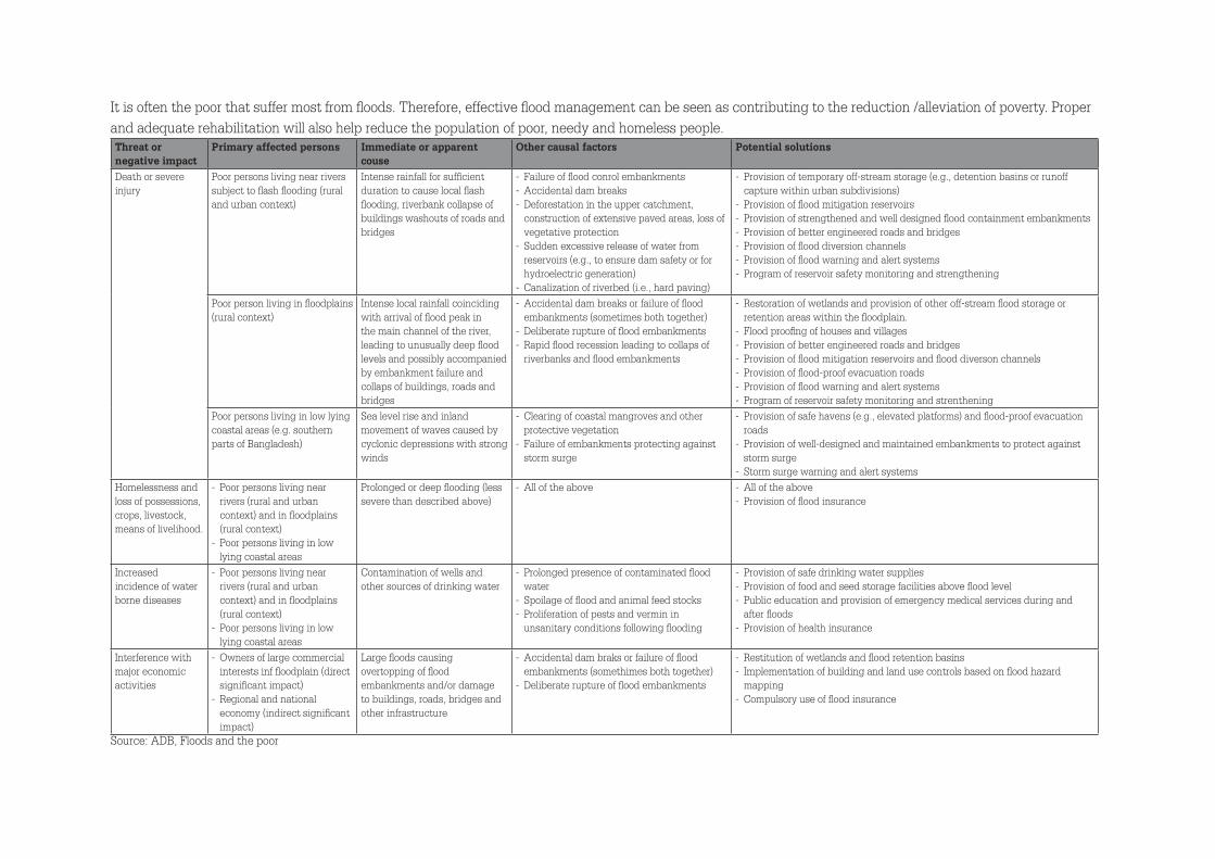
It is often the poor that suffer most from floods. Therefore, effective flood management can be seen as contributing to the reduction /alleviation of poverty. Proper and adequate rehabilitation will also help reduce the population of poor, needy and homeless people. Threat or negative impact
Primary affected persons Immediate or apparent couse
Other causal factors Potential solutions
Death or severe injury
Poor persons living near rivers subject to flash flooding (rural and urban context)
Intense rainfall for sufficient duration to cause local flash flooding, riverbank collapse of buildings washouts of roads and bridges
- Failure of flood conrol embankments - Accidental dam breaks - Deforestation in the upper catchment, construction of extensive paved areas, loss of vegetative protection
- Sudden excessive release of water from reservoirs (e.g., to ensure dam safety or for hydroelectric generation)
- Canalization of riverbed (i.e., hard paving)
- Provision of temporary off-stream storage (e.g., detention basins or runoff capture within urban subdivisions)
- Provision of flood mitigation reservoirs - Provision of strengthened and well designed flood containment embankments - Provision of better engineered roads and bridges - Provision of flood diversion channels - Provision of flood warning and alert systems - Program of reservoir safety monitoring and strengthening
Poor person living in floodplains (rural context)
Intense local rainfall coinciding with arrival of flood peak in the main channel of the river, leading to unusually deep flood levels and possibly accompanied by embankment failure and collaps of buildings, roads and bridges
- Accidental dam breaks or failure of flood embankments (sometimes both together)
- Deliberate rupture of flood embankments - Rapid flood recession leading to collaps of riverbanks and flood embankments
- Restoration of wetlands and provision of other off-stream flood storage or retention areas within the floodplain.
- Flood proofing of houses and villages - Provision of better engineered roads and bridges - Provision of flood mitigation reservoirs and flood diverson channels - Provision of flood-proof evacuation roads - Provision of flood warning and alert systems - Program of reservoir safety monitoring and strenthening
Poor persons living in low lying coastal areas (e.g. southern parts of Bangladesh)
Sea level rise and inland movement of waves caused by cyclonic depressions with strong winds
- Clearing of coastal mangroves and other protective vegetation
- Failure of embankments protecting against storm surge
- Provision of safe havens (e.g., elevated platforms) and flood-proof evacuation roads
- Provision of well-designed and maintained embankments to protect against storm surge
- Storm surge warning and alert systemsHomelessness and loss of possessions, crops, livestock, means of livelihood.
- Poor persons living near rivers (rural and urban context) and in floodplains (rural context)
- Poor persons living in low lying coastal areas
Prolonged or deep flooding (less severe than described above)
- All of the above - All of the above - Provision of flood insurance
Increased incidence of water borne diseases
- Poor persons living near rivers (rural and urban context) and in floodplains (rural context)
- Poor persons living in low lying coastal areas
Contamination of wells and other sources of drinking water
- Prolonged presence of contaminated flood water
- Spoilage of flood and animal feed stocks - Proliferation of pests and vermin in unsanitary conditions following flooding
- Provision of safe drinking water supplies - Provision of food and seed storage facilities above flood level - Public education and provision of emergency medical services during and after floods
- Provision of health insurance
Interference with major economic activities
- Owners of large commercial interests inf floodplain (direct significant impact)
- Regional and national economy (indirect significant impact)
Large floods causing overtopping of flood embankments and/or damage to buildings, roads, bridges and other infrastructure
- Accidental dam braks or failure of flood embankments (somethimes both together)
- Deliberate rupture of flood embankments
- Restitution of wetlands and flood retention basins - Implementation of building and land use controls based on flood hazard mapping
- Compulsory use of flood insurance
Source: ADB, Floods and the poor
Stationsstraat 16701 AM WageningenPhone: +31 (0) 317 84 39 39Email: [email protected]
Postbus 823272508 EH Den HaagPhone: +31 (0)70 304 3700Email: [email protected]