ideas for africa - united nations office for outer space affairs
TRANSCRIPT

IDEAS for Africa Desert Movement Predictor and FarmaBooths Two Earth-Observation Based Applications
for Pan-African Development
INTERNATIONAL SPACE UNIVERSITY 2012 Team Project on Africa
Chris Johnson Presenter


OBJECTIVE To analyze and propose innovative space spinoff
technologies, satellite applications, and space
business potentials applicable in fostering sustained social and economic development across the African continent
IDEAS for Africa
3

DESERTIFICATION Fertile lands turning arid
CAUSES • Deforestation • Over grazing • Firewood gathering • Inefficient use of water • Excessive harvesting • Transportation infrastructure • Winds, erosion & salination
The African Climate
A major challenge for sustainable growth
[Source: Westshore] 4

Using LiDAR to Measure Winds
Parameter Satellite (Instrument)
Aerosols MODIS (Aqua & Terra)
SeaStar (SeaWiFS)
Humidity MIRAS (SMOS) Land Cover MODIS (Aqua & Terra)
Precipitation TMI (TRMM) PR (TRMM)
Vegetation TM (Landsat)
MODIS (Aqua & Terra)
Wind SEVIRI (Meteosat)
ALADIN (ADM–Aeolus)
SATELLITE IMAGERY
DESERTIFICATION Sensing
[Source: ESA] 5

Land Restoration
Halting
Cultivation
Crop Conversion
Stabilizing the Sand
Shelterbelts
Fallow Band Systems China’s “Great Green Wall” preventing the advancement of the Gobi desert
[Source: Buczynski]
DESERTIFICATION Mitigation
6

Concept Annual Cost Project Cost
Satellite Imagery* $ 5 million $ 25 million Human Resources $ 1 million $ 6 million
Total $ 6 million $ 31 million
* Cost of SAR images for 3 million km2 target area
Establishing a Desert Movement Prediction Center Main Functions
: Collect satellite data : Image processing and analysis : Dune movement research : Desert movement predictions and recommendations
Main Costs
DESERTIFICATION Implementation
7

Providing satellite information for agriculture
Agriculture is a critical part of the economy, yet food insecurity is
major concern
FarmaBooths based on Indian Village
Resource Centres
Food Security in Africa
FARMABOOTHS
Local Assistance to Farmers
8

4 Segments: Space Segment
Data Interpretation Centers Centralized FarmaBooth Facility Individual FarmaBooths
Data transferred via the Pan African e–network
FARMABOOTHS The Concept
9
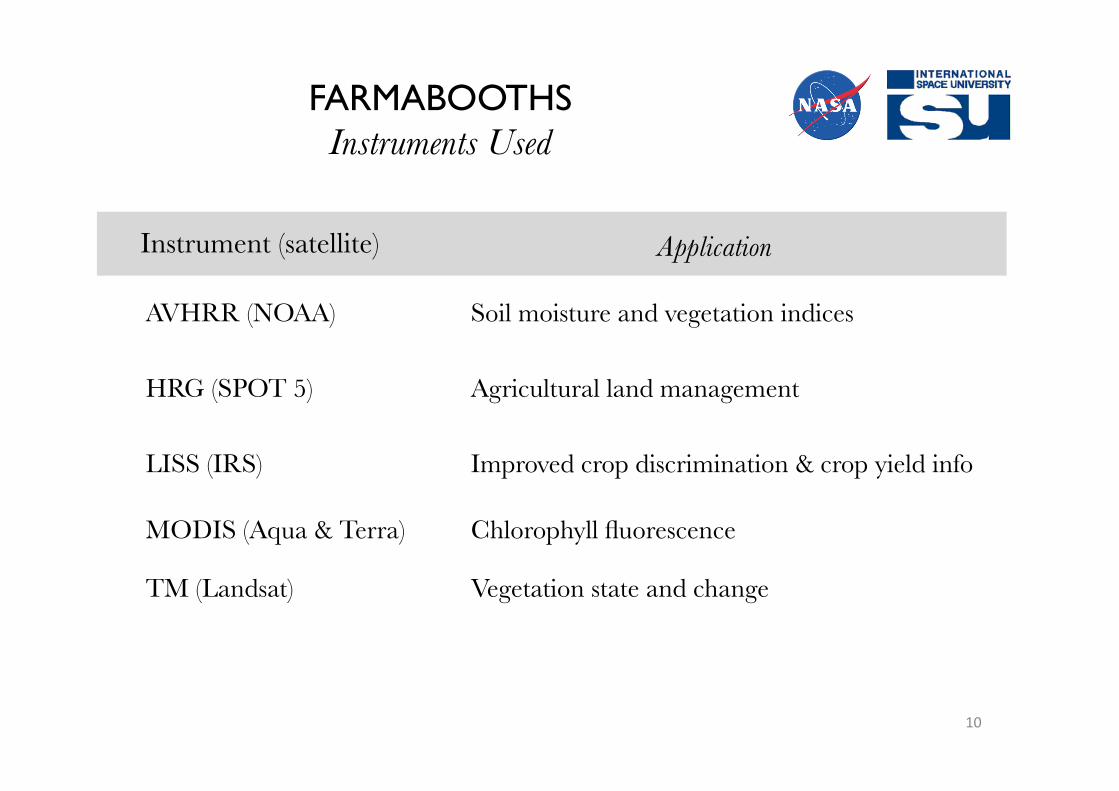
Instrument (satellite) Application
AVHRR (NOAA) Soil moisture and vegetation indices
HRG (SPOT 5) Agricultural land management
LISS (IRS) Improved crop discrimination & crop yield info
MODIS (Aqua & Terra) Chlorophyll fluorescence
TM (Landsat) Vegetation state and change
FARMABOOTHS Instruments Used
10

Item Start–up Cost Annual Cost
Centralized FarmaBooth Centers Human Resources – $11,000 Building Rental Fees – $1,000
FarmaBooth Satellite Connectivity $1,000 – Construction $2,000 – Power Requirements $6,000 –
Interpretation Center VRC Services – $20,000
Imagery
SPOT Imagery – $15,000 Total $9,000 $47,000
Village Resource Center (VRC) services based on human resources costs per
year
Imagery costs: assume 12 photos per year with scene
size of 20km x 20km
Costs for Establishing One FarmaBooth FARMABOOTHS Implementation
11

Africa.isunet.edu click on
Final Report in PDF
Thank You
IDEAS for Africa