idaho airport system plan 20 0 - idaho transportation...
TRANSCRIPT

2010Idaho Airport System Plan
Executive Summary

IntroductionThe Idaho Transportation Department (ITD) Division of Aeronautics has a long history in aviation. From serving the state’s backcountry to providing opportunities for international passenger travel and meeting the needs of businesses, airports are an integral component of the transportation system. In addition to serving transportation needs, Idaho’s airports support the economy through the creation of jobs, provision of emergency transport and access, and allow tourism to flourish in the Gem State.
Study PurposeThe ITD Division of Aeronautics’ mission is to...
“provide the highest quality, most effective, efficient, and safest airport system for all users of aviation services. To this end, the Division of Aeronautics plans and implements essential programs, services and projects to develop, encourage, and foster an exemplary system of airports that meet the current and future requirements of a growing and diverse Idaho aviation community.”
To ensure that the state’s airport system is developed to meet all of the transportation, economic, and safety needs, ITD Division of Aeronautics initiated the Idaho Airport System Plan (IASP). This comprehensive study follows a strategic approach to provide a blueprint to insure
that Idaho’s future system of airports meets the state’s needs as viewed at a macro or top down perspective. This approach allows each airport’s role in the system, its demand for aviation, and infrastructure to be evaluated in this larger context. This study can also be used to provide increased accountability for funding decisions.
The IASP also encompasses several related elements that help to support the study’s findings:
Economic Impact StudyLand Use Guidelines
These two additional elements help to frame the airport system’s contribution to the state’s economy and identify what is needed to help protect important investment.
••
Photo: Garden Valley airPort
�
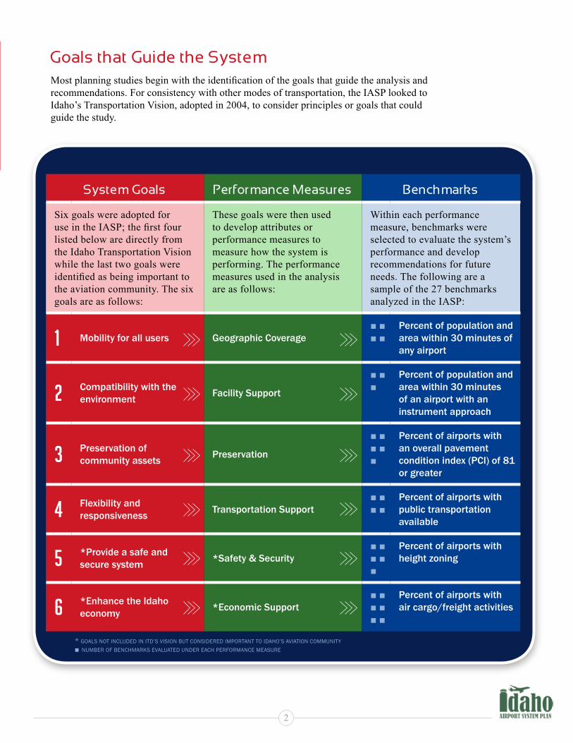
Goals that Guide the SystemMost planning studies begin with the identification of the goals that guide the analysis and recommendations. For consistency with other modes of transportation, the IASP looked to Idaho’s Transportation Vision, adopted in 2004, to consider principles or goals that could guide the study.
System Goals Performance Measures Benchmarks
Six goals were adopted for use in the IASP; the first four listed below are directly from the Idaho Transportation Vision while the last two goals were identified as being important to the aviation community. The six goals are as follows:
These goals were then used to develop attributes or performance measures to measure how the system is performing. The performance measures used in the analysis are as follows:
Within each performance measure, benchmarks were selected to evaluate the system’s performance and develop recommendations for future needs. The following are a sample of the 27 benchmarks analyzed in the IASP:
1 Mobility for all users Geographic Coverage■ ■■ ■
Percent of population and area within 30 minutes of any airport
2 Compatibility with the environment Facility Support
■ ■ ■
Percent of population and area within 30 minutes of an airport with an instrument approach
3 Preservation of community assets Preservation
■ ■ ■ ■■
Percent of airports with an overall pavement condition index (PCI) of 81 or greater
4 Flexibility and responsiveness Transportation Support
■ ■ ■ ■
Percent of airports with public transportation available
5 *Provide a safe and secure system *Safety & Security
■ ■ ■ ■ ■
Percent of airports with height zoning
6 *Enhance the Idaho economy *Economic Support
■ ■ ■ ■ ■ ■
Percent of airports with air cargo/freight activities
* Goals not included in itd’s Vision but considered imPortant to idaho’s aViation community■ number of benchmarks eValuated under each Performance measure
2

The Existing Idaho Airport SystemThe operational and geographic diversity of Idaho’s airport system facilitates a wide range of users. With that in mind, the IASP analyzed 75 of the 119 public use airports in the system, focusing first on those airports identified in the Federal Aviation Administration’s (FAA’s) National Plan of Integrated Airport Systems (NPIAS) and adding other airports based on activity, state ownership, and location within the state. Idaho also maintains the Idaho Airstrip Network (IAN) for many of the backcountry or remote airports.
The 75 IASP airports represent the following:
87 runways in the system including 3 water runways at seaplane bases
23 runways that are more than 5,000 feet in length
63 paved runways, 13 turf-only runways, and 3 water runways
18 airports with automated on-site weather reporting
38 airports with fuel service
8 airports with more than 100 based aircraft
14 airports with more than 25,000 annual operations
•
•
•
•
•
•
•
Roles of Idaho’s AirportsIn a system of 75 airports, the functions or roles of the airports vary from personal flying to serving commercial airlines. The FAA primarily categorizes airports based only on the availability of commercial service but does not determine the function or roles that airports play within a state system. For Idaho, the analysis of airport roles focused on examining aviation and non-aviation factors that relate to development of a successful system of airports. Specific factors were selected to determine each airport’s role in a consistent, quantitative process. Based on this process, five airport role categories were selected, with each Idaho airport assigned to one of these five categories. Several airports are noted to serve one role today but are recommended to serve another role in the future to meet demand.
Commercial Service
Regional Business
Community Business
Local Recreational
Basic Service
�

15
86
84
84
90
Commercial Service airports accommodate scheduled major/national or regional/commuter commercial air carrier service in addition to air cargo, business aviation, and all types of general aviation. (7 airports)
Regional Business airports support regional economic activities, connecting to state and national economies, and serve all types of general aviation aircraft. They also accommodate local business activities and various types of general aviation users. (16 airports)
Community Business airports serve a limited role in regional economies, primarily supporting community economies. They accommodate a variety of general aviation activities such as business, recreational, and personal flying. (19 airports)
Local Recreational airports serve a supplemental role in local economies, primarily accommodating recreational, personal flying, and limited local business activities. (16 airports)
Basic Service airports serve a limited role in the local economy, primarily accommodating recreational and personal flying. (17 airports)
Recommended Airport Role Classifications
recommended future regional business
recommended future community business
note: airPorts labeled by associated citysource: Wilbur smith associates; PrePared July 2009
�
Porthill
Bonners Ferry
Coolin
Priest riverSandpoint
Coeur D’Alene
BrooksKellogg
St MarieS
OrOfinO
Nez Perce
Kamiah
KoosKia
GranGevilleCottonwood
Lewiston
Craigmont
Snake RiveR
Elk City
Big Creek
Yellow PineMccall
Donnelly
CounCil
Midvale CasCade
Weiser
Payette
EmmEttParma
HomedaleCaldwell
BoiseNampa
Murphy Mountain HoMe
Glenns Ferry
GoodinG
Buhl
Twin Falls
Jerome
Hazelton
Burley
Oakley
Aberdeen
RockfoRd
Pocatello
AmericAn FAlls
Blackfoot
Bancroft
Soda SpringS
Paris
Preston
Downey
Malad City
Idaho FallsRigby
Driggs
St Anthony
RexbuRg
Dubois
Mud Lake
MackayHowe
Carey
ArcoHailey
FairField
Galena
Stanley
Challis
Salmon
Leadore
Garden Valley
Moscow

Analyzing the System of AirportsToday, analysis of transportation systems focuses on the performance of the mode and how investment can improve the performance. For Idaho’s airport system, the six system performance measures served as the baseline, with specific benchmarks within each measure used to quantify the performance. Once all benchmarks are evaluated, the overall performance of the measure is determined and specific actions to improve the system can be determined.
Of the 27 benchmarks selected for analysis of the Idaho airport system’s performance, many are considered informational, providing ITD and the airports with data for future tracking and monitoring. Other benchmarks offer the opportunity for action to improve the performance.
For example, the benchmark that analyzed the percent of airports that support aerial application activities does not have a specific project associated with changing its performance and is considered informational. However, an airport can install an Automated Weather Observing System (AWOS) increasing the number of airports with on-site reporting facilities and thereby increasing the system performance of this benchmark as shown on the following pages. By monitoring the ability of the Idaho airport system to satisfy or meet each of the benchmarks, the Division of Aeronautics can compare and monitor current, target, and future system performance.
Sample Benchmark: Pavement Condition Index (PCI) of 81 or Greater
0 20 40 60 80 100
0 20 40 60 80 100
commercial service
regional business
community business
local recreational
basic service
Statewide
86% 14%
41% 59%
67% 33%
13% 62%
6% 58%
37% 27%
25%
18% 18%
32% 4%
Sample Benchmark: Airports meeting weather reporting facility objectives
commercial service
regional business
community business
local recreational
basic service
Statewide
100%
56% 44%
6%
65% 35%
meet does not meet not available not an obejective
6% 88%
100%
100%
�

15
86
84
84
90
Sample Benchmark:Current and Recommended Airports With
On-site Weather Reporting Equipment
Future Role:
Commercial Service
Regional Business
Community Business
Local Recreational
Basic Service
Recommended Regional Business
Recommended Community Business
ASOS
AWOS
Recommended
note: airPorts labeled by associated citysource: Wilbur smith associates; PrePared July 2009
(25 airports)
(12 airports)
(6 airports)
Weather Reporting Equipment:
�
Porthill
Bonners Ferry
Coolin
Priest riverSandpoint
Coeur D’Alene
BrooksKellogg
St MarieS
OrOfinO
Nez Perce
Kamiah
KoosKia
GranGevilleCottonwood
Lewiston
Craigmont
Snake RiveR
Elk City
Big Creek
Yellow PineMccall
Donnelly
CounCil
Midvale CasCade
Weiser
Payette
EmmEttParma
HomedaleCaldwell
BoiseNampa
Murphy Mountain HoMe
Glenns Ferry
GoodinG
Buhl
Twin Falls
Jerome
Hazelton
Burley
Oakley
Aberdeen
RockfoRd
Pocatello
AmericAn FAlls
Blackfoot
Bancroft
Soda SpringS
Paris
Preston
Downey
Malad City
Idaho FallsRigby
Driggs
St Anthony
RexbuRg
Dubois
Mud Lake
MackayHowe
Carey
ArcoHailey
FairField
Galena
Stanley
Challis
Salmon
Leadore
Garden Valley
Moscow
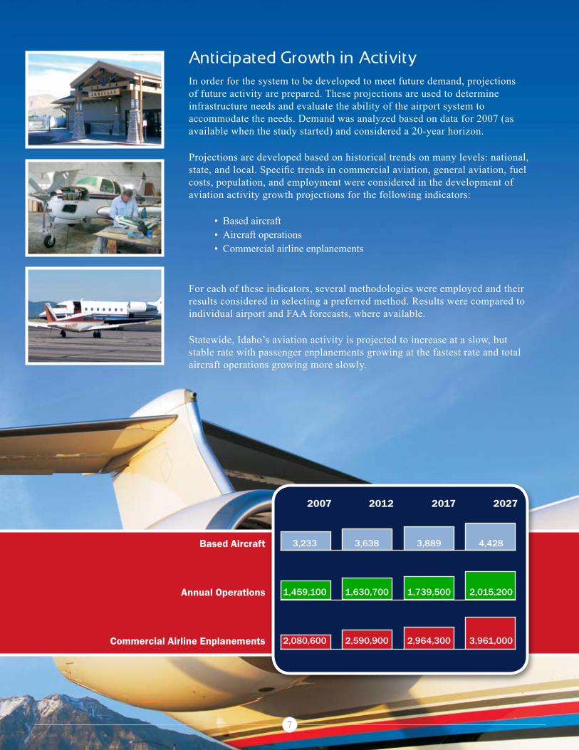
Anticipated Growth in ActivityIn order for the system to be developed to meet future demand, projections of future activity are prepared. These projections are used to determine infrastructure needs and evaluate the ability of the airport system to accommodate the needs. Demand was analyzed based on data for 2007 (as available when the study started) and considered a 20-year horizon.
Projections are developed based on historical trends on many levels: national, state, and local. Specific trends in commercial aviation, general aviation, fuel costs, population, and employment were considered in the development of aviation activity growth projections for the following indicators:
Based aircraftAircraft operationsCommercial airline enplanements
For each of these indicators, several methodologies were employed and their results considered in selecting a preferred method. Results were compared to individual airport and FAA forecasts, where available.
Statewide, Idaho’s aviation activity is projected to increase at a slow, but stable rate with passenger enplanements growing at the fastest rate and total aircraft operations growing more slowly.
•••
2007 2012 2017 2027
Based Aircraft 3,233 3,638 3,889 4,428
Annual Operations 1,459,100 1,630,700 1,739,500 2,015,200
Commercial Airline Enplanements 2,080,600 2,590,900 2,964,300 3,961,000
7

Total Economic Impacts
Economic ImpactMost public airports generate some form of economic activity whether or not they have aviation businesses on site or just accommodate recreational activity. In order to quantify the economic contribution of the airports, an FAA approved methodology was employed to consistently measure this contribution. While a previous study was conducted to determine the economic impact of airports, this analysis provided a more in-depth and updated approach to calculate a current economic impact associated with each airport.
The total economic impact of each Idaho airport is quantified in terms of employment, payroll, and output. Output represents total spending or economic activity and accounts for the total value of aviation-related activities supported by the airports. Benefits of Idaho’s airports consist of first-round or direct and indirect impacts associated with aviation services being provided. Secondary impacts include induced or “recirculated” impacts that result from the first-round spending. First-round and secondary impacts are added together to determine the total economic impact of each Idaho airport.
The IASP’s system of 75 public use airports generates $2.1 billion of economic activity and supports tens of thousands of quality jobs. In addition, Idaho residents increasingly depend on civil aviation to support their health, welfare, and safety needs. In brief, the 75 public use airports included in the IASP are responsible for:
23,000 ToTal jobS
$718.5 million In annual PayRoll
$2.1 billion In annual EConoMIC aCTIvITy
Other findings include:
aviation’s total economic output from the airports and visitors who arrive by air comprise 4.0 percent of the state’s estimated gross domestic product.
approximately 23,000 idaho residents owe their jobs, directly or indirectly, to aviation. this employment represents 2.9 percent of all jobs in the state.
idaho’s airports serve as vital business links and support critical services such as medical care, agriculture support, search and rescue, wildland fire fighting, law enforcement, recreation, and environmental services.
•
•
•
Direct Impacts
Indirect Impacts
Induced Impacts
FIR
St R
ou
nd
SE
Co
nd
AR
yto
tAL
ou
tPu
t
�
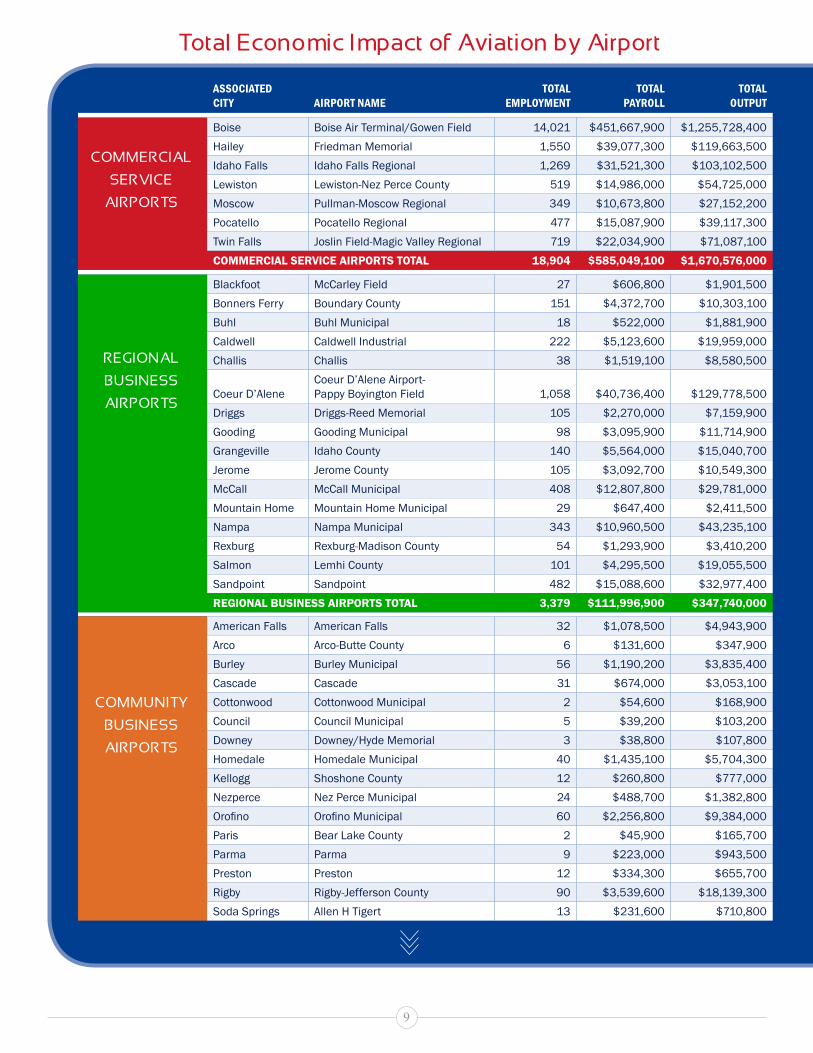
AssociAted city Airport NAme
totAl employmeNt
totAl pAyroll
totAl output
boise boise air terminal/Gowen field 14,021 $451,667,900 $1,255,728,400hailey friedman memorial 1,550 $39,077,300 $119,663,500idaho falls idaho falls regional 1,269 $31,521,300 $103,102,500lewiston lewiston-nez Perce county 519 $14,986,000 $54,725,000moscow Pullman-moscow regional 349 $10,673,800 $27,152,200Pocatello Pocatello regional 477 $15,087,900 $39,117,300twin falls Joslin field-magic Valley regional 719 $22,034,900 $71,087,100COmmErCIAl SErvICE AIrpOrTS TOTAl 18,904 $585,049,100 $1,670,576,000
blackfoot mccarley field 27 $606,800 $1,901,500bonners ferry boundary county 151 $4,372,700 $10,303,100buhl buhl municipal 18 $522,000 $1,881,900caldwell caldwell industrial 222 $5,123,600 $19,959,000challis challis 38 $1,519,100 $8,580,500
coeur d’alenecoeur d’alene airport- Pappy boyington field 1,058 $40,736,400 $129,778,500
driggs driggs-reed memorial 105 $2,270,000 $7,159,900Gooding Gooding municipal 98 $3,095,900 $11,714,900Grangeville idaho county 140 $5,564,000 $15,040,700Jerome Jerome county 105 $3,092,700 $10,549,300mccall mccall municipal 408 $12,807,800 $29,781,000mountain home mountain home municipal 29 $647,400 $2,411,500nampa nampa municipal 343 $10,960,500 $43,235,100rexburg rexburg-madison county 54 $1,293,900 $3,410,200salmon lemhi county 101 $4,295,500 $19,055,500sandpoint sandpoint 482 $15,088,600 $32,977,400rEgIOnAl BuSInESS AIrpOrTS TOTAl 3,379 $111,996,900 $347,740,000
american falls american falls 32 $1,078,500 $4,943,900arco arco-butte county 6 $131,600 $347,900burley burley municipal 56 $1,190,200 $3,835,400cascade cascade 31 $674,000 $3,053,100cottonwood cottonwood municipal 2 $54,600 $168,900council council municipal 5 $39,200 $103,200downey downey/hyde memorial 3 $38,800 $107,800homedale homedale municipal 40 $1,435,100 $5,704,300kellogg shoshone county 12 $260,800 $777,000nezperce nez Perce municipal 24 $488,700 $1,382,800Orofino Orofino Municipal 60 $2,256,800 $9,384,000Paris bear lake county 2 $45,900 $165,700Parma Parma 9 $223,000 $943,500Preston Preston 12 $334,300 $655,700rigby rigby-Jefferson county 90 $3,539,600 $18,139,300soda springs allen h tigert 13 $231,600 $710,800
total Economic Impact of Aviation by Airport
CoMMERCIAL
SERvICE
AIRPoRtS
REGIonAL
BuSInESS
AIRPoRtS
CoMMunIty
BuSInESS
AIRPoRtS
�

AssociAted city Airport NAme
totAl employmeNt
totAl pAyroll
totAl output
st anthony stanford field 5 $113,200 $333,300st maries st maries municipal 13 $294,700 $1,116,200
Weiser Weiser municipal 41 $964,700 $3,579,800COmmunITy BuSInESS AIrpOrTS TOTAl 456 $13,395,300 $55,452,600
aberdeen aberdeen municipal 16 $701,800 $2,143,400big creek big creek 3 $43,600 $111,200coolin cavanaugh bay 4 $85,700 $224,100craigmont craigmont municipal 7 $168,300 $456,800emmett emmett municipal 9 $167,100 $444,700Galena smiley creek 4 $84,600 $208,100Garden Valley Garden Valley 3 $65,100 $155,900hazelton hazelton municipal 15 $335,500 $1,285,000kamiah kamiah municipal 2 $26,400 $171,100kooskia kooskia municipal 1 $19,300 $49,300Payette Payette municipal 4 $125,600 $311,100Porthill eckhart international 27 $1,114,600 $1,929,800Priest river Priest river municipal 55 $2,042,600 $8,412,700rockford rockford municipal 2 $39,200 $99,300stanley stanley 5 $166,900 $998,700yellow Pine Johnson creek 5 $103,600 $237,900lOCAl rECrEATIOnAl AIrpOrTS TOTAl 162 $5,289,900 $17,239,100
bancroft bancroft municipal 5 $104,900 $331,600carey carey 2 $46,100 $124,000coeur d’alene brooks sPb 5 $150,700 $181,300donnelly donald d. coski memorial 3 $72,400 $295,500dubois dubois municipal 2 $26,500 $66,300elk city elk city 6 $119,400 $462,500Fairfield camas county 3 $66,000 $169,300Glenns ferry Glenns ferry municipal 1 $15,600 $46,900howe howe 2 $60,200 $153,700leadore leadore 1 $19,400 $48,400lewiston snake river sPb 1 $12,500 $30,800mackay mackay 2 $34,600 $93,700malad city malad city 3 $67,700 $172,500midvale lee Williams memorial 11 $420,800 $1,658,100mud lake mud lake/West Jefferson county 45 $1,439,600 $2,294,200murphy murphy 5 $101,200 $261,700oakley oakley municipal 2 $29,300 $73,500BASIC SErvICE AIrpOrTS TOTAl 99 $2,786,900 $6,464,000
All AIrpOrTS TOTAl 23,000 $718,517,800 $2,097,463,200
source: Wilbur smith associates and imPlan multiPliers; PrePared sePtember 2009
total Economic Impact of Aviation by Airport (Continued)
CoMMunIty
BuSInESS
AIRPoRtS
LoCAL
RECREAtIonAL
AIRPoRtS
BASIC
SERvICE
AIRPoRtS
�0

Land UseAirports are viewed as a transportation asset in most areas but protecting airports from incompatible land uses is often neglected when communities plan for future growth needs. While typically located on large parcels of relatively undeveloped land, airports require access both from the ground and air, with aircraft starting their approach several miles from the actual landing site of the runway. Property that is developed around airports can be subjected to noise and can actually interfere with airport operations depending on the height and type of building or development. Proper land use planning for the community must consider the airport’s needs related to safety for the area around the airport and protecting the investment in the facilities that are developed at the airport. As previously noted, airports are economic catalysts for other growth and development and providing opportunities for compatible development of business and industry near airports is good for the community and the airport.
The primary responsibility for integrating airport considerations into the local land use planning process rests with local land use planning agencies and local governments. Coordination across multiple jurisdictions to achieve airport land use compatibility is vital for successful protection and promotion of compatible development.
In order to assist communities with land use planning related to airports, the Division of Aeronautics developed the Idaho Airport Land Use Guidelines as a companion component of the IASP. The land use guidelines discuss the relevant issues, current state codes related to airport land use compatibility, and outline the specific steps that can be taken to support compatible land use zoning and development for airports.
The local planning documents that need to incorporate airport and land use compatibility issues include:
Local comprehensive plans (city and county)Local zoning ordinancesLocal zoning mapsAirport master plans
••••
��

Example Land Use Zone Map
source: t-o enGineers; PrePared July 2009
The graphic below represents an example of the recommended approach to developing a Land Use Zone Map around airports as included in the land use guidelines. While each airport’s size, activity levels and local governmental process will dictate specific requirements, identifying such items as the overall area of influence, traffic pattern and critical zones is a vital step in the process. Combined with the development of an airspace map and airspace projections, the recommendations included in the guidelines will help airport owners protect their airports from incompatible development by ensuring the safety of both aircraft operators and neighbors, and the overall public investment and long-term economic viability of the airport.
�2
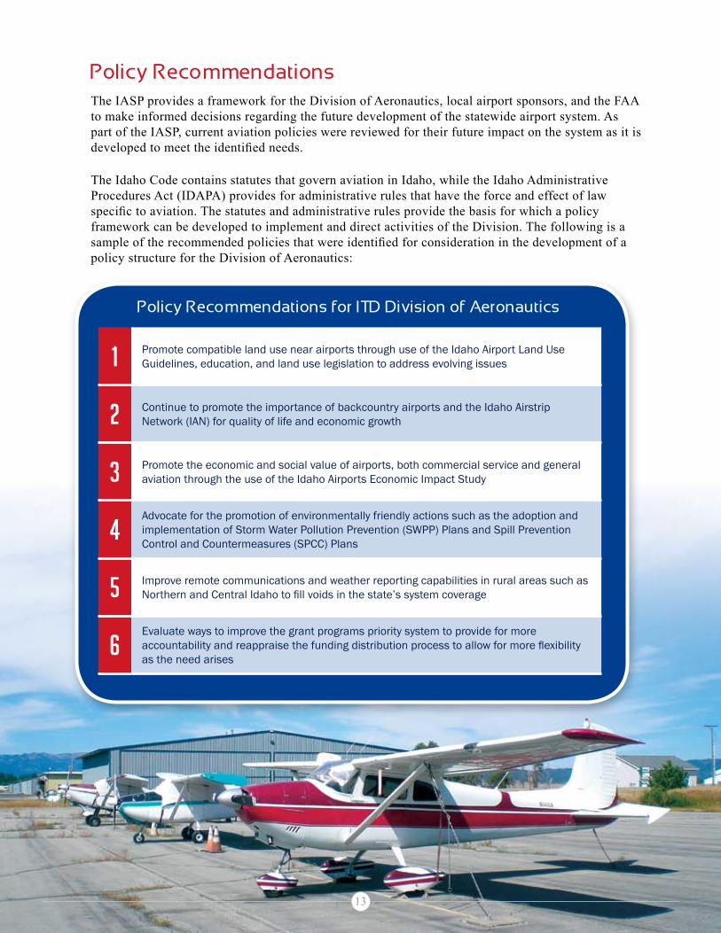
Policy RecommendationsThe IASP provides a framework for the Division of Aeronautics, local airport sponsors, and the FAA to make informed decisions regarding the future development of the statewide airport system. As part of the IASP, current aviation policies were reviewed for their future impact on the system as it is developed to meet the identified needs.
The Idaho Code contains statutes that govern aviation in Idaho, while the Idaho Administrative Procedures Act (IDAPA) provides for administrative rules that have the force and effect of law specific to aviation. The statutes and administrative rules provide the basis for which a policy framework can be developed to implement and direct activities of the Division. The following is a sample of the recommended policies that were identified for consideration in the development of a policy structure for the Division of Aeronautics:
1 Promote compatible land use near airports through use of the idaho airport land use Guidelines, education, and land use legislation to address evolving issues
2 continue to promote the importance of backcountry airports and the idaho airstrip network (ian) for quality of life and economic growth
3 Promote the economic and social value of airports, both commercial service and general aviation through the use of the idaho airports economic impact study
4advocate for the promotion of environmentally friendly actions such as the adoption and implementation of storm Water Pollution Prevention (sWPP) Plans and spill Prevention control and countermeasures (sPcc) Plans
5 improve remote communications and weather reporting capabilities in rural areas such as Northern and Central Idaho to fill voids in the state’s system coverage
6evaluate ways to improve the grant programs priority system to provide for more accountability and reappraise the funding distribution process to allow for more flexibility as the need arises
Policy Recommendations for Itd division of Aeronautics
��

System Investment NeedsAll of the analyses conducted as part of the IASP lead up to the determination of system investment needs. All of the study’s recommendations do not have an associated cost, but investment is needed at all levels to administer, maintain, and develop Idaho’s airport system. Over the next 20 years, approximately $739 million is needed to meet the infrastructure needs of the majority of the airport system. This level of aviation investment can come from a variety of sources such as the FAA and state funding, but investment will also be required from the local communities that benefit from the airports.
While this funding equates to roughly $36.9 million per year on average, it is important to note that the economic benefit derived from the investment is nearly $2.1 billion per year and the airports support over 23,000 jobs.
Other Recommendations A sample of the additional recommendations include:
20-year total development Cost by Role
Airport roleestimAted 20-yeAr
developmeNt costs
commercial service $431,207,500
regional business $199,892,200
community business $82,698,400
local recreational $19,249,000
basic service $5,787,200
Total $738,834,300
source: Wilbur smith associates and t-o enGineers; PrePared october 2009
Consider including the following system airports in the nPIaS: american Falls, Emmett, Garden valley, and Rigby
Develop a comprehensive airports System Manager (aSM) database to track IaSP data, project funding, and Capital Improvement Plan (CIP) information
Continue to encourage system airports to implement appropriate security measures
Support the need for a commercial service airport to replace Friedman Memorial in the Wood River Region; support the need for a regional airport study in valley County
This amount of funding is an average 12% increase from the current level provided by the FAA, state of Idaho, and local airport owners combined. The state of Idaho can meet this funding level with an average increase of $145,000 annually.
��

3483 Rickenbacker St., boise, ID 83705 P.o. box 7129, boise, ID 83707-1129 Phone: 1-208-334-8775 In-state toll free: 1-800-426-4587 FaX: 1-208-334-8789www.itd.idaho.gov/aero/
For more information, contact:
Prepared by:
With: