icg systems working group - unoosa.org
TRANSCRIPT
07 September 2019
ISPRA, Italy
ICG Systems Working Group (WG-S) Systems, Signals, and Services
2019 Intersessional Presentation

Systems, Signals, and Services WG (WG-S)
Systems, Signals, and Services WG
Compatibility & Spectrum Sub-group
Interoperability & Service Standards Sub-group
▪ Signal Compatibility
▪ Spectrum Protection
▪ IDM Standards & Information Exchange
▪ User level Multi-GNSS interoperability and use (signal, system time and geodesy reference)
▪ Signal, open service, standards development, monitoring and assessment
System-of-System Operations
▪ Orbital Debris Mitigation
▪ Orbit Deconfliction
▪ Constellation Optimization for performance improvement
IDM Task Force will continue under the sub-group
IGMA Task Force will continueunder the sub-group
Specific Tasks to be managed by Co-chairs until the need for a permanent sub-group can be determined

2019 Intersessional Working Group Schedule
• 8th IDM Workshop – Baska, Croatia, May
• Compatibility & Spectrum Subgroup meeting – Baska, Croatia, May
• Interoperability & Service Standards Subgroup meeting –Vienna, 11 June
• Performance Standards and IGMA Workshop – Vienna, 12-13 June
• 3rd Timing Workshop – Vienna, 14 June
• 4th Regional Spectrum Protection Seminar – Suva, Fiji, 25-26 June
• Joint WG-S, WG-B and WG-D Workshop on Precise Point Positioning (PPP) – Suva, Fiji, 27 June
• WG-S Intersession Meeting – Ispra, Italy, 4-7 September

SYSTEM UPDATES

• In the constellation 22 satellites are operational and healthy
– 21 sats are Glonass-M
– 1 sat Glonass-K1
• Two satellites Glonass-M (with exceeded design life time) are in the orbital reserve and can be operational with reduced performance
• Recently dead satellite Glonass-M # 42 (second orbital plane) is under investigation and could survive after two weeks passing the shadows
• Fresh Glonass-M satellite from the ground reserve is prepared to launch originally planned for November 2019. Two more Glonass-M satellites are still in the ground reserve waiting for launch
GLONASS (1)

• Nine Glonass-K1 satellites are in the final phase of manufacture. First satellite from the nine shall be ready for launch by the end of 2019
• Four Glonass-K1 satellites from this nine will carry onboard the COSPAS-SARSAT payload and L3 signal in addition to full set of FDMA
• Five Glonass-K1 satellites from this nine will transmit also L2 CDMA signal in addition to FDMA and L2 CDMA signal
• New generation Glonass-K2 satellite is in the development expecting the flight test start by the end of 2022
• Further constellation sustainment will be done with Glonass-K2 satellites transmitting full set of FDMA in L1 and L2 and full set of CDMA in L1, L2, L3 bands
GLONASS (2)

GPS (1)
• GPS Constellation Status:
– 36 Satellites / 31 Set Healthy Baseline Constellation: 24 Satellites

GPS (2)• GPS III Space Vehicles
– SV01 launched 23 Dec 18; currently undergoing on-orbit check out
– SV02 launched 22 Aug 19; currently undergoing on-orbit check out
– SV03 Available for Launch; planned for fall 2019
• GPS III Follow-On (GPS IIIF)– GPS IIIF Contract awarded on 26 Sep 18
– Will leverage production maturity of GPS III SV01-10
– Partnering with Air Force Research Laboratory (AFRL) for technology opportunities:
• Digital Payloads
• High Power Amplifiers
• Advanced Clocks
• Near Real-Time Commanding/Crosslinks

• The Galileo constellation is currently composed of 22 operational satellites, two satellites in anomalous orbits, plus one spare. Further procurements are in progress and launches are expected in 2020
• Regular performance exceeds expectations…
• The July incident that affected Galileo’s provision of timing and navigation was due to a problem in one part of the ground infrastructure
• An important upgrade in progress, affected the usual redundancy
• As a result, the Galileo navigation message could not be generated and uploaded to the satellites
• Note that Galileo’s signals remained available and that SAR provision was unaffected
• Galileo services are now fully restored and measures have already been put in place to avoid similar incidents
• A review board is fully analysing the incident
• The full incident review will help identify measures to make Galileo’s services as robust as possible in time for declaration of full operational capability in 2020
GALILEO
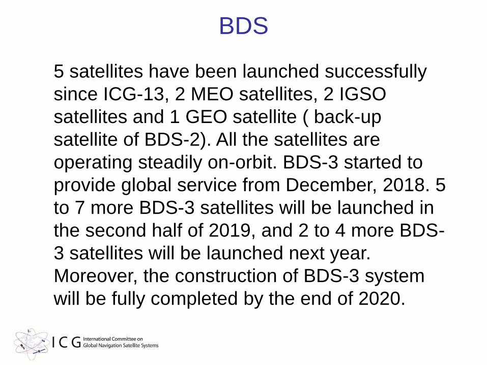
BDS
5 satellites have been launched successfully
since ICG-13, 2 MEO satellites, 2 IGSO
satellites and 1 GEO satellite ( back-up
satellite of BDS-2). All the satellites are
operating steadily on-orbit. BDS-3 started to
provide global service from December, 2018. 5
to 7 more BDS-3 satellites will be launched in
the second half of 2019, and 2 to 4 more BDS-
3 satellites will be launched next year.
Moreover, the construction of BDS-3 system
will be fully completed by the end of 2020.

• To be provided
QZSS
• No Report
NAVIC

COMPATIBILITY and SPECTRUM
co-chairs
Dominic HAYESTakahiro MITOME

• Co-chairs:
– Takahiro MITOME, Japan
– Dominic HAYES, EU
• Members:
– China: Shengtao GUO, Lin LI, Weimin ZHEN
– European Union: Dominic HAYES
– India: S. SAYEENATHAN,K. K. SOOD
– Japan: Yoshimi OHSHIMA
– Russia: Dmitry ARONOV
– United States: Karen Van Dyke, Rick Hamilton, David Choi
Compatibility & Spectrum ProtectionSub-group
Objectives of Compatibility and Spectrum Sub-Group
• Compatibility issues and information sharing regarding the protection of GNSS spectrum from interference from other radio services, as well as IDM issues;
• Document agreed results in the form of findings, reports, or whatever form may be appropriate for the case;
• Provide proposals to WG-S on compatibility issues, for discussion and decision.
15

Interference Detection & Mitigation Task Force • Co-Chairs:
– Rick Hamilton, U.S., Co-lead [email protected]
– Weimin Zhen, China, Co-lead [email protected]
• Members:
– Matteo Paonni, EU [email protected]
– Rafael Lucas-Rodriguez, ESA [email protected]
– Stanislav Kizima, Russia [email protected]
– Dmitry Aronov, Russia [email protected]
– Wen XIONG, China [email protected]
– Lin LI, China [email protected]
– Takahiro Mitome, Japan [email protected]
– Yoshimi Ohshima, Japan [email protected]
– Kei Narisawa, Japan [email protected]
– Robyn Anderson, USA [email protected]
– George FAN, USA [email protected]
– Deok Won Lim, ROK [email protected]

8TH Interference Detection and Mitigation
Workshop - Baska, Croatia
14 May 2019

International Committee on GNSS (ICG)8th IDM Workshop
Royal Institute of Navigation (RIN) Baška GNSS ConferenceBaška, Croatia 14-15 May, 2019
UN
14 May, 2019 (Open to all conference participants and ICG WG-S members)
1500: Opening Discussion / Introductions
1510: Development and Operation of a GPS Jammer Localization System at Incheon International Airport - Dr. Deok Won Lim, Ph.D./Senior Researcher, Navigation R&D Division, Korea Aerospace Research Institute
1530: Measurement Test of Purchased Radio Equipment - Short Range Device -Mr. Takahiro Mitome, SKY Perfect JSAT Corporation
1550: Interference from Amateur Services to GNSS within the 1260-1300 MHz band (Galileo E6 /BeidouB3 band ) – Mr. Matteo Paonni, Scientific/Technical Officer, European Commission, Joint Research Centre

1610: Project Introduction: GNSS Interference Detection and Localization in the City -Ms. JIN Ruimin, China Research Institute of Radio-wave Propagation
1640: Systematization of Information on Various Types of GNSS Receivers and Various Types of Interference – Mr.Egor Zheltonogov, Geyser-Telecom Ltd.
1710: GNSS RFI Status Downlink– Mr. Gerhard Berz, Focal Point Navigation Infrastructure, EUROCONTROL (by Teleconference)
1740: Аctual Question of Monitoring in the Navigation Situation – Mr. Sergey Silin, Design Bureau of Navigation Systems (NAVIS Inc.)
1800: Discussion
Adjourn


21
Conclusions
◼ System verification tested in indoors environment
◼ Week-long live-sky test provided results indicating real jamming case, <6 second localization and position origin of interference signal.
▪ South Korea experiences nation-state purposeful jamming affecting thousands of wireless communications stations, ships and aircraft.
▪ Localization system developed and tested at Incheon International Airport using algorithms guaranteeing integrity and continuity of air navigation systems.

Measurement Test of Short Range Device Samples
The 8th Interference Detection and Mitigation (IDM) Workshop
- International Committee on GNSS (ICG) -
14 May 2019
Takahiro MITOME (Japan)

Measurement Test of Short Range Device Samples in Japan
• In Japan, electromagnetic emission limits of non-licensed emitters are defined and a
“Measurement Test of Short Range Device (SRD) Samples” is conducted every year.
• In this test, some commercially available non-licensed emitters/devices are randomly
selected, purchased by the telecommunication administration and checked for compliance
with established limitations.
• In this year’s test, one device was found to exceed the limit at the frequency of 1585.464
MHz, as shown below.
• An example of Japan’s regulatory process to suppress devices which produce larger
emissions than allowable. It is encouraged that each country exchange in ICG their practical
framework for the prevention of GNSS jammers.
Frequency (MHz)
Polarization Measured result (mV/m) Limit(mV/ m)
1585.464 Horizontal 389045.1 35
1585.464 Vertical 131825.7 35

Compatibility Assessment Between Amateur Radio Services and Galileo in the E6 Band
• M. Paonni
Joint Research Center (JRC), European Commission, Ispra, Italy
8th Workshop on Interference
Detection and Mitigation
Baska, Croatia
14.05.2019
The European Commission’s in-house science service

27 December 2019
• Experimental tests with live signals were carried out using high-end E6-enabled receivers and a testplan coordinated with IARU members
• Realistic scenarios have been considered with a variety of emissions with different power/distance profiles
• Very important degradation for different KPIs (C/N0, Pseudorange variance and Bit Error Rate) for different E6 receivers measured
• Noting the ATV impacts on the Galileo E6 signals (and certainly other RNSS systems using the same frequencies):
✓ AS already acknowledges its secondary status and has indicated compliance where necessary
• but, additional radio regulatory decisions may be required
✓ Galileo working with EU national authorities to determine appropriate measures
✓ wider decisions at CEPT and ITU level could be expected in future
• Important to underline that some AS applications may be easily compatible with GNSS
Summary


Conclusion• A project named “GNSS Interference Detection and Localization in City” from the China
Ministry of Science and Technology was briefly introduced.
• A critical technology called GNSS interference detection and localization based on pattern recognition was presented in detail.
• The GNSS electromagnetic environment was measured in some typical cities and scenarios including an airport, central business district, harbour, city road, etc.
• Because transmission of RFI in a city maybe affected by reflection and refraction of buildings, it is difficult to localize the RFI source with traditional methods.
• Detection and localization of GNSS interference through feature study of carrier and noise ratio at the monitor node is the focus of this study.
• The project will be completed by the end of 2020.
• The technology will be applied to engineering of GNSS detection and localization in China.

Baška, Croatia, 12-15 May 2019
Dr. D. AronovE. Zheltonogov
Systematization of Information on Various Types of GNSS
Receivers and Various Types of Interference
Baška, Croatia, 12-15 May 2019

Further actions
Interference _ types
Receiver types
Wideband Narrowband Pulsed
Air-navigation - - -
Maritime - - -
Ground-based - - -
Space-based - - -
Systematization of protection criteria, and approaches to interference estimation dependingon the types of RNSS receivers to elaborate reference values of the electromagneticenvironment for their subsequent monitoring to protect GNSS spectrum from radiointerference from other radio services other than the radionavigation satellite service.
ICG participants are invited to supplement the proposed material regarding possible types of receivers, and their protection criteria for various types of interference, including established limits in their countries (if available)


• EUROCONTROL developing near and long term RFI mitigation capabilities for aviation
➢ Driven by increase of GNSS issues in pilot reporting in 2018
• Evaluating use of ADS-B in “aircraft crowdsourcing”
➢ Determine area of impact for operational management to keep airspace open safely as long as possible
➢ Approximate airborne RFI source location to enable efficient elimination by radio regulatory enforcement on ground
• Proposing improvements to future equipment functions
➢ Direct detection of RFI at GNSS receiver and broadcast to ATC
➢ Many technical, operational and programmatic open questions remain, R&D exchanges on topic are welcome
➢ Main technical challenge remains getting suitable test data to validate approach and quantify benefits
Presentation Summary

• Ensure implementation of suitable location privacy laws and awareness to help limit motivation of private citizens and employees to purchase jamming devices
• Consider outreach to ensure that / to:
➢ Help citizens and employees understand that location privacy laws are in place to protect them
✓ Operating a jammer in a company vehicle is a legal reason to fire someone, tracking an employee is not (EU regulation)!
➢ Information is available in local and relevant foreign languages about jammers being illegal (internet searches) and the significant fines in place when caught
➢ Alert to the risks they can pose to infrastructure and services (without too detailed explanations)
➢ Explain that operating a jammer may lead to being tracked by law enforcement as a suspect of illegal activities
Arguments for Jammer Prevention

Actual Issues of
Navigation Conditions
Monitoring
Alexey MURAVYEV
Sergey SILIN
NAVIS Inc.
International Committee on GNSS (ICG)
Working Group S
IDM Subgroup

• Monitoring of the spectrum environment for appropriate navigation conditions is an important task
• A method to use navigation and information systems for interference monitoring in areas of critical infrastructure is proposed
• Studies of various analytical methods for monitoring of navigation and information systems are in planning within the GLONASS program.
• The first study results were discussed during a Working Group S meeting of the 2018 International Committee on GNSS, at the International GLONASS/GNSS Forum in Moscow in 2019 and at some Russian scientific conferences.
• Proposals for the organization of this international project are being prepared.
Conclusions

Una splendida vista a Ispra

Supporti
ng
Europea
n
Aviation
GNSS RFI Mitigation Efforts
in Aviation:Update on RFI Status
Downlink
Valeriu VITAN, Gerhard BERZ, Kseniia NIZIAIEVA
CNS Evolution Unit, Directorate European Civil Military Aviation
[email protected] / [email protected]
UN ICG / WG-S and IDM Meetings
Ispra, Italy September 2019
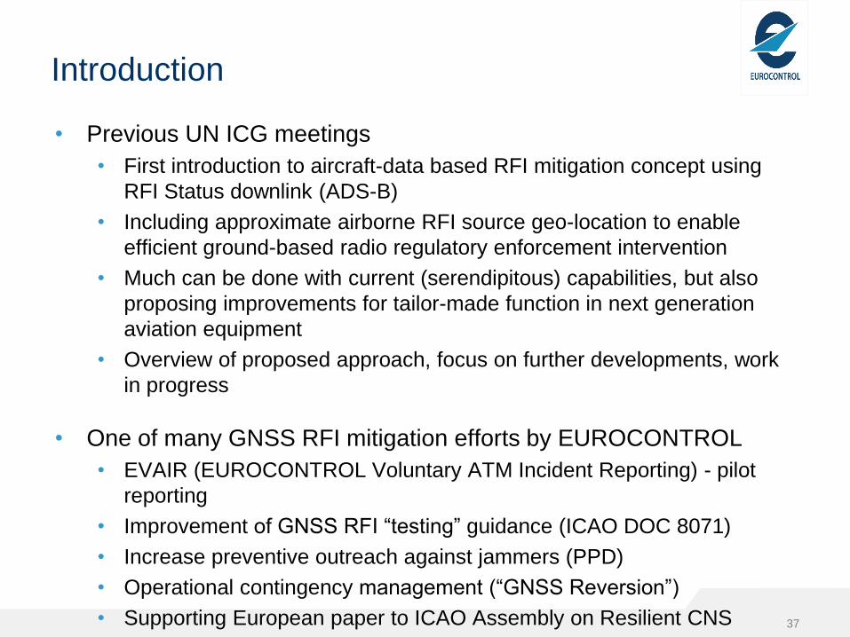
Introduction
• Previous UN ICG meetings
• First introduction to aircraft-data based RFI mitigation concept using
RFI Status downlink (ADS-B)
• Including approximate airborne RFI source geo-location to enable
efficient ground-based radio regulatory enforcement intervention
• Much can be done with current (serendipitous) capabilities, but also
proposing improvements for tailor-made function in next generation
aviation equipment
• Overview of proposed approach, focus on further developments, work
in progress
• One of many GNSS RFI mitigation efforts by EUROCONTROL
• EVAIR (EUROCONTROL Voluntary ATM Incident Reporting) - pilot
reporting
• Improvement of GNSS RFI “testing” guidance (ICAO DOC 8071)
• Increase preventive outreach against jammers (PPD)
• Operational contingency management (“GNSS Reversion”)
• Supporting European paper to ICAO Assembly on Resilient CNS
• Extended conflict zone management of CNS issues
37

3.563.92
3.67 3.52
6.47
3.54 3.84
2.97
3.32 3.16
0
1
2
3
4
5
6
7
2014 2015 2016 2017 2018
Trend with GPS Trend without GPS
No o
f re
port
s p
er
10.0
00 flig
hts
Overall Trend of EVAIR Incident Reports
38
Incident Trend: ---- with GPS Outages ----
without GPS Outages

EVAIR reports - 2018
39
68% of EVAIR AOs’ ATM reports
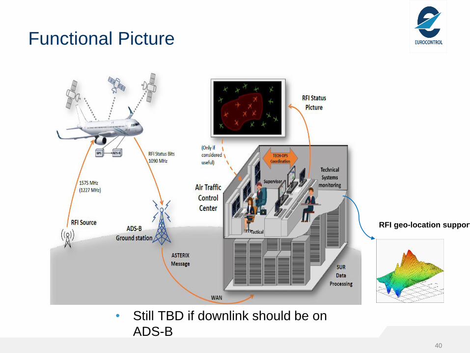
Functional Picture
• Still TBD if downlink should be on
ADS-B40
RFI geo-location support

• Degradation of C/N0 = C/N0 before RFI / C/N0 during RFI
•𝐶/𝑁
𝐶/(𝑁+𝐼)=
𝑁+𝐼
𝑁= 1 +
𝐼
𝑁
• For 5 dB degradation, I = 2,16 N
• For 15 dB degradation, I = 30,6 N
• Noise power for T = 20deg and BW = 2 MHz
• N = kTB = -111dBm
• “Target” RFI Power
• I-5dB = 3,3dB – 111dBm = -107,7 dBm
• I-15dB = 14,8dB – 111dBm = -96,2 dBm
• “Target” FSPL and resulting Distance
• Assumed Jammer Power – FSPL = Target RFI Power
• FSPLGPS L1 = 20 log D + 36,4
• 𝐷 = 10^(𝐹𝑆𝑃𝐿−36,4
20)
Geo-location based on PDOA + RFI level
estimation
41
Power Difference Of Arrival – PDOA
Probability density (2 samples / track gap)
Loose track
Recover track
PL=PR+
5dB

Status report (2 bit)
42
Aircraft
Flight PathState
= 0
State
= 1
State
= 2
State
= 3
C/N
0
-5
dB
C/N0
-15
dB
PO
S
N/A
Assumption: Loss of tracking on
some SV (start of state 2)
corresponds to -15dB C/N0
State 2 may be too close to state
3. But want well-defined interval
between state 1 and 2 which is
not too short
Distance / Flight
Time
D-5 D-15
Estimate for a
variety of
jammer
scenarios used
to derive a useful
update rate
Interferenc
e Source

Assumptions / Unknowns
• Static RFI source
• Omnidirectional RFI
radiation
• No occlusion
• Omnidirectional A/C
antenna pattern
• FSPL attenuation
• C/N0 to RFI level correlation
43
• How accurate is PDOA ?
• Impact of wrong assumptions ?
• Enough to report only 4 states
(only 2 providing useful
information) ?
• Report at fixed intervals or report
transitions?
• How many flights needed for
reasonable geo-location?
• Modelling platform to test
algorithm and assess impact of
different variables
• Use real RFI data for validation

Variables and Metrics
• RFI Location & Power
• Flight paths (straight segments)
• Number of flights
• Aircraft speed
• Uncertainty (noise) in received
RFI
• A/C antenna pattern (modelled
pattern)
• Compensated (FI A/C)
• Not compensated (commercial
A/C)
• RFI level report:
• Real level ( FI A/C)
• 2 bit reports (commercial A/C)
• Sample rate 44
• Location Accuracy : Distance
from actual to predicted
location (probability density
peak)
• RFI power prediction Accuracy
• Ambiguity: Relative “height” of
the first peak
• Roughness: Number of peaks
• Sharpness: Slope of peaks

Ideal scenario
45
• Location: Exact
• Power
prediction: Exact
• Ambiguity: Low
• Roughness:
Depends on #
flights
• Sharpness: high
• Flight paths: 6
• Number of flights: 6
• Aircraft speed: 500
NM/h
• Noise: No
• Radiation pattern:
Omni
• A/C antenna
pattern: Omni
• RFI level report:
Real
• Sample rate: 1 sec
PDOA works in an ideal world !
• Calculation on a lat/long grid
• Probability density derived from
2nd order moment about mean for
Tx power estimates for all samples

Impact of variables
Metrics Loc
Acc
Power
Acc
Ambig
.
Roughn
.
Sharpn. Remarks
Variables
Low sample rate Only for FI A/C
Regular 2 bit
report
Depends on speed; RFI
power
Transition 2 bit
report
Requires high # flights
Noise Comp. by # flights
Rx antenna
pattern
(non
compensated)
May be comp. by flight
paths geometry & A/C
diversity
Rx antenna
pattern
Compensated
Only for FI A/C
Generates secondary
peaks
High A/C speed May compensate noise
High # flight paths
& good geometry
Essential for accuracy
with comm. A/C data
(arrival angle diversity) 46
Beneficial Neutral Low impact Medium
impact
High impact

Poor scenario
47
• Location error:
30NM / first
peak
16NM / second
peak
• Power est. error:
1.5 dB
• Ambiguity: High
• Roughness:
High
• Sharpness: Low
• Flight paths: 6
• Number of flights: 6
• Aircraft speed: 500
NM/h
• Noise: zero mean,
σ=0.5dB
• Radiation pattern:
Omni
• A/C antenna
pattern: Yes (same
all A/C)
• RFI level report:
Transitions
• Sample rate: 1 sec
• Higher number of flight paths /
flights needed to improve location
accuracy
jammer

Real RFI data processing
• Jamming tests executed in cooperation by Skyguide, Swiss Air
Navigation Services Ltd, Swiss Air Force, OFCOM, FOCA, REGA
and Armasuisse.
• Flights: several helicopter and one fixed wing
• Different jamming modes: PRN, CW, Pulsed with 2048 Hz PRF,
Frequency hopping
• Analysis focused on the jamming impact on positioning accuracy
and integrity
• Results presented to ION 2017 GNSS Conference : “Jamming of
Aviation GPS Receivers: Investigation of Field Trials performed with
Civil and Military Aircraft”
• One of the conclusions: “an interference event can be detected
earlier in the range domain by monitoring the average C/N0”
• Our analysis focused on geo-location
• Preliminary analysis of partial data set (only fixed wing flight)48

Flight path and jammer location
49
Hot spot detection. Results from C/N0 level of the satellites in view
Input data
Analysis considers
• Only jammer on time
intervals
• No correlation intervals
discarded
• Actual values (not only level
transitions)
• All jamming modesjammer off
no correlation
C/N0 in time domain (single PRN)

50
Preliminary results
Heatmap for average C/N0 – all SV
Location using average and individual SV C/N0
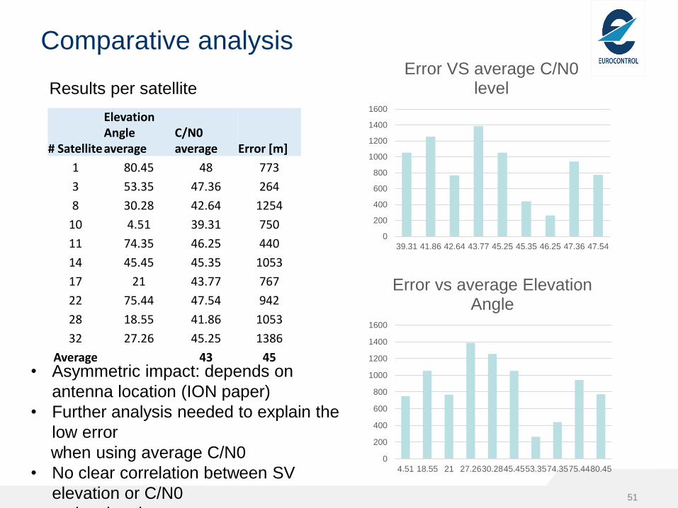
Comparative analysis
Results per satellite
51
# Satellite
Elevation Angle average
C/N0 average Error [m]
1 80.45 48 773
3 53.35 47.36 264
8 30.28 42.64 1254
10 4.51 39.31 750
11 74.35 46.25 440
14 45.45 45.35 1053
17 21 43.77 767
22 75.44 47.54 942
28 18.55 41.86 1053
32 27.26 45.25 1386
Average 43 45
0
200
400
600
800
1000
1200
1400
1600
39.31 41.86 42.64 43.77 45.25 45.35 46.25 47.36 47.54
Error VS average C/N0 level
0
200
400
600
800
1000
1200
1400
1600
4.51 18.55 21 27.2630.2845.4553.3574.3575.4480.45
Error vs average Elevation Angle
• Asymmetric impact: depends on
antenna location (ION paper)
• Further analysis needed to explain the
low error
when using average C/N0
• No clear correlation between SV
elevation or C/N0
and estimation error

Conclusions & Further work
• Potential to detect and locate jammer by C/N0 monitoring confirmed
• Accuracy impacted by various variables
• Further analysis needed to better estimate impact and mitigations
• Improve modelling and test large number of scenarios
• Further analysis of 2 bits & fixed time reporting scenario
• Complete analysis of Swiss data
• Validate modelling using additional real RFI data
• Invitation to UN ICG
• GNSS RFI is increasing in aviation operations and needs proactive
mitigation
• Synergies exist between aviation and non-aviation efforts
• Cooperation with other entities on this topic is highly welcome
• In particular on obtaining useful datasets for validating detection and
geo-localisation methods
52

53
Thank you for
your attention
Acknowledgements:
Skyguide, Swiss Air
Navigation Services Ltd,
Swiss Air Force
OFCOM, FOCA, REGA
and Armasuisse for
making available the
RFI tests dataset

ICG WG-S Intersession Meeting
Potential Discussion at Future WRC
Ispra, Italy
5 to 7 September 2019
Takahiro MITOME (Japan)

Background
• WRC (World Radiocommunication Conference) is held every three to four years and has the job to revise the Radio Regulations, which is the international treaty governing the use of the radio-frequency spectrum. Revisions are made on the basis of agenda, which is determined based on the decisions by previous WRC.
• WRC-19 is going to be held on 28 October to 22 November 2019 and will discuss future WRC agenda items as well.
• Potential impact on RNSS from expected discussion at WRC-19 should be analyzed and necessary preparation should be made by RNSS operators. RNSS operators are encouraged to talk with associated telecommunication administrations for the preparation to WRC-19.
55

Potential Proposal at WRC-19
56
• The study for a possible mobile service allocation in the frequency band 1300-1350 MHz as an agenda item of WRC-23 is going to be proposed from US and other countries at WRC-19. This mobile service is intended to be used for IMT, though it is called “mobile broadband” in the potential US proposal.
• The frequency band 1300-1400 MHz was discussed for IMT in one of WRC-15 agenda items and was removed from the IMT candidate bands in the early stage within WRC-15 cycle because of the potential impact into radars in the same band and RNSS in the adjacent band. From this precedence, it is very likely that the proposed mobile service allocation in the frequency band 1300-1350 MHz would impact on RNSS below 1300 MHz.
• Other proposal for WRC-23 agenda items should also be reviewed from the viewpoint of benefit to RNSS as well as potential impact on RNSS.

Recommended WG-S Actions
57
1) to alert RNSS/GNSS providers about the potential
impacts on possible WRC-23 agenda items, which will be
discussed at WRC-19.
2) to encourage RNSS/GNSS providers to analyze the
potential impact on the operation of RNSS/GNSS below
1300 MHz by the impact from potential mobile service
allocations in the frequency band 1300-1350 MHz, in
particular.
3) based on the above 1) and 2), to encourage
RNSS/GNSS providers to contact their national
telecommunication administration for their national
preparation process for WRC-19, as appropriate.
(WRC-19 Schedule: 28 October-22 November 2019).

58
Backup Slides

Discussion for non-GSO Orbit Parameter Tolerance Limitations in RR
59
• CPM19-2 (February 2019) discussed WRC-19 agenda item 7, issue A (definition of non-GSO bringing into use). Before this meeting, there were proposals to introduce new data item obligations which will request to include specific tolerance to non-GSO orbit parameters, while current ITU practice does not require such tolerance data (in the current practice of ITU, the need of non-GSO orbit parameter tolerance is discussed only in the bilateral coordination). (NOTE: This was reported at ICG-13 in November 2018.)
• In the discussion at CPM19-2, the impact into RNSS from potential restriction of non-GSO orbit parameters was discussed. The output from CPM19-2 (CPM19-2 Report to WRC-19) does not include the option to restrict the range of non-GSO orbit parameters.
• Even without options in CPM19-2 Report to WRC-19, some administrations may try to propose this idea at WRC-19 directly. Thus, it is still encouraged to watch WRC-19 agenda item 7, issue A.

International Committee on GNSS (ICG)Working Group - Systems, Signals and Services
Compatibility and Spectrum Sub-Group Report
Ispra, Italy
5 to 7 September 2019
Takahiro MITOME (Japan), Dominic HAYES (EC)
Co-Chairs of Compatibility and Spectrum Sub-Group

Objectives of Compatibility and Spectrum Sub-Group
• Compatibility issues and information sharing regarding the protection of GNSS spectrum from interference from other radio services, as well as IDM issues;
• Document agreed results in the form of findings, reports, or whatever form may be appropriate for the case;
• Provide proposals to WG-S on compatibility issues, for discussion and decision.
61

62
ICG-10 Recommendation #1: Campaign on Protection of RNSS Operations
62
• The third RNSS spectrum protection seminar was held during UN GNSS Workshop in June 2019 in Fiji.
• This seminar audience had diverse backgrounds, different to those from the past seminars held in December 2015 in Austria, December 2016 in Nepal, and March 2018 in Argentina. As such the importance of RNSS spectrum protection was more broadly disseminated.
• Thus, ICG's outreach that aims to inform decision makers about the importance of GNSS spectrum protection is being successfully conducted. The sub-group agreed to continue this activity and also discussed preparation of a summary report of the seminars for wider distribution.

63
ICG-10 Recommendation #1: Campaign on Protection of RNSS Operations
• Materials from the June 2019 GNSS Workshop can be found here:http://www.unoosa.org/oosa/en/ourwork/psa/schedule/2019/2019-workshop-IDM_-presentations.html
• The Spectrum Seminar materials include;
–Fundamentals of GNSS
–Interference Threats
–Interference and Spectrum Management
–Current Interference Challenges; Jammers, Adjacent Band Compatibility
The Expert Team is considering capturing the presentation material in a booklet

DRAFT ICG-14 RECOMMENDATION 14S-1
[Recognizing;
• To be completed]
Recommends;
• that the WG-S Compatibility and Spectrum subgroup, in
coordination with the ICG Secretariat, produce a draft booklet
on GNSS/RNSS Spectrum Protection based on the briefing
material used for the ongoing spectrum seminars:
• Fundamentals of GNSS
• Interference and Spectrum Management
• Interference Threats
• [Methods of Interference Detection and Mitigation]
• [Current Interference Challenges]
• that the ICG consider formal endorsement of the draft booklet at
a future meeting

65
GNSS Interference Detection
65
• The sub-group discussed the use of raw data from GNSS chipsets which is now accessible on Android devices (still unclear on Apple devices)
• The sub-group was also informed about the EU's work to promote this capability - GNSS raw measurement task force.
• The sub-group discussed other possible raw data outputs that would improve capabilities and ways to encourage manufacturers to make them available
• In response to Rec. 12S-2, the sub-group also discussed ways such raw GNSS data might be used to benefit national interference detection systems
• The sub-group discussed the Eurocontrol’s trail for RFI Downlink using ADS-B to report the RFI incidence.
• The sub-group recognized Eurocontrol is welcoming possible cooperation with other entities, expecting synergies between aviation and non-aviation efforts.
Devise-Based GNSS Interference Detection -Crowed Source-
RFI Downlink – ADS-B -
Testing Approval Public Notification
66
• The sub-group received a presentation titled “GPS Interference Test Approval Process”.
• The sub-group agreed to consider the proposed draft ICG Recommendation “Testing Approval Public Notification”
• To review this proposed ICG Recommendation, each provider should provide how this proposed process will work in their countries, in particular regarding interagency discussion framework, treatment of testing activities and involvement of telecommunication administration.
• The sub-group also discussed that non ICG members (countries which do not have GNSS providers) may be difficult to implement this proposed process. Thus, the details of the draft ICG Recommendation should be reviewed further.

8th IDM Workshop related Proposal
67
• 8th IDM Workshop was held on 14 May 2019 in Baska, Croatia and discussed the following presentations;• Development and Operation of a GPS Jammer
Localization System at Incheon International Airport• Measurement Test of Purchased Radio Equipment
- Short Range Device -• Interference from Amateur Services to GNSS within
the 1260-1300 MHz band• Project Introductions: GNSS Interference Detection
and Localization in the City• Systematization of Information on Various Types of
GNSS Receivers and Various Types of Interference• GNSS RFI Status Downlink• Actual Question of Monitoring in the Navigation
Situation

Ongoing WG-S Action
Protection RNSS Spectrum from non-RNSS Sources
Background:
There are many studies to protect/quantify the interference into RNSS
spectrum from other RF sources.
Thus, it would be worthwhile to summarize these available information
comprehensively.
WG-S Action - to continue work on summarizing the available information
on the following issues:
- Acceptable levels of protection from interference and measurement
methods
- Monitoring of interference environment
- Identification of interference sources
- Recommendations on the elimination/minimization of interference
impact.Regarding the following two presentations at 8th IDM workshop, the sub-
group agreed to invite ICG members to make comments on them prior to
the ICG-14 meeting in December 2019:
- “Systematization of Information on Various Types of GNSS Receivers and Various Types of
Interference ” Dmitry Aronov, Egor Zheltonogov, Geyser-Telecom, Ltd., Russian Federation
- “Аctual Question of Monitoring in the Navigation Situation“ Sergey Silin, NAVIS Inc., Russian
Federation
Background:
There are many studies to protect/quantify the interference into RNSS
spectrum from other RF sources.
Thus, it would be worthwhile to summarize these available information
comprehensively.
WG-S Action - to continue work on summarizing the available information on
the following issues:
- Acceptable levels of protection from interference and measurement methods
- Monitoring of interference environment
- Identification of interference sources
- Recommendations on the elimination/minimization of interference impact.
Ongoing WG-S Action
Protection RNSS Spectrum from non-RNSS Sources

Ongoing WG-S ActionProtection RNSS Spectrum from non-RNSS Sources (2)
69
• Under the auspices of the Compatibility & Spectrum subgroup, the IDM Task Force and spectrum compatibility experts will jointly consider the relationship between the EU STRIKE3 report and the on-going work by Russian Experts for “Practical assessment of electromagnetic and interference environment at the measurement point in GNSS frequency bands” on characterizing and measuring the RNSS spectrum environment.
• Recognizing the almost identical document was approved by ITU-R Study Group 1 and now become Report ITU-R SM.2454 “Spectrum monitoring techniques in the radionavigation-satellite service frequency bands”, the IDM Task Force and the subgroup will also be invited to consider the content of this ITU-R Report together with the comments on this ITU-R Report from RNSS experts in ITU-R WP 4C.

Proposed WG-S Action from Intersession Meeting in September 2019
70
1) to alert RNSS/GNSS providers about the potential impacts
(including impact from unwanted emission) on all potential WRC-23
agenda items, which will be discussed at WRC-19. The following are
currently identified for action;
- to recognize the European Common Proposal to WRC-19
regarding WRC-23 agenda item, “to review the amateur service
secondary allocation in the 1 240-1 300 MHz frequency band to
determine if additional measures are required to ensure the
protection of the RNSS in the same band”
- to encourage RNSS/GNSS providers to analyze the potential
impact on the operation of RNSS/GNSS below 1300 MHz by the
impact from potential mobile service allocations in the frequency
band 1300-1350 MHz, in particular.
2) based on the above, to encourage RNSS/GNSS providers to
contact their national telecommunication administration for their
national preparation process for WRC-19, as appropriate.
(WRC-19 Schedule: 28 October-22 November 2019).

71
GNSS Interference Detection
71
• The sub-group discussed the use of raw data from GNSS chipsets which is now accessible on Android devices (still unclear on Apple devices)
• The sub-group was also informed about the EU's work to promote this capability - GNSS raw measurement task force.
• The sub-group discussed other possible raw data outputs that would improve capabilities and ways to encourage manufacturers to make them available
• In response to Rec. 12S-2, the sub-group also discussed ways such raw GNSS data might be used to benefit national interference detection systems
• The sub-group discussed the Eurocontrol’s trail for RFI Downlink using ADS-B to report the RFI incidence.
• The sub-group recognized Eurocontrol is welcoming possible cooperation with other entities, expecting synergies between aviation and non-aviation efforts.
Devise-Based GNSS Interference Detection -Crowed Source-
RFI Downlink – ADS-B -

ICG-12 RECOMMENDATION 12S-1Recognizing;
a) Recommendations ITU-R M.1902, 1903, 1905 contain protectioncriteria for RNSS from non-RNSS sources
b) that the interference protection criterion of C/No degradation of 1 dB(equivalent to I/N of -6 dB) is used for the Adjacent BandCompatibility assessment in one country;
c) that existing studies regarding interference from unwanted emissionsuse protection criteria referenced in recognizing a);
d) that the criterion in the above recognizing b) is consistent with theprotection afforded by the application of Recommendations inrecognizing a),
Recommends;
that ICG members should encourage national regulators to use theprotection criteria in the relevant ITU-R Recommendations in recognizinga), in order to protect GNSS from non-RNSS interference sources,including unwanted emissions.

Implementation of Recommendation 12S-1
• Japan – prior to the ICG recommendation, ITU-R M.1902, 1903, 1905 were already being used as the basis for RNSS spectrum management
• EU – interference protection criterion of C/No degradation of 1 dB (equivalent to I/N of -6 dB) has been used as the basis for the ETSI standard associated with the Radio Equipment Directive (RED) applicable to GNSS receivers sold in the EU
• [China - ITU-R M.1902, 1903, 1905 should be used to protect critical uses of GNSS]
• Russia – National regulator has been informed of the ICG recommendation
• USA – Spectrum regulators are aware of the ICG recommendation
• India – To be submitted before ICG-14

INTEROPERABILITY & SERVICE
STANDARDS
Co-chairs
Xiaochun LU, China
Jeff AUERBACH, U.S.

Interoperability & Service Provision Subgroup
Jeff Auerbach, U.S. - Co-lead Xiaochun LU, China - Co-lead
China
Shuli SONG
Juan DU
Jun SHEN
Jianwen LI
European Union
Hillar Tork
Peter Buist
Werner Enderle
Joerg Hahn
Japan
Satoshi Kogure
Masaharu Kugi
U.S.
Robyn Anderson
John Lavrakas
Andrew Hansen
Russia
Igor Larin
Tatyana Mirgorodskaya
Alex Bolkunov
Igor Silvestrov
Tatiana Primakina
Andrey Druzhin
Sergey Silin
India
N M Desai
R. Ramasubramanian

Workshop Summary Slides
ICG Performance Standards & IGMA Workshop
Hosted by United States Delegation
United Nations Office in Vienna
June 12 & 13, 2019

IGMA Task Force
• “Open” meeting on June 12
• Attended by China, Europe, IGS, Japan, Russia, and United States
• IGMA Joint Trial Project –• Presentations by China, Europe, IGS, Japan, Russia, and United States• Described methodologies used in the their trial project monitoring system• Provided trial project status
• “Closed” meeting on June 13 for Task Force members• Trial Project Results
• Results of orbit/clock errors, user range error, PDOP, and UTC offset error• Presentations by China, Europe, IGS, Russia, and United States• The document “Summary on Methodology of GNSS Monitoring and Assessment for ICG
IGMA-IGS TJP” was discussed and the column identified as “Recommend” was completed, which provides the final harmonized statement for each of the parameters.
• Next steps –• Update IGMA Trial Project Methodologies document• Standardize time and grid selections; meet again to compare results• Russia to host workshop in Spring 2020

Performance Standards Dream Team• “Open” Meeting on June 12
• Attended by China, Europe, Japan, Russia, and United States
• Performance Standards Definitions• Update was proposed to PS Guidelines to make the
standards for Range Availability Optional and Slot Availability Key
• Next steps –• Share hints & tips; harmonize calculation methods• Consider updates to PS Guidelines• Russia to host workshop in Spring 2020

ESA UNCLASSIFIED - For Official Use
Using Broadcast versus Estimated GGTO in Harsh Environments
F.Melman, P.Crosta, X.Otero, R.Lucas
ICG WG-S, Intersessional Meeting06 September 2019, ISPRA, Italy
ESA UNCLASSIFIED - For Official Use ICG WG-S Intersessional Meeting | 06/09/2019 | Slide 81
Background
• At the June 2019 Timing Workshop, the point was made that the broadcast values of XYTO* should be
used only when the number of satellites available prevents its determination.
• Feedback received from a well-known manufacturer of mass-market GNSS chips indicate that although
opportunistically they can compute XYTO, they still would like a reliable and accurate broadcast value. They
also reported that their receiver biases are well calibrated already.
• A mass-market user is exposed to harsh environments (i.e urban) where measurements are polluted with
multipath errors (LOS and NLOS) impacting the XYTO estimation and the PVT.
• The majority of the users operate in harsh environments.
• This presentation addresses the above issue comparing the impact on the PVT of using the broadcast
GGTO versus estimating its value on the receiver.
*XYTO = Inter-System Time Offsets,e.g. via GGTO, via UTC broadcast, ….

ESA UNCLASSIFIED - For Official Use ICG WG-S Intersessional Meeting | 06/09/2019 | Slide 82
Test Setup (Professional Receiver)
Test Setup
Date 7 July 2018
Duration 12:30:00 – 14:30:00 (2 hours)
Constellation GPS + Galileo
Elevation Mask 5 degrees
Smoothing Carrier Phase Based Hatch Filter
PNT algorithm Weighted Least Squares
Receiver Professional Antenna + Receiver
Environment Open Sky (15 minutes) -> Urban (1:45 hr)

ESA UNCLASSIFIED - For Official Use ICG WG-S Intersessional Meeting | 06/09/2019 | Slide 83
3D-Position Error (Professional – Static – Open Sky)
ESA UNCLASSIFIED - For Official Use ICG WG-S Intersessional Meeting | 06/09/2019 | Slide 84
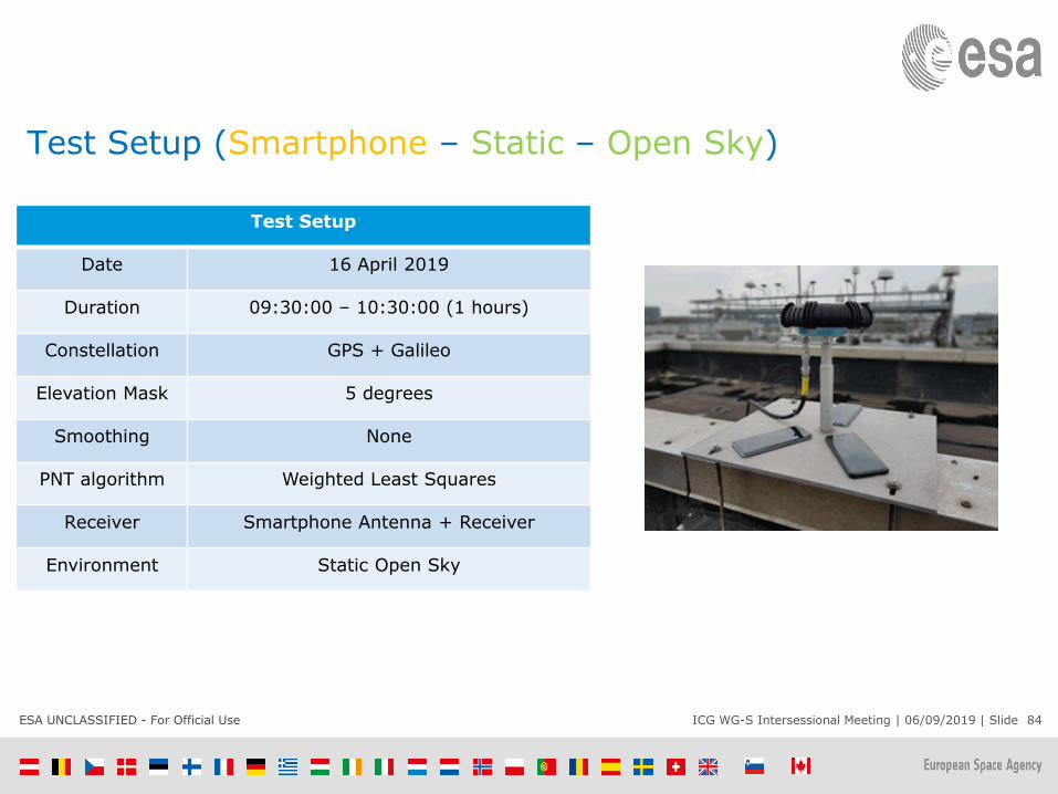
Test Setup (Smartphone – Static – Open Sky)
Test Setup
Date 16 April 2019
Duration 09:30:00 – 10:30:00 (1 hours)
Constellation GPS + Galileo
Elevation Mask 5 degrees
Smoothing None
PNT algorithm Weighted Least Squares
Receiver Smartphone Antenna + Receiver
Environment Static Open Sky

ESA UNCLASSIFIED - For Official Use ICG WG-S Intersessional Meeting | 06/09/2019 | Slide 85
3D-Position Error (Smartphone – Static – Open Sky)

ESA UNCLASSIFIED - For Official Use ICG WG-S Intersessional Meeting | 06/09/2019 | Slide 86
3D-Position Error (Professional – Dynamic - Urban)

ESA UNCLASSIFIED - For Official Use ICG WG-S Intersessional Meeting | 06/09/2019 | Slide 87
3D-Position Error (Professional Receiver) - Snapshot

ESA UNCLASSIFIED - For Official Use ICG WG-S Intersessional Meeting | 06/09/2019 | Slide 88
3D-Position Error (Professional Receiver) - Snapshot
G08
G10
G27
E09
• 7 satellites are tracked by Rx and used by PVT• G11 - G16 - G28 -> Out-of-view of the camera
High Residuals -> Multipath
ESA UNCLASSIFIED - For Official Use ICG WG-S Intersessional Meeting | 06/09/2019 | Slide 89
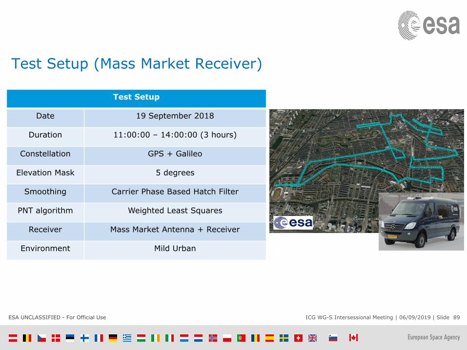
Test Setup (Mass Market Receiver)
Test Setup
Date 19 September 2018
Duration 11:00:00 – 14:00:00 (3 hours)
Constellation GPS + Galileo
Elevation Mask 5 degrees
Smoothing Carrier Phase Based Hatch Filter
PNT algorithm Weighted Least Squares
Receiver Mass Market Antenna + Receiver
Environment Mild Urban
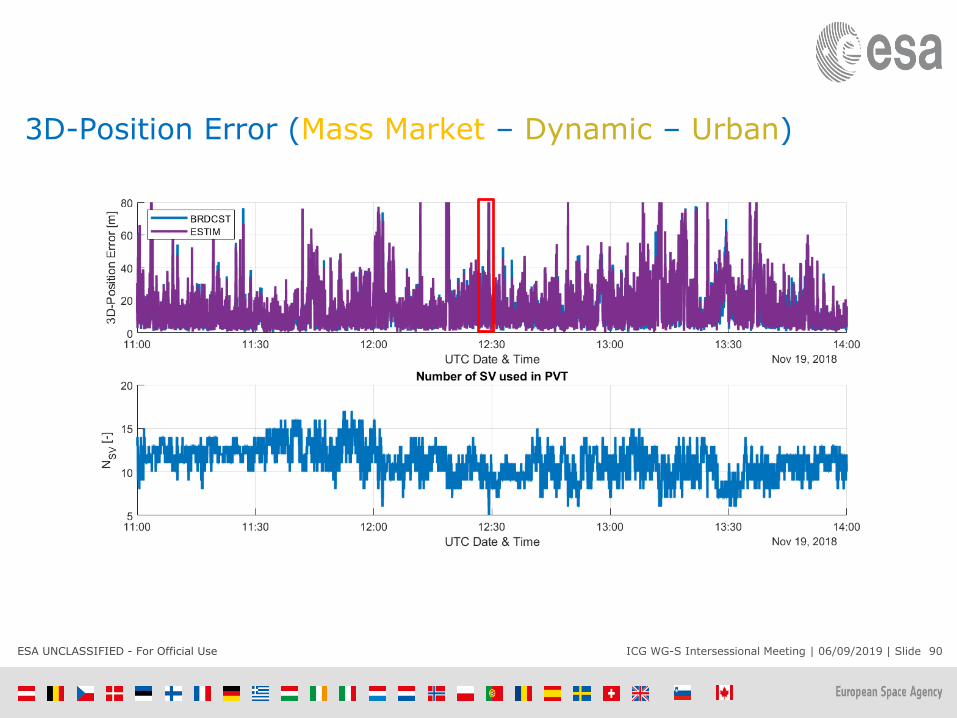
ESA UNCLASSIFIED - For Official Use ICG WG-S Intersessional Meeting | 06/09/2019 | Slide 90
3D-Position Error (Mass Market – Dynamic – Urban)

ESA UNCLASSIFIED - For Official Use ICG WG-S Intersessional Meeting | 06/09/2019 | Slide 91
3D-Position Error (Mass Market) - Snapshot
ESA UNCLASSIFIED - For Official Use ICG WG-S Intersessional Meeting | 06/09/2019 | Slide 92
Static Open Sky Position Performance
• For the professional receiver it appears to be better to use estimated GGTO, mainly due to
the accuracy of the broadcasted GGTO at that time.
• For the smartphone receiver there appears to be no difference (benefit) of using the
estimated GGTO.
• In the smartphone the accuracy of the solution is dominated by the errors in the
measurements and the accuracy of the broadcasted GGTO does not have an impact.

ESA UNCLASSIFIED - For Official Use ICG WG-S Intersessional Meeting | 06/09/2019 | Slide 93
Dynamic Urban Position Performance
• In good visibility cases:
• Professional receiver: better GGTO estimation compared with broadcast but no
large difference in PVT error, which appear to be bounded by the broadcast GGTO
accuracy.
• Mass-Market Receiver: No significant difference between using estimation of GGTO
or its broadcast.
• In poor visibility cases (deep urban canyon) the estimated GGTO has large error
peaks while the broadcast GGTO is more accurate. This is the case for both, professional
and mass market receivers.
• Overall, using the broadcasted GGTO brings a significant benefit compared to
estimated GGTO.
ESA UNCLASSIFIED - For Official Use ICG WG-S Intersessional Meeting | 06/09/2019 | Slide 94
Conclusions
• The results of short tests using mass market and professional receivers appear to confirm
the view of the mass-market GNSS chip manufacturer.
• The use of broadcast XYTO vaues (e.g. GGTO for GPS and Galileo) brings benefits to a
majority of users (e.g. smartphones) when compared to the use of only an estimation of XYTO
in the receiver.
• ICG WG-S is encouraged to continue its work in defining the optimum way of computing
and disseminating XYTO, focusing in particular to the benefits provided to mass-market users
in harsh environments:
• A workshop with representatives of mass-market GNSS receivers/chips may be an adequate way
to advance in understanding their needs and requirements with regard to XYTO.
• Experimental work using offsets with respect to UTC prediction as pivot for XYTO, in conditions of
mass-market users, is recommended.

Timing Workshop Results - RussiaAfter the discussion the following directions of ICG WG S Time
interoperability activities were proposed:
1. Providers are to indicate in their ICDs and/or other basic documents
that for calculating GNSS-GNSS Time offset by multi-system users the
broadcast GGTO corrections should be used only in case it is impossible
to calculate the offset in the autonomous mode due to the lack of SVs in
view.
2. Interoperability and Service Standards Sub-group is to shift the focus of
its attention to time transfer problems.
3. The members of ICG WG S and WG D are to present the results of
GNSS Time Interoperability analysis and GNSS-GNSS time offsets to
ICG 14.
4. ICG IGMA Task Force is to consider GNSS-GNSS Time offset as one of
Monitoring parameters.
5. IGS GNSS Monitoring Working Group is asked to present the results of
their activity at ICG Annual Meetings and intersessional WG S/ WG D
meetings.

ICG WG-S and WG-DTiming Workshop
14 June 2019
96
Conclusions and Actions

WG-S/WG-D Timing Workshop – June 2019
1. Background and Previous Actions – Interoperability Subgroup
Co-Chairs
2. GLONASS Time and GNSS Time Interoperability – Russia
3. Interoperability through accurate prediction of [GNSS time
– UTC] – BIPM
4. Different ways of estimating the GGTO, and their impact
on the position accuracy – Royal Observatory of Belgium
5. The new results of GNSS Time Offsets Monitoring and the
Opinion about MGET and xGTO – China
6. Progress on Multi-GNSS Timing Offsets: XGTO, MGET –ESA
7. Considerations on GNSS Timescale Offsets – BIPM

GNSS Timing Workshop – Conclusions
[CONCLUSION 1: The single station time offset monitoring technique, as presented by China at the Workshop, is currently being implemented by all GNSS providers]
98

China Presentation - Timing Workshop (1)

China Presentation - Timing Workshop (2)

GNSS Timing Workshop – Conclusions
CONCLUSION 2: No consensus among ICG for establishing a task force to examine the XGTO and MGET proposals using live signals, as proposed by ESA –Agreement that no further discussion is warranted at this time
101
GNSS Timing Workshop – Actions
ACTION 1: Estimation of the GNSS time offset is best accomplished by estimation within the individual user receiver. Providers should try to ensure that GNSS receiver manufactures understand this and only use the broadcast GGTO values when internal receiver estimation is not available. Where appropriate include guidance in user ICD, performance specifications, best practices guides, etc…
ACTION 2: The IGMA Task Force will consider including time offset monitoring under the ICG/IGS Trial Project
ACTION 3: IGS will provide a briefing at ICG-14 on what the IGS Timing Subgroup is and what it produces and provide future updates as necessary
102

Ispra, Italy5-7 September 2019
ICG Working Group on Systems
Signals and Services (WG-S)2019 Intersessional Meeting
Interoperability and Service Provision Subgroup Report

Interoperability & Service Provision Subgroup
Jeff Auerbach, U.S. - Co-lead Xiaochun LU, China - Co-lead
China
SONG Shuli
DU Juan
SHEN Jun
LI Jianwen
European Union
Hillar Tork
Peter Buist
Werner Enderle
Joerg Hahn
Japan
Satoshi Kogure
U.S.
Bethany Kroese
John Lavrakas
Andrew Hansen
Russia
Igor Larin
Tatyana Mirgorodskaya
Alex Bolkunov
Igor Silvestrov
Tatiana Primakina
Andrey Druzhin
Sergey Silin
104

Interoperability and Service Standards
• Open service Information Sharing and standards
development
• Each Provider will strive to publish and disseminate all signal and
system information necessary to allow manufacturers to design
and develop GNSS receivers
• Develop common terminology and definitions in individual GNSS
Open Service Signal Specifications and Performance Standards
• User level Multi-GNSS Interoperability and Use
• Interoperability definition adopted at the first Providers Forum
meeting and updated at the third meeting
• Focus on the open service signal development and broadcast
plans of the system providers
• Consider the role of system time and geodetic reference frames
in enabling interoperable multi-GNSS service
105
OPEN SERVICE INFORMATION SHARING
106

Work Plan - Open Service Performance Standards
• Consistent with the principle of transparency in the provision of open services, each individual Provider will strive to publish and disseminate all signal and system information necessary to allow manufacturers to design and develop GNSS receivers.
• The Subgroup will develop a template to promote common terminology and definitions in individual GNSS Open Service Signal Specifications as published in Interface Standards and Interface Control Documents.
• The Subgroup will also develop a template that each individual GNSS provider may consider using in their publication of signal and system information, the policies of provision, and the minimum levels of performance offered for open services used on the Earth and in outer space (Open Service Performance Standards).
107

Sub-Group Members focused on Performance Standards – Dream Team
• Alexey Bolkunov (co-lead), Igor Silvestrov, Sergey Kaplev - Russian Federation
• John Lavrakas (co - lead), Andrew Hansen -United States
• Hillar Tork, Rafael Lucas-Rodriguez, Daniel Blonski, Peter Buist - European Union
• Yoshihiro Iwamoto, Masaharu Kugi, Satoshi Kogure - Japan
• Jianwen LI, Juan DU – China
• R. Ramasubramanian - India

Status of GNSS ICDs and Open Service Performance Standards
GPS GLONASS BDS Galileo NavIC QZSS
Interface Control Documents/Specifications
✓ ✓ ✓ ✓ ✓✓
IS GPS 200-H, 705D, 800D
ICD 5.1 for L1&L2 FDMA
(2008)ICD 1.0 for L1, L2&L3 CDMA
(2017)
ICD 2.1Open
Service signals B1C
& B2a(test version)
ICD 1.3 ICD 1.0
IS-QZSS-PNT-001
IS-QZSS-L1S-001
IS-QZSS-L6-001
IS-QZSS-TV-001
(‘4 of 5 Svs.)
Open Service PerformanceStandards
✓ Draft for
L1&L2 service
is in approval
stage
✓ Galileo OS Service Definition Document v1.0Dec 2016
✓
SPS PS 4th
edition (L1-only)
English DraftProvided to
WG
OS PS 1.0 PS-QZSS-001
Web Access GPS.gov GLONASS-IAC.RU
en.beidou.gov.cn/
gsc-europa.eu
irnss.isro.gov.in/
qzss.go.jp/en/ technical/ps-is-qzss/ps-is-qzss.html
109

Roadmap & Scorecard – GNSS Performance Standards Guidelines – to be updated
Item Status Comments
Recommend draft content for Performance Standards Complete Draft Performance Standard Template
prepared and provided in 2012 (DDST-2012)
Draft Calculation Methods applicable with DDST-2012 Complete Draft Calculations Methods Document
prepared and provided in 20145
Collect inputs on minimum common set Complete Survey conducted in Dec 2016
Finalize minimum common set Complete Resolved at Sep 2017 meeting
Each GNSS/RNSS provide definitions for terms In progress Ongoing. Discussed on monthly
teleconference calls (MTC)
Each GNSS/RNSS identify calculation methods In progress Ongoing. Discussed on MTCs
Finalize set of definitions In progress Ongoing
Issue Performance Standard Guideline Document
(“Guidelines for Developing Performance Standards”)
Complete Recommendation for WG-S and ICG-13
Set of Calculation Methods used in PSs and SDDs Under discussion To be discussed on MTCs and ICG-13
Hints and Tips on PSs and SDDs (or their new revisions)
development and parameters estimation and evaluation
Under discussion To be discussed on MTCs and ICG-13
Calculation methods Guidelines Under discussion To be discussed on MTCs and ICG-13
Further tasks and challenges, including maintaining of
issued documents
Under discussion To be discussed on MTCs and ICG-13

Performance Standards Workshop – June 2019
• “Open” Meeting on June 12
• Attended by China, Europe, Japan, Russia, and United States
• Performance Standards Definitions
– Update was proposed to PS Guidelines to make the standards for Range Availability Optional and Slot Availability Key
• Next steps –
– Share hints & tips; harmonize calculation methods
– Consider updates to PS Guidelines
– Russia to host workshop in Spring 2020

PERFORMANCE MONITORING
112

IGMA Task Force
• Co-Chairs:
– Satoshi Kogure, CAO, Japan
– Shuli SONG, China
– Allison Craddock, IGS
• Members:
– Igor Silvestrov, Alexey Bolkunov, Russia
– LI Jianwen, China
– Yoshihiro Iwamoto, Japan
– Karen Van Dyke, John W. Lavrakas, Andrew J.
Hansen, United States
– Hillar Tork, Werner Enderle, Peter Buist, European
Union
113

Work Plan – Service Performance Monitoring
• The Providers Forum has agreed to consider the development and discussion of proposals to widely monitor the performance of their open signals and provide timely updates to users regarding critical performance characteristics such as timing accuracy, positioning accuracy and service availability
• The Working Group, through the Interoperability and Service Standards Subgroup, will support this activity by translating open service performance standards into parameters for multi-GNSS monitoring. Recommendations on the necessary monitoring infrastructure and organizational approaches may be made to Providers and international organizations in coordination with other ICG working groups as necessary and appropriate
114

Existing Civil Service Monitoring Information Sources
Name Country URL
Information Analysis
Center
Russia http://glonass-iac.ru/en/
US Coast Guard
Navigation Center
William J. Hughes
Technical Center WAAS
Test Team
U.S. http://www.gps.gov/
European GNSS Service
Centre
EU http://www.gsc-europa.eu/
CSNO TARC China http://www.csno_tarc.com
QZ-vision Japan http://sys.qzss.go.jp/dod/en/
India
IGS portal IGS http://igs.org/
115

Providers’ Nomination Status SUMMARY Country Signed CL Category Organization Name
Russia X MAC PNT Center in TSNIMASH
Monitoring
site(2)
Klyuchi, Korolyov
Data Center PNT Center in TSNIMASH
U.S. X MAC DOT/Volpe Center
Monitoring
site(6)
Boston, Honolulu, Los Angels, Miami, Juneau, and
Merida
Data Center USCG
EU X MAC GSA/Galileo Reference Centre
Monitoring site To be provided
Data Center To be provided
China X MAC RISM/NTSC
Monitoring
site(3)
Shanghai, Lhasa, and Urumqi
Data Center TARC/CSNO
Japan To be provided To be provided116
IGMA Activities and Progress

IGMA Workshop – June 2019
• “Open” meeting on June 12
• Attended by China, Europe, IGS, Japan, Russia, and United States
• IGMA Joint Trial Project –– Presentations by China, Europe, IGS, Japan, Russia, and United States
– Described methodologies used in the their trial project monitoring
system
– Provided trial project status
• “Closed” meeting on June 13 for Task Force members
– Trial Project Results
• Results of orbit/clock errors, user range error, PDOP, and UTC offset error
• Presentations by China, Europe, IGS, Russia, and United States
• The document “Summary on Methodology of GNSS Monitoring and
Assessment for ICG IGMA-IGS TJP” was discussed and the column
identified as “Recommend” was completed, which provides the final
harmonized statement for each of the parameters.

IGMA Task Force
• Next steps –
– Update IGMA Trial Project Methodologies
document
– Standardize time and grid selections; meet again
to compare results
– Russia to host workshop in Spring 2020

TIMING INTEROPERABILITY
119

Work Plan - Interoperability
• As with the principle of compatibility, the principle of interoperability and its definition was adopted at the first Providers Forum meeting and updated at the third meeting. Consistent with this principle and its definition, the working group, through a subgroup co-chaired by the United States and China, will consider the perspective of various user applications and equipment manufacturers, and will:
• Continue efforts to interact with industry experts and user community representatives in order to solicit input on improving the overall open service provided by global and regional navigation satellite systems in a manner that allows for effective multi-GNSS use at the user level;
• Maintain a focus on the open service signal development and broadcast plans of the system providers; and,
• In cooperation with Working Group D, consider the role of system time and geodetic reference frames in enabling interoperable multi-GNSS service
120

WG-S/WG-D Timing Workshop – June 2019
1. Background and Previous Actions – Interoperability Subgroup
Co-Chairs
2. GLONASS Time and GNSS Time Interoperability – Russia
3. Interoperability through accurate prediction of [GNNS time
– UTC] – BIPM
4. Different ways of estimating the GGTO, and their impact
on the position accuracy – Royal Observatory of Belgium
5. The new results of GNSS Time Offsets Monitoring and the
Opinion about MGET and xGTO – China
6. Progress on Multi-GNSS Timing Offsets: XGTO, MGET –ESA
7. Considerations on GNSS Timescale Offsets – BIPM

2019 GNSS Timing Workshop – Conclusions
• [CONCLUSION: The single station time offset monitoring technique, as presented by China at the Workshop, is currently being implemented by all GNSS providers]
• CONCLUSION: No consensus among ICG for establishing a task force to examine the XGTO and MGET proposals using live signals, as proposed by ESA – Agreement that no further discussion is warranted at this time
122
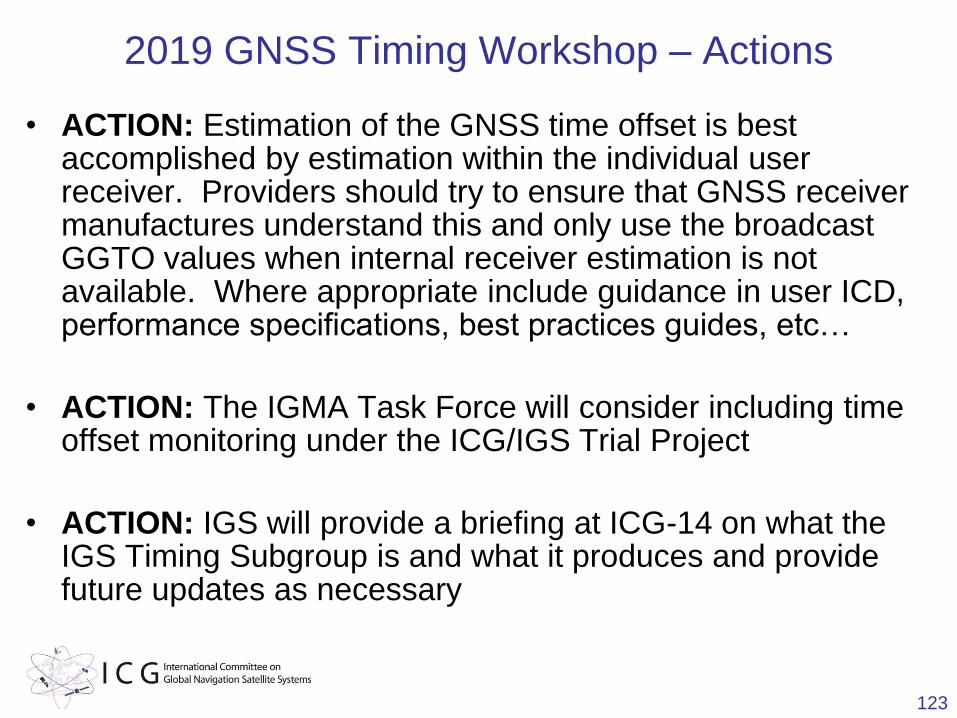
2019 GNSS Timing Workshop – Actions
• ACTION: Estimation of the GNSS time offset is best accomplished by estimation within the individual user receiver. Providers should try to ensure that GNSS receiver manufactures understand this and only use the broadcast GGTO values when internal receiver estimation is not available. Where appropriate include guidance in user ICD, performance specifications, best practices guides, etc…
• ACTION: The IGMA Task Force will consider including time offset monitoring under the ICG/IGS Trial Project
• ACTION: IGS will provide a briefing at ICG-14 on what the IGS Timing Subgroup is and what it produces and provide future updates as necessary
123

Timing Interoperability Tasks to Subgroup
1. Reach consensus on conclusions and actions from June 2019 workshop by [October 4, 2019]
2. Propose next steps to WG-S at ICG-14
– Conduct another workshop or seek alternative approaches to investigate time interoperability?
– Other actions?
3. Discuss the conclusions from ESA presented at the intersessional meeting

PPP INTEROPERABILITY
125

PPP Interoperability
• Interoperability and Service Provision Subgroup Meeting, June 2019 in Vienna
– Discussion about PPP interoperability as a topic of future discussion within the Subgroup
• Agreement that this is a topic of interest to Subgroup members
• PPP Workshop, June 2019 in Fiji
– Chaired by WG-D with participation from WG-S and WG-B
– Attendees included representatives from: Australia, China, Japan, EU, Russian Federation, U.S., FIG and IGS
– Focused on understanding proposed designs from service providers and discussing next steps
126

PPP Workshop –Recommendations/Outcomes
• Recommendation 1: Consider involving/discussing with the SBAS Interoperability Working Group and the ICAO Navigation Systems Panel moving forward
• Recommendation 2: Concentrate on establishing the foundational documents, and baseline language to develop a common language on the basic parameters, etc. – WG-D Proposal: Publish and disseminate PPP signal and system information
• Recommendation 3: Consider establishing a task force within the Interoperability Subgroup
• Recommendation 4: WG-S should consider a draft recommendation for discussion and approval at their intersessional meeting in September 2019
127

PPP Workshop –Recommendations/Outcomes
• Recommendation 5: In preparation for the WG-S intersessional, the group should develop questions to stimulate discussion in WG-S intersessional meeting in September and also to highlight the importance to develop such foundational documents to PPP services. It is also recommended that providers should consider the questions and prepare a response for the WG-S intersessional meeting.
128

PPP Questions for WG-S Consideration
1. During the Joint WG‐S/‐B/‐D workshop in Fiji, the participating experts recognized the importance of “Interoperability of Precise Point Positioning (PPP) Services”. Is this finding shared and therefore worthy of further discussion and cooperation within the ICG? (Yes/ No)
2. If “Yes”, how can this be achieved? Is the current multi‐WG team of experts under the umbrella of the Interoperability Sub‐group of WG‐S a suitable setup? (Yes/ No)
3. Should in the ICG WG’s (S/B/D) experts work towards a roadmap detailing the activities aimed at interoperability and compatibility of PPP service providers?
129

PPP Questions for WG-S Consideration (2)
4. Should foundational documents be identified as part of the activities (i.e. templates containing information about the PPP services)?
5. Should a baseline language, e.g., basic set of parameters (i.e. unified terms and definitions) and methods of calculation and monitoring, be developed for sharing of PPP service information?
130
DRAFT ICG-14 Recommendation 14S-2
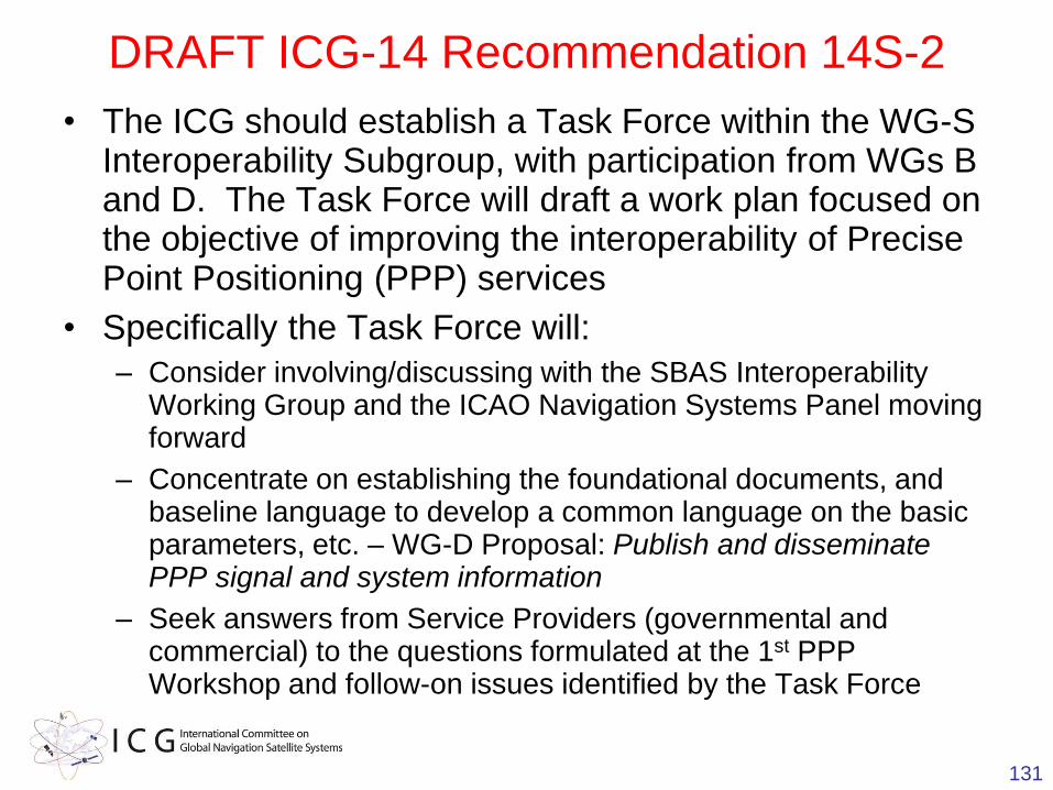
• The ICG should establish a Task Force within the WG-S Interoperability Subgroup, with participation from WGs B and D. The Task Force will draft a work plan focused on the objective of improving the interoperability of Precise Point Positioning (PPP) services
• Specifically the Task Force will:
– Consider involving/discussing with the SBAS Interoperability Working Group and the ICAO Navigation Systems Panel moving forward
– Concentrate on establishing the foundational documents, and baseline language to develop a common language on the basic parameters, etc. – WG-D Proposal: Publish and disseminate PPP signal and system information
– Seek answers from Service Providers (governmental and commercial) to the questions formulated at the 1st PPP Workshop and follow-on issues identified by the Task Force
131

Related Action for WGs S, B, and D
• Nominate Candidates to Co-Chair the Task Force
• Candidates discussed by WG-S include Australia, China, the EU, Japan, and Russia
132

SYSTEM-OF-SYSTEMOPERATIONS

System-of-System Operations
• Investigate methods to ensure orbital de-confliction
among constellations in medium Earth orbit (MEO) and
appropriate application of United Nations Orbital Debris
Mitigation guidelines to this regime implemented through
national practices
• Discuss coordination of constellation configurations
and replenishment of satellites in specific orbital
locations in an effort to improve open service performance
provided by the system of global and regional navigation
satellite systems
• Investigate the overall GNSS open service volume in
order to consider improvement in terms of accuracy,
integrity, availability, reliability and service coverage
134

Disposal Strategy and Collision
Probability of BDS MEO Satellites
Zhou Jing, Yang Hui
Beijing Institute of Spacecraft System Engineering, CAST
UN ICG WG-S Intersessional Meeting
5-7 September 2019,Ispra, Italy

Contents
GNSS Space Debris Status and International Guidelines 1
Proposed Disposal Strategy of BDS MEO Satellites2
Collision Probability Posed to GPS and BDS Constellations 3
1
Summary4
2
GNSS Space Debris Status and International Guidelines

3
Constellation
Nation/AreaNumber of SVs *
GEO IGSO MEO Total
GPS USA 0 0 71 71
GLONASS Russia 0 0 133 133
Galileo Europe 0 0 28 28
BDS China 13 10 26 49
QZSS Japan 1 3 0 4
NAVIC India 3 6 0 9
GNSS/RNSS Satellites in Orbit
Data collected from www.space-track.org by the end of May 2019

4
GNSS Satellites Orbit Altitude
Data collected from www.space-track.org by the end of May 2019
18500
19000
19500
20000
20500
21000
21500
22000
22500
23000
23500
24000
10000 12000 14000 16000 18000 20000 22000 24000 26000 28000 30000 32000 34000 36000 38000 40000 42000 44000
卫星TLE编号
轨道
高度
(km)
GPS-Ha
GPS-Hp
GLONASS-Ha
GLONASS-Hp
Galileo-Ha
Galileo-Hp
BEIDOU-Ha
BEIDOU-Hp
GALILEO(23222km)
BEIDOU(21528km)
GPS(20182km)
GLONASS(19130km)

GNSS Upper-stage Orbit Altitude
5
Data collected from www.space-track.org by the end of May 2019
18500
19000
19500
20000
20500
21000
21500
22000
22500
23000
23500
24000
28000 30000 32000 34000 36000 38000 40000 42000 44000
NORAD_CAT_ID
Orbit Altitude (km)
GPS-UP-Ha
GPS-UP-Hp
GLONASS-UP-Ha
GLONASS-UP-Hp
Galileo-UP-Ha
Galileo-UP-Hp
BEIDOU-UP-Ha
BEIDOU-UP-Hp
GALILEO(23222km)
BEIDOU(21528km)
GPS(20182km)
GLONASS(19130km)

GNSS Spacecraft Disposal Orbit
6
Constellation
De-orbited Satellites De-orbited Upper-stage
Number △Ha (Increase inapogee altitude)
Number △Ha (Increase inapogee altitude)
/km
GPS 36 +350~+1700 12 +600~+1900
GLONASS 0* 0* 21 0~+700
Galileo 2 +120~+600 9 +350~+2900
-300
BDS 4(3GEO/1
MEO)
GEO:+140~+300
MEO:+900
11 +200~+6000
QZSS — — — —
NAVIC — — — —
*Glonass SVs at the end of life didn’t have increase in orbit altitude yet.

GNSS Disposal Orbit Interference
7
Operating
Orbit
Disposal Satellites
Intersected the Operating
Orbit
Disposal Upper-stage
Intersected the Operating
Orbit
NumberDisposal
SatellitesNumber
Disposal Upper-
stage
GPS21200km
0 — 0 —
GLONASS19100km
3 GPS 0 —
Galileo23200km
0 — 0 —
BDS21500km
>30 GPS 10 GPS

8
MEO Disposal Requirements of IADC
Disposal
ActionMEO Navigation Satellite Orbit
25-year
decayNot recommended due to large ΔV required
Disposal orbit
TBC:
1.Minimum long term perigee of 2000km,apogee
below MEO
2.Perigee 500km above MEO or nearby
operational region and e≤0.003;RAAN and
argument of perigee selected for stability
Direct
ReentryNot recommended due to large ΔV required
Requirements from ‘Support to the IADC Space Debris Guidelines’

Proposed Disposal Strategy
of BDS MEO Satellites
9

Disposal Safety Restrictions for BDS MEO satellites
•Based on research of NASA and other organizations, disposal for
post mission MEO satellites should ensure no collision risk with
operational orbit and nearby constellations within 200 years.
To protect nearby constellation and follow-up MEO satellites
operational safety, restrictions for EOL disposal of BDS MEO satellites
are suggested as follows:
10
②Considering propellant limitation and isolation from nearby MEO
satellite orbits, the increase in altitude at the end of re-orbiting
maneuver of MEO satellites should be more than 300km.
③The variation of altitude after disposal should be minimized over
200 years, and the variation of orbit altitude should be less than
200 km within 200 years.

Evolution of BDS MEO Satellites with Different ω0
Ω0=30°,e0=0.001,ω0=0~360
➢Minimum eccentricity growth strategy: ω0 = 190/320/240 deg, the
disposal orbit is very stable (perigee remains above BDS
constellation within 200 years)
➢High eccentricity growth strategy: ω0 = 290/70/350 deg, the
disposal orbit eccentricity grows significantly (perigee crosses the
BDS constellation but does not reach GEO within 200 years)
11
Ω=150°,e=0.001,ω=0~360° Ω=270°,e=0.001,ω=0~360°

Recommendations for BDS MEO Disposal Orbit Elements
RAAN
Increase
in orbit
altitude/k
m
Ecce
ntrici
ty
Minimum Eccentricity
GrowthHigh Eccentricity Growth
ω0 /
deg
Max
Eccentricity
in 200 years
ω0 / deg
Max
Eccentricity
in 200 years
30 300 0.001 190 0.002 290 0.16
150 300 0.001 320 0.006 70 0.14
270 300 0.001 240 0.004 350 0.11
12

Collision Probability Posed to
GPS and BDS Constellations
13

Collision Probability posed to all GPS
and BDS Satellites in Orbit
Collision probability posed to all 25 BDS satellites in orbit by
disposal satellite with minimum eccentricity growth strategy
Collision probability posed to all 25 BDS satellites in orbit by
disposal satellite with high eccentricity growth strategy
14
Collision probability posed to all 63 GPS satellites in orbit by
one disposal satellite with high eccentricity growth strategy
Collision probability posed to all 63 GPS satellites in orbit by one
disposal satellite with minimum eccentricity growth strategy
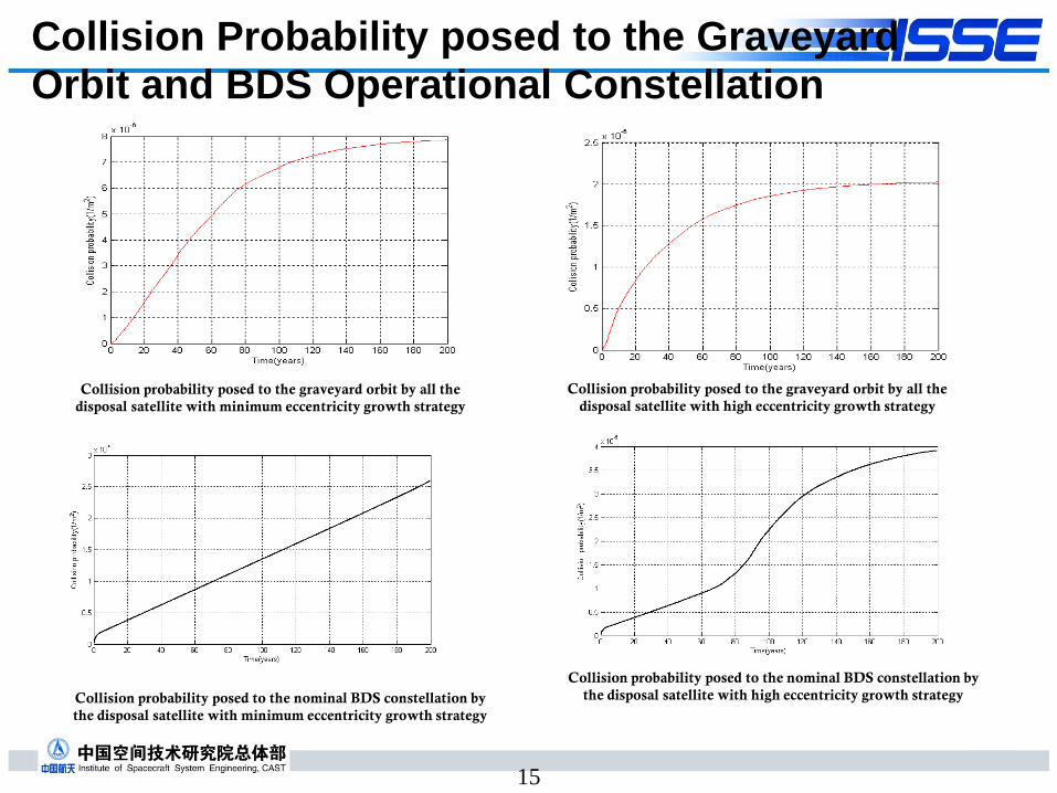
Collision Probability posed to the Graveyard
Orbit and BDS Operational Constellation
Collision probability posed to the graveyard orbit by all the
disposal satellite with minimum eccentricity growth strategy
Collision probability posed to the graveyard orbit by all the
disposal satellite with high eccentricity growth strategy
15
Collision probability posed to the nominal BDS constellation by
the disposal satellite with minimum eccentricity growth strategy
Collision probability posed to the nominal BDS constellation by
the disposal satellite with high eccentricity growth strategy

Comparison of the Collision Probability
➢The collision probability posed to operational orbit or graveyard orbit is of a 10-5 ~10-6
order of magnitude, which is less than the 0.001 threshold for LEO-crossing objects.
➢The high eccentricity growth strategy results in a lower collision probability to the BDS graveyard orbit than the minimum eccentricity growth strategy.
➢The minimum eccentricity growth strategy results in a lower collision probability to the BDS nominal constellation than the high eccentricity growth strategy.
➢As for BDS MEO EOL satellites, the minimum eccentricity growth strategy would be proposed.
Cumulative Collision Probability after 200 years
Minimum eccentricity
growth strategy
High eccentricity
growth strategy
Posed to all 69 GPS satellites in orbit by one BDS disposal Satellite
1.02×10⁻⁶ 1.08×10⁻⁶
Posed to all 25 BDS satellites in orbit
by one disposal satellite 1.1×10⁻⁶ 1.25×10⁻⁶
Posed to graveyard orbit by one BDS
disposal satellite 7.9×10⁻⁶ 2.0×10⁻⁶
Posed to nominal constellation by 24
BDS disposal satellites 2.6×10⁻⁵ 3.9×10⁻⁵
16

17
Summary

Summary
①There are no final guidelines for GNSS MEO satellites
post-mission disposal from international organizations
(IADC), while post-mission disposal strategy and safety
restrictions of GNSS EOL satellites are not exactly the same.
②As there will be more GNSS satellites deployed in the
future, there will be more intersections among the GNSS
constellations as well. As a result, further investigations of
the collision probability after disposal of GNSS MEO
satellites with own constellation and nearby constellations should be carried out by all system providers.
18

19
•ICG members should pay more attention to the safety of MEO and IGSO space debris:
➢System providers should continue to exchange
information on their GNSS/RNSS satellites post-mission disposal plans and implements in WG-S.
③System providers should try to establish the GNSS/RNSS space debris guidelines together with IADC.
Summary

ICG-13 Recommendation 13S-2 (1)IADC MEO/IGSO Study
Background/Brief Description of the Issue:
There are guidelines for post-mission disposal for GEO and LEO
region, however, there are no specific guidelines for GNSS/RNSS
MEO and IGSO satellites post-mission disposal from international
organizations.
Discussion/Analyses:
In the past few meetings of WG-S, reports on GNSS satellites
disposal orbit for space debris mitigation were presented.
Observation shows some GNSS retired spacecrafts are very likely
close to other GNSS operational orbits. For system orbit safety,
information on orbital debris mitigation plans need to be
exchanged on a regular basis, and it requires the service
providers to develop guidelines for GNSS MEO and IGSO satellite
disposal together.
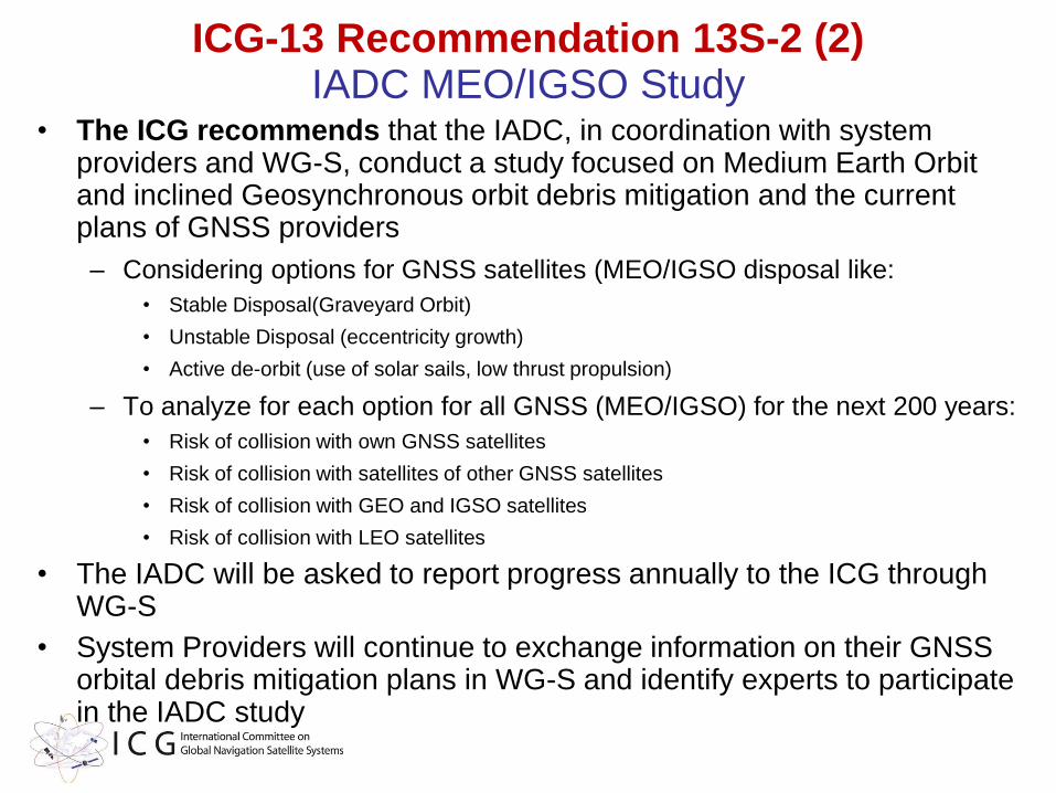
ICG-13 Recommendation 13S-2 (2)IADC MEO/IGSO Study
• The ICG recommends that the IADC, in coordination with system providers and WG-S, conduct a study focused on Medium Earth Orbit and inclined Geosynchronous orbit debris mitigation and the current plans of GNSS providers
– Considering options for GNSS satellites (MEO/IGSO disposal like:
• Stable Disposal(Graveyard Orbit)
• Unstable Disposal (eccentricity growth)
• Active de-orbit (use of solar sails, low thrust propulsion)
– To analyze for each option for all GNSS (MEO/IGSO) for the next 200 years:
• Risk of collision with own GNSS satellites
• Risk of collision with satellites of other GNSS satellites
• Risk of collision with GEO and IGSO satellites
• Risk of collision with LEO satellites
• The IADC will be asked to report progress annually to the ICG through WG-S
• System Providers will continue to exchange information on their GNSS orbital debris mitigation plans in WG-S and identify experts to participate in the IADC study
NEXT STEPS

• Compatibility & Spectrum Subgroup Events
• Interoperability & Service Standards Events
• PPP Workshop with WG’s B & D – to be determined
• WG-S Intersessional Meeting
• Related meetings to be aware of:
– iGNSS 2020, February 5-7
– Munich Satellite Navigation Summit, March 16-18
– Moscow GNSS Forum, April 21-22
– ITU WP-4C, May 13-19
– Baska GNSS Conference, May 17-21
– CSNC 2020, May [20-22]
– ICG 15, September 14-18
Proposed Post-ICG-14 Working Group Schedule

Previous Recommendations and Status – to be updated

Previous ICG WG-A recommendations implementation summary - 2009 (ICG-4)
No/Year Brief description Status
1 / 2009 Revised Work Plan for WG-A Closed
2 / 2009 Continue seeking inputs on interoperability
from industry and users - Conduct a workshop
at iGNSS 2009
Closed – new
effort initiated @
ICG-5
3 / 2009 Conduct a compatibility-focused meeting prior
to ICG-5 – scheduled for June 2010 in Vienna
Closed – led to
formation of sub-
group
4 / 2009 Endorse the multi-GNSS demonstration
campaign and encourage Provider
participation
Closed – Some
providers actively
participate
5 / 2009 Principle of Transparency - every GNSS provider
should publish documentation that describes the
signal and system information, the policies of
provision and the minimum levels of performance
offered for its open services
Closed – Principle
adopted by
Providers
Previous ICG WG-A recommendations implementation summary - 2010 (ICG-5)
No/Year Brief description Status
2.1 /2010 Continue the Work of the Sub-group
Compatibility (Organizational Models and
Procedures for Multilateral Discussions)
Specific focus
abandoned – sub-
group continues
2.2 /2010 Common Reference Assumptions for
Compatiblity Coordination
Specific focus
abandoned by
sub-group
3.1. /2010 IDM Study Plan and ICG Participation Closed – evolved
to IDM task force
5.1 / 2010 New approach to continued collection of user
and industry views on interoperability
Open - Task
Force evaluating
workshop results
5.2 /2010 Continue to investigate system time and geodetic
reference frame aspects of interoperability within
the WG-D task forces on time and geodesy
Ongoing –
templates
completed by WG-D
5.3 / 2010 ICG participant participation in Asia-Oceania Multi-
GNSS Demonstration Campaign and
interaction with receiver manufacturers
Closed –
effectiveness should
be evaluated

Previous ICG WG-A recommendations implementation summary
2011 (ICG-6)
No/Year Brief description Status
2.1 /2011 Continuation of WG-A compatibility subgroup Closed. SG is
Active
3.1 /2011 Workshop on GNSS Spectrum Protection and
IDM
Closed. Became
1st IDM workshop
4.1 /2011 Open Service GNSS performance
parameters, including Definitions and
Calculation Methods
Open
4.2 / 2011 International GNSS Monitoring and
Assessment Sub-Group
Implemented -
Became Task Force
with WG-A and D
Still Active

Previous ICG WG-A recommendations implementation summary
2012 (ICG-7)
No/Year Brief description Status
2.1
2012
RNSS spectrum protection from ITM. Joint
efforts in ITU
Closed
8A.2.1 issued
3.2
2012
Conduct IDM workshops Implemented - 4
workshops to date
4.1
2012
Extend tasks of IGMA Task Force to include
the parameters definition elaboration
Implemented –
work is
incomplete
5.1
2012
Interoperability workshops based on the
Questionnaire
Implemented – 5
of 6 Providers
held workshops
Previous ICG WG-A recommendations implementation summary
2013 (ICG-8)
No/Year Brief description Status
8A.2.1
2013
ICG Members to joint efforts in ITU for GNSS
spectrum protection from ITM
Closed
9A.2.1. issued
8A.2.2.
2013
Update brochure on GNSS with existing or
expected performance for open service
Open
8A.3.1.
2013
Educational materials on GNSS features and
why they are differ from communication
Open
8A.3.2.
2013
Establish an IDM Task Force Implemented -
Task Force still
active
8A4.1 Rearrange the WG-A(B,D) IGMA Task Force
to ICG IGMA Task Force
Open
8A5.1
2013
Establish an Interoperability Task Force to
process data from workshops
Implemented -
Task Force still
active

Previous ICG WG-A recommendations implementation summary
2014 (ICG-9)
No/Year Brief description Status
9A.2.1.
2014
ICG Members to join efforts in ITU-R and
WRC-2015 for GNSS spectrum protection
from ITM
Closed – revised
as new
recommendation
for ICG-11
9A.3.1
2014
Evaluate existing and emerging IDM
capabilities and consider developing, testing
and implementing these or similar capabilities
Open
9A.3.2.
2014
Crowdsourcing capabilities analysis for IDM Open
9A.3.3. UN regional workshops on GNSS spectrum
protection and IDM
Open. Moved to
Comp. Subgroup
9A.4.1.
2014
National service monitoring center websites to
connect to ICG internet portal
Updated as 10A/S.3
and Closed
9A.4.2.
2014
IGMA Workshop in Xi’an in May, 2015 Completed,
Closed

Previous ICG WG-A recommendations implementation summary 2015 (ICG-10)
No/Year Brief description Status
10A/S.1
2015
Campaign of Protection of RNSS operations
–
GNSS providers and GNSS user community
member states promote spectrum protection
Open –Implementation
through spectrum
protection seminars
10A/S.2
2015
UN COPUOS multi-year agenda item
focused on National Efforts to protect RNSS
Spectrum, and develop IDM capability
Open
10A/S.3
2015
Existing GNSS open service information
linked to the ICG portal
Open
10A/S.4
2015
IGMA TF and IGS joint trial project to
demonstrate a global GNSS Monitoring and
Assessment capability
Open – project
initiated
10A/S.5
2015
Updated work plan focused on GNSS civil
service provision by a system-of-systems
and WG name change
Completed,
Closed
GNSS Jammers – National Legal Status(As Reported at ICG-9)
Jammers US RU China EU
manufacture illegal illegal illegal Nation-by-
nation
sell illegal illegal illegal illegal
export illegal illegal illegal Nation-by-
nation
purchase Undefined(consumer
import illegal)
illegal illegal illegal
own legal Undefined Undefined legal
use illegal illegal illegal illegal

GNSS as Critical Infrastructure(as reported at ICG-9)
US RU China EU
There is official
Critical
Infrastructure
definition
There is no official
Critical
Infrastructure
definition
There is no official
Critical
Infrastructure
definition
There is official
Critical
Infrastructure
definition
GPS is not a
critical
infrastructure
Navigation is a
critical technology
BeiDou is
Essential Space
Infrastructure
Galileo will be
designated as
critical
infrastructure
GPS integrated in
most of all critical
infrastructures
GLONASS is
integrated in most
of all priority
development
directions of
science and
technique
Beidou is
integrated in most
of all economy
branches
Galileo service is
critical to Energy
and Transport
critical
infrastructure
sectors

Former WG-A Architecture
WG-A
Spectrum Protection (User
Level) & IDM
GNSS Open Service Monitoring and Assessment
InteroperabilityGNSS Updates
Compatibility, Spectrum
Protection (System Level) and Open
Service Information Sharing
(Performance Standard)
Compatibility & Performance
Standard Sub-group
Interference Detection
Task Force
IGMA Task Force
Interoperability Task Force
WG-B WG-D
54321

ICG Spectrum Stewardship Life-Cycle
Standard Setting Entities(including ITU)
Spectrum Management
Education
Crowd Sourcing IDM
Network IDM
Reporting and Actions
UN COPUOSSTSC
INPUTS
▪ Government
▪ Academia
▪ Industry
▪ User Community
▪ ITU
COPUOSMember States
Pro
posa
ls f
or
Tools
& T
ech
niq
uesVoluntary National Reports
ICGWG-S
C&SPSubgr
IDM Task Force
IDM WorkSh
Data Collection and Analysis
National
Reports
Proposals for UN
Requests to study