iceland 2010 guide - part a - cuesta consulting
TRANSCRIPT
Iceland 2010A retrospective guide to the locations and features visited on the
31st Anniversary Liverpool ‘ICEX’ Tour
Section 2
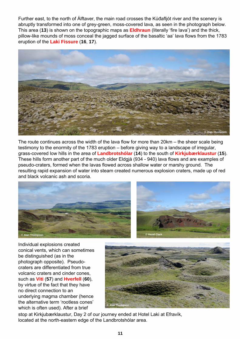
Further east, to the north of Álftaver, the main road crosses the Kúđafljót river and the scenery is abruptly transformed into one of grey-green, moss-covered lava, as seen in the photograph below. This area (13) is shown on the topographic maps as Eldhraun (literally ‘fire lava’) and the thick, pillow-like mounds of moss conceal the jagged surface of the basaltic ‘aa’ lava flows from the 1783 eruption of the Laki Fissure (16, 17).
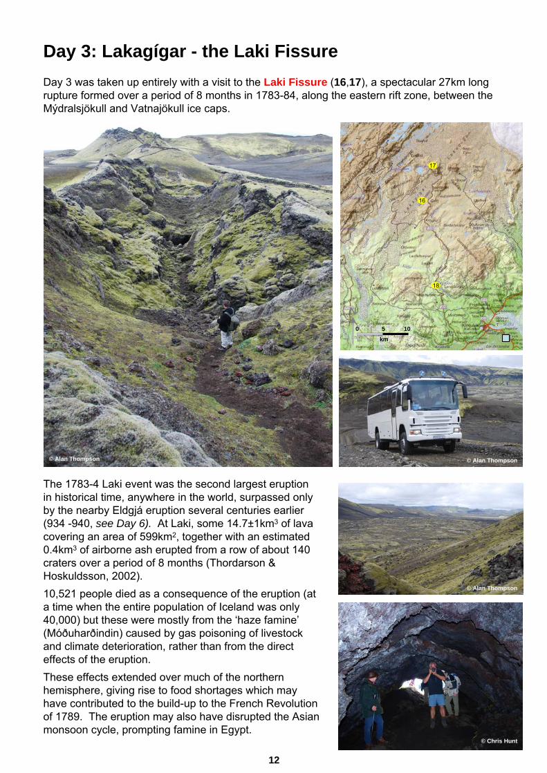
The route continues across the width of the lava flow for more than 20km – the sheer scale being testimony to the enormity of the 1783 eruption – before giving way to a landscape of irregular, grass-covered low hills in the area of Landbrotshólar (14) to the south of Kirkjubærklaustur (15). These hills form another part of the much older Eldgjá (934 - 940) lava flows and are examples of pseudo-craters, formed when the lavas flowed across shallow water or marshy ground. The resulting rapid expansion of water into steam created numerous explosion craters, made up of red and black volcanic ash and scoria.
Individual explosions created conical vents, which can sometimes be distinguished (as in the photograph opposite). Pseudo-craters are differentiated from true volcanic craters and cinder cones, such as Viti (57) and Hverfell (60), by virtue of the fact that they have no direct connection to an underlying magma chamber (hence the alternative term ‘rootless cones’which is often used). After a brief
© Hazel Clark
stop at Kirkjubærklaustur, Day 2 of our journey ended at Hotel Laki at Efravík, located at the north-eastern edge of the Landbrotshólar area.
11
© Alan Thompson
© Alan Thompson
© Alan Thompson
Day 3: Lakagígar - the Laki Fissure
18
16
17
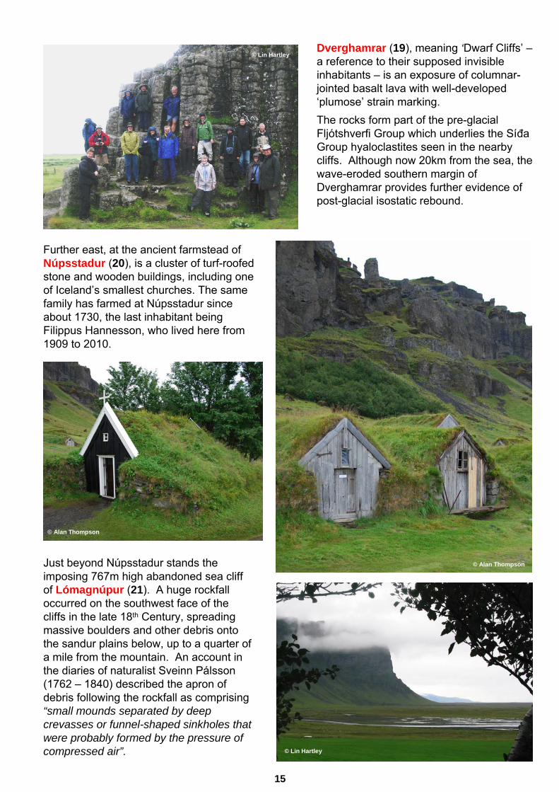
Day 3 was taken up entirely with a visit to the Laki Fissure (16,17), a spectacular 27km long rupture formed over a period of 8 months in 1783-84, along the eastern rift zone, between the Mýdralsjökull and Vatnajökull ice caps.
The 1783-4 Laki event was the second largest eruption in historical time, anywhere in the world, surpassed only by the nearby Eldgjá eruption several centuries earlier (934 -940, see Day 6). At Laki, some 14.7±1km3 of lava covering an area of 599km2, together with an estimated 0.4km3 of airborne ash erupted from a row of about 140 craters over a period of 8 months (Thordarson & Hoskuldsson, 2002). 10,521 people died as a consequence of the eruption (at a time when the entire population of Iceland was only 40,000) but these were mostly from the ‘haze famine’(Móðuharðindin) caused by gas poisoning of livestock and climate deterioration, rather than from the direct effects of the eruption. These effects extended over much of the northern hemisphere, giving rise to food shortages which may have contributed to the build-up to the French Revolution of 1789. The eruption may also have disrupted the Asian monsoon cycle, prompting famine in Egypt.
© Chris Hunt
12
0 5 10
km
© Alan Thompson © Alan Thompson
© Alan Thompson
N

The photographs here and on the previous page show some of the most accessible features at the northern end of the fissure, including volcanic vents and lava flows.
Fagrifoss (18), meaning ‘beautiful falls’, spills over a succession of much older subglacial extrusive rocks and intercalated sediments, which form the highlands to the south of Laki. These rocks are intruded by numerous sub-vertical dykes, some of which, due to differential weathering, form prominent features immediately downstream of the waterfall.
© Ronald Leong
© John Iley
© Bob & Margaret
13
© Alan Thompson
© Alan Thompson
© Alan Thompson

Day 4: Kirkjubærklaustur to SvínafellThe small town of Kirkjubærklaustur lies within a green oasis of fertile land between the vast lava fields and barren outwash plains on either side. For centuries it has been a vital staging post along the southern coastal route, and is still the last opportunity to obtain fuel and provisions before setting off across the Skeidarársandur (travelling eastwards) or the equally formidable Mýrdalssandur (if travelling west). The name is literally translated as ‘Church Farm Cloister’. According to the Sagas this was one of the places where pilgrim Irish monks made their homesome years before the first Viking settlers arrived.
The most spectacular event in the history of the town occurred during the infamous Laki Fissure eruption. The advancing lava flow had reached the outskirts of the town on Sunday 20th July 1783. The pastor, Jón Steingrímsson summoned his terrified flock to the little church that stood inthe path of the advancing lava. He ordered the doors to be closed and then proceeded to deliver a passionate oratory, now remembered as the Eldmessa – ‘fire sermon’. When the congregation stumbled out of the church at noon into the choking, smoking darkness the lava had stopped!
From Kirkjubærklaustur, our route headed initially north-east, along the fertile coastal plain flanked to the north by an almost continuous line of ancient sea cliffs, punctuated by a series of ravines and waterfalls.
The cliffs here form part of the same (Upper Pliocene to Pleistocene) sequence of rocks (the Síđa Group) seen at Fagrifoss (see Day 3) and are dominated by subaqueous hyaloclastite lava flows, emplaced onto a submarine shelf (Thordarson & Hoskuldsson, 2002). As at Seljalandsfoss (see Day 2), the cliffs were eroded during the Quaternary glaciations but have since been abandoned by the sea due to the isostatic uplift of the land as the ice sheets have waned.
© Hazel Clark
14
23
24
26 27
28
37
3036
35
31
32
3334
21
22
25
29
20 21
19
0 5 10
km
N
Dverghamrar (19), meaning ‘Dwarf Cliffs’ –a reference to their supposed invisible inhabitants – is an exposure of columnar-jointed basalt lava with well-developed ‘plumose’ strain marking. The rocks form part of the pre-glacial Fljótshverfi Group which underlies the Síđa Group hyaloclastites seen in the nearby cliffs. Although now 20km from the sea, the wave-eroded southern margin of Dverghamrar provides further evidence of post-glacial isostatic rebound.
Just beyond Núpsstadur stands the imposing 767m high abandoned sea cliff of Lómagnúpur (21). A huge rockfall occurred on the southwest face of the cliffs in the late 18th Century, spreading massive boulders and other debris onto the sandur plains below, up to a quarter of a mile from the mountain. An account in the diaries of naturalist Sveinn Pálsson(1762 – 1840) described the apron of debris following the rockfall as comprising “small mounds separated by deep crevasses or funnel-shaped sinkholes that were probably formed by the pressure of compressed air”.
Further east, at the ancient farmstead of Núpsstadur (20), is a cluster of turf-roofed stone and wooden buildings, including one of Iceland’s smallest churches. The same family has farmed at Núpsstadur since about 1730, the last inhabitant being Filippus Hannesson, who lived here from 1909 to 2010.
© Lin Hartley
© Lin Hartley
15
© Alan Thompson
© Alan Thompson