i. purpose and authority
TRANSCRIPT
Page 1 of 63 EA No.
INITIAL STUDY/MITIGATED NEGATIVE DECLARATION FOR 92,000 S.F. CANNABIS CULTIVATION AND MANUFACTURING FACILITY,
LOCATED WESTERLY OF MITCHELL BOULEVARD AND SOUTHERLY OF LINDERBERGH BOULEVARD ON 5-ACRES
(APNs: 216-010-30 & 216-010-14)
I. Purpose and Authority
Project Description:
This Initial Study has been prepared to construct a commercial cannabis cultivation and manufacturing
facility in accordance with adopted City Ordinances pertaining to the location and regulation of
cannabis cultivation and manufacturing facility. The City of California City zones the subject property as
Light Industrial (M-1), which authorizes a commercial cannabis cultivation and manufacturing facility,
pursuant to the codified California City Municipal Code as Title 9, Chapter 2, Articles 21 and 29, and
Title 5, Chapter 6, of the same. The Project is only subject to a site plan review and building permit, as
applicable; however, the use requires the preparation of an Initial Study to review, analyze and evaluate the
possible effects resulting upon the surrounding environment. The types of uses, authorized in the M-1
zone include commercial cannabis cultivation, distribution, manufacturing, testing, and ancillary uses
necessary thereto. These facilities are subject to all State Law and regulations including the
California Code of Regulations, Title 21, Division 42, Bureau of Cannabis Control.
The City of California City allows commercial cannabis cultivation, manufacturing, distribution, and testing
facilities, as a permitted use on property zoned M-1 – Light Industrial. Commercial cannabis cultivation
and manufacturing shall be permitted, in accordance with the criteria and procedures set forth Title 5,
Chapter 6 of the California City Municipal Code and upon application and approval of a regulatory permit
pertaining to operation of the facility including the duty to obtain any, and all, required state licenses.
The proposed project is located in M-1 – Light Industrial. All cannabis related activities are only
permitted in the interior of enclosed structures, facilities, and buildings.
The proposed project (“Project”) encompasses approximately 5-acres of vacant land located within the City of California City. More specifically, the property is located adjacent to, and easterly of Mitchell Blvd. and southerly of Willow Ave., which is generally considered the central-westerly portion of California City, about 1.3-miles, northerly of California City Blvd. The Project is generally surrounded by industrial and manufacturing development (M-1) to the north, south, and west. East is R-1. The Project is identified by Assessor’s Parcel Numbers (APNs): 216-010-30 & 216-010-14. The Project site is zoned Light Industrial Zoning District (M-1) and carries a General Plan Land Use Designation consistent with General Plan Land policy 1.2. The Project proposes approximately 92,000 square feet (sf) of commercial cannabis cultivation that is contained within a maximum of ten (10) pre-fabricated metal industrial buildings, eight (8) of which consists of approximately 10,000 SF each, and two (2) buildings consisting of approximately 6,000 SF. The Project also incorporates one (1), 500 SF office and guard structure. The Project site plan also incorporates one (1) retention basin that encompass approximately 3,800 sf (approximately 2%) of the Project site. The Project will be developed in one phase, which will include the frontage improvements and the construction of a commercial driveway approach along Mitchell Blvd. The Project proponent shall also provide all-weather site access for emergency/fire/police access within an internal driveway that provides circulation around the entire site plan. The Project also incorporates 18 parking spaces (including those available for persons with disabilities), storage facilities, and associated ancillary cannabis manufacturing facilities.
Page 2 of 63 EA No.
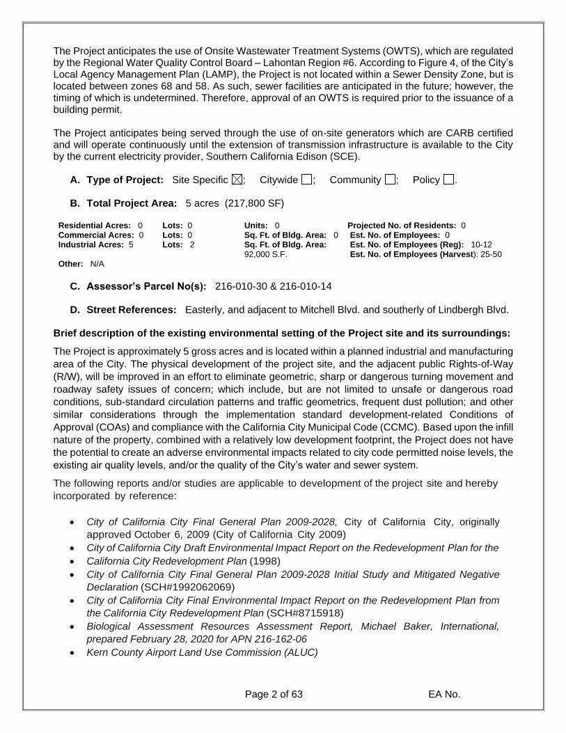
The Project anticipates the use of Onsite Wastewater Treatment Systems (OWTS), which are regulated by the Regional Water Quality Control Board – Lahontan Region #6. According to Figure 4, of the City’s Local Agency Management Plan (LAMP), the Project is not located within a Sewer Density Zone, but is located between zones 68 and 58. As such, sewer facilities are anticipated in the future; however, the timing of which is undetermined. Therefore, approval of an OWTS is required prior to the issuance of a building permit. The Project anticipates being served through the use of on-site generators which are CARB certified and will operate continuously until the extension of transmission infrastructure is available to the City by the current electricity provider, Southern California Edison (SCE).
A. Type of Project: Site Specific ; Citywide ; Community ; Policy .
B. Total Project Area: 5 acres ) 217,800 SF(
Residential Acres: 0 Lots: 0 Units: 0 Projected No. of Residents: 0 Commercial Acres: 0 Lots: 0 Sq. Ft. of Bldg. Area: 0 Est. No. of Employees: 0 Industrial Acres: 5 Lots: 2 Sq. Ft. of Bldg. Area:
92,000 S.F. Est. No. of Employees (Reg): 10-12 Est. No. of Employees (Harvest): 25-50
Other: N/A
C. Assessor’s Parcel No(s): 216-010-30 & 216-010-14
D. Street References: Easterly, and adjacent to Mitchell Blvd. and southerly of Lindbergh Blvd.
Brief description of the existing environmental setting of the Project site and its surroundings:
The Project is approximately 5 gross acres and is located within a planned industrial and manufacturing
area of the City. The physical development of the project site, and the adjacent public Rights-of-Way
(R/W), will be improved in an effort to eliminate geometric, sharp or dangerous turning movement and
roadway safety issues of concern; which include, but are not limited to unsafe or dangerous road
conditions, sub-standard circulation patterns and traffic geometrics, frequent dust pollution; and other
similar considerations through the implementation standard development-related Conditions of
Approval (COAs) and compliance with the California City Municipal Code (CCMC). Based upon the infill
nature of the property, combined with a relatively low development footprint, the Project does not have
the potential to create an adverse environmental impacts related to city code permitted noise levels, the
existing air quality levels, and/or the quality of the City’s water and sewer system.
The following reports and/or studies are applicable to development of the project site and hereby
incorporated by reference:
• City of California City Final General Plan 2009-2028, City of California City, originally
approved October 6, 2009 (City of California City 2009)
• City of California City Draft Environmental Impact Report on the Redevelopment Plan for the
• California City Redevelopment Plan (1998)
• City of California City Final General Plan 2009-2028 Initial Study and Mitigated Negative
Declaration (SCH#1992062069)
• City of California City Final Environmental Impact Report on the Redevelopment Plan from
the California City Redevelopment Plan (SCH#8715918)
• Biological Assessment Resources Assessment Report, Michael Baker, International,
prepared February 28, 2020 for APN 216-162-06
• Kern County Airport Land Use Commission (ALUC)

Page 3 of 63 EA No.
This document has been prepared in accordance with the California Environmental Quality Act
(CEQA), Public Resources Code Section 250 et. seq. The City of California City will serve as the
lead agency pursuant to CEQA.
II. APPLICABLE GENERAL PLAN AND ZONING REGULATIONS
A. General Plan Elements/Policies:
1. Land Use: M-1 (Light Industrial Zoning District)
2. Circulation: Mitchell Blvd. will provide the primary point of ingress and egress as Mitchell Blvd. is the adjacent roadway to provide publicly dedicated serves Project. In order to facilitate circulation, throughout the project site, and accommodate secondary access, required per the City’s codified fire code, the City will require the dedication and improvement of a commercial driveway approach which will extend from Mitchell Blvd. from the east. This driveway will be a 26-foot private access easement that traverses from east to the west from Mitchell Blvd.
3. Multipurpose Open Space: The Project is located within a planned industrial area of
California City. The project will not create a need for additional open space and/or active
park recreational facilities. Furthermore, the Project does not preclude or remove any active
parkland and/or passive open space, trails, bike paths, or other similar facilities. The project
is located adjacent to a designated conversation area and will need to address possible
interface guidelines set forth by the California Department of Fish & Wildlife (CDFW) and the
USFWS.
4. Safety: The Project is not located upon, or within, an area of hazardous materials as
detailed within the applicable state and federal resource maps. The Project is located within
the Sphere of Influence (SOI) or Airport Influence Area (AIA) of the California City Municipal
Airport Comprehensive Land Use Plan (CLUP). As such, the Project will not impact airport
operations in any manner. The Project will not create any dangerous or hazardous circulation
geometrics which would cause a concern for the motoring public.
5. Noise: The Project is located within a planned industrial area of the City where the majority
of ambient noise generation is caused by the Average Daily Trips (ADT) associated with
vehicle traffic trips occurring along Mitchell Blvd. The Project may create an increase in the
levels of ambient noise given the adjacency to an existing area of land conservation and will
need to address possible interface guidelines set forth by the California Department of Fish
& Wildlife (CDFW) and the USFWS.
6. Housing: The Project is located on vacant land, within the M-1 (Light Industrial Zoning
District) and does not propose to remove or displace any housing, of any type on, or adjacent
to the Project boundaries, as no dwelling units exist either on the project site. The Project
site is surrounded by vacant land in all directions, with planned industrial areas (M-1 zoning
district) located to the north, west, and south and One-Family Dwellings (R-1) to the east.
The Project is subject to City ordinance which requires all cultivation buildings shall be
located at-least 200-feet from this existing residential property, as residential (R-1) zoning
currently exists or is anticipated to be changed prior to the Project approval. The Project will
comply with the City’s distance requirements.
Page 4 of 63 EA No.
7. Air Quality: The Project will not substantially increase the baseline air quality emissions
resulting from either the construction or operations of the cannabis cultivation and
manufacturing facility. The Project is not anticipated to produce pollutants of concern in
excess of SCAQMD thresholds for elements such as NOx; SOx; or O3. The Project will require
the use of generators (powered by either gas or diesel fuel) during construction and/or initial
operations. Generators shall be certified by the California Air Resources Board (CARB) and
obtain a permit from the East Kern Air Pollution Control District (EKAPCD), as applicable.
Southern California Edison (SCE) will provide the project site with both temporary and
permanent power service.
8. Healthy Communities: The Project does not contribute and will not impede or impact
aspects of the City’s Healthy Community strategies. The City’s Health Communities goals
include, but are not limited to, decreasing the total Vehicle Miles Traveled (VMT); which in
turn reduces emissions (having a positive benefit upon public health); increases in transit
ridership; and expansion of healthy grocery items, including Certified Farmer’s Markets and
other similar opportunities.
B. General Plan Area Plan(s): M-1 (Light Industrial Zoning District)
C. Land Use Designation(s): Land Use Policy 1.2
D. Overlay(s), if any: N/A
E. Policy Area(s), if any: N/A
F. Adjacent and Surrounding:
1. Land Use Designation(s): Land Use Policy 1.2
2. Overlay(s), if any: N/A
3. Policy Area(s), if any: N/A
G. Adopted Specific Plan Information
1. Name and Number of Specific Plan, if any: N/A
2. Specific Plan Planning Area, and Policies, if any: N/A
H. Existing Zoning: M-1 (Light Industrial Zoning District)
I. Proposed Zoning, if any: N/A
J. Adjacent and Surrounding Zoning: M-1 (Light Industrial Zoning District) located to the north,
west, and south, and One-Family Dwellings (R-1) located to the east.
III. ENVIRONMENTAL FACTORS POTENTIALLY AFFECTED
The environmental factors checked below (x) would be potentially affected by this Project, involving at
least one impact that is a “Potentially Significant Impact” or “Less than Significant with Mitigation
Incorporated” as indicated by the checklist on the following pages.
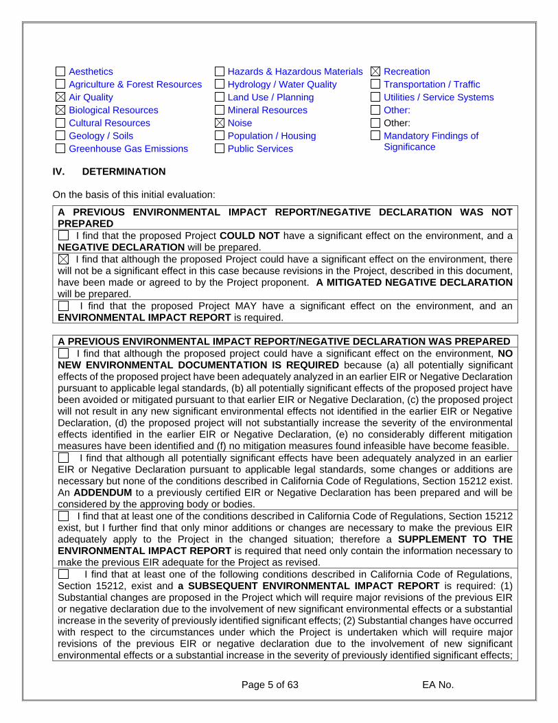
Page 5 of 63 EA No.
Aesthetics Hazards & Hazardous Materials Recreation
Agriculture & Forest Resources Hydrology / Water Quality Transportation / Traffic
Air Quality Land Use / Planning Utilities / Service Systems
Biological Resources Mineral Resources Other:
Cultural Resources Noise Other:
Geology / Soils Population / Housing Mandatory Findings of Significance Greenhouse Gas Emissions Public Services
IV. DETERMINATION On the basis of this initial evaluation:
A PREVIOUS ENVIRONMENTAL IMPACT REPORT/NEGATIVE DECLARATION WAS NOT PREPARED
I find that the proposed Project COULD NOT have a significant effect on the environment, and a NEGATIVE DECLARATION will be prepared.
I find that although the proposed Project could have a significant effect on the environment, there will not be a significant effect in this case because revisions in the Project, described in this document, have been made or agreed to by the Project proponent. A MITIGATED NEGATIVE DECLARATION will be prepared.
I find that the proposed Project MAY have a significant effect on the environment, and an ENVIRONMENTAL IMPACT REPORT is required.
A PREVIOUS ENVIRONMENTAL IMPACT REPORT/NEGATIVE DECLARATION WAS PREPARED
I find that although the proposed project could have a significant effect on the environment, NO NEW ENVIRONMENTAL DOCUMENTATION IS REQUIRED because (a) all potentially significant effects of the proposed project have been adequately analyzed in an earlier EIR or Negative Declaration pursuant to applicable legal standards, (b) all potentially significant effects of the proposed project have been avoided or mitigated pursuant to that earlier EIR or Negative Declaration, (c) the proposed project will not result in any new significant environmental effects not identified in the earlier EIR or Negative Declaration, (d) the proposed project will not substantially increase the severity of the environmental effects identified in the earlier EIR or Negative Declaration, (e) no considerably different mitigation measures have been identified and (f) no mitigation measures found infeasible have become feasible.
I find that although all potentially significant effects have been adequately analyzed in an earlier EIR or Negative Declaration pursuant to applicable legal standards, some changes or additions are necessary but none of the conditions described in California Code of Regulations, Section 15212 exist. An ADDENDUM to a previously certified EIR or Negative Declaration has been prepared and will be considered by the approving body or bodies.
I find that at least one of the conditions described in California Code of Regulations, Section 15212 exist, but I further find that only minor additions or changes are necessary to make the previous EIR adequately apply to the Project in the changed situation; therefore a SUPPLEMENT TO THE ENVIRONMENTAL IMPACT REPORT is required that need only contain the information necessary to make the previous EIR adequate for the Project as revised.
I find that at least one of the following conditions described in California Code of Regulations, Section 15212, exist and a SUBSEQUENT ENVIRONMENTAL IMPACT REPORT is required: (1) Substantial changes are proposed in the Project which will require major revisions of the previous EIR or negative declaration due to the involvement of new significant environmental effects or a substantial increase in the severity of previously identified significant effects; (2) Substantial changes have occurred with respect to the circumstances under which the Project is undertaken which will require major revisions of the previous EIR or negative declaration due to the involvement of new significant environmental effects or a substantial increase in the severity of previously identified significant effects;

Page 6 of 63 EA No.
or (3) New information of substantial importance, which was not known and could not have been known with the exercise of reasonable diligence at the time the previous EIR was certified as complete or the negative declaration was adopted, shows any the following:(A) The Project will have one or more significant effects not discussed in the previous EIR or negative declaration;(B) Significant effects previously examined will be substantially more severe than shown in the previous EIR or negative declaration;(C) Mitigation measures or alternatives previously found not to be feasible would in fact be feasible, and would substantially reduce one or more significant effects of the Project, but the Project proponents decline to adopt the mitigation measures or alternatives; or,(D) Mitigation measures or alternatives which are considerably different from those analyzed in the previous EIR or negative declaration would substantially reduce one or more significant effects of the Project on the environment, but the Project proponents decline to adopt the mitigation measures or alternatives.
April 15, 2021
Signature Date
Shawn Monk For Shawn Monk, City Planner
Printed Name
Figure 1-1: Regional Vicinity Map

Page 7 of 63 EA No.
Figure 1-2: Project Location Map
Page 8 of 63 EA No.
V. ENVIRONMENTAL ISSUES ASSESSMENT In accordance with the California Environmental Quality Act (CEQA) (Public Resources Code Section
250-21178.1), this Initial Study has been prepared to analyze the proposed Project to determine any
potential significant impacts upon the environment that would result from construction and
implementation of the Project. In accordance with California Code of Regulations, Section 15063, this
Initial Study is a preliminary analysis prepared by the Lead Agency, City of California, in consultation
with other jurisdictional agencies, to determine whether a Negative Declaration, Mitigated Negative
Declaration, or an Environmental Impact Report is required for the proposed Project. The purpose of
this Initial Study is to inform the decision-makers, affected agencies, and the public of potential
environmental impacts associated with the implementation of the proposed Project.
Potentially Significant
Impact
Less than Significant
with Mitigation
Incorporated
Less Than
Significant Impact
No Impact
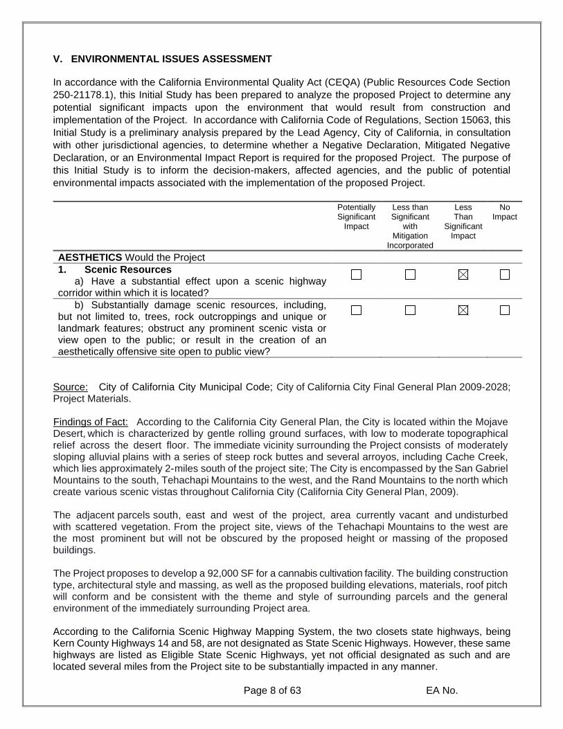
AESTHETICS Would the Project
1. Scenic Resources a) Have a substantial effect upon a scenic highway
corridor within which it is located?
b) Substantially damage scenic resources, including, but not limited to, trees, rock outcroppings and unique or landmark features; obstruct any prominent scenic vista or view open to the public; or result in the creation of an aesthetically offensive site open to public view?
Source: City of California City Municipal Code; City of California City Final General Plan 2009-2028; Project Materials. Findings of Fact: According to the California City General Plan, the City is located within the Mojave Desert, which is characterized by gentle rolling ground surfaces, with low to moderate topographical relief across the desert floor. The immediate vicinity surrounding the Project consists of moderately sloping alluvial plains with a series of steep rock buttes and several arroyos, including Cache Creek, which lies approximately 2-miles south of the project site; The City is encompassed by the San Gabriel Mountains to the south, Tehachapi Mountains to the west, and the Rand Mountains to the north which create various scenic vistas throughout California City (California City General Plan, 2009). The adjacent parcels south, east and west of the project, area currently vacant and undisturbed with scattered vegetation. From the project site, views of the Tehachapi Mountains to the west are the most prominent but will not be obscured by the proposed height or massing of the proposed buildings. The Project proposes to develop a 92,000 SF for a cannabis cultivation facility. The building construction type, architectural style and massing, as well as the proposed building elevations, materials, roof pitch will conform and be consistent with the theme and style of surrounding parcels and the general environment of the immediately surrounding Project area. According to the California Scenic Highway Mapping System, the two closets state highways, being Kern County Highways 14 and 58, are not designated as State Scenic Highways. However, these same highways are listed as Eligible State Scenic Highways, yet not official designated as such and are located several miles from the Project site to be substantially impacted in any manner.
Page 9 of 63 EA No.
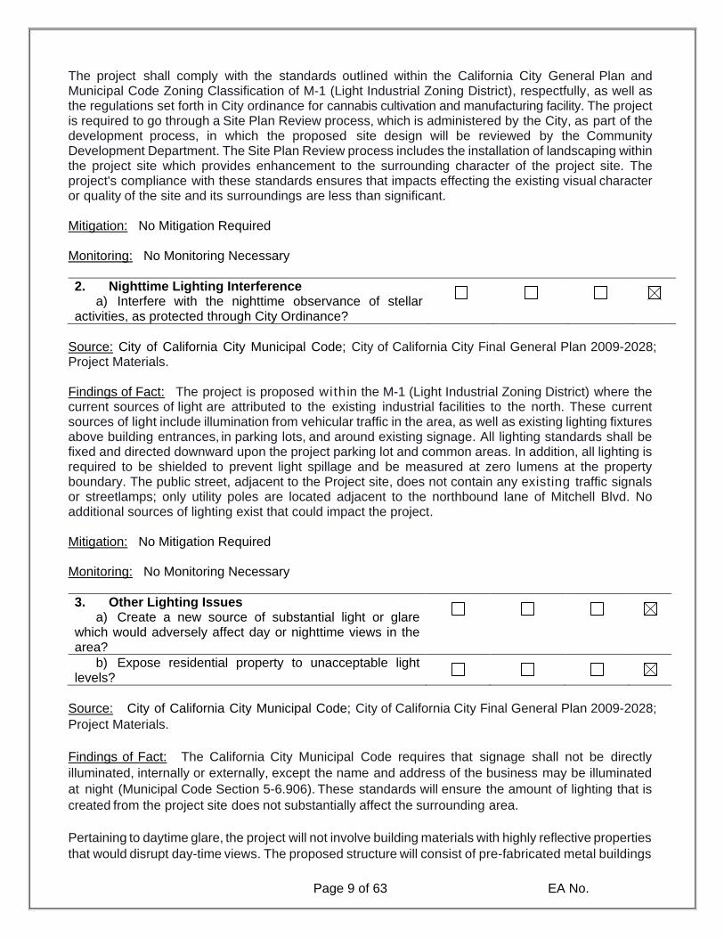
The project shall comply with the standards outlined within the California City General Plan and Municipal Code Zoning Classification of M-1 (Light Industrial Zoning District), respectfully, as well as the regulations set forth in City ordinance for cannabis cultivation and manufacturing facility. The project is required to go through a Site Plan Review process, which is administered by the City, as part of the development process, in which the proposed site design will be reviewed by the Community Development Department. The Site Plan Review process includes the installation of landscaping within the project site which provides enhancement to the surrounding character of the project site. The project's compliance with these standards ensures that impacts effecting the existing visual character or quality of the site and its surroundings are less than significant. Mitigation: No Mitigation Required Monitoring: No Monitoring Necessary
2. Nighttime Lighting Interference a) Interfere with the nighttime observance of stellar
activities, as protected through City Ordinance?
Source: City of California City Municipal Code; City of California City Final General Plan 2009-2028; Project Materials. Findings of Fact: The project is proposed within the M-1 (Light Industrial Zoning District) where the current sources of light are attributed to the existing industrial facilities to the north. These current sources of light include illumination from vehicular traffic in the area, as well as existing lighting fixtures above building entrances, in parking lots, and around existing signage. All lighting standards shall be fixed and directed downward upon the project parking lot and common areas. In addition, all lighting is required to be shielded to prevent light spillage and be measured at zero lumens at the property boundary. The public street, adjacent to the Project site, does not contain any existing traffic signals or streetlamps; only utility poles are located adjacent to the northbound lane of Mitchell Blvd. No additional sources of lighting exist that could impact the project. Mitigation: No Mitigation Required Monitoring: No Monitoring Necessary
3. Other Lighting Issues a) Create a new source of substantial light or glare
which would adversely affect day or nighttime views in the area?
b) Expose residential property to unacceptable light levels?
Source: City of California City Municipal Code; City of California City Final General Plan 2009-2028;
Project Materials.
Findings of Fact: The California City Municipal Code requires that signage shall not be directly
illuminated, internally or externally, except the name and address of the business may be illuminated
at night (Municipal Code Section 5-6.906). These standards will ensure the amount of lighting that is
created from the project site does not substantially affect the surrounding area.
Pertaining to daytime glare, the project will not involve building materials with highly reflective properties
that would disrupt day-time views. The proposed structure will consist of pre-fabricated metal buildings
Potentially Significant
Impact
Less than Significant
with Mitigation
Incorporated
Less Than
Significant Impact
No Impact
Page 10 of 63 EA No.
with beige, brown and off-white colored stucco and glint-and-glare resistant windows located within
the building’s façade. The proposed use will not substantially increase glint, glare, or light pollution
given the small size of the property, the relatively small footprint or the use, and the minimum amount
of exterior lighting required. Notwithstanding this minimal impact, the project shall comply with City
standards regarding lighting and glare in industrial facilities and M-1 zones. Therefore, less than
significant impacts are anticipated to result from the proposed project.
Mitigation: No Mitigation Required Monitoring: No Monitoring Necessary
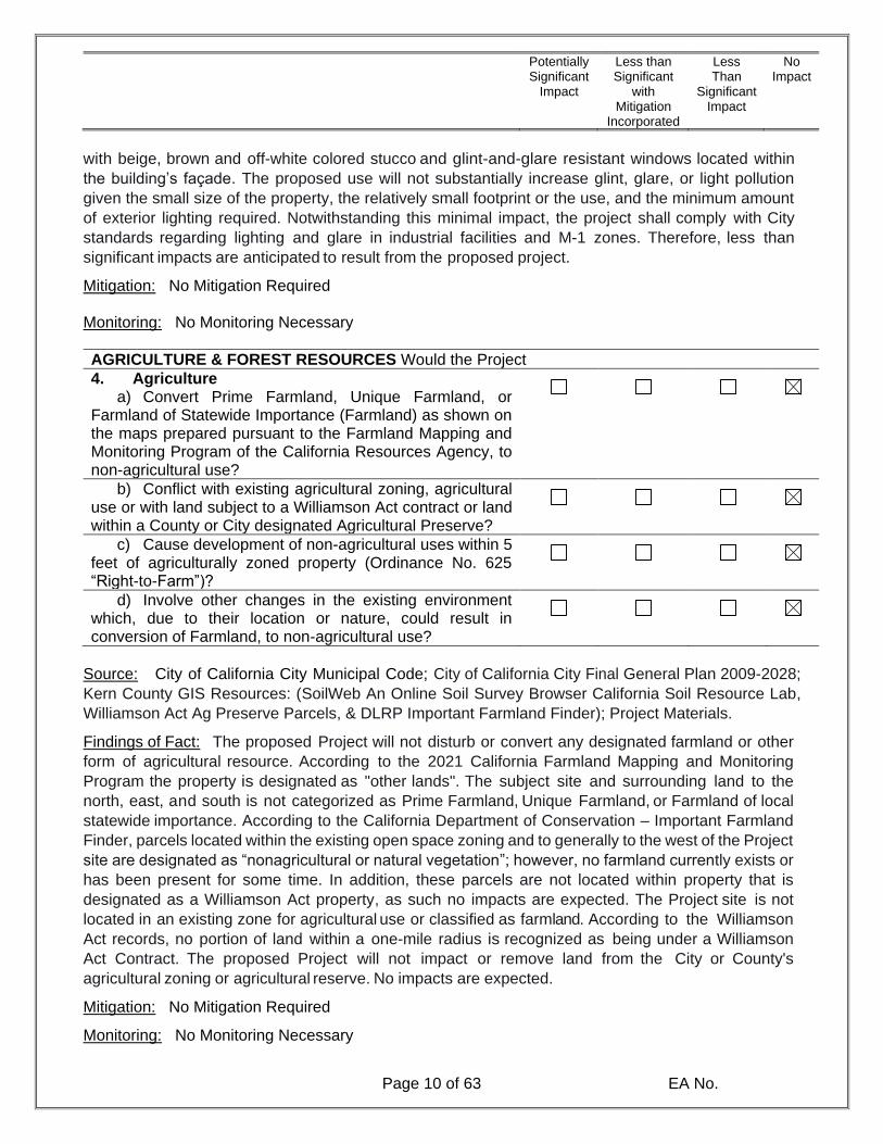
AGRICULTURE & FOREST RESOURCES Would the Project
4. Agriculture a) Convert Prime Farmland, Unique Farmland, or
Farmland of Statewide Importance (Farmland) as shown on the maps prepared pursuant to the Farmland Mapping and Monitoring Program of the California Resources Agency, to non-agricultural use?
b) Conflict with existing agricultural zoning, agricultural use or with land subject to a Williamson Act contract or land within a County or City designated Agricultural Preserve?
c) Cause development of non-agricultural uses within 5 feet of agriculturally zoned property (Ordinance No. 625 “Right-to-Farm”)?
d) Involve other changes in the existing environment which, due to their location or nature, could result in conversion of Farmland, to non-agricultural use?
Source: City of California City Municipal Code; City of California City Final General Plan 2009-2028;
Kern County GIS Resources: (SoilWeb An Online Soil Survey Browser California Soil Resource Lab,
Williamson Act Ag Preserve Parcels, & DLRP Important Farmland Finder); Project Materials.
Findings of Fact: The proposed Project will not disturb or convert any designated farmland or other
form of agricultural resource. According to the 2021 California Farmland Mapping and Monitoring
Program the property is designated as "other lands". The subject site and surrounding land to the
north, east, and south is not categorized as Prime Farmland, Unique Farmland, or Farmland of local
statewide importance. According to the California Department of Conservation – Important Farmland
Finder, parcels located within the existing open space zoning and to generally to the west of the Project
site are designated as “nonagricultural or natural vegetation”; however, no farmland currently exists or
has been present for some time. In addition, these parcels are not located within property that is
designated as a Williamson Act property, as such no impacts are expected. The Project site is not
located in an existing zone for agricultural use or classified as farmland. According to the Williamson
Act records, no portion of land within a one-mile radius is recognized as being under a Williamson
Act Contract. The proposed Project will not impact or remove land from the City or County's
agricultural zoning or agricultural reserve. No impacts are expected.
Mitigation: No Mitigation Required
Monitoring: No Monitoring Necessary

Potentially Significant
Impact
Less than Significant
with Mitigation
Incorporated
Less Than
Significant Impact
No Impact
Page 11 of 63 EA No.
5. Forest a) Conflict with existing zoning for, or cause rezoning of,
forest land (as defined in Public Resources Code section 12220(g)), timberland (as defined by Public Resources Code section 4526), or timberland zoned Timberland Production (as defined by Govt. Code section 5154(g))?
b) Result in the loss of forest land or conversion of forest land to non-forest use?
c) Involve other changes in the existing environment which, due to their location or nature, could result in con-version of forest land to non-forest use?
Source: City of California City Municipal Code; City of California City Final General Plan 2009-2028;
Project Materials.
Findings of Fact: The Project is located within an existing urbanizing desert environment that is
currently zoned for industrial uses. The Project site, and the surrounding vicinity, does not contain any
forest land, timberland or Timberland Production Zones (TPZ) that have occurred or will occur on the
Project site or in the surrounding area because forest vegetation is not characteristic of the Eastern
Kern County desert environment. No impacts are anticipated. The Project will occur in an existing
urban desert setting zoned for industrial uses. No forest land, timberland or Timberland Production
zoning occurs on the Project site or in the surrounding area because forest vegetation is not
characteristic of the Eastern Kern County desert environment. No impacts are anticipated. As
previously described, the Project site and vicinity are designated by the California City General Plan
and Zoning map as Light Industrial and Research. The proposed indoor cultivation and processing
facilities will not result in conversion of any farmland or forest land because no farmland or forest land
is situated within or adjacent to the Project. No impacts are anticipated.
Mitigation: No Mitigation Required
Monitoring: No Monitoring Necessary
Would the Project
6. Air Quality Impacts a) Conflict with or obstruct implementation of the
applicable air quality plan?
b) Violate any air quality standard or contribute substantially to an existing or Projected air quality violation?
c) Result in a cumulatively considerable net increase of any criteria pollutant for which the Project region is non-attainment under an applicable federal or state ambient air quality standard (including releasing emissions which exceed quantitative thresholds for ozone precursors)?
d) Expose sensitive receptors which are located within 1 mile of the Project site to Project substantial point source emissions?
e) Involve the construction of a sensitive receptor located within one mile of an existing substantial point source emitter?

Potentially Significant
Impact
Less than Significant
with Mitigation
Incorporated
Less Than
Significant Impact
No Impact
Page 12 of 63 EA No.
f) Create objectionable odors affecting a substantial number of people?
Source: Source: City of California City Municipal Code; City of California City Final General Plan 2009-2028; Project Materials; Kern County Air Pollution Control District (EKAPCD). Findings of Fact: California City is located within the Mojave Desert Air Basin and is under the
jurisdiction of the Kern County Air Pollution Control District (EKAPCD). There are over 3,700-square
miles in the eastern portion that Kern County APCD controls, located on the western edge of the
Mojave Desert. The high summer temperatures and radiation from the sun can encourage
photochemical ozone formation when local sources or transported volatile organic compounds
(VOC's) and oxides of Nitrogen (NOx) precursors are present. Kern County is within the jurisdiction of
both the San Joaquin Valley Air Pollution Control District (SJVAPCD) in the San Joaquin Valley Air
Basin (SJVAB) and the Eastern Kern Air Pollution Control District (EKAPCD) in the Mojave Desert
Air Basin (MOAB).
Projects are evaluated for consistency with the local air quality management plans, which link local
planning and individual Projects to the regional plans developed to meet the ambient air quality
standards. The assessment takes into consideration whether the Project forms part of the expected
conditions identified in local plans (General Plan Land Use and Zoning) and whether the Project adheres
to the City's air quality goals, policies, and local development assumptions factored into the regional
California Air Resources Board (CARB). As previously discussed, the undeveloped Project property
has a Light Industrial Zoning ( M - 1 ) District classification, which has been established to permit
the development of a wide spectrum of industrial and manufacturing uses. In its current condition, the
undeveloped Project site is surrounded by mostly vacant land and is not located within proximity of
existing residential uses or other densely populated areas of the City or County. The Project will not
require a General Plan Amendment or other revision that would provide directly or indirectly for
increased population growth above the level projected in the adopted California Air Resources Board.
The Project will not interfere with the ability of the region to comply with federal and state ambient
air quality standards. Projects that are consistent with local General Plans are considered consistent
with the air quality related regional plans including the current CARB, the PM-10 and other applicable
regional plans. The proposed Project is a permitted use in the existing zone and shall comply with
the corresponding development standards. Development is consistent with the growth projections in
the City of California City General Plan and is to be consistent with CARB.
The Project would not result in or cause violations to the National Ambient Air Quality Standards
or California Ambient Air Quality Standards. The Project's proposed land use designation for the
subject site does not materially affect the uses allowed or their development intensities as reflected in the
adopted City General Plan. The Project is therefore considered to be consistent with the AQMP and
impacts related to air quality plans are expected to be less than significant following implementation of
standard conditions within the plan and including but not limited to:
• Development of the proposed Project will comply with the provisions of Eastern Kern County
Air Pollution District.
• A Fugitive Dust Control Plan will be prepared for the Project outlining required control
measures throughout all stages of construction.

Potentially Significant
Impact
Less than Significant
with Mitigation
Incorporated
Less Than
Significant Impact
No Impact
Page 13 of 63 EA No.
In the event that the electricity purveyor (Southern California Edison) cannot immediately supply
service concurrently with the City’s issuance of occupancy permits and business licenses, the project
may utilize on-site generators to achieve operational capacity prior to full electrification by SCE. In this
circumstance, the project anticipates the utilization of a 5.8 kHP, 8.1LT, 125 kWe 6-Cylinder Inline
generator, to provide temporary power in lieu of delaying project operations and awaiting the
completion of infrastructure development by Southern California Edison (SCE). The proposed
generator will operate 8-hours per day for at-least one year (351 days), with approximately 1,920
operational hours per year. While the timeframe of electrical infrastructure by SCE is undetermined,
the generator being utilized has already undergone a rigorous certification process by CalEPA and
CARB for commercial use in the manner described. In addition, an air quality (CalEEMod) analysis
was completed, and the results are described below in Table 1-1. The proposed generator does not
exceed the daily thresholds for criteria pollutants as set forth by the Kern County/Mohave Air District.
TABLE 1-1: PROJECT CONSTRUCTION EMISSIONS (Unmitigated)
Pollutant Daily Maximum Emissions (lbs./day)
EKAPCD Maximum
Daily Threshold* (lbs./day)
Exceeds EKAPCD Threshold?
Reactive Organic Gas (ROG) 128.28 137 NO
Oxides of Nitrogen (NOx) 20.24 137 NO
Carbon Monoxide (CO) 15.84 548 NO
PM2.5 4.23 82 NO
SO2 0.03 148 NO
*Source: CalEEMod v2016.3.1. & http://www.kernair.org/Main_Pages/Subpages/Rules_Sub/CEQA_Guidelines.html
TABLE 1-2: PROJECT OPERATION EMISSIONS (Unmitigated)
Pollutant Daily Maximum Emissions (lbs./day)
EKAPCD Maximum
Daily Threshold* (lbs./day)
Exceeds EKAPCD Threshold?
Reactive Organic Gas (ROG) 3.4 137 YES
Oxides of Nitrogen (NOx) 12.42 137 NO
Carbon Monoxide (CO) 10.50 548 NO
PM2.5 1.02 82 NO
SOx 0.64 148 NO
*Source: CalEEMod v2016.3.1. & http://www.kernair.org/Main_Pages/Subpages/Rules_Sub/CEQA_Guidelines.html
Consequently, the Project would not substantially contribute to a significant individual or cumulative
impact on existing or projected exceedances of the state or federal ambient air quality standards or
result in a cumulatively considerable net increase in the emissions of any criteria pollutant for which the
Project region is designated nonattainment. Less than significant impacts are anticipated.
Potentially Significant
Impact
Less than Significant
with Mitigation
Incorporated
Less Than
Significant Impact
No Impact
Page 14 of 63 EA No.
Mitigation:
AQ1: Article 11, Section 5-6.151 of the City Municipal Code requires the reduction and elimination of
odors resulting from the processing, cultivation, and the commercial sale of cannabis and cannabis
related products. The Project is required to implement, maintain in good repair, and comply with City
monitoring and enforcement as necessary. Furthermore, compliance with City Code is required of all
projects and is not considered unique mitigation.
AQ2: The project proponent shall install a sign, no less than four feet by eight feet in area, and no more
than six feet in height. The sign shall provide the name and number of a 24/7 contact for concerns
relating to construction noise or dust.
Monitoring: The City Code Enforcement Department will monitor and enforce odor, noise, and other
similar complaints. The City Planning Division will monitor compliance of the mitigation measures et
forth in the CalEEMOD report and analysis.
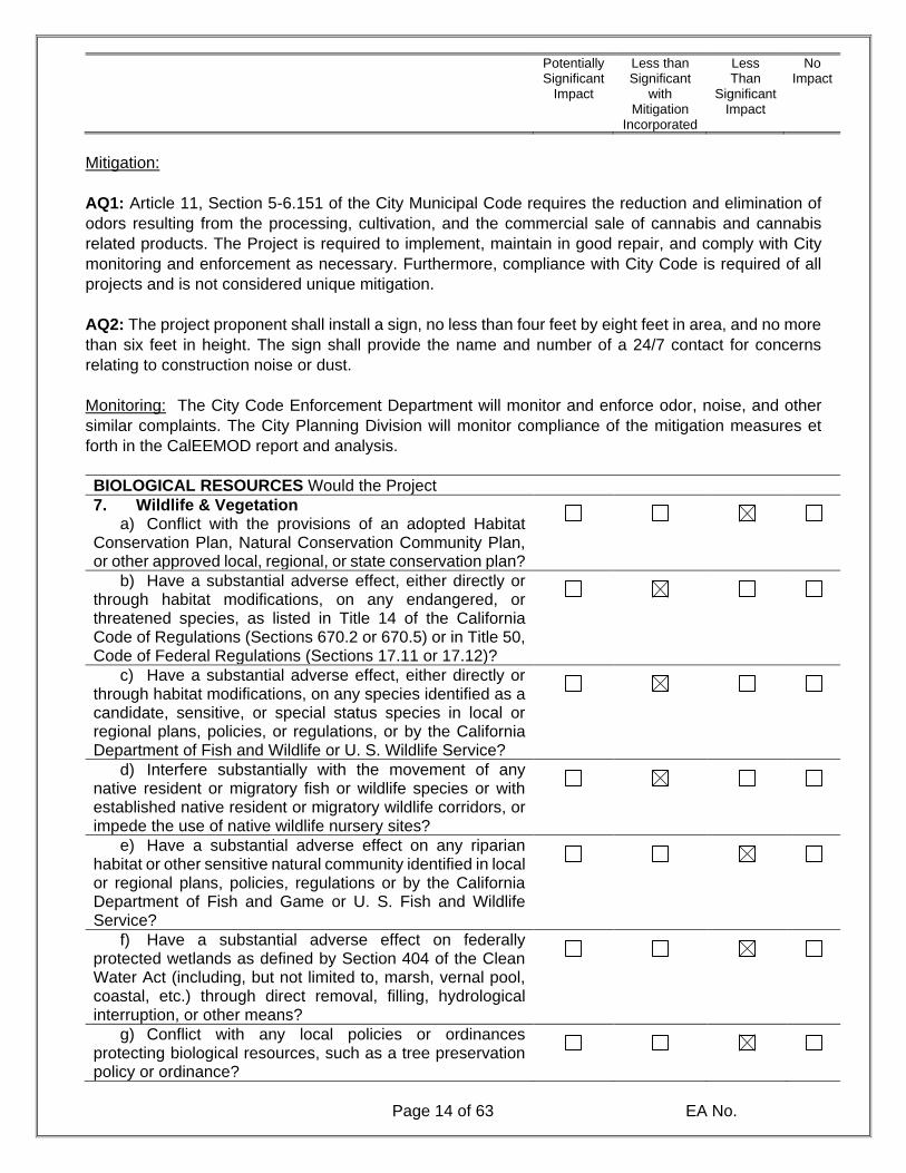
BIOLOGICAL RESOURCES Would the Project
7. Wildlife & Vegetation a) Conflict with the provisions of an adopted Habitat
Conservation Plan, Natural Conservation Community Plan, or other approved local, regional, or state conservation plan?
b) Have a substantial adverse effect, either directly or through habitat modifications, on any endangered, or threatened species, as listed in Title 14 of the California Code of Regulations (Sections 670.2 or 670.5) or in Title 50, Code of Federal Regulations (Sections 17.11 or 17.12)?
c) Have a substantial adverse effect, either directly or through habitat modifications, on any species identified as a candidate, sensitive, or special status species in local or regional plans, policies, or regulations, or by the California Department of Fish and Wildlife or U. S. Wildlife Service?
d) Interfere substantially with the movement of any native resident or migratory fish or wildlife species or with established native resident or migratory wildlife corridors, or impede the use of native wildlife nursery sites?
e) Have a substantial adverse effect on any riparian habitat or other sensitive natural community identified in local or regional plans, policies, regulations or by the California Department of Fish and Game or U. S. Fish and Wildlife Service?
f) Have a substantial adverse effect on federally protected wetlands as defined by Section 404 of the Clean Water Act (including, but not limited to, marsh, vernal pool, coastal, etc.) through direct removal, filling, hydrological interruption, or other means?
g) Conflict with any local policies or ordinances protecting biological resources, such as a tree preservation policy or ordinance?

Potentially Significant
Impact
Less than Significant
with Mitigation
Incorporated
Less Than
Significant Impact
No Impact
Page 15 of 63 EA No.
Source: City of California City Municipal Code; City of California City Final General Plan 2009-2028;
General Biological Resources Assessment & Endangered Species Report (dated September 1, 2020);
Project Materials.
Findings of Fact: A Biological Assessment was conducted in September of 2020 and as part of this assessment, the lead biologist prepared a line transect survey to inventory biological resources potentially available on-site. The proposed project area was characteristic of a highly impacted desert field. A total of twenty-three (23) plant species and fifteen (15) wildlife species or their sign were observed during the line transect survey. However, in regard to particular species of concern that are currently established as threatened or endangered species on identified at either the federal or state level, none were observed. More specifically, no desert tortoises (Gopherus agassizii) or their sign were observed within the study area. The study site did not provide suitable habitat for Desert Tortoises (DT) or Mohave Ground Squirrels (MGS) (Xerospermophilus mohavensis). No desert Kit Fox dens were identified on-site, or within the Project survey boundary. No burrowing owls (Athene cunicularia), or their sign were observed during the field survey. California ground squirrel burrows (Citellus beecheyi) were observed within the study area. California ground squirrel burrows can provide potential future cover sites for burrowing owls. Sensitive plants, specifically, alkali mariposa lily (Calochortus striatus), desert cymopterus (Cymopterus deserticola), and Barstow woolly sunflower (Eriophyllum mohanense) are not expected to occur within the study area due to lack of suitable habitat. Prairie falcons (Falco mexicanus) and other raptors may fly over the site, but there are no nesting or roosting opportunities available within the study site. Migratory birds would not be expected to nest in the limited vegetation within the study site. No state or federally listed species are expected to occur within the proposed project area. No ephemeral streams or washes were present within the study area. (a) Conflict with the provisions of an adopted Habitat Conservation Plan, Natural Conservation
Community Plan, or other approved local, regional, or state conservation plan?
The California Department of Fish & Wildlife (CDFW) began planning for the establishment of, and
acquisition of private lands for the conservation of the Mohave Ground Squirrel (MGS). In 2007,
CDFW determined that an essential component of any conservation strategy, for the state-listed
MGS. The service has identified four “core areas” that have historically supported relatively
abundant and widespread MGS populations. There is evidence that these populations will continue
to persist given adequate conservation efforts and mitigation strategies. As a Land Mitigation Bank
does not currently exist, mitigation credits are reserved for future conservation efforts. The four core
areas currently recognized are detailed as follows:
(i) Coso Range NW to Olancha. Most of the area is within the China Lake NAWS military
reservation, with a mixture of BLM, LADWP, and private lands to the west (Inyo County).
(ii) Little Dixie Wash (from Inyokern SW to Red Rock Canyon State Park). Most of the area is
publicly managed by BLM, with some private and state ownerships as well (Kern County).
(iii) Edwards Air Force Base, east of Rogers Dry Lake. This core area is entirely on the United States
Air Force (USAF) military reservation; the surrounding lands are in private and BLM ownership
(Kern and San Bernardino County).
(iv) Coolgardie Mesa to Superior Valley. Land ownership was primarily BLM and in private
ownership; however, much f the northern portion of this core area is not included within the Fort
Irwin Wester Expansion Area (WEA) (San Bernardino County).

Potentially Significant
Impact
Less than Significant
with Mitigation
Incorporated
Less Than
Significant Impact
No Impact
Page 16 of 63 EA No.
The Project is located approximate 40-miles from the Little Dixie Wash conservation area, which is
sufficient distance removed from the conservation area. CDFW provides additional analysis to support
this potential incremental impact upon MGS habitat, through their Mohave Ground Squirrel Technical
Advisory Group (MSG TAG); which is a long-standing committee of MGS technical experts, land
management, and regulatory agencies. That being said CDFW remains concerned that the urbanizing
effects of the Project will contribute to the diminishment; albeit incremental, upon the MGS habitat. The
TAG published a list of conservation priorities in December of 2010 and sets forth five primary
conservation priorities intended to support the ongoing conservation of the MGS. These priorities are
detailed as follows1:
1) Maintain Functional Habitat Connections between Known Populations
2) Protect Known Core Areas
3) Identify Development Zones with Minimal Impact on MGS Habitat
4) Conduct Research to Clarify the Distribution and Status of the MGS
5) Conduct Research to Improve Mohave Ground Squirrel Detection Capabilities
b) – g) A Biological Assessment was conducted in November of 2020 and as part, a habitat assessment/field survey was prepared. This assessment is incorporated herein by reference, to confirm existing site conditions within the project site. The lead biologist extensively surveyed all special-status habitats and/or natural areas, where accessible, which have a higher potential to support special-status plant and wildlife species. Vegetation communities occurring within the project site were mapped on an aerial photograph and classified in accordance with the vegetation descriptions provided in A Manual of California Vegetation (Sawyer et al., 2009) and cross referenced with the Preliminary Descriptions of the Terrestrial Natural Communities of California (Holland, 1986). In addition, site characteristics such as soil condition, topography, hydrology, anthropogenic disturbances, indicator species, condition of on-site vegetation communities, and the presence of potentially regulated jurisdictional features were noted. Mark Hagan Biological used Geographic Information Systems (GIS) ArcView software to digitize the mapped vegetation communities and then transferred these data onto an aerial photograph to further document existing conditions and quantify the acreage of each vegetation community. A line transect survey was conducted on June 10, 2020 to inventory biological resources. The proposed project area was characteristic of a disturbed creosote bush (Larrea tridentata) scrub plant community. A total of fifteen (15) plant species and eight (8) wildlife species or their sign were observed during the line transect survey. No desert tortoises (Gopherus agassizii) or their sign were observed during the field survey. No Mohave ground squirrels (Xerospermophilus mohavensis) were observed or audibly detected during the field survey. Schismus (sp.), an invasive grass species that appears to be an indicator of poor Mohave ground squirrel habitat, is the dominant annual within and adjacent to the study site. Mohave ground squirrels are not expected due to lack of required forage and cover plant species. The additional details, regarding the Habitat Assessment methodology, can be found in the attached Biological Assessment Report, prepared by Mark Hagan Biological, dated June 10, 2020.
The Biological Assessment indicated that natural habitats (within the project site) have been disturbed as a result of previous grading activities, resulting in a disturbed rubber rabbitbrush vegetation community and heavily disturbed/compacted surface soils throughout. No special-status plant species were observed during the field survey. The disturbed nature of the project site has reduced the potential for it to provide suitable habitat for special-status plant species. Based on the results of the habitat assessment and a review of specific habitat preferences, distributions, and elevation ranges, it was
1 https://nrm.dfg.ca.gov/FileHandler.ashx?DocumentID=83973&inline

Potentially Significant
Impact
Less than Significant
with Mitigation
Incorporated
Less Than
Significant Impact
No Impact
Page 17 of 63 EA No.
determined that special-status plant species identified by the CNDDB and CNPS Online Inventory database are not expected to occur within the project site. The project site and surrounding vegetation communities provide limited suitable foraging and nesting habitat for a variety of year-round and seasonal avian residents as well as migrating songbirds that could occur in the area. Nesting birds are protected under the MBTA, the Bald and Golden Eagle Protection Act, and the CFGC. If project-related activities are to be initiated during the nesting season (January 1st to August 31st), a pre-construction nesting bird clearance survey should be conducted by a qualified biologist no more than three (3) days prior to the start of any vegetation removal or ground disturbing activities. The qualified biologist shall survey all suitable nesting habitat within the project impact area, and areas within a biologically defensible buffer zone surrounding the project impact area. If no active nests are detected during the clearance survey, project activities may begin, and no additional avoidance and minimization measures would be required. If an active nest is found, the bird species shall be identified, and a “non-disturbance” buffer should be established around the active nest. The size of the “non-disturbance” buffer should be increased or decreased based on the judgement of the qualified biologist and level of activity and sensitivity of the species. It is further recommended that the qualified biologist periodically monitor any active nests to determine if project-related activities occurring outside the “no-disturbance” buffer disturb the birds and if the buffer should be increased. Once the young have fledged and left the nest, or the nest otherwise becomes inactive under natural conditions, project activities within the “no-disturbance” buffer may occur. Although not identified in the CNDDB database search of the USGS California City North, California City South, Mojave NE, and Sanborn, California 7.5-minute quadrangles, California horned lark was the only special-status wildlife species observed during the field survey. Based on the results of the habitat assessment and a review of specific habitat preferences, occurrence records, known distributions, and elevation ranges, it was determined that the project site has a moderate potential to support burrowing owl, prairie falcon, and loggerhead shrike; and a low potential to support Mohave ground squirrel. All remaining special-status wildlife species identified by the CNDDB database are not expected to occur within the project site. Due to the proximity of the project site to existing occurrence records for burrowing owl, pre-construction burrowing owl clearance surveys should be conducted by a qualified biologist to ensure that burrowing owls remain absent from the project site and impacts to burrowing owls do not occur. In accordance with the Staff Report on Burrowing Owl Mitigation (CDFW, 2012), two (2) pre-construction clearance surveys should be conducted 14-30 days and 24 hours prior to any vegetation removal or ground disturbing activities. Documentation of surveys and findings shall be submitted to the City of California City for review and file. If no burrowing owls or occupied burrows are detected, project activities may begin. If an occupied burrow is found within the development footprint during pre-construction clearance surveys, a burrowing owl exclusion and mitigation plan will need to be prepared and submitted to CDFW for approval prior to initiating project activities. Although Burrowing Owl was not observed during the field survey, the project site is located within the immediate vicinity of areas that do have the potential for sufficient habitat to occur, even though no owls have been observed. provides marginal habitat and occurs within the vicinity of known populations. The Project is found to have a less than significant impact, upon biological resources, with the following mitigation measures incorporated.
Potentially Significant
Impact
Less than Significant
with Mitigation
Incorporated
Less Than
Significant Impact
No Impact
Page 18 of 63 EA No.
Mitigation: BIO 1: The Project proponent shall conduct two (2) pre-construction clearance surveys should be conducted 14-30 days and 24 hours prior to any vegetation removal or ground disturbing activities. Documentation of surveys and findings shall be submitted to the City of California City for review and file. If no burrowing owls or occupied burrows are detected, project activities may begin. If an occupied burrow is found within the development footprint during pre-construction clearance surveys, a burrowing owl exclusion and mitigation plan will need to be prepared and submitted to CDFW for approval prior to initiating project activities. BIO 2: If positive findings are determined, through the pre-construction surveys conducted under Mitigation Measure BIO 1, which qualify as suitable habitat is observed, and/or the presence of endangered or threatened species is also observed, then the Project proponent shall conduct the appropriate protocol surveys, prior to any development occurs within the project site to confirm the presence/absence of said species. Protocol surveys shall consist of three (3) separate 5-night trapping sessions conducted during specific terms between March 15th and July 15th. BIO 3: If the protocol surveys conducted as part of Mitigation Measure BIO 2 and qualifying species are found to occupy the project site and/or the construction clearance areas of the Project site, then proponent shall file for, and process to completion, an Incidental Take Permit, in compliance with CDFW’s discretionary authority as defined by Title 14 of the California Code of Regulations (Section 15357 of the CEQA Guidelines). Under this Incidental Take Permit, CDFE will review and determine the necessary minimization and mitigation measures; including, but not limited to, the purchase of credits from a CDFW approved conservation or mitigation bank.2 Monitoring: The California Department of Fish and Wildlife (CDFW) will monitor and establish the mitigation/conservation credit agreement and the City of California City shall monitor the grading permit process and require written clearance, from CDFW, prior to the issuance of a grading permit.
CULTURAL RESOURCES Would the Project
8. Historic Resources a) Alter or destroy an historic site?
b) Cause a substantial adverse change in the significance of a historical resource as defined in California Code of Regulations, Section 15064.5?
Source: City of California City Municipal Code; City of California City Final General Plan 2009-2028; Project Materials.
Findings of Fact: The project is located on approximately 5-acres of undeveloped land within the M-1 (Light Industrial Zoning District), within California City. The M-1 land use designation provides a broad spectrum of industrial, and manufacturing uses that do not have the potential for detrimental impacts on surrounding properties. Existing manufacturing establishments in the vicinity are located north and west of the project site, including the California City Municipal Airport and a storage company. According to the California City General Plan, historic resources are items that are at least 45 years of age or older that also represents a significant time, place, origin, event, or work of a master. Historic resources may be identified as structures and as archaeological sites. Five historic archaeological sites are recorded within the City. Recorded historic sites included trash scatter, glass
2 https://wildlife.ca.gov/Conservation/Planning/Banking/Approved-Banks

Potentially Significant
Impact
Less than Significant
with Mitigation
Incorporated
Less Than
Significant Impact
No Impact
Page 19 of 63 EA No.
and ceramics and potential WWII desert training or military disposal items. As referenced within the Historic and Cultural resources of the General Plan none of these findings were eligible for inclusion under the California State Office of Historic Preservation (SOHP). The site is vacant, and no historic structures or features have been identified on or adjacent to the project site. In addition, there are no recognizable potential historic resources, as defined in Section 15064.5 of the CEQA Guidelines that would be adversely affected by the proposed project. This includes any object, building, structure, site, area, place, record, or manuscript which a lead agency determines to be historically significant. Less than significant impacts are anticipated.
Mitigation: No Mitigation Required Monitoring: No Monitoring Necessary
9. Archaeological Resources a) Alter or destroy an archaeological site.
b) Cause a substantial adverse change in the significance of an archaeological resource pursuant to California Code of Regulations, Section 15064.5?
c) Disturb any human remains, including those interred outside of formal cemeteries?
d) Restrict existing religious or sacred uses within the potential impact area?
e) Cause a substantial adverse change in the significance of a tribal cultural resource as defined in Public Resources Code 2574?
Source: City of California City Municipal Code; City of California City Final General Plan 2009-2028;
Project Materials.
Findings of Fact: The approximately 5-acre project site is characterized by relatively flat, undisturbed
desert land, with scattered vegetation. The Project is located in the M-1 (Light Industrial Zoning District)
within the City of California City. The Project site is not recognized as a unique archeological
features; a site where former human remains, including those interred outside of formal cemeteries,
have been identified or located; or a site that contains any existing religious or sacred uses. However,
per the California City General Plan, if a unique archeological resource or site or human remains
are found during excavation, all work will be suspended until the area has been thoroughly examined.
Pursuant to the California Health and Safety Code Section 7050.5, and the CEQA Guidelines Section
15064.5, in the event of discovery or recognition of any human remains in any location other than
a dedicated cemetery, there shall be no further excavation or disturbance of the site, or any nearby
area reasonably suspected to overlay adjacent remains, until the County Coroner has examined the
remains. If the coroner determines the remains to be Native America or has reason to believe that
they are Native American, the coroner shall contact by telephone within 24-hours of the Native
American Heritage Commission. Pursuant to the mentioned California Health and Safety Code,
proper actions shall take place in the event of a discovery or recognition of any human remains
during project construction activities. Less than significant impacts are expected following the standard
conditions which do not address any unique circumstances regarding the proposed site.

Potentially Significant
Impact
Less than Significant
with Mitigation
Incorporated
Less Than
Significant Impact
No Impact
Page 20 of 63 EA No.
Findings of Fact: As previously discussed in the Cultural Resources section, there are five recorded
historic archaeological sites within the City, according to the California City General Plan. These
archaeological sites are not found within the project area. The cultural resource survey was concluded
that no cultural resources were found on the project site or with close proximity to the site
(discussed in Cultural Resources: Sections 8-9). The historical, cultural and archaeological resources
surveys outlined within the California City General Plan indicate that the project site is not listed or
eligible for listing in the California Register of Historical Resources or in any local register. Therefore,
no impacts are anticipated with project implementation. As previously discussed in the Cultural
Resources discussion of this document, there are five recorded historic archaeological sites within the
City, according to the California City General Plan. The archaeological sites are not found within the
project area.
Therefore, no impacts are anticipated with project implementation. As previously discussed, the land
surveys prepared for the California City General Plan did not indicate the presence of historic
resources, cultural resources, and archaeological resources on or near the project site. The California
City General Plan states that the City had no Native American Sacred Sites within the City's boundary.
Therefore, project implementation is not expected to have a substantial adverse change in a significant
Tribal cultural resource. Less than significant impacts are anticipated.
Mitigation: No Mitigation Required Monitoring: No Monitoring Necessary
46. Energy Conservation a) Would the Project conflict with any adopted energy conservation plans?
Source: City of California City Municipal Code; City of California City Final General Plan 2009-2028;
California City General Plan Open Space Element.
Findings of Fact: The project will reduce its GHG emissions to the maximum extent feasible through
energy conservation measures and implementation of the current California Green Building Standards
Code in addition to the use of natural light for plant growth and water efficient irrigation for irrigation and
landscape design. No impact is anticipated to adopted Energy Conservation plans.
Mitigation: No Mitigation Required
Monitoring: No Monitoring Necessary
GEOLOGY AND SOILS Would the Project
10. Alquist-Priolo Earthquake Fault Zone or City/County Fault Hazard Zones
a) Expose people or structures to potential substantial adverse effects, including the risk of loss, injury, or death?
b) Be subject to rupture of a known earthquake fault, as delineated on the most recent Alquist-Priolo Earthquake
Potentially Significant
Impact
Less than Significant
with Mitigation
Incorporated
Less Than
Significant Impact
No Impact
Page 21 of 63 EA No.
Fault Zoning Map issued by the State Geologist for the area or based on other substantial evidence of a known fault?
Source: City of California City Municipal Code; City of California City Final General Plan 2009-2028; General Plan Safety Element; Department of Conservation; Project Materials. Findings of Fact: According to the Safety Element in the California City General Plan, a fault is defined as a fracture in the earth's crust forming a boundary between rock masses that have shifted. Fault rupture is a break in the ground's surface and associated deformation resulting from the movement of a fault. Rupture would be a potential problem within California City if a strong earthquake occurs along a known or unknown fault within or near the City. According to the California City General Plan, the City is not located in an Alquist Priolo Earthquake Fault Zone. The closest Alquist-Priolo Earthquake Fault Zone lies approximately 4.85 miles northwest of the project site, at the Garlock Fault.
According to the Safety Element, of the City’s General Plan, the project property shows no mapped
faults on-site per maps prepared by the California Geologic Survey and published by the International
Conference of Building Officials (ICBO). The project area is not located within an earthquake fault
zone, and no evidence of surface faulting was observed on the property during the site reconnaissance.
Per the findings within the California City General Plan and the project-specific Geotechnical
Investigation, surface fault rupture is considered unlikely at the project site. Less than significant impacts
are expected.
California City, and the project site, is located in the Mojave Block, also referred to as the Eastern California Shear Zone (ECSZ). The ECSZ is an area of increased seismic activity which stretches from the San Andreas Fault in the Coachella Valley, north-northeast across the Mojave Desert, and northward to the Owens Valley. The numerous faults in the region may accommodate as much as 5 to 20 percent of the relative motion between the North American and Pacific Plates, and according to the California City General Plan, the closest fault to the City is the Garlock Fault, which lies approximately 5 miles west of the City's core, and 4.15 miles northwest of the project property. The nearest significant active fault is the San Andreas Fault Zone, which is located approximately 37.8 miles from the proposed site. As a result, California City has the potential to experience seismic shaking and seismic-related hazards.
Mitigation: No Mitigation Required
Monitoring: No Monitoring Necessary
11. Liquefaction Potential Zone a) Be subject to seismic-related ground failure,
including liquefaction?
Source: City of California City Municipal Code; City of California City Final General Plan 2009-2028; General Plan Safety Element; Department of Conservation; Project Materials.
Findings of Fact: The Safety Element in the California City General Plan states that liquefaction is the phenomenon in which loose, saturated, granular soils temporarily behave similarly to a fluid when subjected to high intensity ground shaking. Liquefaction occurs when three general conditions are present: shallow groundwater, low-density, silty or fine sandy soils, and high intensity ground motion. Areas of shallow groundwater have a higher susceptibility to liquefaction; however, the groundwater in the City ranges from approximately 350 to 400 feet below ground level, according to the Existing Sewer System Map (Figure 3 – Groundwell #14) in the 2018 California City Local Agency
Potentially Significant
Impact
Less than Significant
with Mitigation
Incorporated
Less Than
Significant Impact
No Impact
Page 22 of 63 EA No.
Management Program for Onsite Wastewater Treatment Systems (OWTS), which results in a negligible impact from the effects of liquefaction. Per the findings within the California City General Plan, the potential for liquefaction occurring at the project site is considered low. Less than significant impacts are anticipated. Mitigation: No Mitigation Required Monitoring: No Monitoring Necessary
12. Ground-shaking Zone a) Be subject to strong seismic ground shaking?
Source: City of California City Municipal Code; City of California City Final General Plan 2009-2028;
General Plan Safety Element; Department of Conservation; Project Materials.
Findings of Fact: As the Project is in southern California, it is likely that the project site will experience
at least one moderate to severe earthquake and associated seismic shaking during the Project useable
life, as well as periodic slight to moderate earthquakes. In order to ensure the safety of the project site,
the proposed cultivation facility shall be constructed in a manner that reduces the risk of seismic hazards
(Title 24, California Code of Regulations). Standard Conditions of Approval require compliance with the
most current seismic design coefficients and ground motion parameters and all applicable provisions
of the 2019 California Building Code (CBC).
Mitigation: No Mitigation Required
Monitoring: No Monitoring Necessary
13. Landslide Risk a) Be located on a geologic unit or soil that is
unstable, or that would become unstable as a result of the Project, and potentially result in on- or off-site landslide, lateral spreading, collapse, or rockfall hazards?
Source: City of California City Municipal Code; City of California City Final General Plan 2009-2028;
General Plan Safety Element; Department of Conservation; Project Materials.
Findings of Fact: The California City Slope of Terrain Map in the General Plan (Figure 6-4) classifies
the project site's location as having. a 0 to 15 percent slope. The City lists two notable slopes within the
City being Galilee Hill and Twin Buttes, approximately 15-miles northeast and 6-miles southeast of the
project site, respectively. Moreover, there are no significant slopes proposed as part of the proposed
development; either on-site or being affected through any off-site grading activities. Based upon the
Project’s associated earthmoving activities, it is concluded that risks associated with slope instability
at the project property are considered low to negligible. In that vein, potential hazards associated
with landslide risks are unlikely at the project site and less than significant impacts are anticipated.
Mitigation: No Mitigation Required
Monitoring: No Monitoring Necessary
Potentially Significant
Impact
Less than Significant
with Mitigation
Incorporated
Less Than
Significant Impact
No Impact
Page 23 of 63 EA No.
14. Ground Subsidence a) Be located on a geologic unit or soil that is
unstable, or that would become unstable as a result of the Project, and potentially result in ground subsidence?
Source: City of California City Municipal Code; City of California City Final General Plan 2009-2028;
General Plan Safety Element; Department of Conservation; Project Materials.
Findings of Fact: The Safety Element in the California City General Plan states that land subsidence
is the gradual, local settling or sinking of the earth’s surface with little or no horizontal motion. Although
a seismic event can trigger subsidence, it can also occur as a result of gas, oil, or water extraction,
hydrocompaction, or peat oxidation. The southern portion of the Planning Area has been undergoing
gradual land subsidence, with up to four feet of subsidence over a 40-year period. Although subsidence
is not a significant hazard damage to wells, foundations, and underground utilities may occur. The
Project site is in the central to western portion of the City and is not as greatly affected by ground
subsidence as those properties located in the southern portions of the City.
Per the findings within the California City General Plan and the project-specific Geotechnical
Investigation, the potential for ground subsidence occurring at the project site is considered low.
Less than significant impacts are anticipated.
Mitigation: No Mitigation Required
Monitoring: No Monitoring Necessary
15. Other Geologic Hazards a) Be subject to geologic hazards, such as seiche,
mudflow, or volcanic hazard?
Source: City of California City Municipal Code; City of California City Final General Plan 2009-2028;
General Plan Safety Element; Department of Conservation; Project Materials.
Findings of Fact: The property is not subject to any additional geological hazard such as seiche,
mudflow, or volcanic hazard. As stated herein, the property is not located near, or within the general
vicinity of a lake or partially enclosed body of water which would be affected by oscillation in the water
level (e.g., seiche). As stated in the section on landslide risks, for which mudflow would be a concern.
Lastly, the Project is not located near or within a volcano.
Mitigation: No Mitigation Required
Monitoring: No Monitoring Necessary
16. Slopes a) Change topography or ground surface relief
features?
b) Create cut or fill slopes greater than 2:1 or higher than 5 feet?
c) Result in grading that affects or negates subsurface sewage disposal systems?

Potentially Significant
Impact
Less than Significant
with Mitigation
Incorporated
Less Than
Significant Impact
No Impact
Page 24 of 63 EA No.
Source: City of California City Municipal Code; City of California City Final General Plan 2009-2028;
General Plan Safety Element; Department of Conservation; Project Materials.
Findings of Fact: As stated in section 14a), previously, the California City Slope of Terrain Map in the
General Plan (Figure 6-4) classifies the project site's location as having. a 0 to 15 percent slope; which
is the category of least slope available in the City’s General Plan. The Project does not propose to alter
or modify the topography or ground surface feature in a way that will substantially alter the topography
or ground surface relief features; including changes that will possibly impact the operation of
subsurface sewage disposal systems. The Project also does not propose to create cut or fill slopes
greater than 2:1 or higher than 30-feet; therefore, risks associated with irregular or excessive slopes are
considered negligible.
Mitigation: No Mitigation Required
Monitoring: No Monitoring Necessary
17. Soils a) Result in substantial soil erosion or the loss of
topsoil?
b) Be located on expansive soil, as defined in Section 1802.3.2 of the California Building Code (2007), creating substantial risks to life or property?
c) Have soils incapable of adequately supporting use of septic tanks or alternative wastewater disposal systems where sewers are not available for the disposal of wastewater?
Source: City of California City Municipal Code; City of California City Final General Plan 2009-2028;
General Plan Safety Element; Department of Conservation; Project Materials.
Findings of Fact: As expansive soils dry, the soil shrinks; when moisture is reintroduced into the soil,
the soil swells. In order to reduce post-construction soil movement and provide uniform support for
the buildings to be constructed at the subject site, over excavation and recompaction within the
proposed building footprint areas should be performed to a minimum depth of five (5) feet blow existing
grades or three (3) feet below bottom of the proposed footing, whichever is deeper. Any undocumented
fill encountered during grading should be removed and replaced with engineered fill. Compliance with
the City’s General Plan Safety Element, construction of underground utilities will be required to
interconnect, and provide, water and sanitary sewer to the project site. According to the Existing Sewer
System Map (Figure 6) in the 2018 California City Local Agency Management Program for Onsite
Wastewater Treatment Systems (OWTS), a 12-inch sewer line currently exists along Mitchell
Boulevard, which the project will be required to make connection to and initiate service with the City
Public Works Department.
The construction site plan will utilize a portable toilet service in compliance with industry regulations
until the construction of the permanent facilities and connection to the existing infrastructure. Design
for all disposal systems shall comply with industry regulations, as well as the standards outlined in
Title 7, Chapter 2 within California City Municipal Code. No septic systems are proposed. Less
than significant impacts are anticipated.

Potentially Significant
Impact
Less than Significant
with Mitigation
Incorporated
Less Than
Significant Impact
No Impact
Page 25 of 63 EA No.
Mitigation: No Mitigation Required
Monitoring: No Monitoring Necessary
18. Erosion a) Change deposition, siltation, or erosion that may
modify the channel of a river or stream or the bed of a lake?
b) Result in any increase in water erosion either on or off site?
Source: City of California City Municipal Code; City of California City Final General Plan 2009-2028;
General Plan Safety Element; Department of Conservation; Project Materials.
Findings of Fact: The project is located within the Mojave Desert Air Basin (MOAB), under the
jurisdiction of the Eastern Kern Air Pollution Control District (EKAPCD). Air quality within this region
is influenced by the regional climate as well as the temperature, wind, humidity, precipitation, and
amount of sunshine. California City is in the high desert with an elevation range of 2,5 to 4,000 feet
above sea level. Its climate is semi-arid, rainfall for the area is less than 6 inches annually, which
provides for warm, dry weather in the summer and mild cooler weather in the winter.
The California City Erosion Hazards Map (Figure 6-3) within the General Plan displays most of the
City, including the project site, is in an area with none to slight erosion hazards. As previously stated,
the project site resides within the Eastern Kern Air Pollution Control District, therefore must comply with
the District’s Regulation IV, Rule 402. The purpose of this Rule is to prevent, reduce and mitigate
ambient concentrations of anthropogenic fugitive dust emissions to an amount sufficient to attain
and maintain the National Ambient Air Quality Standards (NAAQS) and California Ambient Air Quality
Standards (CAAQS). According to Regulation IV, Rule 402, the project shall implement one or more
fugitive dust emission control strategies, in order to limit visible dust emissions (VDE) to no more than
20-percent opacity or meet the conditions for a stabilized surface. Some control strategies include
applying dust suppressants, controlling vehicular speed, using water trucks, and implementing track-out
avoidance measures. The implementation of the fugitive dust emission control strategies will ensure
the reduction of ambient concentrations of fine particulate matter (PM2.5) by reducing or mitigating
anthropogenic fugitive dust emissions.
In addition to the Dust Control Plan, the project site is also required to implement a Stormwater Pollution
Prevention Plan (SWPPP) during the construction of the project, in order to comply with Environmental
Protection Agency (EPA) and the National Pollutant Discharge Elimination System (NPDES). The
purpose of the SWPPP is to develop a strategy for construction projects to minimize sediment and
other pollutants that may be expected to affect the quality of storm water discharges associated with
project development. The development and implementation of the SWPPP during project
construction will ensure that potential sources of pollution are identified and mitigated through the
application of best management practices (BMPs), such as concrete washouts or secondary
containment areas, further discussed in the Hydrology Section of this document.
Impacts of windborne and waterborne soil erosion at the project site will be controlled during project
operation after adequate paving, landscaping, and other means of stabilization is incorporated. The
proposed plan indicates that offsite run-on to the site is collected and conveyed through to retention
Potentially Significant
Impact
Less than Significant
with Mitigation
Incorporated
Less Than
Significant Impact
No Impact
Page 26 of 63 EA No.
basins in-between buildings, and underground retention facilities under the eastern parking lots, in
order to avoid onsite flooding. The drainage condition of the project site is subject to the completion of
percolation/infiltration studies conducted during the grading process. If infiltration is infeasible, the Regional
Water Quality Control Board Guidebook requires compliance with secondary or tertiary treatment
measures. Upon completion of the project, the site intends to have both hardscape and softscape
surfaces including the main industrial building and Project site landscaping including irrigation,
surrounding the buildings and project perimeter. Following the implementation of the fugitive dust
emission control strategies and the SWPPP, as well as the compliance with the adopted procedures
for grading, erosion at the project site is anticipated to be less than significant.
According to the Existing Sewer System Map (Figure 6) in the 2018 California City Local Agency
Management Program for Onsite Wastewater Treatment Systems (OWTS), a 12-inch sewer line
currently exists along Lindbergh Blvd., which the project intends to connect to by extending the sewer
connection easterly from the project site. The extension of these sewer facilities will occur within
existing and dedicated City Rights-of-Way. The construction site plan will utilize a portable toilet service
in compliance with industry regulations until the construction of the permanent facilities and connection
to the existing infrastructure. Design for all disposal systems shall comply with industry regulations,
as well as the standards outlined in Title 7, Chapter 2 within California City Municipal Code. No
septic systems are proposed. Less than significant impacts are anticipated.
Mitigation: No Mitigation Required
Monitoring: No Monitoring Necessary
19. Wind Erosion and Blowsand from Project either on or off site.
a) Be impacted by or result in an increase in wind erosion and blowsand, either on or off site?
Source: City of California City Municipal Code; City of California City Final General Plan 2009-2028;
General Plan Safety Element; Department of Conservation; Project Materials.
Findings of Fact: Impacts of windborne and waterborne soil erosion at the project site will be
controlled during project operation after adequate paving MELOW complaint landscaping, and other
means of stabilization is incorporated. Upon completion of the project, the site intends to have both
hardscape and softscape surfaces including the industrial and manufacturing uses building, and
landscaping (consisting of decomposed granite with soil stabilizers) surrounding the buildings and
project perimeter. Following the implementation of the fugitive dust emission control strategies and the
SWPPP, as well as the compliance with the adopted procedures for grading, erosion at the project
site is anticipated to be less than significant.
Mitigation: No Mitigation Required
Monitoring: No Monitoring Necessary
Potentially Significant
Impact
Less than Significant
with Mitigation
Incorporated
Less Than
Significant Impact
No Impact
Page 27 of 63 EA No.
20. Paleontological Resources a) Directly or indirectly destroy a unique paleonto-
logical resource, or site, or unique geologic feature?
Source: City of California City Municipal Code; City of California City Final General Plan 2009-2028;
General Plan Safety Element; Project Materials.
Findings of Fact: The approximately 5-acre project site is characterized by relatively flat, undisturbed
desert land, with scattered vegetation. The project is located in the M-1 (Light Industrial Zoning District)
within the City of California City. The site is not recognized as a unique paleontological or a unique
geologic feature. However, per the California City General Plan, if a unique paleontological resource
or site or unique geologic feature are found during excavation, all work will be suspended until the
area has been thoroughly examined.
Mitigation: No Mitigation Required
Monitoring: No Monitoring Necessary
GREENHOUSE GAS EMISSIONS Would the Project
21. Greenhouse Gas Emissions a) Generate greenhouse gas emissions, either
directly or indirectly, that may have a significant impact on the environment?
b) Conflict with an applicable plan, policy or regulation adopted for the purpose of reducing the emissions of greenhouse gases?
Source: City of California City Municipal Code; City of California City Final General Plan 2009-2028;
General Plan Safety Element; Project Materials.
Findings of Fact: Greenhouse Gas (GHG) is a gaseous compound in the earth's atmosphere that
is capable of absorbing infrared radiation, thereby trapping and holding heat in the atmosphere.
Common greenhouse gases in the earth's atmosphere include water vapor, carbon dioxide (C02),
methane (CH4), nitrous oxide (NOx), ozone, and to a lesser extent chlorofluorocarbons. Carbon
dioxide is the main GHG thought to contribute to climate change. In response to growing concern
for long-term adverse impacts associated with global climate change, California's Global Warming
Solutions Act of 2006 (AB 32) requires California Air Resource Board (CARB) to reduce statewide
emissions of greenhouse gases to 1990 levels by 2020. In 2021, Governor Jerry Brown signed
Senate Bill 32 (SB32) that requires California to reduce GHG emissions to 40 percent below 1990
levels by 2030. In general, the Project will generate GHG emissions through Project-related area
sources, energy usage, mobile sources, solid waste disposal, water usage, and wastewater
treatment.
The proposed industrial and manufacturing facility will add a new land use, and as a result, an
expected increase in operational greenhouse gas emissions is expected. The square-footage of
the proposed industrial and manufacturing uses is anticipated to generate approximately 1,396.50
MMTCO2e annually, which is substantially less that the 3,000 MMTCO2e which is identified in the

Potentially Significant
Impact
Less than Significant
with Mitigation
Incorporated
Less Than
Significant Impact
No Impact
Page 28 of 63 EA No.
CARB Scoping Plan. The project will operate under the mandatory regulations found in the most
recent Cal Green Building Standards Code for non-residential uses.
California's Global Warming Solutions Act of 2006 (AB32) requires California to reduce its GHG
emissions to 1990 levels by 2020. California Air Resource Board (CARS) has identified measures to
achieve this goal as set forth in the CARB Seeping Plan. The EKAPCD adopted the interim GHG
significance threshold for stationary/industrial sources on December 5, 2008 which applies to Projects
where the EKAPCD is the lead agency. SB 32 adopted in 2021 requires the state to reduce statewide
GHG emissions to 40% below 1990 levels by 205, a reduction target that was first introduced in
Executive Order B-10-15. The project will reduce its GHG emissions to the maximum extent feasible
through energy conservation measures and implementation of the current California Green Building
Standards Code in addition to the use of natural light for plant growth and water efficient irrigation for
plans and landscape design. The project will not interfere with the state's implementation of AB 32 or
SB 32. As previously indicated, the project would not exceed the air basin threshold, therefore the
project's GHG emissions would not conflict with plans and policies adopted for reducing GHGs
emissions. Less than significant impacts are expected.
Mitigation: No Mitigation Required
Monitoring: No Monitoring Necessary
HAZARDS AND HAZARDOUS MATERIALS Would the Project
22. Hazards and Hazardous Materials a) Create a significant hazard to the public or the
environment through the routine transport, use, or disposal of hazardous materials?
b) Create a significant hazard to the public or the environment through reasonably foreseeable upset and accident conditions involving the release of hazardous materials into the environment?
c) Impair implementation of or physically interfere with an adopted emergency response plan or an emergency evacuation plan?
d) Emit hazardous emissions or handle hazardous or acutely hazardous materials, substances, or waste within one-quarter mile of an existing or proposed school?
e) Be located on a site which is included on a list of hazardous materials sites compiled pursuant to Government Code Section 65962.5 and, as a result, would it create a significant hazard to the public or the environment?
Source: City of California City Municipal Code; City of California City Final General Plan 2009-2028;
General Plan Safety Element; Project Materials.
Findings of Fact: The project site is approximately 5- acres (gross) of vacant desert land and proposes to construct a 92,000 SF industrial and manufacturing uses. The project will not involve the use or storage of hazardous materials other than organic certified fertilizers and California approved

Potentially Significant
Impact
Less than Significant
with Mitigation
Incorporated
Less Than
Significant Impact
No Impact
Page 29 of 63 EA No.
natural pesticides and fungicides. These materials will be stored and applied according to manufacturer's instructions to mitigate the potential for incidental release of hazardous materials or explosive reactions. The Code of Federal Regulations (CFR Title 40, Part 261) defines hazardous materials based on ignitability, reactivity, corrosivity, and/or toxicity properties. The State of California defines hazardous materials as substances that are toxic, ignitable, or flammable, reactive and/or corrosive, which have the capacity of causing harm or a health hazard during normal exposure or an accidental release. As a result, the use and management of hazardous or potentially hazardous substances is regulated under existing federal, state and local laws. State law requires that cannabis, and cannabis-related waste products are properly disposed of through a qualified vendor. California City Municipal Code mirrors the same requirements, as such, operates of cannabis cultivation facilities will be required to contract with a qualified disposal service to effectuate the necessary disposal in compliance with state and local laws. In addition, other hazardous waste materials, requiring special handling and disposal, must comply with applicable Cal-EPA, Cal-OSCHA, and MSDS protocols3 to reduce their potential to damage public health and the environment. Manufacturer's specifications also dictate the proper use, handling, and disposal methods for the specific substances. Construction of the project is expected to involve the temporary management and use of potentially hazardous substances and petroleum products. The nature and quantities of these products would be limited to what is necessary to carry out construction of the project. Some of these materials would be transported to the site periodically by vehicle and would be stored in designated controlled areas on a short-term basis. When handled properly by trained individuals and consistent with the manufacturer's instructions and industry standards, the risk involved with handling these materials is considerably reduced. To prevent a threat to the environment during construction, the management of potentially hazardous
materials and other potential pollutant sources will be regulated through the implementation of control
measures required in the Stormwater Pollution Prevention Plan (SWPPP) for the project. The SWPPP
requires a list of potential pollutant sources and the identification of construction areas where additional
control measures are necessary to prevent pollutants from being discharged. Best Management
Practices (BMPs) are necessary for Material Delivery and Storage; Material Use; and Spill Prevention
and Control. These measures outline the required physical improvements and procedures to prevent
impacts of pollutants and hazardous materials to workers and the environment during construction.
For example, all construction materials, including paints, solvents, and petroleum products, must be
stored in controlled areas and according to the manufacturer's specifications. In addition, perimeter
controls (fencing with wind screen), linear sediment barriers (gravel bags, fiber rolls, or silt fencing),
and access restrictions (gates) would help prevent temporary impacts to the public and environment.
Implementation is ensured through the filing of a Notice of Intent (NOI), with the State Regional
Water Quality Control Board – Region 5F and the production of a SWPPP to be reviewed and
approved by the City’s Public Works Department. With such standard measures in place, less than
significant impacts are anticipated during construction.
Implementation Measure S-7, within the California City's General Plan states that the City shall
require commercial and industrial businesses to meet the procedures for the proper transport, use,
storage and disposal of hazardous waste as required by the Kern County Waste Management
Department, the California City Fire Department, and Kern County Department of Environmental
Health Services. Additionally, the California City Fire Department shall require a detailed chemical
3 California Environmental Protection Agency (Cal-EPA); California Occupational Safety and Health Agency (Cal-OSHA); Material Data Safety Sheet (MSDS)
Potentially Significant
Impact
Less than Significant
with Mitigation
Incorporated
Less Than
Significant Impact
No Impact
Page 30 of 63 EA No.
inventory in accordance with the fire code to determine the hazards and classifications of the materials
used in the proposed cannabis cultivation facility. Less than significant impacts related to the routine
transport, use or disposal of hazardous materials are expected.
The project site is located within the M-1 (Light Industrial and Research) Zoning District of the City that
is naturally segregated from residential neighborhoods or other densely populated land uses.
Residential zoning does occur to the east at approximately 141-feet from property line to property line.
As previously discussed, the project is not expected to handle any significant quantities of hazardous
materials. Any other use of potentially hazardous· substances, is expected to occur in small quantities
and managed on-site with the proper containment and facilities, as required by the fire department and
other applicable industry standards.
The Safety Element, within the California City General Plan, addresses safety within the City through
goals, policies, and implementation measures that seek to reduce the potential for the loss of life,
injuries and property damage associated with natural and human-induced hazards. California City
is served by a single Fire Department and Police Department within their City boundaries. The
California City Fire Department is located at 20890 Hacienda Boulevard, approximately five (5)
driving miles southeast of the Project site. The California City Fire Station is staffed by three full-
time fire fighters on a 24-hour basis, including a captain, engineer and fire fighter; however, the Fire
Department is designed to be staffed by nine fire fighters. The California City Fire Station has two
part-time, seven reserves, and five Fire Department Volunteer positions that City Council has
authorized. The fire department is equipped with one wildland patrol unit, one wildland/interface
engine, one water tender, and two full-sized fire engines. In addition to fire suppression, additional
services the department provides includes Paramedic Advanced Life Support, fire prevention, public
education, fire hydrant maintenance, hazardous materials response, nuisance abatement, flood
response and aircraft crash and arson investigation. According to the National Fire Protection
Association (NFPA), the recommended dispatch-to-arrival time is five ( 5 ) minutes, on 90-percent
(%) of calls. The California City Fire Department has mutual aid agreements with the Kern County
Fire Department, the East Kern Airport District Fire Department, and the Bureau of Land
Management. Police protection services within the City are provided by the City's Police Department,
located at 2020 Hacienda Boulevard, approximately four (4) driving miles southeast of the project site.
The Kern County Coroner's services are provided through the County by the Sheriff's Department and
the court system and jails are operated and maintained by Kern County.
The project site proposes improvements to Mitchell Blvd. (include a newly proposed curb-and-gutter)
and accessing the project site from either Mitchell Blvd. or the future extension of Mitchell Blvd.
Improvements also included paved access, along Mitchell Blvd., to the commercial cannabis facility.
Primary access intends to be located on the northerly portion of the property, adjacent and south of
Mitchell Blvd., which follows a general circulation pattern from Mitchell Boulevard and Willow Ave. The
site plan configuration of the proposed development includes fire truck accessible drive aisles and a
two-way driveway to ensure adequate emergency response access on-site. The proposed design
would be subject to a standard review process by the Fire Department to ensure that the site-specific
emergency access, water pressure, and other pertinent criteria are met by the project. Less than
significant impacts are expected.
Toxic cleaning compounds, sanitizing agents, solvents, and potentially flammable materials may
also be involved within the proposed facilities. The use of these products would also be subject
to the manufacturer's specifications, as well as local, state, and federal regulations that would

Potentially Significant
Impact
Less than Significant
with Mitigation
Incorporated
Less Than
Significant Impact
No Impact
Page 31 of 63 EA No.
help protect against accidental release, explosive reactions, injury and contamination. The project
operator would be required to provide the proper storage facilities and containers designed to
protect and isolate these substances, therefore minimizing the threat to the public or the
environment. Facility employees shall be trained on safety rules to prevent personal or public risk.
Solid waste produced by the project will be stored in a designated staging area with enclosures and
less than significant impacts are expected.
Mitigation: No Mitigation Required
Monitoring: No Monitoring Necessary
23. Airports a) Result in an inconsistency with an Airport Master
Plan?
b) Require review by the Airport Land Use Commission?
c) For a Project located within an airport land use plan or, where such a plan has not been adopted, within two miles of a public airport or public use airport, would the Project result in a safety hazard for people residing or working in the Project area?
d) For a Project within the vicinity of a private airstrip, or heliport, would the Project result in a safety hazard for people residing or working in the Project area?
Source: City of California City Municipal Code; City of California City Final General Plan 2009-2028;
General Plan Safety Element; Caltrans Aeronautics Handbook, Project Materials.
Findings of Fact: The California City Municipal Airport, located north of the project property, spans
over 200-acres within the City. The Kern County Airport Land Use Compatibility Plan maps five zones;
related to noise and safety levels, for each airport under their jurisdiction. According to this Plan, the
project site is not located within California City's Airport Influence Area. The Kern County Airport Land
Use Commission shall restrict the height of buildings, structures, appurtenances, plants and trees to
not more than 35-feet above ground level (unless approved by the Federal Aviation Administration)
to prevent a hazard to the safe landing or take-off of aircrafts. In addition, the Project is located
outside of the 65 CNEL noise contour zone. According to the 2011 Kern County Airport Land Use
Compatibility Plan the project is located outside of the Airport Influence Area (AIA) of the California
Municipal Airport, therefore the project does not present an inconsistency with the prescribed land uses
already determined to be compatible with the Airport’s CLUP.
Additionally, the Federal Aviation Administration (FAA) may require review of structures in excess of
55-feet height, measured from the Mean Sea Level (MSL) of the Airport. However, the proposed use
does not currently propose buildings or structures that will exceed this height restriction. Therefore, a
less than significant impact will occur.
The project is not subject to the Airport AIA as it is not located within AIA. Less than significant impacts
are anticipated. The project is not located in the vicinity of a private airstrip. No impacts are
anticipated.

Potentially Significant
Impact
Less than Significant
with Mitigation
Incorporated
Less Than
Significant Impact
No Impact
Page 32 of 63 EA No.
Mitigation: No Mitigation Required
Monitoring: No Monitoring Necessary
24. Hazardous Fire Area a) Expose people or structures to a significant risk of
loss, injury or death involving wildland fires, including where wildlands are adjacent to urbanized areas or where residences are intermixed with wildlands?
Source: City of California City Municipal Code; City of California City Final General Plan 2009-2028;
General Plan Safety Element; Chapter 8 – State Hazard Mitigation Plan (SHMP), Project Materials.
Findings of Fact: The California City General Plan indicates that major wildland fires are uncommon
within the City area due to the vegetation type, the sparseness of the vegetation and the lack of
available ground fuel. According to Chapter 8, of the SHMP, the Project, and its surroundings, are
located outside of the Very High and High Fire Hazard Severity Zone (FHSZ) for Local Responsibility
Area and outside of the Very High/High/Moderate FHSZ for State and Federal Responsibility Areas.
As mentioned previously, the California City Fire Department is located at 20890 Hacienda Boulevard,
approximately five driving miles southeast of the project site. Additionally, the City has a mutual
aid agreement with Kern County Fire Department, the East Kern Airport District Fire Department, and
the Bureau of Land Management. Less than significant impacts related to wildland fire are expected.
Mitigation: No Mitigation Required
Monitoring: No Monitoring Necessary
HYDROLOGY AND WATER QUALITY Would the Project
25. Water Quality Impacts a) Substantially alter the existing drainage pattern of
the site or area, including the alteration of the course of a stream or river, in a manner that would result in substantial erosion or siltation on- or off-site?
b) Violate any water quality standards or waste discharge requirements?
c) Substantially deplete groundwater supplies or interfere substantially with groundwater recharge such that there would be a net deficit in aquifer volume or a lowering of the local groundwater table level (e.g., the production rate of pre-existing nearby wells would drop to a level which would not support existing land uses or planned uses for which permits have been granted)?
d) Create or contribute runoff water that would exceed the capacity of existing or planned stormwater drainage systems or provide substantial additional sources of polluted runoff?
Potentially Significant
Impact
Less than Significant
with Mitigation
Incorporated
Less Than
Significant Impact
No Impact
Page 33 of 63 EA No.
e) Place housing within a 100-year flood hazard area, as mapped on a federal Flood Hazard Boundary or Flood Insurance Rate Map or other flood hazard delineation map?
f) Place within a 100-year flood hazard area structures which would impede or redirect flood flows?
g) Otherwise substantially degrade water quality?
h) Include new or retrofitted stormwater Treatment Control Best Management Practices (BMPs) (e.g. water quality treatment basins, constructed treatment wetlands), the operation of which could result in significant environmental effects (e.g. increased vectors or odors)?
Source: City of California City Municipal Code; City of California City Final General Plan 2009-2028;
General Plan Safety Element; Chapter 8 – State Hazard Mitigation Plan (SHMP), Project Materials.
Findings of Fact: The proposed project is located within the Fremont Hydrologic Unit of the South
Lahontan Basin in the Lahontan Region 6V (https://www.waterboards.ca.gov/waterboards_map.html).
Within Region 6V, the approved Water Quality Control Plan, prepared by SWRCB, provides guidelines
for protecting the beneficial uses of state waters within the Region by preserving and protecting their
water quality. The project site is located within the Fremont Hydrologic Unit. The receiving water is the
Kohen Dry Lake. Beneficial uses of Kohen Lake includes municipal and domestic supply, agricultural
supply, industrial process supply, industrial service supply, groundwater recharge, water contact
recreation, noncontact water supply, warm freshwater habitat, Inland saline water habitat and wildlife
habitat.
According to the California City 2009 Final Environmental Impact Report (SCH # 1992062069), the only
named blue line stream is identified as Cache Creek, which runs through California City from the west
towards the northeast, and eventually terminates just south of the Koehn Lakebed outside of the City
boundary. Cache Creek lies approximately 6.5-miles south of the project property, and Koehn
Lakebed is approximately 11-miles northeast of the project site. The nature and size of the proposed
development prompts compliance requirements with the existing regulations pertaining to water
quality standards and waste discharge requirements.
The proposed project will result in temporary and permanent disturbance in an area that nearly
encompasses one acre in gross area. As a precautionary measure, the developer will comply with
the State's most current Construction General Permit (CGP). Compliance with the CGP involves the
development and implementation of a project-specific Storm Water Pollution Prevention Plan
(SWPPP) designed to reduce potential adverse impacts to surface water quality during the period of
construction. The required plan will identify the locations and types of construction activities requiring
Best Management Practices (BMPs) and other necessary compliance measures to prevent soil
erosion and stormwater runoff pollution. The plan will also identify the limits of allowable construction-
related disturbance to prevent any off-site exceedances or violations.
During construction, the project will also be required to comply with the Eastern Kern Air Pollution
Control District (EKAPCD) Rule 402, which requires the project property to implement fugitive dust
emission control strategies. Implementation of the control strategies primarily pertains to air quality,
Potentially Significant
Impact
Less than Significant
with Mitigation
Incorporated
Less Than
Significant Impact
No Impact
Page 34 of 63 EA No.
but also supports water quality protection through the requirement of soil stabilization measures to
prevent sediment erosion and track-out. The concurrent implementation of the required SWPPP and
fugitive dust emission control strategies will prevent the potential construction-related impacts to water
quality at the site and its surroundings, therefore resulting in less than significant impacts.
The project will be designed with on-site stormwater detention facilities that, during the life of the
project, will comply with the City's drainage requirements by preventing site discharge and transport
of untreated runoff. The project will be required to comply with the most current State standards,
as well as the standards outlined in the City of California City Urban Water Management Plan
and the Water Quality Control Plan for Lahontan Region (Region 6V). Per the project-specific
Final Hydrology Report, current drainage requirements for this project fall under the jurisdiction of
the City of California City, which requires the entirety of the storm water from the 5-year, 5-day storm
to be retained onsite. The site plan, grading design, storm drain design, and retention facilities of
the project must be factored in the project specific WQMP development and documentation. Runoff
from throughout the impervious surfaces (buildings, hardscape and pavement) of each drainage
management area will be conveyed via surface and piped flows to either corresponding
underground retention chambers or retention basins. Each of the retention basins and underground
facilities will be sized to retain the incremental increase between the pre-development and post-
development volume per City requirements.
As proposed, the stormwater retention and management strategy are expected to comply with local
and regional requirements for protecting surface water quality and preventing waste discharge
violations. Less than significant impacts are expected. According to the California City Water Master
Plan, California City obtains its water from five groundwater wells and an imported surface water
supply from the Antelope Valley-East Kern Water District (AVEK). As previously mentioned, the
Project is located within the Fremont Valley Groundwater Basin (FVGB). Historic water levels of
groundwater wells between 1955 and 1958 indicates that the FVGB is a closed groundwater basin
(without subsurface outflow). Long term groundwater level data obtained from the USGS Ground
Water Data water levels indicated the groundwater levels in the FVGB have declined significantly
since 1955, probably due to the prolonged drought period from 1945 to 1964 and excessive
groundwater extraction in the FVGB in the late 1950s, 1960s and 1970s. The most important storage
system is the groundwater aquifer, which holds water at a depth of approximately 320 to 380-feet
below ground surface and has slightly risen since 1983.
According to the California City General Plan, the City primarily relies on underground water supplies.
Groundwater wells in California City produced over 93-percent (%) of the water supply in 2000 to
2001. Per the Urban Water Management Plan, potable well number 10 is the closest facility within
the vicinity of the project site and is located on Mitchell Boulevard, north of Redwood Avenue, which
is less than 1.5-miles to northeasterly of the Project site. According to the General Plan, future water
demands will be met by the construction of five new water wells and through additional groundwater
purchases within the Antelope Valley-East Kern Water (AVEK) District.
The California City Municipal Code also outlines the importance of water conservation (California
City Municipal Code Chapter 1, Article 4, Section 7-1.431). Within this code, the City states that water
conservation is a goal of high importance in order to be consistent with State of California and City
legal responsibilities to the utilization of water resources. All irrigation within the City comply with the

Potentially Significant
Impact
Less than Significant
with Mitigation
Incorporated
Less Than
Significant Impact
No Impact
Page 35 of 63 EA No.
State Model Water Efficiency Landscape Ordinance (MWELO) and City Municipal Code that implement
water efficiency standards. Additional conservation efforts include the use of drought tolerant
landscaping, and new, low flowing plumbing fixtures. Water conserving fixture installations shall be
subject to compliance inspection, prior to issuance of final occupancy permits, for the industrial facility.
Given the use, and projected low water and wastewater demands, the Project not expected to interfere
with groundwater recharge conditions. The project includes both underground retention facilities and
retention basins, designed to collect and provide sufficient storage for the 5-year and 5-day storm
event. This method of stormwater management will therefore facilitate groundwater recharge through
infiltration. Infiltration opportunities are also provided in the form of BMPs and pervious cover areas in
and landscaping design within sufficient densities that will mitigate excess evaporation and
evapotranspiration. To support this conclusion, an infiltration report was prepared and yielded infiltration
rates at 2-inches per hour. Since the majority of soils, within the Project site, are a combination of Soil
Types 2 and 3, the infiltration rates identified are within the maximum thresholds required by Table 4.0,
contained within the City’s Local Agency Management Program for Onsite Wastewater Treatment
Systems (2018). Less than significant impacts are expected.
The proposed projected is located in the M-1 (Light Industrial Zoning District); which by designation
under the California City Zoning Map is allocated to support general and specialty industrial and
manufacturing uses facilities, including cannabis cultivation and manufacturing facility. The general
vicinity surrounding the Project area also includes undeveloped properties with relatively flat
topography and scattered vegetation, similar to that found on the Project site. The local
hydromorphology is influenced by the presence of intermittent surface drainages originating from the
mountains to the west and carrying flows predominantly in a northeasterly direction toward the valley
floor. In particular, the project setting, and a majority of the City's light industrial zone occur between the
Cache Creek and Koehn Lakebed. Cache Creek is located approximately four miles upstream of the
project, and Koehn Lakebed is approximately 11 miles northeast of the project site.
In this context, the project has a Zone X FEMA designation, defined as areas determined to be outside
the 0.2-percent (%) annual chance floodplain. The current Zone X designation encompasses a
majority of the City's undeveloped and developed properties within the vicinity of the Municipal Airport.
Project implementation would involve permanent site improvements introducing impervious surfaces
in the form of buildings, paving, and hardscape to the previously undeveloped (pervious) land. The
size and scope of the Project dictates a low impact development site plan, which does not utilize the
entire property to accommodate the proposed facilities and operations through the construction of
buildings, parking lot, drive aisles, etc. As a result, opportunities to minimize imperviousness through
the use of landscaping, natural areas or other pervious surfaces are ample and are subsequently
integrated into Project site plan. To prevent changes to local drainage conditions (patterns, quantities,
or velocities) and adverse erosion and sedimentation impacts, the Project will implement a storm drain
design with flood control facilities sized to handle the project-specific conditions.
The proposed grading and hydrology improvement plans will be subject to review and approval by the
City and Kern County Floodplain Management Division to ensure that the proposed grading and
drainage conditions are acceptable to the City standards. As a result, following implementation of an
approved grading plan, the project is not anticipated to alter any local drainage course, stream or wash
in a manner that would result in erosion or siltation on- or off-site. Following the standard regulations
and project design features, less than significant impacts are expected related to the existing drainage

Potentially Significant
Impact
Less than Significant
with Mitigation
Incorporated
Less Than
Significant Impact
No Impact
Page 36 of 63 EA No.
patterns and erosion or siltation conditions. The National Wetlands Inventory, from the USFWS,
indicates that there is evidence of an intermittent riverine/riparian feature that is located east of the
project site, which is also easterly from the future extension of Mitchell Blvd., but is well off-site of the
proposed Project. A riverine, as defined by the National Wetlands Inventory, includes all wetlands and
deepwater habitats contained within a channel, with the exception of: wetlands dominated by trees and
shrubs, and habitats with water containing ocean derived salts of 0.5 ppt or greater. However, the
intermittent riverine is not considered waters of the United State because it does not connect to another
source of water and furthermore is not connected with the Project site.
The proposed project would introduce impervious surfaces (hardscape, asphalt, rooftops, etc.) to
a presently undeveloped (pervious) ground condition. In particular, the Project anticipates developing
over 50-percent (%) of the project site with impervious materials and coverage. This conversion
would typically result in a site-specific increase in the rate and quantity of surface runoff. To manage
this on-site condition, the project includes a proposed storm drain design (subject to approval by
the City Engineer) with surface and piped conveyances draining into retention basins and
underground retention structures. The retention basins and facilities will be required to incorporate
a capacity to accept and infiltrate the worst-case increase in runoff volume for the 5-year and 5-
day storm event.
Furthermore, the project involves street improvements including curb and gutter at the Mitchell Blvd.
frontage. This aspect of the Project will introduce engineered surface stability to the previously
unimproved road shoulders by intercepting and properly conveying off-site flows toward the existing
and future street improvements. Less than significant impacts are expected.
Mitigation: No Mitigation Required
Monitoring: No Monitoring Necessary
26. Floodplains Degree of Suitability in 100-Year Floodplains. As indicated below, the appropriate Degree of Suitability has been checked. NA - Not Applicable U - Generally Unsuitable R - Restricted
a) Substantially alter the existing drainage pattern of the site or area, including through the alteration of the course of a stream or river, or substantially increase the rate or amount of surface runoff in a manner that would result in flooding on- or off-site?
b) Changes in absorption rates or the rate and amount of surface runoff?
c) Expose people or structures to a significant risk of loss, injury or death involving flooding, including flooding as a result of the failure of a levee or dam (Dam Inundation Area)?
d) Changes in the amount of surface water in any water body?

Potentially Significant
Impact
Less than Significant
with Mitigation
Incorporated
Less Than
Significant Impact
No Impact
Page 37 of 63 EA No.
Source: City of California City Municipal Code; City of California City Final General Plan 2009-2028;
General Plan Safety Element; Chapter 8 – State Hazard Mitigation Plan (SHMP), Chapter 7 –
Hydrologic Soil Groups: USDA, Natural Resources Conservation Service (NRCS); Project Materials.
Findings of Fact: The Project includes stormwater capture, detention, and on-site treatment that will
prevent any substantial increase in the rate, velocity, or quantity of runoff generated from the Project
as compared to the existing undeveloped, and pervious, site condition. Runoff, from the Project,
that exceeds the 5-year, 5-day storm runoff volume for post-development conditions will discharge
from the site in a way that perpetuates the existing drainage condition, which flows off-site to the
northeast. The project, as a whole, includes approximately less than half-acre of proposed structures,
driveways, parking and hardscape (impervious areas) and approximately a quarter-acre of proposed
landscape or open space (pervious areas). Runoff will be conveyed primarily via surface flows
through biofiltration BMPs and eventually to storm drain inlets with inlet filters. The runoff will
subsequently be directed to the detention basins or carried via proposed piped flow to the
corresponding underground infiltration structures located under the drive aisles. The City will require
that BMPs be incorporated into a Final WQMP, to be reviewed and approved by the City.
Through this required compliance, the project will prevent impacts to the local receiving waters and
avoid violations to the established water quality standards and waste discharge requirements. Less
than significant impacts relative to the substantial degradation of water quality are expected.
The Federal Emergency Management Agency (FEMA) evaluates potential flood hazards for the City.
The FEMA Flood Insurance Rate Maps (FIRMs) serve as the basis for identifying those potential
hazards and determining the need for and availability of federal flood insurance. According to FIRM
panel 06029M-1920E, effective September 26, 2008, the entire project and its immediate
surroundings are located within Zone X, identified as areas determined to be outside the 0.2%
annual chance floodplain. As such, less than significant impacts are expected.
The project is not located near an existing levee or dam; therefore, no impacts are expected
pertaining to this topic. The project is not located within a 5-year flood zone based on FEMA FIRM
panel 06029M-1920E, effective September 26, 2008. Less than significant impacts are expected.
The project site is not located near a body of water that would pose potential seiche or tsunami impacts.
The project site is underlain by Hydrologic Soil Type "C", which is characterized for having a slow
infiltration rate when thoroughly wet. Type "C" soils consist chiefly of moderately deep or deep,
moderately well drained or well drained soils that have moderately fine texture to moderately coarse
texture. These soils have a moderate rate of water transmission. With the relatively shallow gradients
that characterize the vicinity, the erosive nature and mudflow potential is reduced. As stated previously,
the proposed site plan includes retention facilities sized to contain the 5-year, 5-day storm runoff volume
for post-development conditions. Only flows in excess of the project's retention requirements would
be allowed to exit the project area, therefore, less than significant impacts are expected.
The project site is not located near a body of water that would pose potential seiche or tsunami impacts.
The project site is underlain by Hydrologic Soil Type "C", which is characterized for having a slow
infiltration rate when thoroughly wet. Type "C" soils consist chiefly of moderately deep or deep,
moderately well drained or well drained soils that have moderately fine texture to moderately coarse
Potentially Significant
Impact
Less than Significant
with Mitigation
Incorporated
Less Than
Significant Impact
No Impact
Page 38 of 63 EA No.
texture. These soils have a moderate rate of water transmission. With the relatively shallow gradients
that characterize the vicinity, the erosive nature and mudflow potential is reduced.
As stated previously, the proposed site plan includes retention facilities sized to contain the 5-year, 5-
day storm runoff volume for post-development conditions. Only flows in excess of the project's retention
requirements would be allowed to exit the project area, therefore, less than significant impacts are
expected.
Mitigation: No Mitigation Required
Monitoring: No Monitoring Necessary
LAND USE/PLANNING Would the Project
27. Land Use a) Result in a substantial alteration of the present or
planned land use of an area?
b) Affect land use within a city sphere of influence and/or within adjacent city or county boundaries?
Source: City of California City Municipal Code; City of California City Final General Plan 2009-2028
Findings of Fact: The proposed project site sits on 5 gross acres of vacant desert land, located at the
easterly, and adjacent to, Mitchell Blvd. and southerly of Mendiburu Blvd. The project proposes to
92,000 square-foot industrial, and manufacturing, uses facility in the City's (M-1) Light Industrial Zoning
District. The Project proposal is consistent and authorized by Title 5: Chapter 6 and Title 9: Chapter 29,
and the M-1 (Light Industrial Zoning District). The Project provides for an industrial and manufacturing
uses; pursuant to the authorized uses set forth in the M-1 zone. As such, the Project is consistent with
the planned land use zoning and land use patterns of the property and its surrounding property
conditions.
Mitigation: No Mitigation Required
Monitoring: No Monitoring Necessary
28. Planning a) Be consistent with the site’s existing or proposed
zoning?
b) Be compatible with existing surrounding zoning?
c) Be compatible with existing and planned sur-rounding land uses?
d) Be consistent with the land use designations and policies of the General Plan (including those of any applicable Specific Plan)?
e) Disrupt or divide the physical arrangement of an established community (including a low-income or minority community)?
Source: City of California City Municipal Code; City of California City Final General Plan 2009-2028
Potentially Significant
Impact
Less than Significant
with Mitigation
Incorporated
Less Than
Significant Impact
No Impact
Page 39 of 63 EA No.
Findings of Fact: The Project proposes an industrial and manufacturing uses, which is consistent with
the underlying M-1 (Light Industrial Zoning District). The surrounding zones are a combination of
commercial and manufacturing; with the exception of properties located to the west which is inclusive
of an existing residential community. The Project is designed to reduce impacts upon adjacent sensitive
receptors, to the extent they exist within the residentially zoned properties located to the east, by
complying with the minimum 200-foot setback between cannabis cultivation buildings and existing
residential zones. As such, impacts to the surrounding zoning patterns remain enacted. Furthermore,
the Project is consistent with the existing and surrounding land uses as it implements the designated
land use of commercial. The surrounding land use patterns are compatible with the proposed Project.
There are no established community patterns in the project vicinity that would be divided by the
proposed project. Therefore, no impacts relative to the division of an established community is
expected. As discussed previously, the M - 1 ( Light Industrial Zoning District), in which the project
resides, is designated for service industrial and manufacturing uses and neighborhood commercial
facilities and land uses, which do not have potential for detrimental impacts on surrounding properties.
The 5 gross-acre project one (92,000 square foot) cannabis industrial and manufacturing uses which
is permitted within M - 1 ( Light Industrial Zoning District) zone, according to California City Municipal
Code Title 5 and 9 and is not located within a uniquely establishment community or area of interest. No
impacts are anticipated to land use or planning zoning or land use standards.
Mitigation: No Mitigation Required
Monitoring: No Monitoring Necessary
MINERAL RESOURCES Would the Project
29. Mineral Resources a) Result in the loss of availability of a known mineral
resource that would be of value to the region or the residents of the State?
b) Result in the loss of availability of a locally important mineral resource recovery site delineated on a local general plan, specific plan or other land use plan?
c) Be an incompatible land use located adjacent to a State classified or designated area or existing surface mine?
d) Expose people or property to hazards from proposed, existing or abandoned quarries or mines?
Source: City of California City Municipal Code; City of California City Final General Plan 2009-2028;
General Plan Open Space and Conservation Element; Chapter 5; Figure 5-3: Mojave Desert
Designated Areas Map; Project Materials.
Findings of Fact: According to Chapter 5, of the California City General Plan, the Kern County Mineral
Resources GIS mapping resources, there are no mineral resources within the City’s General Planning
Area. In the eastern portion of the Mojave Specific Plan, it contains areas with mineral resources
consisting of several gravel pits. In the western portion of the North Edwards Specific Plan is a mineral
extraction owned by Rio Tinto (Borax) Mine that is the world’s largest sodium borate deposit. This
includes the world’s largest open pit borax mining operation (more than 600 feet deep) near the
community of Boron. According to the California Geological Study (CGS) Mineral Land Classifications,
Potentially Significant
Impact
Less than Significant
with Mitigation
Incorporated
Less Than
Significant Impact
No Impact
Page 40 of 63 EA No.
no areas or sites of mineral resource and/or SMARA study areas exist on, or within the vicinity, of the
Project site. The property is not listed as an active or historical mineral resources mine. In addition, the
Project site is not located within an active or potential area of aggregate extraction pursuant to Map
Sheet 52, which was updated in 2018 providing guidance on aggregate sustainability areas within the
state. The nature of the project does not involve the extraction of mineral deposits. Construction of the
proposed cultivation and processing facility would rely on existing local and regional aggregate
resources from permitted facilities within the region. The project is not expected to result in a
considerable extraction and/or loss of known mineral resources that are considered important to the
region or residents of California. Additionally, there are no specific known mineral resource deposits or.
facilities on or near the project. No impacts are expected related to the loss of availability of known
mineral resources. As previously discussed, there are no mineral resources within the City of
California City. The closest mineral resource to California City is located in the City of Mojave,
approximately 30 miles southwest of the project site. As determined in the previous discussion, the
project site is located within an area that is not designated, has not been evaluated or studied, and
is not historically known to contain mineral and/or aggregate deposits of value. This zone designation
applies to areas of no known mineral occurrences where geologic information does not rule out
either the presence or absence of significant mineral resources. Overall, the project site is not
recognized as a mineral resource recovery site delineated in the City of California City General Plan or
the resource maps prepared pursuant to SMARA. No impacts are expected.
Mitigation: No Mitigation Required
Monitoring: No Monitoring Necessary
NOISE Would the Project result in
Definitions for Noise Acceptability Ratings Where indicated below, the appropriate Noise Acceptability Rating(s) has been checked. NA - Not Applicable A - Generally Acceptable B - Conditionally Acceptable C - Generally Unacceptable D - Land Use Discouraged
30. Airport Noise a) For a Project located within an airport land use plan
or, where such a plan has not been adopted, within two miles of a public airport or public use airport would the Project expose people residing or working in the Project area to excessive noise levels? NA A B C D
b) For a Project within the vicinity of a private airstrip, would the Project expose people that reside or work in the Project area to excessive noise levels? NA A B C D
Source: City of California City Municipal Code; City of California City Final General Plan 2009-2028;
California City Airport Master Plan and Airport Land Use Compatibility Plan.
Findings of Fact: The project site shall comply with the property development standards outlined in
the California City Municipal Code for facilities located within the M-1 (Light Industrial Zoning District)
(Municipal Code Title 21), and cannabis cultivation and manufacturing facility within the City (Municipal
Code Article 28). The project is not located within the AIA of the California Municipal Airport;

Potentially Significant
Impact
Less than Significant
with Mitigation
Incorporated
Less Than
Significant Impact
No Impact
Page 41 of 63 EA No.
therefore, impact is anticipated to the airport operations. Therefore, less than significant impacts are
anticipated.
Mitigation: No Mitigation Required
Monitoring: No Monitoring Necessary
31. Railroad Noise NA A B C D
Source: City of California City Municipal Code; City of California City Final General Plan 2009-2028;
California City General Plan Noise Element.
Findings of Fact: The Project is not located near (or within the vicinity) of any railroad or rail spur. As
such, no impact is anticipated to occur.
Mitigation: No Mitigation Required
Monitoring: No Monitoring Necessary
32. Highway Noise NA A B C D
Source: City of California City Municipal Code; City of California City Final General Plan 2009-2028;
California City General Plan Noise Element.
Findings of Fact: The property, is not located near, or within the vicinity, of a major highway. The City’s
Planning Area is particularly bounded by the State Highway 58, along its southern boundary and
State Highway 14 as well along its western boundary. These highways are not located close enough
to impact future patrons or employees of the Project.
Mitigation: No Mitigation Required
Monitoring: No Monitoring Necessary
33. Other Noise NA A B C D
Source: City of California City Municipal Code; City of California City Final General Plan 2009-2028;
California City General Plan Noise Element.
Findings of Fact: The property, is not located near (or within the vicinity) of another major source of
noise. The City’s Planning Area is particularly bounded by the State Highway 58, along its southern
boundary and State Highway 14 as well along its western boundary. These highways are not located
close enough to impact future patrons or employees of the Project.
Mitigation: No Mitigation Required

Potentially Significant
Impact
Less than Significant
with Mitigation
Incorporated
Less Than
Significant Impact
No Impact
Page 42 of 63 EA No.
Monitoring: No Monitoring Necessary
34. Noise Effects on or by the Project a) A substantial permanent increase in ambient noise
levels in the Project vicinity above levels existing without the Project?
b) A substantial temporary or periodic increase in ambient noise levels in the Project vicinity above levels existing without the Project?
c) Exposure of persons to or generation of noise levels in excess of standards established in the local general plan or noise ordinance, or applicable standards of other agencies?
d) Exposure of persons to or generation of excessive ground-borne vibration or ground-borne noise levels?
Source: City of California City Municipal Code; City of California City Final General Plan 2009-2028;
California City General Plan Noise Element; FHWA Noise Barrier Design Handbook.
Findings of Fact: Noise is defined as unwanted sound that disrupts normal activities or that
diminishes the quality of the environment. It is usually caused by human activity that adds to the
existing acoustic setting of a locale. Noise is measured on a logarithmic scale of sound pressure
level known as a decibel (dB). The human ear does not respond uniformly to sounds at all
frequencies, being less sensitive to low and high frequencies than to medium frequencies that
correspond with human speech. In response to this, the A weighted noise level or scale has been
developed to correspond better with peoples' subjective judgment of sound levels. This A-weighted
sound level is called the "noise level" referenced in units of dB(A).
Land uses determined to be "sensitive" to noise as defined by the Kern County General Plan
(KCGP) include residential areas, schools, hospitals, parks, and recreational areas, senior centers,
and churches. The KCGP Noise Element sets a sixty 60-decibel dB(A) limit on exterior noise levels
from stationary sources (i.e., non transportation sources) at sensitive receptors. With the exception
of periodic noise release from the California City Airport, the ambient noise level can be anticipated to
occur below the maximum threshold established by City Ordinance. The Noise Control Ordinance in
the Kern County Code of Ordinances (Section 8.36.020 et seq.) prohibits a variety of nuisance
noises between the hours of 9 PM and 6 AM on weekdays and 9 PM and 8 AM on weekends. The
future marijuana-related facilities would adhere to the provisions of the Kern County Noise
Ordinance under both proposed project alternatives. In evaluating human response to noise,
acoustical analysis compensates for the response of people to varying frequency or pitch components
of sound. The human ear is most sensitive to sounds in the middle frequency range used for human
speech and is less sensitive to lower and higher-pitched sounds. The “A” weighted scale, abbreviated
dB(A). The noise exposure information developed during the preparation of the Noise Element does
not include all conceivable sources of industrial, commercial or agricultural noise within the City, but
rather focuses on the existing sources of noise which have been identified by the City as being
significant.
Potentially Significant
Impact
Less than Significant
with Mitigation
Incorporated
Less Than
Significant Impact
No Impact
Page 43 of 63 EA No.
Section 19.04.252 in Kern County Zoning Ordinance defines exterior noise levels as "the noise level
near the exterior of a structure usually within 50 feet of the structure. Kern County has implemented
standards for sensitive areas for new projects, where in those sensitive areas outdoor noise levels
are to be mitigated to below or 65 dB( Lin) and similarly 45 dB(A) or below in interior residential
or inside other sensitive interior spaces.
The City of California City has the authority to establish land use noise standards and
corresponding restrictions under the City's Noise Ordinance. A range of noise standards apply to
different receiving land uses based on sensitivity and compatibility. In general, land uses with a
higher sensitivity to noise (residential, schools, libraries, churches, hospitals, nursing homes and
recreation) are assigned lower ambient noise thresholds than land uses deemed less sensitive
(industrial and commercial). According to the Government Code, noise exposure contours should
be developed in terms of the Day-Night Average Level (Ldn) or Community Noise Equivalent Level
(CNEL) for transportation-related noise sources. These descriptors represent the weighted energy
noise level for a 24-hour day after inclusion of a 30dB penalty for noise levels occurring at night
between the houses of 10:00 p.m. and 7:00a.m. The CNEL descriptor includes a penalty of about
4.8 dB for noise levels occurring during the evening hours 7:00p.m. and 10:00 p.m. The CNEL
explanation was developed for the quantification of aircraft noise, and its use is required when
preparing noise exposure maps for airports within the State of California.
The Noise Element of the City's General Plan identifies vehicular traffic as the principal source of
noise in the community. The General Plan Area is particularly bounded by the State Highway 58,
along its southern boundary and State highway 14 as well along its western boundary. The front
of the project area is located adjacent to Mitchell Blvd. and approximately 1,000-feet from the
California City Municipal Airport to the North. The project property is currently vacant and is located
near the airport, vacant commercial lands, industrial and manufacturing uses to the west and northwest.
The Project proposes to construct a 384,000 square-foot industrial and manufacturing facility. The
anticipated noise impacts, from such an industrial and manufacturing use, will not exceed the evaluated
noise generation factors established within the commercial land use.
Section 19.80.010. S (1) within Kern County Zoning Ordinances restricts noise generated by
commercial or industrial uses within 500-feet of a residential use or residential zone district. The
Project will not generate noise that exceeds an average 65 dB/Ldn between the hours of 7 AM and
10 PM and shall not generate noise that exceeds 65 dB/Ldn, or which would result in an increase
of 5 dB(A) or more from ambient sound levels, both are superior, between the hours of 30 PM and
7 AM. Commercial or industrial facilities that are located within the heavy industrial (M-3) zones
are exempt from these noise generation limitations.
As discussed previously, the surrounding zones are a combination of residential, commercial, and
manufacturing zones with the residential zoning located to the west which is inclusive of an existing
residential community. The Project is designed to reduce impacts upon adjacent sensitive receptors,
within these residential neighborhoods, by complying with the minimum 200-foot setback between
cannabis cultivation buildings and existing residential zones.
The construction activities of the Project are expected to generate short-term noise increases
compared to the existing levels. A temporary incremental increase in noise levels along local
roadways is expected to occur during the transport of workers and equipment to and from the site.
Noise increases will also be generated by the actual on-site construction activities, which based on
location and context, will occur within 500-feet of existing residential zoning and occupied units. As

Potentially Significant
Impact
Less than Significant
with Mitigation
Incorporated
Less Than
Significant Impact
No Impact
Page 44 of 63 EA No.
such, it is important to acknowledge and disclose the maximum noise levels generated from all possible
stationary construction sources.
Below is a table that identifies the accepted stationary noise level impacts that result from construction
related activities.
Based upon this, which is generated from the FHWA Construction Noise Model User’s Guide (2006),
the loudest source of construction noise is 80 dBA, Lmax. The shortest distance from the project’s
construction activity to the residential zone is 110-feet (the width of Mitchell Road) which is double the
distance displayed in the table above. The noise levels are measured at 50-feet and sound dissipates
pursuant to the inverse square law; for which it can be shown that for each doubling of distance from a
point source, the sound pressure level decreases by approximately 6 dB. Notwithstanding the ambient
noise level currently being generated from this segment of Mitchell Blvd., the sound attenuation from
the point source emitter is calculated by the formula Lp(R2) = Lp(R1) - 20·Log10(R2/R1). This results in
an unmitigated annenuated sound pressure ((dB(A)) of 83.15, at the property line of the adjacent
residential zone. City ordinance limits the maximum noise level, in residential zones, to a maximum of
65 dBA, at the property line and a maximum interior noise level of 45 dBA. This results in an excess of
approximately 18 dB; however, it is important to account for the noise attenuation characteristics of the
residential home construction.
Therefore, we can reasonably assume that standard building construction in warm climate area such
as southern California offers an exterior-to-interior attenuation rate of 12 dB(A). Taking the more
conservative approach, between 20 dB(A) and 12 dB(A) the highest level of stationary construction
equipment noise is 90 dB(A), at a maximum of 50- feet, this results in a maximum noise level of 71.15
dB(A), which is in excess of the allowable interior noise level by approximately 27 dB(A) above the
maximum base ambient noise level allowed. With the incorporation of a temporary construction noise
barrier that complies with the FHWA Noise Barrier Design Handbook.
Potentially Significant
Impact
Less than Significant
with Mitigation
Incorporated
Less Than
Significant Impact
No Impact
Page 45 of 63 EA No.
Any new construction required for a future cannabis facility would generally occur during daytime
hours, typically from 6 AM to 6 PM; however, the Kern County Noise Control Ordinance (Title 8 of
the Kern County Code of Ordinances) limits all construction activities to take place between 6 AM
and 9 PM, Monday through Friday, and between 8 AM and 9 PM on Saturdays and Sundays. If
construction work is performed between dusk and 9 PM or dawn and sunrise (approximately 6 AM),
construction crews would use minimal illumination to perform the work safely. California City Noise
Ordinance Section 5-1.406 interior noise standards for Residential zones states that between the
times of 10:00 p.m. to 7:00 a.m., the allowable interior noise level at 45 dB(A) and 55 dB(A) between
7:00a.m. and 10:00 p.m.
During construction, the Project is also expected to follow common industry standards that will help
limit noise level increases. For example, all construction equipment, fixed or mobile, should be
equipped with properly operating and maintained mufflers and the engines should be equipped with
shrouds. Approved haul routes shall be used to minimize exposure of sensitive receptors to potential
adverse levels from hauling operations. Truck haul routes are anticipated to include service from
Mitchell Blvd., in a westerly direction, then traveling north along Mitchell Blvd. and then accessing the
site through Mitchell Blvd. All construction equipment shall be in proper working order and maintained
to reduce backfires.
During the life of the Project, all industrial and manufacturing operations will be conducted in the
interior of enclosed structures, facilities, and buildings, as mandated by the local zoning ordinance.
All cultivation and processing operations, including materials management, will occur indoors and
within the fenced limits. Outdoor activities will be limited. These include vehicular access and
circulation in the Project's parking lot and drive aisles; access to the trash enclosures for waste
management (disposal and pick up); access to the outdoor utilities for maintenance purposes (e.g.,
chillers, septic or sewer systems, storm drain system components). While the Project would result in
an increase in noise levels compared to the existing undeveloped condition, the nature and intensity
of operations that would occur in the proposed structures are not expected to result in the generation
of noise levels that would surpass the community noise and land use compatibility standards. The
Project is expected to result in an incremental increase in traffic-related noise levels on the local
roadways and less than significant impacts are expected.
Vibration is defined as the mechanical motion of earth or ground, building, or other type of structure,
induced by the operation of any mechanical device or equipment located upon or attached to.
Vibration generally results in an oscillatory motion in terms of the displacement, velocity, or
acceleration of the ground-or structure(s) that causes a normal person to be aware of the vibration
by means such as, but not limited to, sensation by touch or visual observation moving objects.
ground- or structure(s) that causes a normal person to be aware of the vibration by means such
as, but not limited to, sensation by touch or visual observation of moving objects.
Groundborne vibration, also referred to as earth borne vibration, can be described as perceptible
rumbling, movement, shaking or rattling of structures and items within a structure. Groundborne
vibration can generate a heightened disturbance in residential areas. These vibrations can disturb
residential structures and household items while creating difficulty for residential activities such as
reading or other tasks. Although, groundborne vibration is sometimes perceptible in an outdoor
environment, it is not a problem as it is when this form of disturbance is experienced inside a
building. Groundborne vibration can be measured in terms of amplitude and frequency or vibration
decibels (VdB). Trains, buses, large trucks and construction activities that include pile driving,

Potentially Significant
Impact
Less than Significant
with Mitigation
Incorporated
Less Than
Significant Impact
No Impact
Page 46 of 63 EA No.
blasting, earth moving, and heavy vehicle operation commonly cause these vibrations. Other factors
that influence the disturbance of groundborne vibration include distance to source, foundation
materials, soil and surface types.
The construction activities of the Project are expected to generate a short-term noise increases
compared to the existing levels. Two types of noise impacts are anticipated during future
construction activities. First, the transport of workers and equipment to the site would incrementally
increase noise levels along the local roadways leading to and from the site.
The Project is surrounded by vacant land and is separated from the nearest existing residential uses
by a minimum distance of approximately 161-feet directly to the west. The existing source of
groundborne vibration is attributed to the anticipated circulation of large vehicles and trucks along
Mendiburu Road and Mitchell Blvd. Construction of the Project is expected to involve the temporary
use of vehicles and equipment that would result in short-term groundborne vibration increases within
the permitted construction hours established by the City. During the life of the Project, all routine
operations will occur within the proposed structure and during the permitted hours of operation, as
mandated by the county ordinance and conditioned by the City. The routine operation of vehicles
accessing the Project would cause an incremental increase in groundborne vibration, but not in
levels that would be deemed inconsistent with the existing industrial setting or excessive in nature,
such that would impact residential uses. Less than significant impacts related to excessive
groundborne vibration noise levels are expected. The primary permanent noise sources will be
vehicles traveling to and from the site and grounds maintenance equipment. The vehicle mix will be
comparable with existing vehicles on surrounding roads. The proposed project is not expected to result
in a substantial permanent increase in ambient noise levels in the project vicinity above levels existing
without the project. Noise generated by vendors, visitors and employees is expected to be consistent
with noise levels at any light industrial development and will not exceed county standards. Project-
related vehicles will be consistent with vehicles already using area roadways.
The Project property and most of its surroundings are undeveloped. Therefore, this setting does not
represent an existing source of ambient noise. The Project site is not located adjacent to or within
proximity to any residential land uses or other sensitive receptors. However, the project is located near
an existing airport deemed to be a primary noise generator. Noise resulting from the Project operations
is anticipated to be largely contained in the proposed structures, while noise resulting from traffic noise
caused by the Project is not expected to substantially increase the current ambient levels in a way that
would impact sensitive receptors. Less than significant impacts related to permanent increase in ambient
noise levels are expected.
Two types of noise impacts should be considered during the construction phase. First, the transport
of workers, equipment, and building materials to and from the construction site will incrementally
increase noise levels along the roadways leading to and from the site. Second, the noise generated by
the actual on-site construction activities should be considered. The increase, although temporary in
nature, could be audible to noise receptors located along the roadways utilized for this purpose.
High noise levels would also result from all construction activities, whether associated with specific
facilities on specific sites, or with the extension pipelines to and from these sites.
Most of development in the City has occurred within the central core. An area comprising approximately
twelve sections of land (7,680 acres) in the southwest portion of the land area within the City's corporate
limits. The remaining development in the City has occurred in the northeastern portion; an area located
about twelve miles northeast of the central core along Twenty Mule Team Parkway and Randsburg

Potentially Significant
Impact
Less than Significant
with Mitigation
Incorporated
Less Than
Significant Impact
No Impact
Page 47 of 63 EA No.
Mojave Road. The project is located approximately 20-miles west of Twenty Mule Team Parkway and
approximately 14-miles from Randsburg-Mojave Road. The City’s General Plan Land Use Element
includes a summary of the standards of population density and building intensity recommended for
the various districts and other territory covered by the plan.
The proposed cultivation and processing site will produce a temporary and intermittent increase in
ambient noise levels during construction. During Project site preparation, grading and construction,
the contractors will be expected to utilize properly maintained construction equipment consistent with
the manufacturer’s standards. Construction activities are required to take place within the designated
hours established by standards of California City. Less than significant impacts related to temporary
or periodic ambient noise levels are expected.
Mitigation:
NOI-1 On-site noise generating construction and demolition activities shall be restricted to the hours
of 7:00 a.m. to 8:00 p.m. Exceptions require that a permit be obtained beforehand from the Permits and
Licenses Committee of the City.
NOI-2 The construction contractor shall ensure that all powered construction equipment shall be
equipped with appropriate mufflers. The construction contractor shall ensure that all equipment is
properly maintained to prevent additional noise due to worn or improperly maintained parts. The
construction contractor shall use quieter equipment as opposed to noisier equipment (such as
rubber-tired equipment rather than metal-tracked equipment), wherever possible.
NOI-3 The construction contractor shall locate construction staging areas as far as possible from
sensitive uses near the project’s northern and western boundary.
NOI-4 The applicant shall install a temporary noise control barrier, sound curtain, or other noise
control method acceptable to the Planning Manager along the western property line. If a barrier is
selected, the barrier shall be at least 16 feet high to block the line-of-sight to adjacent noise- sensitive
land uses from equipment operating near the property line. The noise control barrier or sound curtain
shall be engineered to reduce construction-related noise by at least 27 decibels for ground-level
receptors adjacent to construction activity. The noise control barrier or sound curtain shall be
engineered according to applicable codes and shall remain in place until windows are installed on the
proposed building.
NOI-5 The construction contractor shall establish a noise disturbance coordinator. The noise
disturbance coordinator shall be responsible for responding to any local complaints about
construction noise. The noise disturbance coordinator shall determine the cause of the noise complaint
(e.g., starting too early, bad muffler, etc.) and shall be required to implement reasonable corrective
measures such that the complaint is resolved. Notices sent to residential units within 500 feet of the
construction site and all signs posted at the construction site shall list the telephone number for the
noise disturbance coordinator.
Monitoring: Mitigation measures shall be implemented through compliance with the permit review and
issuance process.
Potentially Significant
Impact
Less than Significant
with Mitigation
Incorporated
Less Than
Significant Impact
No Impact
Page 48 of 63 EA No.
POPULATION AND HOUSING Would the Project
35. Housing a) Displace substantial numbers of existing housing,
necessitating the construction of replacement housing else-where?
b) Create a demand for additional housing, particularly housing affordable to households earning 80% or less of the County’s median income?
c) Displace substantial numbers of people, neces-sitating the construction of replacement housing elsewhere?
d) Affect a City Redevelopment Project Area?
e) Cumulatively exceed official regional or local popu-lation Projections?
f) Induce substantial population growth in an area, either directly (for example, by proposing new homes and businesses) or indirectly (for example, through extension of roads or other infrastructure)?
Source: City of California City Municipal Code; City of California City Final General Plan 2009-2028;
California City General Plan Housing Element.
Findings of Fact: The California City planning area is comprised of 10,200 acres (203.44 square miles).
This represents an increase of 11,200 acres resulting from the 1991 Municipal Reorganization #91-1
that comprised a 21,000-acre annexation and 4,800-acre detachment. The total 203.44 square miles
planning area also represents the official City limits of California City. California City completed the
2002 Annexation, Detachment, Sphere of Influence Amendment (the City has Jurisdictional Boundaries
and Coterminous Sphere of Influence), Redevelopment Area Expansion General Plan Update
(Including the Housing Element), and Automotive Test Course Project. This action did not impact the
availability of parcels for housing. It detached some environmentally sensitive areas and annexed some
land suitable for economic development.
Based upon the 2009-2028 General Plan, the total of all single and multiple-family residential land
designations represents 25 percent (33,500 acres) of the California City planning area. The residential
land use designations of the General Plan and related zoning classifications show approximately 21,474
available (vacant) residential lots in the Central Core. The current population of California City is 13,972
as of July 1, 2017.
The proposed facility consists of a 92,000 square feet (sf) of commercial cannabis cultivation and related,
but ancillary cannabis processing and manufacturing. The Project is compatible with operations and
uses permitted in the M-1 (Light Industrial Zoning District) with approval of a site plan review. The
facility is estimated to staff approximately 10-12 employees with multiple shifts. The proposed Project
may encourage relocation for employment. However, the number of employees is expected to come
from existing residents primarily.
The Project does not have a residential component. Improvements to roads and other infrastructure
associated with the Project would not induce substantial growth to the area. Less than significant
impacts are expected.

Potentially Significant
Impact
Less than Significant
with Mitigation
Incorporated
Less Than
Significant Impact
No Impact
Page 49 of 63 EA No.
The entire property is currently vacant land designated by the City General Plan and zoning for
commercial and industrial activity and would not displace any existing housing or require
replacement housing. No impacts are anticipated.
Mitigation: No Mitigation Required
Monitoring: No Monitoring Necessary
PUBLIC SERVICES Would the Project result in substantial adverse physical impacts associated with the provision of new or physically altered government facilities or the need for new or physically altered governmental facilities, the construction of which could cause significant environmental impacts, in order to maintain acceptable service ratios, response times or other performance objectives for any of the public services:
36. Fire Services
Source: City of California City Municipal Code; City of California City Final General Plan 2009-2028;
California City General Plan Safety Element.
Findings of Fact: Fire services are provided to the project area by the California City Fire Department (CCFD). The
fire department operates out of a single location, located at 20890 Hacienda Blvd, California City, CA
93505, approximately 5-miles from the project site. The station has four paid fire fighters on duty per
day. The CCFD maintains a fleet of two structure engines (one front-line and one reserve), one
brush engine, one brush patrol, one squad/off road rescue, and two staff SUV’s. The CCFD
maintains mutual aid and automatic aid agreement with Kern County Fire and Edwards Air Force
Base Fire, resulting in the ability of three engines being dispatched; a standard duty response that
ensures a minimum number of firefighters arrive at scene per National standards. Mutual aid is an
agreement among emergency responders to lend assistance across jurisdictions provided resources
are available and is not to the detriment of their own service area. The project proposes the
development of the 5 gross acre site. The facility will contain space for office use, storage, and
cultivation areas. At buildout, the facility will have an approximate building ground floor area (GFA)
of approximately a 92,000 square foot facility; under a Class B Occupancy; which does not create a
substantial increase in the need for additional fire suppression and planning services.
Development of the project increases demand on fire services, however based on the site proximity
to the City’s existing fire station, the proposed project could be adequately served without the
expansion of a new fire facility and adequate response times would be met. Additionally, the project
would be required to implement all applicable and current California Fire Code Standards. This would
include installation of fire hydrants as well as sprinkler systems inside the buildings. Furthermore,
the project will be reviewed by City and Fire officials to ensure adequate fire service and safety as
a result of project implementation. The project will also be required to comply with the City’s
Development Impact Fees (DIF) to assist with the funding of public facilities and services, including
fire, therefore, less than significant impacts are expected.
Mitigation: No Mitigation Required
Monitoring: No Monitoring Necessary

Potentially Significant
Impact
Less than Significant
with Mitigation
Incorporated
Less Than
Significant Impact
No Impact
Page 50 of 63 EA No.
37. Police Services
Source: City of California City Municipal Code; City of California City Final General Plan 2009-2028;
California City General Plan Safety Element.
Police services are provided to the project area by the California City Police Department (CCPD).
The police department operates out of a single location and is located at 2115 Hacienda Blvd,
approximately 5-miles from the project site. Per the Police Department website, the CCPD has 13
sworn officers and 6 support staff, totaling 19 positions. Based on the 2021 Census, California City
has a population of 13,707 persons, resulting in an officer to resident ratio of 0.95 per 1,000
population. At buildout, the facility will have an approximate building ground floor area (GFA) of
approximately a 92,000 square foot facility; under a Class B Occupancy.
A suite of safety and security measures will be incorporated into the project. A more detailed,
comprehensive security plan is required by the City during the regulatory permit phase. This will
include specific locations and areas of coverage by security cameras; location of audible interior
and exterior alarms; location of exterior lighting; name and contact information of Security Company
monitoring the site and any additional information required by the City.
Although the project may require additional demand for police services, the demand is not expected
to hinder the City's ability to provide police protection services and adequate response times would
be met. Furthermore, the project will be reviewed by City and Police officials to ensure adequate
fire service and safety as a result of project implementation. The project will also be required to
comply with the City's Development Impact Fees (DIF) to assist with the funding of public facilities
and services, including police, therefore, less than significant impacts are expected.
Mitigation: No Mitigation Required
Monitoring: No Monitoring Necessary
38. Schools
Source: City of California City Municipal Code; City of California City Final General Plan 2009-2028;
California City General Plan Safety Element.
Findings of Fact: The proposed project falls under the Mojave Unified School District (MUSD).
Development of the project would not create a direct demand for school service. At buildout, the
facility will have an approximate building ground floor area (GFA) of approximately a 92,000 square
foot facility; under a Class B Occupancy. Employment generated by the project is anticipated to yield
approximately 10-12, and about 35 during limited harvest periods. Employee generation is not
expected to draw a substantial number of new residents that would generate school age children
requiring public education or substantially alter school facilities or the demand for public education
and no new facilities would need to be constructed. Additionally, any future development will be
required to pay Development Impact Fees (DIF) to the Mojave Unified School District, developer
impact fees to assist in offsetting impacts to school facilities. At the time of writing, current
development fees are $3.79 a square foot for residential and $0.61 per square foot for
Potentially Significant
Impact
Less than Significant
with Mitigation
Incorporated
Less Than
Significant Impact
No Impact
Page 51 of 63 EA No.
commercial/industrial projects (Level I Developer Fee Study for Mojave Unified School District,
2018). Less than significant impacts to school services are expected. As discussed below in
Section XV(a) and XV(b), the proposed project would not create substantial additional demand for
public park facilities, nor result in the need to modify existing or construct new park facilities. No
impacts are expected to city parks.
Mitigation: No Mitigation Required
Monitoring: No Monitoring Necessary
39. Libraries
Source: City of California City Municipal Code; City of California City Final General Plan 2009-2028;
California City General Plan Safety Element.
Findings of Fact: Library services are provided by the Kern County Library system with the nearest
branch located in the City at 9507 California City Boulevard. The Kern County Library provides a full
range of services and resources to over 850,000 people in every city and unincorporated area of Kern
County through a network operated at Kern County Library Headquarters. The Kern County Library
system includes 24 branches and 2 book mobiles available to serve the County population.
Development of the project would not create a direct demand for school service. At buildout, the
facility will have an approximate building ground floor area (GFA) of approximately a 92,000 square
foot facility; under a Class B Occupancy. Employment generated by the project would not be expected
to draw a substantial number of new residents that would generate school age children requiring
library services or substantially alter existing library branch facilities or the demand for new facilities
would need to be constructed.
Mitigation: No Mitigation Required
Monitoring: No Monitoring Necessary
40. Health Services
Source: City of California City Municipal Code; City of California City Final General Plan 2009-2028;
California City General Plan Safety Element.
Findings of Fact: According to the City Fire Chief, there are multiple choices for hospital care to serve
City residents. These choices depend upon the severity and type of medical treatment required. In
addition, hospital related care also depends on bed availability and the patients’ preference, if not
emergent. Since California City spans approximately 201 square miles, there are a number of hospitals
that a patient could be transferred to for minor issues such as less critical conditions, stabilizing
patience, and minor surgeries. These minor incidences are typically served by Adventist Health-
Tehachapi Valley in Tehachapi, which is located approximately 20-miles from the City’s western edge.
Furthermore, Ridgecrest Regional Hospital is located approximately 9-miles from the east edge of the
city and even Barstow Community Hospital; which is located approximately 50-miles from the south
west edge of town also provides non-trauma related care. If trauma level care is necessary, patients
are transported to the Antelope Valley Hospital in Lancaster, which is located approximately 8-miles
from the south edge of the city. While the City does not have any Mutual Aid Agreements in terms
Potentially Significant
Impact
Less than Significant
with Mitigation
Incorporated
Less Than
Significant Impact
No Impact
Page 52 of 63 EA No.
of Hospitals in the area; City fire does have Mutual aid for Fire with Kern County and Edwards AFB as
requested by the California City Fire Chief.
Mitigation: No Mitigation Required
Monitoring: No Monitoring Necessary
RECREATION
41. Parks and Recreation a) Would the Project include recreational facilities or
require the construction or expansion of recreational facilities which might have an adverse physical effect on the environment?
b) Would the Project include the use of existing neighborhood or regional parks or other recreational facilities such that substantial physical deterioration of the facility would occur or be accelerated?
c) Is the Project located within a Community Service Area (CSA) or recreation and park district with a Community Parks and Recreation Plan (Quimby fees)?
Source: City of California City Municipal Code; City of California City Final General Plan 2009-2028;
California City General Plan Open Space Element.
Findings of Fact: As discussed herein, the proposed project would not create substantial additional
demand for public park facilities, nor result in the need to modify existing or construct new park
facilities. No impacts are expected to park. As previously discussed, the Project proposes to construct
a 92,000 square foot commercial cannabis cultivation and ancillary manufacturing uses. Properties
immediately to the north, east, south and west of the project are in a vacant state, with the California
City Municipal Airport further to the northwest, with similar conditions to those found on-site. Existing
residential dwelling units are located southeast of the Project site; however, according to
Google® Earth, the closest residence is approximately 800-linear feet from the Project site.
Furthermore, approximately 10-12 employees will be generated by the Project, the addition of which
is not anticipated to cause a substantial increase to the current existing neighborhood community,
regional or pocket parks. Therefore, no impacts are expected relative to use or deterioration of
existing parks. The construction of the proposed cultivation and processing facility within a light
industrial zoned area will not substantially degrade any existing or planned recreational facility. In fact,
the City will require the Project proponent to construct a Class I Bike Trail adjacent to the curb-line of
Mitchell Blvd. which is required pursuant to the City’s Bike Plan Element of the General Plan.
No construction or expansion of other recreational facilities is required for Project implementation
and no impacts are anticipated.
Mitigation: No Mitigation Required
Monitoring: No Monitoring Necessary

Potentially Significant
Impact
Less than Significant
with Mitigation
Incorporated
Less Than
Significant Impact
No Impact
Page 53 of 63 EA No.
42. Recreational Trails
Source: City of California City Municipal Code; City of California City Final General Plan 2009-2028;
California City General Plan Open Space Element.
Findings of Fact: The City’s Municipal Code has adopted the Farm Animal Overlay and the Equestrian
Overlay Zones (EOZ). California City Municipal Code Section 9-2.2408 Equestrian Overlay Zone
permits the riding of equines along equestrian trails and roadways, if they do not cause any traffic
impediment. Development of the project will require the development of a Class I Bike trail along the
adjacent R/W of Mitchell Blvd. The Project will not negatively affect the General Plan goals of providing
safe and convenient access to equestrian trails and roadway use.
Mitigation: The Project shall construct a Class I bikeway/trail in conformance with City standards.
Monitoring: The City Community Development and Public Works Departments shall review the trail
plans and inspect construction of the trail to ensure compliance.
TRANSPORTATION/TRAFFIC Would the Project
43. Circulation a) Conflict with a program, plan, ordinance, or policy
addressing the circulation system, including transit, roadway, bicycle and pedestrian facilities?
b) Would the project conflict or be inconsistent with CEQA Guidelines section 15064.3, subdivision (b)?
c) Substantially increase hazards due to a geometric design feature (e.g., sharp curves or dangerous intersections) or incompatible uses (e.g., farm equipment)?
d) Alter waterborne, rail or air traffic?
e) Result in inadequate emergency access?
Source: City of California City Municipal Code; City of California City Final General Plan 2009-2028;
California City General Plan Open Space Element.
Transportation and Traffic Discussion:
a) Conflict with a program, plan, ordinance, or policy addressing the circulation system,
including transit, roadway, bicycle and pedestrian facilities?
Each county in California is required to develop a Congestion Management Program (CMP) that
analyzes at the links between land use, transportation and air quality. The Kern County Council of
Governments (KERNCOG) is the County’s Congestion Management Agency. The KERNCOG prepares
and periodically updates the County’s CMP to meet federal Congestion Management System guidelines
and state CMP legislation. The most recent CMP is included within KERNCOG’s Long Range
Transportation Plan (LRTP), which was completed in April 2012. According to Appendix A of the LRTP,

Potentially Significant
Impact
Less than Significant
with Mitigation
Incorporated
Less Than
Significant Impact
No Impact
Page 54 of 63 EA No.
in the 2011 Kern County Congestion Management Program, Highway 14 and Highway 58 are the only
roads in proximity to the Project site listed as part of the CMP System of Highways and Roadways.
These roads are not directly adjacent to the Project site. Thus, the Project will not conflict with a CMP
due to the distance between the Project site and these covered roadways and the trips have been
accounted for in the GP. The GP identifies that sidewalks, bike lanes, off-street trails and golf cart routes
are especially important along major roadways in the community. Within Kern County, existing public
transportation services include public transit, Amtrak, and other private carriers such as Greyhound.
Local and regional public transit is available within and between sixteen Kern County communities. In
2009–2010, public transit services carried over 7.84 million passengers in Kern County. Transit services
include intercity, demand-responsive, and fixed-route operations.; the Project will not produce a need
for increases in transit services or require the substantial alteration of existing facilities and/or services.
The Project will not conflict with any program, plan, ordinance, or policy addressing the circulation
system, including transit, roadway, bicycle and pedestrian facilities. Therefore, the Project has no
impact.
b) Conflict or be inconsistent with CEQA Guidelines section 15064.3, subdivision (b)?
Senate Bill 743 (SB 743) was passed by the California State Legislature and signed into law by Governor
Brown in 2013. SB 743 required the Office of Planning and Research and the California Natural
Resources Agency to develop alternative methods of measuring transportation impacts under the
California Environmental Quality Act (CEQA). In December 2018, the California Natural Resources
Agency finalized updates to the CEQA Guidelines, which included SB 743. Section 15064.3 of the 2019
State CEQA Guidelines provide that transportation impacts of projects are, in general, best measured
by evaluating the project's vehicle miles traveled (VMT). Automobile delay (often called Level of Service)
will no longer be considered to be an environmental impact under CEQA. Automobile delay can,
however, still be used by agencies to determine local operational impacts. The provisions of this section
are not mandatory until July 1, 2020; however, local agencies may choose to opt in before that date. At
the time of preparation of this report, the City has not updated their procedures to analyze VMT; thus,
this Project is not currently subject to section 15064.3 of the 2019 CEQA Guidelines. The Project has
no impact.
c) Substantially increase hazards due to a geometric design feature (e.g., sharp curves or
dangerous intersections) or incompatible uses (e.g., farm equipment)?
The proposed Project does not propose any design features that would increase traffic hazards, as the
Project is consistent with the City’s General Plan Circulation Element. Additional surrounding land uses
include vacant land to the north, south, east and west. Thus, the Project is not introducing a substantially
different land use to the area and will be compatible with adjacent uses. In addition, the Project does not
include an implementing project, and thus involves no construction or operation or physical impact to
the Project site. As such, the Project will not increase hazards due to a design feature or incompatible
use. Therefore, the Project has no impact.
d) Result in inadequate emergency access?
The proposed Project will provide adequate access to emergency response vehicles, as required by
the City of California City and in accordance with the Fire and Police Department review and
requirements. Site plan review would include in-depth analysis of emergency access to the site to
ensure proper access to facilities. As mentioned previously, the proposed site plan provides
vehicular access on Mitchell Blvd. The design details of vehicular driveways will be reviewed and

Potentially Significant
Impact
Less than Significant
with Mitigation
Incorporated
Less Than
Significant Impact
No Impact
Page 55 of 63 EA No.
approved by the Fire Department and the City. The Project is anticipated to provide proper premises
identification with legible site name, address numbers, and clear signage indicating the site access
points. Measures that protect life and safety include operational fire hydrants and extinguishers to be
placed in conspicuous areas consistent with the NPFA. Off-site Project improvements will involve
paving on Mitchell Blvd. within the required rights-of-way and according to the City's designated
street standards.
Mitigation: No Mitigation Required
Monitoring: No Monitoring Necessary
44. Tribal Cultural Resources a) Would the Project cause a substantial adverse
change in the significance of a Tribal Cultural Resource, defined in Public Resources Code section 2574 as either a site, feature, place, cultural landscape that is geographically defined in terms of the size and scope of the landscape, sacred place, or object with cultural value to a California Native American Tribe, and that is: Listed or eligible for listing in the California Register of Historical Resources, or in a local register of historical resources as defined in Public Resources Code section 5020.1 (k); or,
b) A resource determined by the lead agency, in its discretion and supported by substantial evidence, to be significant pursuant to criteria set forth in subdivision (c) of Public Resources Code Section 5024.1? In applying the criteria set forth in subdivision (c). of Public Resources Code Section 5024.1 for the purpose of this paragraph, the lead agency shall consider the significance to a California Native tribe.
Source: City of California City Municipal Code; City of California City Final General Plan 2009-2028;
California City General Plan Open Space Element.
Findings of Fact: As previously discussed in the Cultural Resources discussion of this document,
there are five recorded historic archaeological sites within the City, according to the California City
General Plan. The archaeological sites are not found within the project area. Additionally, a cultural
resource survey was completed by the California Archaeological Inventory Southern San Joaquin
Valley Information Center for California City's General Plan. The cultural resource survey was concluded
that no cultural resources were found on the project site or with close proximity to the site (discussed
in Cultural Resources: Sections 8-9). The historical, cultural and archaeological resources surveys
outlined within the California City General Plan indicate that the project site is not listed or eligible for
listing in the California Register of Historical Resources or in a local register. Therefore, no impacts
are anticipated with project implementation. As previously discussed, the land surveys prepared for
the California City General Plan did not indicate the presence of historic resources, cultural resources,
and archaeological resources on or near the project site. Additionally, the California City General Plan

Potentially Significant
Impact
Less than Significant
with Mitigation
Incorporated
Less Than
Significant Impact
No Impact
Page 56 of 63 EA No.
states that the City had no Native American Sacred Sites within the City's boundary. Therefore, project
implementation is not expected to have a substantial adverse change in a significant Tribal cultural
resource. Less than significant impacts are anticipated.
Mitigation: No Mitigation Required
Monitoring: No Monitoring Necessary
45. Bike Trails
Source: City of California City Municipal Code; City of California City Final General Plan 2009-2028;
California City General Plan Open Space Element. KernCOG 2018 Regional Transportation Plan (RTP)
Findings of Fact: The property, in addition to the surrounding property, were previously analyzed in
both the City’s General Plan EIR and as part of the KernCOG 2018 Regional Transportation Plan (RTP)
and the Project will not increase the need for bike trails, as a function of its proposed use; however, in
compliance with the RTP and the City’s Bikeways Master Plan, a Class I Bike Trail will be required
along Mitchell Blvd. This bike trail will be incorporated into the future dedicated R/W and constructed
concurrent with the road improvements for Mitchell Blvd. In addition, the Project will be required to pay
for the balance of park land impacts not offset by the construction of the aforementioned bike trail. IN
addition, the City’s fees will address the incremental need that results from this Project upon recreational
trails, bikeways, or service paths.
Mitigation: No Mitigation Required
Monitoring: No Monitoring Necessary
UTILITY AND SERVICE SYSTEMS Would the Project
46. Water a) Require or result in the construction of new water treatment facilities or expansion of existing facilities, the construction of which would cause significant environmental effects?
b) Have sufficient water supplies available to serve the Project from existing entitlements and resources, or are new or expanded entitlements needed?
Findings of Fact: The California City Water Department does not provide sewer services to the city
and the project site. Therefore, onsite wastewater treatment systems (OTWS) will be required to control
and manage gray water, solids, and resulting effluent from the Project site operations. The Wastewater
Operations Division provides maintenance of all wastewater collection and transportation and oversees
the treatment for the City in addition to monitoring and implementation of wastewater regulations.
Sanitary sewers are cleaned regularly, and their condition is monitored on a regular basis. According to
the California City Urban Water Management Plan Update 2017, California City owns and operates 1.5
million gallons per day (MGD) extended aeration activated sludge tertiary treatment facility (WWTP)
and all domestic sewer collection systems within the City limits. The existing California City Wastewater

Potentially Significant
Impact
Less than Significant
with Mitigation
Incorporated
Less Than
Significant Impact
No Impact
Page 57 of 63 EA No.
Treatment Facility, located at 10835 Nelson Drive, is designed to treat an average flow of 1.5 MGD and
peak flow of 3.0 MGD, where in 2015, the influent flow was 0.8 MGD.
The project is proposing 92,000 square foot retain Contractor Storage Yard facility. Wastewater is
expected to be minimal as the project would only require up to 10-12 standard/regular employee, in
approximately 3-shifts. The project is not expected to exceed wastewater treatment requirements of the
State Regional Water Quality Control Board (SRWQCB) (Fremont Valley Sub-basin). In addition, City
and other local and governmental agency review will ensure compliance with all current and applicable
wastewater treatment requirements. Less than significant impacts are expected.
California City Water Department provides domestic water service in the project vicinity. The City
provides approximately 4,410 active service water connections to its incorporated area (203 square
miles). The City maintains approximately 313 miles of water main lines ranging in size from 4 to 21
inches in diameter, and a 20-inch transmission line connects the City wells to the reservoirs located
in the foothills. As stated in the prior discussion, the California City Wastewater Treatment Facility,
which is designed to treat an average flow of 1.5 million gallons per day, and peak flow of 3.0 MD.
The approximately 3.6-acre project site is currently vacant and undeveloped, with scattered
vegetation. Existing facilities such as water and electricity currently run along Mitchell Boulevard. The
proposed Project will connect to existing water services available in Mitchell Road and served by the
City.
The wastewater from the proposed project is expected to be minimal and accommodated given the
size and nature of the project. The Project will require sub-surface or onsite waste disposal systems
(OTWS) as there are no sewer facilities located within this portion of Mitchell Blvd. Construction of
OTWS will comply with the requirements of the State Regional Water Control Board, Kern County
Department of Environmental Health, and the City Public Works Department. OTWS are required to
comply with the Fremont Valley Integrated Regional Water Management Group (IRWMG), consisting
of California City, Mojave Public Utility District (MPUD), and the Antelope Valley East Kern Water
Agency (AVEK). The review by these groups will ensure wastewater capacity and compliance.
Additionally, OTWS installation and connection fees in place at the time of development or connection
would be collected by California City. Therefore, less than significant impacts are expected.
Groundwater is the primary source of domestic water supply in California City. According to the Urban
Water Management Plan, California City currently uses six groundwater wells and surface water
purchased from the Antelope Valley East Kern Water Agency (AVEK) for its groundwater supply. The
project property lies within the Fremont Valley Groundwater Sub-basin, within the Lahontan Region
(Region 6). The project site is managed by the Fremont Valley Groundwater Basin Integrated Regional
Water Management Group (IRWMG), which consists of California City, Mojave Public Utility District
(MPUD), and the Antelope Valley East Kern Water Agency (AVEK).
As stated in prior discussions, the groundwater wells in California City produced over 93-percent (%)
of the water supply in 2000 to 2001. Per the Water Master Plan, Well No. 15 is the closest well to the
project site, south of California City Blvd., approximately 1.5 miles northwest of the Project site. According
to the California City General Plan, future water demands for the City will be met by the construction of
new water wells and through additional purchase of AVEK water. According to the 2015 Urban Water

Potentially Significant
Impact
Less than Significant
with Mitigation
Incorporated
Less Than
Significant Impact
No Impact
Page 58 of 63 EA No.
Management Plan (UWMP) updated in 2017, the addition of two new wells will assist in the City's goal
in meeting future water demands from 2020 through 2040. These wells include: Well No. 10 in 2018
and Well No. 11 in 2019. As stated in the UWMP, it is projected that in 2040 the City will be using 82.3
percent of the current water production capacity. It is noted that 82.3 percent capacity utilization in
2040 is conservative and that for the foreseeable future, the City has excess production capacity that
will handle system demands year around and during worst case summer demand months.
As required by the policies of the General Plan, the City will continue to cooperate with IRWMG and other
agencies/jurisdictions in implementing a groundwater replenishment and ensuring the viability of the
Fremont Valley Sub-basin. The proposed development will be expected to follow water conservation
guidelines to mitigate impacts to public water supplies. Examples of these water conservation methods
include water conserving plumbing fixtures, drought tolerant landscaping, and drip irrigation systems. The
project proposes to connect to the existing water line located in Mitchell Blvd. Additional domestic
water improvements necessary to serve this development will be identified by IRWMG and approved
by the City of California City. Less than significant impacts to water supply are expected.
Mitigation: No Mitigation Required
Monitoring: No Monitoring Necessary
Source: City of California City Municipal Code; City of California City Final General Plan 2009-2028;
California City General Plan Land Use Element, Final-15415-LAMP (2018)
Findings of Fact: The City of California City operates one wastewater treatment plant located at 5835
Nelson Drive, approximately 6.50 miles east of the project site. All City sewage is collected into sewage
mains and delivered to the 1 MGD sanitary facility. The existing wastewater treatment facility collected
domestic wastewater to approximately 5 percent of the City’s sewer system, while the remaining 70-
percent (%) is served by onsite septic systems. The existing California City Wastewater Treatment
Facility is designed to treat an average flow of 1.5 MGD and peak flow of 3.0 MGD. Currently, the
average influent flow is 0.8 MGD. The proposed project is designed to connect to OTWS and gain
approval from both the City and Kern County, as outlined in the 2002 Water Master Plan for California
City, and the 2017 Urban Water Management Plan (UWMP). The Project is not located in a Sewer
Density but is located in between two separate zones. As of 2018, his zone is was at 2.7% total use,
according to Table 2 (page 88) of the FINAL LAMP referenced above. Since little development has
occurred in the last 2.5 years, the approximate 52% of capacity is adequate to accommodate the
Project’s operational impacts upon existing sewer facilities. The operation and construction of these
facilities will comply with the requirements of the City, and the State Regional Water Quality Control
Board. Less than significant impacts to wastewater treatment are expected.
47. Sewer a) Require or result in the construction of new
wastewater treatment facilities, including septic systems, or expansion of existing facilities, the construction of which would cause significant environmental effects?
b) Result in a determination by the wastewater treatment provider that serves or may service the Project that it has adequate capacity to serve the Project’s Projected demand in addition to the provider’s existing commitments?

Potentially Significant
Impact
Less than Significant
with Mitigation
Incorporated
Less Than
Significant Impact
No Impact
Page 59 of 63 EA No.
Mitigation: No Mitigation Required
Monitoring: No Monitoring Necessary
48. Solid Waste a) Is the Project served by a landfill with sufficient
permitted capacity to accommodate the Project’s solid waste disposal needs?
b) Does the Project comply with federal, state, and local statutes and regulations related to solid wastes including the CIWMP (City Integrated Waste Management Plan)?
Source: City of California City Municipal Code; City of California City Final General Plan 2009-2028;
California City General Plan Safety Element.
Findings of Fact: Solid waste disposal and recycling services for the City of California City are
provided by Waste Management (WM). However, Waste Management does not provide removal of
cannabis byproducts or waste generated from the manufacturing, testing, and packaging processes.
As such, the City is currently undergoing a procurement for a solid waste contract to specifically manage
solid waste generated from the cannabis cultivation process. The Project will be required to comply
with the future regulations resulting from these procurements. Solid waste generated by the project
would consist of standard household/office waste. Unused plant material will be composted and
reintroduced into soil composite. Commercial waste and recycling collected from the proposed Project
will be hauled to the CA City Recycling and Transfer Station (15-AA-0401). Waste from this transfer
station is then sent to a permitted landfill or recycling facility within Kern County. These include Bena,
Boron, Mojave-Rosamond, Ridgecrest, Shafter-Wasco, Taft, and Tehachapi Landfills. Cal Recycle data
indicates that these landfills have 3 to 90-percent (%) of their remaining estimated capacity, with the
Mojave-Rosamond Sanitary Landfill having the lowest remaining capacity, 3-percent (%), and the Boron
Sanitary Landfill with approximately 90-percent (%) remaining capacity. Additionally, solid waste
generated by a medical marijuana facility would be minimal and would comply with all cannabis waste
regulations. Less than significant impacts to solid waste are expected. Solid waste disposal and
recycling services for the City of California City are provided by Waste Management (WM). Solid
waste generated by the project would consist of standard household/office waste. Unused plant
material will be composted and reintroduced into soil composite. Commercial waste and recycling
collected from the proposed Project will be hauled to the CA City Recycling and Transfer Station (15-
AA-0401). Waste from this transfer station is then sent to a permitted landfill or recycling facility within
Kern County. These include Bena, Boron, Mojave-Rosamond, Ridgecrest, Shafter-Wasco, Taft, and
Tehachapi Landfills. Cal Recycle data indicates that these landfills have 3 to 90-percent (%) of their
remaining estimated capacity, with the Mojave-Rosamond Sanitary Landfill having the lowest remaining
capacity, 3-percent (%), and the Boron Sanitary Landfill with approximately 90-percent (%) remaining
capacity. Additionally, solid waste generated by a medical marijuana facility would be minimal and
would comply with all cannabis waste regulations. Less than significant impacts to solid waste are
expected. The City of California City contracts with Waste Management to serve the solid waste disposal
needs of the city, including the project. The project will comply with all applicable solid waste statutes
and guidelines. No impacts are expected relative to solid waste statues and regulations.
Mitigation: No Mitigation Required
Monitoring: No Monitoring Necessary

Potentially Significant
Impact
Less than Significant
with Mitigation
Incorporated
Less Than
Significant Impact
No Impact
Page 60 of 63 EA No.
Utilities Would the Project impact the following facilities requiring or resulting in the construction of new facilities or the expansion of existing facilities; the construction of which could cause significant environmental effects?
a) Electricity?
b) Natural gas?
c) Communications systems?
d) Storm water drainage?
e) Street lighting?
f) Maintenance of public facilities, including roads?
g) Other governmental services?
Source: City of California City Municipal Code; City of California City Final General Plan 2009-2028;
California City General Plan Safety Element.
Findings of Fact: The Project will not produce an impact upon existing or planned city or district utility
services. The addition of a 92,000 s.f. industrial and manufacturing facility will not increase the need for
utility services or create the need to substantial retrofit existing utility infrastructure. No impact is
anticipated from the proposed Project.
a) Electricity: The property will be served by Southern California Edison (SCE) which has an
obligation to serve and provides electrical service to several properties along Mitchell Blvd. As
such, no impact is anticipated.
b) Natural Gas: Recently, the City has expanded natural gas service to the north and eastern
planning areas. The property will not likely require natural gas service, but service is available
if needed. As such, no impact is anticipated.
c) Communications: The Project will not require telecommunications service. As such, no impact
is anticipated.
d) Storm water drainage: The Project is served by the City public works department. No
expansion of service is anticipated. As such, no impact is anticipated.
e) Street Lighting: The Project is served by the City public works department. No expansion of
service is anticipated. As such, no impact is anticipated.
f) Maintenance of public facilities; including roads: The Project will be required to dedicate and
construct the necessary roadway improvements, along the property frontage of Mitchell Blvd.
The City Public Works Department will accept a dedication of the ultimate improvements prior
to the commencement of Project operations. Maintenance of the road will be provided by a
public entity, the City. As such, no impact is anticipated.
g) Other government services: The operations of the future Project will comply with the City’s
Cannabis Program and all provisions of the City Municipal Code.
Mitigation: No Mitigation Required
Monitoring: No Monitoring Necessary

Potentially Significant
Impact
Less than Significant
with Mitigation
Incorporated
Less Than
Significant Impact
No Impact
Page 61 of 63 EA No.
WILDFIRE. If located in or near state responsibility areas classified as very high hazard severity zone, would the project:
a) Substantially impair an adopted emergency response plan or emergency evacuation plan?
b) Due to slope, prevailing winds, and other factors, exacerbate pollutant concentrations from a wildlife or uncontrolled spread of a wildfire?
c) Require the installation or maintenance of associated infrastructure (such as roads, fuel breaks, emergency water sources, power lines or other utilities) that may exacerbate fire risk or that may result in temporary or ongoing impacts to the environment?
d) Expose people or structures to significant risks, including downslope or downstream flooding or landslides, as a result of runoff, post-fire slope instability, or drainage changes?
Source: City of California City Municipal Code; City of California City Final General Plan 2009-2028;
California City General Plan Safety Element. California Department of Forestry and Fire Protection:
State Responsibility Areas for Fire Protection.
Findings of Fact:
a) The Project will not result in an impact to an adopted emergency response plan or emergency
evacuation plan due to the infill nature of the Project. The anticipated structures will comply
with county and local fire codes, including the development of an evacuation plan which is
required by City Ordinance.
b) The Project is not located on a parcel of land that is constrained by slopes or subject to other
factors that will exacerbate wildfire risks. The property is sparsely vegetated with low-lying
scrub brush and mostly decomposed granite, having been compacted for decade through wind
and water erosion.
c) The Project is located on an in-fill parcel, with existing paved access and is not within an area
designated as high fire. The construction of public infrastructure improvements will have no
impact upon wildfire risks.
d) The Project will not expose people or structures to the risks of downslope or downstream
flooding or landslides from post-fire instability. As previously mentioned, the parcel in which
the Project is proposed is not located within or near a state responsibility area or an area
classified as high fire. As such, no impacts can or will occur.
MANDATORY FINDINGS OF SIGNIFICANCE
47. Does the Project have the potential to substantially degrade the quality of the environment, substantially reduce the habitat of a fish or wildlife species, cause a fish or wildlife population to drop below self- sustaining levels, threaten to eliminate a plant or animal community, reduce the number or restrict the range of a rare or endangered plant or animal, or eliminate

Potentially Significant
Impact
Less than Significant
with Mitigation
Incorporated
Less Than
Significant Impact
No Impact
Page 62 of 63 EA No.
important examples of the major periods of California history or prehistory?
Source: City of California City Municipal Code; City of California City Final General Plan 2009-2028;
California City General Plan.
Findings of Fact: As concluded in the Biological and Cultural Resources sections of this document,
the proposed project expansion would result in no impacts or less than significant impacts with mitigation
to these resources. The project is compatible with the City of California City General Plan land use
designation and its surroundings. The project will not significantly degrade the overall quality of the
region's environment, or substantially reduce the habitat of a wildlife species, cause a fish or wildlife
population to drop below self-sustaining levels, threaten to eliminate a plant or animal community,
reduce the number or restrict the range of a rare of endangered plant or animal or eliminate important
examples of the major periods of California history or prehistory. Less than significant Impacts with
mitigation is expected.
48. Does the Project have impacts which are individually limited, but cumulatively considerable? ("Cumulatively considerable" means that the incremental effects of a Project are considerable when viewed in connection with the effects of past Projects, other current Projects and probable future Projects)?
Source: Staff review, Project Application Materials
Findings of Fact The project is located in a partially developed setting designated for Community
Industrial uses. Cultivation of commercial cannabis is allowed within the M-1 (Light Industrial Zoning
District) with cannabis cultivation and manufacturing permit from the City of California City, and must
be in compliance with all applicable state and local laws and regulations pertaining to the industrial
and manufacturing cultivation permit business and activities, including the duty of obtaining any
required state licenses. The facility would be compatible with the existing and future land uses within
the M-1 zone. Based upon the information and mitigation measures provided-within this Initial Study
and implementation of the proposed cultivation-and processing facility is not expected to result in
impacts that, when considered in relation to other past, current or probable future projects, would be
cumulatively considerable. Less than significant impacts are expected.
49. Does the Project have environmental effects that will cause substantial adverse effects on human beings, either directly or indirectly?
Source: Staff review, Project application Findings of Fact: As discussed in the various sections throughout this Initial Study, the proposed project
would not include a land use that could result in substantial adverse effects on human beings. The City
of California City has established regulations pertaining to commercial cannabis facilities to ensure
these businesses do not conflict with the City's General Plan, its surrounding uses, or become
detrimental to the public's health, safety and welfare. The City's review process of cannabis facilities and
Potentially Significant
Impact
Less than Significant
with Mitigation
Incorporated
Less Than
Significant Impact
No Impact
Page 63 of 63 EA No.
facility operations will ensure that the regulations are fully implemented. Based upon the findings
provided in this document, and mitigation measures and standard conditions incorporated into the
project, less than significant impacts are expected.
V. EARLIER ANALYSES
Earlier analyses may be used where, pursuant to the tiering, program EIR, or other CEQA process, an
effect has been adequately analyzed in an earlier EIR or negative declaration as per California Code of
Regulations, Section 15063 (c) (3) (D). In this case, a brief discussion should identify the following:
Earlier Analyses Used, if any:
• City of California City General Plan Environmental Impact Report
(http://www.californiacity-ca.gov/CC/index.php/planning/planning-publications)
• KernCOG 2018 Regional Transportation Plan
(https://www.kerncog.org/category/docs/rtp/)
Location Where Earlier Analyses, if used, are available for review:
Location:
City of California City
250 Hacienda Boulevard
California City, CA 93505-2293
(760) 373-8661
VI. AUTHORITIES CITED
Authorities cited: Public Resources Code Sections 2583 and 2583.05; References: California
Government Code Section 65088.4; Public Resources Code Sections 2580(c), 2580.1, 2580.3, 2582.1,
2583, 2583.05, 2583.3, 2593, 2594, 2595 and 21151; Sundstrom v. County of Mendocino (1988) 202
Cal.App.3d 296; Leonoff v. Monterey Board of Supervisors (1990) 222 Cal.App.3d 1337; Eureka
Citizens for Responsible Govt. v. City of Eureka (2007) 147 Cal.App.4th 357; Protect the Historic
Amador Waterways v. Amador Water Agency (2004) 121 Cal.App.4th at 159; San Franciscans
Upholding the Downtown Plan v. City and County of San Francisco (2002) 52 Cal.App.4th 656.
Revised: 4/15/2021 12:13 AM Initial Study_v2_20210415_clean.docx