i el...tierra bonita mutual water company 40.75 40.32 0.057% tierra bonita ranch 505.00 430.00...
TRANSCRIPT

flON ...
-...-7$::,-17 .•
-6-,---,- % , •
1 - p, -_- r.
: . • . +V- • -
. •
I OA ISN 1'.1t IftW" 1FIA 1 55 13AV 12W 11'W IOW 1191%, OW. 0714 11MV
117N
fir • 7.
- • - -4 • — •
!.. •
0-IN
03N
10", 061.%
• -*T., 2'. 41 I
• • • -" - - ---- • 54-' r - el I •
.‘ 9. L.kr 1.;:3 1 . r. • I. • I • --
_ I . - T— . -• 1
- Je• L``
ION
091
oSIN
(HA
121
• . .
I ••••
•
• i • • ••- -c
111
I'51
05N
121
11N
Jurisdictional Boundary EXHIBIT 2
Antelope Valley Groundwater Adjudication
h ~Rlj '"N n I.i\t' 12N II4t ION tt91~ 03N 11-U Ul,\'4'
i~
11\
10\
u5\
~i ~
{~i
u~
01~
u♦
...
o ,—_ ,,.
3t ,.
_:
~ , _
,_ -i 4. ~ ~ _ r rr
1- ~- ~ ~.Y Y-'r~ l
~ .,~\
_ a_ ~ ,
., Y - ' - O cit. .. ~ ~.
k ~„ _' ia~
.~
Y w r- ~, _ ~.0 r nF4 lC?= ,.1 1 I~ y _,I_ T i,,~ _:
at 'r-.1 } t1 1~ ~-e:.c ~ _
~' ~
f s
,;N\ f ~ _ ~ ~ i,~ ~ r-.~- r+ ~`
r.~
i .:.
,~. f - ~ _ ~ (' ~ 11 ~)
-~, o #~ # , ~ ~ r ~ Ei. tr rt ' ~S i ~~ -~n ~ - - _f /Zvi'... ~ _ .. -
r
~. ,~ ,., may- ~...s A .t kr ~ ̀~ i F' ~ _ ~ ~'""~"" ~ _'. ,'~' ~ ~ -A .
^f '~ S~- y
" ,
s.~ ~ ~u , v ~ u •. - ~ _
.I ~ + ~:~7,~•.,t. ~ -. .... t~~' ,. ~ .. ... - .. as _~'t.1 ,~v~ ._~av
;~'. ~ ~'~ ~ _ .~
12N
11N
R*i
os
U7N
li~ti
OJ~i
,~sI~~N lx1t I7V~' .~.. i-; . _.. ... I(IR ... tl"'FV Ot1'~
Jurisdictional BoundaryEXHIBIT 2 Antelope Valley Groundwater Adjudication
PPHCSD_000132

Judicial Council Coordination Proceeding No. 4408 Santa Clara Case No.: 1-05-CV-049053
Producer Name Non-Overlying Production Rights (in Acre-Feet)
Percentage Share of Adjusted Native Safe Yield
Los Angeles County Waterworks District No. 40
6,789.26 9.605%
Palmdale Water District 2,769.63 3.918%
Little Rock Creek Irrigation District 796.58 1.127%
Quartz Hill Water District 563.73 0.798%
Rosamond Community Services District
404.42 0.572%
Palm Ranch Irrigation District 465.69 0.659%
Desert Lake Community Services District
73.53 0.104%
California Water Service Company 343.14 0.485%
North Edwards Water District 49.02 0.069%
Boron Community Services District 50.00 0.071%
West Valley County Water District 40.00 0.057%
Total Acre Feet: 12,345.00
December 10, 2014 EXHIBIT 3
PPHCSD_000133

Judicial Council Coordination
Proceeding No. 4408
Santa Clara Case No.: 1-05-CV-049053
Producer Name Pre-Rampdown
Production
Overlying
Production Rights
Percentage Share of
Adjusted Native Safe
Yield
60th Street Association Water System 2.16 2.16 0.003%
Adams Bennett Investments, LLC 0.00 0.00 0.000%
Antelope Park Mutual Water Company 208.75 169.89 0.240%
Antelope Valley Joint Union High School District 71.74 41.00 0.058%
Antelope Valley Mobile Estates 19.88 8.75 0.012%
Antelope Valley Water Storage LLC 1772.00 1772.00 2.507%
Aqua-J Mutual Water Company 44.90 44.35 0.063%
AV Solar Ranch 1, LLC 96.00 96.00 0.136%
AVEK 4000.00 3550.00 5.022%
Averydale Mutual Water Company 257.95 254.35 0.360%
Gene Bahlman 5.25 5.00 0.007%
Baxter Mutual Water Company 44.75 35.02 0.050%
Mark W. and Nancy L. Benz 1.00 1.00 0.001%
Big Rock Mutual Water Company 0.00 0.00 0.000%
Bleich Flat Mutual Water Company 33.50 33.50 0.047%
Sheldon R. Blum, Trustee of the 1998 Sheldon R.
Blum Family Trust 50.00 50.00 0.071%
Bolthouse Properties LLC 16805.89 9945.00 14.069%
Thomas and Julie Bookman 2007 Trust 272.50 136.00 0.192%
James and Elizabeth Bridwell 1.00 1.00 0.001%
Brittner Trust, Glen Brittner, Trustee 4.00 4.00 0.006%
Burrows/300 A40 H LLC 295.00 295.00 0.417%
John A. Calandri; Calandri Water Company, LLC;
John A. Calandri and Shannon C. Calandri as
cotrustees of "The John and Shannon Calandri 1992
Trust"; Katherine J. Calandri Nelson, Trustee of
"The Katherine J. Calandri Nelson 2008 Trust"
3803.00 1776.00 2.512%
Sal and Connie Cardile 1.00 1.00 0.001%
Irma Ann Carle Trust, Irma-Anne Carle, Trustee 1.00 1.00 0.001%
Effren Chavez 44.00 44.00 0.062%
C. Louise R. Close Living Trust 1.00 1.00 0.001%
Colorado Mutual Water Co. 25.90 25.54 0.036%
Copa De Oro Land Company 325.00 325.00 0.460%
County Sanitation Districts of Los Angeles #14 and
20 8000.00 3400.00 4.810%
Del Sur Ranch LLC 600.00 600.00 0.849%
Diamond Farming Co. LLC/Crystal Organic
LLC/Grimmway/Lapis 3354.00 1986.00 2.810%
Randall and Billie Dickey 1.00 1.00 0.001%
El Dorado Mutual Water Company 276.05 272.16 0.385%
eSolar Inc.; Red Dawn Suntower LLC 150.00 150.00 0.212%
eSolar, Inc.; Sierra Sun Tower, LLC 5.76 3.00 0.004%
eSolar Inc.; Tumbleweed Suntower LLC 0.00 0.00 0.000%
Lawrence Dean Evans, Jr. and Susan Evans 1.00 1.00 0.001%
April 24, 2015
EXHIBIT 4 Page 1
PPHCSD_000134

Judicial Council Coordination
Proceeding No. 4408
Santa Clara Case No.: 1-05-CV-049053
Producer Name Pre-Rampdown
Production
Overlying
Production Rights
Percentage Share of
Adjusted Native Safe
Yield
Evergreen Mutual Water Company 69.50 68.54 0.097%
Ruth C. Findley 1.00 1.00 0.001%
First Mutual Water Company 15.62 5.25 0.007%
Leah Frankenberg 1.00 1.00 0.001%
Denise Godde, Steven F. Godde, Pamela M. Godde
and Gary M. Godde; Denise Godde and Steven
Godde as Trustees of the D & S Godde Trust
1461.50 683.00 0.966%
Gorrindo Resourceful LLC 629.00 629.00 0.890%
Granite Construction Company (Big Rock Facility) 126.00 126.00 0.178%
Granite Construction Company (Little Rock Sand
and Gravel, Inc.) 400.00 234.00 0.331%
LAURA GRIFFIN, trustee of the FAMILY BYPASS
TRUST created under the LEONARD W. GRIFFIN
AND LAURA GRIFFIN TRUST, dated July 9, 1993
1170.00 668.00 0.945%
1-1 & N Development Co. West Inc. 1799.75 808.00 1.143%
Jane Healy and Healy Enterprises Inc. 700.00 700.00 0.990%
Gailen W. Kyle and Julie Kyle, Trustees of The Kyle
Revocable Living Trust 9275.00 3670.00 5.192%
Land Projects Mutual Water Co. 622.50 613.54 0.868%
Landale Mutual Water Co. 157.75 155.57 0.220%
Landinv Inc 2000.00 969.00 1.371%
Lands of Promise Mutual Water Company 64.61 21.69 0.031%
G. Lane Family (Frank and Yvonne Lane 1993 Family
Trust, Little Rock Sand and Gravel, Inc., George and
Charlene Lane Family Trust) [Does not include
water pumped on land leased to Granite
Construction]
1402.00 773.00 1.094%
James M. Leer, Ill and Diana Leer 1.00 1.00 0.001%
Littlerock Aggregate Co., Inc., Holliday Rock Co.,
Inc. 405.00 151.00 0.214%
Llano Del Rio Water Company 572.65 279.00 0.395%
Llano Mutual Water Company 0.00 0.00 0.000%
City of Los Angeles, Department of Airports 7851.00 3975.00 5.623%
Jose M. Maritorena & Marie P. Maritorena,
Trustees of the Maritorena Living Trust Dated
March 16, 1993
3800.55 1775.00 2.511%
Dennis M. and Diane K. McWilliams 1.00 1.00 0.001%
Richard Miner 1089.40 999.00 1.413%
Miracle Improvement Corporation dba Golden
Sands Mobile Home Park dba Golden Sands Trailer
Park
45.40 27.00 0.038%
Barry and Sharon Munz 2014 Revocable Trust,
Terry A. & Kathleen M. Munz 5.00 5.00 0.007%
Eugene B. Nebeker 4016.00 1775.00 2.511%
April 24, 2015 EXHIBIT 4 Page 2
PPHCSD_000135

Judicial Council Coordination
Proceeding No. 4408
Santa Clara Case No.: 1-05-CV-049053
Producer Name Pre-Rampdown
Production
Overlying
Production Rights
Percentage Share of
Adjusted Native Safe
Yield
Richard Nelson, Willow Springs Co. 180.65 135.00 0.191%
Northrop Grumman Systems Corporation 2.00 2.00 0.003%
NRG Solar Alpine, LLC 64.21 38.00 0.054%
R AND M RANCH, INC. 1458.00 686.00 0.970%
John and Adrienne Reca 501.45 251.00 0.355%
Suzanne J. Richter 1.00 1.00 0.001%
Rosamond High School 586.40 202.23 0.286%
Rosamond Ranch, LP 598.00 598.00 0.846%
Rose Villa Apartments 22.72 7.62 0.011%
Sahara Nursery and Farm 22.18 22.00 0.031%
Saint Andrew's Abbey, Inc. 175.00 102.00 0.144%
Lawrence J. Schilling and Mary P. Schilling, Trustees
of the L&M Schilling 1992 Family Trust 4.00 4.00 0.006%
Lilia Mabel Selak, TTEE; Barbara Aznarez Decd Trust
and Selak, Mabel Trust 150.00 150.00 0.212%
Service Rock Products, L.P. 503.00 267.00 0.378%
SGS Antelope Valley Development, LLC 57.00 57.00 0.081%
Shadow Acres Mutual Water Company 52.60 51.74 0.073%
Sheep Creek Water Co. 0.00 0.00 0.000%
Jeffrey and Nancee Siebert 200.00 106.00 0.150%
Sonrise Ranch, LLC 662.00 0.00 0.000%
Southern California Edison Company . 17.75 8.00 0.011%
Sundale Mutual Water Company 472.23 472.23 0.668%
Sunnyside Farms Mutual Water Company, Inc. 75.40 74.26 0.105%
Tejon Ranchcorp and Tejon Ranch Co. 3414.00 1634.00 2.312%
Tierra Bonita Mutual Water Company 40.75 40.32 0.057%
Tierra Bonita Ranch 505.00 430.00 0.608%
Triple M Property Co. 15.00 15.00 0.021%
Turk Trust dated December 16, 1998 1.00 1.00 0.001%
Marie A. Unini and Robert J. LeClair 1.00 1.00 0.001%
U.S. Borax 1905.00 1905.00 2.695%
Craig Van Dam, Marta Van Dam, Nick Van Dam,
Janet Van Dam 1037.00 640.00 0.905%
Gary Van Dam, Gertrude Van Dam, Delmar Van
Dam, Delmar D. Van Dam and Gertrude J. Van Dam,
as Trustees of the Delmar D. and Gertrude J. Van
Dam Family Trust - 1996, Craig Van Dam, Marta
Van Dam, High Desert Dairy Partnership, High
Desert Dairy
9931.50 3215.00 4.548%
Vulcan Materials Co., Vulcan Lands Inc.,
Consolidated Rock Products Co., Calmat Land Co.,
and allied Concrete & Materials
519.10 260.00 0.368%
WAGAS Land Company LLC 984.15 580.00 0.821%
WDS California II, LLC 2397.00 1159.00 1.640%
Michael and Dolores A. Weatherbie 1.00 1.00 0.001%
April 24, 2015 EXHIBIT 4 Page 3
PPHCSD_000136

Judicial Council Coordination
Proceeding No. 4408
Santa Clara Case No.: 1-05-CV-049053
Producer Name Pre-Rampdown
Production
Overlying
Production Rights
Percentage Share of
Adjusted Native Safe
Yield
West Side Park Mutual Water Co. 280.75 276.86 0.392%
White Fence Farms Mutual Water Co. 783.05 772.13 1.092%
Donna Wilson 10.00 7.00 0.010%
William Fisher Memorial Water Company 4.53 4.53 0.006%
Totals 105878.08 58322.23
April 24, 2015
EXHIBIT 4 Page 4
PPHCSD_000137

CONFC3Wv;Zi; C:py OF ORIGINAL FILED
Los Angeles Superior Court
JUL' 18 2011 John A CIAr'rce Fr' I- r`""-' ,
rS
op{
SUPERIOR COURT OF CALIFORNIA
COUNTY OF LOS ANGELES
Judicial Council Coordination Proceeding No. 4408
Lead Case No. BC 325 201
STATEMENT OF DECISION PHASE THREE TRIAL
Judge: Honorable Jack Komar
ANTELOPE VALLEY GROUNDWATER CASES
Included Consolidated Actions:
Los Angeles County Waterworks District No. 40 v. Diamond Farming Co. Superior Court of California County of Los Angeles, Case No. BC 325 201
Los Angeles County Waterworks District No. 40 v. Diamond Farming Co. Superior Court of California, County of Kern, Case No. S-1500-CV-254-348
Wm. Bolthouse Farms, Inc. v. City of Lancaster Diamond Farming Co. v. City of Lancaster Diamond Farming Co. v. Palmdale Water Dist. Superior Court of California, County of Riverside, consolidated actions, Case Nos. RIC 353 840, RIC 344 436, RIC 344 668
Rebecca Lee Willis v. Los Angeles County Waterworks District No. 40 Superior Court of California, County of Los Angeles, Case No. BC 364 553
Richard A. Wood v. Los Angeles County Waterworks District No. 40 Su erior Court of California, Coun of Los
Antelope Valley Groundwater Litigation (Consolidated Cases) Los Angeles County Superior Court, Lead Case No. BC 325 20/
1-05-CV-049053 Judgment and Physical Solution
EXHIBIT
PPHCSD_000138

1
2
3
4
5
6
7
8
9
10
11
12
13
14
15
16
17
18
19
20
21
22
23
24
25
26
27
28
Angeles, Case No. BC 391 869
The standard for a statement of decision as set forth in Code of Civil Procedure section
632 requires a court to explain ". . . the legal and factual basis for its decision as to each of the
principal controverted issues at trial...." Case law is clear that a court must provide the factual
and legal basis for the decision on those issues only closely related to the ultimate issues on the
case. (See People v. Casa Blanca Convalescent Homes (1984) 159 Cal. App. 3d 509, 523-524.)
It is also clear that a court need not respond to requests that are in the nature of "interrogatories."
(See id. at pp. 525-526.)
The only issues at this phase of the trial were simply to determine whether the
adjudication area aquifer is in a current state of overdraft and as part of that adjudication to
determine the safe yield. This Statement of Decision focuses solely on those issues.
Cross-complainants Los Angeles County Waterworks District No. 40, City of Palmdale,
Palmdale Water District, Littlerock Creek Irrigation District, Palm Ranch Irrigation District,
Quartz Hill Water District, California Water Service Company, Rosamond Community Service
District, Phelan Pifion Hills Community Services District, Desert Lake Community Services
District, North Edwards Water District (collectively, the "Public Water Producers")' brought an
action for, inter alia, declaratory relief, alleging that the Antelope Valley adjudication area
groundwater aquifer was in a state of overdraft and required judicial intervention to provide for
management of the water resources within the aquifer to prevent depletion of the aquifer and
damage to the Antelope Valley basin.
Several of the cross-defendant parties (collectively, the "Land Owner Group") also
sought declaratory relief in their various independent (now coordinated and consolidated)
actions.
The United States and the City of Los Angeles, though not water suppliers in the Antelope Valley adjudication
area, joined with the Public Water Producers. Rosamond Community Services District joined with the Land Owner
Group.
Antelope Valley Groundwater Litigation (Consolidated Cases) Los Angeles County Superior Court, Lead Case No. BC 325 201
EXHIBIT 1-05-CV-049053 Judgment and Physical. Solution
PPHCSD_000139

The first issues to be decided in the declaratory relief cause of action are the issues of
overdraft and safe yield. The remaining causes of action and issues are to be tried in a
subsequent phase or phases.
This Phase Three trial commenced on January 4, 2011 and continued thereafter on
various days based upon the needs of the various parties and the Court's availability.
Appearances of counsel are noted in the minutes of the Court.
At the conclusion of the evidence, the Court offered counsel the opportunity to provide
written final arguments and the invitation was declined by all counsel. On April 13, 2011, the
Court heard oral argument and the matter was ordered submitted.
The Public Water Producers (and others) have alleged that the basin is in a condition of
overdraft and have requested that the Court determine a safe yield and consider imposition of a
physical solution or other remedy to prevent further depletion of the water resource and
degradation of the condition of the aquifer.
Several parties in opposition to the request of the Public Water Producers have
contended that while there may have been overdraft in the past, currently the aquifer has
recovered and is not in overdraft. These same parties contend that it is not possible to establish
a single value for safe yield; instead they have requested that the Court determine a range of
values for safe yield.
The Court concludes that the Public Water Producers have the burden of proof and that
the burden must be satisfied for this phase and purpose by a preponderance of the evidence.
This burden of proof may or may not be appropriate to other phases of this trial. And since the
findings here have no application to other phases, such as prescription or rights of appropriators,
and the parties have not briefed those or other issues, the Court makes no conclusions as to what
standard of proof might be applicable to such other issues or phases of trial.
The law defines overdraft as extractions in excess of the "safe yield" of water from an
aquifer, which over time will lead to a depletion of the water supply within a groundwater basin
as well as other detrimental effects, if the imbalance between pumping and extraction
continues. (City of Los Angeles v. City of San Fernando (1975) 14 Cal. 3d 199; City of
Antelope Valley Groundwater Litigation (Consolidated Cases) Los Angeles County Superior Court, Lead Case No. BC 325 201
EXHIBIT 1-05-CV-049053 Judgment and Physical Solution
PPHCSD_000140

1
2
3
4
5
6
7
8
9
10
11
12
13
14
15
16
17
18
19
20
21
22
23
24
25
26
27
28
Pasadena v. City of Alhambra (1949) 33 Cal. 2d 908, 929; Orange County Water District v.
City of Riverside (1959) 173 Cal. App. 2d 137.) "Safe yield" is the amount of annual
extractions of water from the aquifer over time equal to the amount of water needed to recharge
the groundwater aquifer and maintain it in equilibrium, plus any temporary surplus. Temporary
surplus is defined as that amount of water that may be pumped from an aquifer to make room to
store future water that would otherwise be wasted and unavailable for use.
Determination of safe yield and overdraft requires the expert opinions of hydrologists an
geologists.2 Experts in the field of hydrogeology routinely base their opinions and conclusion
concerning groundwater basin overdraft on evidence of long-term lowering of groundwate
levels, loss of groundwater storage, declining water quality, seawater intrusion (not an issue
this case), land subsidence, and the like. Experts also conduct a sophisticated analysis o
precipitation and its runoff, stream flow, and infiltration into the aquifer, including such things
evapotranspiration, water from other sources introduced into the aquifer (artificial recharge),
well as the nature and quantity of extractions from the aquifer and return flows therefrom.
Generally, neither overdraft nor safe yield can be determined by looking at a
groundwater basin in a single year but must be determined by evaluating the basin conditions
over a sufficient period of time to determine whether pumping rates have or will lead to
eventual permanent lowering of the water level in the aquifer and ultimately depletion of the
water supply or other harm. Recharge must equal discharge over the long term. (City of Los
Angeles v. City of San Fernando, supra, 14 Cal. 3rd at pp. 278-279.) But having heard
evidence about the aquifer as a whole, the Court is not making historical findings that would be
applicable to specific areas of the aquifer or that could be used in a specific way to determine
water rights in particular areas of the aquifer.
2 All the experts offer estimates. The American Heritage College Dictionary, Third Edition, defines an "estimate"
as, inter alia, la] rough calculation, as of size" or "[a] judgment based on one's impressions; an opinion."
Antelope Valley Groundwater Litigation (Consolidated Cases) Los Angeles County Superior Court, Lead Case No. BC 325 201
1-05-CV-049053 Judgment and Physical Solution
EXHIBIT
PPHCSD_000141

The location of the Antelope Valley adjudication area boundaries was the subject of th
Phase One and Two trials in this matter. The Court defined the boundaries of the valley aquife
based upon evidence of hydro-connection within the aquifer. If there was no hydro-connectivi
with the aquifer, an area was excluded from the adjudication. The degree of hydro-connectivi
within the Antelope Valley adjudication area varies from area to area. Some areas seemingl
have fairly small or nominal hydro-connectivity but must be included in this phase of th
adjudication unless the connection is de minimis.3 Pumping in those parts of the aquifer may
shown to have de minimis effect on other parts of the aquifer while pumping in other are•
within the basin appear to have material impacts on adjacent parts of the basin. All areas wer
included within the adjudication area because they all have some level of hydro-connection
some more and some less. How to deal with those differences is ultimately a basin managemen
decision that is well beyond the scope of this phase of trial.
Overdraft
The preponderance of the evidence presented establishes that the adjudication are
aquifer is in a state of overdraft. Reliable estimates of the long-term extractions from the basi
have exceeded reliable estimates of the basin's recharge by significant margins, and empiric
evidence of overdraft in the basin corroborates that conclusion. Portions of the aquifer hav
sustained a significant loss of groundwater storage since 1951. While pumping in recent year
has reduced and moderated, the margin between pumping and recharge as cultural condition
have changed and precipitation has increased (with the appearance of wetter parts of th
historical cycle), pumping in some areas of the aquifer is continuing to cause harm to the basin
The evidence is persuasive that current extractions exceed recharge and therefore that the basin i
3 The court may exclude truly de minimis connectivity areas based upon evidence in later phases of the trial if
shown to have virtually no impact on the aquifer.
Antelope Valley Groundwater Litigation (Consolidated Cases) Los Angeles County Superior Court, Lead Case No. BC 325 201
EXHIBIT 1-05-CV-049053 Judgment and Physical Solution
PPHCSD_000142
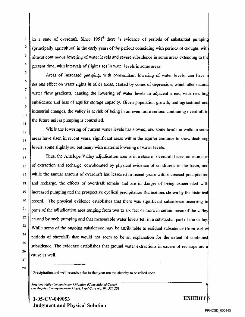
in a state of overdraft. Since 19514 there is evidence of periods of substantial pumpin
(principally agricultural in the early years of the period) coinciding with periods of drought, wi
almost continuous lowering of water levels and severe subsidence in some areas extending to th
present time, with intervals of slight rises in water levels in some areas.
Areas of increased pumping, with concomitant lowering of water levels, can have
serious effect on water rights in other areas, caused by cones of depression, which alter nature
water flow gradients, causing the lowering of water levels in adjacent areas, with resultin,
subsidence and loss of aquifer storage capacity. Given population growth, and agricultural an
industrial changes, the valley is at risk of being in an even more serious continuing overdraft i
the future unless pumping is controlled.
While the lowering of current water levels has slowed, and some levels in wells in som
areas have risen in recent years, significant areas within the aquifer continue to show declinin
levels, some slightly so, but many with material lowering of water levels.
Thus, the Antelope Valley adjudication area is in a state of overdraft based on estimate
of extraction and recharge, corroborated by physical evidence of conditions in the basin, an
while the annual amount of overdraft has lessened in recent years with increased precipitatio
and recharge, the effects of overdraft remain and are in danger of being exacerbated wit
increased pumping and the prospective cyclical precipitation fluctuations shown by the historica
record. The physical evidence establishes that there was significant subsidence occurring
parts of the adjudication area ranging from two to six feet or more in certain areas of the valle
caused by such pumping and that measurable water levels fell in a substantial part of the valley
While some of the ongoing subsidence may be attributable to residual subsidence (from earlie
periods of shortfall) that would not seem to be an explanation for the extent of continue
subsidence. The evidence establishes that ground water extractions in excess of recharge are
cause as well.
4 Precipitation and well records prior to that year are too sketchy to be relied upon.
Antelope Valley Groundwater Litigation (Consolidated Cases) Los Angeles County Superior Court, Lead Case No. BC 325 201
EXHIBIT 1-05-CV-049053 Judgment and Physical Solution
PPHCSD_000143

Safe Yield
A calculation of safe yield is necessary to manage the basin or create a physical solutio
to a potential or actual continuing overdraft. A determination of safe yield requires an initi
determination of average annual natural or native recharge to the aquifer from all sources. Th
only source of natural or native recharge for the Antelope Valley is precipitation that recharge
the aquifer and it is therefore necessary to ascertain average annual precipitation. Th
calculation of annual average precipitation can only be determined by using a baseline stud
period that covers precipitation in periods of drought and periods of abundant precipitation ove
a sufficient period of time that a reliable estimate of average future recharge based o
precipitation can be made.
It has been suggested that safe yield could be based on using shorter base periods or mor
than one base period, (the total time span of which was considerably less than the 50 year perio
the Court believes is more credible). If the purpose of selecting a base period is to determin
average recharge over time based on precipitation, choosing two consecutive periods of tim
with two different average numbers would not serve that purpose and would preclude estimatin
a single safe yield. Likewise, selecting a base period that does not have completely representativ
precipitation cycles over time would not provide an accurate evaluation of conditions in th
valley. A base period that calculates average precipitation over a representative period of tim
permits reliable predictions about future natural recharge based on regular recurring precipitatio
cycles. A period of precipitation fluctuations from 1951 to 2005 satisfies that standard. Shorte
periods do not.
The Court finds that current extraction of water from the aquifer by all pumping range
from 130,000 to 150,000 acre feet a year, but in any event, is in excess of average ann
recharge. The major area of dispute between the parties is the average amount of natura
recharge, which also involves disputes concerning return flows, the amount of native vegetatio
water needs, evapotranspiration, stream flow, runoff, groundwater infiltration, specific yield, la
Antelope Valley Groundwater Litigation (Consolidated Cases) Los Angeles County Superior Court, Lead Case No. BC 325 201
EXHIBIT 1-05-CV-049053 Judgment and Physical Solution
PPHCSD_000144

time, bedrock infiltration, agricultural crop needs, and the like. Other sources of recharge to the
basin, including artificial recharge-water pumped into the aquifer from external sources are no
in dispute.
Evidence established that during the entire historical period presented, population
increased within the valley and water use changed in a variety of ways. There has been a shift '
some areas to urban uses and away from agriculture although in recent years agricultur
pumping has also increased. The nature of agricultural duties has changed as well. The type o
irrigation used by farmers has become more efficient and less water is needed per acr.
(depending on the crops grown) with more efficient uses of water. But there has also been
increase as well as a change in the nature of the type of agriculture in the valley in materi
quantities in recent years. More of such changes may occur and it is important to both curren
and future generations to ensure that the water resources within the basin are managed prudently.
The Court heard from a very large number of experts, some of whom have provide•
opinion testimony of what constitutes safe yield. All the experts testifying acknowledged tha
changes in the selection of a base study period, lag time, agricultural water duties
evapotranspiration, specific yield, runoff quantities, well level contours, bedrock infiltration
return flows, playa evaporation relating to run off and bedrock infiltration, chlorid
measurements, satellite imaging, and agricultural and municipal pumping estimates, among
others, would affect the ultimate opinion of natural recharge and return flows.
The opinions of all the experts are estimates, based upon their professional opinion. All
of the opinions were critiqued by other experts who often had different opinions. The Court
recognizes the imprecision of the various estimates and the fact that an estimate by definition is
imprecise. But the fact that estimates lack precision does not mean that the Court cannot rely
upon such estimates. The scientific community relies upon such estimates in the field of
hydrogeology and the Court must do the same.
Reasonable experts can differ as to reasonable estimates of natural recharge and
virtually all other components of water budgets, computations of change of storage, and the
Antelope Valley Groundwater Litigation (Consolidated Cases) Los Angeles County Superior Court. Lead Case No. BC 325 201
EXHIBIT 1-05-CV-049053 Judgment and Physical Sol do
PPHCSD_000145

like, all the while using the same formulae and scientific principles to reach their conclusion.
For example, all the experts could agree on the definition of "Darcy's Law" and the physics
principle of "conservation of mass" but still reach different conclusions.
Some of the experts opined that the basin was not in overdraft and that recharge was
excess of or in balance with extractions so that there was a surplus in the aquifer. One expe
opined that loss of storage was merely space for temporary storage. Observable conditions in th
valley are inconsistent with those conclusions. If there were a surplus, even in the shortene
base periods used by the some experts, there should not be subsidence of land, nor the need t
drill for water at deeper and deeper levels in those parts of the aquifer most affected by th
overdraft. The physical condition of the valley is inconsistent with those estimates that there
and has been a surplus of water in the aquifer.
The selection of a safe yield number for an aquifer the size of the Antelope Valley
made difficult because of not only its size but because of the complexity of its geology. A
reflected above, hydro-connectivity and conductivity varies considerably between various part
of the aquifer. The hydro-connectivity between some portions of the adjudication area aquife
and others is so slight as to be almost (apparently) nonexistent. Pumping in those areas ma
have little or no effect on other areas of the aquifer. The Antelope Valley basin is not like
bathtub where lowering and raising of water levels is equal in all parts of the "tub."
Therefore, assigning a safe yield number (what quantity of pumping from the basin wil
maintain equilibrium in the aquifer) may require different numbers for different parts of th
aquifer (and clearly may also provide for some level of separate management). No attempt h
been made in this phase of trial to define geological differences in the valley that would justi
different safe yield numbers for different parts of the valley in light of the decision in Phase Twi
regarding connectivity (the Phase Two trial focused on hydro-connectivity for purposes o
determining necessary parties to the action).
Weighing the various opinions of the experts, however, the Court finds by
preponderance of the evidence that conservatively setting a safe yield at 110,000 acre feet a
Antelope Valley Groundwater Litigation (Consolidated Cases) Los Angeles County Superior Court, Lead Case No. BC 325 201
EXHIBIT 1-05-CV-049053 Judgment and Physical Solution
PPHCSD_000146

year will permit management of the valley in such a way as to preserve the rights of all parties
in accordance with the Constitution and laws of the State of California. Some portions of the
aquifer receive more recharge than others and pumping requirements vary. These differences
require management decisions that respect the differences in both the geology and the cultural
needs of the diverse parts of the valley.
It should not be assumed that the safe yield management number may not change as
climate circumstances and pumping may change, or as the empirical evidence based on
experience in managing the basin suggests it is either too high or too low.
!JUL 13 2011 Dated:
n. ack Komar Ju• ge of the Superior Court
Antelope Valley Groundwater Litigation (Consolidated Cases) Los Angeles County Superior Court, Lead Case No, BC 325 201
EXHIBIT 1-05-CV-049053 Judgment and Physical Solution
PPHCSD_000147

EX
HIB
IT 6
T 11 N
T 10 N
T 10 N
T 9 N
3 3 0
a: 4
;
a:
3 3
10
X CC
3 3 n ro X a:
T 11 N 36 31 36 36 31
36 31 30 31 31
r'""'"1.....,..................
36 31
1 8 1 6
31
1
36
6
31
1
36
6
31
1 6 1 6
36 31 36 31 58 31 36
1
38
6
31
1
36
6
31
1
36 31
6N
31 31
1
38
8
31
1
38
6
31
1 8 1 8 1 6 1 6 1 6 1 8
3 3 3 3
3 3
O 0 CI, 03
0 I,
CC CC
CC IX
CC CC
SCHEMATIC NOT TO SCALE; BAR CrAl F BELOW IS APPROXIMATE ONLY.
0 39 12 7 t-1 H
SCALE IN MILES
X 3
10
M
T 9 N
T 8 N
O
O z
t%
iA
tn p. O
C
COWS CF 101311ENS SOWN IMMO DAMICIe 1 E MMMON(' OF MC MONT
WS MOEIFS OSTRIM RE& =DM MASON If)
EDWARDS AIR FORCE BASE "• LOS INGQES. KOMI SAN 13171111101167 COMMIS. CA
BASE BOUNDARY (PERIMETER) DIAGRAM
T 10 N
T 10 N
T 9 N
T 9 N
T 8 N
9 JUNE 2000
DWG 273—M —PER
PPHCSD_000148

11 (15
Avenue M
„ r —
111—.7
I I ws L
Avenue N
17 '7 — - - -
4 —
LAWA Property
Lockheed Martin Property
LEGEND
Air Force Plant 42 Boundary Industrial Plant Boundary
RAIL LINE ROAD
SECURITY FENCE Elm BUILDING
Inset A
Avenue N
N .
Avenue P
GRAPHIC SCALE
r- 8—Ir" ' c=„- I Emergency Landing Area
I 11.
41\ PONNODI- PREPREO en
PRODUCTION PUGH T TEST INSTALLATION U.S.NN rax. PUNY 42
Air Force Plant 42 Installation Layout
sm. UNITED STATES AIR FORCE PLANT NO. 42 PREPARED PON, MRCS ruxrr. is
A A P ALM° ALE CALIFORNIA
1941 co 2011
APPROVED BY OPENAIIONS ANO TENANCE MANAGER
P4210242-101 ;miry and Rapp ...PR, 04 OPERATIONS MAINTENANCE AF 1.4—ANT 42 RAI—MC/ALE , CALIFORNIA REVISIONS REVISIONS
Emergency Landing Area 92 (See Inset A)
r"
li— g I
OL AFP 42 Site 5
8
rrlSite
PPHCSD_000149

Rights to Produce Imported Water Return Flows
A.V. MATERIALS, INC.
ANTELOPE VALLEY COUNTRY CLUB
ANTELOPE VALLEY EAST-KERN WATER AGENCY
ANTELOPE VALLEY WATER COMPANY
ANTELOPE VALLEY WATER STORAGE, LLC
BORON COMMUNITY SERVICES DISTRICT
CALIFORNIA DEPARTMENT OF PARKS
CALIFORNIA WATER SERVICE COMPANY
COPA DE ORO LAND COMPANY, A CALIFORNIA GENERAL PARTNERSHIP
CRYSTAL ORGANIC FARMS, LLC
DESERT LAKE COMMUNITY SERVICES DISTRICT
DIAMOND FARMING COMPANY
EDGEMONT ACRES MWC
EL DORADO MUTUAL WATER COMPANY
EYHERABIDE, RAY/EYHERABIDE SHEEP CO.
GEORGE LANE, AS TRUSTEE OF THE GEORGE AND CHARLENE LANE
FAMILY TRUST, DATED 12/19/2007
GOODE, FORREST G. 1998 TRUST
GRANITE CONSTRUCTION COMPANY
GREVIMWAY ENTERPRISES, INC.
H & N DEVELOPMENT CO. WEST
HARTER, SCOTT
LANDALE MUTUAL WATER CO.
LITTLEROCK CREEK IRRIGATION DISTRICT
LITTLEROCK SAND AND GRAVEL, INC.
LOS ANGELES COUNTY WATERWORKS DISTRICT NO. 40
PALMDALE WATER DISTRICT
PALM RANCH IRRIGATION DISTRICT
QUARTZ HILL WATER DISTRICT
ROSAMOND COMMUNITY SERVICES DISTRICT
1-05-CV-049053
Judgment and Physical Solution EXHIBIT 8 Page 1
PPHCSD_000150

SAINT ANDREW'S ABBEY, INC.
SHADOW ACRES MUTUAL WATER COMPANY.
SUNNYSIDE FARMS MUTUAL WATER COMPANY, INC.
TEJON RANCHCORP/TEJON RANCH CO.
U.S. BORAX & CHEMICAL CO.
WARNACK, A.C. AS TRUSTEE OF THE A.C. WARNACK TRUST
WEST SIDE PARK MUTUAL WATER CO.
WHITE FENCE FARMS MUTUAL WATER CO.
1-05-CV-049053
Judgment and Physical Solution EXHIBIT 8 Page 2
PPHCSD_000151

, -.7" ir ., r, ,
-• "''
, --- .1;-, 0.--r--
2 , , A
( /
, (^ .1
---N",,, -- (L" C — '
,;-1. 4 rid'j,
\ ,, _, 1 ' f,
(,,';',--/c- ,- —
_,. 12.,' '
\ " I 1 M UM/
, ,E s. •1A1, ,
_il
,1-1,: It_ -,,,,..... . a
. , .1
, 5_1, ;•--‘1 r._ .., IS
N 121M•\-dianyllir II iliiNtirAM
RalIff•NRALr 1""111i2=
,-. simummilir
- •
.----
- ,-'-'-z.z-i,-;,- --"-:,..•--,.__' ,\--,...
.,___Ii ,... imnrie_i),(/-,.--\ •.,0
- \ ?-2 1.,:i;', ,-, ,,,,.. rid
/- '7,....
:_q,./. ,,---;;;;. , 1.-;,- , \
r. )
) 1
fi...' M
\ ) 71
.- ., ,..-.- - a
c .... 1
, --
)',"• ' L •-2,411 '
0-4--
, , , r/ / L ' / ' MINSIMMIll ,,,k .., f •IMIIIIM. j", ' 'azse/,,z___ ''''' \ 1:3111-affla ri <"a. i ) ,/
\ MAthailli"
i (/';,'I C •••••M• •••Eifinal • • , , . , "-- ..--7.-.11,,- 1' "' I • aff•A•12 ••••••••••• •--eigiria 4...., .1( I:. ,,_ jip - v..-- • limmtorAmes. °, \\?--
1::1111:11411
mom -so 'MEM .. ' •Pifl - , ,, 0
\
‘s---7/. -----\(:-/ 2
• __, <
--9;7('-- 1,,-/ —,,,,
,,_f ,L, ,____ )-C-1 ••1 — / \ ,,N: ' ' \ \--- • ji , ,-,
?r,i,- . .. ae,— ,-- , < ',.,. .___..,,
1‘ , -:-7,:-'.:4
-1....„., , "7,_. ) / (ENE is - ;( v \ IIIIIIII ill palms \ , i , M1112,11•2211, INEMEE
r 11W2M•112 ■EM■ . • ----- -,,,,r
am d, : ---.,_. . , ------- . --, .7 / (,„i-/- - N'Ill•MOMMIIIEM. , ,,( 1-, .--r!` -6 N- \ 1.7/-c-_...),-, , ,
'A OREM • -• _ AN
7-c, ; 0,5,
-,,,,r L_ i , 111•Mr•••• ' .....--------,. 11WHikiiirtzwAN222110WIWR ;, NA,., ,,,p- -7 - lifieltilalliggiu1111 a... -
--....„ ‘,... _.,..,'= ..., '--•-, - ---i -̀r• \ ---' ---- \--... 7) 1 ..-1/(' rq
r k-N. r> \•\--- i.
_,____,- - wr, - --.__,-"- ---,:__---- E•111 WM
P.P.2511 Zel IN MIENHABEIMMEME
'"'51121N•126$11•120 I \ ::::-. .-N. -'----, (VitiMMIMINVAIMOMMil • IN \ ( ---, ELT=3artgorinii
c-- \ - marmoriumo.,..-- -- i, ,-. --,,,, -, (\ _ , IIIIII . _ -
„,„aistiokb WillAINIPMdfigertanii .11•M/222421Eitgaii i'INgl mg. - now
N / ,/ ..0 "
, ‘ ( a .
',,‘, )'?
le '\ \
,:i C
.,,,„ -
'- Air‘
,I10' W3PggaaODOM
niii
m-iai
alit
tis1
o
..-
.-
.A-4R1.,.
sk
.A
u-*il:
lc
tWbia
eilagRnrSg
geAM
iIL
,AgVu
rV
.I
-
mZ
,_'.st..vuM
siti
amIN
mik v
l' [Edwards AFB
*r -,..
• VIViirn- - .4 .srawneopeciirramsratiarioweir.mm 1 - i , .22 -_
/ 1 „, / , ,- 41 . m!"
r \ 2411 (
rc 112 I •
,.„' __.,421121151iMilMOM •2111•11052MigtAttAW! -- 111131MONAre41201211111211212121111•12, 1
.11. \ *--, 1 --.. N. \N 11211:Liar-ViZZAAINEMUMMIEMIEMIMM2id• ' 142 , \ "/ „,
--'11i()
___--- pi...claannunemuvr-nuas—
alICICIIPIlleitIVICHICIIIIIIIILIIVralrilliMairl-"- - ........7* --lc \ - icattassiga Iv"
41
1120-NPAREOMINIEW101iLmo111201211rETMTAM 4415rilL11111•100•10•1211111201111mminniuMME -?..---0"AiiiitigingaNNEMOUDOCliiiSENUMEN c=i
mum®
.7-auciunpar- v t s c
7 V_,Iii, "(1_11. 1114111-.- • _II I tJ'''''7 '
' ' r
• li m .. AI g.rmib.
(
, ite"4 !ft 6 a
xi- Ill
/ ( illio.._-_-2 r r,7001M106.;,.-n--11 Dim-
; S' arlieNNLICMICOWSID"
, 6raligho--•-•• -slew
r IVXIMMOD, EMU.
FAPc-11E
111113•1112•1111•1 MOM mamma magnatingammaganam.
Onnonnumunisnuommisemaannamach.:40. UM- . ''.* ,/
- ''' ---- • IL /7 / it 1 ri 21614 aina 1 4-cram. - i7k im '74/114P iii • MIMS
• ---. - .
•
• Ai 1-
L __
-,„ • lio 0 .._ -rasomannammumamill91111311111111111111111111191
.11•••••••••••••••••••••••••EpRid.r• 10-112421 IPL1 ...-,. V• --c--,- Efh •,,, nounsamemormiuminctummomminii MILIEVAM, IBA c no
afil .lik! --1.- ..z74..4., .__ ii. -49 _1312•012111EDMMEMEIMMO•11•01201:121•1201 'MAE ' '-' - 'r macmancianconnumaa13111111XCIEMERIL 'Zieggint.. " Antelope Valley Adjudication Area
' -A,Miliii1111112.71/110C10101:91111101:111111111111:11311313111102011100.11MIN01611 9J.c... MN •
Proposed Adjudication Boundary --:-..'''-',..,4111011011121111112211;75:z( ‘11•110•11•111•1112221••1122WitikitA I ^ow' ff. sl. \ \, \
\
\ _
?
Vii MIliii1110111111641_- ilIllCMIIIIIIIIICMMIIMIIIIIICIIIIIIEELW5.11 = - --'- -,,,:l.- 9-'-
k"--Kil'Iki.1213111401 11.111111111111111MMInnarintlitaIriti la t 1,„,,•.... k..
—Aqueducts I Dept of Defense li-Zr.IIMMOrwill•MIIIUMIE MOMONWIMME2211111 , I 3, , E "'- -- 9 '41",•.--,,,. INN, N1 LisalttEi.1\(' - " 1, , 1/
Perennial Streams I I Bureau of Land Management ini ' b "-1114:glaktsm1u' - 1 -K (r Ikt, it - - - Seasonal Streams L 1 U.S. Forest Service i // IIILlnskl.g§.13 ' ' 1" ' '11 C ii, ::/2)
i l ̀;
A, /1wi
/ ''''''
Fautls 67..1 Other Federal • EAFB Production Wells MN State-County-Municipal . Gauging Stations I I Private
NOTE. -.........,.... — Antelope Valley Groundwater Basin Boundary
/ .
/ : , '
i ° I( i i ;
. 46, . - -/ ,---.., ' i✓ /c-----
\ --
..,-.4.-.-
10,21M1016:,,,",
\ 1 L .......
Boundary Of The Antelope Valley Watershed Contributory
" irm=311197111311141141111511/11/11Lal,
igkIklarlaillintalriallgiall IOU gator= m...atirenn
l' .•,. -"IikefElEMER
t
, c r
)
/ i
/i) 4/ /1 ( i ) ) , "
' r ') ' ,5--,-11.-1-12! rile° 'WI i , \)
1411117''Ill ..:" To The Antelope Valley Groundwater Basin I/ ,
„ j.„....„:„:', ' ' 1; r,,I ' I 011:24..M3
--444KINNikidligla I' '
' ' ' 411 , ,, OPP4110
il MEI
,...._ _.,
50 10 15 20 25 Miles
-Z--- - •-•-_,_,--
"tir
t --. 1
--: h.'5 ''
- -billb...
9 i ( ? ( i ' , ,, ,,
ilergerla a,
Apikt• i f
,
—11141rIkr—d -
LE , 4
, . S 4
I-05-CV-049053
Judgment and Physical Solution
EXHIBIT 9 PPHCSD_000152

Edwards AFB
a
SOUTHEAST (a AIANAGEMENT ARE1
Patti tft,11P
EXHIBIT 10
SUBAREAS
WILLOW SPRINbs 'AIANAGEMENT ARE
WEST IANAGEMENT AREA ee Rosamond
—1--i
•
z
• (*EN-TRU IAINAGEMENT AREA
aster
LEGEND
ArrtE,ope %Vey water Compaq.
MI Boron Cenumellt) Denims DtstrIcl
MI Los AngaleE Coirity rarer wins DIsinct 4C
111111 =erect Creek !motor DIealct
PaArn narIVN arqaCon :ADAM
Palm:L.1e Water CSWZS
Ow= rill water Deana
Rosana-IC Community DeritCeS District
Miltry
OAsiscknanal Sr:unix)
1-05-CV-049053 Judgment and Physical Solution
PPHCSD_000153