i-7-4 2 0 1 1 · pdf file2 0 1 1 towards putrajaya ... putrajaya to embark on innovative...
TRANSCRIPT

1
2 0 1 1
TOWARDS PUTRAJAYA GREEN CITY 2025 IMPLEMENTING NEIGHBOURHOOD WALKABILITY IN PUTRAJAYA
Planning Strategy for Sustainability
Sabeen Qureshi1 and Ho Chin Siong2
ABSTRACT:
Putrajaya is a Malaysia’s new federal Government Administrative Centre. The Putrajaya was planned to embrace two major themes: i.e. A city- in- a- garden and an intelligent city. Putrajaya was intended as an independent city employing federal government employees and those in service industry positions to serve them . Sustainability concept is clearly evident in the designation of almost 40% of its total city area of 4,931 hectares specifically for green and open spaces in the Putrajaya Master plan. The hot and humid climate is one of the biggest challenges to urban designers in Malaysia, as daytime temperature rise above 30°C (86–90 F) throughout the year . One of Putrajaya’s main shortcomings is that the climatic response in landscape architecture is minimal. With great design freedom, an expansive budget and an explicit goal of creating a ‘garden city’, the designers for Putrajaya have missed an important opportunity to advance microclimatic design as it can be seen in walkways as they are mostly not covered nor they are shaded by trees so the pedestrians are expose to direct sunlight . The target for “Low- carbon Putrajaya” is reducing GHG emissions intensity by 50% compared to year 2005 level. This target is an extension of Malaysian national target, 40 % reduction of emission intensity by 2020. One of the Goal of Putrajaya Green City 2025 is to make walking as preferred transport option (Walkable city). To achieve this goal we used Neighborhood Environment walkability Scale (NEWS) to compare how people perceive or think about their neighborhood that is differed on measures derived from Geographic information system databases. This study will be based on empirical study of selected precinct by carrying out questionnaire survey and documented survey by filling out questionnaire and observation survey. The purpose of this research is to examine people’s perception towards walkability as a mode of transportation. The results show residents of high walkable neighborhood reported higher residential density, land use mix, street connectivity, infrastructure and safety from walking then lower walkable neighborhood.
Keywords: Walkability, Neighborhood, Landscape Architecture, low carbon society, Garden City. 1
1 Ph.d Research Student in Faculty of Built Environment Universiti Teknologi Malaysia (UTM) Skudai Johor . [email protected]
2 Professor in Faculty of Built Environment Universiti Teknologi Malaysia (UTM) Skudai Johor / Deputy Director International Affairs, Chancellery Universiti Teknologi Malaysia (UTM) Skudai Johor. [email protected]
- 409 -
I-7-4

2
1. INTRODUCTION
In May 2007, Japanese Government has identified building Low-Carbon Society and promoting Innovative Technology Development as two keys to make global emission half in 2050. Ministry of the Environment, Japan has started to develop ideas on Low-Carbon Society’s principles, images and strategies to realize, mainly for Japan. This work, was not based on numerical scenarios, instead, this tried to describe broad direction toward Low-Carbon Society. Images and strategies for Low-Carbon Society should be diverse among countries, depending on their natural environment, developing stages, industrial structures. But they believe that elements Japan describes will be useful for other countries and they would like to work together for further development of ideas with international colleagues.
Principles for a low-carbon society:
All the world’s countries need to unite to make supreme efforts to establish a low-carbon society by “reducing global emissions by half from the current level by 2050.” For example, if CO2 emissions per capita were the same worldwide when the 50% reduction is realized, the developed countries would need to reduce its per capita emissions by 70 to 80 %from the current level, and the developing countries would need to keep approximately the current level while achieving economic growth and improved quality of life. Such a society cannot be realized if the current trends continue. All countries, organizations, and entities have to take action based on the following philosophies.
1. Carbon minimization in all sectors: “A low carbon society” in the ultimate sense would be a society that emits greenhouse gases only in an amount which can be absorbed by nature (Carbon Neutral Society). To achieve this goal, we have to have a social system that all sectors, such as industries, governments, and citizens, will naturally or automatically give special consideration to their selection and decisions in order to minimize carbon-dioxide emissions (carbon minimization).
2. Towards a simpler life style that realize richer quality of life:
People would need to forgo the mass-consumption society, mainly formed by developed countries, and build a new society in which value is placed on family or community ties, health, interactions with mother nature and “Mottainai” spirit to improve the quality of life. This type of consumer choice would lead to a revolution in the social system, moving toward a low-carbon, rich society.
3. Coexistence with nature:
We recognize human and its society is a part of global ecosystem. In order to secure the CO2 absorption essential for a low-carbon society and to adapt to the unavoidable global warming, it is important to maintain and restore rich, diverse natural environments, such as forests. To achieve this symbiosis, local communities should place importance on harmony and coexistence with nature, and promote “nature-friendly technologies,” such as utilization of biomass. [1]
- 410 -
3
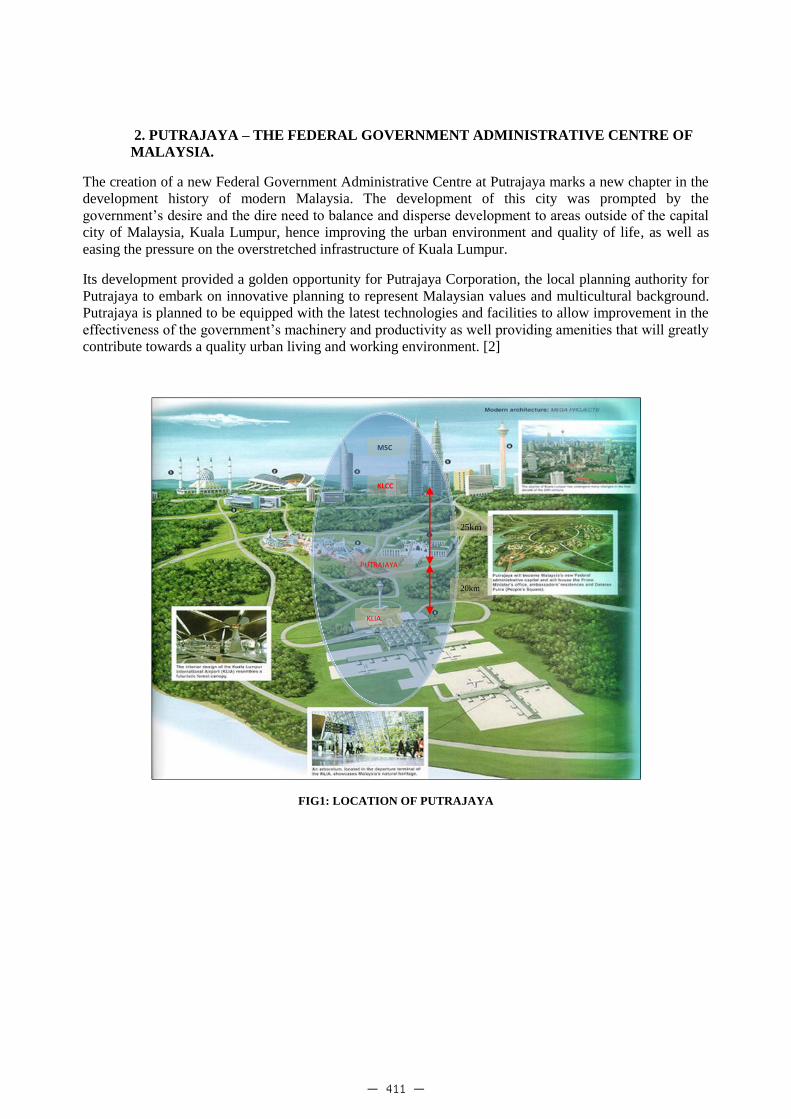
2. PUTRAJAYA – THE FEDERAL GOVERNMENT ADMINISTRATIVE CENTRE OF MALAYSIA.
The creation of a new Federal Government Administrative Centre at Putrajaya marks a new chapter in the development history of modern Malaysia. The development of this city was prompted by the government’s desire and the dire need to balance and disperse development to areas outside of the capital city of Malaysia, Kuala Lumpur, hence improving the urban environment and quality of life, as well as easing the pressure on the overstretched infrastructure of Kuala Lumpur.
Its development provided a golden opportunity for Putrajaya Corporation, the local planning authority for Putrajaya to embark on innovative planning to represent Malaysian values and multicultural background. Putrajaya is planned to be equipped with the latest technologies and facilities to allow improvement in the effectiveness of the government’s machinery and productivity as well providing amenities that will greatly contribute towards a quality urban living and working environment. [2]
FIG1: LOCATION OF PUTRAJAYA
MSC
KLCC
PUTRAJAYA
KLIA
25km
20km
- 411 -

4
3. PERRY’S NEIGHBORHOOD PLANNING CONCEPT AND PHILOSOPHY:
The tendency of city planners to translate general aspirations into concrete community designs is clearly evident in Clarence Perry’s contribution to neighborhood planning. Perry’s Neighborhood Unit Plan was an attempt to adapt the social uniformity sought by the settlement house workers into a blueprint for the automobile age (Perry 1924). His scheme included a residential space for a given number of families, recreation space, local schools, commercial shops, and the separation of vehicular and pedestrian traffic. By the late 1940s, Perry’s neighborhood unit had become one of the most widely discussed urban planning ideas (Stein 1945; Dahir 1947). Clarence Perry defines the neighborhood as a component of a town and defines its size based upon a five-minute walking radius. The radius is measured from the center, and the center holds the cultural uses such as a school. A five-minute walking distance is approximately 160 acres. Clarence Stein expanded the definition of neighborhood center in 1942 by connecting the neighborhoods together to create towns. In the 1920’s and 1940’s, the centers and anchors of neighborhoods were the schools. More recently, the quarter-mile walking radius has been expanded to a half mile with the addition of a transit hub. Traditional neighborhood size works well in the town, village, and urban city scales. [3]
FIG.2: CLARENCE PERRY’S “NEIGHBORHOOD UNIT” OF 1929
- 412 -

5
4. NEIGHBORHOOD CONCEPT IN PUTRAJAYA:
All residential areas within Putrajaya are developed on the ‘neighborhood’ concept. At the heart of this concept is that each distinct neighborhood within a larger residential precinct will be well-serviced, would have good access and vehicular and pedestrian movement routes, have ample facilities, or be well connected to such facilities, have adequate landscaped open spaces, be safe and secure, be well- maintained and equally important, have a critical mass of residents to make it livable, regardless of housing density. Each neighborhood would be define by road ways, parks and open space or housing blocks. At the minimum, each neighborhood would have atleast one neighborhood park and would be in close proximity to a larger park beyond its boundary. [4]
Fig3: Nighbourhood Planning
5 Minute walk quarter mile
Neighbour hood Edge
Neighbourhood Centre Precinct creating communal space
5 Minute walk quarter mile
Neighbour hood Edge
Neighbourhood Centre Precinct creating communal space
- 413 -

6
Putrajaya is a plan driven city based on two underlying concepts, the city in the garden and the intelligent city. The adoption of these concepts to guide its physical development was aimed at a balanced and sustainable development, environmentally socially, as well as economically. Sustainability concept is clearly evident in the designation of almost 40% of its total city area of 4,931 hectares specifically for green and open spaces in the Putrajaya Master Plan.
In brief, the distinguishing features of the master plan are as follows:
� Planned population is about 347,000 people.
� A large proportion of the city area is designated as green open space,
� A large water body (600 hectares) of man-made lakes and wet lands was formed by utilizing the small rivers which run through the area;
� The lake created a 38 kilometers long water front area;
� Open spaces are developed according to a complete hierarchy, including 12 metropolitan parks;
� A 4.2 km long boulevard forms the central spine of the city.
TABLE 1: LAND USE COMPONENTS
Land use Hectares Percentage[%] Note (i)Largest Man- made wet lands in the tropic. (ii) Largest Man-made lake in the tropics covering an area of 400 hectares. (iii) Highest percentage of open spaces and recreation areas among all categories/neighborhood
Government 225 4.6%
Residential 711 14.4%
Commercial 139 2.8%
Mixed use 41 0.8%
Special Use 138 2.8%
Service industry 11 0.2%
Public Amenity 344 7.0%
Open space 1930 39.2%
Infrastructure & Utility 483 9.8%
Road 908 18.4%
Total 4931 100%
Sources: Putrajaya Structure Plan- Report of Survey 2009 ( in Malaysian language )
At the Copenhagen COP15, Malaysia made a conditional commitment of a reduction of carbon emission intensity of Malaysian GDP, of up to 40% by 2020 from a 2005 baseline and this is followed by the Prime Minister announcement in the 2010 Malaysian Budget speech, that the government will “develop Putrajaya and Cyberjaya as Pioneer Township in Green technology as a showcase for the development of other townships.” Rising up to the challenge, Putrajaya Corporation in collaboration with the ministry of Energy, Green Technology and Water and the Sepang Municipal council, have taken a bold step forward to formulate a Green City Action Plan for Putrajaya and Cyberjaya. To start with, Putrajaya Corporation has taken the initiative to conduct a carbon emission baseline study for Putrajaya. Putrajaya Corporation and other relevant organizations have formed a research team to prepare the feasibility study towards Putrajaya green city 2025. The Goals for PGC2025 in terms of quantitative environmental targets are
- 414 -

7
outlined in three themes. The three themes are “Low carbon Putrajaya” for climate change mitigation, “3 R Putrajaya” for recycle-based society and “Cooler Putrajaya” for mitigating urban heat environment. Towards achieving a Green City in Putrajaya, twelve actions are introduced. These actions are divided according to the three environmental targets. The detailed action names and the amount of Co2 emission reduction each action contribute can be seen in table 2.
Table 2:CO2 EMISSION REDUCTION AMOUNT
Action no.
Name of actions GHG emission reduction [Ktco2eq]
Contribution in total reduction [%]
1 Integrated City Planning & Management
306 13.8%
2 Low-carbon transpotation 574 25.9%
3 Cutting-edge Sustainable buildings
673 30.4%
4 Low carbon Lifestyle 71 3.2%
5 More and More renewable energy
50 2.3%
6 The Green lung of Putrajaya 35 1.6%
7 Cooler urban structures and buildings
63
2.9% 8 Community and Individual action to reduce Urban temprature
9 Use less consume less 8 0.4%
10 Think Before you throw 332 15.0%
11 Integrated Waste Treatment 100 4.5%
12* Green Incentives and Capacity Building
- -
Total of PGC2025 Actions 2,213 100%
Others** 398 -
Total 2,611 -
*Actions 12 do not have its emission reduction.
** It includes contribution from freight transport (2.7%) and central power generation (13.5%)
*** Action 1 leads to walkable city
Action 1 Integrated City Planning & management primarily focus on Modal shift from motorized to non-motorized movement and Enhance Mixed-use & Diversified Development by emphasis on neighborhood planning concept; where self-contained residential areas are placed near workplaces. Residents can live and work within short distance to minimize crowded and time-consuming commuting trips from home to work. The sustainable planning concept will help shorten the passenger transport lengths and vehicle mile travel (VMT), and in some cases help to further promote cycling and walking trips. [5]
- 415 -

8
FIG4: GHG EMISSION REDUCTION BY ACTIONS
Table 3: Sub-actions & programs in Action 1 related to Walkable City
- 416 -

9
5. ISSUES AND CHALLENGES OF WALKABILITY IN PUTRAJAYA:
In Putrajaya despite of borrowing concept from New Urbanism’s emphasis on dense building and walkability Putrajaya is still relatively low density and it is a long, hot walk to get anywhere and there are no shade trees provided for pedestrians movement .There is no continuity of the people activity from the public transportation with the pedestrian way to reach their destination. Most of the places in Putrajaya do not attract people to walk. It does not support the policy to reduce the Automobile dependent because of most of the people still use the private vehicle to reach their destination. On the other hand the local government has not planned the pedestrian environment to encourage active life style in the major areas. One of the main shortcomings in Putrajaya’s planning is Putrajaya’s wide formal avenues expose pedestrians, building and traffic to direct sun light. Bicycles are used only as recreation rather than as a mode of Transportation as is made clear by the lack of contiguous bicycle trails on key routes throughout the city. The lack of shade also discourages green forms of transportation such as walking and cycling.[6]
6. METHODS
6.1 Procedures
Potential participants were selected from one high walkable neighborhood precinct 9 and other one low walkable neighborhood precinct 8 chosen. The two areas were chosen having a different income group Precinct 9 has house hold monthly income ranging from 3000RM-6000RM and Precinct 8 having a house hold monthly income ranging from 6000 and above. And a similar median resident age (high walkable 20-30years and low walkable 35-45 years). The high walkable area Precinct 9 is near to the Putrajaya Sentral transportation hub, generally flat with many intersections. Precinct 9 has a high population density with a mixture of dwelling style comprising of apartments, small living units, multiple storey complexes. It is one of the bigger precincts in Putrajaya. It is planned as a medium-high to high density residential area to optimize its location adjacent to the main ERL/LRT station in precinct 7 and its proximity to major routes. Along the primary access road within the precinct are located all the public facilities. The main character of the precinct is defined by the high-rise high density residential blocks. There are many community facilities such as Health Centre, a School complex, a post office, a Mosque, a Surau, a Public Market, a Community Hall, and a bus depot, open spaces are in form of linear Park, Neighborhood parks, and other landscaped reserves.
The low-walkable area Precinct 8 is located at the western boundary of Putrajaya. It is one of the mid- sized precincts in Putrajaya. Due to its water front location, Residential area in this precinct is maintained as medium density. There are many community facilities such as School complex, two post offices, a police station, a mosque, a Surau, a Branch library, a public market, a Multi-purpose community hall, an information Centre and a Putrajaya Service Centre.
Initially A modified Version of the NEWS (Saelens et al..2003a) was used to asses neighborhood environment characteristics with known relationship to walking behavior. The original survey was developed for use in the USA and also included items on bicycle use. Some minor wording changes were required and some items related specifically to bicycling were deleted. Environment characteristic assessed in the survey included: residential density; proximity to and ease of access to non- residential land uses such as restaurants and retail stores ( land-use mix diversity and land use mix access); street connectivity; walking facilities (e.g., footpaths, walking paths); aesthetics; traffic safety; and safety from crime.
- 417 -

10
6.2 Data Analysis
Data were entered and checked using SPSS version 19. The reliability of each variable was assessed. And also mean and standard deviation were computed. Table 3 shows the detail of it.
Table 3:Test-retest reliability (intra-class correlation) and means (standard deviation) sub scale score for Precinct 9 (high-walkable and low-walkable neighbor hoods)
Neighborhood Environment
Characteristic (No. items)
Test- retest reliability
(N=71)
High-walkable (Precinct 9)
Residents (N=50) mean (SD)
Low-walkable (Precinct 8)
Residents(N=50),mean(SD)
Residential Density (6) .78a 2.23 (.83) 1.92(.64)
Land-use mix diversity (23) .84 3.15(.98) 2.84(.68)
Land-use mix access (7) .85 3.18(.46) 2.70(.83)
Connectivity (5) .69 3.08(.23) 2.60(.65)
Infrastructure for walking (6) .87 2.1(.79) 1.9(.66)
Aesthetics (6) .78b 1.92(.64) 2.23(.83)
Traffic Safety (6) .75 4.03(.30) 3.10(.28)
Safety from crime (6) .95 3.00(.92) 2.35(.85) a High walkable > low walkable
b low walkable > high walkable
CONCLUSION:
This study examined the test-retest reliability and construct validity of the items of the Neighborhood Environmental Walkability Scale in Malaysian context. In past this survey instrument gauging perceived attributes of the neighborhood environment has been used in USA, Australia and Hong Kong. Test-retest reliability of the News was observed in the USA (ICC: 0.58-0.80) in Australia it was observed (ICC: 0.62-0.88) and Test-retest reliability of the Chinese NEWS-A was found to be good, with ICC ranging from 0.57 to 0.99(means ICC: 0.87), which were higher than those observed in USA. In tropical climate of Malaysia it was observed ICC ranging from 0.69 to 0.95 as shown in table 3 so this result concludes that NEWS can be used by Urban Planner, Urban Designer or land scape Architect as a core standard instrument for measuring perceived characteristics of the built environment in international research. This research concludes that making walking as preferred transport option will reduce 2.4% CO2. It is interesting to note in Table 3 that low walkable neighborhood precinct 8 residents had higher ratings of Aesthetics due to attractive landscape architecture views there and there are many attractive buildings and homes there. In order to implement walkability in Putrajaya it was essential to identify the main barrier in walkability first. With the help of NEWS we also identify those barriers. This research also concludes that there were statistically significant differences in resident’s ratings of environmental characteristics for walking as a transport between those living in high and low walkable areas for density, land use mix, street connectivity and infrastructure for walking; this shows that residents from neighborhoods with different characteristic do perceive these attributes differently.
- 418 -

11
Fig5: PUTRAJAYA MASTER PLAN
- 419 -

12
Fig6: PUTRAJAYA PRECINCT 8 AND 9 NEIGHBOURHOODS
Precinct 8 plan Precinct 9 plan
REFRENCES:
1. Building a low carbon society First Draft Ministry of the Environment, Japan December. 2007.
2. Creating the essence of cities: the planning & development of malaysia’s new federal administrative capital, Putrajaya info.worldbank.org/etools/docs/library/235915/s5_p22paper.pdf referred on 30/5/2011
3. Sustainable Neighborhood planning for the Region Neighborhood scale http://www.tcrpc.org/orientation/2009%20Orientation%20Series/Council%20Series%2010-16-09%20Neighborhoods,%20Disticts,%20and%20Corridors%20(Center%20and%20Edge).pdf Referred on 30/5/2011
4. Putrajaya Review master plan 1997 page 6-15
5. Putrajaya Green City 2025 Base line and preliminary study March, 2011 pages 3-7
6. Moser Sarah. (2009) “Putrajaya: Malaysia’s new federal administrative capital” Cities volume27issue 4, August 2010pages285-297.
- 420 -