hydromorphological pressures in the koiva...
TRANSCRIPT

CASE STUDY REPORT on Gauja/Koiva River to test and
demonstrate the elaborated significance criteria
„ HYDROMORPHOLOGICAL PRESSURES IN THE
KOIVA RIVER BASIN DISTRICT AND THEIR
IMPACT”
2013
Project „Towards joint management of the transboundary Gauja/Koiva river
basin district” (Nr. EU 38839)

Project „Towards joint management of the transboundary Gauja/Koiva river basin district” (Nr. EU 38839) 2
Author
Arvo Järvet, PhD (geography)
NGO Development Centre of Livonia
CASE STUDY REPORT
„HYDROMORPHOLOGICAL PRESSURES IN THE KOIVA RIVER BASIN DISTRICT AND THEIR IMPACT”
The report prepared in the frame of the Estonia – Latvia programme 2007-2013 project „Towards joint management of the transboundary Gauja/Koiva river basin district” (Nr. EU 38839)
Tartu 2013

Project „Towards joint management of the transboundary Gauja/Koiva river basin district” (Nr. EU 38839) 3
Table of contents
Introduction ......................................................................................................................................................................................... 4
1. CLASSIFICATION OF WATERCOURSES ............................................................................................................................ 6
2. AN OVERVIEW OF HYDROMORPHOLOGICAL ASSESSMENTS OF WATERCOURSES IN OTHER
COUNTRIES .......................................................................................................................................................................................... 8
2.1 Overview of methods used in other countries.................................................................................................... 15
2.2. Standard “EVS-EN 15843:2010 Water quality – Guidance standard on determining the degree
of modification of river hydromorphology” ..................................................................................................................... 17
3. HYDROMORPHOLOGICAL ASSESSMENT OF WATER BODIES ........................................................................... 19
3.1 Formation of hydromorphological status ............................................................................................................. 19
3.2. Selecting hydromorphological indicators ............................................................................................................ 20
3.2.1. Indicators characterising water catchment area .................................................................................... 21
3.2.2. Characteristics of rivers ....................................................................................................................................... 22
3.2.3. Riverbed parameters ............................................................................................................................................. 23
3.2.4. Floodplain and banks ............................................................................................................................................. 25
3.2.5. Hydrological regime ............................................................................................................................................... 26
3.3. Sinuosity as an integral morphological feature ................................................................................................ 27
3.3.1. Determination of the sinuosity factor ........................................................................................................... 28
3.3.2. Classification of rivers according to the sinuosity factor .................................................................... 30
3.4. Hydromorphological pressures ................................................................................................................................ 31
4. ESTONIAN WATERCOURSES IN THE KOIVA RIVER BASIN DISTRICT .......................................................... 38
4.1. Division of Estonian and Latvian transboundary water bodies and their catchment areas ..... 38
4.2. Hydromorphological pressures in the Koiva river basin district and the hydromorphological
assessment of watercourses ................................................................................................................................................ 40
4.3. Assessment of the hydromorphological status of watercourses in the Koiva river basin
district ............................................................................................................................................................................................. 42
4.4 Assessment of the hydromorphological status of watercourses in the Koiva river basin district
according to the standard “EVS-EN 15843:2010 Water quality – Guidance standard on
determining the degree of modification of river hydromorphology” ............................................................ 46
5. OVERVIEW OF DATA SOURCES FOR THE ASSESSMENT AND IMPROVEMENT OF THE
HYDROMORPHOLOGICAL STATUS OF WATERCOURSES ......................................................................................... 49
CONCLUSIONS .................................................................................................................. Error! Bookmark not defined.
References .......................................................................................................................................................................................... 53

Project „Towards joint management of the transboundary Gauja/Koiva river basin district” (Nr. EU 38839) 4
Introduction
The ecological status of water bodies is determined by biological, physical-chemical and
hydromorphological quality indicators. Besides biological quality indicators, hydrological,
morphological and physical-chemical indicators are also considered to determine the ecological
status of a water body in order to assess whether, and to what extent, human activity has affected
the natural regime of the water body through those elements. Human activity has altered and is
altering the natural status of rivers by dredging, straightening, impounding, etc.
The Koiva river basin district management plan covers the Estonian side of the Koiva (Gauja)
river and its river basin district. The Republic of Latvia has also prepared a Gauja river basin
district management plan (LVGUBA) for the Latvian side of the river basin district. The first
river basin district management plans were prepared separately and no transboundary
management plan has been developed. In that regard, the report on the Gauja/Koiva river basin
submitted to WISE (Water Information System for Europe) gives different time schedules and
lack of added value due to limited resources as reasons. Only a small part of the river basin
district is located in Estonia and human impact on the area is marginal. Estonian-Latvian
cooperation in the field of water management is based on several agreements and a joint
Gauja/Koiva river basin district management plan is being prepared, which is scheduled for
completion by the end of 2015. The objective of this paper is to develop practical methods for
the morphological assessment of Estonian rivers, by taking into account the objectives laid down
in the EU Water Framework Directive. To date, the assessment of hydromorphological indicators
of watercourses has been rather limited. Therefore, the use of these indicators to determine the
status of water bodies has been based on different principles. There are almost no substantive
assessments based on the hydromorphological indicators because most assessments have been
prepared on the basis of aquatic biota. If hydromorphological assessment criteria were applied,
the result would probably be somewhat different.
The status of surface water bodies is assessed by taking into account the natural features of the
water bodies. Each water body is assigned a natural type. The type of water body is determined
by a set of natural features of the water body or a part of it that distinguish the watercourse or

Project „Towards joint management of the transboundary Gauja/Koiva river basin district” (Nr. EU 38839) 5
standing body of water or a part of it from the rest of the water body or its parts or from other
water bodies. Due to the humid climate and articulated landform, the network of watercourses in
Estonia and Latvia is relatively tight. The majority of the rivers are small: short, narrow and
relatively shallow (not very deep). The width of river valleys varies between 100 metres and 1-2
kilometres. The valleys of the Koiva and Mustjõgi rivers are much wider than the valleys of
other rivers in the Koiva river basin district in Estonia. The gradient of rivers varies greatly due
to the natural formation of the relief forms. Different methods have been suggested for assessing
the hydromorphological status of watercourses but very few specific measures have been
implemented in practical water management. This expert opinion draws on the findings of
studies conducted in other EU member states; the choice of assessment criteria is largely based
on the recommendations of the standard “EVS-EN 15843:2010 Water quality – Guidance
standard on determining the degree of modification of river hydromorphology”. This paper
concludes with an overview of the division of transboundary water bodies and their catchment
areas between Estonia and Latvia, an assessment of hydromorphological status by water bodies
and an overview of the main information sources for the hydromorphological assessment of
watercourses.

Project „Towards joint management of the transboundary Gauja/Koiva river basin district” (Nr. EU 38839) 6
1. CLASSIFICATION OF WATERCOURSES For the purposes of water management plans, surface water bodies are divided into natural, heavily modified and artificial water bodies. Heavily modified water bodies (HMWB) and artificial water bodies (AWB) are designated based on various guidelines and the agreed methodology. For the final designation, all water bodies initially designated as heavily modified or artificial were divided into three groups based on the cause of modification or artificial nature of the water body:
a) impounding
b) land reclamation
c) infrastructure
Water use and types of physical alteration used to designate water bodies as heavily modified or artificial are specified in water management plans in accordance with Article 4(3) of the Water Framework Directive. However, in the case of watercourses with a small river basin the designation of a water body as heavily modified or artificial requires the specification of artificial recipients created for the purpose of land reclamation. Many artificial and dredged water bodies are registered in the Environmental Register as streams and rivers and, therefore, they were designated as natural water bodies due to the lack of clear criteria and methods for calculating the morphological parameters. In the course of further specification, the share of water bodies classified as natural water bodies with a river basin under 100 km2 is likely to decrease significantly. The water management plans admit that the assessment of the quality of water in water bodies may be inaccurate due to the lack of necessary information (in the first stage of preparing the plans). According to Paragraph 2.3 of the water management plan, the following additional information was used to designate heavily modified and artificial water bodies:
1. A study conducted for the purpose of the final designation of heavily modified surface water bodies and artificial water bodies;
2. A list of artificial recipients of drainage water maintained by the state;
3. The register of land reclamation systems.
Surface water bodies are discrete sections or parts of water bodies, which differ from each other by their specific natural characteristics, the nature of the impact of human activity, or any other significant and distinguishable parameters. In the course of establishing and designating surface water bodies, all water bodies were divided into sections and parts based on agreed features and criteria. In order to establish and designate surface water bodies, all running watercourses with a catchment area more than 10 km2 and all standing bodies of water (lakes) with the area of more than 50 ha are taken into account. Surface water bodies were established on the basis of the natural types of water bodies, distinguished from each other mainly by their hydrochemical qualities and morphological features. The types of water bodies are described according to system B provided in Annex II to the Water Framework Directive. Each surface water body was assigned a natural type. Seven different types of watercourse in the case of rivers and eight

Project „Towards joint management of the transboundary Gauja/Koiva river basin district” (Nr. EU 38839) 7
different types of standing body of water in the case of lakes were used to establish the types of surface water bodies. The establishment of the types was based on the following criteria:
• Natural differences between water bodies, e.g. flow rates in rivers;
• Human-induced pollution load and its extent;
• Human impact on the physical condition of the water body;
• Stricter protection requirements established for protected areas. Water bodies were classified according to System B in Annex II to the EU Water Framework Directive, according to which the following factors are obligatory:
1) altitude – not relevant in the Baltic ecological region because all watercourses are located on the lowlands, i.e. below 200 m above sea level.
2) The geographical location (latitude and longitude) is easily determined and shown on digital maps; there is no need to distinguish this feature because the coordinates of the locations form a part of the GIS-based system.
3) The geological conditions of the river basin are taken into account through the chemical qualities of water (the content of organic matter based on by chemical oxygen demand (permanganate).
4) The size of a river basin district is a hydrographical characteristic on the basis of which watercourses are distinguished; four main types of watercourse can be distinguished in the Baltic countries (Table 1).
Therefore, the status class of Estonian natural watercourses is determined on the basis of the following two main characteristics:
a) The morphological characteristic (the size of a river basin);
b) The physical-chemical characteristic (the content of organic matter based on chemical oxygen demand).
Table 1. Types of natural water body in Estonia.
Type Description Found in the Koiva river basin district
IA dark-coloured, humic substance-rich (CODMn 90% value above 25 mgO/l) rivers with a river basin of 10–100 km2
8
IB light-coloured rivers with a low content of organic matter (CODMn 90% value below 25 mgO/l) and a river basin of 10–100 km2
2
IIA dark-coloured, humic substance-rich (CODMn 90% value above 25 mgO/l) rivers with a river basin of >100–1000 km2
No

Project „Towards joint management of the transboundary Gauja/Koiva river basin district” (Nr. EU 38839) 8
IIB light-coloured rivers with a low content of organic matter (CODMn 90% value below 25 mgO/l) and a river basin of >100–1000 km2
7
IIIA dark-coloured, humic substance-rich (CODMn 90% value above 25 mgO/l) rivers with a river basin of >1000–10,000 km2
No
IIIB light-coloured rivers with a low content of organic matter (CODMn 90% value below 25 mgO/l) and a river basin of >1000–10,000 km2
1 (Koiva river)
IVB rivers with a river basin area of more than 10,000 km2 (the Narva river)
No
As regards the optional factors, meteorological indicators (air temperature range, mean air temperature and precipitation) are not relevant in Estonia. Due to the small territory, the differences are marginal within Estonia and do not have any effect on the establishment of different types of water bodies. The chemical factors not relevant in Estonia are: the acid neutralising capacity and chloride content; the physical factor not relevant is the transport of suspended solids. The hydrographical indicator ‘distance from river source’ is used to define rivers by sections. The river discharge (flow) category is a factor characterising the discharge regime and using that factor would be justified. However, to use this factor, hydrological distribution of Estonia is required. Valley shape is a general geographical feature that has not been used in determining river types.
2. AN OVERVIEW OF HYDROMORPHOLOGICAL ASSESSMENTS OF
WATERCOURSES IN OTHER COUNTRIES As regards choosing a method for the assessment of the hydromorphological condition of water bodies, it is appropriate to give a short overview of the surveys conducted in other EU member states. We have selected six countries: Austria, Denmark, France, Germany, the United Kingdom and Slovakia. Austria
The assessment of the physical status of rivers started in Austria in the 1980s. Very few nationwide coordination activities have been carried out. Two methods are used to determine the hydromorphological quality of water. The first method has been used in Upper Austria since 1980s and the other has been used nationwide. The second method has been used to assess larger rivers with a wide floodplain. River sections are defined based on geological conditions, gradient, morphological parameters and human impact. The main factors used were physiographical and hydrological parameters together with a biological component – fish fauna. The indicators are determined for the total length of the river. Information is obtained from maps

Project „Towards joint management of the transboundary Gauja/Koiva river basin district” (Nr. EU 38839) 9
(geology, topography, valley’s morphology, stream order, bioregion, discharge regime (including minimum discharge). Reference material concerning the natural status of rivers is available since the beginning of the 19th century for the following parameters: characteristics of floodplains (alluvian water bodies) and riverbanks, land use type, characteristics of riverbeds (gradient, width, rapids, sediment bars, bank erosion, macrophytes).
The information is mainly presented in the form of description and morphological and structural parameters are compared with those of natural rivers of the same type. Old maps, some even from the mid-18th century and early 19th century, are used to find reference data. In such cases, the quality of habitats is assessed by comparing it with the habitats determined on the basis of old maps.
Additional data are collected through fieldwork in order to have more material for comparison with historical data. Good habitats are those river sections where the riverbed has not undergone systematic changes and hydropower has not been used in large scale. Any changes in these sections are related to the land use on floodplains; therefore, there are few natural floodplains left. Other water bodies (river sections) are designated as moderately or heavily modified water bodies and no further classification has been applied. The data are consolidated on the basis of GIS. Denmark
The Danish Stream Health Index (DSHI) was developed to allow a habitat component of river quality to be used in environmental impact assessment, setting targets in catchment plans and reporting on the state of the environment. The index consists of two separate sets of parameters:
• Catchment land use and geological conditions.
• Site-specific parameters.
The index is found on the basis of 20 parameters. The method was developed for small wadeable streams in lowland areas. The assessments of the hydromorphological features were carried out in two stages. 1) an overview of the catchment area and 2) site characteristics. The findings are illustrated by graphs, photos and drawings. It takes about an hour to complete a questionnaire for one site during fieldwork. The main parameters are entered into a GIS-based database. The index value is calculated on the basis of all registered parameter intensities and the weight of each parameter. Each parameter has four possible scores and two values of importance, 1 or 2. The final index value is the sum of all individual scores. Five habitat quality classes are used. France
The French Ministry of the Environment and environmental agencies have developed a parameter (SEQ physique) to determine the physical quality of rivers; the parameter is found on the basis of three components. This consolidated parameter provides the required information on the processes occurring in rivers, on habitats and on the potential use of water. It has been used for planning water management and establishing the priorities for river conservation and restoration activities both in river basin districts and regionally. The method was designed for assessing both natural and artificial changes and is used in the implementation of river

Project „Towards joint management of the transboundary Gauja/Koiva river basin district” (Nr. EU 38839) 10
restoration projects. The index has been used to distinguish French river types by hydrological regions.
The consolidated parameter is found (calculated) by comparing actual indicators with reference conditions and is based on the typology of watercourses. The typology was developed by taking into account the use of hydropower, existence of floodplain, geological conditions, hydrological regime and other indicators. Different types of rivers differ significantly by the processes occurring in these rivers and their physical indicators. For example, the lack of floodplain is not relevant in the case of mountain rivers but is important in the case of rivers flowing through plains. Flow characteristics have different weights. River sections with different features are determined by using maps, taking into account gradient, geology, variability of floodplain, impact of larger tributaries, etc. The length of river sections may vary from a couple of hundred metres to a few kilometres. Currently, such a method for determining river sections is used only for some rivers. Two types of descriptive indicators are used:
1) structural characteristics describing the morphology of the riverbed;
2) functional hydrological characteristics.
It should be borne in mind that morphological features can be used to characterise hydrological processes. Morphological features are mainly taken from the descriptions of rivers and hydrological characteristics from the existing databases. The collected data are linked with GIS and digital maps. The indicators, broken down by the physical features of the floodplain, hydrology, banks and riverbed and other indicators, are assigned numerical values ranging from 1 to 100. The scale of 1 to 100 is divided into five equal parts, called classes, which are used to prepare maps and tables. Germany
The German system of the hydromorphological assessment of rivers was developed by the German Working Group on Water Issues (LAWA) and the German Institute of Hydrology. Each state has its own hydromorphological system based on the federal standard. The German system was designed differently for small, medium-sized and large rivers in order to more effectively take into account the hydromorphological features arising from the size of the river.
Hydromorphological parameters are compared with reference locations and the so-called deficit of hydromorphological structure, i.e. how much worse than the condition of the reference water body is the condition of the location at issue, is identified. Different methods are recommended depending on the level of detail and objectives of hydromorphological assessment:
1. A detailed overview of hydromorphological parameters that facilitate planning and are identified as a result of fieldwork.
2. A general overview at the regional, state and federal level, prepared under relevant programmes and used in strategic planning.
The materials of detailed overviews can be used for strategic purposes to avoid duplication. Detailed overviews serve as a basis for planning works on rivers. Aerial photographs, maps and survey plans at a scale of up to 1: 2,500 are used. More than 20 parameters describing the

Project „Towards joint management of the transboundary Gauja/Koiva river basin district” (Nr. EU 38839) 11
riverbed, riverbanks and floodplain are determined. The general assessment is based on average values. Two different methods are used depending on the size of the river:
1) for small and medium-sized watercourses:
• visible bottom;
• width of riverbed <10 m;
• length of section 100 m;
2) for medium-sized and large rivers, including navigable rivers:
• bottom not visible;
• width of riverbed >l0 m;
• length of section 1 km. A consolidated assessment of hydromorphological quality is a combination of two groups of parameters – the characteristics of the riverbed and floodplain. The hydromorphological typology of German rivers has not been completely established yet. Each parameter is compared with that of a natural reference water body and assigned scores from 1 to 7 depending on the level of naturalness. These are indicated on the map by different colours. The river sections that are artificial due to navigation, flood reducing structures, settlements (cities) they flow through or the use of hydropower are indicated separately. Besides generalised maps (based on summarised parameters), maps drawn on the basis of a single parameter are also used in ecological assessment of rivers. United Kingdom
Similarly to Denmark, hydromorphological assessment in the UK aims at assessing the physical character of wadeable1 streams and it was developed to help the conservation and restoration of the rivers of the UK and their floodplains. The system was developed to allow a habitat component of river quality to be used in environmental impact assessment, setting targets in catchment plans and reporting on the state of the environment. The system can be used to anticipate the requirements of the Water Framework Directive. There are now more than 12,000 sites on the national UK database. The standard field sample unit is a site on a 500 m length of watercourse. Measurements are done and information is collected from 10 spot-check transects 50 m apart, while flow types and habitat features are determined for the whole site. Habitat features and artificial modifications in the river channel together with land-use in the river corridor (50 m on either side) are recorded. Data on geology, gradient and height are added. The basis for quality assessment is relative. Features recorded from a site are compared with the database inventory of baseline survey sites in the UK. The baseline survey comprises 5,600 sites sampled in stratified random fashion from rivers and streams classified for water quality
1 In the course of preparing this expert assessment we struggled with translating the term ‘wadeable river’ used in literature to describe the morphological condition of rivers. It was decided to use direct translation into Estonian – kahlatav jõgi. This is a river through which anglers and researchers wearing waders and wetsuit can wade. It seems that the term kahlatav jõgi in Estonian language is suitable.

Project „Towards joint management of the transboundary Gauja/Koiva river basin district” (Nr. EU 38839) 12
purposes. A consolidated assessment is presented as an assessment of the habitat quality and changes, whereas the changes related to human activity are decisive. The results are presented in numeric values. Slovakia
The method developed in Slovakia is based on the work carried out in other countries, in particular in Germany, on larger rivers. Assessment is based on a) fieldwork materials and b) maps and databases. Fieldwork is carried out during periods of low flow. The maps used are topographic maps with a scale of 1: 10,000, aerial photographs and historic maps, geological maps with a scale of 1:50,000 and other available materials. The length of the surveyed sections depends on the width of the river and the following parameters are used to identify river types:
� small rivers – section width <10 m, section length 200 m;
� medium-sized rivers – section width 10–30 m, section length 500 m;
� large rivers – section width >30 m, section length 1000 m.
In all cases, the surveyed sections are divided into five parts of equal length and a survey profile is prepared for each sub-section. Each bank and the floodplain are also described. Sinuosity is assessed for reaches that are longer than the surveyed sections. The results are presented by sections and sub-sections and each parameter characterising a section is calculated as the arithmetic mean or a sum of subsections, depending on the nature of the parameter. The final score is a number between 1 and 5 where 5 corresponds to a natural river and 1 is the equivalent of a completely modified river section.
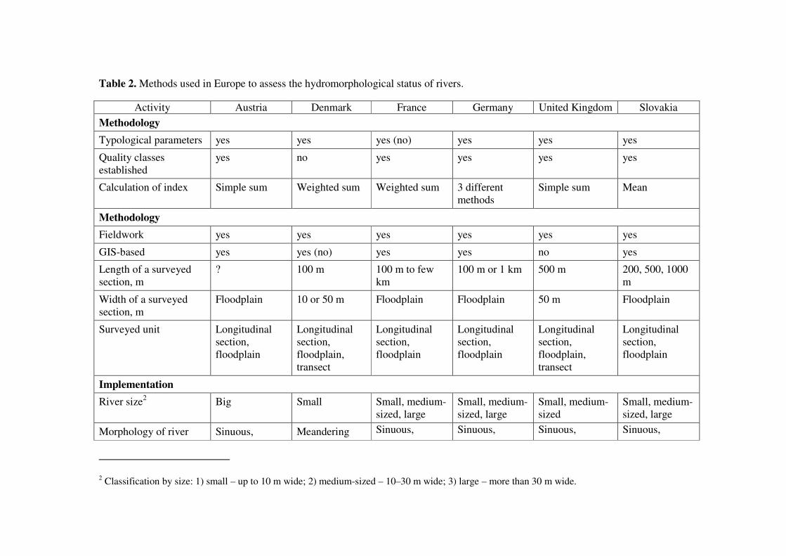
Table 2. Methods used in Europe to assess the hydromorphological status of rivers.
Activity Austria Denmark France Germany United Kingdom Slovakia
Methodology
Typological parameters yes yes yes (no) yes yes yes
Quality classes established
yes no yes yes yes yes
Calculation of index Simple sum Weighted sum Weighted sum 3 different methods
Simple sum Mean
Methodology
Fieldwork yes yes yes yes yes yes
GIS-based yes yes (no) yes yes no yes
Length of a surveyed section, m
? 100 m 100 m to few km
100 m or 1 km 500 m 200, 500, 1000 m
Width of a surveyed section, m
Floodplain 10 or 50 m Floodplain Floodplain 50 m Floodplain
Surveyed unit Longitudinal section, floodplain
Longitudinal section, floodplain, transect
Longitudinal section, floodplain
Longitudinal section, floodplain
Longitudinal section, floodplain, transect
Longitudinal section, floodplain
Implementation
River size2 Big Small Small, medium-sized, large
Small, medium-sized, large
Small, medium-sized
Small, medium-sized, large
Morphology of river Sinuous, Meandering Sinuous, Sinuous, Sinuous, Sinuous,
2 Classification by size: 1) small – up to 10 m wide; 2) medium-sized – 10–30 m wide; 3) large – more than 30 m wide.

Project „Towards joint management of the transboundary Gauja/Koiva river basin district” (Nr. EU 38839) 14
branching branching branching branching branching
Number of parameters 34 20 50 25 200 29
Catchment area
parameters
Land use yes yes no no no yes
Geology yes yes yes yes no yes
Size yes yes yes yes yes yes
Floodplain parameters
Vegetation cover yes yes yes yes yes yes
Structure yes no yes yes yes yes
Land use no no yes yes yes yes
Connectivity yes no yes yes yes yes
Bank parameters and
vegetation cover
no no yes yes yes yes
Riverbed parameters
Substrate yes yes yes yes yes yes
Vegetation yes yes yes no yes no
Erosion/accumulation no no no yes yes yes
Riverbed geometry yes yes yes yes yes yes
Flow features yes yes yes yes yes yes
Fragmentation yes no yes yes yes yes
Hydrological regime
Qmax yes no yes no no yes (no)
Qmin yes no yes no no yes (no)

Project „Towards joint management of the transboundary Gauja/Koiva river basin district” (Nr. EU 38839) 15
2.1 Overview of methods used in other countries
1) Use of reference conditions and typology
The assessment is based on the physical parameters of watercourses and the methodology reflects their typological differences. The existing databases are used and some parameters are collected in the field. The determination of reference conditions is somewhat ambiguous. It is better to determine reference conditions by countries, rather than for Europe as a whole. 2) Determination of different types of river
The typology of rivers is inevitably based on the specific conditions of a country or a region for which the typology is developed. The typology is the narrowest in Denmark where only wadeable lowland streams with small or medium sinuosity are assessed. In Germany, two different systems are used to assess small and medium-sized streams and large rivers. The assessment method used in the UK is applied to both upland and lowland streams but only those that are wadeable. The systems developed in France and Austria are applied to both upland and lowland streams as well as to watercourses of all sizes. However, the assessment method depends on the morphology of a river and it is not clear how that method can be used for all types of rivers. 3) Length and width of a surveyed section
The length of a surveyed river section is fixed in the Danish and UK assessment systems, whereas the methods are designed primarily for wadeable rivers and focus mainly on the riverbed. Floodplain as an important hydromorphological feature is also surveyed. The length of a surveyed section is at least 100 m in the case of small rivers and usually longer than 1 km in the case of large rivers. Therefore, the length of a surveyed section depends directly on the size of the river. In Slovakia, for example, surveyed sections are divided into shorter parts in order to interpret the parameters of the riverbed and morphology of the river. In Denmark, the description of the floodplain is limited to land use within the first 10 m of the riverbed (up to 50 m for larger rivers). Land use data and geomorphological data are recorded during fieldwork but not used in hydromorphological assessment. 4) Assessment
The UK and Danish methods are based on the data collected on sites in the course of fieldwork. Other methods require the use of maps, GIS layers or aerial photographs to assess the hydromorphological features; GIS-based typology is used in all assessment systems. Similarities exist between the different assessment systems and the parameters used, but there are also significant differences between the systems when it comes to assessing the parameters on site. The UK system is based on natural features and non-natural features are not taken into account. The values of all parameters are taken into account in the final assessment. According to the Danish method, all parameters are assessed based on their intensity. A four-point assessment scale is used and the parameters are assigned numeric values based on their importance. The index value is the sum of the values of individual parameters. The German and Slovakian systems are based on the same principles as the UK and Danish systems although they are more complex. According to the German method, parameters are assigned points between 1 and 7 and according to the Slovakian method, between 1 and 5. In the German system, a parameter may be

Project „Towards joint management of the transboundary Gauja/Koiva river basin district” (Nr. EU 38839) 16
assigned a different value depending on the type of the river; this means that natural differences in the morphology and size of the river are taken into account. The French system is also based on the difference in the importance of parameters. For example, the assessment of upland rivers differs from that of lowland rivers. This allows to reduce the weight of those parameters that are not important in certain types of rivers and to increase their weight in the case of other types of streams. This assessment method can be used to assess very different types of rivers. 5) Number of parameters
The number of parameters differs from country to country. The Danish system uses 20 parameters, only one of which is measured on site (river width). The UK system, on the other hand, uses 200 different parameters. The French and Austrian systems use hydrological parameters that describe the hydrological regime of the river and are based on discharge measurement data. The method designed for larger rivers also uses the information available on maps. 6) Floodplain assessment
Floodplains are assessed in the case of large rivers. This means that a riverine habitat covers both the riverbed and the surrounding landscape in the river valley. The biological value of a river depends on connectivity between the riverbed and the river valley. The assessment of floodplain comprises the assessments of the vegetation structure and the artificial structures on the floodplain. In many cases, information required for assessing floodplains, especially large areas, is obtained from maps. The data concerning floodplains are supplementary and are not used for the physical assessment of rivers. 7) Assessment of riverbanks
Bank features are best recorded in the field and the collected data is used to describe natural erosion and accumulation patterns in the riverbed. In addition, the data on vegetation structure on banks and in the buffer zone are recorded. It is important to record information on artificial elements that have been used to reinforce the banks. 8) River shape
According to the German, Austrian and Slovakian methods, information about previously natural watercourses that have been directed into artificial channels is used to assess the changes. Old maps are used to obtain the required reference information. The Danish system does not use reference data concerning the shape but determines the sinuosity of rivers and the occurrence of rapids and pools with slow flow velocity. 9) Riverbed shape
The shape of the riverbed is assessed based on its cross-section. According to the Danish method, there are four cross-section types, ranging from natural to heavily modified. Such assessment is related to the depth parameter, which is the main parameter to assess changes in the cross-section of the riverbed. The variation of the width is not relevant although the Danish method measures the width of the river section in 10 cross-sections. The UK and German methods record the morphological features of the riverbed and the degree of variation subjectively.

Project „Towards joint management of the transboundary Gauja/Koiva river basin district” (Nr. EU 38839) 17
10) Longitudinal connectivity
Changing structures of the riverbed that affect the flow regime and the movement of flora and fauna along the river are recorded in most cases. The assessment of these elements depends on the magnitude of their effect and they are assigned negative values. In some cases, several parameters that influence the quality of flow are distinguished. These parameters are usually damming structures, diversion of water and impoundment. 11) Hydrological regime
Austria and France use directly measurable parameters that indicate the hydrological regime. These countries use the data of long-term hydrological monitoring that characterise the rivers of the region at issue. Germany and Slovakia use the parameters of hydrological variability determined in the course of fieldwork and the information received from landowners. Slovakia also collects hydrological data to determine the amount of impounded water. The UK uses indirect assessment to identify floodplain-related changes in the hydrological regime. Denmark does not assess hydrological pressure; although changes in the buffer zone are recorded, they are not used in the final assessment.
2.2. Standard “EVS-EN 15843:2010 Water quality – Guidance standard on
determining the degree of modification of river hydromorphology”
The standard was developed by a group of experts and it is recommended for the hydromorphological assessment of watercourses. The standard has been transposed by 21 EU member states, including the Baltic countries. The standard provides guidance on the hydromorphological assessment of rivers by sections. According to the standard, mainly qualitative features are used but quantitative features are also taken into account if possible. The standard uses ten features that are divided into two groups: 1) core features and 2) subsidiary features. The use of features such as geographical location, altitude, geological conditions and the size of the river mean that most rivers can be compared based on the standard. The core features are used to establish hydromorphological modifications, including the assessment of pressure factors. Subsidiary features are mainly used to assess the quality of habitats (Table 3). Table 3. Standard “EVS-EN 15843:2010 Water quality – Guidance standard on determining the degree of modification of river hydromorphology”
Parameter Core feature
Subsidiary feature
Explanation in the context of the Koiva river basin district
1. CHANNEL GEOMETRY
1a) Planform + Assessed on the basis of the sinuosity factor

Project „Towards joint management of the transboundary Gauja/Koiva river basin district” (Nr. EU 38839) 18
1b) Long-section and cross-section + What is important is the long-section; the differences in the cross-section are not considered because this requires an extensive special study
2. SUBSTRATES
2a) Artificial material + In the Koiva river basin, the main impact is that of land reclamation
2b) Natural material + In the future, joining features 2a and 2b should be considered
3. CHANNEL VEGETATION AND ORGANIC DEBRIS
3a) Aquatic vegetation management + Not considered in the Koiva river basin district
3b) Woody debris and floating debris
+ An important parameter in rivers with a smaller catchment area (less than 300–400 km2)
4. EROSION/DEPOSITION CHARACTER
+ The intensity of the process can be assessed and distinguished by using the long-section
5. FLOW
5a) Artificial in-channel structures + Impounding dams, culverts
5b) Effects of catchment-wide modifications on natural flow character
+ No effects in the Koiva river basin district
5c) Effects of daily flow alteration + Hydropeaking
6. LONGITUDINAL CONTINUITY AS AFFECTED BY ARTIFICIAL STRUCTURES
+ Not present in the Koiva river basin district; single cases occurring elsewhere are accounted for under 5a
7. BANK STRUCTURE + The composition of the bank material is taken into account
8. VEGETATION TYPE/STRUCTURE ON BANKS AND ADJACENT LAND
+ Assessment of the area within the 10 m riparian zone through adjacent land-use
9. ADJACENT LAND-USE + Assessment of the area further than 10 m from the banks on the basis of maps

Project „Towards joint management of the transboundary Gauja/Koiva river basin district” (Nr. EU 38839) 19
10. CHANNEL-FLOODPLAIN INTERACTIONS
10a) Degree of lateral connectivity of river and floodplain
+ In the Koiva river basin district, interactions exist in places where the channel is not artificial
10b) Degree of lateral movement of river channel
+ It is taken into account that in sections that flow in an artificial channel the channel processes are not natural
3. HYDROMORPHOLOGICAL ASSESSMENT OF WATER BODIES
3.1 Formation of hydromorphological status
Various methods laid down in the EU Water Framework Directive are used in the classification of the status of water bodies. One of the most widely used method is the comparison of water bodies with natural water bodies and those affected by human activity, i.e. with reference water bodies. While in the countries with high population density and intensive economic activity reference water bodies are hard to find, there are plenty of such rivers and streams in Estonia and Latvia. The situation is opposite in regard to rivers and streams with a very small catchment area (less than 100 km2) or small headwaters of larger rivers. In Western Europe, for example, small water bodies are mainly found in low-density areas, including middle and high mountain areas. In the Baltic countries, however, such water bodies have been heavily modified, mainly due to land reclamation. The majority of such small water bodies in Estonia and Latvia are either artificial watercourses or heavily modified water bodies. For this reason, the hydromorphological assessment of the Gauja/Koiva river basin district must be based on local circumstances and it is not possible to use exactly the same methodology that has been used in other countries. It is likely that from the perspective of the determination of the river type-specific fish communities it is irrelevant as to whether the river/stream concerned is fed from a limestone or sandstone outcrop catchment area. Also, there are no fish species in Estonia who would prefer either harder or softer water. What is important for fish is the physical quality of their habitat, in particular the nature of substrate. The biota of watercourses and the functioning of the ecosystem depend mainly on two groups of factors:
A) Natural factors that determine the reference conditions:
1. Size (discharge).
2. Gradient (flow velocity).
3. Bottom structure.
4. Temperature regime.

Project „Towards joint management of the transboundary Gauja/Koiva river basin district” (Nr. EU 38839) 20
5. Connectivity with other water bodies.
B) Human induced factors that modify natural conditions and the impact of which need to be assessed:
1. Changes in the physical quality of a watercourse as a habitat.
2. Changes in the natural hydrological regime.
3. Changes in the quality of water.
4. Fragmentation of the watercourse.
The definition “Hydromorphological features of a water body” includes the features that characterise the river channel, its banks and the floodplain. The hydromorphological characteristics of a watercourse are not normally associated with those features. Therefore, a wide-spread methodological approach is used to distinguish between the morphological status and hydrological regime of water bodies. Combining these characteristics requires taking into account the specifics of the hydraulics of rivers, which depends on the channel shape and flow regime. Very complex systems can be developed for the classification of hydromorphological elements but in real life such systems need to be simple, understandable and easily implemented by environmental and other agencies. Somehow, hydromorphological elements are only considered important when water bodies of a very good ecological status are assessed. They should also be taken into account when assessing water bodies of a lower status class because watercourses that are more or less similar by their physical-chemical and biological qualities may differ significantly in terms of their value as a habitat due to their hydromorphological differences. However, when classifying water bodies of a good quality their hydromorphological features must be such that they support the biological conditions of the good ecological status. This means that achieving good hydromorphological quality indicators, such as flow regime, nature of river channel, sinuosity, etc. is a precondition for biological diversity. The aim of hydromorphological status assessment is two-fold:
a) to identify the differences between watercourses and between different sections of a watercourse;
b) to analyse the characteristics that are likely to have a direct impact on the ecological status of a water body.
3.2. Selecting hydromorphological indicators
The hydromorphological elements on which the assessment of the status of rivers is based must be easily measurable so that they could be determined using map information, without systematic additional measuring and monitoring. In Estonia and Latvia, watercourses are classified according to System B laid down in Annex II of the EU water framework directive. According to that system, the compulsory features include altitude, which is not relevant in the Baltic ecological region because all watercourses are located on the lowlands, i.e. below 200 m above sea level. The geographical location (latitude and longitude) is determined cartographically and is easily fixed on digital maps; there is no need to distinguish this feature separately. The

Project „Towards joint management of the transboundary Gauja/Koiva river basin district” (Nr. EU 38839) 21
geological conditions of the river basin are taken into account through chemical qualities of water (the content of organic matter based on oxidation by permanganate) and the types of watercourse are determined based directly on the size of the catchment area. The features used in assessing the morphological status of watercourses are grouped as follows:
1. Characteristics of the catchment area (size (area), geological conditions, land use).
2. Characteristics of the river (gradient, sinuosity, connectivity with other water bodies, fragmentation).
3. Characteristics of the channel (channel parameters, erosion and accumulation processes, bottom materials (sediments), vegetation).
4. Bank structure (morphology, vegetation).
5. Existence of floodplain and its characteristics (width, land use, structure).
6. Hydrological regime (smallest and biggest runoff, temperature regime).
The most important characteristics of the river are gradient and channel shape and material. Gradient also characterises the energy of flow, which on its own is not a very informative feature. The shape of the river channel is characterised by its width, depth and sinuosity. Sinuosity is an integral feature that is characterised by the sinuosity factor. The variable “Channel material” that characterises the nature of the channel depends directly on the gradient and is important for aquatic biota. It should be taken into account that the characteristics of river channel, such as width and depth, are more important in the case of small and medium-sized watercourses (Types IA, IB, IIA, IIB) and less relevant in the case of larger rivers (Types IIIA, IIIB and IVB). Integral features “gradient” and “sinuosity factor” can be used in the comparison and classification of watercourses. Channel characteristics “width”, “depth” and “channel material” are important for characterising the specific sections of the river.
3.2.1. Indicators characterising water catchment area
As regards aquatic biota, the main indicator of the size of a watercourse is river discharge. The latter is well characterised by the size of the catchment area. Although these two features are relatively well connected, there are still exceptions. Some sections of watercourses with a smaller catchment area are actually richer in water during low water periods than watercourses which have a significantly larger catchment area. Naturally, this is reflected in the condition of the biota. The river sections that are intensively fed from ground water, in particular those that originate from larger springs or springy lakes, have significantly bigger runoff during the periods of minimum water. The EU water framework directive, however, prefers to characterise the size of a water body by the size of its catchment area. This is probably so for the sake of rationality because the size of the catchment area is easier to determine and calculate than the run-off characteristics. The size of the catchment area is known for all water bodies. For larger water bodies (with a catchment area of more than 25 km2) the sizes of their subcatchments are also calculated.

Project „Towards joint management of the transboundary Gauja/Koiva river basin district” (Nr. EU 38839) 22
3.2.2. Characteristics of rivers
The characteristics of rivers can be used in planning water management in order to conduct a comparative assessment of all water bodies. The majority of the information about rivers is available on maps although the data on altitude need to be specified in order to determine the varying gradients of small rivers and streams. Gradient
For aquatic biota, gradient is one of the most important hydromorphological impact factors besides river discharge. Gradient is the feature on the basis of which it is easiest to divide a river hydromorphologically into rhithral and potamal reaches. There is, however, a small problem – the gradient of small rivers and streams changes rapidly along the river. Therefore, the data on the gradient of reaches is somewhat generalised. It is considered practical (Järvekülg, 2003) that in small rivers and streams (with a catchment area of <100 km2) gradient is determined for sections of approximately 1 km (about 0.5 km upstream and downstream from the centre of a monitored section), in medium-sized rivers (with a catchment area of 100–1000 km2) for sections of approximately can 5 km, and in larger rivers (with a catchment area of >1000 km2) for sections of approximately 10 km. In order to describe the specific habitat conditions of aquatic biota, gradient should also be determined for the whole monitored section. The water level data necessary for determining the gradient are available on topographic maps. The most suitable maps are Soviet-time maps at a scale of 1:10,000. The data on the water levels of watercourses should be gathered and stored in a single database. The currently used fisheries monitoring data form divides monitored reaches into five sub-types taking into account the channel material.
1) rapid;
2) rhithral;
3) sand-bottom;
4) potamal hard-bottom;
5) potamal soft-bottom;
In Estonia we should add the sixth subtype, “peaty”, which is found mainly in artificial channels, in particular in the regions of large drained bog woodlands.
Sinuosity
Sinuosity is considered to be a good indicator of the ecological status of watercourses because it quite clearly characterises the diversity of the biotopes suitable for the biota, including fish. Sinuosity can be determined on large-scale maps. In the Baltic ecological region, the most suitable scale is from 1:10,000 to 1:20,000. Old maps can be used to determine the sinuosity of rivers before modification, i.e. their natural sinuosity before dredging and straightening. Sinuosity is discussed in more detail in the structural part of this paper, taking into account that it is a good integral characteristic that is quite easily determined.

Project „Towards joint management of the transboundary Gauja/Koiva river basin district” (Nr. EU 38839) 23
Connectivity with other water bodies
What is important from the perspective of aquatic biota is the recipient of a watercourse, and the source in the case of rivers starting from a lake. Coastal rivers, for example, which are also spawning sites for highly migratory species of fish, and rivers that flow into and start from Lake Peipsi and Lake Võrtsjärve tend to be richer in fish resources in terms of both species and quantity. These rivers, in particular those flowing into the Baltic Sea, are more important for fisheries than other watercourses. Despite the fact that the fish in such rivers (reaches of river) are heavily influenced by lakes, the connectivity between such water bodies should be considered very important for aquatic biota. For example, the lower reaches of rivers flowing into Lake Võrtsjärv with small gradient and slow flow are important spawning places for various species of fish. While the flow regime indicators (flow velocity in particular) are the main factors used in the typology of watercourses, connectivity with other water bodies is not even included in the optional factors. However, this factor is important considering the density of Estonian watercourses and their hydrographical connectivity. When assessing the connectivity between watercourses, fragmentation has the opposite impact to the above-mentioned. Rivers are mainly fragmented by dams and occasionally by culverts that prevent fish from swimming upstream. Dams prevent fish from moving upstream to their spawning places and habitats. The construction of dams reduces the number of rapid reaches because rapids upstream from the dam (if there were any) are flooded. The factor that can be analysed is the share of impounded reaches (length of impounded reaches/length of the reach concerned) upstream from the dam.
3.2.3. Riverbed parameters
Gradient, flow velocity and the naturalness of the river bottom are very important factors for aquatic biota. Gradient is critical, because flow velocity depends on gradient and the formation of riverbed sediments depend on flow velocity. Flow velocity also depends on the river discharge – the bigger the discharge the higher the flow velocity. The easiest way to account the riverbed parameters is to divide reaches into rhithral and potamal, according to the typology of watercourses. In order to keep the typology simple, these factors should be considered together because, as a rule, there is a clear correlation between them. Rhithral reaches have more rapids and fast-flowing reaches and, therefore, coarser substrate (rocks or gravel) and less fine sediments (sand, mud, clay, peat) than in potamal reaches. The biota of rhithral and potamal reaches, including fish communities, differ significantly from each other even within the same river. The flow affects the river biota directly by exerting mechanical pressure and indirectly by determining the living conditions, especially the gas regime (O2 content depends largely on the flow velocity) and the type of sediments. In fast-flowing rivers, the oxygen content of water is high, i.e. 70–90 % of the natural saturation degree, all year round. Due to their mainly rocky bottom, fast-flowing rivers are excellent habitats for macro algae, mosses and invertebrates that need solid substrate for anchoring themselves to the bottom. Because of the specifics of the living conditions, fast-flowing rivers and reaches are inhabited by

Project „Towards joint management of the transboundary Gauja/Koiva river basin district” (Nr. EU 38839) 24
rheophilic fauna and flora, i.e. species that prefer fast-flowing water. On a rocky bottom, fauna is richer in slow-flowing reaches than in fast-flowing reaches. Only a few species of fish (freshwater trout, grayling, common minnow) who are strong swimmers and some benthic species (bullhead, stone loach) can live in very fast-flowing reaches, usually in the upper reaches. From the point of view of fish fauna researchers, a practical typology of rivers based on gradient, flow velocity and substrate nature would be the following:
a) rihithral rivers/reaches with predominantly rapid and fast-flowing water and rocky-gravel bottom; there are no slow-flowing reaches with soft sediments or their number is so small that they do not limit the diversity of fish species or the number of fish;
b) potamal rivers/reaches with predominantly slow-flowing water and soft sediments; there are no fast-flowing reaches with rapids and rocky-gravel bottom or their number is so small that they do not affect the diversity of fish species or the number of fish;
c) rivers/reaches of alternating nature – a big number of both rhithral and potamal reaches, neither of which has a direct dominating effect on the diversity and number of fish. Flow velocity
As regards hydromorphology and hydrochemistry, Estonian experts have agreed that the mean flow velocity of 0.2 m/s is the line that distinguishes fast flow from slow flow. In the case of macroinvertebrates that are especially tightly linked with the substrate slow-flowing reaches are considered to be those that have a sandy or muddy bottom and fast-flowing reaches are those that have a rocky or gravel bottom (even if there are some sandy spots). The usual flow velocity of Estonian rivers is 0.1—0.2 m/s in low water periods and 0.5—0.8 m/s in high water periods. The flow of rivers is characterised by turbulence. Rock and other obstacles at the bottom of a river as well as bank projections often cause alternating and uneven flow rates in the river channel. The picture is especially diverse and complex in reaches with deep gradient and winding channel. Flow sorts and shapes bottom sediments and flow velocity determines the type of sediments in both the river and different parts of the channel cross-section. According to P. Eloranta (1992), the main types of substrate at the following flow velocities are:
Flow velocity, m/s type of substrate
>1.0 rocky
0.5–1.0 rocky-gravel
0.25–0.5 gravel-sandy
0.1–0.25 fine sandy
<0.10 muddy or clayey (also sandy). Flow velocity has not been used directly in the assessment of river channels. Flow velocity varies significantly depending on river discharge. During flood periods, flow velocity is very high and rivers are carrying large amounts of sediments, changing the shape of the channel and its nature. During low water periods, flow velocity is very low. Therefore, it is recommended to use gradient instead of flow velocity because gradient is easily determined, expressed also in numerical value and reflects directly flow velocity. River gradient can be used to describe the

Project „Towards joint management of the transboundary Gauja/Koiva river basin district” (Nr. EU 38839) 25
substrate of a river. In general, the boundary between high and low velocities in Estonian watercourses is 0.5 m/s. As regards low velocity (less than 0.5 m/s), it is appropriate to distinguish between low and very low velocity (less than 0.1 m/s). Very low velocity occurs mainly in rivers and streams with fine bottom sediments, including clay. The structure and qualities of bottom sediments is paramount for the functioning of aquatic ecosystems. The structure of bottom sediments and the distribution of particles of different sizes depend primarily on geomorphological factors, i.e. on flow velocity and its changes. Taking into account the above, it is not practical to use the structure of bottom sediments as a quality indicator. Instead, an indirect characteristic should be used – gradient that can also be expressed in quantitative values.
3.2.4. Floodplain and banks
Floodplain
Expert opinion is prepared about the existence of flood meadows and the extent to which these meadows are flooded during high water. The assessment is based on map information (Estonian soil map, historical maps). In Estonia, it is appropriate to determine whether there are abandoned meanders, secondary river arms and oxbows in addition to flood meadows. Because virtually all floodplains in Estonia have a natural water regime, there is no need to take this factor into account in hydromorphological assessment. Banks
The assessment of the banks of watercourses is twofold:
a) the part of river channel affected by flowing water and formed according to the channel material, flow velocity and channel configuration;
b) the bank adjacent to the river channel; usually above the water level.
The latter is considered to be a buffer zone that offers various habitats for flora and fauna and acts as a barrier to diffuse pollution from the catchment area. Bank vegetation acts as an ecological corridor and influences the quality of water. Without a buffer zone, banks can become unstable, which may cause additional erosion. Many Estonian rivers have been straightened and dredged as a result of land reclamation and, therefore, there is no buffer zone between the banks of watercourses and arable land. In the assessment of watercourses, the width and status of the buffer zone can be based on the dimensions of water protection zones laid down in the Water Act. According to Subsection 29(2) of the Water Act, the dimensions of water protection zones from the waterline are:
1) Baltic Sea, Lake Peipus, Lake Lämmijärv, Lake Pskov and Lake Võrtsjärv — 20 m;
2) other lakes, reservoirs, rivers, brooks, springs, main ditches and channels, and artificial recipients of land improvement systems with a catchment area of more than 10 km2 — 10 m;

Project „Towards joint management of the transboundary Gauja/Koiva river basin district” (Nr. EU 38839) 26
3) artificial recipients of land improvement systems with a catchment area of less than 10 km2 – 1 m.
For good quality, at least 80% of the riverbanks must be natural. The factor “dams on riverbanks” is not relevant in the case of Estonian watercourses and there is no reason to take this pressure factor into account. Watercourses on polders have protective dams immediately next to artificial channels (e.g. to the extent of about 9 km in the low reaches of the Porijõe river in Tartu county) but in this case we are dealing with an artificial water body. The impact is insignificant if dams situated are further away from the river and the major part (at least 90%) of floodplains with floodplain water bodies, such as abandoned meanders, secondary river arms, oxbows and oxbow lakes, have been preserved. The impact would be significant if there were no flooded meadows and no connection with floodplain water bodies due to dams.
3.2.5. Hydrological regime
Runoff regime
The rivers of the temperate zone plains are fed mainly from snow melt, rainwater and ground water; the share of each source may vary significantly from river to river. Besides the size of the catchment area, river discharge depends on the runoff intensity, which is characterised by the specific runoff (one unit being l/s*km2). The value of the latter depends on the climate, the soil of the catchment area, vegetation and land use. River discharge in different seasons (water regime) varies and mainly depends on the climate and the type of source from which the river is fed. The rivers in Estonia and in the neighbouring regions have the following four hydrological periods: winter low water, spring floods caused by melting snow, summer low water and autumn floods caused by rain. In general, the division of the runoff of Estonian rivers by recharge sources is very even – the share of each recharge source is 1/3 of the runoff. There are, however, smaller rivers in Estonia for which the importance of groundwater as a recharge source is bigger than the average. The biota in such cold water rivers that have relatively even runoff differs significantly from that of those watercourses for which the share of groundwater as recharge source is small. Such small cold water trout rivers are important in Estonia and should definitely be taken into account. River discharge is very important from the point of view of vegetation and bottom fauna and the ecological status of the river. Therefore, the variability of runoff and minimum runoff should be taken into account. The minimum runoff during low water periods does not often ensure a sufficient amount of water for fish. The ecological status of the river also depends on it. The often virtually non-existent amount of water during low water periods does not reduce the impact of pollution from effluent and this may worsen the condition of the ecosystem. The ecological status of the bank community (buffer zone) also depends on the variability of runoff. The possible classification of hydrological quality elements is presented in Table 7. The average river discharge (in the directive: river discharge (flow) category) is important in the case of fish but the limiting factor is the minimum discharge during low water periods, in particular discharge during summer low waters. In order to determine river discharge during low water periods,

Project „Towards joint management of the transboundary Gauja/Koiva river basin district” (Nr. EU 38839) 27
hydrological calculations are required. In the case of rivers that have not been studied hydrologically, discharge has to be measured, which may be a costly and time-consuming exercise. If a water bodies dries out during low water periods, then the condition of aquatic biota, in particular fish, cannot be good. The fish fauna of such water bodies is poor in terms of quantity and species diversity as well as of random composition. There may be fish in such rivers and streams during high water periods but in such a case there is no relation with the status of the water body and with human impact. The fish fauna is also poor in terms of species diversity and changing in those small watercourses that have minimum flow during low water periods and in which water is trickling from one pool to another. Any changes in fish fauna in such water bodies do not show human impact but depend on whether the previous period was a period of high or low water. Temperature regime of watercourses
The initial typology of watercourses does not take into account the temperature requirements of fish fauna. At the same time, the temperature regime of a water body is one of those natural factors that determines the fish fauna in the water body: the diversity, composition and number of different species. In summer, weirs have a significant effect on the temperature of water downstream from weirs. If water is discharged from an artificial lake not from upper but from deeper layers, the temperature rise downstream of the weir is insignificant and short-time. In the case of Estonian watercourses, the following classification based on the 24-hour average water temperature should be used:
• Cold and cool water rivers/reaches. Maximum water temperature <18oC; mainly cold-loving and eurythermal species of fish; there are no warmth-loving species.
• Temperate water rivers/reaches. Maximum water temperature in summer 18–22oC; cold-loving and eurythermal species of fish as well as some warmth-loving species.
• Warm water rivers/reaches. Maximum water temperature in summer >22oC; there are no cold-water species as a rule; mainly eurythermal and warmth-loving species of fish.
3.3. Sinuosity as an integral morphological feature
A river’s sinuosity is a degree of deviation from the direct path of a channel or a wider valley. According to Rosgen (1994), sinuosity is a secondary morphological feature that characterises the channel and flow conditions, rather than the environment surrounding a river. More specifically, we can look at trajectory sinuosity of stronger (faster) flow, i.e. the main flow from one cut bank to another, etc. The sinuosity of a given reach is usually expressed by the sinuosity index that is defined as the ratio of the curvilinear length (along the curve) and the distance (straight line) between the end points of the curve. Therefore, a reach that flows directly downslope has a sinuosity index of 1, and the more meandering the river the greater sinuosity index it has. Natural river channels that

Project „Towards joint management of the transboundary Gauja/Koiva river basin district” (Nr. EU 38839) 28
flow in a straight line for a distance of more than ten channel widths are very rare (Leopold, Wolman 1957). However, reaches that deviate from a straight line relatively little and have a small sinuosity index – about 1.1 (Schumm 1963) or nearly 1.2 (Rosgen) – are sometimes described as straight. In general, meandering rivers can be divided into rivers with a relatively stable channel and actively meandering rivers. Leopold and Wolman (1957) have suggested that river channels with sinuosity greater than 1.5 are defined as meandering; this value is chosen a little arbitrarily but it has also been referred to by other experts (e.g. Razlaff 1991). Schumm (1963) has divided river channels that are classified as meandering according to the division of alluvial rivers into regular, irregular and tortuous. Rather than forming a more or less straight line or a smooth curve, the meanders of an irregular channel are directed alternately towards one or the other bank. Each has a sinuosity index of nearly 2. River reaches that have many small meanders can be classified individually as tortuous. In general, they have a sinuosity index of over 2. River reaches that have a smaller sinuosity index are classified as transitional or straight. Transitional reaches have relatively straight meanders and a smaller sinuosity index (about 1.3). Straight reaches can bend slightly, yet not at regular intervals. It should be borne in mind that straight flow is a special case of meandering. If we want to describe how the sinuosity index is related to other channel characteristics, environmental factors or human activity, the low sinuosity of rivers should not be disregarded. The sinuosity of reaches may increase due to bank erosion.
3.3.1. Determination of the sinuosity factor
The sinuosity of watercourses in terms of its numerical value is determined by using the sinuosity factor L. In order to calculate the sinuosity of a river, the river is divided into reaches and the length of the straight line between the end points of the curve Ps and the length of each reach Pl is measured. The sinuosity of a reach is calculated by using the following equation:
l
s
P
PL =
A river is divided into reaches so that in each reach the channel is within a more or less straight section of the valley. If the valley does not distinguish from the surrounding landscape, the river is flowing within an imaginary valley so that it is flowing in a straight corridor to the same direction. In order to ensure that reaches are not selected arbitrarily, an algorithm is used to determine reaches based on initial data and one parameter.

Project „Towards joint management of the transboundary Gauja/Koiva river basin district” (Nr. EU 38839) 29
Figure 1. In order to divide the river into reaches, it was divided into two at the farthest point from the straight line connecting the headspring and the mouth of the river. The sections were further divided into two according to the same principle until there were no points that would be farther from the straight line connecting the end points of a reach than the predetermined value (in this study 300 metres). None of the points of the centre line of the river is farther than 300 metres from the straight line connecting the end points of a reach. In order to determine such sections, one of the two generalisation algorithms published by David and Thomas Peucker in 1973 was used. The application of the algorithm is illustrated by Figure 1. The only parameter used is the biggest allowable distance of reaches, i.e. the found line from the starting point. Next, we will explain why the distance of 300 metres was chosen. Different rounded values from 100 to 600 metres were used to find the maximum deviation and the results were compared on the map. Figure 2 illustrates the differences between a number of values. As the scale of the map of Estonia is 1:10,000 and the river shapes taken from the set of topographical data are at the same scale and have the same accuracy, the differences were compared on the big map. The comparison of the maps showed that if the deviation is just 100 metres, the resulting reaches could be used to calculate the sinuosity factor for single meanders or a couple of successive meanders. A deviation of 200 metres results in longer reaches but the overall result is similar to that of using a 100-metre deviation. A 500-metre deviation, on the other hand, results in reaches that characterise on a smaller scale map the changes in the direction of the river or the line connecting the end points remains outside the defined river valley. If a 400-metre deviation is used, the reaches are similar to those resulting from a 500-metre deviation. On the main map, the local differences in the direction of the valley or the flow seem to be most distinct if 300 metres is used as the parameter of the generalisation algorithm. Therefore, smaller deviations result in unnecessarily large data sets and the sinuosity factors calculated by using bigger deviations do not effectively characterise the local differences of sinuosity.

Project „Towards joint management of the transboundary Gauja/Koiva river basin district” (Nr. EU 38839) 30
Figure 2. The Mustjõgi river mouth section before flowing into the Koiva river. The red line the distance of which from the central line of the river is not bigger than 300 metres connects the end points of the reaches. Length of reaches and the reference line and the value of the sinuosity factor.
3.3.2. Classification of rivers according to the sinuosity factor
Based on the sinuosity factor, rivers and reaches are classified into five classes (Table 4) that are used to describe the sinuosity of the reaches. The classes are formed so that each consists of reaches of more or less the same size. As reaches of smaller sinuosity are overrepresented, the two classes that consist of lower values of the sinuosity factor are relatively close to each other The upper limit of the class representing the reaches of smallest sinuosity is close to the lower quartile, about 1.05. As the sinuosity of the reaches in that class is barely noticeable on the map or they do not meander at all, let us call them conditionally straight reaches. In order to ensure that the each following class is of about the same size, the upper limit is placed close to the median. In order to make the boundaries between classes easy to remember, the values are rounded to numbers that are divisible by five and ten and the boundary sinuosity factor is 1.10. Table 4. Classification of reaches by the sinuosity factor.
Class Description Lower limit
Upper limit
Share % No of
reaches
V Straight 1.00 1.05 26.1 1,384
IV Slightly meandering 1.05 1.10 18.6 984

Project „Towards joint management of the transboundary Gauja/Koiva river basin district” (Nr. EU 38839) 31
III Meandering 1.10 1.30 30.6 1,619
II Strongly meandering 1.30 1.50 13.5 717
I Very strongly meandering
1.50 2.75 11.1 589
Let us call the reaches in the second class slightly meandering. The upper limit of the next class should be, based on the above, close to the upper quartile, i.e. 1.30 as rounded. As the lower limit for slightly meandering reaches was rounded down and the upper limit was rounded up, the third class (meandering) is the most numerous. The remaining quarter has the widest range of values. In order to distinguish between reaches of different sinuosity factor, the last quarter is divided into two. In order to ensure that the number of reaches in each class is similar, the limit of strongly meandering rivers is close to the upper decile or 1.50 as rounded. The last two classes are called strongly meandering and very strongly meandering. Although the range of values in the last class is about two and half times bigger than all other classes taken together, only a few reaches have a sinuosity factor that is close to the maximum (2.73). The sinuosity factor of 90% of very strongly meandering reaches is in the range of 1.5 to 2.0. The total sinuosity of a river is calculated so that the sinuosity factor kL is the weighted average of the sinuosity factors of all reaches, while the length of a reach is used as a weight. The total sinuosity of a river is calculated by using the following equation:
(L1*P1+L2*P2+…+Ln*Pn) kL = ————————————, where
(L1+L2+....+Ln) kL – weighted average value of the sinuosity factor.
L1, L2, Ln – sinuosity factors of individual reaches.
P1, P2, Pn – length of individual reaches.
The described calculation method helps to compare the sinuosity of reaches within one river and the sinuosity of different rivers.
3.4. Hydromorphological pressures
A hydromorphological pressure shows human impact on the hydromorphological status of a water body. Taking into account the natural conditions, specifics of watercourses and the impact of human activity on water bodies, the following pressures should be taken into account in the hydromorphological assessment of watercourses:
a. Straightening of the river channel, usually accompanied by dredging.
b. Water extraction and re-routing related to special use of water.
c. Impounding.

Project „Towards joint management of the transboundary Gauja/Koiva river basin district” (Nr. EU 38839) 32
d. Changing the flow regime.
e. Bank structure.
The impact of pressures is assessed for a river or a reach and also for a water body. Selection of a scale
Taking into account that according to the EU water framework directive a scale of 1 to 5 (five quality classes) is used to assess the quality o water bodies, it is appropriate to do the same when assessing hydromorphological pressures and to use the following division:
• 1 – no effect,
• 2 – weak effect,
• 3 – moderate effect,
• 4 – strong effect,
• 5 – very strong effect.
Total effect is expressed as a sum of scores where a higher score means a worse status than a lower score. Next, we will explain the scale by five pressure factors. We have used the criteria laid down in the standard “EVS-EN 15843:2010 Water quality – Guidance standard on
determining the degree of modification of river hydromorphology”, except when assessing the impact of impounding because the standard does not contain the relevant criteria. The standard allows us to use two different scales:
a) 5-point scale;
b) 3-point scale.
The authors of the standard note that the 5-point scale is more appropriate because it is consistent with the system laid down in the EU water framework directive, according to which the status of water bodies is assessed on a 5-band scale. Taking this into account, a 5.band scale is used in this paper in the hydromorphological assessment of water bodies. This helps describe the status of water bodies more precisely than the 3-band scale. Modification of river channel
Two main types of human impact:
a) modification of the river channel (mainly dredging and straightening);
b) accumulation of sediments due to impoundment; this is a secondary impact and, therefore, it is not always practical to address under physical modification of the river channel.
In the morphological assessment of the channel, the main attention is paid to artificial channel and its percentage of the river or stretch concerned. The result is usually presented as a percentage. The assessment is relatively complex because longer reaches flowing in artificial channels can be considered as individual water bodies (artificial or heavily modified water bodies) and, therefore, the ratios vary. Besides, different ratios are used to determine the impact. Also, the morphological status of the river channel can be assessed along the channel and by

Project „Towards joint management of the transboundary Gauja/Koiva river basin district” (Nr. EU 38839) 33
cross-sections. taking into account that the assessment by cross-sections requires additional measurements, it is better to assess the status of the river channel along the channel. One of the disadvantages of the cross-section method is great dependence on the level of water: For example, the differences in the water level in meandering rivers are significantly smaller during high water than during low water. Assessment along the river allows for using the parameter “gradient”, which can also be used to assess the differences in the flow regime, even along the whole river, if necessary. In Estonia, where the majority of watercourses are small, the use of the cross-section method is not justified.
It is obvious that the channel is natural if there is not artificial impact. However, even a straight channel may have become natural and should not be considered as artificial if dredging and straightening occurred a long time ago. If the banks of such reach are near-natural and with natural vegetation, the dredging and straightening done 50–60 years ago is not important any more. However, in such cases the final assessment must be based on the data gathered in the course of fieldwork. The morphological status of the river channel can be assessed by using the criteria laid down in Table A.1 of the standard “EVS-EN 15843:2010 Water quality – Guidance
standard on determining the degree of modification of river hydromorphology”.
No effect – the share of artificial channel in the reach concerned constitutes no more than 5% of its total length.
Weak effect – the share of artificial channel is >5 to 15 %.
Moderate effect – the share of artificial channel is >15 to 35 %.
Strong effect – the share of artificial channel is >35 to 75 %.
Very strong effect – the share of artificial channel in the reach concerned constitutes more than 75% of its total length.
The reaches in the category “very strong effect” should be considered to be heavily modified water bodies because they cannot be considered according to the typology of natural water bodies. Water extraction and re-routing
This pressure factor describes the increase or decrease in runoff or discharge as a result of human activity. In a European context, the impact of reduced water level on fish fauna is considered to be strong when runoff decreases by more than 50% of the average median of the month. In Estonia, such amounts of water are only extracted from the surface water intake system in Tallinn and only in years when the water level is below average. When assessing the impact of water extraction and re-routing, it is appropriate to use the criteria laid down in Table A.2 of the standard “EVS-EN 15843:2010 Water quality – Guidance standard
on determining the degree of modification of river hydromorphology” (Table 5). The impact is assessed based on the number of days when the flow regime was altered as compared with the natural regime. Assessing this pressure factor requires daily measuring of runoff and, therefore, it can be used only for rivers that have operating hydropower plants. Also, the catchment area of the reach in question should not differ from the catchment area of the hydropower plant by more than 20%, presuming that there is not sharp change in runoff conditions between two catchment

Project „Towards joint management of the transboundary Gauja/Koiva river basin district” (Nr. EU 38839) 34
areas, which is not related to the pressure factor under consideration. In all cases, it should be taken into account that the water extraction threshold should ensure permanent sanitary discharge Qsan or natural discharge if it is smaller than Qsan. Table 5. Assessment criteria for pressures caused by water extraction or re-routing.
Number of days if discharge Q differs from natural discharge
<20 20–<40 40–<60 60–<80 ≥80
<5 % reduction or <10 % increase 1 1 1 2 2
5–<15 % reduction or 10–<50 % increase 1 2 2 3 3
5–<30 % reduction or 50–<100 % increase 1 2 3 3 4
30–<50 % reduction or 100–<500 % increase 1 2 3 4 5
≥50 % reduction or ≥500 % increase 2 3 4 5 5
Changing the flow regime.
A change in the flow regime is a change in discharge caused by temporal distribution of runoff and the resulting change in flow regime. Unlike water extraction or re-routing, the impact factor “Changing the flow regime” does not mean that the amount of water in the channel increases or decreases but that water is distributed over time. In Estonia, it is related to the use of hydropower if hydropeaking is used which causes the flow regime in the river to change immediately below the hydropower station’s threshold. In small rivers, discharge may suddenly change if a dam is opened, especially if this is done during high water or flood. The appropriate assessment criteria are those laid down in Table A.1 of the standard “EVS-EN 15843:2010 Water quality – Guidance
standard on determining the degree of modification of river hydromorphology”.
No effect – natural flow regime is maintained in the reach concerned or it is changed in up to 2% of days during a year (less than 7 days in a year).
Weak effect – flow regime is changed >2 to 5 % of days during a year.
Moderate effect – flow regime is changed >5 to 20 % of days during a year.
Strong effect – flow regime is changed >20 to 40 % of days during a year.
Very strong effect – flow regime is changed >40 to 40 % of days during a year.
In all cases, the speed of the increase or decrease in the level of water in the reach should not increase 5 cm per hour. Taking into account that the standard does not determine quantitatively the rate of change in flow regime, specifying conditions should be added in the Estonian context. A methodological and legal basis is the requirement to ensure sanitary discharge which means that when regulating runoff and changing flow regime, permanent sanitary discharge Qsan or natural discharge if it is smaller than Qsan, must be ensured.

Project „Towards joint management of the transboundary Gauja/Koiva river basin district” (Nr. EU 38839) 35
Impounding
Taking into account the effect of impounding to the migration of fish in water bodies of various importance in terms of fish fauna, such an effect should be assessed separately by using the following division:
a) water bodies that are spawning sites and habitats for salmonids;
b) the remaining water bodies.
According to Subsection 51(2) of the Nature Protection act, on the dams located on bodies of water approved as spawning areas or habitats of salmon, brown trout, salmon trout or grayling the passage of fish both upstream and downstream must be ensured by 1 January 2013 at the latest. The relevant list is established by the regulation of the Government of the Republic. In other watercourses, the passage of fish both upstream and downstream from the dam must be ensured on a reasoned request by the holder of water permit if this is required to maintain or achieve the good status of a water body. The physical condition of rivers has recently deteriorated due to dams built by beavers and the resulting clutter and vegetation. The optimal number of beavers has been exceeded and the beaver has become one of the main factors influencing the physical condition of small and medium-sized rivers (with a catchment area of up to 300 km2). The number of beavers has increased partly because meadows by rivers have been abandoned and have overgrown with bushes and because hunters are not interested in hunting beavers. Beavers change the appearance of rivers significantly, turning smaller watercourses into “beaver rivers” and destroying the habitats of valuable fish species. Because of the dams built by beavers, forests and arable lands are flooded and old trees are destroyed. In some locations, the activity of beavers may destroy the habitats of protected species. The excessive number of beavers also increases the loads from sediments and organic matter:
• the construction of beaver lodges and canals increases the erosion of banks and load from sediments;
• the flooding of low areas may result in an increase in the levels of nutrients and gases that can harm aquatic biota.
Therefore, beaver dams should be taken into account because a problem specific to Estonia is the high number of beavers and beaver dams on rivers and streams, which have an adverse effect on the hydromorphological status of watercourses. Although not human-induced, the impact of this pressure factor on aquatic biota and fish fauna is significant and should be taken into account. This paper takes impounding into account as an additional pressure factor influencing the status of watercourses (Table 6).
Table 6. Impact of impounding by impact grades.
Impact grade Habitat for salmonids The remaining water bodies.
No effect No dams No dams
Weak effect Dams are provided with fish passes Dams are provided with fish passes if this is required under the Water Act.

Project „Towards joint management of the transboundary Gauja/Koiva river basin district” (Nr. EU 38839) 36
Moderate effect Dams are provided with fish passes but these do not always function due to the scarcity of natural water.
Dams are provided with fish passes but these do not always function due to the scarcity of natural water.
Strong effect Less than half of dams do not have fish passes or they are provided with fish passes but there are beaver dams upstream with the density of up to 1 dam per 2 km.
Dams do not have fish passes or they are provided with fish passes but there are beaver dams upstream with the density of up to 1 dam per 1 km.
Very strong effect. More than half of dams do not have fish passes or they are provided with fish passes but there are beaver dams upstream with the density of more than 1 dam per 1 km.
Dams do not have fish passes or they are provided with fish passes but there are beaver dams upstream with the density of more than 1 dam per 1 km.
Bank structure.
The analysed feature is the land use of banks and the ratio of natural and arable land. Researchers of aquatic biota believe that the status of watercourses, in particular the condition of aquatic biota is better if the vegetation on banks is natural, consisting mainly of trees. The shadows of trees prevent water from heating in summer and keep it cooler than in open channels. Besides forest community, meadows and bogs, mainly floodplain bogs, can be found on riverbanks. The aim is diverse and near-natural banks. Cultivating simplifies the structure of banks. Assessing the structure of banks means that the share of natural and near-natural lands and cultivated land is determined. These are considered to be a buffer zone that protects the water body against diffuse pollution. The data on land use on both banks are taken into account. Based on Table A.1 of the standard “EVS-EN 15843:2010 Water quality – Guidance standard on
determining the degree of modification of river hydromorphology”, it is recommended to use the following data:
Degree of impact Share of natural and near-natural land, %
No effect >95
Weak effect 85–95
Average effect 65–85
Moderate effect 25–65
Very strong effect <25 Integrated assessment of hydromorphological pressures
Different methods can be used to prepare a integrated assessment of the hydromorphological status of watercourses and the impact of pressures. Standard “EVS-EN 15843:2010 Water
quality – Guidance standard on determining the degree of modification of river
hydromorphology” describes the so-called simple method, according to which a integrated assessment is the mean arithmetic value of individual scores. The names of assessed units are given in Table 7.

Project „Towards joint management of the transboundary Gauja/Koiva river basin district” (Nr. EU 38839) 37
Table 7. Integrated assessment of the hydromorphological status of watercourses according to the classification laid down in the standard “EVS-EN 15843:2010 Water quality – Guidance
standard on determining the degree of modification of river hydromorphology”.
Score Class Description
1 to <1.5 1 Near-natural
1.5 to <2.5 2 Slightly modified
2.5 to <3.5 3 Moderately modified
3.5 to <4.5 4 Extensively modified
4.5 5 Severely modified
In overviews and assessments concerning the environmental status of water bodies, integrated assessment can be obtained by other methods, in particular where the assessed parameters do not have the same weight. Table 8 includes the classification of the hydromorphological status of watercourses, which takes into account the importance of different pressures. With regard to this classification, a question arises: if the values of all indicators belong to the first class, does that mean that there are no hydromorphological pressures, i.e. the status of the water body is very good, or can a single indicator lower the status of the water body so that it has to be classified into a lower category. If all quality elements are assigned importance, then they cannot have the same weight, which is logical. If in assessing the structure of banks, it appears that the share of natural land is less than 85 %, then the quality class is “poor” despite the very good morphological and hydrological status of the river. Therefore, the assessment matrix includes the dimension of “importance” that helps to distinguish more important factors from less important ones and to make the results more similar to real processes. In order to determine the importance of each factor, different factors are compared with each other and assessed on a scale from 0 to 1 with an interval of 0.2.The classification includes five hydromorphological features, each of which has a different weight and can have a value at a 5-point scale. Taking into account the importance factor, the scores may vary from 3.0 to 15.0. The classes of general assessment can be determined the same way:
• Very good 3.0–5.0,
• Good 5.1–7.5,
• Poor 7.6–10.0,
• Bad 10.1–12.5,
• Very bad 12.5–15.0.

Project „Towards joint management of the transboundary Gauja/Koiva river basin district” (Nr. EU 38839) 38
Table 8. A scale for assessing the impact of pressures on the hydromorphological status of watercourses by using a 5-band assessment system (the numerical value of each pressure factor is given in brackets).
Feature Importance N/A
(1)
Weak
(2)
Moderate
(3)
Big
(4)
Very big
Status of river channel 1.0 1.0 2.0 3.0 4.0 5.0
Water extraction and re-routing 0.8 0.8 1.6 2.4 3.2 4.0
Impounding 0.6 0.6 1.2 1.8 2.4 3.0
Changing the flow regime. 0.4 0.4 0.8 1.2 1.6 2.0
Bank structure. 0.2 0.2 0.4 0.6 0.8 1.0
4. ESTONIAN WATERCOURSES IN THE KOIVA RIVER BASIN DISTRICT
4.1. Division of Estonian and Latvian transboundary water bodies and their
catchment areas
When preparing the material for this report, the number of transboundary water bodies and the lengths of reaches within Estonia were established. The catchment areas of water bodies and their division by river basins and sub-basins were specified by using map information. Water bodies were divided into West-Estonian, East-Estonian and Koiva river basin districts (Table 9). The transboundary water bodies in the East-Estonian river basin district are located in the Võrtsjärve sub-basin and the water bodies in the West-Estonian river basin district in the Pärnu sub-basin. The majority of transboundary water bodies and their catchment areas are located in the Gauja/Koiva river basin district. The names are those used in the Estonian national list of watercourses and lakes. Table 9. Estonian-Latvian transboundary water bodies.
Estonian code
Name
Length, km
In Estonia,
km
In Latvia,
km
Catchment area, km2
In Estonia,
km2
In Latvia,
km2 WEST-ESTONIAN RIVER BASIN
DISTRICT
Rivers flowing into the Gulf of Riga in Estonia
11,454 Reiu 73.0 71.8 1.2 917 907 10
11,523 Loode 9.0 7.5 1.5 34.8 21.6 13.2
11,521 Lemmejōgi 23.0 23 0 56.8 52.6 4.2
11,526 Ikla 7.0 7.0 0 18.6 9.1 9.5
TOTAL 112 109 3 1,027 990 37
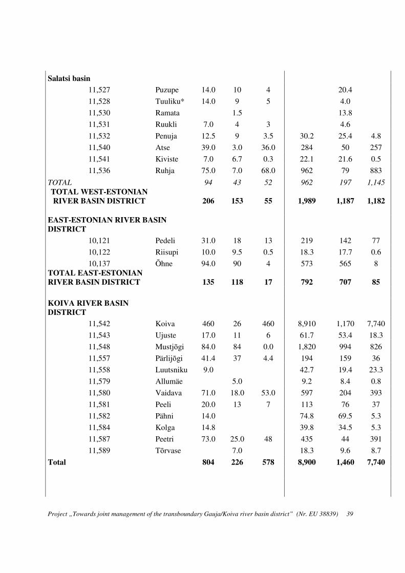
Project „Towards joint management of the transboundary Gauja/Koiva river basin district” (Nr. EU 38839) 39
Salatsi basin
11,527 Puzupe 14.0 10 4 20.4
11,528 Tuuliku* 14.0 9 5 4.0
11,530 Ramata 1.5 13.8
11,531 Ruukli 7.0 4 3 4.6
11,532 Penuja 12.5 9 3.5 30.2 25.4 4.8
11,540 Atse 39.0 3.0 36.0 284 50 257
11,541 Kiviste 7.0 6.7 0.3 22.1 21.6 0.5
11,536 Ruhja 75.0 7.0 68.0 962 79 883
TOTAL 94 43 52 962 197 1,145
TOTAL WEST-ESTONIAN
RIVER BASIN DISTRICT 206 153 55 1,989 1,187 1,182
EAST-ESTONIAN RIVER BASIN
DISTRICT
10,121 Pedeli 31.0 18 13 219 142 77
10,122 Riisupi 10.0 9.5 0.5 18.3 17.7 0.6
10,137 Õhne 94.0 90 4 573 565 8 TOTAL EAST-ESTONIAN
RIVER BASIN DISTRICT 135 118 17 792 707 85
KOIVA RIVER BASIN
DISTRICT
11,542 Koiva 460 26 460 8,910 1,170 7,740
11,543 Ujuste 17.0 11 6 61.7 53.4 18.3
11,548 Mustjōgi 84.0 84 0.0 1,820 994 826
11,557 Pärlijōgi 41.4 37 4.4 194 159 36
11,558 Luutsniku 9.0 42.7 19.4 23.3
11,579 Allumäe 5.0 9.2 8.4 0.8
11,580 Vaidava 71.0 18.0 53.0 597 204 393
11,581 Peeli 20.0 13 7 113 76 37
11,582 Pähni 14.0 74.8 69.5 5.3
11,584 Kolga 14.8 39.8 34.5 5.3
11,587 Peetri 73.0 25.0 48 435 44 391
11,589 Tōrvase 7.0 18.3 9.6 8.7
Total 804 226 578 8,900 1,460 7,740
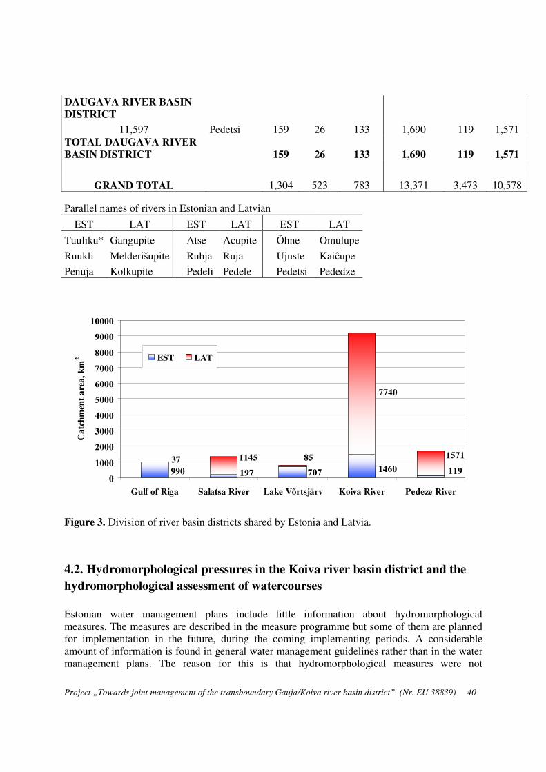
Project „Towards joint management of the transboundary Gauja/Koiva river basin district” (Nr. EU 38839) 40
DAUGAVA RIVER BASIN
DISTRICT
11,597 Pedetsi 159 26 133 1,690 119 1,571 TOTAL DAUGAVA RIVER
BASIN DISTRICT 159 26 133 1,690 119 1,571
GRAND TOTAL 1,304 523 783 13,371 3,473 10,578
Parallel names of rivers in Estonian and Latvian
EST LAT EST LAT EST LAT
Tuuliku* Gangupite Atse Acupite Õhne Omulupe
Ruukli Melderišupite Ruhja Ruja Ujuste Kaiĉupe
Penuja Kolkupite Pedeli Pedele Pedetsi Pededze
Figure 3. Division of river basin districts shared by Estonia and Latvia.
4.2. Hydromorphological pressures in the Koiva river basin district and the
hydromorphological assessment of watercourses
Estonian water management plans include little information about hydromorphological measures. The measures are described in the measure programme but some of them are planned for implementation in the future, during the coming implementing periods. A considerable amount of information is found in general water management guidelines rather than in the water management plans. The reason for this is that hydromorphological measures were not
990 707 1460 119197
37 1145 85 1571
7740
0
1000
2000
3000
4000
5000
6000
7000
8000
9000
10000
Gulf of Riga Salatsa River Lake Võrtsjärv Koiva River Pedeze River
Ca
tch
men
t a
rea
, k
m2 EST LAT

Project „Towards joint management of the transboundary Gauja/Koiva river basin district” (Nr. EU 38839) 41
determined by the time the water management plans were prepared and adopted. The aim of the main hydromorphological measures is to open rivers for fish migration, protect the spawning sites downstream from dams and ensure a suitable hydrological regime for salmonids downstream from dams. In general, hydromorphological measures, such as demolition of dams and construction of fish passes, are foreseen for all heavily modified water bodies but the plans have been unrealistic and in some locations these are not essential measures in improving the hydromorphological status of rivers. No surface water is extracted from the rivers of the Koiva river basin district and no flooded areas have been established; therefore the factors influencing the hydrological regime are not taken into account. Dams
There are 21 dams in the Koiva river basin district. The majority of them are quite old (older than 30—40 years). Dams were the main reason for the poor hydrological condition of the Pärlijõgi river and the Vaidava river (partially). At present, the construction of fish passes on the dams on both rivers has been completed or nearly completed. This will ensure the migration of fish along the rivers and a good status of these water bodies. A fish pass was completed on the Vaidava river in Vastse-Roosa in the autumn of 2012. The last fish passes on the Pärlijõgi river and a fish pass on the Krabi dam on the Kolga river will be constructed in 2013. Land reclamation
Land reclamation has historically been the main reason for the modification of water bodies: rivers have been dredged and straightened and the water level of lakes lowered. Land reclamation has had a significant impact on small and medium-sized water bodies, turning a large part of them into artificial recipients and causing significant physical changes. Many artificial lakes that make the water habitats more diverse have been created in the course of land reclamation. In reaches with deep gradient, land reclamation has reduced the diversity of habitats. About 40 years ago, extensive drainage works were carried out in the Koiva river basin district. Over time, the ditches have become partly natural, which may ensure the good ecological status of water bodies in the long term. In such cases, there is no need to classify the artificial recipients created as a result of land reclamation as modified water bodies. The final assessment can only be given, however, based on fieldwork data concerning the specific water bodies. In the Koiva river basin district, there are a total of 253 km2 of drained areas – 19% of the total area of the river basin district. The total length of state-maintained artificial recipients is 73.5 km. Artificial recipients created as a result of land reclamation are maintained in order to improve the runoff conditions, especially during floods. A large part of the drainage system was constructed more than 30 years ago and needs to be repaired or reconstructed. In the last decade, land reclamation has been aimed at giving watercourses a more natural look. In the Koiva river basin district, land reclamation has had a significant impact on the upstream of Mustjõgi river (water body Mustjõe_2) the catchment area of which includes large areas of drained forest. The reach is included in the list of state-maintained artificial recipients as a whole (18.7 km). Due to land reclamation, this reach is classified as a heavily modified watercourse.
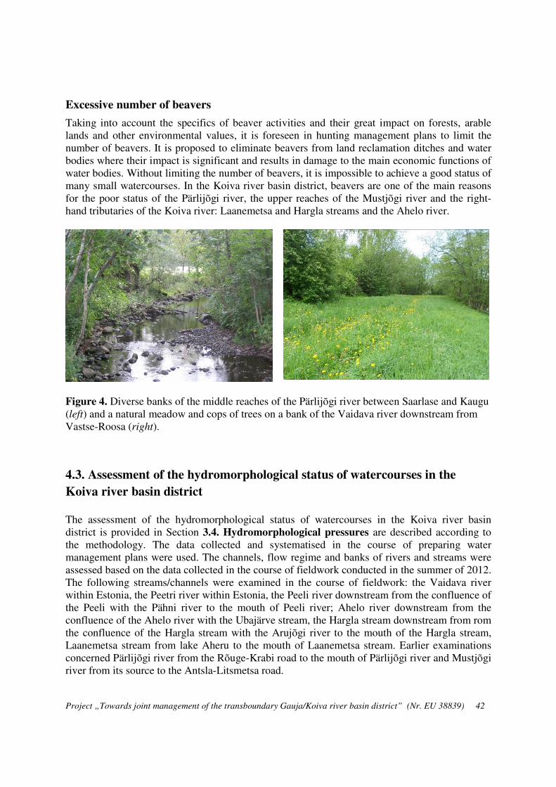
Project „Towards joint management of the transboundary Gauja/Koiva river basin district” (Nr. EU 38839) 42
Excessive number of beavers
Taking into account the specifics of beaver activities and their great impact on forests, arable lands and other environmental values, it is foreseen in hunting management plans to limit the number of beavers. It is proposed to eliminate beavers from land reclamation ditches and water bodies where their impact is significant and results in damage to the main economic functions of water bodies. Without limiting the number of beavers, it is impossible to achieve a good status of many small watercourses. In the Koiva river basin district, beavers are one of the main reasons for the poor status of the Pärlijõgi river, the upper reaches of the Mustjõgi river and the right-hand tributaries of the Koiva river: Laanemetsa and Hargla streams and the Ahelo river.
Figure 4. Diverse banks of the middle reaches of the Pärlijõgi river between Saarlase and Kaugu (left) and a natural meadow and cops of trees on a bank of the Vaidava river downstream from Vastse-Roosa (right).
4.3. Assessment of the hydromorphological status of watercourses in the
Koiva river basin district
The assessment of the hydromorphological status of watercourses in the Koiva river basin district is provided in Section 3.4. Hydromorphological pressures are described according to the methodology. The data collected and systematised in the course of preparing water management plans were used. The channels, flow regime and banks of rivers and streams were assessed based on the data collected in the course of fieldwork conducted in the summer of 2012. The following streams/channels were examined in the course of fieldwork: the Vaidava river within Estonia, the Peetri river within Estonia, the Peeli river downstream from the confluence of the Peeli with the Pähni river to the mouth of Peeli river; Ahelo river downstream from the confluence of the Ahelo river with the Ubajärve stream, the Hargla stream downstream from rom the confluence of the Hargla stream with the Arujõgi river to the mouth of the Hargla stream, Laanemetsa stream from lake Aheru to the mouth of Laanemetsa stream. Earlier examinations concerned Pärlijõgi river from the Rõuge-Krabi road to the mouth of Pärlijõgi river and Mustjõgi river from its source to the Antsla-Litsmetsa road.

Project „Towards joint management of the transboundary Gauja/Koiva river basin district” (Nr. EU 38839) 43
A integrated assessment of the hydromorphological status was prepared according to the 5-band assessment system in Table 8 “Assessment of the impact of pressure factors on the hydromorphological status of watercourses”. In Table 10, the Mustjõe water body 1154800_2, which includes the lower reaches of the Mustjõgi river from Antsla-Litsmetsa road to the mouth of Pärlijõgi river, has been previously classified in the Koiva river basin district water management plan as a heavily modified water body; the rest are all natural water bodies. Today, this heavily modified water body can be considered as a reach with a good status. The results of the assessment indicate that the pressure factor “Water extraction and re-routing” has no impact on the status of water bodies. The pressure factor “changing the flow regime” is taken into account in the case of those rivers and streams with a small catchment area that have many beaver dams, due to which sections that had flowing water have become areas of standing water. For the same reason, these small rivers and streams are classified as heavily modified by impounding. The results of the assessment of the bank structure are good because there are very few cultivated banks; natural and near-natural communities are dominating on riverbanks. In general, the hydromorphological status of the majority of the watercourses in the Koiva river basin district is good or very good. The status of Ahelo river and the Laanemetsa and Hargla streams is poor for the above reasons. However, all watercourses are characterised by wood debris in their channel. It is caused on the one hand by beavers and on the other hand by neglected forests – big trees and their roots have fallen into rivers, which increases the load of suspended solids.
Figure 5. Limestone bank in the middle reaches of the fast-flowing Peetri river (left) and debris collecting behind a fallen tree on the Vaidava river (right).

Project „Towards joint management of the transboundary Gauja/Koiva river basin district” (Nr. EU 38839) 44
Table 10. Hydromorphological consolidates assessment of Estonian rivers in the Koiva river basin district. Abbreviations: VS – status of river channel, VV – water extraction and re-routing, PA – impounding, VO – changing the flow regime, KA – bank structure.
Code Name Type VS VV PA VO KA Total Status class
1154200_1 Koiva 3B 1.0 0.8 0.6 0.4 0.2 3.0 very good
1154300_1 Ujuste 1A 1.0 0.8 2.4 0.8 0.6 5.6 good
1154600_1 Laanemetsa 1A 4.0 0.8 2.4 0.8 0.4 8.4 poor
1154800_1 Mustjõgi from the source to the Antsla-Litsmetsa road
1A 2.0 0.8 1.8 0.4 0.6 5.6 good
1154800_3 Mustjõgi from Pärlijõgi river to Raudsepa stream
2B 1.0 0.8 0.6 0.4 0.2 3.0 very good
1154800_4 Mustjõgi from Raudsepa stream to the Koiva-Mustjõe meadow conservation unit
2B 1.0 0.8 0.6 0.4 0.2 3.0 very good
1154800_5 Mustjõgi from the Koiva-Mustjõe meadow conservation unit to the national border
2B 1.0 0.8 0.6 0.4 0.2 3.0 very good
1155700_1 Pärlijõgi to Saarlase dam 1A 1.0 0.8 1.8 0.4 0.4 4.4 very good
1155700_2 Pärlijõgi from Saarlase dam to the river mouth
2B 1.0 0.8 1.2 0.8 0.4 4.2 very good
1157400_1 Ahelo 1A 4.0 0.8 2.4 0.4 0.6 8.2 poor
1157600_1 Kuura 1A 2.0 0.8 1.2 0.4 0.2 4.6 very good
1158000_1 Vaidava to Vastse-Roosa dam 2B 1.0 0.8 1.2 0.4 0.2 3.6 very good
1158000_2 Vaidava from Vastse-Roosa dam to the river mouth
2B 1.0 0.8 0.6 0.4 0.2 3.0 very good

Project „Towards joint management of the transboundary Gauja/Koiva river basin district” (Nr. EU 38839) 45
1158100_1 Peeli 1B 2.0 0.8 1.2 0.4 0.4 4.8 very good
1158400_1 Kolga 1B 1.0 0.8 1.2 0.4 0.2 3.6 very good
1158700_1 Peetri 2B 1.0 0.8 0.6 0.4 0.2 3.0 very good
1159300_1 Hargla 1A 3.0 0.8 2.4 0.8 0.6 7.6 poor
1159700_1 Pedetsi 1A 2.0 0.8 2.4 0.4 0.2 5.8 good
1160200_1 Punaoja 1A 2.0 0.8 0.6 0.4 0.2 4.0 good
1154800_2 Mustjõgi from the Antsla-Litsmetsa
road to Pärlijõgi river
TMV 4.0 0.8 1.2 0.4 0.8 7.2 good

Project „Towards joint management of the transboundary Gauja/Koiva river basin district” (Nr. EU 38839) 46
4.4 Assessment of the hydromorphological status of watercourses in the Koiva
river basin district according to the standard “EVS-EN 15843:2010 Water
quality – Guidance standard on determining the degree of modification of
river hydromorphology”
This chapter provides an assessment of the hydromorphological status of Estonian watercourses according to the methodology described in the standard “EVS-EN 15843:2010”. The standard is described in Section 2.2. and some characteristics have been described in more detail in Sections 3.2. and 3.4. According to the standard, all hydromorphological features are divided into two groups:
1) core features and
2) subsidiary features.
In the assessment of the hydromorphological status of watercourses, these features are taken into account by using the weight of 1.0 or 0.5. Therefore, the core features are twice as important as the subsidiary features. The consolidated assessment is calculated as an arithmetic mean of all features. The criteria of the consolidated assessment are given in Table 7. The assessment was done by officially established water bodies of the Koiva river basin district and the results are presented in Table 11. Next, we will explain how the features were assigned values. The following features were left out of the assessment:
3a – aquatic vegetation management;
6 – longitudinal continuity as affected by artificial structures.
In the case of the water bodies of the Pärlijõgi river (1155700_1 and 1155700_2), it was taken into account that not all dams have fish passes. The low status of the channel of Laanemetsa stream, Ahelo river and Hargla stream is caused by numerous beaver dams and the resulting floods, which in turn affect the status of the water body as a whole. According to the expert opinion, the status of the watercourses in the Koiva river basin district is very good or good, apart from the Laanemetsa and Hargla streams where the status is “poor”. The status of the water body Mustjõgi 1154800_2 (a heavily modified water body) in the upper reaches of the Mustjõgi river is also poor.

Project „Towards joint management of the transboundary Gauja/Koiva river basin district” (Nr. EU 38839) 47
Table 11. Assessment of the hydromorphological status of watercourses in the Koiva river basin district according to the standard “EVS-EN 15843:2010 Water quality – Guidance standard on determining the degree of modification of river hydromorphology.”
Feature Core feature Subsidiary feature
Importance
Ujuste 1154300_
1 Ahelo
1157400_1 Laanemetsa 1154600_1
Hargla 1159300_1
Mustjõgi 1154800_1
Mustjõgi 1154800_3
1. CHANNEL GEOMETRY 1a) Planform + 1.0 1 2 3 3 3 2 1b) Long-section and cross-section
+ 1.0 1 2 3 3 4 1
2. SUBSTRATES 2a) Artificial material + 1.0 1 3 3 3 2 1 2b) Natural material + 0.5 1 1.5 2 2 1.5 1 3. CHANNEL VEGETATION AND ORGANIC DEBRIS
3b) Woody debris and floating debris
+ 0.5 0.5 1.5 2 2 2 0.5
4. EROSION/DEPOSITION CHARACTER
+ 0.5 0.5 0.5 1.5 1.5 1.5
5. FLOW 5a) Artificial in-channel structures + 1.0 1 1 4 4 3
5b) Effects of catchment area management on discharge
+ 1.0 1 1 1 1 1 1
5c) Effects of daily flow alteration + 1.0 1 1 1 1 1 1 7. BANK STRUCTURE + 1.0 1 2 3 3 2 1 8. VEGETATION TYPE/STRUCTURE ON BANKS AND ADJACENT LAND
+ 1.0
1 3 2 2 2 2 9. ADJACENT LAND-USE + 1.0
1 2 2 3 2 2 10. CHANNEL-FLOODPLAIN INTERACTIONS
10a) Degree of lateral connectivity of river and floodplain
+ 1.0 1 3 2 3 2 1
10b) Degree of lateral movement of river channel
+ 1.0 1 3 3 3 2 1
INTEGRATED ASSESSMENT 1.0 2.1 2.6 2.8 2.3 1.3

Project „Towards joint management of the transboundary Gauja/Koiva river basin district” (Nr. EU 38839) 48
Feature Core feature
Subsidiary feature
Importance Vaidava 1158000_1
Vaidava 1158000_2
Peeli 1158100_1
Kolga 1158400_1
Peetri 1158700_1
Mustjõgi
1154800_2
1. CHANNEL GEOMETRY 1a) Planform + 1 1 1 2 2 1 4 1b) Long-section and cross-section
+ 1 1 1 2 1 1 3
2. SUBSTRATES 2a) Artificial material + 1 1 1 2 2 1 3 2b) Natural material + 0.5 1 1 1.5 1.5 0.5 2 3. CHANNEL VEGETATION AND ORGANIC DEBRIS
3b) Woody debris and floating debris
+ 0.5 1 0.5 1 1 0.5 1
4. EROSION/DEPOSITION CHARACTER
+ 0.5 0.5 0.5 1 1 0.5 1
5. FLOW 5a) Artificial in-channel structures
+ 1 1 1 2 2 1 2
5b) Effects of catchment area management on discharge
+ 1 1 1 1 1 1 1
5c) Effects of daily flow alteration
+ 1 1 1 1 1 1 1
7. BANK STRUCTURE + 1 1 1 2 2 1 4 8. VEGETATION TYPE/STRUCTURE ON BANKS AND ADJACENT LAND
+ 1
2 2 2 2 3 3 9. ADJACENT LAND-USE + 1 2 2 2 2 3 3 10. CHANNEL-FLOODPLAIN INTERACTIONS
10a) Degree of lateral connectivity of river and floodplain
+ 1
1 1 1 1 1 0 10b) Degree of lateral movement of river channel
+ 1
1 1 2 2 1 4 INTEGRATED
ASSESSMENT 1.2 1.2 1.8 1.7 1.3 2.6

Project „Towards joint management of the transboundary Gauja/Koiva river basin district” (Nr. EU 38839) 49
5. OVERVIEW OF DATA SOURCES FOR THE ASSESSMENT AND
IMPROVEMENT OF THE HYDROMORPHOLOGICAL STATUS OF
WATERCOURSES Various information can be used to assess the hydromorphological status of water bodies and watercourses in particular. To date, this information has not been used for one specific purpose, i.e. morphological analysis. Information sources exist in different forms and the most important of them are:
• Printed publications (books, articles, maps) that can be used to prepare an overview of the natural conditions of water bodies and their catchment areas, socio-economic situation and nature conservation measures.
• Manuscripts, the most important of which are:
a) The materials preserved in the archives of the Estonian Environment Agency (former Estonian Meteorological and Hydrological Institute - EMHI) concerning the hydrographical studies of rivers in the 1950s and 1960s.
b) Materials preserved in the archives of former land reclamation bureaus in county centres concerning the studying measuring, design and use of artificial recipients created as a result of land reclamation (starting from the middle of the 20th century).
c) Materials of the limnology centre of the Estonian University of Life Sciences concerning the biological studies of rivers and the monitoring of biota; these activities have included and continue to include the measurement of river channels, sediments, depth, flow velocity, banks, etc.
d) Management plans of special conservation areas of Natura 2000 approved by the Environmental Board and the data of the inventory carried out in the course of preparing the plans.
e) The research materials and projects related to the management of watercourses funded by the Environmental Investment Centre.
f) The reports of applied research commissioned by the Ministry of the Environment, which are available on the ministry's website.
g) Materials of hydrological monitoring starting from the early 1920s preserved in the archives of the EMHI. The most important of these materials are: monitoring data of water level, runoff, water temperature and ice conditions.
h) Bachelor’s and master’s theses concerning applied subjects and specific water bodies.
• The most important digital databases:
a) Data from the Estonian Environmental Information System on water extraction and effluent discharge by individual objects.

Project „Towards joint management of the transboundary Gauja/Koiva river basin district” (Nr. EU 38839) 50
b) GIS-based data sets concerning water bodies and their catchment areas; the majority of these data sets are held in national registers; the most important data sets are the map layers of water bodies and catchment areas.
c) Data on runoff from Estonian rivers (daily average and monthly smallest and biggest discharges).
d) Database of environmental permits, including permits for the special use of water. Data on impounding and dams related to impounding permits.
e) The geoportal of the Estonian Land Board. On the basis of maps, orthographic photos and LIDAR data, it is possible to get a detailed overview of the location of watercourses, land use on riverbanks and floodplains.
f) Digital information broken down by water bodies, parts of water bodies, sub-basins and river basin districts collected in relation with preparing water management plans.
g) Materials collected by the Agricultural Board in relation to preparing land reclamation plans and creating land reclamation systems. Mainly contains information about state-maintained artificial recipients created in the course of land reclamation.
The following works should be carried out in relation to the hydromorphological analysis of watercourses and the assessment of their status:
1) Preparing detailed longitudinal profiles of rivers and creating a database that will allow for determining the differences in the gradient and the resulting flow regime along the river. By combining the data from different sources and using digital data, we can give a detailed overview by different reaches. The results can be used to plan measures for the management of watercourses. The department of geography of the University of Tartu is preparing to undertake this work.
2) Analysis of the runoff of rivers. For this purpose, we can use the data of the Konnuvere water level monitoring point on the Mustjõgi river from 1931—1960 and the data of the recent years collected by the new hydrometric station on the Mustjõgi river. We will also need the daily data on runoff from the Ape hydrometric station on the Vaidva river in Latvia. The Vaidva river has been monitored for quite a long time: continuous measurements have been carried out from the middle of the 20th century.
3) A detailed study of the channels and banks of small watercourses is needed in order to plan specific measures to improve the hydromorphological status of these watercourses. Such applied studies are mainly required on the Laanemetsa and Hargla streams and Ahelo and Peeli rivers that are blocked by numerous beaver dams and fallen trees that collect floating debris.

Project „Towards joint management of the transboundary Gauja/Koiva river basin district” (Nr. EU 38839) 51
CONCLUSIONS
This expert opinion draws on the findings of studies conducted in other EU member states; the choice of assessment criteria is largely based on the recommendations of the standard “EVS-
EN 15843:2010 Water quality – Guidance standard on determining the degree of modification of
river hydromorphology”.The assessment is based on the physical parameters of watercourses and the methodology reflects their typological differences. The existing databases are used and some parameters are collected in the field. The determination of reference conditions is somewhat ambiguous.
In the Estonian context, the hydromorphological features that should be taken into account in assessing the ecological status of rivers are flow regime, sinuosity, variability of width and depth and the nature of buffer zones on the banks. These elements should ensure natural diversity and the existence of numerous habitats in rivers.
Flow velocity is not a suitable feature because it varies greatly depending on the river discharge. Therefore, it is recommended to use gradient instead of flow velocity because gradient is easily determined, expressed in numerical value and reflects directly flow velocity. Gradient and sinuosity can be used as suitable integral characteristics in hydromorphological assessment of rivers.
The morphological status of the river channel can be assessed both along the channel and by cross-sections. Taking into account that the assessment by cross-sections requires additional measurements, the more widely used method is to assess the status of the river channel along the channel, which allows for using the longitudinal profile of the river as an important information source.
A problem specific to Estonia is the high number of beavers and beaver dams on rivers and streams, which have an adverse effect on the hydromorphological status of watercourses. Although not human-induced, the impact of this pressure factor on aquatic biota, including fish fauna is obvious. This paper takes the impact of beaver dams into account as an additional pressure factor influencing the status of watercourses.
Assessing the structure of banks means that the share of natural and near-natural lands and cultivated land is determined. These are considered to be a buffer zone that protects the water body against diffuse pollution.
We have used the criteria laid down in the standard “EVS-EN 15843:2010 Water quality –
Guidance standard on determining the degree of modification of river hydromorphology”, except when assessing the impact of impounding because the standard does not contain the relevant criteria.
The classification includes five hydromorphological features, each of which has a different weight and can have a value on a 5-point scale. The integrated assessment of the hydromorphological status takes into account the importance of each feature, which helps to distinguish more relevant features from those that are less relevant and to make the result more objective.

Project „Towards joint management of the transboundary Gauja/Koiva river basin district” (Nr. EU 38839) 52
The hydromorphological status of the majority of the watercourses in the Koiva river basin district is good or very good. The status of the Ahelo river and the Laanemetsa and Hargla streams is poor due to beaver dams and the resulting changes in the flow regime.

Project „Towards joint management of the transboundary Gauja/Koiva river basin district” (Nr. EU 38839) 53
References
Griffiths, R. E., Anderson, D. E., Springer A. E., 2008. The morphology and hydrology of small spring-dominated channels. Geomorphology, 102: 511–521.
Ilnicki, P., Gorecki, K., Grzybowski, M., Krzeminska, A., Lewandowski, P., Sojka, M. 2010. Principles of hydromorphological surveys of Polish rivers. Journal of Water and Land Development. No. 14, 2010: 3–13.
Ilnicki, P., Gorecki, K., Grzybowski, M., Krzeminska, A., Lewandowski, P., Sojka, M. 2010. Ecological quality classes of river hydromorphology in Poland. Journal of Water and Land Development. No. 14, 2010: 15–27.
Järvet, A., Jaanus, M. 2012. Kui looklevad on meie jõed. Eesti Loodus, 6/7.
Lehotský, M., Grešková, A. 2007. Fluvial geomorphological approach to river assessment – methodology and procedure. Geografický časopis, 59, 2, 107–129.
Loigu, E. (responsible person). 2003. Pinnaveekogude ökoloogilise klassifikatsiooni väljatöötamine ja süsteemi kontroll looduses. Commissioned by: Ministry of the Environment (Contract for Services No 18-25/185).
Mansikkaniemi, H., 1970. The Sinuosity of Rivers in Northern Finland. Turun yliopiston
maantieteen laitoksen julkaisuja, 52.
Reihan, A. (responsible person). 2008. Ökoloogilise miinimumvooluhulga arvutusmetoodika väljatöötamine. The Department of Environmental Engineering of the Tallinn University of Technology, Commissioned by the Ministry of the Environment,
Philip Mc Ginnity, Paul Mills, William Roche and Markus Müller. Water Framework Directive: A desk study to determine a methodology for the monitoring of the ‘morphological conditions’ of Irish Rivers (2002-W-DS/9). Final Report.
Rinaldi, M., Surinam, N., Comiti, F., Bussettini, M. 2012. Guidebook for the evaluation of stream morphological conditions by the Morphological Quality Index (MQI). Version 1.1. Rome, 2012.
Timm, H. (ed.). 2003. Euroopa vee raamdirektiivile vastavad kvaliteedielemendid bioloogilise seisundi klassifitseerimiseks Eesti vooluvetes. Commissioned by: Ministry of the Environment,
Schumm, S. A. 2005. River Variability and Complexity. Cambridge University Press.
Standard “EVS-EN 15843:2010 Water quality – Guidance standard on determining the degree of modification of river hydromorphology”