hydrologic information – metadata summary of the grdc hydrology metadata mode is prepared as basis...
TRANSCRIPT
Report 39 (under review)
Global Runoff Data Centre GRDC operates under the auspices of the World Meteorological Organization (WMO) with the support of the Federal Republic of Germany within the Federal Institute of Hydrology (BfG)
Hydrologic Information – Metadata Semantic structure for the description of hydrologic data (GRDC Hydrologic Metadata) - ongoing project -
Summary prepared for the 14th session of WMO CHy
Hydrologic Information – Metadata (GRDC Hydrologic Metadata) Summary prepared for the 14th session of the WMO Commission for Hydrology
2 DRAFT 15/10/2012
Global Runoff Data Centre in the
Federal Institute of Hydrology (BfG) P.O.Box 20 02 53 56002 Koblenz, Germany Phone: +49 261 1306-5224 Fax: +49 261 1306-5722 E-Mail: [email protected] Internet:http://grdc.bafg.de
October 2012 2nd, completely revised edition that replaces the final draft version of July 2009 (1st ed.)
Editor:
I. Dornblut, Federal Institute of Hydrology, Global Runoff Data Centre (GRDC)
About the Global Runoff Data Centre (GRDC):
The GRDC is acting under the auspices of the World Meteorological Organization (WMO) and is supported by WMO Resolutions 21 (Cg XII, 1995) and 25 (Cg XIII, 1999). Its primary task is to maintain, extend and promote a global database on river discharge aimed at supporting international organizations and programs by serving essential data and products to the international hydrologic and climate research and assessment community in their endeavour to better understand the earth system. The GRDC was established at the Federal Institute of Hydrology in 1988. The National Hydrological and Meteorological Services of the 187 member states of WMO are the principal data providers for GRDC.
Document history:
Version Date Editor Primary clause modified
Remarks
0.1 15.10.2012 I.Dornblut Draft prepared, incl. Annexes A and B
Hydrologic Information – Metadata (GRDC Hydrologic Metadata) Summary prepared for the 14th session of the WMO Commission for Hydrology
3 DRAFT 15/10/2012
Contents Preface to the summary of October 2012................................................................................... 5 Preface........................................................................................................................................ 5 Future work ................................................................................................................................ 5 1 Introduction .................................................................................................................... 6 2 Scope .............................................................................................................................. 7 3 Conformance to ISO and OGC standards ...................................................................... 7 3.1 ISO 19115: Metadata ..................................................................................................... 7 3.2 OGC WaterML2.0 Part 1: Time series implementation standard .................................. 8 3.2.1 Overview (extracted from OGC 10-126r3) ................................................................. 8 3.3 HY_Features, a common hydrologic feature model ...................................................... 9 3.3.1 Scope (extracted from OGC 11-039r2) ....................................................................... 9 3.3.2 Basic concept (extracted from OGC 11-039r2) .......................................................... 9 4 Core concept................................................................................................................. 10 4.1 GRDC_Dataset............................................................................................................. 10 4.1.1 GRDC_ GriddedDataSet ........................................................................................... 11 4.1.2 GRDC_ PointShapeFile ............................................................................................ 11 4.1.3 GRDC_ LineShapeFile ............................................................................................. 11 4.1.4 GRDC_ PolygonShapeFile ....................................................................................... 11 4.1.5 GRDC_ TimeSeries................................................................................................... 11 4.2 DAR-Metadata (WIS Metadata) .................................................................................. 11 4.2.1 GRDC_DatasetDescription ....................................................................................... 11 4.3 ObservationalMetadata (WIGOS Metadata) ................................................................ 12 4.3.1 GRDC_TVPObservation........................................................................................... 12 4.3.2 GRDC_Station .......................................................................................................... 12 4.3.3 Hydro_Variable......................................................................................................... 12 4.3.4 GRDC_DataGenerationProcess ................................................................................ 13 4.4 EXT_Utilities ............................................................................................................... 13 4.4.1 SpatialCoverageObservation..................................................................................... 13 4.4.2 ObservationProcessUsed........................................................................................... 13 4.4.3 Phenomenon (ObservedObservable)......................................................................... 13 5 Further work................................................................................................................. 14 References ................................................................................................................................ 15
ANNEX A: GRDC Hydrologic Metadata Data Dictionary ..................................................... 16 Table 1: GRDC_Metadata........................................................................................................ 17 Table 2: EXT_Utilities ............................................................................................................. 24 ANNEX B: HY_Features Data Dictionary .............................................................................. 33 Table 3: HY_Features (main)................................................................................................... 34 Table 4: HY_HydroGeologicUnit ............................................................................................ 35 Table 5: HY_HydroFeature...................................................................................................... 35 Table 6: HY_AtmosphericFeature ........................................................................................... 48 Table 7: HY:SubsurfaceHydroFeature..................................................................................... 50 Table 8: HY_SurfaceHydroFeature ......................................................................................... 53 Table 9: HY_HydrometricNetwork ......................................................................................... 57 Table 10: HY_Utilities ............................................................................................................. 59

Hydrologic Information – Metadata (GRDC Hydrologic Metadata)
4 DRAFT 15/10/2012
Hydrologic Information – Metadata (GRDC Hydrologic Metadata) Summary prepared for the 14th session of the WMO Commission for Hydrology
5 DRAFT 15/10/2012
Preface to the summary of October 2012 This summary of the GRDC Hydrology Metadata mode is prepared as basis for discussions at the 14th session of the WMO Commission for Hydrology in November 2012. The document refers to ongoing work towards GRDC Hydrology Metadata profile. It will be further developed into the detailed description of the GRDC Hydrology Metadata concept and will replace the 1st draft of the GRDC Metadata profile of July 2009. Recipients of this document are invited to provide supporting documentation. Suggested additions, changes, and comments on this report are welcome and encouraged.
Preface This document describes the GRDC Hydrology Metadata conceptual model. It is distributed for review and comment and is subject to change without notice. This document is a completely revised version of the GRDC Hydrologic Metadata documentation and replaces the document of July 2009.
The revised 2nd edition emerges from the adjustment and complete re-arrangement of the GRDC Hydrologic Metadata conceptual UML model taking into account the recent developments to improve the sharing of information and data in the domain of hydrology, particularly the OGC WaterML2.0 Part 1: Time series standard and the HY_Features common hydrologic feature model currently documented in an OGC discussion paper.
Future work • The GRDC Hydrologic Metadata model will use WMO Core Metadata profile
(ongoing work within WIS) to provide the metadata needed for Data, Access and Retrieval (DAR) services.
It is expected that the evolving specialisation of the ISO 19115 standard will provide the framework for the description of GRDC hydrologic data sets, particularly regarding the temporal representation of observation data such as time series.
• To provide the observational information, the GRDC Hydrologic Metadata model will use concepts developed in the OGC/WMO Hydrology DWG such as of WaterML2.0 and the HY_Features conceptual model. Although developed under the guidance of the OGC, these hydrology-related concepts needs to be maintained by the addressed community, i.e. by the community of the WMO Member countries represented in the WMO CHy.
It is expected that CHy will recommend the evaluation of these concepts for applicability and use by the WMO Commission for Basic systems (WMO CBS).
• The GRDC Hydrologic Metadata model use references to semantic concepts and common definitions which are typically defined and managed in standard models, reference data sets or vocabularies which are controlled by various authorities and increasingly accessible via web services. Using URL based identifiers for such references the identifier may be linked to its information resource, ambiguity may be reduced and further information can be retrieved more easily.
Hydrologic Information – Metadata (GRDC Hydrologic Metadata) Summary prepared for the 14th session of the WMO Commission for Hydrology
6 DRAFT 15/10/2012
It is expected that CHy will recommend the validation of an URL based identifier approach by the WMO Commission for Basic systems (WMO CBS) for referencing common concepts and identifiers.
• The GRDC Hydrologic Metadata model is intended to implemented as part of a future GRDC Data Management System enabling system interoperability by offering the data held and maintained at the GRDC to Discovery, Access and Retrieval (DAR) services conform to the standards of the ISO 19000 standard series.
Primarily developed for data sets created by the GRDC, the basic concepts may be generally applicable to jointly provide DAR and observational information about similar data sets, particularly in data collection projects on a global scale like the GTN-H. The validation of concepts by the addressed community and test implementations are required to further develop the proposed metadata concepts to submission as a candidate best practice.
1 Introduction The GLOBAL RUNOFF DATA CENTRE (GRDC) is the world-wide archive of river discharge data. It operates under the auspices of the World Meteorological Organization (WMO) with support from the Federal Republic of Germany. The exchange of hydrological data and information at a global level in support of research, hydrological applications and water resources management is the principal reason for the operation of the GRDC.
Recognizing that the lack of standardization is one of the major obstacles in the practice of data exchange, the WMO Technical Commission for Hydrology (CHy) during its thirteenth session (2009) had encouraged the GRDC to step up the efforts towards the development of a standardised hydrologic metadata profile in collaboration with interested parties under the overall guidance of WIS/WIGOS. Likewise, since 2001, the establishment of standardised metadata descriptions under the leadership of GRDC is a core project of the Global Terrestrial Network – Hydrology (GTN-H) that is being implemented by the Hydrology and Water Resources Programme (HWRP) of WMO and the Global Climate Observing System (GCOS).
Since mid 2009, the OGC Hydrology Domain Working Group (Hydrology DWG) has been working to improve the discoverability, accessibility and usability of water related information. This joint working group of the World Meteorological Organisation (WMO) and the Open Geospatial Consortium (OGC) consists of members from government, research and the commercial sectors.
In September 2012, the OGC adopted WaterML2.0 Part 1: Time series as an OGC Standard. for encoding water observation time series. WaterML2.0 builds on widely used Internet and Web interface and encoding standards and enables any online collection of water data to become part of a water information network. The work that produced this standard is ongoing, as WaterML2.0 Part 1 is just the first in a series of planned enhancements and extensions. Current work WaterML2.0 involves standardised communication of descriptions of surface and groundwater features and water quality issues.
GRDC is an integral partner in all of the aforementioned programmes and activities. GRDC contributed to the development of the HY_Features: a common hydrologic feature model. The HY_Features model is intended to describe hydrologic features referenced in various data sets in current use and to form a basis for a common and stable referencing of features to assist the organisation of their observation and modelling as well as the aggregation of generated data into integrated suites of datasets on a global, regional, national or basin scale.
Hydrologic Information – Metadata (GRDC Hydrologic Metadata) Summary prepared for the 14th session of the WMO Commission for Hydrology
7 DRAFT 15/10/2012
Defining the semantics of features which are the overall object of study and reporting in hydrology across scientific sub-disciplines, it provides a means to identify these features independent from scales and enables multiple representations of these features in the real world to be linked to the shared unit of study or reporting. A discussion process has been started 2012 under the guidance of the WMO/OGC Hydrology DWG.
2 Scope The initial scope of the GRDC Hydrologic Metadata model is defined by the concerns of WMO-CHy to facilitate the data sharing within the hydrologic community of the WMO Member countries and to improve the quality of data products based in these data.
The exchange of hydrological data and information on the global scale is the principal reason for operating of GRDC. Its primary objective consists in supporting the water and climate related programmes and projects of the United Nations, its specialised agencies and the scientific research community by collecting and disseminating hydrological data across national borders in a long-term perspective. GRDC has been serving for more than twenty years successfully as a facilitator between the producers of hydrologic data and the international research community.
The data collected and maintained by the GRDC result from observations undertaken by the National Hydrological Services. To comprehensively identify and evaluate a data set, information about the observation that generated the data and about the hydrologic feature whose property was observed is required. To support inter-operability, a hydrologic dataset shall be described compliant with the relevant standards of the ISO 19000 suite of geospatial data standards and the related OGC Specifications, particularly WaterML2.0 Part 1: Time series (OGC 10-126r3) and HY_Features: a common hydrologic feature model. (OGC 11-039).
GRDC holds the Global Runoff Database comprising river discharge data of more than 8.000 gauging stations from all over the world. Based on this data holding special data sets and products are compiled, as well as a number of GIS layers for generation of map products. Exchangeable metadata about the available data are required to easily identify, access, evaluate and use the GRDC data sets. Concepts are needed which may be applicable to time series, shape files and sets of gridded data.
The GRDC Hydrologic Metadata conceptual model provides the semantic structure to describe a data set created and maintained by the GRDC providing the information required for the Discovery, Access and Retrieval services as required by the Future WMO Information System (FWIS) programme and the observational information to meet the requirements of the WIGOS programme.
3 Conformance to ISO and OGC standards 3.1 ISO 19115: Metadata The GRDC Hydrologic Metadata model will use WMO Core Metadata profile (ongoing work within WIS) to provide the metadata required for Data, Access and Retrieval (DAR) services.
Hydrologic Information – Metadata (GRDC Hydrologic Metadata) Summary prepared for the 14th session of the WMO Commission for Hydrology
8 DRAFT 15/10/2012
It is expected that the future development of a WMO specific profile of the ISO 19115 standard will provide the framework for the implementation of the GRDC Metadata concepts, particularly regarding the temporal representation of observation data such as time series.
Like the HY_Features conceptual model, this specification uses as far as possible the terminology recommended for use in the WMO Member countries and represented by the “International Glossary of Hydrology”. Whenever an appropriate definition is provided in this glossary, the model captures this meaning and relationships to define relevant features and feature relationships.
3.2 OGC WaterML2.0 Part 1: Time series implementation standard 3.2.1 Overview (extracted from OGC 10-126r3) „WaterML2.0 is an open standard for encoding water observations data for exchange. It is based on the information model of Observations and Measurements version 2.0 (O&M) and implemented as an application schema according to the rules of Geography Markup Language version 3.2 (GML).
This profile restricts and extends the O&M conceptual model to define a conceptual model that is directly applicable to observations and derived data specific to the hydrology domain. This conceptual model is then used to define an XML schema that may be used for the exchange of hydrological observations, addressing needs previously identified.
This standard represents part 1 of WaterML2.0, with the focus on the description of time series resulting from direct observations and processed data, such as forecasts and derived results. Further parts will extend into other areas of hydrological data, such as the description of rating curves, gauging information, controlled vocabularies etc.
This standard is broken up into the following parts:
A conceptual UML model for observational data as a profile as ISO19156 – Observations & Measurements;
An implementation of the model in XML Schema, specifically a GML 3.2 conformant XML Schema.
This separation allows capturing the information model in an implementation-agnostic fashion, using UML, to allow multiple implementations to occur. In additional to GML, other implementations in future work may include JSON, NetCDF, non-GML conformant XML etc. …
OGC WaterML2.0 is, however, a harmonized information model between a number of standards from various countries with existing OGC standards. OGC WaterML2.0 is based on the OGC Observations and Measurements standard (ISO 19156), and therefore is significantly different from CUAHSI WaterML1.0.
WaterML2.0 is designed as an extensible schema to allow encoding of data to be used in a variety of exchange scenarios. Example areas of usage are: exchange of data for operational hydrological monitoring programs; supporting operation of infrastructure (e.g. dams, supply systems); cross border exchange of observational data; release of data for public dissemination; enhancing disaster management through data exchange; and exchange in support of national reporting.
Hydrologic Information – Metadata (GRDC Hydrologic Metadata) Summary prepared for the 14th session of the WMO Commission for Hydrology
9 DRAFT 15/10/2012
The core aspect of the model is in the correct, precise description of time series. Interpretation of time series relies on understanding the nature of the process that generated them. This standard provides the framework under which time series can be exchanged with appropriate metadata to allow correct machine interpretation and thus correct use for further analysis. Existing systems should be able to use this model as a conceptual ‘bridge’ between existing schema or systems, allowing consistency of the data to maintained.“
3.3 HY_Features, a common hydrologic feature model
3.3.1 Scope (extracted from OGC 11-039r2) “The HY_Features model defines the semantics of features which are the overall object of study and reporting in hydrology across scientific sub-disciplines. It provides a means to identify these features independent form scales and enables multiple representations of these features in the real world to be linked to the ultimate object of study or reporting.
The initial scope of this model is defined by the concerns of WMO-CHy to facilitate the data sharing within the hydrologic community of the WMO Member countries and to improve the quality of data products based in these data. … This scope includes well-established data models and patterns in use in the hydrology domain, since the intended goal is to support these using a common model. The HY_Features model is intended to sufficiently describe hydrologic features referenced in the various data sets in current use and to form a basis for a common and stable referencing of features … The model encompasses different approaches of modelling hydrologic features, but enforces the semantics of relationships between different levels of detail. …
The model allows common reference to hydrologic features across scientific sub-disciplines in hydrology. The HY_Features conceptual model, is designed as a set of interrelated Application Schemas using ISO 19103 Conceptual Schema Language and ISO 19109 General Feature Model. It is factored into relatively simple components that can be reviewed, tested and extended independently. “
3.3.2 Basic concept (extracted from OGC 11-039r2) “A hydrologic feature is the abstract notion of the hydrology phenomenon to which monitoring, modelling and reporting applications refer. It is the ultimate object of study and reporting shared across sub-disciplines and administrative structures. Commonly recognised as the abstract unit of study in the hydrology domain, a catchment is considered as a hydrologic feature. It may be specialised into a basin or a reporting region. A Basin is special due to its hydrologic determination as the physiographic unit whose waters, i.e. surface and subsurface waters, flow into a common outlet, the outfall. A reporting region is special due to its determination in a reporting context which may or may not meet the hydrologic determination. Basins are nested in “is-part-of” hierarchies and connected in tree networks, and may be aggregated into a set of hydrologically discrete upper-level systems. For reporting regions a logic outfall and a similar hierarchy concept may be assumed.
A particular hydrologic feature may be represented in the real world by a variety of observable phenomena … Catchment area, catchment boundary, or any network represents alternative views of the hydrologic processes for the same real world concept of a catchment. Special representations of a basin may be the drainage area, the watershed, the hydrographic network or an aquifer system.
Hydrologic Information – Metadata (GRDC Hydrologic Metadata) Summary prepared for the 14th session of the WMO Commission for Hydrology
10 DRAFT 15/10/2012
The Outfall is a topological concept which allows to consider an arbitrary point on, or projected onto, the land surface as the outlet of a corresponding basin. This point relates a basin to its contributing upstream or receiving downstream basins. The outfall is a point positioned in the hydrographic network. It may be may be a simple point but also a logic point into which other points may be collapsed.
Applied to a basin that is multiple represented in the real world, the outfall marks the identifiable referencePoint to which different representations may be related, exemplarily as downstream/upstreamReferencePoint, crossSectionPoint, extractionPoint, or a positionOnRiver. “
The HY_Features conceptual model is documented in an OGC Discussion Paper. Further work will be directed to the applicability of the concepts for description of groundwater features.
4 Core concept The core concept of GRDC Hydrologic Metadata is that of metadata needed for Discovery, Access and Retrieval (DAR) services (in FWIS context called WIS metadata) extended for the observational information, i.e. for the details of the observation whose results are processed into the hydrologic data set (in the FWIS context called WIGOS metadata). "WIS metadata" will be provided using the basic concepts of ISO 19115: Metadata, as specialised within a WMO Metadata Profile (under development). "WIGOS metadata" providing the observational information shall follow the basic concepts of Observation & Management (ISO 19156). The information about the sampled feature and the overall, shared unit of study and reporting (catchment/basin) shall follow the concepts of the HY_Features model (OGC 11-039). GRDC_Metadata contains the packages GRDC Dataset, DAR-Metadata (i.e. the WIS metadata) and ObservationalMetadata (i.e. the WIGOS metadata). An additional package EXT_Utilities contains the sub-packages SpatialCoverageObservation, Phenomenon and ObservationProcessUsed proposing concepts required by the GRDC Metadata model, but are not hydrology-specific. It is expected that the classes proposed herein may be replaced by common concepts in the course of further developments or revision of the relevant ISO standards. In the following sections the descriptions of the packages as from the UML model are given. Relationships and attributes their obligation and maximum occurrence may be taken from the GRDC Hydrologic Metadata Data Dictionary (Annex A).
4.1 GRDC_Dataset GRDC hydrologic data sets are compilations/collections of data providing multiple values of an observed property, each of them at a position in time and/or space that is different from that of the others. Following this, the GRDC hydrologic data set may be understood as realisations of discrete coverages. WML2 specification provides a model for time series as a temporal coverage, the ISO 19123 the concepts for spatial coverages.
Typical GRDC data sets are time series of ordered time-value pairs, shape files of polygons, lines or points, or sets of gridded data.
Hydrologic Information – Metadata (GRDC Hydrologic Metadata) Summary prepared for the 14th session of the WMO Commission for Hydrology
11 DRAFT 15/10/2012
4.1.1 GRDC_ GriddedDataSet set of gridded data representing a hydrologic feature by values of an observed property, created by the GRDC.
4.1.2 GRDC_ PointShapeFile shape file of points representing a hydrologic feature by values of an observed property, created by the GRDC..
4.1.3 GRDC_ LineShapeFile shape file of lines representing a hydrologic feature by values of an observed property, created by the GRDC.
4.1.4 GRDC_ PolygonShapeFile shape file of polygons representing a hydrologic feature by values of an observed property, created by the GRDC.
4.1.5 GRDC_ TimeSeries time series of ordered time-value pairs representing a hydrologic feature by values of an observed property, created by the GRDC. This specialises TimeseriesTVP of the WML2 specification (OGC10-126r3) for additional observational information concerning the feature of interest (--> GRDC_Station), the observed property (--> Hydro_Variable) and the procedure (--> GRDC_DataGenerationProcess).
4.2 DAR-Metadata (WIS Metadata) This package will provide information about the data set needed for Data, Access and Retrieval (DAR) services (so-called WIS metadata). WIS metadata shall use the basic concepts of ISO 19115:Metadata as specialised for the use in the WMO community within a future WMO Metadata Profile (under development). It is expected that the future development of a WMO specific profile of the ISO 19115 standard will provide the framework for the description of GRDC hydrologic data sets, particularly regarding the temporal representation of (observation) data such as time series.
4.2.1 GRDC_DatasetDescription description of the GRDC data set using the ISO 19115:Metadata standard, extended for the information about the temporal representation of the data.
Hydrologic Information – Metadata (GRDC Hydrologic Metadata) Summary prepared for the 14th session of the WMO Commission for Hydrology
12 DRAFT 15/10/2012
The description of the GRDC hydrologic data set follows a concept of decomposition by data type (record type), i.e. of the separate description of times series, shape files of polygons, curves, or points, or gridded data sets that have been identified in the content information. The required observational information is associated with the data set (result of observation). This refers to ISO 19156 where the details of the observation are understood as the metadata concerning the determination of the value of a property of the feature of interest.
4.3 ObservationalMetadata (WIGOS Metadata) This package provides the observational information, e.g. about the station/platform used, the phenomenon observed and the procedure applied (so-called WIGOS Metadata of the WIS). Observational metadata uses the core concepts of Observation & Management (ISO 19156): "feature of interest", "observed property" and "procedure", particularly as provided for time series within the WML2 Specification (OGC10-126r3) . The relation to the overall, shared unit of study, i.e. the catchment resp. basin, uses the concepts of the HY_Features model (OGC 11-039r2). Observation details required at the application level (GRDC metadata) and not yet provided within the WML2 specification, particularly regarding the sampled hydrologic feature (HY_Features), the hydro variable (observed property) and the data generation process (procedure) were introduced in compliance to the concepts and requirements of the parent observation model (ISO 19156:O&M) and documented in the EXT_Utilities package.
4.3.1 GRDC_TVPObservation observation made by the GRDC (e.g. data generation process) whose result is a series of time-value pairs.
This class specifies the inherited concept of a TimeseriesTVPObservation of the WML2 specification (OGC10-126r3) regarding feature of interest (GRDC_Station), observed property (HydroVariable) and procedure (GRDC_ObservationProcess).
4.3.2 GRDC_Station reporting location "operated" by the GRDC. the GRDC station coincides with the identified monitoring point (WML2) where hydrologic features are sampled. GRDC station may be associated with sampled hydrologic feature (e.g. water body segment (HY_Features) which provides the relationship to the corresponding basin. GRDC station may reference a hydrometric station positioned on a river (HY_Features) which provides the relationship to the corresponding basin.
4.3.3 Hydro_Variable hydrologic variable (characteristics of a hydrologic object) whose value is reported in the GRDC data set.
Hydrologic Information – Metadata (GRDC Hydrologic Metadata) Summary prepared for the 14th session of the WMO Commission for Hydrology
13 DRAFT 15/10/2012
Hydro_Variable provides at the application level the required association to the feature of interest (hydrologic feature) and a "suitable" procedure (constraint).
4.3.4 GRDC_DataGenerationProcess algorithm or computational procedure applied by the GRDC to estimate values of the observed property.
4.4 EXT_Utilities This packages contains the sub-packages SpatialCoverageObservation, Phenomenon and ObservationProcessUsed proposing concepts of spatial observation results, observed/observable property and calculationProcess/Instrument, as required by the GRDC Metadata model.
Note: This components are either not GRDC- / hydrology-specific and may be replaced at a later stage with more general concepts as they become available in the course of further developments or revision of the relevant ISO standards.
4.4.1 SpatialCoverageObservation This package provides the relationship between spatial coverage data sets and the special types of observation that generated them.
Note: Concepts for the modelling of spatial coverages provides ISO 19123.
4.4.2 ObservationProcessUsed This package provides specialisation of observation process (defined within WML2). An observation process may be either a sensor or a system of sensors (instrument) using an internal recording procedure, or an algorithm/computational procedure used to calculate the data value.
Note: {procedure shall be suitable for observedProperty}: this requirement of the observation model (O&M) needs to be designed at the application level.
4.4.3 Phenomenon (ObservedObservable) This package provides fundamental relationships of the observed property which is the abstract notion of an object property in the real-world whose values may be determined by observation.
The core concept introduced here is that of a composite observed property (variable), which may be used a proxy for an (ultimate) observable property which is often not known at the date of actual measurement, i.e. at the phenomenon time of the corresponding observation.
The determination of the (hydrologic) variable may be constrained by a carrier medium or a procedure. this refers to the requirements of the observation model: " ... property of interest may be indirect, relying on direct observation of a more convenient parameter [i.e. observed
Hydrologic Information – Metadata (GRDC Hydrologic Metadata) Summary prepared for the 14th session of the WMO Commission for Hydrology
14 DRAFT 15/10/2012
property], which is a proxy for the ultimate property of interest [i.e. observable property] ..." (ISO 19156:O&M)
4.4.3.1 ObservableProperty (informative) This informative package contains fundamental, generally applicable types of object characteristics that may be observed using a sampling feature and applying a procedure.
Note 1: FC_FeatureAttribute generalisation provides the required relationships and attributes for an identification using a vocabulary etc.
Note 2: the observable property may be a quantity having a magnitude (continuous quantity) or multitude (discrete quantity) whose values can be expressed by a number and reference, but also a nominal property expressed using words, alpha-numeric codes, or Boolean values. depending on application, quantities may be divided into discrete and continuous ones, and further detailed into extensive (with an additive magnitude) and intensive (with non-additive magnitude) ones.
4.4.3.2 ObservedProperty This package provides information about the observed property as a composite of other observed properties.
Note 1: FC_FeatureAttribute generalisation provides the required relationships and attributes for an identification using a vocabulary etc.
Note 2: {observedProperty shall be a phenomenon associated with the feature of interest}: this requirement of the observation model (O&M) needs to be designed at the application level.
4.4.3.3 ConstrainedProperty This package provides the description of the material, substance or organism, or the procedure applied to the observed property as a constraint in order to assure thematically accurate property values.
5 Further work The GRDC Hydrologic Metadata model is a conceptual UML model. It is shall use the ISO 19115 Metadata standard, the OGC WaterML2.0 Part 1: Time series (OGC 11-126r3) standard based on the concepts of OGC Observations and Measurements standard (ISO 19156) and concepts of the OGC HY_Features Discussion Paper OGC 10-039r2). Further developments of these base concepts may lead to adjustments in course of implementation.
It is intended to implement the GRDC Hydrologic Metadata model in a future GRDC data management system to provide the GRDC data for DAR services conform to the specifications of the ISO 19000 suite of geospatial data standards and the relevant OGC Specifications.
GRDC Hydrologic Metadata model includes a EXT_Utilities package that contains components which are not GRDC-specific and may be of wider interest in the WMO community. These concepts requires community engagement in the process of concept evaluation. It is expected that WMO CHy will recommend a validation by CBS towards a submission as candidate Best Practice to WMO.
Hydrologic Information – Metadata (GRDC Hydrologic Metadata) Summary prepared for the 14th session of the WMO Commission for Hydrology
15 DRAFT 15/10/2012
References ISO (2011): Geographic information – Observation and Measurements (ISO 19156).
International Standards Organisation, Geneva.
OGC (2012): OGC Implementation Standard - OGC® WaterML 2.0: Part 1- Timeseries (OGC 10-126r3 ) Open Geospatial Consortium ( http://www.opengeospatial.org/ogc )
OGC (2012): OGC Discussion Paper - HY_Features: a Common Hydrologic Feature Model Discussion Paper (OGC 11-039r2 ) Open Geospatial Consortium ( http://www.opengeospatial.org/ogc )
Hydrologic Information – Metadata (GRDC Hydrologic Metadata): Annex A: Data Dictionary
16
ANNEX A: GRDC Hydrologic Metadata Data Dictionary This document provides the Data Dictionary of the GRDC Hydrologic Metadata conceptual model. It is distributed for review and comment. It will be updated whenever required in course of the further development of the UML model and is subject to change without notice.
The GRDC Hydrologic Metadata model is a conceptual UML model. It is uses the ISO 19115 Metadata standard, the OGC WaterML2.0 Part 1: Time series (OGC 11-126r3) standard, the concepts of OGC Observations and Measurements standard (ISO 19156) and the OGC HY_Features Discussion Paper OGC 10-039r2).
This data dictionary describes the packages of the GRDC Hydrologic Metadata model, the relationships between classes and general attributes, their obligation and maximum occurrence.
The data dictionary lists for all elements of the GRDC Hydrologic Metadata model:
• name of the model component
• description
• source of external description
• element type
• target (of relation)
• source specification of the target (external), e.g. ISO 19156
• obligation/condition (mandatory, conditional, optional)
• maximum occurrence
Each table column is named, each is row numbered.
Tables in Annex A: Table 1: GRDC_Metadata.................................................................................................... 17 Table 2: EXT_Utilities ........................................................................................................... 24 Table 3: HY_Features (main) .............................................................................................. 34 Table 4: HY_HydroGeologicUnit ......................................................................................... 35 Table 5: HY_HydroFeature .................................................................................................. 35 Table 6: HY_AtmosphericFeature....................................................................................... 48 Table 7: HY:SubsurfaceHydroFeature ............................................................................... 50 Table 8: HY_SurfaceHydroFeature .................................................................................... 53 Table 9: HY_HydrometricNetwork ...................................................................................... 57 Table 10: HY_Utilities ........................................................................................................... 59
Hydrologic Information – Metadata (GRDC Hydrologic Metadata): Data Dictionary
17 DRAFT 15/10/2012
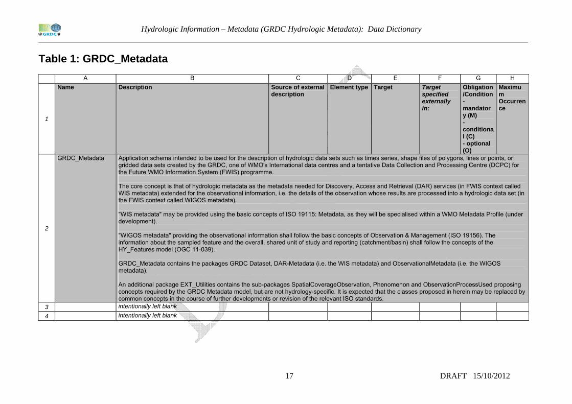
Table 1: GRDC_Metadata
A B C D E F G H
1
Name Description Source of external description
Element type Target Target specified externally in:
Obligation/Condition- mandatory (M) - conditional (C) - optional (O)
Maximum Occurrence
2
GRDC_Metadata Application schema intended to be used for the description of hydrologic data sets such as times series, shape files of polygons, lines or points, or gridded data sets created by the GRDC, one of WMO's International data centres and a tentative Data Collection and Processing Centre (DCPC) for the Future WMO Information System (FWIS) programme. The core concept is that of hydrologic metadata as the metadata needed for Discovery, Access and Retrieval (DAR) services (in FWIS context called WIS metadata) extended for the observational information, i.e. the details of the observation whose results are processed into a hydrologic data set (in the FWIS context called WIGOS metadata). "WIS metadata" may be provided using the basic concepts of ISO 19115: Metadata, as they will be specialised within a WMO Metadata Profile (under development). "WIGOS metadata" providing the observational information shall follow the basic concepts of Observation & Management (ISO 19156). The information about the sampled feature and the overall, shared unit of study and reporting (catchment/basin) shall follow the concepts of the HY_Features model (OGC 11-039). GRDC_Metadata contains the packages GRDC Dataset, DAR-Metadata (i.e. the WIS metadata) and ObservationalMetadata (i.e. the WIGOS metadata). An additional package EXT_Utilities contains the sub-packages SpatialCoverageObservation, Phenomenon and ObservationProcessUsed proposing concepts required by the GRDC Metadata model, but are not hydrology-specific. It is expected that the classes proposed in herein may be replaced by common concepts in the course of further developments or revision of the relevant ISO standards.
3 intentionally left blank 4 intentionally left blank
Hydrologic Information – Metadata (GRDC Hydrologic Metadata): Annex A: Data Dictionary GRDCHydrologic Metadata
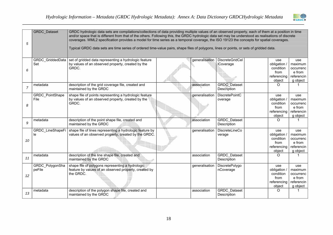
18
5
GRDC_Dataset GRDC hydrologic data sets are compilations/collections of data providing multiple values of an observed property, each of them at a position in time and/or space that is different from that of the others. Following this, the GRDC hydrologic data set may be understood as realisations of discrete coverages. WML2 specification provides a model for time series as a temporal coverage, the ISO 19123 the concepts for spatial coverages. Typical GRDC data sets are time series of ordered time-value pairs, shape files of polygons, lines or points, or sets of gridded data.
6
GRDC_GriddedDataSet
set of gridded data representing a hydrologic feature by values of an observed property, created by the GRDC.
generalisation DiscreteGridCellCoverage
use obligation / condition
from referencing
object
use maximum occurrenc
e from referencing object
7 metadata description of the grid coverage file, created and
maintained by the GRDC association GRDC_Dataset
Description O 1
8
GRDC_PointShapeFile
shape file of points representing a hydrologic feature by values of an observed property, created by the GRDC.
generalisation DiscretePointCoverage
use obligation / condition
from referencing
object
use maximum occurrenc
e from referencing object
9 metadata description of the point shape file, created and
maintained by the GRDC association GRDC_Dataset
Description O 1
10
GRDC_LineShapeFile
shape file of lines representing a hydrologic feature by values of an observed property, created by the GRDC.
generalisation DiscreteLineCoverage
use obligation / condition
from referencing
object
use maximum occurrenc
e from referencing object
11 metadata description of the line shape file, created and
maintained by the GRDC association GRDC_Dataset
Description O 1
12
GRDC_PolygonShapeFile
shape file of polygons representing a hydrologic feature by values of an observed property, created by the GRDC.
generalisation DiscretePolygonCoverage
use obligation / condition
from referencing
object
use maximum occurrenc
e from referencing object
13 metadata description of the polygon shape file, created and
maintained by the GRDC association GRDC_Dataset
Description O 1

Hydrologic Information – Metadata (GRDC Hydrologic Metadata): Data Dictionary
19 DRAFT 15/10/2012
14
GRDC_TimeSeries time series of ordered time-value pairs representing a hydrologic feature by values of an observed property, created by the GRDC.this specialises TimeseriesTVP of the WML2 specification (OGC10-126r3) for additional observational information concerning the feature of interest (--> GRDC_Station), the observed property (--> Hydro_Variable) and the procedure (--> GRDC_DataGenerationProcess).
generalisation TimeseriesTVP WML2 use obligation / condition
from referencing
object
use maximum occurrenc
e from referencing object
15
observation that generated the series of time-value pairs. Note: this association is inherited from generalisation (OM_Observation --> Any [result])
aggregation GRDC_TVPObservation
M 1
16 metadata description of the grid coverage file, created and
maintained by the GRDC association GRDC_Dataset
Description O 1
17 intentionally left blank 18 intentionally left blank
19
DAR-Metadata (WIS Metadata)
This package provides information about the data set needed for Data, Access and Retrieval (DAR) services (so-called WIS metadata). WIS metadata shall use the basic concepts of ISO 19115:Metadata as specialised for the use in the WMO community within a future WMO Metadata Profile (under development). Therefore, the GRDC metadata are defined as specialisation of MD_Metadata without any further specialisation of the inherited relationships. It is expected that the future development of a WMO specific profile of the ISO 19115 standard will provide the framework for the description of GRDC hydrologic data sets and products, particularly regarding the temporal representation of (observation) data such as time series.
Hydrologic Information – Metadata (GRDC Hydrologic Metadata): Annex A: Data Dictionary GRDCHydrologic Metadata
20
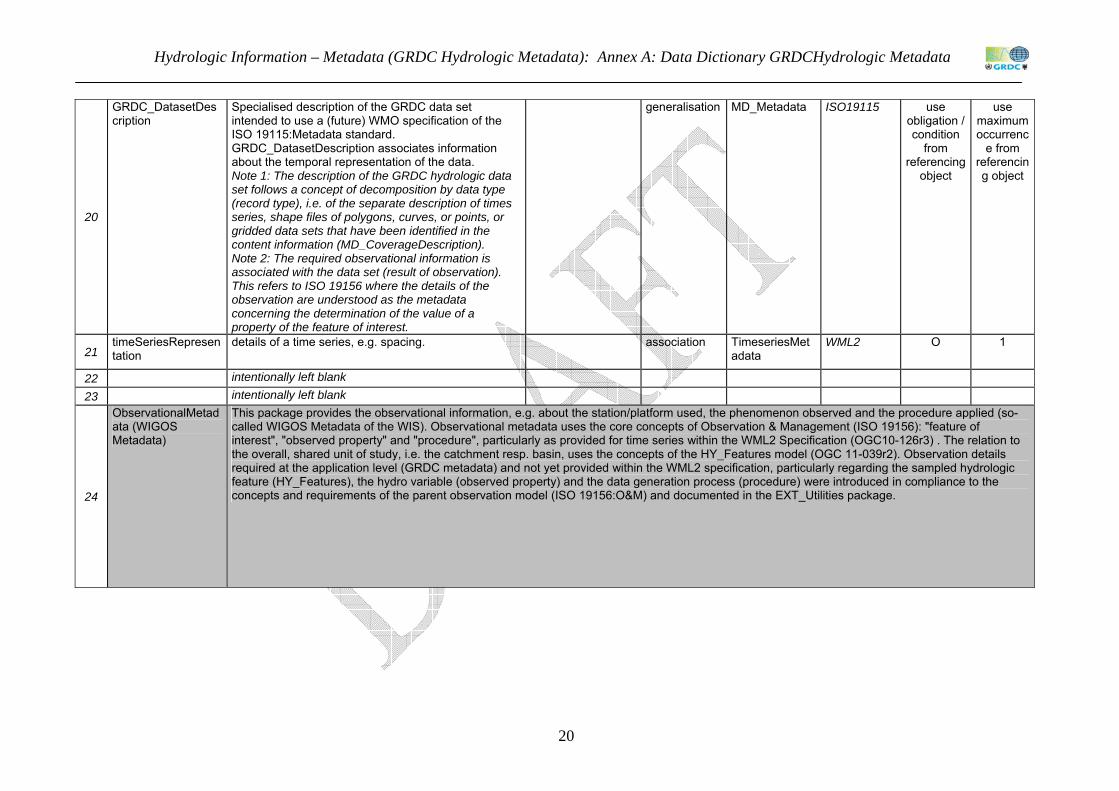
20
GRDC_DatasetDescription
Specialised description of the GRDC data set intended to use a (future) WMO specification of the ISO 19115:Metadata standard. GRDC_DatasetDescription associates information about the temporal representation of the data. Note 1: The description of the GRDC hydrologic data set follows a concept of decomposition by data type (record type), i.e. of the separate description of times series, shape files of polygons, curves, or points, or gridded data sets that have been identified in the content information (MD_CoverageDescription). Note 2: The required observational information is associated with the data set (result of observation). This refers to ISO 19156 where the details of the observation are understood as the metadata concerning the determination of the value of a property of the feature of interest.
generalisation MD_Metadata ISO19115 use obligation / condition
from referencing
object
use maximum occurrenc
e from referencing object
21 timeSeriesRepresentation
details of a time series, e.g. spacing. association TimeseriesMetadata
WML2 O 1
22 intentionally left blank 23 intentionally left blank
24
ObservationalMetadata (WIGOS Metadata)
This package provides the observational information, e.g. about the station/platform used, the phenomenon observed and the procedure applied (so-called WIGOS Metadata of the WIS). Observational metadata uses the core concepts of Observation & Management (ISO 19156): "feature of interest", "observed property" and "procedure", particularly as provided for time series within the WML2 Specification (OGC10-126r3) . The relation to the overall, shared unit of study, i.e. the catchment resp. basin, uses the concepts of the HY_Features model (OGC 11-039r2). Observation details required at the application level (GRDC metadata) and not yet provided within the WML2 specification, particularly regarding the sampled hydrologic feature (HY_Features), the hydro variable (observed property) and the data generation process (procedure) were introduced in compliance to the concepts and requirements of the parent observation model (ISO 19156:O&M) and documented in the EXT_Utilities package.
Hydrologic Information – Metadata (GRDC Hydrologic Metadata): Data Dictionary
21 DRAFT 15/10/2012
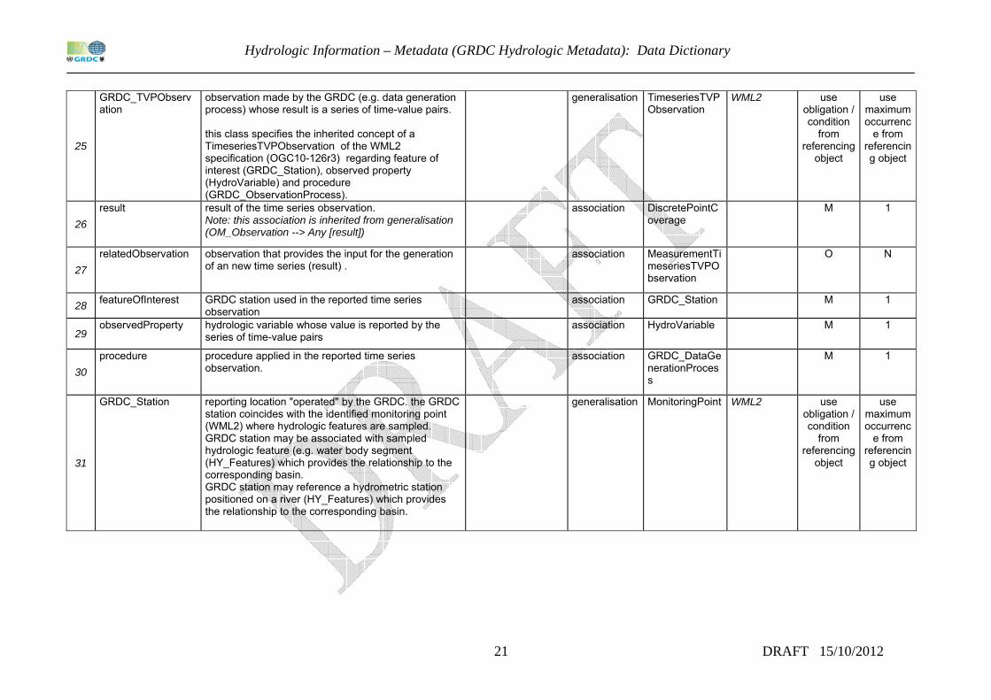
25
GRDC_TVPObservation
observation made by the GRDC (e.g. data generation process) whose result is a series of time-value pairs. this class specifies the inherited concept of a TimeseriesTVPObservation of the WML2 specification (OGC10-126r3) regarding feature of interest (GRDC_Station), observed property (HydroVariable) and procedure (GRDC_ObservationProcess).
generalisation TimeseriesTVPObservation
WML2 use obligation / condition
from referencing
object
use maximum occurrenc
e from referencing object
26 result result of the time series observation.
Note: this association is inherited from generalisation (OM_Observation --> Any [result])
association DiscretePointCoverage
M 1
27 relatedObservation observation that provides the input for the generation
of an new time series (result) . association MeasurementTi
meseriesTVPObservation
O N
28 featureOfInterest GRDC station used in the reported time series observation
association GRDC_Station M 1
29 observedProperty hydrologic variable whose value is reported by the
series of time-value pairs association HydroVariable M 1
30 procedure procedure applied in the reported time series
observation. association GRDC_DataGe
nerationProcess
M 1
31
GRDC_Station reporting location "operated" by the GRDC. the GRDC station coincides with the identified monitoring point (WML2) where hydrologic features are sampled. GRDC station may be associated with sampled hydrologic feature (e.g. water body segment (HY_Features) which provides the relationship to the corresponding basin. GRDC station may reference a hydrometric station positioned on a river (HY_Features) which provides the relationship to the corresponding basin.
generalisation MonitoringPoint WML2 use obligation / condition
from referencing
object
use maximum occurrenc
e from referencing object
Hydrologic Information – Metadata (GRDC Hydrologic Metadata): Annex A: Data Dictionary GRDCHydrologic Metadata
22
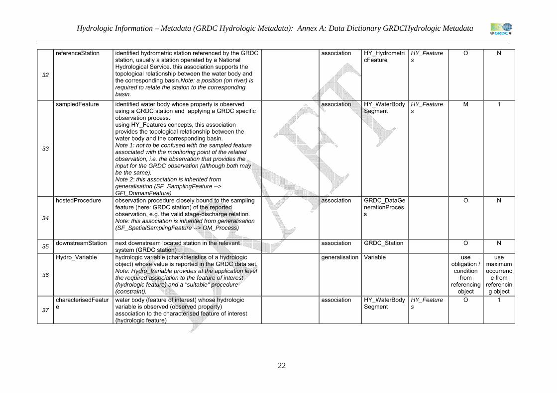
32
referenceStation identified hydrometric station referenced by the GRDC station, usually a station operated by a National Hydrological Service. this association supports the topological relationship between the water body and the corresponding basin.Note: a position (on river) is required to relate the station to the corresponding basin.
association HY_HydrometricFeature
HY_Features
O N
33
sampledFeature identified water body whose property is observed using a GRDC station and applying a GRDC specific observation process. using HY_Features concepts, this association provides the topological relationship between the water body and the corresponding basin. Note 1: not to be confused with the sampled feature associated with the monitoring point of the related observation, i.e. the observation that provides the input for the GRDC observation (although both may be the same). Note 2: this association is inherited from generalisation (SF_SamplingFeature --> GFI_DomainFeature)
association HY_WaterBodySegment
HY_Features
M 1
34
hostedProcedure observation procedure closely bound to the sampling feature (here: GRDC station) of the reported observation, e.g. the valid stage-discharge relation. Note: this association is inherited from generalisation (SF_SpatialSamplingFeature --> OM_Process)
association GRDC_DataGenerationProcess
O N
35 downstreamStation next downstream located station in the relevant system (GRDC station) .
association GRDC_Station O N
36
Hydro_Variable hydrologic variable (characteristics of a hydrologic object) whose value is reported in the GRDC data set. Note: Hydro_Variable provides at the application level the required association to the feature of interest (hydrologic feature) and a "suitable" procedure (constraint).
generalisation Variable use obligation / condition
from referencing
object
use maximum occurrenc
e from referencing object
37
characterisedFeature
water body (feature of interest) whose hydrologic variable is observed (observed property) association to the characterised feature of interest (hydrologic feature)
association HY_WaterBodySegment
HY_Features
O 1
Hydrologic Information – Metadata (GRDC Hydrologic Metadata): Data Dictionary
23 DRAFT 15/10/2012
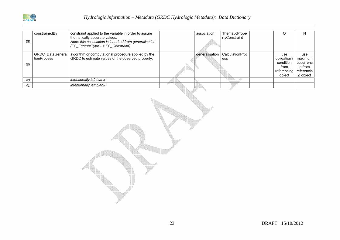
38
constrainedBy constraint applied to the variable in order to assure thematically accurate values. Note: this association is inherited from generalisation (FC_FeatureType --> FC_Constraint)
association ThematicPropertyConstraint
O N
39
GRDC_DataGenerationProcess
algorithm or computational procedure applied by the GRDC to estimate values of the observed property.
generalisation CalculationProcess
use obligation / condition
from referencing
object
use maximum occurrenc
e from referencing object
40 intentionally left blank 41 intentionally left blank
Hydrologic Information – Metadata (GRDC Hydrologic Metadata): Annex A: Data Dictionary GRDCHydrologic Metadata
24
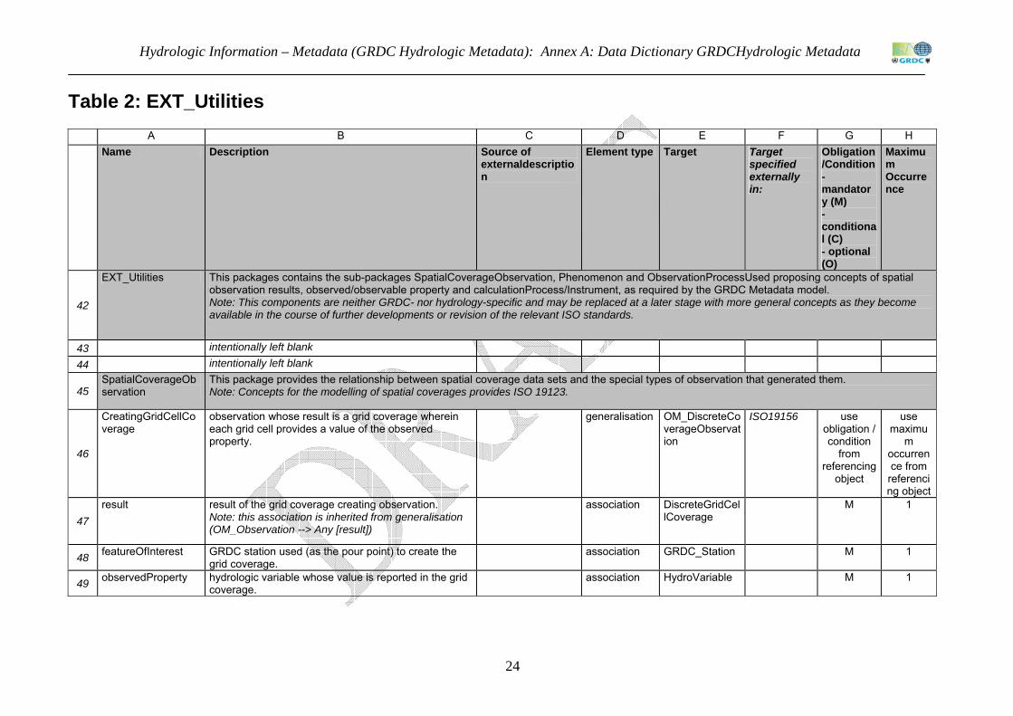
Table 2: EXT_Utilities
A B C D E F G H
Name Description Source of externaldescription
Element type Target Target specified externally in:
Obligation/Condition- mandatory (M) - conditional (C) - optional (O)
Maximum Occurrence
42
EXT_Utilities This packages contains the sub-packages SpatialCoverageObservation, Phenomenon and ObservationProcessUsed proposing concepts of spatial observation results, observed/observable property and calculationProcess/Instrument, as required by the GRDC Metadata model. Note: This components are neither GRDC- nor hydrology-specific and may be replaced at a later stage with more general concepts as they become available in the course of further developments or revision of the relevant ISO standards.
43 intentionally left blank 44 intentionally left blank
45 SpatialCoverageObservation
This package provides the relationship between spatial coverage data sets and the special types of observation that generated them. Note: Concepts for the modelling of spatial coverages provides ISO 19123.
46
CreatingGridCellCoverage
observation whose result is a grid coverage wherein each grid cell provides a value of the observed property.
generalisation OM_DiscreteCoverageObservation
ISO19156 use obligation / condition
from referencing
object
use maximu
m occurrence from
referencing object
47 result result of the grid coverage creating observation.
Note: this association is inherited from generalisation (OM_Observation --> Any [result])
association DiscreteGridCellCoverage
M 1
48 featureOfInterest GRDC station used (as the pour point) to create the grid coverage.
association GRDC_Station M 1
49 observedProperty hydrologic variable whose value is reported in the grid coverage.
association HydroVariable M 1
Hydrologic Information – Metadata (GRDC Hydrologic Metadata): Data Dictionary
25 DRAFT 15/10/2012
50 procedure procedure applied to create the grid coverage. association GRDC_DataGe
nerationProcess
M 1
51
CreatingPointCoverage
observation whose result is a grid coverage wherein each grid cell provides a value of the observed property.
generalisation OM_PointCoverageObservation
ISO19156 use obligation / condition
from referencing
object
use maximu
m occurrence from
referencing object
52 result result of the point coverage creating observation.
Note: this association is inherited from generalisation (OM_Observation --> Any [result])
association DiscretePointCoverage
M 1
53 featureOfInterest GRDC station which is the identified pour point (of the
underlying grid) used to create the point coverage. association GRDC_Station M 1
54 observedProperty hydrologic variable whose value is reported in the point coverage.
association HydroVariable M 1
55 procedure procedure applied to create the point coverage. association GRDC_DataGe
nerationProcess
M 1
56
CreatingLineCoverage
observation whose result is a line coverage wherein each line provides a value of the observed property.
generalisation OM_DiscreteCoverageObservation
ISO19156 use obligation / condition
from referencing
object
use maximu
m occurrence from
referencing object
57 result result of the line coverage creating observation.
Note: this association is inherited from generalisation (OM_Observation --> Any [result])
association DiscretePointCoverage
M 1
58 featureOfInterest GRDC station which is the identified pour point (of the
underlying grid) used to create the line coverage. association GRDC_Station M 1
59 observedProperty hydrologic variable whose value is reported in the line coverage.
association HydroVariable M 1
60 procedure procedure applied to create the line coverage. association GRDC_DataGe
nerationProcess
M 1
Hydrologic Information – Metadata (GRDC Hydrologic Metadata): Annex A: Data Dictionary GRDCHydrologic Metadata
26
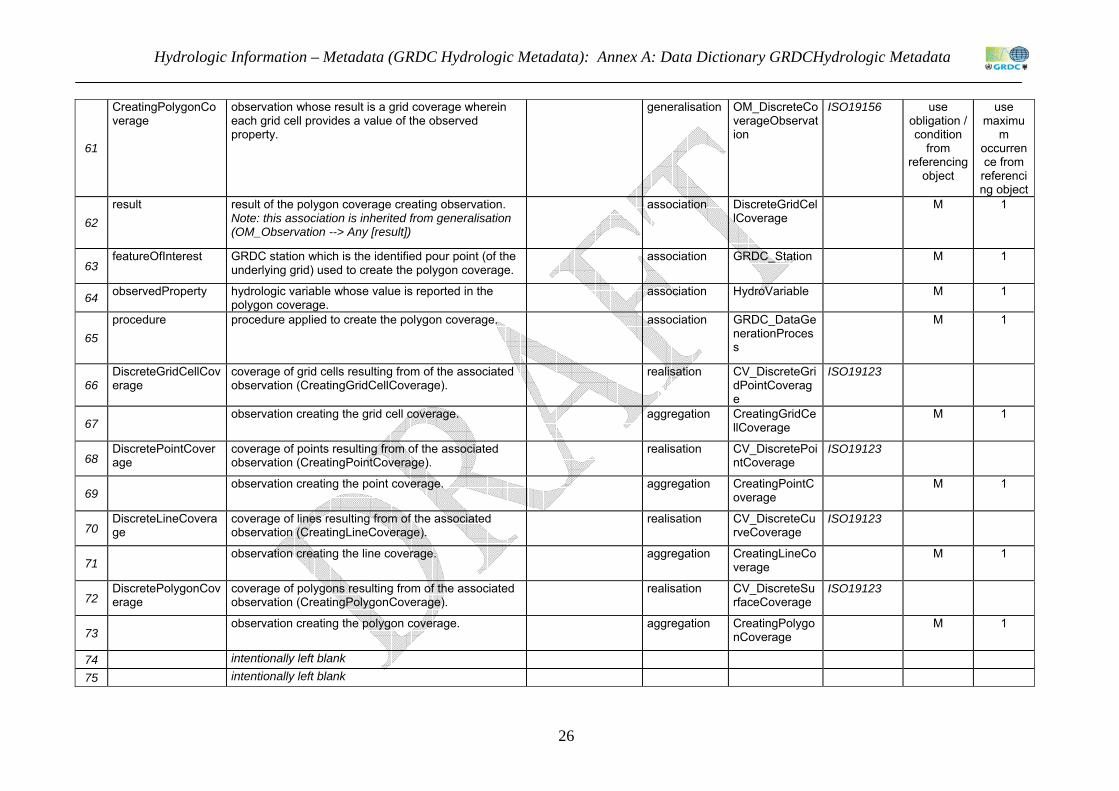
61
CreatingPolygonCoverage
observation whose result is a grid coverage wherein each grid cell provides a value of the observed property.
generalisation OM_DiscreteCoverageObservation
ISO19156 use obligation / condition
from referencing
object
use maximu
m occurrence from
referencing object
62 result result of the polygon coverage creating observation.
Note: this association is inherited from generalisation (OM_Observation --> Any [result])
association DiscreteGridCellCoverage
M 1
63 featureOfInterest GRDC station which is the identified pour point (of the
underlying grid) used to create the polygon coverage. association GRDC_Station M 1
64 observedProperty hydrologic variable whose value is reported in the polygon coverage.
association HydroVariable M 1
65 procedure procedure applied to create the polygon coverage. association GRDC_DataGe
nerationProcess
M 1
66 DiscreteGridCellCoverage
coverage of grid cells resulting from of the associated observation (CreatingGridCellCoverage).
realisation CV_DiscreteGridPointCoverage
ISO19123
67 observation creating the grid cell coverage. aggregation CreatingGridCe
llCoverage M 1
68 DiscretePointCoverage
coverage of points resulting from of the associated observation (CreatingPointCoverage).
realisation CV_DiscretePointCoverage
ISO19123
69 observation creating the point coverage. aggregation CreatingPointC
overage M 1
70 DiscreteLineCoverage
coverage of lines resulting from of the associated observation (CreatingLineCoverage).
realisation CV_DiscreteCurveCoverage
ISO19123
71 observation creating the line coverage. aggregation CreatingLineCo
verage M 1
72 DiscretePolygonCoverage
coverage of polygons resulting from of the associated observation (CreatingPolygonCoverage).
realisation CV_DiscreteSurfaceCoverage
ISO19123
73 observation creating the polygon coverage. aggregation CreatingPolygo
nCoverage M 1
74 intentionally left blank 75 intentionally left blank

Hydrologic Information – Metadata (GRDC Hydrologic Metadata): Data Dictionary
27 DRAFT 15/10/2012
76
ObservationProcessUsed
This package provides specialisation of observation process (defined within WML2). An observation process may be either a sensor or a system of sensors (instrument) using an internal recording procedure, or an algorithm/computational procedure used to calculate the data value. Note: {procedure shall be suitable for observedProperty}: this requirement of the observation model (O&M) needs to be designed at the application level.
77
CalculationProcess algorithm or computational procedure applied to estimate a value of the observed property, based on quantities determined in an (external) observation, or empirical constants.
generalisation ObservationProcess
WML2 use obligation / condition
from referencing
object
use maximu
m occurrence from
referencing object
78 baseQuantity variable determined in an external observation from
which the observed property is derived. attribute Variable O 1
79
Sensor device that responds to a physical or chemical stimulus, used to obtain a value of the observed property. the sensor may be component of a multi-sensor instrument. Note: This type seems equivalent to ISO19130:Sensor Data::SD_Sensor - but is not used because of the reversely directed association with MI_Instrument.
sensor (ISO 772. 5.14). [6]
generalisation (abstract)
ObservationProcess
WML2 use obligation / condition
from referencing
object
use maximu
m occurrence from
referencing object
80 systemOfSensors multi-sensor instrument the sensor is part of. aggregation Instrument O 1
81 encoding algorithm or computational procedure used to convert
the response to a specific code. encoding (ISO 772. 1.129). [6]
association CalculationProcess
O 1
82
Instrument physical instrument, or system of sensors used to obtain a value of the observed property. Note: This type seems equivalent to ISO19115-2(2009):Metadata - Imagery::MI_Instrument - but is not used because of the reversely directed association with SD_Sensor.
generalisation Sensor use obligation / condition
from referencing
object
use maximu
m occurrence from
referencing object
83 intentionally left blank

Hydrologic Information – Metadata (GRDC Hydrologic Metadata): Annex A: Data Dictionary GRDCHydrologic Metadata
28
84
Phenomenon(ObservedObservable)
This package provides fundamental relationships of the observed property which is the abstract notion of an object property in the real-world whose values may be determined by observation. The core concept introduced here is that of a composite observed property (variable), which may be used a proxy for an (ultimate) observable property which is often not known at the date of actual measurement, i.e. at the phenomenon time of the corresponding observation. The determination of the (hydrologic) variable may be constrained by a carrier medium or a procedure. this refers to the requirements of the observation model: " ... property of interest may be indirect, relying on direct observation of a more convenient parameter [i.e. observed property], which is a proxy for the ultimate property of interest [i.e. observable property] ..." (ISO 19156:O&M)
85
ObservableProperty (informative)
This informative package contains fundamental, generally applicable types of object characteristics that may be observed using a sampling feature and applying a procedure. Note 1: FC_FeatureAttribute generalisation provides the required relationships and attributes for an identification using a vocabulary etc. Note 2: the observable property may be a quantity having a magnitude (continuous quantity) or multitude (discrete quantity) whose values can be expressed by a number and reference, but also a nominal property expressed using words, alpha-numeric codes, or Boolean values. depending on application, quantities may be divided into discrete and continuous ones, and further detailed into extensive (with an additive magnitude) and intensive (with non-additive magnitude) ones.
86
ObservableProperty identifiable property carried by the feature (of interest), e.g. a hydrologic domain feature, and ready (fit) to be observed using an appropriate procedure. Note: an observable exists and persists independent of its determination by observation and independent of any possible value that may be determined.
generalisation FC_FeatureAttribute
ISO19110 use obligation / condition
from referencing
object
use maximu
m occurrence from
referencing object
87
nature reference to a fundamental characteristic of the observable property in respect to conformity with a common concept, usually a term in a controlled vocabulary. Examples: natural/naturalised/artificial, normal/normalised, generic/specific, synthetic/analytic, etc.
attribute URI ISO19136 O N
88
NominalProperty property of a phenomenon, body, or substance, where the property has no magnitude, or multitude. such properties usually represent an idea or a logic concept, where the property has a category value that can be expressed by words, alpha-numerical codes etc..
similar to nominal property (VIM3 1.30) [7]
generalisation ObservableProperty
use obligation / condition
from referencing
object
use maximu
m occurrence from
referencing object

Hydrologic Information – Metadata (GRDC Hydrologic Metadata): Data Dictionary
29 DRAFT 15/10/2012
89
Quantity property of a phenomenon, body, or substance, where the property has a magnitude that can be expressed as a number and a reference. a property having a multitude that can be expressed by means of a number and a reference is also considered a quantity. quantities may be specialised into discrete and continuous ones and further into extensive and intensive ones.
quantity (VIM3 1.1) [7]
generalisation ObservableProperty
use obligation / condition
from referencing
object
use maximu
m occurrence from
referencing object
90 quantity reference to the observable quantity, usually a term in
a controlled vocabulary. attribute URI ISO19136 M 1
91
OrdinalQuantity quantity, defined by a conventional measurement procedure, for which a total ordering relation can be established, according to magnitude, with other quantities of the same kind, but for which no algebraic operations among those quantities exist .
ordinal quantity (VIM3 1.26) [7]
generalisation Quantity use obligation / condition
from referencing
object
use maximu
m occurrence from
referencing object
92
DiscreteQuantity quantity representing a multitude created from counting entities, i.e. answering the question "how many?"
generalisation Quantity use obligation / condition
from referencing
object
use maximu
m occurrence from
referencing object
93
ContinuousQuantity quantity representing a magnitude, i.e. answering the question "how much?"
generalisation Quantity use obligation / condition
from referencing
object
use maximu
m occurrence from
referencing object
94
IntensiveQuantity continuous quantity whose magnitude is not additive, i.e. independent of the extent of the system or the amount of the entities inside the system. Examples: temperature, pressure, intensity, density, velocity, viscosity.
generalisation ContinuousQuantity
use obligation / condition
from referencing
object
use maximu
m occurrence from
referencing object

Hydrologic Information – Metadata (GRDC Hydrologic Metadata): Annex A: Data Dictionary GRDCHydrologic Metadata
30
95
ExtensiveQuantity continuous quantity whose magnitude increase/decrease with the extent, i.e. is additive. Examples: volume, mass, thermodynamic temperature. Note 1: the ratio of two extensive quantities is an intensive quantity, e.g. density is mass per volume. Note 2: a percentage is the ratio between quantities of the same dimension, i.e. an intensive quantity. Note 3: the derivative of an extensive quantity is an intensive quantity.
generalisation ContinuousQuantity
use obligation / condition
from referencing
object
use maximu
m occurrence from
referencing object
96 intentionally left blank
97
ObservedProperty This package provides information about the observed property as a composite of other observed properties. Note 1: FC_FeatureAttribute generalisation provides the required relationships and attributes for an identification using a vocabulary etc. Note 2: {observedProperty shall be a phenomenon associated with the feature of interest}: this requirement of the observation model (O&M) needs to be designed at the application level.
98
ObservedProperty the observed property is as a proxy for the "ultimate" (observable) property of interest. according to O&M model: " ... property of interest may be indirect, relying on direct observation of a more convenient parameter [observed property], which is a proxy for the ultimate property of interest [observable] applying an algorithm or process chain." the observedProperty is a composite of 1..* components (variables)
generalisation (abstract)
FC_FeatureAttribute
ISO19110 use obligation / condition
from referencing
object
use maximu
m occurrence from
referencing object
99 variable variable composed of the observed property. aggregation Variable O 1
100 observableProperty object property whose value may be determined using
the observed property. association ObservablePro
perty O N
101
Variable property which may take any value of a specified set of values.
variable (IGH 1331). [1]
generalisation ObservedProperty
use obligation / condition
from referencing
object
use maximu
m occurrence from
referencing object
102 variable reference to the variable, usually a term in a controlled vocabulary.
attribute URI ISO19136 M 1
103 intentionally left blank

Hydrologic Information – Metadata (GRDC Hydrologic Metadata): Data Dictionary
31 DRAFT 15/10/2012
104 ConstrainedProperty
This package provides the description of the material, substance or organism, or the procedure applied to the observed property as a constraint in order to assure thematically accurate property values.
105
ThematicPropertyConstraint
material, substance, organism or procedure that constrains the determination of the property of interest.
generalisation FC_Constraint ISO19110 use obligation / condition
from referencing
object
use maximu
m occurrence from
referencing object
106 material constraint set by the material carrying the property. association Material O 1 107 organism constraint set by the organism carrying the property. association Organism O 1 108 substance constraint set by the substance carrying the property. association Substance O 1
109
procedure constraint set by the procedure to be applied. Note: {procedure shall be suitable for observedProperty}: this requirement of the observation model (O&M) needs to be designed at the application level.
association Procedure O 1
110
Material any body made of matter, e.g. air, water, sediment. material may be a single chemical element, a compound of these or a mixture of those compounds. Note: WML2 recommends that "observed phenomena be separated from the physical medium that is being sampled" (section 9.4.1.8.3)
class
111 material reference to the constraining material, usually a term
in a controlled vocabulary. attribute URI ISO19136 M 1
112 Organism any body or substance that carries activities of life.
organism may be a single cell, a tissue made from cells or an organ made from multiple tissues.
class
113 organism reference to the constraining organism, usually a term
in a controlled vocabulary. attribute URI ISO19136 M 1
114 Substance any form of matter that has constant chemical
composition, that can not be separated into components by physical separation methods.
class
115 substance reference to the constraining substance, usually a
term in a controlled vocabulary. attribute URI ISO19136 M 1
116 Procedure (standard) configuration or algorithm typically applied
for valuation of the property. class

Hydrologic Information – Metadata (GRDC Hydrologic Metadata): Annex A: Data Dictionary GRDCHydrologic Metadata
32
117 procedure reference to the constraining procedure, usually a
term in a controlled vocabulary. attribute URI ISO19136 M 1
118 algorithm (standard) algorithm or process chain typically applied
for property valuation. association CalculationProc
ess O 1
119 configuration (standard) configuration of instruments applied for property valuation.
association Instrument O 1
120 intentionally left blank 121 intentionally left blank
References of column C in Tables 1 and 2: Source of external description
[1] WMO (1992), International glossary of hydrology/Glossaire international d'hydrologie. WMO (Series) ; no. 385., 2nd ed., 1992, Paris ; Geneva : United Nations Educational, Scientific and Cultural Organization ; World Meteorological Organization.
[2] WMO (2008), Guide to hydrological practices. WMO (Series) ; no. 158., 6th ed., 2008, Geneva : World Meteorological Organization. [3] WMO (2006), Technical regulations: Vol.III: Hydrology. WMO (Series) ; no. 49., 2006, Geneva : World Meteorological Organization.
[4] WMO (1992), International meteorological vocabulary/Vocabulaire météorologique international. WMO (Series) ; no. 182., 1992, Geneva : World Meteorological Organization.
[6] ISO (2011), Hydrometry — Vocabulary and symbols. ISO ; 772., 5th ed., 2011, Geneva : ISO.
[7] JCGM (2012), International vocabulary of metrology ― Basic and general concepts and associated terms. JCGM (series) ; 200., 3rd ed., 2012, [Joint Committee for Guides on Metrology].

Hydrologic Information – Metadata (GRDC Hydrologic Metadata): Annex B: HY_Features Data Dictionary
33
ANNEX B: HY_Features Data Dictionary This document provides the Data Dictionary of the HY_Features common hydrologic feature model. It is distributed for review and comment. It will be updated whenever required in course of the further development of the UML model and is subject to change without notice.
The HY_Features model is a conceptual UML model. This data dictionary describes the packages of the model, the relationships between classes and general attributes, their obligation and maximum occurrence.
The data dictionary lists for all elements of HY_Features common hydrologic feature model:
• name of the model component
• description
• source of external description
• element type
• target (of relation)
• source specification of the target (external), e.g. WML2
• obligation/condition (mandatory, conditional, optional)
• maximum occurrence
Each table column is named, each is row numbered.
Tables in Annex B: Table 3: HY_Features (main)................................................................................................... 34 Table 4: HY_HydroGeologicUnit............................................................................................ 35 Table 5: HY_HydroFeature...................................................................................................... 35 Table 6: HY_AtmosphericFeature ........................................................................................... 48 Table 7: HY:SubsurfaceHydroFeature..................................................................................... 50 Table 8: HY_SurfaceHydroFeature ......................................................................................... 53 Table 9: HY_HydrometricNetwork ......................................................................................... 57 Table 10: HY_Utilities ............................................................................................................. 59

Hydrologic Information – Metadata (GRDC Hydrologic Metadata): Annex B: HY_Features Data Dictionary
34
Table 3: HY_Features (main) A B C D E F G H 1 Name Description Source of description
(external) Element Target Target specified
externally in: Obligation/Condition
- mandatory (M) - conditional (C)
- optional (O)
Maximum Occurrence
2 HY_Features The HY_Features model contains a component application schema (modelled according to ISO 19103 Conceptual Schema Language and ISO 19109 General Feature Model) defining semantic models for hydrologic features. These models are managed in sub-domain specific packages, allowing extension to a core set and involvement of relevant expert groups in the governance of individual models. A hydrologic feature is the abstraction of the hydrology phenomenon. Commonly recognised as the abstract unit where hydrologic processes take place, a catchment is considered the abstract hydrologic feature which is multiple represented in the real world. Depending on applications and scales a variety of real-world representations may exist. Note 1: In this context, hydrography refers to the cartographic representation of water bodies, aggregated through a connecting system of drainage channels. The hydrographic survey in the sense of measurement of depth of an open water body is not a concern of HY_Features. Note 2: In this context, the measurement and analysis of water including methods, techniques and instrumentation used in hydrology (hydrometry) is not a concern of HY_Features. Note 3: Whenever an appropriate definition is provided in the “International Glossary of Hydrology”, a joint publication of WMO and UNESCO, the model captures the meaning of relevant features and feature properties as published in the electronic version.
3 intentionally left blank 4 intentionally left blank

Hydrologic Information – Metadata (GRDC Hydrologic Metadata): Annex B: HY_Features Data Dictionary
35 DRAFT 15/10/2012
Table 4: HY_HydroGeologicUnit
A B C D E F G H 1 Name Description Source of
description (external)
Element Target Target specified externally in:
Obligation/Condition
- mandatory (M)
- conditional (C)
- optional (O)
Maximum Occurrence
5 HY_HydroGeologicUnit HY_HydroGeologicUnit provides an overall pattern to describe the geologic conditions taken into account in hydrologic studies, particularly concerning groundwater and soil water
6 HY_HydroGeologicUnit formation or zone of geological material (rock or soil ) with hydrologically significant characteristics.
class use obligation / condition
from referencing
object
use maximum
occurrence from
referencing object
7 containingUnit containing (hosting) hydrogeologic unit in a (nested) hierarchy of units. Note: refers to a simple hierarchy, as typically used for high order organisation of management and reporting units.
association HY_HydroGeologicUnit
O 1
8 HY_HydroGeologicStratum (also HydroStratigraphicUnit)
layer (stratum) of material (rock or soil) dividing a hydrogeologic unit by water bearing characteristics. Note: refers to the vertical stratification within the hydrogeologic unit.
class use obligation / condition
from referencing
object
use maximum
occurrence from
referencing object
9 hydroGeologicUnit hydrogeologic unit the stratum (layer) is part of. aggregation
HY_HydroGeologicUnit
M 1
10 intentionally left blank 11 intentionally left blank
Table 5: HY_HydroFeature
A B C D E F G H

Hydrologic Information – Metadata (GRDC Hydrologic Metadata): Annex B: HY_Features Data Dictionary
36
1 Name Description Source of description (external)
Element Target Target specified externally in:
Obligation/Condition
- mandatory
(M) -
conditional (C)
- optional (O)
Maximum
Occurrence
12 HY_HydroFeature HY_HydroFeature schema defines fundamental properties and relationships between features governed by the physical laws of hydrology. The core concept introduced here is that a study of hydrology will reflect common concepts of the real world by specific modelled features (as per ISO 19019 General Feature Model). Depending on the scientific concern, the relevant hydrologic feature may represent different aspects of the hydrology phenomenon, typically catchment or basin area, watershed (boundary), flowlines and connectivity (network). Each hydrologic feature may be considered capable to store and yield water independent of its network connectivity.
13 intentionally left blank 14 HY_NamedFeature HY_NamedFeature provides an abstract pattern shared by all hydrologic features where names are given to a feature, through common usage, without
necessarily have a formal model. These named features are further elucidated in different concrete feature types which specify the properties each representation uses to define one or more aspects of the hydrology of a feature.
15 HY_HydroFeature abstract notion of the hydrology phenomenon. depending on application and scale, hydrologic features may be multiple and differently represented in the real world. Note: refers to waters above, on and below the land surfaces of the Earth, whose occurrence, circulation and distribution in time and space, whose biological, chemical and physical properties, and whose reaction with the environment is object of scientific interest.
according to hydrology (IGH 0623). [1]
class use obligation / condition
from referencing
object
use maximum occurrenc
e from referencing object
16 identifier external identifier of the feature. attribute EXT_IdentificationCode
O N
17 name name taking cultural, political or historical context into account.
association HY_HydroFeatureName
O N
18 context characteristics assigned to the hydrologic feature in a spatial, temporal or classification context.
association HY_FeatureContext
O N
19 HY_FeatureContext generally applicable characteristics assigned to the hydrologic feature in a spatial, temporal or classification context.
class use obligation / condition
from
use maximum occurrenc
e from

Hydrologic Information – Metadata (GRDC Hydrologic Metadata): Annex B: HY_Features Data Dictionary
37 DRAFT 15/10/2012
referencing object
referencing object
20 temporalContext existence or behaviour in time. association EXT_TemporalContext
O N
21 spatialContext interaction with an external spatial feature. association EXT_SpatialContext
O N
22 classificationContext position or rank in a system of ordering or classification system.
association EXT_ClassificationContext
O N
23 hydroFeature carrier of the characteristic property. association HY_HydroFeature
O 1
24 HY_HydroFeatureName
localised name for all or part of a hydrologic feature. generalisation EXT_LocalisedName
use obligation / condition
from referencing
object
use maximum occurrenc
e from referencing object
25 namesPart identifier, whether the name applies to a part of feature only or not.
attribute Boolean ISO 19103 O 1
26 preferredBy specifies that this name is the preferred name according to the named entity.
attribute CI_ResponsibleParty
ISO 19115 O 1
27 source source of the name identifying its origin. attribute CI_Citation ISO 19115 O 1 28 variantSpelling identifier, whether the name is a variant spelling or not.
False = preferred name in specified language. attribute Boolean ISO 19103 O 1
29 intentionally left blank 30 HY_Catchment HY_Catchment defines a logical network of catchments.
Each catchment may be represented in any hydrologically meaningful sub-domain model, including by a stream network, or a nested network of catchments. HY_Catchment provides the topological concept to consider an arbitrary point on, or projected onto, the land surface as the outfall of a corresponding basin. Positioned in the hydrographic network, this point provides the identifiable reference point to which alternative representations may refer. The catchment model allows for the existence of catchments to be recognised, and identifiers assigned based on outflow nodes even if stream networks and watersheds and areas are not reliably determined. The catchment model is sufficient for the case of simplified hierarchies of basins to be defined. It is intended that hydrological reporting applications may use this model without the full complexity of surface water hydrology feature models. The catchment model provides for a logical network, without unnecessary detail of stream flow, cartographic interpretation and varying conditions. This is sufficient to allow the topological relationships between hydrometric stations to be established.

Hydrologic Information – Metadata (GRDC Hydrologic Metadata): Annex B: HY_Features Data Dictionary
38
31 HY_Catchment basic unit where hydrologic processes take place. catchment is commonly recognised as the basic unit of study, management or reporting in hydrology.
generalisation HY_HydroFeature
use obligation / condition
from referencing
object
use maximum occurrenc
e from referencing object
32 HY_CatchmentRepresentation
representation of a catchment, typically by an area, a boundary line, or a network structure.
class (abstract)
O N
33 representedCatchment
catchment represented by area, boundary line, network, etc.
association HY_Catchment M 1
34 HY_CatchmentArea delineated surface area representing a catchment. Examples concerning basin may be drainage, recharge or discharge area. Note: allows a simple polygon representation of a catchment .
generalisation HY_CatchmentRepresentation
use obligation / condition
from referencing
object
use maximum occurrenc
e from referencing object
35 area area expressing the extent of the catchment. attribute Area ISO 19103 O 1 36 shape shape expressing the geometry of the catchment. attribute GM_Surface 10107 O 1 37 HY_CatchmentBoun
dary delineated boundary (line) representing a catchment. Example: watershed representing a basin.
generalisation HY_CatchmentRepresentation
use obligation / condition
from referencing
object
use maximum occurrenc
e from referencing object
38 boundary closed line bounding the surface of the catchment . attribute GM_SurfaceBoundary
ISO 19107 M 1
39 HY_Basin special catchment whose waters, surface and subsurface waters, are flowing to a common outlet, caused either by gravity or by pumping. Note 1:the concept refers to the continuous interaction of surface and subsurface waters within the hydrologic cycle. depending on application and scale a differentiation into drainage basin or groundwater basin is with the relevant representation. Note 2: this concept requires a stable identifier that is not merely a function of an arbitrary delineation of the surface, and secondly that basins are delineated within a simple hierarchy (tree structure). More complex structures can be described as representations using "network" representation pattern.
according to drainage basin (IGH 0360) and groundwaterbasin (IGH 0552). [1]
generalisation HY_Catchment use obligation / condition
from referencing
object
use maximum occurrenc
e from referencing object
40 code unique identifier of a basin in a classification or coding attribute ScopedName ISO 19103 O 1

Hydrologic Information – Metadata (GRDC Hydrologic Metadata): Annex B: HY_Features Data Dictionary
39 DRAFT 15/10/2012
system. 41 containingBasin containing basin in a nested hierarchy of basins.
Note 1: refers to simple hierarchy of basins, as typically used for high order organisation of management and reporting units. Note 2: topological hierarchies may be determined through the relationships between HY_Outfall nodes within a hierarchy.
association HY_Basin O 1
42 pointOfOutflow point where water flows out of a stream, lake, reservoir, container, basin, aquifer system, etc.
according to outflow (IGH 0867). [1]
association HY_Outfall M 1
43 pointOfOInflow point where water flows into a stream, lake, reservoir, container, basin, aquifer system, etc.
according to inflow (IGH 0672). [1]
association HY_Outfall O 1
44 containingSystem all comprising system (highest level hierarchy) containing a network of basins .
aggregation HY_BasinHierarchy
O 1
45 HY_BasinHierarchy highest level hierarchy containing the network of basins, a set of discrete upper-level systems that are hydrologically discrete. Typically, this will be a river system flowing into a sea or an internal sink.
generalisation HY_Network use obligation / condition
from referencing
object
use maximum occurrenc
e from referencing object
46 HY_Network network structure (topology) representing a catchment. Example: hydrographic network representing a basin. Note: network refers to the linkage of features using a connecting system like a channel network (drainage pattern) or a system of connected aquifers.
generalisation HY_CatchmentRepresentation; HY_HydroFeature
use obligation / condition
from referencing
object
use maximum occurrenc
e from referencing object
47 HY_Outfall topological concept that considers each point on the land surface as the outfall of a corresponding basin. Note 1: Outfall represents a logic point and may not have an explicit location. This may be a fixed landmark, a station, or the point where groundwater enters the surface, but also a point projected onto the surface or created from collapsing other points. Example: vertically arranged points may be aggregated and projected onto surface. a delta of a river system may be logically aggregated to a point located at the mouth. Note 2: For waters flowing due to gravitational forces the outfall coincides with the lowest point on the summit line bounding the corresponding basin.
class use obligation / condition
from referencing
object
use maximum occurrenc
e from referencing object

Hydrologic Information – Metadata (GRDC Hydrologic Metadata): Annex B: HY_Features Data Dictionary
40
48 contributingBasin basin which contributes water over the point of outflow. identifies the basin defined by the outflow point.
association HY_Basin M N
49 receivingBasin basin which receives water over the point of inflow, e. g. from upstream basin/s. identifies the basin defined by the inflow point.
association HY_Basin O N
50 position position of outfall in the hydrographic network. Position refers to a fixed landmark referenced by coordinates.
association HY_IndirectPosition
M 1
51 HY_ReferencePoint landmark fixed and referenced by coordinates. according to station description (GHP, 2.5.2) [2]
class use obligation / condition
from referencing
object
use maximum occurrenc
e from referencing object
52 refPoint accepted location of a reference point, given that a single point may have several reported locations depending on its nature and the precision of measurement. Note: The reference point is the basis for which linear measures within a network may be determined.
attribute GM_Point ISO 19107 O 1
53 refPointType term from a codelist identifying the reference point by type.
attribute HY_RefPointType
O 1
54 networkLocation location of reference point in the related network of basins. Note: According to the concept of catchment, the a reference point is outfall of a corresponding basin.
association HY_Outfall O 1
55 HY_RefPointType term identifying a fixed landmark determined as reference point. Source: station description. (2008). In: WMO Guide to Hydrological Practices. 6th ed. (2008). Chapter 2.5.2: Station identification. WMO; 168
codelist
56 barrage barrier across a stream provided with a series of gates or other control mechanisms to control the water-surface level upstream, to regulate the flow or to divert water supplies into a canal.
barrage (IGH 0110). [1]
codelist item 1
57 bifurcation division of a stream into two branches. bifurcation (IGH 0131). [1]
codelist item 1
58 confluence joining, or the place of junction, of two or more streams.
confluence (IGH 0235). [1]
codelist item 1
59 dam barrier constructed across a valley for impounding water or creating a reservoir.
dam.(IGH 0285). [1] codelist item 1

Hydrologic Information – Metadata (GRDC Hydrologic Metadata): Annex B: HY_Features Data Dictionary
41 DRAFT 15/10/2012
60 hydrometricStation station at which data on water in rivers, lakes or reservoirs are obtained on one or more of the following elements: stage, streamflow, sediment transport and deposition, water temperature and other physical properties of water, characteristics of ice cover and chemical properties of water.
hydrometric station.(IGH 0627). [1]
codelist item 1
61 diversionOfWater transfer of water from one watercourse to another, such watercourses being either natural or man-made.
diversion of water.(IGH 0349). [1]
codelist item 1
62 fork (1) Place where two or more streams flow together to form a larger stream. (2) Place where a stream divides into two or more streams.
fork (IGH 0499). [1] codelist item 1
63 inlet structure admitting water supplies from the source or through an intake structure built upstream.
inlet (IGH 0679). [1] codelist item 1
64 intake structure or site, the purpose of which is to control, regulate, divert, and admit water directly from the source, through an inlet built upstream.
intake (IGH 0684). [1]
codelist item 1
65 outlet opening through which water flows out or is extracted from a reservoir or stream.
outlet (IGH 0868). [1]
codelist item 1
66 ponor hole or opening in the bottom or side of a depression where a surface stream or lake flows either partially or completely underground into a karst groundwater system.
ponor (IGH 0925). [1]
codelist item 1
67 rapids reach of a stream where the flow is very swift and shooting, and where the surface is usually broken by obstructions, but has no actual waterfall or cascade.
rapids (IGH 0980). [1]
codelist item 1
68 referenceClimatologicalStation
climatological station the data of which are intended for the purpose of determining climatic trends. This requires long periods (not less than thirty years) of homogeneous records, where man-made environmental changes have been and/or are expected to remain at a minimum. Ideally the records should be of sufficient length to enable the identification of secular changes of climate.
reference climatological station (IGH 0998). [1]
codelist item 1
69 riverMouth place of discharge of a river into a sea or a lake. river mouth (IGH 1043). [1]
codelist item 1
70 sinkhole place where water disappears underground in a limestone region. It generally implies water loss in a closed depression or blind valley.
sinkhole (IGH 1116). [1]
codelist item 1

Hydrologic Information – Metadata (GRDC Hydrologic Metadata): Annex B: HY_Features Data Dictionary
42
71 source origin of river. source (IGH 1166). [1]
codelist item 1
72 spring place where water flows naturally from a rock or soil onto land or into a body of surface water.
spring (IGH 1185). [1]
codelist item 1
73 waterfall vertical fall or the very steep descent of a stream of water.
waterfall (IGH 1365). [1]
codelist item 1
74 weir overflow structure which may be used for controlling upstream water level or for measuring discharge or for both.
weir (IGH 1396). [1] codelist item 1
75 any any other fixed landmark used as accepted reference point.
codelist item N
76 HY_Watershed summit or boundary line separating adjacent drainage basins.
watershed (IGH 0350). [1]
generalisation HY_CatchmentBoundary
C/ HY_CatchmentRepresentation.representedCatchment:HY_Basin
1
77 outfall lowest point on the summit or boundary line of the basin.
according to outfall (IGH 0866). [1]
association HY_Outfall O 1
78 intentionally left blank 79 HY_HydrographicNe
twork The HY_HydrographicNetwork schema provides for topological relationships to be declared between the major elements of the hydrosphere, including segmentation of a watercourse. The HydrographicNetwork introduces concepts of segmentation of hydrographic features and cartographic representations of segments, which may or may not be topologically connected at the representational level. Note: The HydrographicNetwork is defined in the context of a higher order identification of the network each element participates, hence the dependency on the abstract catchment model.
80 HY_DrainagePattern
terms describing the arrangement of drainage lines. codelist
81 annular main rivers have circular pattern with subsidiary channels at right angels.
basic drainage patterns (table 10.4) [5].
codelist item 1
82 centripetal streams flow inward to centre. basic drainage patterns (table 10.4) [5].
codelist item 1
83 dendritic spreading treelike arrangement; no evident orientation of channels (random orientation).
basic drainage patterns (table 10.4) [5].
codelist item 1

Hydrologic Information – Metadata (GRDC Hydrologic Metadata): Annex B: HY_Features Data Dictionary
43 DRAFT 15/10/2012
84 distributary one main channel divides into many anastomozing channelways ending with many outlets.
basic drainage patterns (table 10.4) [5].
codelist item 1
85 parallel main channels regularly spaced and parallel or subparallel to each other; tributaries join at very acute angels.
basic drainage patterns (table 10.4) [5].
codelist item 1
86 pinnate featherlike, closely grouped , short tributaries (fine texture).
basic drainage patterns (table 10.4) [5].
codelist item 1
87 radial streams flow outward from centre. basic drainage patterns (table 10.4) [5].
codelist item 1
88 rectangular drainage forms a perpendicular net with the two directions equally developed.
basic drainage patterns (table 10.4) [5].
codelist item 1
89 trellis a dominant drainage direction with a secondary direction perpendicular to this; primary tributaries join main stream at right angles, secondary tributaries parallel main stem.
basic drainage patterns (table 10.4) [5].
codelist item 1
90 HY_HydrographicNetwork
aggregate of rivers and other permanent or temporary watercourses, and also lakes and reservoirs, over any given area. Note: not to be confused with the hydrometric network of hydrological stations and observing posts.
hydrographic network (IGH 0616). [1]
generalisation HY_Network C / HY_CatchmentRepresentation.representedCatchment:HY_Basin
use maximum occurrenc
e from referencing object
91 drainagePattern arrangement of natural or man-made drainage channels within an area.
drainage pattern (IGH 0363). [1]
attribute HY_DrainagePattern
O 1

Hydrologic Information – Metadata (GRDC Hydrologic Metadata): Annex B: HY_Features Data Dictionary
44
92 HY_WaterBody mass of water distinct from other masses of water. Note 1: refers to real-world objects above, on and below the land surface, or a fiction of these. Note 2: water bodies have names within common experience, but different names in different contexts. Note 3: shape and extent of a (liquid) water body are determined by the properties of the containing object, i.e. the occupied landform, the hosting hydrogeologic unit, manmade container, etc. Note 4: shape and extent of a (liquid) open water body are bound to atmospheric pressure exerted on its surface. lakes and rivers levels are tuned to the surrounding water table. Note 5: in the context of observation the water body is the intended object of observation, i.e. sampled feature.
water body (IGH 1356). [1]
generalisation HY_HydroFeature
use obligation / condition
from referencing
object
use maximum occurrenc
e from referencing object
93 overallArea area of the overall surface of the water body. attribute Area ISO 19103 O 1 94 totalLength length of the (entire)w water body, expressed as
distance from the origin to the base level location. attribute Length ISO 19103 O 1
95 waterBodyName name of the water body usually given in cultural, political and historical contexts. Note: water body and water body segments may have different names.
attribute HY_HydroFeatureName
O N
96 hydrographicNetwork
hydrographic network the water body is part of aggregation HY_HydrographicNetwork
M 1
97 HY_WaterBodySegment
segment of a water body (mass of water). generalisation HY_HydroFeature
use obligation / condition
from referencing
object
use maximum occurrenc
e from referencing object
98 length length of the water body segment, expressed as distance from the origin to the base level location.
attribute Length ISO 19103 O 1
99 surfaceArea area of the surface of the water body segment. attribute Area ISO 19103 O 1 100 waterBodySegment
Name names a part of the water body, usually given in cultural, political and historical contexts. Note: water body and water body segments may have different names.
attribute HY_HydroFeatureName
M N
101 waterBody water body the segment is part of. aggregation HY_WaterBody M 1

Hydrologic Information – Metadata (GRDC Hydrologic Metadata): Annex B: HY_Features Data Dictionary
45 DRAFT 15/10/2012
102 upstreamSegment upstream neighbour segment connected to the relevant feature segment. Note: refers to a simple upstream/downstream relation of two neighbouring parts.
association HY_WaterBodySegment
O N
103 downstreamSegment
downstream neighbour segment connected to the relevant feature segment. Note: refers to a simple upstream/downstream relation of two neighbouring segments of the same geometry.
association HY_WaterBodySegment
O N
104 storage storage of water in surface or underground reservoirs. Note: reservoir refers to the body of water, that is placed, left or managed in a container for future use.
similar to storage (IGH 1215). [1]
association HY_Reservoir O N
105 upstreamReferencePoint
reference point located on the related hydrographic feature in the upstream direction.
association HY_ReferencePoint
O N
106 downstreamReferencePoint
reference point located on the related hydrographic feature in the downstream direction.
association HY_ReferencePoint
M N
107 HY_WaterBodyStratum
distinct layer within a (stratified) body of water. Note: refers to the vertical stratification within the water body by differences in thermal (thermocline) or salinity (halocline) characteristics or by oxygen or nutrient content (e.g. chemocline).
class use obligation / condition
from referencing
object
use maximum occurrenc
e from referencing object
108 stratumType term from a controlled vocabulary expressing the type of the stratum (layer).
according to stratification (IGH 1225) [1]
attribute URI ISO 19103 O N
109 waterBodySegment water body segment the stratum (layer) is part of. aggregation HY_WaterBodySegment
M 1
110 intentionally left blank 111 HY_Storage HY_Storage provides an abstract pattern to describe the storage of water in surface or underground reservoirs, independent of its network connectivity.
This allows networks to be described without details of storage capacities, and storages to be referenced independently of their representation within a network. Note: storage refers to a water body, that is placed, left or managed in a containing unit for future use.
112 HY_Reservoir body of water, either natural or man-made, used for storage, regulation and control of water resources. Note 1: special concepts of surface or underground reservoirs may be defined by application. Note 2: do not confuse an underground reservoir with groundwater reservoir, which refers to the containing aquifer.
reservoir (IGH 1011). [1]
class (abstract)
use obligation / condition
from referencing
object
use maximum occurrenc
e from referencing object

Hydrologic Information – Metadata (GRDC Hydrologic Metadata): Annex B: HY_Features Data Dictionary
46
113 intentionally left blank 114 HY_RiverPositioning
System The HY_RiverPositioningSystem schema provides a means to reference positions on a hydrographic feature via its topology and geometry. The HY_RiverPositioningSystem introduces the concept of indirect position where each location on the land surface may be described relative to or as a distance to a reference point located in a hydrographic network on a hydrographic feature. This concept is suitable to locate an arbitrary hydrometric station depending on its location on a hydrographic feature without having local coordinates. The reference point is identified by coordinates and may be a fixed landmark, but also a physical artefact. According to the catchment concept each reference point is the outfall of a corresponding catchment.
115 HY_IndirectPosition indirect position of a point feature, either expressed as the distance to a reference point or as position relative to reference point or distance.
class use obligation / condition
from referencing
object
use maximum occurrenc
e from referencing object
116 distanceToRefPoint distance to the identified reference point. In case of a direct position (when coordinates are known) the distance to the reference point equals to 0.00.
attribute HY_DistanceToRefPoint
O 1
117 relativePosition position relative to the identified reference point. attribute HY_RelativePosition
O 1
118 mileageCS linear coordinate system used. association HY_MileageCS O 1 119 referencePoint landmark fixed and referenced by coordinates. association HY_Reference
Point M N
120 HY_DistanceToRefPoint
distance to a reference point including indication of accuracy (closeness to the true value) and precision (smallest unit of measurement) . Note: Accuracy has to do with quality of measurement, precision has to do with the resolution of the reported measurement.
accuracy of hydrological measurements (GHP, 2.3.3) [2]
class use obligation / condition
from referencing
object
use maximum occurrenc
e from referencing object
121 accuracyStatement statement whether the distance value agrees with the value accepted as being true. (statement in the sense of exact, greater than or less than the value accepted as being true) . Note: This statement assumes that all known corrections have been applied.
accuracy of hydrological measurements (GHP, 2.3.3) [2]
attribute DQ_RelativeInternalPositionalAccuracy
ISO 19157 (draft)
O 1
122 distanceValue distance value expressed as length, incl. unit of lenght applied.
attribute Length ISO 19103 M 1

Hydrologic Information – Metadata (GRDC Hydrologic Metadata): Annex B: HY_Features Data Dictionary
47 DRAFT 15/10/2012
123 precisionStatement statement on the smallest unit of division on the scale of measurement.
accuracy of hydrological measurements (GHP, 2.3.3) [2]
attribute Distance ISO 19103 O 1
124 HY_RelativePosition relative position, expressed as percentage of the total distance to the reference point, or as a verbal description of the spatial relationship to a reference point.
class use obligation / condition
from referencing
object
use maximum occurrenc
e from referencing object
125 description verbal description of the spatial relationship to the reference point.
attribute HY_RelativePositionDescription
O 1
126 percentage positive value, expressing a percentage of the total distance to the reference point.
attribute Real ISO 19103 O 1
127 HY_MileageCS linear coordinate system used to represent arbitrary water observation points along a stream. origin of the CS is position of the relevant point feature. coordinates are provided as distance (length) upstream or downstream from this origin (e.g. water monitoring point) to a reference point . Note: This type should use ISO19111::Referencing by coordinates::CS_LinearCS, but must be complemented by information about the precision (resolution) of the axis applied for mileage.
generalisation CS_LinearCS ISO 19111 use obligation / condition
from referencing
object
use maximum occurrenc
e from referencing object
128 axis upstream or downstream directed axis. association HY_MileageSystemAxis
M N
129 HY_MileageSystemAxis
axis of the mileage system applied. Note: This type should use ISO19111::Referencing by coordinates::CS_CoordinateSystemAxis, but must be complemented by information about the precision (resolution) of the axis applied for mileage.
generalisation CS_CoordinateSystemAxis
ISO 19111 use obligation / condition
from referencing
object
use maximum occurrenc
e from referencing object
130 precision smallest unit of division on the mileage system axis. accuracy of
hydrological measurements (GHP, 2.3.3) [2]
attribute Distance ISO 19103 O 1

Hydrologic Information – Metadata (GRDC Hydrologic Metadata): Annex B: HY_Features Data Dictionary
48
131 HY_RelativePositionDescription
list of general terms commonly used in hydrology to describe a spatial relation between two points.
codelist
132 at located at the (reference) point codelist item 1 133 between located between two (reference) points codelist item 1 134 downstream located downstream of the (reference) point, e.g. in the
direction of the current in a river or stream. codelist item 1
135 left located left-hand of the (reference) point when facing downstream.
codelist item 1
136 nearby located in a short distance to the (reference) point. codelist item 1 137 rigth located right-hand of the (reference) point when facing
downstream. codelist item 1
138 upstream located upstream of the (reference) point, e.g. in the direction towards the source of a stream.
codelist item 1
139 any any other spatial relation between points not determined.
codelist item
140 intentionally left blank 141 intentionally left blank
Table 6: HY_AtmosphericFeature
1 Name Description Source of description (external)
Element Target Target specified externally in:
Obligation/Condition
- mandator
y (M) -
conditional (C)
- optional (O)
Maximum
Occurrence

Hydrologic Information – Metadata (GRDC Hydrologic Metadata): Annex B: HY_Features Data Dictionary
49 DRAFT 15/10/2012
142 HY_AtmosphericHydroFeature
This ApplicationSchema defines concepts of the hydrology phenomenon above the land surface. Note 1:informative, i.e. concepts may be realised with an identified entity. Note 2: Considering the water falling through the atmosphere the main source of freshwater accumulated on and below the land surface, only precipitation is considered so far. Special concepts of water suspended in the atmosphere may by defined by application.
143 HY_HydroMeteor meteor consisting of an ensemble of liquid or solid water particles falling through or suspended in the atmosphere, blown by the wind from the Earth’s surface or deposited on objects on the ground or in the free air. Note: may be specialised to different types of hydrometeors, e.g. precipitation.
hydrometeor (IMV H0970). [4]
class use obligation / condition
from referencing object
use maximum occurrenc
e from referencing object
144 HY_Precipitation hydrometeor consisting of a fall of an ensemble of particles. Note 1: may be specialised to different forms of precipitation such as rain, drizzle, snow, snow grains, snow pellets, diamond dust, hail and ice pellets. Note 2: not to be confused with the amount of precipitation measured by means of raingauge, which is a property (rainfall).
precipitation (IMV P1360). [4]
generalisation HY_HydroMeteor
use obligation / condition
from referencing object
use maximum occurrenc
e from referencing object
145 accumulatingWaterBody
water body accumulating water from precipitation. association HY_WaterBodySegment
O N
146 bearingAquifer aquifer bearing water from precipitation. association HY_Aquifer O N 147 intentionally left blank 148 intentionally left blank

Hydrologic Information – Metadata (GRDC Hydrologic Metadata): Annex B: HY_Features Data Dictionary
50
Table 7: HY:SubsurfaceHydroFeature
A B C D E F G H 1 Name Description Source of
description (external)
Element Target Target specified externally in:
Obligation/Condition
- mandatory (M)
- conditional (C)
- optional (O)
Maximum
Occurrence
149 HY_SubsurfaceHydroFeature
This ApplicationSchema contains concepts of the hydrology phenomenon below the land surface taking into account the geological conditions. Note 1: informative, i.e. this concepts may be realised with an identified entity. Note 2: Considering water occupying a formation of rock or soil, water accumulated below the land surface is considered as water body confined by these. Special concepts of geologic confines may be defined by application.
150 HY_RechargeArea area representing the hydrogeologic unit which contributes water to an aquifer, either by direct infiltration or by runoff and subsequent infiltration.
according to recharge area (IGH 0685). [1]
generalisation HY_CatchmentArea
use obligation / condition
from referencing
object
use maximum occurrence from
referencing object
151 HY_DischargeArea area representing the hydrogeologic unit where water is extracted (discharged) from an aquifer, either by processes of evapotranspiration, interflow or extraction.
similar to recharge area (IGH 0685). [1]
generalisation HY_CatchmentArea
use obligation / condition
from referencing
object
use maximum occurrence from
referencing object
152 HY_GroundwaterBasin
physiographic unit whose waters are flowing throughout a system of connected or interrelated aquifers to a common outlet.
according to groundwater basin (IGH 0552). [1]
generalisation HY_Basin use obligation / condition
from referencing
object
use maximum occurrence from
referencing object
153 HY_GroundwaterBody
mass of groundwater distinct of other masses of water.Note: groundwater refers to water occupying the saturated zone.
similar to water body (IGH 1356). [1]
generalisation HY_WaterBody use obligation / condition
from referencing
object
use maximum occurrence from
referencing object

Hydrologic Information – Metadata (GRDC Hydrologic Metadata): Annex B: HY_Features Data Dictionary
51 DRAFT 15/10/2012
154 groundwaterReservoir
permeable water-bearing formation capable of yielding exploitable quantities of groundwater.
similar to groundwater reservoir (IGH 0064). [1]
association HY_Aquifer O N
155 intentionally left blank 156 HY_SubsurfaceWat
er concepts of water accumulated in water bodies below the Earth's surface incl. their interaction with surface water bodies. subsurface water may by specialised by pressure head and the property to move due to gravity and capillary action.
157 HY_SubsurfaceWater
water accumulated below the land surface. It needs to be specialised into water occupying either the satured zone (groundwater) or the unsaturated zone (vadose water). Note: not to be confused with a body of subsurface water occupying a formation or zone of geologic material, e.g. aquifer.
class (abstract)
use obligation / condition
from referencing
object
use maximum occurrence from
referencing object
158 HY_Groundwater subsurface water occupying the saturated zone. groundwater (IGH 0551). [1]
generalisation HY_SubsurfaceWater
use obligation / condition
from referencing
object
use maximum occurrence from
referencing object
159 gainingWaterBody water body which receives water from the saturated zone, and whose flow is being increased by inflow of groundwater.
similar to gaining stream (IGH 0527). [1]
association HY_WaterBodySegment
O N
160 losingWaterBody water body losing water to the ground, and contributes water to the saturated zone.
similar to losing stream (IGH 0756). [1]
association HY_WaterBodySegment
O N
161 HY_VadoseWater water that occurs in the unsaturated zone. vadose water (IGH 1327). [1]
generalisation HY_SubsurfaceWater
use obligation / condition
from referencing
object
use maximum occurrence from
referencing object
162 HY_GravitationalWater
water in the unsaturated zone which moves under the influence of gravity. This abstract class needs to be specified with implementation.
gravitational water (IGH 0545). [1]
generalisation HY_VadoseWater
use obligation / condition
from referencing
object
use maximum occurrence from
referencing object

Hydrologic Information – Metadata (GRDC Hydrologic Metadata): Annex B: HY_Features Data Dictionary
52
163 HY_SoilMoisture moisture contained in the portion of the soil which is above the water table, including water vapour, which is present in the soil pores. Note: moisture refers to the presence of water within a body or substance.
soil moisture (IGH 1151). [1]
generalisation HY_VadoseWater
use obligation / condition
from referencing
object
use maximum occurrence from
referencing object
164 HY_SoilWater water suspended in the uppermost belt of soil, or in the zone of aeration near the ground surface, that can be discharged into the atmosphere by evapotranspiration.
soil water (IGH 1160). [1]
generalisation HY_VadoseWater
use obligation / condition
from referencing
object
use maximum occurrence from
referencing object
165 intentionally left blank 166 HY_SubsurfaceWat
erConfines concepts of the key elements containing and confining subsurface water.
167 HY_AquiferSystem topological relationships to be declared between hydrologically connected or interrelated aquifers, including the confining strata. Note: not to be confused with groundwaterbasin.
generalisation HY_Network use obligation / condition
from referencing
object
use maximum occurrence from
referencing object
168 HY_Aquifer permeable water-bearing formation capable of yielding exploitable quantities of water. an aquifer may be part of a system of hydraulically connected aquifers. Note: not to be confused with (underground) reservoir which refers to a body of water used for storage.
aquifer (IGH 0064). [1]
generalisation HY_HydroGeologicStratum
use obligation / condition
from referencing
object
use maximum occurrence from
referencing object
169 aquiferSystem aquifer system the aquifer is part of. aggregation HY_AquiferSystem
M 1
170 containedWater water contained in the aquifer. association HY_Groundwater
O 1
171 extractingWell well used to extract water from aquifer. Note: a well may be a single feature, but also a composite of e.g. vertically arranged extraction locations, logically condensed to single extraction point projected onto the land surface.
association HY_Well O N
172 HY_ConfiningBed formation overlying or underlying a much more permeable aquifer.
confining bed (IGH 0234). [1]
generalisation HY_Stratum use obligation / condition
from referencing
object
use maximum occurrence from
referencing object

Hydrologic Information – Metadata (GRDC Hydrologic Metadata): Annex B: HY_Features Data Dictionary
53 DRAFT 15/10/2012
173 confinedAquifer aquifer confined by the less permeable layer. aggregation HY_Aquifer M 1 174 HY_Aquiclude saturated bed, formation, or group of formations of low
hydraulic conductivity which yield inappreciable quantities of water to drains, wells, springs and seeps.
aquiclude (IGH 0063). [1]
generalisation HY_ConfiningBed
use obligation / condition
from referencing
object
use maximum occurrence from
referencing object
175 HY_Aquitard geological formation of a rather impervious and semi-confining nature which transmits water at a very slow rate compared with an aquifer.
aquitard (IGH 0067). [1]
generalisation HY_ConfiningBed
use obligation / condition
from referencing
object
use maximum occurrence from
referencing object
176 HY_Well shaft or hole sunk, dug or drilled into the Earth to extract water.
well (IGH 1397). [1] class use obligation / condition
from referencing
object
use maximum occurrence from
referencing object
177 extractionPoint location of the well used to extract water. Note: defined as point to be referencable by the outlet of the corresponding basin
association HY_ReferencePoint
O N
178 intentionally left blank 179 intentionally left blank
Table 8: HY_SurfaceHydroFeature
A B C D E F G H 1 Name Description Source of
description (external)
Element Target Target specified externally in:
Obligation/Condition
- mandatory (M)
- conditional (C)
- optional (O)
Maximum
Occurrence

Hydrologic Information – Metadata (GRDC Hydrologic Metadata): Annex B: HY_Features Data Dictionary
54
180 HY_SurfaceHydroFeature
HY_SurfaceHydroFeature contains concepts of the hydrology phenomenon on the land surface taking into account the segmentation of water courses without imposing a particular network scale. Note 1: informative, i.e. this concepts may be realised with an identified entity.
181 HY_DrainageArea area representing the drainage basin. according to drainage area (IGH 0360). [1]
generalisation HY_CatchmentArea
use obligation / condition
from referencing
object
use maximu
m occurrence from
referencing object
182 HY_DrainageBasin physiographic unit having a common outlet for its surface runoff.
according to drainage basin (IGH 0360). [1]
generalisation HY_Basin use obligation / condition
from referencing
object
use maximu
m occurrence from
referencing object
183 HY_SurfaceWaterBody
mass of water distinct of other masses of water, accumulated on the Earth's surface
similar to water body (IGH 1356). [1]
generalisation HY_WaterBody use obligation / condition
from referencing
object
use maximu
m occurrence from
referencing object
184 intentionally left blank 185 HY_SurfaceWaterB
ody concepts of water accumulated in water bodies on the Earth's surface.
186 HY_Canal man-made open channel, usually of regular cross-sectional shape. Note: This class defines the existence of the canal, as a participant in a hydrographic network. This body of water is special due to its origin (man-made).
canal (IGH 0162). [1]
generalisation HY_SurfaceWaterBody
use obligation / condition
from referencing
object
use maximu
m occurrence from
referencing object
187 HY_Estuary generally broad portion of a stream near its outlet. Note: defines the existence of the estuary, as a participant in a hydrographic network. This body of water is special due to branching and its interaction with the open sea.
estuary (IGH 0000). [1]
generalisation HY_SurfaceWaterBody
use obligation / condition
from referencing
object
use maximu
m occurrence from
referencing object

Hydrologic Information – Metadata (GRDC Hydrologic Metadata): Annex B: HY_Features Data Dictionary
55 DRAFT 15/10/2012
188 HY_Glacier accumulation of ice of atmospheric origin generally moving slowly on land over a long period. Note: defines existence of the glacier, as a participant in a hydrographic network. This body of water is special due to the aggregate phase of the contained water (body of solid water).
glacier (IGH 0535). [1]
generalisation HY_SurfaceWaterBody
use obligation / condition
from referencing
object
use maximu
m occurrence from
referencing object
189 HY_Impoundment body of water formed by collecting water, as by a dam. Note: This class defines the existence of the impoundment, as a participant in a hydrographic network. This body of water is special due to the collection of water.
impoundment (IGH 0658). [1]
generalisation HY_SurfaceWaterBody
use obligation / condition
from referencing
object
use maximu
m occurrence from
referencing object
190 HY_Lagoon shallow body of water which has a shallow, restricted inlet from the sea. Note: This class defines the existence of the lagoon, as a participant in a hydrographic network. This body of water is special due to its shallow depth and interaction with the open sea.
lagoon (IGH 0272). [1]
generalisation HY_SurfaceWaterBody
use obligation / condition
from referencing
object
use maximu
m occurrence from
referencing object
191 HY_Lake inland body of water of considerable size. Note: This class defines the existence of the lake, as a participant in a hydrographic network. This body of water is special due to its considerable size.
lake (IGH 0729). [1] generalisation HY_SurfaceWaterBody
use obligation / condition
from referencing
object
use maximu
m occurrence from
referencing object
192 HY_River large stream which serves as the natural drainage channel for a drainage basin. Note: This class defines the existence of the river, as a participant in a hydrographic network. This body of water is special due to its property to permanently or temporarily flow.
river (IGH 1014). [1] generalisation HY_SurfaceWaterBody
use obligation / condition
from referencing
object
use maximu
m occurrence from
referencing object
193 intentionally left blank 194 HY_SurfaceWaterB
odyConfines concepts of the key elements confining surface water bodies.
195 HY_Cross-Section section of a stream at right angles to the main (average) direction of flow.
cross-section (IGH 0276). [1]
class use obligation / condition
from referencing
use maximu
m occurren

Hydrologic Information – Metadata (GRDC Hydrologic Metadata): Annex B: HY_Features Data Dictionary
56
object ce from referencing object
196 area area of the cross-section. attribute Area ISO 19103 O 1 197 shape shape of the cross-section. attribute ScopedName ISO 19103 O 1 198 crossSectionPoint point located on the cross-section.
Note: defined as point to be referencable by the outlet of the corresponding basin
association HY_ReferencePoint
O N
199 HY_Reach open channel between defined cross-sections. similar to reach (IGH 0987). [1]
class use obligation / condition
from referencing
object
use maximu
m occurrence from
referencing object
200 reachGeometry geometry of the drainage channel reach, abstracted to a segment of a directed curve.
attribute GM_Curve ISO 19107 O 1
201 confinedWaterBody water body confined by the reach. association HY_SurfaceWaterBody
O 1
202 cross-section cross-section bounding the reach. association HY_CrossSection
O N
203 HY_Coast rising land affected by waves (in a water body), between uppermost landward and lowermost seaward impacts of surf action.
class use obligation / condition
from referencing
object
use maximu
m occurrence from
referencing object
204 coastalArea area of the coast. attribute Area ISO 19103 O 1 205 coastalWaterBody water body whose waves therein affect the land. association HY_SurfaceWat
erBody O 1
206 HY_Channel watercourse which periodically or continuously contains moving water, or which forms a connecting link between two bodies of water. also: deepest portion of a river bed, in which the main current flows. Note: watercourse refers to natural or man-made channel through or along which water may flow, including throughflow lakes.
according to watercourse (IGH 1359). [1]
class use obligation / condition
from referencing
object
use maximu
m occurrence from
referencing object

Hydrologic Information – Metadata (GRDC Hydrologic Metadata): Annex B: HY_Features Data Dictionary
57 DRAFT 15/10/2012
207 reach the channel between identified cross-sections association HY_Reach O N 208 HY_Bank rising land bordering a river margin of a channel at the
left-hand (right-hand) side when facing downstream. bank (IGH 0106). [1] class use obligation
/ condition from
referencing object
use maximu
m occurrence from
referencing object
209 borderedChannel channel bordered by the bank/s. association HY_Channel O N 210 HY_RiverBed lowest part of a channel shaped by the flow of water
and along which most of the sediment and runoff moves in interflood periods.
similar to river bed (IGH 1042). [1]
class use obligation / condition
from referencing
object
use maximu
m occurrence from
referencing object
211 channel channel whose bottom is the river bed. according to channel (IGH 0185). [1]
association HY_Channel O 1
212 intentionally left blank 213 HY_StorageRerserv
oir concept of water storage in reservoirs on the Earth's surface
214 HY_StorageRerservoir
reservoir impounding water for useful purposes, e.g. water supply, power, irrigation and recreation. Note 1: refers to the reservoir (body of water) as a part of the hydrographic network. Note 2: a groundwater reservoir is considered an aquifer.
storage reservoir (IGH 1220). [1]
generalisation HY_Storage use obligation / condition
from referencing
object
use maximu
m occurrence from
referencing object
215 intentionally left blank 216 intentionally left blank
Table 9: HY_HydrometricNetwork
A B C D E F G H

Hydrologic Information – Metadata (GRDC Hydrologic Metadata): Annex B: HY_Features Data Dictionary
58
1 Name Description Source of description (external)
Element Target Target specified externally in:
Obligation/Condition
- mandatory (M)
- conditional (C)
- optional (O)
Maximum
Occurrence
217 HY_HydrometricNetwork
HY_HydrometricNetwork provides for a network of hydrometric stations which are logically connected, e.g. stations along a watercourse. A hydrometric network is an aggregate of one or more hydrometric features. Note: Special concepts of hydrometric features, e.g. monitoring point, may be defined by application.
218 HY_HydrometricNetwork
aggregate of hydrological stations and observing posts situated within any given area (river basin, administrative region) in such a way as to provide the means of studying the hydrological regime. Note 1: not to be confused with the natural network of hydrographic features (hydrographicNetwork) Note 2: not to be confused with network sampling as distinct method of sampling.
according to hydrometric network (IGH 0616). [1]
generalisation HY_Network use obligation / condition
from referencing
object
use maximum occurrence from
referencing object
219 HY_HydrometricFeature
station at which data on water in rivers, lakes or reservoirs are obtained on one or more of the following elements: stage, streamflow, sediment transport and deposition, water temperature and other physical properties of water, characteristics of ice cover and chemical properties of water. Note 1: in observation context, the hydrometric feature represents a special sampling feature. Note 2: hydrometric feature is physical artefact, or a collection of these. Some may be a fictive ones.
according to hydrometric station (IGH 0627). [1]
class use obligation / condition
from referencing
object
use maximum occurrence from
referencing object
220 hydrometricNetwork hydrometric network the hydrometric feature is part of. aggregation HY_HydrometricNetwork
M 1
221 positionOnRiver location of the hydrometric feature in the hydrographic network, usually on a river.
association HY_ReferencePoint
O 1
222 HY_HydrometricFeatureSegment
segment or component of a hydrometric feature. class use obligation / condition
from referencing
object
use maximum occurrence from
referencing object

Hydrologic Information – Metadata (GRDC Hydrologic Metadata): Annex B: HY_Features Data Dictionary
59 DRAFT 15/10/2012
223 hydrometricFeature hydrometric feature the segment is part of. aggregation HY_HydrometricFeature
M 1
224 intentionally left blank 225 intentionally left blank
Table 10: HY_Utilities
A B C D E F G H 1 Name Description Source of
description (external)
Element Target Target specified externally in:
Obligation/Condition
- mandatory (M)
- conditional (C)
- optional (O)
Maximum
Occurrence
226 HY_Utilities The HY_Utilities package contains utility classes for common patterns required by the HY_Features domain model, that are not hydrology-specific. A toponymy model should handle most of these concerns. These classes should be provided in an external library for cross-domain usage. It is expected that future evolution of the ISO standards will provide a replacement for these components. At that point this package can be replaced with references to this library.
227 EXT_IdentificationCode
Note: This type is equivalent to ISO19115-1(draft)::Metadata information::MD_Identifier - but we don’t want to import the 19115 metadata model for this single concept. (ISO 19115 has circular dependencies and is not safe to use as a conceptual model.)
class use obligation / condition
from referencing
object
use maximum occurrenc
e from referencing object
228 EXT_KeywordRole extensible by domain, so empty. Note: this avoids the anti-pattern in the ISO 19115 Codelists pre-populated with semi-complete lists.
class Codelist use obligation / condition
from referencing
object
use maximum occurrenc
e from referencing object
229 EXT_LocalisedCharacterString
Note: This type is equivalent to ISO19139::Cultural and linguistic adaptability::LocalizedCharacterString - but we don’t want to import the 19139 metadata model for this single concept. (ISO 19139 Cultural and linguistic adaptability, informative package)
class use obligation / condition
from referencing
object
use maximum occurrenc
e from referencin

Hydrologic Information – Metadata (GRDC Hydrologic Metadata): Annex B: HY_Features Data Dictionary
60
g object
230 EXT_ClassificationContext
information about the classification used to arrange a feature or feature property according to established criteria.
class use obligation / condition
from referencing
object
use maximum occurrenc
e from referencing object
231 class controlled vocabulary term assigned to a feature or a feature property expressing the position or rank in a classification system.
attribute ScopedName ISO 19103 O 1
232 classification name of the related classification system. attribute ScopedName ISO 19103 O 1 233 topic controlled vocabulary term expressing the upper-level
topic or theme the related classification system refers to.
attribute ScopedName ISO 19103 O 1
234 EXT_LocalisedName
information about a name whose use is bound to a locale.
class use obligation / condition
from referencing
object
use maximum occurrenc
e from referencing object
235 name individual name used in a country or region under the conditions of nation and language.
attribute ScopedName ISO 19103 M 1
236 transliteration SO standards used for Romanisation, transcription or transliteration of characters of another alphabet into Latin characters.
attribute EXT_TransliterationStandardCode
HY_Features
O 1
237 usage controlled vocabulary term expressing the mode of usage in a specific community.
attribute EXT_UsageType
HY_Features
O 1
238 EXT_MultilingualKeyword
keyword used in an multilingual context. class use obligation / condition
from referencing
object
use maximum occurrenc
e from referencing object
239 keyword significant word, phrase or name commonly or conventionally used describing an agreed meaning.
attribute EXT_LocalisedCharacterString
HY_Features
M N

Hydrologic Information – Metadata (GRDC Hydrologic Metadata): Annex B: HY_Features Data Dictionary
61 DRAFT 15/10/2012
240 type role of the keyword. Note: This is a domain specific context, so not using the (broken) ISO 19115 keyword list, but choosing an empty container that can be appropriately populated with relevant terms in an extension model.
attribute EXT_KeywordRole
HY_Features
M 1
241 EXT_SpatialContext information about the source feature describing the interaction with a target spatial feature. This characterisation may be specialised to simplify the nature of this information, such as a single numeric value. Examples: number of countries (or admin unit) in catchment, soil types in catchment, wmo-subregion in catchment.
class use obligation / condition
from referencing
object
use maximum occurrenc
e from referencing object
242 domain domain within which a spatial context is described. attribute ScopedName ISO 19103 O 1 243 overlapsCount number of specified features in the target domain that
the source feature overlaps. attribute Number ISO 19103 O 1
244 relatedFeatureType identifier from related domain specifying the related source feature.
attribute ScopedName ISO 19103 O 1
245 spatialContextDescriptor
controlled vocabulary term from a related domain characterising the spatial context of the source feature, e.g. country.
attribute ScopedName ISO 19103 O 1
246 EXT_TemporalContext
information about the source feature describing the existence or behaviour in time. This characterisation may be specialised to simplify the nature of this information, such as a single numeric value. Examples: lifespan, permanence.
class use obligation / condition
from referencing
object
use maximum occurrenc
e from referencing object
247 extent temporal extent of the feature. attribute TM_Period ISO 19108 O 1 248 statusIdentifier identifier, whether a feature characteristic applies or
not. attribute Boolean ISO 19103 O 1
249 temporalContextDescriptor
controlled vocabulary term characterising the temporal context of the source feature, e.g. lifespan.
attribute ScopedName ISO 19103 O 1
250 EXT_UsageType terms indicating the type of name usage. class Codelist use obligation / condition
from referencing
object
use maximum occurrenc
e from referencing object
251 conventional accepted, used, or practiced by most people. codelist item 1 252 historical restricted to or based on fact. codelist item 1 253 official ordered or allowed by those in authority. codelist item 1

Hydrologic Information – Metadata (GRDC Hydrologic Metadata): Annex B: HY_Features Data Dictionary
62
254 vernacular used in or suitable for speech and not formal writing. codelist item 1 255 EXT_Transliteration
StandardCode ISO standards used for the Romanisation, transcription or transliteration of characters of another alphabet into Latin characters.
class Codelist use obligation / condition
from referencing
object
use maximum occurrenc
e from referencing object
256 iso11940 Transliteration of Thai characters into Latin characters codelist item 1 257 iso11941 Transliteration of Korean script into Latin characters codelist item 1 258 iso15919 Transliteration of Devanagari and related Indic scripts
into Latin characters codelist item 1
259 iso233 Transliteration of Arabic characters into Latin characters.
codelist item 1
260 iso259 Transliteration of Hebrew characters into Latin characters.
codelist item 1
261 iso6302 Romanization of Japanese (kana script) codelist item 1 262 iso7098 Romanization of Chinese codelist item 1 263 iso843 Conversion of Greek characters into Latin characters codelist item 1 264 iso9 Transliteration of Cyrillic characters into Latin
characters: Slavic and non-Slavic languages. codelist item 1
265 iso9984 Transliteration of Georgian characters into Latin characters
codelist item 1
266 iso9985 Transliteration of Armenian characters into Latin characters
codelist item 1
267 intentionally left blank 268 intentionally left blank

Hydrologic Information – Metadata (GRDC Hydrologic Metadata): Annex B: HY_Features Data Dictionary
63