hydraulic analysis of part of the Šuica river watercourse
TRANSCRIPT

Dakić, E., Raič, M. 91
Number 18, December 2019.
Hydraulic analysis of part of the Šuica River watercourse
Stručni rad/Professional paper
Primljen/Received: 05. 11. 2019. Prihvaćen/Accepted: 11. 12. 2019.
HYDRAULIC ANALYSIS OF PART OF THE ŠUICA RIVER WATERCOURSE
Erina Dakić, M.Sc. [email protected] Mirna Raič, Ph.D. Faculty of Civil Engineering, University of Mostar, [email protected] Abstract: This paper provides an overview of the research conducted as part of development of the graduation thesis entitled: "Hydraulic analysis of part of the Šuica River watercourse", which was completed and successfully defended at the Faculty of Civil Engineering, University of Mostar, in 2019. The paper presents results of the hydraulic analysis of the part of the Šuica River watercourse in the section from the confluence of the Drina River with the Šuica River to the planned upper balancing reservoir. The observed section is located in the low-lying part of Duvanjsko Polje, in which the Šuica River forms shallow meanders in clayey deposits. The software that is used and on the basis of which the results are obtained is HEC-RAS. For the purpose of integration with the natural state of the watercourse, it is planned to preserve the appearance of the Šuica riverbed to the maximum extent possible, so that a minimum river training work was carried out in most of the section. The analysis was conducted observing the economic and environmental aspects, boundary conditions given by the physical plans, infrastructure plans, the planned operation regime and hydrological conditions. Key words: hydraulic analysis, HEC-RAS, Šuica, PSPP Vrilo, watercourse training
HIDRAULIČKA ANALIZA DIJELA VODOTOKA RIJEKE ŠUICE
Sažetak: Ovaj rad daje prikaz istraživanja urađenoga u sklopu izrade diplomskoga rada pod naslovom: „Hidraulička analiza dijela vodotoka rijeke Šuice“, a koji je urađen i uspješno obranjen na Građevinskom fakultetu Sveučilišta u Mostaru 2019. godine. U radu su predstavljeni rezultati hidrauličke analize dijela vodotoka rijeke Šuice na dionici od mjesta ulijevanja rijeke Drine u rijeku Šuicu do planiranog gornjeg kompenzacijskog bazena. Promatrana dionica smještena je u ravničarskom dijelu Duvanjskog polja u kojem rijeka Šuica pravi plitke meandre u glinovitim naslagama. Programski softver koji je korišten i na osnovu kojeg su dobiveni rezultati je HEC-RAS. U cilju uklapanja u prirodno stanje vodotoka predviđeno je da se maksimalno sačuva izgled korita rijeke Šuice u mjeri u kojoj je to moguće, te je na većem dijelu dionice izveden minimalni zahvat regulacije korita. Analiza je provedena poštujući ekonomske i ekološke aspekte, granične uvjete zadane prostornim planovima, planovima infrastrukture, predviđenim režimom rada, te hidrološkim uvjetima. Ključne riječi: hidraulička analiza, HEC-RAS, Šuica, CHE Vrilo, uređenje vodotoka

Number 18, December 2019.
Hydraulic analysis of part of the Šuica River watercourse
1. Introduction The assignment is to perform a hydraulic analysis of the part of the Šuica River watercourse in the section from the planned upper balancing reservoir of PSPP Vrilo to the Drina River confluence, for the purpose of improving the water regime in Duvanjsko Polje. The hydraulic analysis was made for the trained watercourse in a section approximately 5700 m in length. The software in which the calculation and data analysis were performed is HEC-RAS. The Šuica River belongs to the Upper Cetina basin, or to the Adriatic Sea River Basin District. It comes to its spring in Šuica underground from Kupres, then sinks in Kovači (ponor), and reemerges in Prisoje (Vrilo) as Ričina and fills Buško Blato Lake (Figure 1) [8].
Figure 1. View of a part of the Šuica River watercourse [9]
The limitations set before designing the training of the part of the Šuica River watercourse are as follows:
- minimum training on the major part of the watercourse - minimum intervention was conducted in a section approximately 3400 m in length downstream of the Drina River confluence;
- to protect the area from floods during high water; - to provide sufficient water quantities for irrigation of agricultural areas during low and
medium water; - to keep the existing flow conditions after construction of the upper balancing reservoir
of PSPP Vrilo in channels that flow into the Šuica River under natural conditions; - the trained watercourse must be kept within the boundaries of the water domain. The slope of the river bank is constant and must be constructed according to the project
documentation that proves stability of the slope. The type of cohesive soil from the excavation that is present in the area of the analyzed part of the watercourse can contain large amounts of moisture and organic matter, so the excavated material is mainly used for placement in embankments [7].
Based on the geotechnical investigations preceding the development of the watercourse training design, the slope gradient of 1:3 is specified.
The hydraulic analysis of the part of the watercourse was carried out for two possible cases after construction of PSPP Vrilo, for the gradient of the section bottom of 0.293 ‰. The influence of the upper balancing reservoir (UBR) on the Šuica River watercourse to the Drina
Dakić, E., Raič, M. 92

Number 18, December 2019.
Hydraulic analysis of part of the Šuica River watercourse
confluence was observed. The new conditions in the Šuica riverbed show an 80% reduction in flood area during high water. Thus, the intervention significantly contributes to flood control and improves the possibilities of intensifying agricultural production in the observed area.
Figure 2. Šuica River bank - existing condition 2. PSPP Vrilo facilities In terms of layout, the pumped storage hydropower plant Vrilo is located in the area of Tomislavgrad municipality and will use the water potential of the Upper Cetina basin, more precisely of the Šuica River. This power plant will offer a new additional peak power generation and will help reduce harmful gas pollution by ~ 230,000 t CO2 per year. Positive effects are also the contribution to flood control and irrigation of Duvanjsko Polje for agricultural production purposes. The Vrilo power plant will use a gross head of approximately 155 m in the section from Duvanjsko Polje to Buško Lake. It is planned to harness this potential by the pumped storage, reversible hydropower plant. While using the Šuica River water, PSPP Vrilo pumps water from Buško Lake to the upper reservoir of the system so that it could be used at times when there is insufficient power in the system [8]. 2.1 The main characteristics of PSPP Vrilo The planned PSPP Vrilo is a hydropower system consisting of:
• The upper balancing reservoir of 1.8 mil m3 volume, which is realized by construction of a concrete dam 400 m downstream of the bridge.
• Intake structure of the headrace tunnel. • Headrace tunnel 5207 m in length and 4.6 m in diameter. • Relief well and valve chamber. • Penstock 450 m in length and 3.8 m in diameter. • Turbine hall with tailrace tunnel and outlet structure, switchyard and plateau. • Lower reservoir with a volume of 1.9 mil m3, which is realized by constructing a rock
fill dam approximately 1.4 km downstream of the turbine hall and concrete dam near the Ričina spring [8].
• Dakić, E., Raič, M. 93

Number 18, December 2019.
Hydraulic analysis of part of the Šuica River watercourse
Figure 3. Position of the planned PSPP Vrilo project [4] 2.1.1 Upper balancing reservoir of PSPP Vrilo The area of the planned upper reservoir construction project covers the leveled part of Duvanjsko Polje along the Šuica River. The altitude is 858 - 862 m a.s.l. The major part of the upper reservoir volume is formed along the Šuica riverbed upstream of the bridge by which the Posušje - Tomislavgrad road crosses the Šuica course. The length of the reservoir is approximately 2500 m and the width of the reservoir is approximately 300 m.
Figure 4. Location of the PSPP Vrilo upper balancing reservoir [7]
Kovači ponor
intake structure
concrete dam
headrace tunnel
lake area 90 ha
occupied area 162 ha
flood zone 660 ha
flood zone 660 ha
Dakić, E., Raič, M. 94

Number 18, December 2019.
Hydraulic analysis of part of the Šuica River watercourse
The volume of the reservoir is achieved by excavation in low-permeable clayey deposits,
so that the bottom of the reservoir is at a minimum operation water level of 858 m a.s.l. In places where the riverbed is cut, at the bottom of the reservoir a channel is made by which continuity is maintained in the event of emptying. At the northern edge of the reservoir, the channels of the amelioration network and the Studenac stream flow freely into the reservoir.
The dam forming the upper reservoir is located approximately 400 m downstream of the bridge by which the Posušje - Tomislavgrad road crosses the Šuica course, and 25 m downstream of the intake structure. The dam is a gravity concrete dam, 110 m in length on the crest [5]. 3. Hydraulic analysis of the watercourse Flow in open channels is flow in natural watercourses, flow in irrigation and drainage channels, sewerage systems, etc. Flow in an open channel is characterized by a free surface subjected to atmospheric pressure.
Considering the shape of water surface, flow is divided into uniform and non-uniform flow. With respect to change of parameters over time, it is possible to distinguish between steady and unsteady flow with gradual changes, and unsteady flow with sudden changes.
In a steady flow, the flow parameters do not change over time. Steady flow can be uniform or non-uniform. Uniform flow means the flow that has the same characteristics over its entire course and occurs only in prismatic channels.
An unsteady flow occurs due to the action of external factors, and by the intensity of their action we can distinguish between unsteady occurrences with sudden changes and unsteady occurrences with slight changes. An example of sudden changes is a dam collapse, sudden stoppage or increase of flow due to the operation of hydropower plant, etc. An example of unsteady flow with slight changes is the propagation of a water wave in a watercourse. Although in most cases flow in an open channel is three-dimensional (flow velocity has three components), one-dimensional analysis is used to solve problems in practice. This means that a mean velocity is adopted over the cross section, that the flow lines are quasi-parallel and that the pressure distribution over the vertical is hydrostatic [2]. 3.1 Introduction - open flow hydraulics
Figure 5. Uniform flow in open channel [3]
𝑅𝑅 = 𝐴𝐴
χ– hydraulic radius (1)
Chezy's assumption: friction is proportional to the square of the velocity
𝜏𝜏 = 𝐾𝐾 ∙ 𝑣𝑣2. (2) Dakić, E., Raič, M. 95

Number 18, December 2019.
Hydraulic analysis of part of the Šuica River watercourse
𝑇𝑇 = 𝜏𝜏 ∙ 𝜒𝜒 ∙ 𝐿𝐿 = 𝐾𝐾 ∙ 𝑣𝑣2 ∙ 𝜒𝜒 ∙ 𝐿𝐿. (3)
In order for the flow to be uniform, the condition is ΣF = 0 (or v = const.), that is:
𝑇𝑇 = 𝐺𝐺 ∙ 𝑠𝑠𝑠𝑠𝑠𝑠𝑠𝑠 ≈ 𝐺𝐺 ∙ 𝑡𝑡𝑡𝑡𝑠𝑠 = 𝐺𝐺 ∙ 𝐼𝐼. (4)
𝐾𝐾 ∙ 𝑣𝑣2 ∙ 𝜒𝜒 ∙ 𝐿𝐿 = 𝛾𝛾 ∙ 𝐴𝐴 ∙ 𝐿𝐿 ∙ 𝐼𝐼 → 𝑣𝑣 = �𝛾𝛾𝐾𝐾∙ 𝐴𝐴𝜒𝜒∙ 𝐼𝐼 ; �𝛾𝛾
𝐾𝐾= 𝐶𝐶; 𝐴𝐴
𝜒𝜒= 𝑅𝑅; 𝑣𝑣 = 𝐶𝐶 ∙ √𝑅𝑅 ∙ 𝐼𝐼 , (5)
C - Chezy's friction coefficient. In hydraulic engineering, Manning's formula is practically accepted: 𝐶𝐶 = 1
𝑠𝑠∙ 𝑅𝑅1/6, that is: 𝑄𝑄 = 1
𝑠𝑠𝐴𝐴 ∙ 𝑅𝑅2/3 ∙ 𝐼𝐼1/2, (6)
n - Manning's friction coefficient.
Table 1. Values of Manning's friction coefficient for different linings [1]
Category
Lining type
n [s/m1/3]
I Particularly smooth surfaces (enameled or glazed) 0.009 II Very carefully planed boards, pure cement plaster 0.010
III Best cement plaster (1/3 sand), clean new pipes, well-planed boards 0.011
IV Unplaned boards, water pipes in normal conditions, very clean wastewater pipes and very good concrete 0.012
V Well treated wood lining, brick lining, somewhat unclean water pipes 0.013
VI Dirty pipes, concrete channels in medium conditions 0.014
VII Medium-good brick lining, sufficiently dirty pipes for wastewater drainage, dressed stone pavement 0.015
VIII Good pavement made of broken stone, old brick lining, relatively rough terrain 0.017
IX Channel covered with a thick layer of silt in compacted fine gravel 0.018
X Medium-good pavement of broken stone, pavement of pebbles, channels cut in stone, in loess, covered with a thin layer of silt 0.02
XI Channels in compacted clay, in loess, gravel and earth, large earth channels in good condition 0.0225
XII Good dry lining, large and small well maintained earth channels, rivers in good conditions (free flow without collapse and gullies) 0.025
XIII Large earth channels in somewhat worse condition and small channels in good condition 0.0275
XIV Earth channels in poor condition, quite overgrown, rivers in good flow conditions 0.03
XV Channels in very poor conditions (with irregular profiles, quite filled with water grass and rocks), rivers in relatively good condition but with rocks and reeds
0.035
XVI Channels in very poor condition (with considerable bank slides, overgrown with reed), rivers with deteriorated flow conditions
0.04 and
more
Dakić, E., Raič, M. 96
Number 18, December 2019.
Hydraulic analysis of part of the Šuica River watercourse
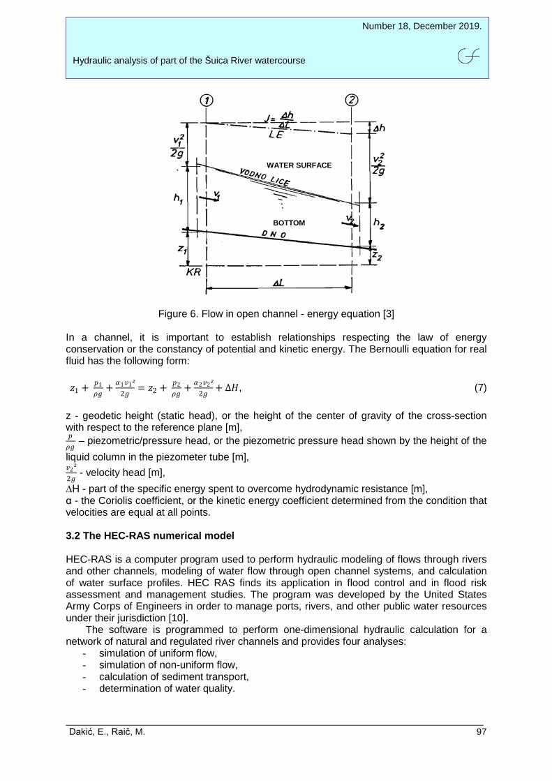
Figure 6. Flow in open channel - energy equation [3] In a channel, it is important to establish relationships respecting the law of energy conservation or the constancy of potential and kinetic energy. The Bernoulli equation for real fluid has the following form: 𝑧𝑧1 + 𝑝𝑝1
𝜌𝜌𝑡𝑡+ 𝛼𝛼1𝑣𝑣1²
2𝑡𝑡= 𝑧𝑧2 + 𝑝𝑝2
𝜌𝜌𝑡𝑡+ 𝛼𝛼2𝑣𝑣2²
2𝑡𝑡+ ∆𝐻𝐻, (7)
z - geodetic height (static head), or the height of the center of gravity of the cross-section with respect to the reference plane [m], 𝑝𝑝𝜌𝜌𝑡𝑡
– piezometric/pressure head, or the piezometric pressure head shown by the height of the liquid column in the piezometer tube [m], 𝑣𝑣2²2𝑡𝑡
- velocity head [m], ∆H - part of the specific energy spent to overcome hydrodynamic resistance [m], α - the Coriolis coefficient, or the kinetic energy coefficient determined from the condition that velocities are equal at all points. 3.2 The HEC-RAS numerical model HEC-RAS is a computer program used to perform hydraulic modeling of flows through rivers and other channels, modeling of water flow through open channel systems, and calculation of water surface profiles. HEC RAS finds its application in flood control and in flood risk assessment and management studies. The program was developed by the United States Army Corps of Engineers in order to manage ports, rivers, and other public water resources under their jurisdiction [10]. The software is programmed to perform one-dimensional hydraulic calculation for a network of natural and regulated river channels and provides four analyses:
- simulation of uniform flow, - simulation of non-uniform flow, - calculation of sediment transport, - determination of water quality.
WATER SURFACE
BOTTOM
Dakić, E., Raič, M. 97

Number 18, December 2019.
Hydraulic analysis of part of the Šuica River watercourse
It is used to calculate steady or unsteady flow in a network of open flows of irregular geometry, with different external and internal boundary conditions. Flow is calculated in calm, intermediate or turbulent mode. The calculation is based on solving a linear energy equation in which energy losses are covered through friction losses (over Manning's roughness coefficient) and local losses due to constriction / expansion of flow (through the coefficient of local energy loss) [10]. The initial step in the hydraulic calculation is to enter the river watercourse geometry (Figure 7). To define cross section, it is necessary to enter the coordinates of characteristic points, data on Manning's roughness coefficient, distances with respect to the first downstream section, positions of the points bounding the main riverbed, data on the local loss coefficients.
Figure 7. Orthophoto view of the watercourse scheme – HEC-RAS
Figure 8. View of input data for modeling in the software HEC-RAS Dakić, E., Raič, M. 98
Number 18, December 2019.
Hydraulic analysis of part of the Šuica River watercourse
4. Hydraulic analysis results The hydraulic calculation in the program HEC-RAS is conducted in the section for which steady non-uniform flow is assumed. The regulated riverbed of the Šuica river, as well as the corresponding trained cross sections of the watercourse were formed based on the data from geodetic surveys in the field and entered into HEC-RAS. The entered section is approximately 6 km in length and 200 cross sections were entered. The analysis was carried out for two variants:
I. variant: elevation of the upper balancing reservoir of PSPP Vrilo is 860 m a.s.l. (PF1 scenario in the software),
II. variant: elevation of the upper balancing reservoir of PSPP Vrilo is 859 m a.s.l. (PF2 scenario in the software).
The calculation was made for the relevant flow along the section of Q = 8.20 m3/s and for the boundary conditions: longitudinal slope of the riverbed bottom of 0.293 ‰ and known water level.
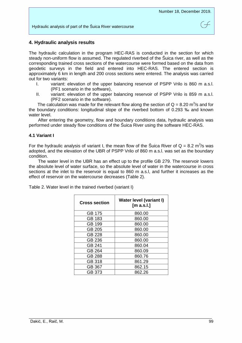
After entering the geometry, flow and boundary conditions data, hydraulic analysis was performed under steady flow conditions of the Šuica River using the software HEC-RAS. 4.1 Variant I For the hydraulic analysis of variant I, the mean flow of the Šuica River of Q = 8.2 m3/s was adopted, and the elevation of the UBR of PSPP Vrilo of 860 m a.s.l. was set as the boundary condition.
The water level in the UBR has an effect up to the profile GB 279. The reservoir lowers the absolute level of water surface, so the absolute level of water in the watercourse in cross sections at the inlet to the reservoir is equal to 860 m a.s.l, and further it increases as the effect of reservoir on the watercourse decreases (Table 2). Table 2. Water level in the trained riverbed (variant I)
Cross section
Water level (variant I)
[m a.s.l.]
GB 175 860.00 GB 183 860.00 GB 199 860.00 GB 205 860.00 GB 228 860.00 GB 236 860.00 GB 241 860.04 GB 264 860.09 GB 288 860.76 GB 318 861.29 GB 367 862.15 GB 373 862.26
Dakić, E., Raič, M. 99

Number 18, December 2019.
Hydraulic analysis of part of the Šuica River watercourse
Figure 9. View of the distribution of flow velocities along the considered watercourse section - PF 1
4.2 Variant II For the hydraulic analysis of variant II, the mean flow of the Šuica River of Q = 8.2 m3/s was adopted, and the elevation of the UBR of PSPP Vrilo of 859 m a.s.l. was set as the boundary condition. In this calculation variant, the absolute level of water surface is reduced by 1 m, which results in increased velocities on the section on which the reservoir has an effect on the watercourse. Table 3. Water level in the trained riverbed (variant II)
Cross section
Water level (variant II)
[m a.s.l.]
GB 175 590.00 GB 183 859.00 GB 199 859.00 GB 205 859.05 GB 228 859.15 GB 236 859.20 GB 241 859.73 GB 264 860.06 GB 288 860.76 GB 318 861.29 GB 367 862.15 GB 373 862.26
Dakić, E., Raič, M. 100

Number 18, December 2019.
Hydraulic analysis of part of the Šuica River watercourse
Figure 10. View of the distribution of flow velocities along the considered watercourse section - PF 2
The points corresponding to the places with highest velocities (Figure 10) represent the Šuica River cross sections at which high velocities develop due to constricted riverbed cross sections. Figure 10 clearly represents the situation of increasing velocities with decreasing water levels in the section where the level of water from the upper balancing reservoir influences the Šuica River watercourse. At the point where the influence ceases, velocities become equal. The upper balancing reservoir will have the direct and biggest influence on the cross sections from GB 174 to GB 279 for both cases - both variants (PF 1 and PF 2). The values of the Froude number in the analyzed section after regulating the watercourse are less than 1, thus the flow regime in the trained watercourse is calm, which can be seen in the tabular output of results.
Figure 11. View of a part of aggregate results of the hydraulic analysis for both calculation variants: PF 1 and PF 2
Dakić, E., Raič, M. 101

Number 18, December 2019.
Hydraulic analysis of part of the Šuica River watercourse
Figure 12 provides a comparative view from HEC-RAS of water levels for both calculation variants at arbitrarily selected riverbed cross sections.
Figure 12. View of water levels at the cross sections GB 228, GB 236, GB 241 and GB 264 5. Conclusion The regime of a natural watercourse is dynamic and complex. It includes all changes occurring over time, caused by precipitation, evapotranspiration, changes in temperature, vegetation, saturation of soil with moisture, geological, pedological and other characteristics of the basin. In many ways, the river watercourse makes human life easier/harder and contributes to the social and economic aspect of surrounding settlements. Therefore, regulation of watercourses is approached rationally, conscientiously and in accordance with the natural laws of river flow. The goals are clear: flood control, maximum utilization of water resources for water supply, hydropower supply, recreation, prevention of erosion or collapse of banks, protection and improvement of the environment, etc. The main characteristics of the observed Šuica River basin are long and dry summers in which the watercourses dry up, and flooding of large field areas during high water. The reason for this is the low capacity of natural runoff indicating the need to regulate the flow regime in the basin. The planned interventions on the PSPP Vrilo facility will not endanger the life and work of the population or contaminate natural resources, but it will encourage settlement and employment in the area. The construction of the PSPP Vrilo reservoirs is expected to
Dakić, E., Raič, M. 102

Number 18, December 2019.
Hydraulic analysis of part of the Šuica River watercourse
improve the water supply systems and the possibility of irrigation, which significantly contributes to the development of the agricultural sector.
Analysis of the new conditions in the Šuica riverbed after training the watercourse shows that increasing the high water evacuation capacity significantly reduces the frequency and area of Duvanjsko Polje flooding (up to 4 m in terms of height, or about 80% of the flood area), and reduces water retention in natural depressions.
The use of the HEC-RAS numerical model proved to be justified in the hydraulic analysis of the part of the Šuica River watercourse.
A recommendation for future research is to establish continuous monitoring of water levels and surface water and groundwater quantities of Duvanjsko Polje in order to form a database that would be used to verify results of numerical models, as well as accuracy of results of future hydraulic analyses. 6. References 1. Gjetvaj, G.: Praktikum iz hidraulike: postupno promjenjivo tečenje u otvorenom koritu
(numerički model), (str. 1-14), Građevinski fakultet Sveučilišta u Zagrebu, Zagreb, 2012. 2. Gjetvaj, G.: Rukopis predavanja iz predmeta Hidraulika: tečenje u otvorenim koritima,
Zagreb, 2006. 3. Kupusović, T.: Predavanja iz Hidraulike, Sarajevo, 1984. 4. Marasović, M., Barišić, M.: CHE Vrilo- Idejni projekt, Izbor veličine izgradnje, Knjiga G2-
K52.00.01-G02.0, Elektroprojekt d.d., Zagreb, 2010. 5. Marasović, M., Orlović, D., Staničić, L., Pavlin, Ž., Sever, Z.: CHE Vrilo- Idejni projekt,
tekst, Knjiga Y2-K52-00.01-G03.1, Elektroprojekt d.d., Zagreb, 2010. 6. Mladenović, B. M.: Uređenje vodotoka, Institut za vodoprivredu Jaroslav Černi, Beograd,
2018. 7. Pavlin, Ž., Šelemba, I., Sever, Z., Marasović, M.: CHE Vrilo- Idejni projekt, nacrti, Knjiga
Y2-K52-00.01-G03.2, Elektroprojekt d.d., Zagreb, Sarajevo, 2010. 8. Puljić, B., Dragoje, E., Prlić, Š. M., Laganin, M., Mandić, D., Škobić, D., Koštroman, S.
S., Mišetić, S., Marasović, M., Kereković, A., Kerovec, M., Štefanac, S.: Studija o utjecaju na okoliš za CHE Vrilo, Ecoplan d.o.o Mostar, Elektroprojekt d.d. Zagreb, 2010.
9. www.google.com/maps. 10. www.hec.usace.army.mil. 11. Dakić, E.: Hidraulička analiza dijela vodotoka rijeke Šuice, diplomski rad, Građevinski
fakultet Sveučilišta u Mostaru, Mostar, 2019.
Dakić, E., Raič, M. 103