huu ay aht first nation hfn community forest...
TRANSCRIPT
HHuuuu‐‐aayy‐‐aahhtt FFiirrsstt NNaattiioonn
HFN Forestry Limited Partnership • www.huuayaht.org • 1–250–728–3080 • [email protected]
HHFFNN CCoommmmuunniittyy FFoorreesstt 11
Application for a Community Forest Agreement
Prepared for: The Ministry of Forests and Range Coast Forest Region
2100 Labieux Road Nanaimo, BC V9T 6E9 Ph. (250) 751‐7001 Fax (250) 751‐7190
October 1, 2010
Prepared by:
HFN Forestry Limited Partnership P.O. Box 200,
Bamfield, BC VOR 1BO. Ph. (250) 728‐3080 Fax (250) 728‐3081
E‐mail [email protected]
_____________________
A.P. Dagg, RPF
I certify that I have reviewed this document and, while I did not personally supervise the work described, I have determined that this work has been done to the standards of a member of the Association of British Columbia Forest Professionals.

HFN Limited Partnership • Application for a Community Forest Agreement • Page 2
HFN Forestry Limited Partnership • www.huuayaht.org • 1–250–728–3080 • [email protected]
We, the Huu-ay-aht people, envision a proud, self-governing sovereign Nation. Isaak will guide us as we work together to establish a healthy, prosperous, self-sustaining community where our culture, language, spirituality and economy flourish for the benefit of all Huu-ay-aht.
Huu-ay-aht First Nation Vision Statement


HFN Limited Partnership • Application for a Community Forest Agreement • Page 5
HFN Forestry Limited Partnership • www.huuayaht.org • 1–250–728–3080 • [email protected]
1.0 EXECUTIVE SUMMARY ................................................................................................................................................ 7
HFN CFA1 GOALS .......................................................................................................................................................................... 10
GUIDING PRINCIPLES ........................................................................................................................................................................ 11
2.0 DISTRICT DOCUMENTATION REQUIREMENTS ............................................................................................................12
3.0 CONSISTENCY WITH PROVINCIAL COMMUNITY FOREST PROGRAM OBJECTIVES ........................................................14
4.0 LEGAL ENTITY .............................................................................................................................................................16
5.0 HFN CFA1 AREA DESCRIPTION ....................................................................................................................................17
6.0 HISTORICAL USE .........................................................................................................................................................18
6.1 FIRST NATIONS................................................................................................................................................................... 18
6.2 INDUSTRIAL DEVELOPMENT ................................................................................................................................................... 19
6.3 THE VILLAGE OF BAMFIELD ................................................................................................................................................... 20
6.4 THE CITY OF PORT ALBERNI ................................................................................................................................................... 21
7.0 LAND USE VISION .......................................................................................................................................................22
8.0 STATEMENT OF GOALS AND GUIDING PRINCIPLES .....................................................................................................22
8.1 HFN CFA1 GOALS ............................................................................................................................................................. 22
8.2 GUIDING PRINCIPLES ........................................................................................................................................................... 24
9.0 OWNERSHIP, EXISTING TENURES, AND RIGHTS GRANTED TO OTHERS .......................................................................24
9.1 FIRST NATIONS................................................................................................................................................................... 24
9.2 TRAPPERS ......................................................................................................................................................................... 25
9.3 GUIDE OUTFITTERS ............................................................................................................................................................. 25
10.0 STATE OF LAND AND FOREST RESOURCES ..................................................................................................................26
10.1 CURRENT MANAGEMENT ..................................................................................................................................................... 26
10.2 FOREST CLASSIFICATION ....................................................................................................................................................... 28
10.2.1 Age Classes and Species Composition ................................................................................................................... 28
10.2.2 Site Index (Growth rates) ...................................................................................................................................... 28
10.2.3 Biogeoclimatic Zones ............................................................................................................................................ 28
10.3 ROADS AND PUBLIC ACCESS CONSIDERATIONS ........................................................................................................................... 30
10.3.1 Public Access and Safety ....................................................................................................................................... 30
10.3.2 Roads .................................................................................................................................................................... 31
11.0 CULTURAL CONSIDERATIONS .....................................................................................................................................34
12.0 ENVIRONMENTAL CONSIDERATIONS .........................................................................................................................35
12.1 WATER RESOURCES AND FISH HABITAT PROTECTION .................................................................................................................. 35
12.2 WATERSHED BACKGROUND .................................................................................................................................................. 37
12.2.1 Watershed Strategies ........................................................................................................................................... 37
12.3 PROTECTION AND/OR CREATION OF WILDLIFE HABITAT ............................................................................................................... 38
12.3.1 Old Growth Management Areas ........................................................................................................................... 38

HFN Limited Partnership • Application for a Community Forest Agreement • Page 6
HFN Forestry Limited Partnership • www.huuayaht.org • 1–250–728–3080 • [email protected]
12.3.2 Wildlife Habitat Structure and Features ............................................................................................................... 38
12.3.3 Management of Old Growth ................................................................................................................................ 39
Management of NTFPs ........................................................................................................................................................... 40
13.0 PROPOSED ALLOWABLE ANNUAL CUT .......................................................................................................................40
14.0 NOT FOR PUBLIC DISCLOSURE ....................................................................................................................................41
15.0 APPENDICES ..............................................................................................................................................................42
APPENDIX A AGREEMENT HOLDER LEGAL IDENTITY INFORMATION
APPENDIX B TIMBER SUPPLY ANALYSIS
APPENDIX C TRAPPER REFERRAL LETTER AND CFA1 MAP

HFN Limited Partnership • Application for a Community Forest Agreement • Page 7
HFN Forestry Limited Partnership • www.huuayaht.org • 1–250–728–3080 • [email protected]
1.0 Executive Summary
The land use vision of the proposed HFN Community Forest is to put control of lands and resources into the hands of the Huu‐ay‐aht First Nation people by building a financially viable timber and non‐timber forest resource business which provides benefits to the Huu‐ay‐aht First Nation community and the local community at large and manages the forest sustainably while achieving a balance between community values and practicable management. The Community Forest shall be a business opportunity to provide more stability for our local communities and provide long term employment opportunities.
The Huu‐ay‐aht First Nation was invited to apply for a Community Forest Agreement in on October 1, 2007. The invitation was for an area able to support an Annual Allowable Cut of 16,992 cubic meters. The 16,992 cubic meters shall be provided under Section 4.2.2 of the Huu‐ay‐aht First Nation Stage 5 Treaty Interim Measures Renewal and Replacement Agreement. Huu‐ay‐aht First Nation Forestry Limited Partnership (HFN Forestry) is the group which has prepared the application, and the Management Plan.
The Huu‐ay‐aht First Nation people welcome the Community Forest Agreement as an opportunity to enhance community prosperity. The community forest will create jobs and be the catalyst for other economic initiatives that are greatly needed in the community. Timber will be the main product of the community forest; however non‐timber forest products initiatives like botanical harvesting and value‐added manufacturing will be strongly encouraged and supported. Training and skill upgrading will be an integral part of all initiatives.
The proposed CFA lands have been used by the Huu‐ay‐aht First Nation since time immemorial. The general area of the CFA is considered to have a high cultural value to the Huu‐ay‐aht First Nation because of historical use which includes gathering sites, hunting and fishing areas, camps, meeting sites, and archaeological and sacred sites. The Pacific coastline of Vancouver Island is also renowned for the unique culture and traditions of the Nuu‐chah‐nulth speaking First Nations who have flourished here for thousands of years. One of the world's richest coastal temperate forests, featuring towering hemlock, balsam, spruce, cedar and fir trees has been nurtured by the warmth, fog and rain of Pacific Ocean currents, and fed by countless rivers and streams flowing from majestic snow‐capped mountains. The traditional territories (see Huu‐ay‐aht First Nation traditional territory map) of the Huu‐ay‐aht First Nation, one of the Nuu‐chah‐nulth speaking tribes, encompass some of the richest portions of this remarkable environment. Islands, bays, beaches, streams, rivers, and vast forests, hills and mountains, all form part of this remarkable landscape.
The Huu‐ay‐aht First Nation has a long and proud history in their traditional territories. Their histories extend back to the beginning of time, and tell of many great people, adventures, traditions and deeds.
In the past, Huu‐ay‐aht ancestors drew all they required from nature's abundant bounty. Offshore, the ocean supplied halibut, cod, snapper, herring and other fish, as well as seals, sea lions, and whales. When the tide was low, mussels, clams, chitons, urchins and more would be collected and eaten. On land, many plant foods, including a wide variety of berries would ripen and be gathered. From the summer through late fall, five species of Pacific salmon returned to their spawning rivers, where the Huu‐ay‐aht people went to the rivers to catch, smoke and dry the fish in preparation for the coming winter. Throughout the year, land mammals, including elk, deer and bear, were hunted for their meat and fur. Huu‐ay‐aht ancestors lived in close harmony with nature and drew all they required for living from what nature provides. Today the Huu‐ay‐aht First Nation continues to believe in a close relationship between the spiritual and natural worlds.
This application follows the required format of the government document entitled “Community Forest Agreement (CFA) Application Requirements (Direct Invitation to Apply)” July 1, 2009 Version.

HFN Limited Partnership • Application for a Community Forest Agreement • Page 8
HFN Forestry Limited Partnership • www.huuayaht.org • 1–250–728–3080 • [email protected]
The Community Forest will be held and operated by the General Partner (568157 B.C. Ltd.) within HFN Forestry Limited Partnership (HFN Forestry) as described in Section 3, Legal Entity. HFN Forestry is comprised of the following:
General Partner 568157 B.C. Ltd. and Limited Partner 568159 B.C. Ltd. (568159 B.C. Ltd. is a wholly owned subsidiary that represents the Huu‐ay‐aht First Nation in the Limited Partnership.)
The Community Forest will be held for the benefit of the Huu‐ay‐aht First Nation and HFN Forestry shall be accountable through ongoing reporting to the Board of Directors and the Board of Directors shall report to the Huu‐ay‐aht Chief and Council.
The Huu‐ay‐aht Community Forest Agreement area is located approximately 20km north east of the town of Bamfield. It is adjacent to the Huu‐ay‐aht treaty settlement lands and within the core territory.
The proposed HFN Community Forest Agreement A1 (CFA1) is mostly located within the Sarita Landscape Unit with a small area located within the Klanawa Landscape Unit. The Sarita and Klanawa Landscape Units (LUs) are located on the west coast of British Columbia south and east of Barkley Sound. The major drainage in the Sarita LU that is in the vicinity of the CFA1 is the Sarita River. Sarita Lake is the largest lake in the vicinity of the CFA1. The HFN CFA1 is comprised of four distinct polygons or Units: Spencer Creek (West Unit), Blenheim Unit, Spencer Creek (East Unit), & the Central & Harris Creek Unit. The proposed HFN CFA1 area is discontinuous and it extends from just east of Numukamis Bay and south of May Lake to the easternmost unit in the Central Main North/Harris Creek Main Unit. These areas total 2345 hectares. The Forest Minister signed the deletion order to remove the HFN CFA1 area from TFL 44 on May 17, 2010.
A single biogeoclimatic zone covers the Sarita and Klanawa Landscape Units, the Coastal Western Hemlock (CWH). There are three biogeoclimatic subzones present, the CWH Submontane very wet maritime (CWHvm1), CWH Montane very wet maritime (CWHvm2) and CWH southern very wet Hypermaritime (CWHvh1).
A description of the areas can be found in the application Section 4, HFN CFA Area Description and Section 9, Ownership, existing tenures, and rights granted to others as well as Section 10.5, Biogeoclimatic Zones for the four units. The areas are illustrated on the 1:20,000 scale maps attached to this application.
The Huu‐ay‐aht First Nation will manage the diversity of values of the Huu‐ay‐aht First Nation Community Forest 1 in an ecologically responsible and fiscally accountable manner.
In order for this to happen the Huu‐ay‐aht Forestry Planning Department will consult with the Huu‐ay‐aht Chief and Council regarding any CFA1 resource Management Plans, decisions and matters of significance. We will regularly review our practices and procedures to monitor and report to the Huu‐ay‐aht Chief and Council on environmental performance. This will constitute the appropriate internal consultation process.
The Huu‐ay‐aht First Nation participation in resource management is based on their cultural values of good stewardship, sustainable use and sharing.
Following the Huu‐ay‐aht First Nation’s guiding principles of sustainability; we will manage our forest and fishery resources in a sustainable manner that is environmentally appropriate, socially beneficial and economically viable.
Attached to the Management Plan is a Timber Supply Analysis Report (TSA Report) CFA completed by Forest Ecosystems Solutions Ltd. (FESL). The analysis adheres to the general management of and modeling assumptions as provided in TFL 44 Management Plan #4 completed in 2002, and it incorporates updates for disturbances to 2009, updated land base reductions for new/updated resource emphasis areas (draft OGMAs, UWR) and

HFN Limited Partnership • Application for a Community Forest Agreement • Page 9
HFN Forestry Limited Partnership • www.huuayaht.org • 1–250–728–3080 • [email protected]
elimination of territorial overlap with other First Nations. FESL completed the analysis using the accepted forest estate modeling software FSOS.
The gross area of the CFA is 2,345 ha with productive forested area of 2,213 ha (94%) and a current timber harvesting land base (THLB) of 1,618 ha (68%). The existing volume for proposed CFA is composed primarily of hemlock and balsam (60%), Douglas‐fir (20%) and cedar (20%). Eighty percent of the THLB is within the CWHvm1 while twenty percent is within CWHvm2. Based on projecting the inventory and accounting for harvest (approximate to 2010), 39% of the CFA THLB is greater than 140 years old, while 60% of stands are less than 61 years.
Based on profile comparisons with TFL 44 and Alberni East, the CFA exhibits a similar operability and harvest system distribution. In terms of stand ages, the CFA has a higher proportion of old forest but also exhibits a more significant age class gap than does the TFL or Alberni East. Based on area weighted by leading species, the CFA has a higher proportion of western hemlock and lower proportions of cedar and Douglas‐fir. However, based on volume, the CFA is relatively similar to TFL44 while Alberni East exhibits a slightly higher proportion of cedar and hemlock/balsam volume and less Douglas‐fir volume. The CFA has a higher proportion of moderate sites with less good and high sites than the TFL and Alberni East.
Three alternative harvest projections were completed for this report, including a maximum short‐term, gradual step down, and a target AAC. The maximum short‐term harvest is a declining even flow with a harvest of 18,828 m3/year for the next twenty years, then a one time decline to 15,766 m3/year for the remainder of the analysis horizon (250 years). The long‐term harvest for this scenario is 86.4 % of the 18,257 m3/year LRSY and almost 11% higher than the proposed AAC for the CFA. A similar scenario was completed which incorporated a gradual decline (1%/year) and illustrated that the same short/long term harvest projection can be maintained with a declining growing stock after 250 years. Finally, a target AAC scenario was completed which illustrated that 16,992 m3/year can be maintained for 45 years and decline gradually to the same long‐term harvest level of 15,766 m3/year. The application and the Management Plan for CFA are consistent with the Management Assumptions – Harvesting Rules noted on page 23 of the TSA report.
The application for a community forest agreement details district documentation requirements, explanations of the legal entity, area descriptions, historical land use, the Huu‐ay‐aht land use vision, the Huu‐ay‐aht stated goals and guiding principles, ownership, existing tenures and rights granted to others, state of land and forest resources, cultural considerations, environmental considerations, proposed allowable annual cut and a section entitled not for public disclosure.
The roles of the Board of Directors, management and governance structure, contractors and the public in the successful implementation of this strategy are clearly defined in the Sections 9 and 10 of the Management Plan (community awareness, support and involvement and administrative authority and structure).
Discussions have been held with stakeholders and one open house meeting for further consultation also occurred at the village of Anacla with the Huu‐ay‐aht members and the residents of Bamfield as part of the initial application process.
HFN has implemented a broad‐based strategy to ensure community awareness of the application, consisting of direct outreach by mail, notices on public notice boards, publishing of materials on the HFN CFA website and a community survey on the web site. Documentation of community support and awareness is included in the CFA application as well as information on the web site, the open house, the community survey, and letters of support, stakeholder consultation and First Nations’ consultation. Public consultation will play a vital role in the success of HFN Forestry’s management strategy by increasing the organization’s public credibility, improving public awareness and expanding the knowledge base to develop new ideas and workable strategies.

HFN Limited Partnership • Application for a Community Forest Agreement • Page 10
HFN Forestry Limited Partnership • www.huuayaht.org • 1–250–728–3080 • [email protected]
The Management Plan also details the management objectives for all of the timber and non‐timber values and resource objectives as well as non‐timber forest products.
The Management Plan document discusses resource management objectives pertaining to governing legislation, priorities and methods for timber harvesting, protection and conservation of non‐timber values and resources, fire protection, forest health, silviculture and roads. HFN Forestry resource management methods consistently adhere to an overall strategy of balancing sustainable environmental management with focused economic, social and cultural objectives. It will combine adherence to existing forest policy and legislation with a commitment to seek innovative local solutions to industry
Results from the web based “community support, awareness and management survey” demonstrated 93.8% of responding residents of Port Alberni, Bamfield, the Village of Anacla and other Vancouver Island residents voted “yes” to the question “Do you support the concept of a community forest, managed and operated for the benefit of the Huu‐ay‐aht First Nation community and the community at large?”
Letters of support have been provided by neighboring licence holders, community organization members, suppliers and contractors. Documentation of community support awareness and involvement is found in Appendix F of the Management Plan.
Ongoing stakeholder involvement will occur through the continuation of the web site.
We will educate the Huu‐ay‐aht First Nation community and the community at large on forest resource matters via ongoing dialogue with the Huu‐ay‐aht First Nation band Council and the communities. We will also encourage links with the Vancouver Island University (VIU) Forestry Department related to education and mutually beneficial research and projects.
The business and management plans for the community forest are technical and socio‐economic documents. The following goals and guiding principles provide direction to the planning team and the resource managers:
HFN CFA1 Goals
Promote a high standard of safety for workers and forest users.
Demonstrate forestry practices based on community values.
Follow the Huu‐ay‐aht First Nation’s guiding principles of sustainability. We will manage our forest and fishery resources in a sustainable manner that is environmentally appropriate, socially beneficial and economically viable.
Promote a diverse use of the land base.
Maximize the social and economic benefits to our communities and the province of British Columbia by harvesting in a prudent manner that is sensitive to the needs of our environment and our community.
Encourage cooperation among stakeholders.
We will minimize environmental impact, prevent pollution and strive for continuous improvement of our environmental performance.
We will operate in compliance with all applicable laws pertaining to the environment.
We will regularly review our practices and procedures to monitor and report on environmental performance.
Fulfill the cut control obligations of the licence while meeting the standards set in forest legislation and maintaining high standards of environmental stewardship.

HFN Limited Partnership • Application for a Community Forest Agreement • Page 11
HFN Forestry Limited Partnership • www.huuayaht.org • 1–250–728–3080 • [email protected]
Guiding Principles
Make safety the highest priority.
The Huu‐ay‐aht First Nation participation in resource management is based on their cultural values of good stewardship, sustainable use and sharing.
Follow a sound business plan that will ensure economic self‐sufficiency and will enhance community economic diversity and stability on a continuing basis.
Practice community forestry consistent with high standards of environmental stewardship.
Encourage communication in all activities by maintaining open dialogue with the community about forest management and by maintaining an up‐to‐date web page on forest activities.
The business plan is described in Section 12 of the Management Plan, Business Plan Components. Appendix G of the Management Plan contains the projected financial statements and basic financial cost assumptions plus a detailed list of the anticipated start‐up costs.
We intend to maximize value from the harvested timber. Revenues and profits in the Projected Income Statement 2011‐2015 (Appendix G) have been derived assuming the anticipated product mix. However, adjustments to the available product mix can seriously alter revenues and therefore profits. While HFN Forestry will focus closely on efforts to optimize its product mix, it recognizes that the actual product mix obtained from a given stand of timber can be quite different from what is initially projected based on area reconnaissance, timber cruising and engineering. For this reason, “best case” and “worst case” scenarios shall be used in projected log profile and revenues. Species and product mix are two variables that need to be adjusted to reflect the potential range in revenues.
HFN Forestry is fortunate to have an excellent harvesting and road construction track record due to careful management and supervision and the use of excellent tried and true road contractors, loggers and the skilled HFN Spencer dry land sort crew.
The implementation plan or start‐up is vital to our success. As with any business, HFN Forestry’s greatest challenge will occur during the start‐up phase of operations. Once the community forest licence is awarded, funds to complete a Forest Stewardship Plan pay the first year’s AAC rental, and layout the first cutblocks will be required. Careful forecasting of start‐up costs and a solid plan for the procurement of funds is essential in order to ensure that the company does not suffer a cash shortfall before revenues begin to accrue sufficiently to cover costs.
Total start‐up costs are forecasted to be $1,018,361.
HFN Forestry is well positioned for the required start‐up funding. However, if needed, part of the operating capital can be acquired from sources used by other small licensees who include:
Log brokers provide operating capital in return for the commission rights to sell the timber. The fees for this are usually in the neighbourhood of prime rate plus 2%, and $3 per m3 to sell the wood.
Contract with a larger customer for advances against the purchase price of the logs.
Once the community forest is operating, HFN Forestry intends to hold cash reserves equal to the cost of planning for one year’s AAC, building 1.44 kilometers of road, and planting the previous year’s harvested area. Retaining approximately $279,470 in the business will allow for self financing of operations, and provide the needed flexibility to manage the forestry business.

HFN Limited Partnership • Application for a Community Forest Agreement • Page 12
HFN Forestry Limited Partnership • www.huuayaht.org • 1–250–728–3080 • [email protected]
We look forward to the opportunity to manage long term forest tenure in a sustainable manner that is environmentally appropriate, socially beneficial and economically viable.
2.0 District Documentation Requirements
This section must include written confirmation from the district manager that the proposed CFA area is suitable for a CFA and is consistent with the AAC allocated for the agreement.

HFN Limited Partnership • Application for a Community Forest Agreement • Page 13
HFN Forestry Limited Partnership • www.huuayaht.org • 1–250–728–3080 • [email protected]
Letters demonstrating support of the CFA1 are being sought from the Tseshaht, Uchucklesaht and Ditidaht First Nations.

HFN Limited Partnership • Application for a Community Forest Agreement • Page 14
HFN Forestry Limited Partnership • www.huuayaht.org • 1–250–728–3080 • [email protected]
3.0 Consistency with Provincial Community Forest Program Objectives
Community Forest tenure is intended to provide new opportunities for community management of Crown forest land. By providing communities with greater flexibility to manage local forests, government seeks to achieve eight objectives. The Huu‐ay‐aht Community Forest 1 (HFN CFA1) management objectives are consistent with Provincial Community Forest Agreement program objectives as follows:
1. Provide long‐term opportunities for achieving a range of community objectives, values and priorities.
The community forest will be a well‐managed forest area, with best management practices based on values, priorities and objectives from stakeholders rather than a focus on management only for shareholders profit. The Huu‐ay‐aht First Nation and the entire Alberni Valley will benefit from the community forest and the values outlined in a public survey and during community consultation have been incorporated to produce a holistic management plan.
2. Diversify the use of, and benefits derived from, the community forest agreement area.
A broad range of users have historically benefited from access to the resources on the HFN CFA1 land base. The HFN CFA1 will continue to provide diverse opportunities to locals and visitors to enjoy the forest as a model of mixed‐use forest management. In addition to harvesting opportunities, the Spencer Creek (West), Spencer Creek, Blenheim Main, Central Main North /Harris Creek Main Operating Areas have been, and will continue to be, used for recreation, wildlife, and for conservation of biodiversity. Typical recreation uses are camping, fishing, swimming and boating. Huu‐ay‐aht First Nation clamming at Numukamis Bay within HFN IR #1 is another activity. (The Spencer Creek West Unit drains via Carnation Creek into Numukamis Bay).
The polygons in the Central Main North /Harris Creek Main Unit will be within visual polygon #0225 in the available TFL 44 Visual Landscape Inventory. The areas will continue to be the background landscape as part of the Bamfield Mainline travel corridor. The Spencer Creek (West) and Spencer Creek/Blenheim Main Units will likely be in visual polygon #0877. The visual quality objective is partial retention the most open view of the operational area is likely from Trevor Channel off San Mateo Bay. The Spencer operational area is north of Sarita Lake. The views from Trevor Channel will be screened by vegetation and topography. The most open views will likely be from the Bamfield Main travel corridor. Proposed alteration will likely be partly visible. It will be seen as a visual disturbance within the criteria of modification. The proposed development will have positive design elements that blend the alteration with the landform. The design of any development in any of the polygons will strive to blend with the landscape with foreground topography and vegetation screening.
The HFN CFA1 will encourage and facilitate economic diversification of the Alberni Valley through non‐timber forest products businesses, ecotourism and guide‐outfitting. We will manage our forest resources in a sustainable manner that is environmentally appropriate, socially beneficial and economically viable. We will manage the forest resource to balance forest values to meet economic and cultural needs of peoples within the ha‐houlthee of the Huu‐ay‐aht Ha’wiih, including the Huu‐ay‐aht First Nation peoples.
3. Promote community involvement and participation.
Widespread community involvement was sought during the HFN Community Forest 1 public consultation initiative. The HFN CFA1 will incorporate community values and objectives where compatible with the goal of creating a financially viable timber and non‐timber forest resource business. This business will provide benefits to the community while it practices sustainable use of forests while balancing community values and practicable management. As the project progresses, the HFN CFA1 activities will remain transparent by communicating plans online, via the media, and through annual reports.

HFN Limited Partnership • Application for a Community Forest Agreement • Page 15
HFN Forestry Limited Partnership • www.huuayaht.org • 1–250–728–3080 • [email protected]
4. Provide social and economic benefits to British Columbia.
The HFN CFA1 will provide stumpage revenue to the people of British Columbia from an average of 16,992 m3/year, in addition to the many social and economic benefits of timber and non‐timber forest products harvesting to the local community. Some of the products will be transported to conversion mills in the local community while some products will be transported to other areas of Vancouver Island and elsewhere.
Profits from the community forest will be returned to the HFN community and for improvements to the HFN community forest. The community forest will provide a tool to help stabilize the Huu‐ay‐aht First Nation local economy and provide long term employment opportunities. The CFA1 will encourage communication and strengthen relationships between the Aboriginal and non‐Aboriginal communities and persons.
Public benefits will also be available in the form of Timbered Leave Areas and Wildlife Tree Retention Areas for non‐timber values important for stream protection, old growth, wildlife, visuals and biodiversity. These areas often coincide with recreational areas that also provide social benefits to stakeholders.
5. Undertake community forestry consistent with sound principles of environmental stewardship that reflect a broad spectrum of values.
Broad spectrums of values were used in the preparation of this Management Plan. Values that were input into the Management Plan were derived from community discussions during the HFN Community Forest 1 public consultation initiative, the online questionnaire, the Huu‐ay‐aht First Nation’s guiding five principles of sustainability and legislated requirements that reflect objectives of the people and government of British Columbia. Each of these groups has its unique vision of environmental care and stewardship. The Management Plan incorporates the diverse ideals and optimizes values consistent with a community forest vision.
6. Foster Innovation.
The HFN CFA1 will encourage innovative forest practices by identifying gaps in knowledge and skills and by providing the training and information where required. We will use adaptive management approaches in order to improve planning, management, productivity and forest practices with sustainable development as the goal. The land base will also be accessible to the community for non‐timber forest management.
7. Advocate forest worker safety.
Huu‐ay‐aht First Nation Forestry doing business as HFN Forestry Limited Partnership is a “Safe Certified” company with the BC Forest Safety Council. We have a full time consultant as the manager of our safety program, with full interaction and communication with all of our forestry contractors. We strive for continuous improvement in safety. All of our contracted workers must have WorkSafeBC coverage and be “Safe Certified” with the BC Forestry Safety Council to work on the HFN CFA1 land base or any of our Huu‐ay‐aht forestry tenures.
8. Promote communication and strengthen relationships between Aboriginal and non‐Aboriginal communities and persons.
The HFN Forestry management team for the HFN CFA1 will report on a regular basis and provide annual reports to the Huu‐ay‐aht First Nation Chief and Council representing the Huu‐ay‐aht First Nation people. This will ensure that the Huu‐ay‐aht First Nation’s guiding five principles of sustainability will be upheld in the management of the CFA1. Open communication will be maintained with the three other First Nations that have traditional territory outside the CFA1 boundaries but in the vicinity of the CFA1 boundaries.

HFN Limited Partnership • Application for a Community Forest Agreement • Page 16
HFN Forestry Limited Partnership • www.huuayaht.org • 1–250–728–3080 • [email protected]
These are the:
Ditidaht First Nation
Uchucklesaht Tribe
Tseshaht First Nation
This open communication will guide communications and the on‐going relationship between the aboriginal and non‐aboriginal community.
Values that were input into the Management Plan were derived from community discussions during the HFN Community Forest 1 public consultation initiative, the online questionnaire, the Huu‐ay‐aht First Nation’s guiding five principles of sustainability, and legislative requirements that reflect objectives of the people and government of British Columbia. Each of these groups has its unique vision of environmental care and stewardship. The Management Plan incorporates the diverse ideals and optimizes values consistent with a community forest vision.
4.0 Legal Entity
The Community Forest will be held and operated by the General Partner (568157 B.C. Ltd.) within HFN Forestry Limited Partnership. HFN Forestry Limited Partnership is comprised of the following:
General Partner 568157 B.C. Ltd. and Limited Partner 568159 B.C. Ltd. (568159 B.C. Ltd. is a wholly owned subsidiary that represents the Huu‐ay‐aht First Nation in the Limited Partnership).
The Community Forest will be held for the benefit of the Huu‐ay‐aht First Nation and HFN Forestry Limited Partnership shall be accountable through ongoing reporting to the Board of Directors and the Board of Directors shall report to the Huu‐ay‐aht Chief and Council.
The Incorporation No. for 568157 B.C. Ltd. is BC0568157. The mailing address is HFN Forestry Limited Partnership P.O. 200, Bamfield, BC VOR 1BO. The HFN Forestry Limited Partnership (HFN Forestry) was incorporated as a limited company on July 13, 1998 to pursue forest based business opportunities. The board of directors of HFN Forestry is: Chief Councillor Robert Dennis, Lawrence Johnson, Derek Peters, and Connie Waddell. The officers of the Company are appointed by the directors, with their duties defined in the articles of the Company.
At present, the officers of the Company are:
Name Title
Robert Dennis President
Connie Waddell Secretary
HFN Forestry is in charge of the management of the forestry business for the Huu‐ay‐aht First Nation and it shall be in charge of the day to day decision‐making for the operation and management of the CFA1. HFN Forestry shall report to the HFN Forestry Board of Directors and the Board of Directors shall report to the Huu‐ay‐aht Chief and Council. The Board of Directors of HFN Forestry is accountable to the Huu‐ay‐aht Chief and Council.
Documentation for the legal entity is in Appendix A, Agreement Holder Legal Entity Information.

HFN Limited Partnership • Application for a Community Forest Agreement • Page 17
HFN Forestry Limited Partnership • www.huuayaht.org • 1–250–728–3080 • [email protected]
5.0 HFN CFA1 Area Description
Area of Crown Land: 2345 hectares.
Map References: Spencer Creek (West Unit), Blenheim Unit & Spencer Creek (East Unit): 092C.096; Central and Harris Creek Unit: 092C.087, 092C.096, and 092C.097.
General Location and Area Description: The Huu‐ay‐aht Community Forest Agreement area is located approximately 20km north east of the town of Bamfield. It is adjacent to the Huu‐ay‐aht treaty settlement lands and within the core territory. The CFA1 is comprised of four distinct polygons or Units: Spencer Creek (West Unit), Blenheim Unit, Spencer Creek (East Unit), & Central and Harris Creek Unit. These areas total 2345 hectares. The Forest Minister signed the deletion order to remove the HFN CFA1 area from TFL 44 on May 21, 2010. The area is shown outlined by a pink boundary in Figure 1.
Attached to this plan are 1:20,000 scale maps of the proposed HFN CFA1 units, including forest cover.
Figure 1 ‐ CFA1 Overview Location Map

HFN Limited Partnership • Application for a Community Forest Agreement • Page 18
HFN Forestry Limited Partnership • www.huuayaht.org • 1–250–728–3080 • [email protected]
6.0 Historical Use
6.1 First Nations
The Huu‐ay‐aht vision statement: “We, the Huu‐ay‐aht people, envision a proud, self‐governing sovereign nation. Isaak will guide us as we work together to establish a healthy, prosperous, self‐sustaining community where our culture, language, spirituality and economy flourish for the benefit of all Huu‐ay‐aht.”
The proposed CFA1 lands have been used by the Huu‐ay‐aht First Nation since time immemorial. The general area of the CFA1 is considered to have a high cultural value to the Huu‐ay‐aht First Nation because of historical use which includes gathering sites, hunting and fishing areas, camps, meeting sites, and archaeological and sacred sites. The Pacific coastline of Vancouver Island is also renowned for the unique culture and traditions of the Nuu‐chah‐nulth speaking First Nations who have flourished here for thousands of years. One of the world's richest coastal temperate forests, featuring towering hemlock, balsam, spruce, cedar and fir trees has been nurtured by the warmth, fog and rain of Pacific Ocean currents, and fed by countless rivers and streams flowing from majestic snow‐capped mountains. The traditional territories (see Huu‐ay‐aht First Nation traditional territory map Figure 2) of the Huu‐ay‐aht First Nation, one of the Nuu‐chah‐nulth speaking tribes, encompass some of the richest portions of this remarkable environment. Islands, bays, beaches, streams, rivers, and vast forests, hills and mountains, all form part of this remarkable landscape.
The Huu‐ay‐aht First Nation has a long and proud history in their traditional territories. Their histories extend back to the beginning of time, and tell of many great people, adventures, traditions and deeds.
In the past, Huu‐ay‐aht ancestors drew all they required from nature's abundant bounty. Offshore, the ocean supplied halibut, cod, snapper, herring and other fish, as well as seals, sea lions, and whales. When the tide was low, mussels, clams, chitons, urchins and more would be collected and eaten. On land, many plant foods, including a wide variety of berries would ripen and be gathered. From the summer through late fall, five species of Pacific salmon returned to their spawning rivers, where the Huu‐ay‐aht people went to the rivers to catch, smoke and dry the fish in preparation for the coming winter. Throughout the year, land mammals, including elk, deer and bear, were hunted for their meat and fur. Huu‐ay‐aht ancestors lived in close harmony with nature and drew all they required for living from what nature provides. Today the Huu‐ay‐aht First Nation continues to believe in a close relationship between the spiritual and natural worlds.
Fundamental to understanding Huu‐ay‐aht culture is the concept of the ha'wiih and the hahoothlee. The ha'wiih (chiefs) are responsible for the welfare and well being of their hereditary lands, the hahoothlee (chiefly territories), and for the extended families of which they are leaders. The current Ta'yii Ha'wilh (head chief) of the Huu‐ay‐aht is Chief Derek Peters.
Huu‐ay‐aht histories relate that they have occupied their territory since time began. According to one Huu‐ay‐aht account, the first man and the first woman appeared in the Huu‐ay‐aht domain where they "came down" from the heavens. The first man to appear was a deity, and his name is "Nutchkoa".
Carvings of the first ancestors were placed in front of a ha'wilh's (chief's) house in the Huu‐ay‐aht capital at Kiix?in (see picture). The first man, Nutchkoa, is carved with his arms outstretched, watching for the Huu‐ay‐aht at the beginning of time and beckoning them home. He is ready to haul up their canoes and invite them inside for a great feast and potlatch. At that time, the Huu‐ay‐aht were part human and part bird. The woman's name is Ho‐miniki and she originated in the moon. She married one of the great Huu‐ay‐aht ancestors named Shewish, long ago.

HFN Limited Partnership • Application for a Community Forest Agreement • Page 19
HFN Forestry Limited Partnership • www.huuayaht.org • 1–250–728–3080 • [email protected]
In the Huu‐ay‐aht way, these carvings represent all their ha'wiih and ancestors, and portray many things. These first ancestors reflect Huu‐ay‐aht history, and embody the ancient and strong connections that exist between the Huu‐ay‐aht and all of nature. Huu‐ay‐aht stories tell of how the spirits of humans are still closely related to the spirits of many other creatures.
The ancestors' carvings personify the Huu‐ay‐aht ha'wiih, people, and their traditions, as they extend a welcome to honored guests to their territory. These carvings were erected at Kiix?in, around 1860, to welcome visitors from the Makah Nation to Huu‐ay‐aht territory. These massive carved figures now grace the main entrance to the Royal British Columbia Museum in Victoria, British Columbia, where they still serve their traditional purpose of welcoming guests.
Kiix?in
Kiix?in (pronounced "kee‐hin") was once the capital community of the Huu‐ay‐aht. The Huu‐ay‐aht moved from Kiix?in in the 1880’s, and the village has been untouched ever since. Today the Huu‐ay‐aht First Nation village is at Anacla on IR#12 which is adjacent to Pachena Bay and the Pachena River. Anacla is located 4.6 km southeast of Bamfield.
The $2 million House of Huu‐ay‐aht is also located at Anacla. It is a beautiful massive house of gathering or community centre and a place to show the Huu‐ay‐aht government that features four 30‐ton spruce logs, supporting two‐dozen smaller roof logs.
There are remains of several traditional‐style Huu‐ay‐aht big houses still visible at Kiix?in that evoke memories of the proud achievements of generations of ancestors. Standing and lying on the ground are massive, hand‐hewn posts and beams that speak volumes of the people who lived here. These are the only standing remains of an entire traditional Nuu‐chah‐nulth village in existence.
The Huu‐ay‐aht are in the process of developing plans to allow tourism to Kiix?in. Kiix?in is under consideration for commemoration as a heritage site by The Historic Sites and Monuments Board of Canada.
The Huu‐ay‐aht First Nation is increasingly active in Resource Management in their Territory. Huu‐ay‐aht First Nation participation in resource management is based on their cultural values of good stewardship, sustainable use and sharing.
Pachena Bay Campground, owned and operated by the Huu‐ay‐aht First Nation, is located at the center of one of the most spectacular settings in the world. Nestled amidst a virgin rainforest on Vancouver Island's rugged and unspoiled West Coast, the Campground has been smartly upgraded to welcome campers and RVs with modern facilities and services to make your visit enjoyable and memorable.
The Campground, located next to an expansive sandy beach at the head of beautiful Pachena Bay, directly faces the open Pacific Ocean, and at the head of the world‐famous West Coast Trail. Here, you will enjoy unparalleled wilderness experiences, including beachcombing, taking hikes through old‐growth rainforest and wildlife watching, or you can partake in some of the world's best sports fishing, kayaking, diving or eco‐ and cultural tourism adventures.
6.2 Industrial Development
1947 marked the start of timber harvesting surrounding the CFA1 Operating Areas in the Sarita Division of the Franklin River Operation of Bloedel Stewart and Welch Co. Ltd. (BSW Ltd.) BSW Ltd. was the predecessor company of MacMillan Bloedel Ltd. This area has provided a fairly steady flow of wood since that time. Some isolated

HFN Limited Partnership • Application for a Community Forest Agreement • Page 20
HFN Forestry Limited Partnership • www.huuayaht.org • 1–250–728–3080 • [email protected]
patches are now characterized by second growth Douglas fir and western hemlock forests from the harvesting in the 1940’s and the 1960’s. However, much of the proposed CFA1 area is still comprised of stands of mature to over mature old growth western hemlock, Amabilis fir, western red cedar and Douglas fir.
The four polygons that comprise the proposed CFA1 have an extensive road network originally built for wide off‐highway logging trucks. There is a total of 73.9 km of permanent access structures (roads) located within the proposed HFN CFA1. Some of these roads will require some upgrading and bridge maintenance items are required in some cases. Some additional road and bridge inspection reports shall be scheduled to update their utility status for log hauling.
6.3 The Village of Bamfield
Bamfield, a tiny resort hamlet nestled quietly in a protected inlet on the south shore of Barkley Sound, is best known for its superb salmon fishing adventures. It is a tiny fishing and harbour village.
The Bamfield community, with a population of around 200, is surrounded by Crown land, Indian Reserves, and portions of the Pacific Rim National Park, ensuring protection of unspoiled marine environments from excessive development.
Being part of the Pacific Rim, Bamfield offers a challenge for the explorer, nature lover and experienced hiker. It is an enchanting place to begin kayaking, canoeing or scuba diving.
Bamfield is divided into two sections, separated by about 200 yards of the Bamfield Inlet. The west side of Bamfield is linked by a waterfront boardwalk that connects all the homes and docks on the harbour side. The east side of Bamfield contains most of the businesses.
The Nuu‐chah‐nulth people occupied large villages in the Broken Group and Deer Group Islands and at Execution Rock, Cape Beale and Grappler Inlet. Prior to contact with Europeans, the native population of Barkley Sound is estimated to have been between 3000 and 5000. Village sites, middens, fish traps, culturally modified trees, lookouts and fallen longhouses remain as part of the rich cultural heritage.
Bamfield had its beginnings as an outpost for fur trading and a fishing community in the late 1800’s. Shortly thereafter the Pacific Cable Board chose Bamfield as the Eastern terminus for their trans‐Pacific cable, sponsored by the Commonwealth governments who wanted a reliable and secure means of communication. The Bamfield Cable Station was constructed in 1902, with an underwater cable laid in October of the same year, spanning nearly 4,000 miles of the Pacific from Bamfield to Fanning Island, a tiny coral atoll in the mid‐Pacific. From there the cable ran to Fiji, New Zealand and Australia.
In 1926, a second building was constructed (which now serves as the main laboratory for the Bamfield Marine Station), and at the same time, a duplicate cable was laid to Suva, Fiji. In 1953, the two cables were extended up the Alberni Canal, and on June 20, 1959 after 57 years in operation, the Bamfield Cable Station was closed. In 1965, the old wooden buildings and surrounding houses were demolished leaving only the concrete cable station (designated a historic site and monument in 1930); two cable storage tanks and adjacent building.
The West Coast Trail runs for 77 kilometers along the west side of Vancouver Island between the hamlets of Port Renfrew in the south and Bamfield in the north, and lies within the southern boundaries of Pacific Rim National Park. The trail was originally created in 1907 to assist in the rescue of shipwrecked passengers and crews who ran aground in an extremely rugged area that has deservedly earned the reputation as one of the graveyards of the Pacific, with more than 60 ships lost over the past two centuries.

HFN Limited Partnership • Application for a Community Forest Agreement • Page 21
HFN Forestry Limited Partnership • www.huuayaht.org • 1–250–728–3080 • [email protected]
Bamfield is largely a resource dependent community. However economic activity is also stimulated by the West Coast Trail, the Bamfield Marine Station and the visitors to the Pacific Rim National Park. Bamfield is truly a busy tourism destination, especially in the summer. Its convenience as a jumping‐off point for outdoor recreation and ecotourism activities (such as sport fishing, hiking and kayaking) make Bamfield an ideal outdoor center. The nearby Broken Island Group is a world class sea kayaking destination.
6.4 The City of Port Alberni
The City of Port Alberni is approximately 60.4 km north/northeast of the geographic center of the CFA1. The total population of Port Alberni and surrounding suburbs consisting of both Cherry and Beaver Creek districts is 26,569. Although the Alberni Valley is no longer entirely a forest resource dependent town, it is still highly dependent on, and supportive of, resource‐based industries. A large paper mill, Catalyst Paper, Port Alberni Division sits on the edge of the Alberni Inlet. There are also two lumber mills, Alberni Pacific Division, and Somass Division that also sit on the inlet. Several smaller sawmills exist throughout the valley.
Port Alberni was named for Captain Don Pedro de Alberni[1], a Spanish officer, who commanded Fort San Miguel at Nootka Sound on Vancouver Island's west coast from 1790 to 1792.
Before Europeans came, Alberni and the West Coast of Vancouver Island was the traditional territory of the Tseshaht and Hupacasath First Nations of the Nuu‐Chah‐Nulth Tribal Council. The Nuu‐chah‐nulth were previously called the Nootka. Many place names in Port Alberni have a Nuu‐chah‐nulth origin, such as Somass (washing), Kitsuksis (log across mouth of creek), Pachena (foamy), and Nootka (go around). Ancient petroglyph carvings can be found at Sproat Lake.
In March of 1787, Captain Charles William Barkley of the Imperial Eagle explored Barkley Sound, which now bears his name. Barkley traveled with his 17‐year‐old bride, Frances, the first European woman to visit what is now British Columbia. In 1856, Adam Horne, a Scottish fur trader employed by the Hudson's Bay Company, was directed to locate a land route across Vancouver Island. There were stories that the natives used a trail starting at Qualicum. Adam Horne found this trail leading to the Alberni Valley and it became known as the Horne Lake Trail. Many other settlers used his trail to get to the Alberni Valley.
Anderson Sawmill Port Alberni, B.C. 1863
In 1860, the Anderson company (a sawmilling company) from London England, took the advice of their Victoria agent Captain Edward Stamp and set up a sawmill operation. At the time, the American Civil War prevented the importation of timber from the southern United States. Gilbert Sproat and Edward Stamp transported men and machinery to Alberni. They received land grants from Governor James Douglas and started running the Anderson sawmill at the mouth of the Somass River in August 1861. The first mill in B.C. was built to export lumber. The original mill failed, but several others were established in the 1880’s. Sproat Lake was named after Gilbert Sproat and Stamp Falls and Stamp River were named after Edward Stamp.
Rogers Creek, which flows through the centre of Port Alberni, was named after Rogers, the discoverer of Rogers Pass, when he surveyed in the Alberni Valley for the Canadian Pacific Railway in the late 1800’s.
In 1862, small‐scale placer gold mining took place on China Creek; in the 1890’s more gold mining took place along the Alberni Inlet at China Creek and Mineral Creek. Several gold veins were found. Exploration for gold continued over the years with peaks in 1930’s and 1960’s.
In 1912, Port Alberni was incorporated with the arrival of the Esquimalt and Nanaimo Railway, and planned arrival of the Canadian National Railway, and the trans‐Pacific telegraph cable at Bamfield. Mining took place on the Alberni Inlet and, as with many fish camps and outposts, depended on Port Alberni as a base.

HFN Limited Partnership • Application for a Community Forest Agreement • Page 22
HFN Forestry Limited Partnership • www.huuayaht.org • 1–250–728–3080 • [email protected]
With ample western red cedar and Douglas fir forests surrounding the valley, the forest industry became the dominant economic force. Large logging operators moved in, namely Bloedel, Stewart and Welch. Sawmills were built at Alberni, Great Central Lake, and the McLean Mill. By the Second World War, plywood mills and a nascent pulp industry had started. For the next forty years, the forest industry reigned supreme. MacMillan Bloedel Limited became the dominant lumber player in the valley. Then came industry modernization, business mergers, over‐cutting, and nearby logging protests.
Port Alberni was once an industrial resource‐dependent town, with logging and mining being the main economic drivers. Today, the town is a major service centre for local, regional, and provincial governments, and a supply centre and hospital for west coast communities like Bamfield, Tofino, and Ucluelet. Currently, the natural resources of the area are taking centre stage again, but in a different way. Port Alberni is in the process of "re‐developing" itself as a tourism destination. The area's amenities, such as the natural beauty of the area, the opportunities for fishing (both marine and freshwater), its convenience as a jumping‐off point for new outdoor recreation and ecotourism activities such as hiking, kayaking, and mountain‐biking, lend themselves to these activities very well. The CFA1 will benefit the Alberni Valley and the City of Port Alberni both financially and socially.
7.0 Land Use Vision
The vision of the proposed HFN Community Forest 1 is to put control of lands and resources into the hands of the Huu‐ay‐aht First Nation people by building a financially viable timber and non‐timber forest resource business which provides benefits to the Huu‐ay‐aht First Nation community and the local community at large and manages the forest sustainably while achieving a balance between community values and practicable management. The Community Forest shall be a business opportunity to provide more stability for our local communities and provide long term employment opportunities.
Note: this section will be edited once the community survey is complete.
The community survey and the HFN Community Forest 1 public consultation initiative, showed that the Anacla, Bamfield and Port Alberni communities have a good appreciation for the area of the community forest for fish, wildlife, water, cultural heritage resources, tourism, as a place for work opportunities and recreation, biodiversity, old growth forests, environmental protection, visual resources, botanical forest products, road access and as a carbon sink to reduce the effects of global warming, to name a few.
The Huu‐ay‐aht First Nation will manage the diversity of values of the Huu‐ay‐aht First Nation Community Forest 1 in an ecologically responsible and fiscally accountable manner.
The land base has a history of multiple forest uses, but there has been little effort dedicated to promoting or facilitating a diversity of functions. Previous licensees have concentrated primarily on industrial use. The Huu‐ay‐aht First Nation encourages multiple uses on the same land base.
8.0 Statement of Goals and Guiding Principles
8.1 HFN CFA1 Goals
Promote a high standard of safety for workers and forest users.
Demonstrate forestry practices based on community values.

HFN Limited Partnership • Application for a Community Forest Agreement • Page 23
HFN Forestry Limited Partnership • www.huuayaht.org • 1–250–728–3080 • [email protected]
Follow the Huu‐ay‐aht First Nation’s guiding principles of sustainability. We will manage our forest and fishery resources in a sustainable manner that is environmentally appropriate, socially beneficial and economically viable.
Promote a diverse use of the land base.
Maximize the social and economic benefits to our communities and the province of British Columbia by harvesting in a prudent manner that is sensitive to the needs of our environment and our community.
Encourage cooperation among stakeholders.
We will minimize environmental impact, prevent pollution and strive for continuous improvement of our environmental performance.
We will operate in compliance with all applicable laws pertaining to the environment.
We will regularly review our practices and procedures to monitor and report on environmental performance.
Fulfill the cut control obligations of the licence while meeting the standards set in forest legislation and maintaining high standards of environmental stewardship.
Figure 2: CF1A First Nations Map

HFN Limited Partnership • Application for a Community Forest Agreement • Page 24
HFN Forestry Limited Partnership • www.huuayaht.org • 1–250–728–3080 • [email protected]
8.2 Guiding Principles
Make safety the highest priority.
The Huu‐ay‐aht First Nation participation in resource management is based on their cultural values of good stewardship, sustainable use and sharing.
Follow a sound business plan that will ensure economic self‐sufficiency and will enhance community economic diversity and stability on a continuing basis.
Practice community forestry consistent with high standards of environmental stewardship.
Encourage communication in all activities by maintaining open dialogue with the community about forest management and by maintaining an up‐to‐date web page on forest activities.
9.0 Ownership, Existing Tenures, and Rights Granted to Others
9.1 First Nations
Figure 2: Huu‐ay‐aht First Nation Overview Map for Community Forests and Treaty Select Lands
The Community Forest 1 area is exclusively in Huu‐ay‐aht First Nation Traditional Territory as shown on the map in Figure 2.

HFN Limited Partnership • Application for a Community Forest Agreement • Page 25
HFN Forestry Limited Partnership • www.huuayaht.org • 1–250–728–3080 • [email protected]
The HFN Forestry will manage the diversity of values of the Huu‐ay‐aht First Nation Community Forest 1 in an ecologically responsible and fiscally accountable manner. In order for this to happen the Huu‐ay‐aht Forestry Planning Department will consult with the Huu‐ay‐aht Chief and Council regarding any CFA1 resource management plans, decisions and matters of significance. We will regularly review our practices and procedures to monitor and report to the Huu‐ay‐aht Chief and Council on environmental performance. This will constitute the appropriate internal consultation process.
The Huu‐ay‐aht First Nation participation in resource management is based on their cultural values of good stewardship, sustainable use and sharing.
Follow the Huu‐ay‐aht First Nation’s guiding principles of sustainability. We will manage our forest and fishery resources in a sustainable manner that is environmentally appropriate, socially beneficial and economically viable.
We will manage the forest and fishery values to meet the present needs without compromising the needs of future Huu‐ay‐aht generations.
To ensure protection of important First Nations cultural heritage sites, the Huu‐ay‐aht First Nation will consider any HFN cultural resources located within the proposed developments of CFA1 and adopt a management plan they deem appropriate.
Operational plans shall be reviewed with the Huu‐ay‐aht First Nation Chief and band Council to identify areas where cultural or historic resources may be affected by forest development.
Archaeological Impact Assessments (AIAs) of cultural heritage resources will be conducted in accordance with the Heritage Conservation Act and they shall be provided to the Huu‐ay‐aht First Nation Chief and band Council for review and comment.
Management of any identified cultural heritage resources will be based on the Huu‐ay‐aht First Nation having the opportunity to provide input.
9.2 Trappers
There are three trappers with trapper licenses in the HFN CFA1 area. The trapline license numbers are T0103T401, T0103T417 and T0103419. All three of these trappers are Huu‐ay‐aht people. All of these licensed trappers have been sent referral letters regarding the HFN CFA1 in order to consult with the trappers. No issues or concerns were expressed by any of the licensed trappers. A copy of the referral letter and CFA1 map dated March 8, 2010 that was sent to each of the licensed trappers is located in Appendix C entitled “Trapper Referral Letter and CFA1 Map”. In Appendix C refer to the Non‐timber Resources Map for the location of the trapline license numbers.
9.3 Guide Outfitters
Vancouver Island, BC is a world class hunting destination for people from all over the world. The area includes world‐class big game trophy hunting for Boone & Crockett Roosevelt Elk, Black Bears (Island Bears), Mountain Lion (Cougar) and Black Tail Deer. Non‐resident hunters must hunt under the supervision of a guide outfitter. Guide Outfitting Management Unit 1‐3 intersects the area of the HFN CFA1. The HFN CFA1 has one exclusive guide outfitting tenure within its boundaries. Port Hardy resident Sean Lingl of Canadian Guide Outfitters Ltd. has the Guide Outfitting licence in the HFN CFA1 (www.canadianguideoutfitters.com) within guide outfitting management Unit 1‐3. The Ministry of Environment issues the Outfitting Area ID, which is guide outfitting licence certificate #100674 for Sean Lingl.

HFN Limited Partnership • Application for a Community Forest Agreement • Page 26
HFN Forestry Limited Partnership • www.huuayaht.org • 1–250–728–3080 • [email protected]
Sean Lingl’s area extends from Comox Lake down to Qualicum Beach over to Nitinat Lake, up the Alberni Canal, over to Sproat Lake, all of the Great Central Lake area and back up to Comox Lake. The areas in the HFN CFA1 represent Mr. Lingl’s best spring bear hunting areas.
Mr. Lingl stated that the maintenance of both four wheel drive and ATV access to hunting areas are always his number one concern for his business. Installation of waterbars on roads is always essential to keep the roads washout free and to provide access into the cutblocks. Reclaimed roads that are planted with grass and clover are always the favorite for bear, deer and elk and the roads that have the ditches and cross ditches planted in grass and clover feed all the species as well.
The outfitter indicated that the cutblocks provide much food for all the species. Starting with the grasses in the spring, followed by dandelions, fireweed, salal blossoms then berries in the fall. If there were no cutblocks our populations would not be as high as they are now. The timbered leave areas work extremely well for the bears that use them for cover when they sleep. In addition the sows use them for safety when they are out feeding with their cubs. The cubs always need a tree close by to escape from the boars. Many times I have witnessed sows and cubs feeding close to a retention patch when a large boar had attempted to stalk the cub(s), and the only safety the cub found was from a nearby retention patch.
10.0 State of Land and Forest Resources
10.1 Current Management
Bloedel Stewart and Welch Co. Ltd (BS&W Ltd.) was the predecessor company of MacMillan Bloedel Ltd. In 1951 BS&W Ltd. became MacMillan Bloedel Ltd. In the early 1940’s BS&W Ltd. purchased most of the Sarita Division. They were reasonably familiar with Sarita because their largest logging division, Franklin River, was adjacent (north) of Sarita. At first BS&W did nothing with this division because the species mix was very different from Franklin River. The predominant species in this area is Hemlock, Balsam, Cedar and a minimal amount of Fir. Most of this wood was of marginal value in the early days and of marginal interest for BS&W. They were focused on the higher Douglas Fir content in Franklin River and did not really need the Sarita wood at first.
The major reason that the Sarita Division started was that some BS&W officials would occasionally fly over Sarita trying to get a handle on how and when they were going to open up the division. What they saw in the latter part of 1945 alarmed them. The Hemlock trees in many of the valley bottoms were turning brown and dying. They sent crews into some of these valleys and they emerged from the bush literally covered in Hemlock loopers, and they had some incredible stories of mass deforestation in the valley bottoms.
Early in 1946, in a desperate attempt to salvage the dead and dying Hemlock, they built a camp at the present Sarita dryland sort site. This was BS & W’s first all truck logging camp, all of their other camps were railway logging camps. Some of the remaining bridges look like railway bridges but they were built for trucks. These bridges were designed by company engineers that had designed railway bridges all their lives.
BS&W rushed fallers from Franklin River and hired many more fallers; reputedly up to 300 fallers were assembled in Sarita. They worked as a three man falling “gang”, with two men on the big cumbersome chain saws and one man working as the bucker.
Harvesting in the Sarita River valley began in earnest in the early 1950’s because they opened up a primitive road to Franklin River in 1955.

HFN Limited Partnership • Application for a Community Forest Agreement • Page 27
HFN Forestry Limited Partnership • www.huuayaht.org • 1–250–728–3080 • [email protected]
With such intense logging of Hemlock BS&W was concerned about how they were going to sell this “weed” species. Therefore they decided to build a pulp mill in Port Alberni. It came on line in 1947 which coincided with this massive influx of salvaged hemlock.
History of Logging in the HFN CFA1 Polygons/Units
The smallest polygon in the northwest corner of the CFA1 known as the Spencer Creek (West) Unit had some harvesting in the late 1960’s and between 1973‐1978 followed by tree planting of the areas by MacMillan Bloedel Ltd.
Portions of the Blenheim Main Unit were logged by the Cameron Division of MacMillan Bloedel Ltd. as a winter logging operation in the low lying valley areas. The higher ground in this area was logged by the Sarita Division crews in the summer. Most of the summer and winter logging took place between 1972 and 1980 followed by tree planting of the areas.
A portion of the Spencer Creek (East Unit) was logged in two different stages. MacMillan Bloedel Ltd. Logging took place in the vicinity of Spencer 200 in the early to mid 1960’s followed by tree planting. The upper portion in the Spencer 712 area had two TSL A71502 cutblocks logged by the Huu‐Chuck Forest Partnership under TSL A71502 in 2005 followed by prompt planting in 2006.
MacMillan Bloedel Ltd. Logging
Portions of the Central and Harris Creek Unit in the vicinity of HC 610 and HC 620 were logged in the early 1970’s. The area in the vicinity of FL 1325 was logged in 1997‐1998 and was planted shortly thereafter. The Central North road was built in the late 1960’s to early 1970’s.
The HFN CF1 proposed land base is available to the Community Forest as part of the Bill 28 Forestry Revitalization Act of December 2004. In order for the community forest to be issued a licence, the proposed area will need to be deleted from TFL 44 and reallocated to the HFN CF1.
TFL 44 Management Plan #4 (MP #4) was approved in 2003 and as such the area of the CF1 was recently managed under the direction of this Management Plan. When MP #4 was prepared and approved, forest practices were managed under the Forest Practices Code Act (FPC Act). Since then, the governing legislation has changed to the Forest and Range Practices Act (FRPA), which is intended to be more results based rather than prescriptive in nature.
The management regime under MP #4 included full implementation of the FPC Act; incorporation of variable retention harvesting; and implementation of ISO and CSA forest certification.
HFN Forestry is undertaking initiatives to obtain ISO 14001 certification and we are contemplating Sustainable Forestry Initiative Inc. (SFI) Inc. certification on the Community Forest.
ISO 14001 forest certification provides an excellent framework and targets to achieve responsible forest stewardship with continuous improvement as the paramount objective. ISO 14001 standard for Environmental Management Systems (EMS). ISO stands for the International Organization for Standardization. ISO 14001 EMS provides the tools for actively managing environmental risks. Policies, procedures, responsibilities, monitoring and training are all clearly defined.
The SFI 2010‐2014 Standard promotes sustainable forest management in North America through 14 core principles that promote sustainable forest management, including measures to protect water quality, biodiversity, wildlife habitat, species at risk, and Forests with Exceptional Conservation Value. There are also 20 objectives, 39

HFN Limited Partnership • Application for a Community Forest Agreement • Page 28
HFN Forestry Limited Partnership • www.huuayaht.org • 1–250–728–3080 • [email protected]
performance measures and 114 indicators, developed by professional foresters, conservationists, scientists and others.
To be certified, forest operations must be third‐party audited to the standard’s requirements by independent, objective and accredited certification bodies. The SFI program is also committed to continuously improve responsible forest management.
Government has introduced various provisions for establishing resource objectives on Crown lands including TFLs and CFAs. The overriding document is the Forest Stewardship Plan (FSP). The WFP Inc. FSP for Port Alberni Forest Operations on TFL 44 was approved in January 2007. We will be preparing a Forest Stewardship Plan (FSP) for review and approval by the MoFR South Island Forest District for HFN CF1 later in 2010.
10.2 Forest Classification
10.2.1 Age Classes and Species Composition
Harvesting began in the Spencer Creek (West Unit) in the late 1960’s and between 1973‐1978. Portions of the Blenheim Unit were logged between 1972 and 1980.
The portion of the Spencer Creek (East Unit) was logged in two different stages. In the vicinity of Spencer 200 it was logged in the early to mid 1960’s. The upper portion in the Spencer 712 area had two TSL A71502 cutblocks logged by the Huu‐Chuck Forest Partnership under TSL A71502 in 2005, and these were planted in 2006.
Portions of the Central and Harris Creek Unit in the vicinity of HC 610 and HC 620 were logged in the early 1970’s. The area in the vicinity of FL1325 was logged in 1997‐1998. Table 2 in Appendix B shows a graph of the Timber Harvesting Landbase (THLB).
10.2.2 Site Index (Growth rates)
From the 2010 Timber Supply Analysis (TSA) for the Huu‐ay‐aht (HFN) Community Forest 1 (CFA1), the average site index (SI) for TFL 44 and for the community forest is 28.4. This is considered to be a relatively good SI and it is indicative of generally good growing sites.
The CWHvh1 BEC variant is present within CFA1 but this variant does not comprise much of the productive forest area or the THLB so the relatively low average SI (20.3) for the vh1 does not impact the average SI significantly. This BEC variant occupies a small area in the Spencer Creek (West Unit) of CF1 near sea level in the vicinity of Numukamis Bay and south of May Lake.
10.2.3 Biogeoclimatic Zones
The proposed HFN Community Forest Agreement A1 (CFA) 1 is mostly located within the Sarita Landscape Unit with a small area located within the Klanawa Landscape Unit. The Sarita and Klanawa Landscape Units (LUs) are located on the west coast of British Columbia south and east of Barkley Sound. The major drainage in the Sarita LU that is in the vicinity of the CFA1 is the Sarita River. Sarita Lake is the largest lake in the vicinity of the CFA1. A single biogeoclimatic zone covers the majority of the Sarita Landscape Unit, the Coastal Western Hemlock (CWH). Three biogeoclimatic subzones are present, the CWH submontane very wet maritime (CWHvm1), CWH Montane very wet maritime (CWHvm2) and CWH southern very wet Hypermaritime (CWHvh1). Refer to the Biogeoclimatic Ecosystem Classification map Figure 3.
The BEC label is derived from Terrestrial Ecosystem mapping (TEM).

HFN Limited Partnership • Application for a Community Forest Agreement • Page 29
HFN Forestry Limited Partnership • www.huuayaht.org • 1–250–728–3080 • [email protected]
BEC Label from TEM
Gross Area (ha)
NHLB Area(ha)
THLB Area (ha)
% of THLB
CWH vh1 3 0 2 0.1%
CWH vm1 1,851 457 1,228 79.8%
CWH vm2 491 135 324 20.1%
Total 2,345 592 1,615 100.0%
Table A: Biogeoclimatic Subzone Distribution in the CFA1.
Spencer Creek (West Unit), Blenheim Unit and Spencer Creek (East Unit)
The biogeoclimatic zones of the Spencer Creek (West Unit), and Blenheim Unit include the Submontane Very Wet Maritime Coastal Western Hemlock Variant (CWHvm1) where the elevational limits range from sea level at lower elevations to approximately 600 m. This subzone is characterized by wet, humid climate with cool summers and mild winters featuring relatively little snow. The CWHvm1 is the most extensive biogeoclimatic unit in the Vancouver Forest Region and also within the CFA1. The growing seasons are long and precipitation is high in this area. The easternmost area in the Blenheim Unit above the 660 m elevation near Blenheim 710 is comprised of the Montane Very Wet Maritime Coastal Western hemlock Variant (CWHvm2). The CWHvm2 also occurs in the Spencer Creek (East Unit) above the Spencer 712 road at about 700 m in elevation. The CWHvm2 variant occurs at middle to upper elevations. The CWHvm2 has a wet, humid climate with cool, short summers and cool winters featuring significant snowfall. Compared to the submontane variant (CWHvm1), the CWHvm2 has cooler temperatures, shorter growing seasons, and heavier snowfall, with snowpacks persisting throughout the winter. The Southern Very Wet Hypermaritime Coastal Western Hemlock Variant (CWHvh1) is restricted to a narrow coastal fringe on the outer coast of Vancouver Island and also within the CFA1 land base. The elevational limits range from sea level to approximately 150 m. This variant is characterized by cool temperatures with very little snowfall. The proximity to the Pacific Ocean moderates temperatures throughout the year. This biogeoclimatic unit occupies a small area in the CFA1 near sea level in the vicinity of Numukamis Bay (located in the Huu‐ay‐aht IR #1) and south of May Lake.

HFN Limited Partnership • Application for a Community Forest Agreement • Page 30
HFN Forestry Limited Partnership • www.huuayaht.org • 1–250–728–3080 • [email protected]
Figure 3: CF1A Biogeoclimatic Ecosystem Classification Map
Central and Harris Creek Unit
The biogeoclimatic zones of the Central and Harris Creek Unit include the Submontane Very Wet Maritime Coastal Western Hemlock Variant (CWHvm1) almost exclusively. However there is a small area in the easternmost corner of the Central and Harris Creek Unit comprised of the Montane Very Wet Maritime Coastal Western hemlock Variant (CWHvm2). It is located above the Harris Creek 640 road which is above the 660 m elevation.
10.3 Roads and Public Access Considerations
10.3.1 Public Access and Safety
The objective of the forest roads on CFA1 is simply to provide safe, efficient and environmentally appropriate transportation corridors from the forest stands to the HFN Forestry Spencer dryland sort at the base of Spencer Mainline. The terrain that the roads pass through can be challenging therefore it often requires terrain stability field assessments, careful road design, skillful engineering, construction and road maintenance.

HFN Limited Partnership • Application for a Community Forest Agreement • Page 31
HFN Forestry Limited Partnership • www.huuayaht.org • 1–250–728–3080 • [email protected]
The Blenheim Unit is accessed by the Blenheim Main connecting to the Bamfield Main. The Spencer Creek (West Unit) is accessed by the Spencer 1800 road connecting to the Spencer Main. The Spencer Creek (East Unit) is accessed by the Spencer 712 road connecting to Spencer 700 in the westernmost quadrant and in the easternmost quadrant via Spencer 200 connecting to the Bamfield Main. The Central and Harris Creek Unit is accessed by the Central Main and the Harris Creek Main roads connecting to the Bamfield Main. These roads were built for large industrial “off highway” logging truck standards. There is one permanent concrete bridge on Harris Creek 600 that is in good condition as of the May 2008 field assessment and it has an L‐165 load rating. On Spencer 700 a log bridge was removed in 2005. In order to use this section of road the bridge will require replacement. The Blenheim Main permanent steel bridge accesses the Blenheim Main connected to the Bamfield Main. This bridge is located in corridor roads outside of the CFA1 area but it is required to access the Blenheim Unit by crossing the Sarita River. This bridge received a snooper truck inspection on Dec. 1, 2009 by Associated Engineering. It was given a fair rating and the off road load rating remains at L‐165, because based on the condition of the bridge there is no reason to reduce the current load rating. Recommended maintenance items are as follows: clear debris and vegetation from the deck, girders and pier; re‐grade the camp end approach to create a smooth transition onto the bridge; brush out delineators. The inspection report recommended that the next snooper truck inspection by a P. Eng. be scheduled for December 2012.
The access points off the Bamfield Main Spencer Main and Harris Creek main will require road name signs and radio frequency signage prior to industrial use. The use of gates on roads within the CFA1 will only be to protect equipment and felled timber in active logging settings or to close off access during fire weather closures. Roads within the community forest are open for use at all other times. Road rehabilitation (no access) will be limited to short term use roads and any roads that are an environmental concern for terrain stability or water quality.
10.3.2 Roads
10.3.2.1 Permanent Access Structures
There is a total of 80.9 km or 98.3 ha of permanent access structures (roads) located within the HFN CFA1. This represents 4.2% of the gross Crown forest area of 2345 ha. This area is not considered as part of the forested land base. For the purpose of the Management Plan the roads are divided into nine separate categories comprised of the following with their associated road lengths:
Western Forest Products Inc. (WFP) Roads
o WFP Road Permit Roads that WFP wishes to keep (3.3 km)
o WFP Road Permit Roads with deactivation liabilities (17.4 km)
o WFP Road Permit Roads that are permanently deactivated and must be removed from road permit, no liabilities (7.2 km)
o WFP Road Permit Roads that will be converted to HFN Road Permits under a Community Forest Agreement (12.3 km)
Non‐Status Roads (older roads that are not under a road permit) (32.5 km)
HFN Road Permits (5.9 km)
The inventory of built permanent access structures (roads) was done by DRH Forestry Consulting. The inventory primarily consisted of a review of road data from WFP Inc. and MoFR records and from WFP Inc. Genus records and cross referencing with spatial data and the production of maps for field audits. The field audits were done on the majority of roads currently held under (WFP) Road Permits. The spatial and aspatial data was updated in Arcview GIS so that all of the line work is current and up to date.

HFN Limited Partnership • Application for a Community Forest Agreement • Page 32
HFN Forestry Limited Partnership • www.huuayaht.org • 1–250–728–3080 • [email protected]
10.3.2.2 Construction Maintenance and Deactivation
Road construction, maintenance, deactivation and rehabilitation operations will be conducted in accordance with the prevailing legislation and they shall be subject to rainfall shutdown criteria requirements. Rainfall shutdown criteria will be strictly adhered to. Best practices are to shut down if drainage systems are overflowing or if surface sediments are saturated. Much of the CFA1 is already roaded so the primary focus will be on reactivation of old roads, eventual deactivation of those roads following completion of harvesting activities, deactivation of roads that shall be removed from road permits and new road construction.
Frequent inspections during wet weather and timely road repairs will be part of normal operations.
Revegetation of road cut slopes to reduce soil erosion and mitigate sedimentation will be done where required to preserve water quality.
10.3.2.3 Maintenance
Maintaining the road systems is essential to permit safe operation of logging trucks, to provide safe access to the public, and to prevent environmental damage. This is achieved by completing the following activities as needed:
Grading road surfaces
Clearing ditches
Cleaning culverts to ensure optimal water flow
Inspecting and maintaining bridges and major culverts
Removing slide and slough material
Repairing tension cracks and stabilizing road banks
Brushing roadsides to maintain good visibility
Falling danger trees adjacent to roads
Spot gravelling
Sign maintenance
Regular inspections are completed on roads and the maintenance levels are somewhat dependant on the road use. For example roadside brushing will be completed quite frequently on the main haul roads but infrequently on the lesser used spur roads. Regular inspections shall be completed on roads following heavy rainfall events and wind events or in the spring at the higher elevation areas during snow melt to ensure that drainage structures are functioning properly.
10.3.2.4 Deactivation
HFN Forestry considers roads to be an investment in the land base and thus they will be protected and managed as with any other forest investment until the next entry.
The following definitions of deactivation categories are from the Forest Road Engineering Guidebook second edition produced by the MoFR in June 2002.
10.3.2.5 Temporary Deactivation
Temporary or seasonal deactivation is defined as roads that “may be used when regular use of the road is to be suspended for up to three years. The temporary deactivated road must be field inspected at a frequency

HFN Limited Partnership • Application for a Community Forest Agreement • Page 33
HFN Forestry Limited Partnership • www.huuayaht.org • 1–250–728–3080 • [email protected]
commensurate with the risk to the user safety and forest resources. If inspections indicate inadequate deactivation or damage to deactivation work, repairs must be made to correct the deficiencies”.
Typically culverts and drainage structures are left in place, cross ditches, water bars and ditch blocks are utilized for water management. This type of deactivation will typically be done by HFN on each cutblock after harvesting is completed. For safety ensure that all required signs are maintained / replaced as needed (e.g. warning signs, delineators, speed limits, power line clearances and road names).
10.3.2.6 Semi‐permanent deactivation
Semi‐permanent deactivation is defined as placing “the road in a self maintaining state that will result in minimal adverse impact on forest resources during the time that regular use of the road is suspended. Similar to temporary deactivation, regular inspections of semi‐permanent deactivation works are required. Identification of deficiencies needs to be followed by any necessary corrective measures within a reasonable timeframe, considering the risk to the road, its users and the environment. Semi‐permanent deactivation shall be used for roads that are to be deactivated beyond three years or as described above for roads in isolated areas. In addition to the range of measures commonly used in temporary deactivation, semi‐permanent deactivation requires that greater attention should be placed on the risk to adjacent resources through more aggressive application of water management techniques and possibly road fill pullback.”
With semi‐permanent deactivation, culverts and drainage structures are removed. Waterbars, cross‐ditches and ditch blocks are typically used for water management. Fill slope pullback and cut slope stabilization techniques may also be used for slope stabilization where required. For safety ensure that all required signs are maintained / replaced as needed (e.g. warning signs, delineators, speed limits, power line clearances and road names).
10.3.2.7 Waterbars
The purpose of a waterbar is to intercept surface water on the road and convey it across the road onto stable non‐erodible slopes below the road.
10.3.2.8 Cross‐ditch and ditch block
The purpose of a cross‐ditch is to intercept road surface and ditch line water and convey it across the road onto stable, non‐erodible slopes below the road. A well‐compacted ditch block should be installed immediately downslope of the cross‐ditch inlet. For permanent or semi‐permanent deactivation, the ditch block is usually higher than the road surface.
10.3.2.9 Permanent deactivation or Rehabilitation (deconstruction)
Permanent deactivation is defined as “placing the road in a self‐maintaining state that will indefinitely protect adjacent resources that may be at risk”. Permanent deactivation commonly involves a range of measures that are similar to semi‐permanent deactivation, but are often more aggressively applied where roads traverse areas of steep terrain or erodible soils, especially in geographical areas that receive high levels of precipitation. Permanent deactivation is done with the expectation that the road will no longer be used. As such the road will receive no further inspections or maintenance. Permanent deactivation of mainline roads is seldom done since these higher‐order roads provide access for future development. Permanent deactivation is therefore usually limited to within‐cutblock roads and cutblock access roads, and to road that provide duplicate access to areas.
For safety at all times when a road is being deactivated (removing culverts and bridges), a sign must be posted that warns of the deactivation. The sign can be removed once the work is completed. Barricading the road surface width to prevent access by regular motor vehicles is also necessary.

HFN Limited Partnership • Application for a Community Forest Agreement • Page 34
HFN Forestry Limited Partnership • www.huuayaht.org • 1–250–728–3080 • [email protected]
11.0 Cultural Considerations
The HFN CFA1 is located within the Huu‐ay‐aht First Nation Traditional Territory. However there are three other First Nations that have traditional territory in the vicinity of the CFA1 boundaries. Refer to Figure 2, Traditional Territory Map.
These are the:
Ditidaht First Nation
Uchucklesaht Tribe
Tseshaht First Nation
The Huu‐ay‐aht First Nation respects First Nation rights and culture and understands that cultural heritage resources are very important to all First Nations people. The MoFR has concluded their consultation on the application, Management Plan, and AAC of the HFN CFA1 with the three neighboring First Nations. However, consultation will still be required for other administrative and statutory decisions related to the CFA1.
The objective is to identify and manage known sites of historic and cultural significance. The management of the cultural resources will follow the Huu‐ay‐aht First Nation’s guiding five principles of sustainability.
Sustainable use of forests within the Huu‐ay‐aht traditional territory means:
Managing forest and fishery values to meet present needs without compromising the needs of future Huu‐ay‐aht generations.
Managing forest based on Huu‐ay‐aht values “Hish uk tsa wak” (everything is one).
Balancing forest values to meet economic and cultural needs of peoples within the ha‐houlthee of the Huu‐ay‐aht Ha’wiih, including the Huu‐ay‐aht First Nation peoples.
Restoring the damaged ecologies and 35 watersheds within the ha‐houlthee of the Huu‐ay‐aht Ha’wiih.
Conserving biological diversity, soil, water, fish, wildlife, scenic diversity and other forest resources within the ha‐houlthee of the Huu‐ay‐aht Ha’wiih.
Strategies Include:
To ensure protection of important First Nations cultural heritage sites, the Huu‐ay‐aht First Nation will consider any Huu‐ay‐aht First Nation cultural resources located within the proposed developments of CFA1 and adopt a management plan they deem appropriate.
Operational plans shall be reviewed with the Huu‐ay‐aht First Nation Chief and band Council to identify areas where cultural or historic resources may be affected by forest development
Archaeological Impact Assessments (AIAs) of cultural heritage resources will be conducted in accordance with the Heritage Conservation Act and they shall be provided to the Huu‐ay‐aht First Nation Chief and band Council for review and comment.
Management of any identified cultural heritage resources will be based on the Huu‐ay‐aht First Nation having the opportunity to provide input.

HFN Limited Partnership • Application for a Community Forest Agreement • Page 35
HFN Forestry Limited Partnership • www.huuayaht.org • 1–250–728–3080 • [email protected]
12.0 Environmental Considerations
12.1 Water Resources and Fish Habitat Protection
Water resources within the CFA1 consist of streams. There are no fisheries sensitive watersheds identified within the HFN CFA1 area. Therefore, no special measures are required at this time for the management of fisheries sensitive watersheds. The Sarita River, lakes and wetlands are outside the boundaries of the community forest but nearby. They include and provide the following values:
Salmon and resident fish‐bearing streams. Chinook, chum, Coho, pink and sockeye salmon inhabit the major drainages in the Sarita Landscape Unit. Coastal cutthroat and rainbow trout, Dolly Varden, kokanee, and steelhead are also present.
Huu‐ay‐aht First Nation clamming at Numukamis Bay within HFN IR #1 (The Spencer Creek West operating area drains via Carnation Creek into Numukamis Bay).
Aquatic ecosystems supporting biodiversity.
Aesthetics and scenery.
Recreation uses such as camping, fishing, swimming and boating.
Objectives are to manage and conserve water and fishery values to meet present needs without compromising the needs of future generations. Forestry activities shall minimize impacts on water resources and respect riparian values associated with streams, lakes and wetlands. Best management practices shall be used in riparian areas.
The CFA1 values water as one of the most important resources in the CF and recognizes its importance to nearby communities. We will comply and exceed provincial stream regulations as a minimum and, additionally‐subject to wind firm, safety, cultural considerations, and other operating requirements:
Leave small–diameter trees alongside most streams (10‐20 cm);
Leave wider riparian areas, where required, to maintain stream bank integrity.
The need for, and sizes of riparian reserve and management zones will be determined in the field. The intention is to formulate prescriptions that make sense in the field.

HFN Limited Partnership • Application for a Community Forest Agreement • Page 36
HFN Forestry Limited Partnership • www.huuayaht.org • 1–250–728–3080 • [email protected]
The Forest Planning and Practices Regulations (FPPR), Sections 47 to 51 and 52(2) have the following default riparian management widths for streams, lakes and wetlands:
Riparian Class Riparian Management
Area (meters) Riparian Reserve Zone
(meters) Riparian Management Zone
(meters)
Fish stream or stream in a community Watershed (S1‐S4)
S1‐A
(stream width > 100m) 100 0 100
S1‐B
(stream width > 20 m) 70 50 20
S2
(stream width 5‐20 m) 50 30 20
S3
(stream width 1.5‐<5m) 40 20 20
S4
(stream width <1.5 m) 30 0 30
Non‐fish stream or stream outside of a community watershed (S5, S6)
S5
(stream width >3 m) 30 0
30
S6
(stream width < or =3 m) 20 0 20
Lakes
L1‐A
(> or = 1000ha) 0 0 0
L1‐B
(5‐<1000ha) 10 10 0
L3
(1‐5 ha) 30 10 20
Wetlands
W1
(>5ha) 50 10 40
W3
(1‐5 ha) 30 0 30
W5
(wetland complex) 50 10 40

HFN Limited Partnership • Application for a Community Forest Agreement • Page 37
HFN Forestry Limited Partnership • www.huuayaht.org • 1–250–728–3080 • [email protected]
In other cases, appropriate widths of riparian management areas (RMAs) will be determined by a qualified professional at a site‐specific level; these widths will be documented in the Site Plan, along with the factors that have influenced the determination. The professional, in making such a determination, will consider the following:
the need to buffer the aquatic ecosystem of the stream, wetland or lake from the potential introduction of materials that are deleterious to water quality or fish habitat;
the need to conserve the riparian area for biodiversity and wildlife habitat purposes;
the need to protect the integrity of the reserve zone by buffering with retention in the management zone;
the effect of trees and understorey vegetation on water quality or fish habitat;
the need to maintain stream bank and stream channel integrity;
the relative importance and sensitivity of different riparian classes of streams, wetlands and lakes;
the type, timing or intensity of forest practices that are to be carried out;
worker safety; and
other factors listed by the professional in the Site Plan.
12.2 Watershed Background
The watersheds of Community Forest 1 are the Central Creek watershed, the North Arm of the Sarita River and the South Sarita River. The Sarita watershed is a very important fisheries resource to the Huu‐ay‐aht First Nation as are the other watersheds. There are no community watersheds in the CFA1 land base. A Coastal watershed Assessment Plan (CWAP) for the Sarita River was developed in February 1997. This Management Plan is consistent with the recommendations of the CWAP. Any forestry development activities shall meet the CWAP recommendation of mitigating the introduction of sediment into recovering riparian habitat.
The Central Main North and Harris Creek Main Operating Area drains into the central Creek watershed.
The Spencer Creek (West Unit) operating area drains via Carnation Creek into Numukamis Bay within HFN IR #1. The Spencer Creek (East Unit) operating area drains into the North Arm of the Sarita River. The Blenheim Unit operating area drains into the South Sarita River watershed. The Sarita watershed is a very important fisheries resource to the Huu‐ay‐aht First Nation as are the other watersheds.
12.2.1 Watershed Strategies
Huu‐ay‐aht First Nation has standard operating procedures (SOPs) designed to protect water quality and the environment in general. Sedimentation from soil entering the water either from harvesting, road construction or maintenance will deteriorate water quality for human consumption or fish habitat. Practices that minimize soil sedimentation will be used. The application of herbicides for brush control and fertilizers for growth enhancement will be restricted such that there is no opportunity for these chemicals to enter any streams or water bodies.
Road construction shall be carefully monitored to reduce sediment wherever stream crossings are required. Timing windows shall be strictly adhered to around fish streams.
Natural surface drainage patterns will be maintained during and after the construction of temporary or permanent landings, roads, culverts and bridges.
Streamside trees and/or understorey vegetation shall be retained to provide ongoing shade to temperature‐sensitive streams. It is important to anticipate risks to retained trees. Road deactivation plans reduce erosion through dry seeding or hydroseeding and planting roadsides and road surfaces on permanently deactivated roads.

HFN Limited Partnership • Application for a Community Forest Agreement • Page 38
HFN Forestry Limited Partnership • www.huuayaht.org • 1–250–728–3080 • [email protected]
The Sarita River is outside the boundaries of the CFA1, but it is nearby. The Spencer Creek (East Unit) operating area drains into the North Arm of the Sarita River. The Blenheim Unit Operating Area drains into the South Sarita River watershed. The Sarita watershed is a very important fisheries resource to the Huu‐ay‐aht First Nation. Most of the watershed restoration work between 1997 and 2009 was done in the Sarita watershed. It was undertaken by the Huu‐ay‐aht First Nation and it was funded by: FRBC, Temporary Interim Measures Resource Agreement (TIMRA) and Living Rivers Trust in the amount of $722,000.00. The specific projects were fish habitat assessment, watershed restoration and spawning side channel construction. Cedar and Sitka spruce seedlings were also planted along the side channel stream banks to stabilize the stream banks and to maintain the integrity of the side channels as well as the thermal regime. All of this work has contributed to the maintenance and restoration of local fish populations.
12.3 Protection and/or Creation of Wildlife Habitat
The objective is to minimize the impact of forest management activities on wildlife habitat and to protect wildlife habitat features.
We will maintain wildlife and biodiversity attributes through the retention of Timbered Leave Areas (TLAs) and Wildlife Tree Retention Areas (WTRAs) that are representative of the ecosystems.
The coarse filter approach will maintain biodiversity on a broad scale by: leaving substantial areas of wildlife habitat distributed across the forest landscape, Old Growth Management Areas (OGMAs) and Wildlife Tree Retention Areas (WTRAs), management of riparian areas, strategic and landscape level planning. However the “coarse filter” approach will not address every wildlife need.
12.3.1 Old Growth Management Areas
OGMAs are a landscape‐level biodiversity management initiative. A draft OGMA has been defined for the Sarita landscape unit. The draft OGMAs will net down the operable area for the timber supply analysis but a public and First Nations review process must be completed before becoming legal. This may result in changes to the OGMAs. Old growth characteristics can also be recruited from second growth stands.
12.3.2 Wildlife Habitat Structure and Features
The fine filter wildlife approach targets more specific habitat structure and other features. In the CFA1 these include: Ungulate winter ranges (UWRs), Wildlife Habitat Areas (WHAs) for marbled murrelet, Scouler’s Corydalis and the red‐legged frog.
Bald eagle, peregrine falcon and osprey nests are protected under the Wildlife Act.
Great blue heron nest colonies are also protected under the Wildlife Act. They are assessed and if it is determined appropriate a WHA may be designated.
Active Queen Charlotte Goshawk nests are protected under the Wildlife Act. These are usually managed in WTRA/Timbered Leave Areas (TLAs) connected to larger patches of standing timber.
High quality active or recently inactive bear dens are left in a WTRA or a windfirm TLA. All trees within 20 meters of the bear dens shall be left intact. In all cases the 20 meters shall be left in front of the bear den entrance. All inactive bear dens may be altered for safety reasons if there are other potential bear den trees in the vicinity.
Ungulate Winter Ranges (UWRs), reserved habitat for black‐tailed deer and Roosevelt elk have been established by Order of the Minister (October 2004). The Order contains General Wildlife Measures (GWMs) to guide management. A confirmed UWR (#U‐1‐013) is located north of Sarita Lake in the Spencer Creek (East Unit). Huu‐ay‐aht First Nation is legally obligated to follow these GWMs.

HFN Limited Partnership • Application for a Community Forest Agreement • Page 39
HFN Forestry Limited Partnership • www.huuayaht.org • 1–250–728–3080 • [email protected]
Field personnel will be trained to identify at‐risk species, identified wildlife and regionally important species as well as their habitat. If any Species at Risk are found in our operating areas then a Registered Biologist or Qualified Professional will develop a report and make recommendations. These recommendations will then be incorporated into the Site Plan (s) and supporting documents so that species at risk will be managed at the cutblock level.
12.3.3 Management of Old Growth
The timber supply analysis and forecasts will enable us to use a best practices management regime to balance old growth and second growth harvest to meet industrial forestry requirements. The draft OGMAs will net down the operable area for the timber supply analysis but a public and First Nations review process must be completed before becoming legal. This may result in changes to the OGMAs. Old growth characteristics can also be recruited from second growth stands.
Maintain stand level structural diversity by retaining wildlife tree retention areas. Cutblocks for which harvesting has been completed by the licensee will maintain adequate amounts of wildlife tree retention areas to ensure that over any 5 year period, commencing on the date the objectives are established, and across the Biogeoclimatic Ecosystem Classification (BEC) subzone the target percentage as noted in Table B is achieved.
Landscape Unit BEC Unit WTR %
Sarita CWHvm1 7
CWHvm2 7
CWHvh1 7
WTR = Wildlife Tree Retention
BEC = Biogeoclimatic Ecosystem Classification
CWHvm1: Coastal Western Hemlock biogeoclimatic zone, Submontane very wet maritime subzone
CWHvm2: Coastal Western Hemlock biogeoclimatic zone, Montane very wet maritime subzone
CWHvh: Coastal Western Hemlock biogeoclimatic zone, southern very wet Hypermaritime subzone
Table B: Wildlife Tree Retention by Biogeoclimatic Ecosystem Classification Subzone
In addition:
Maintain or recruit old growth forest attributes, in the Sarita OGMA when it becomes legal. No timber harvesting, including salvage and single‐tree harvesting, is to occur within old growth management areas.
12.3.3.1 Sustainable Harvesting of Non‐timber (Botanical) Forest Products (NTFPs)
The term non‐timber forest products (NTFPs) refer to resources in the forest other than timber, and which are harvested for commercial, personal and traditional purposes. Over 200 species of NTFPs of are harvested from both public and private lands in British Columbia. While no formal management system exists for NTFPs, this in no way indicates that this is a new industry or that there have been no efforts to manage the commercial harvest. NTFPs include harvesting of botanical forest products (for medicinal/nutraceutical purposes, floral greenery, and horticultural applications), mushroom collection, and wild foods harvesting (berries, roots, and foliage). Other potential NTFPs include: cedar oils, ethno‐botanical medicinal plants, personal care products, bio‐fuels and forage, craft and art products (for example wreaths and garlands) and forest‐based tourism. NTFPs are generally categorised according to their ‘product’ values: floral greenery (e.g., salal); edible vegetable and fruits (Vaccinium, etc.); medicinal plants; essential oils; edible and medicinal mushrooms. Other commercial NTFPs include biofuels, animal products, and even ecotourism. The key for the HFN CFA1 will be to prioritise what we are going to manage for. The HFN CFA1 tenure provides the Huu‐ay‐aht First Nation with the rights to harvest and manage NTFPs. At

HFN Limited Partnership • Application for a Community Forest Agreement • Page 40
HFN Forestry Limited Partnership • www.huuayaht.org • 1–250–728–3080 • [email protected]
the present time there are no regulations in place to govern the harvesting of NTFPs and the Huu‐ay‐aht First Nation shall develop a management strategy for this.
Another key aspect to NTFP management that we must consider is community capacity. Who would benefit from investments in NTFPs? Who is interested and motivated to develop businesses? What about tenure and propriety, particularly with respect to traditionally‐important NTFPs and current harvesting activities?
Management of NTFPs
Presently there is some harvesting (particularly mushrooms and salal) of NTFPs in the area under this plan. However it is often unknown who is collecting botanical forest products or exactly where they are being collected. This makes it difficult to plan specific protection measures for these resources.
Harvesting non‐timber forest products has sustained the Huu‐ay‐aht people for thousands of years by providing items for cultural and spiritual purposes including food, medicine, shelter and clothing.
Unmonitored harvesting of NTFPs can result in over harvesting and a reduction of supply, as well as damage and/or mortality to regenerating tree plantations. The HFN CFA1 will integrate best practices silviculture management and innovative best practice criteria for botanical forest products into its developing Environmental Management System (EMS) as an aspect of operations to produce sustainable NTFPs. If damage and/or mortality to regenerating forests become a problem on the CFA1 we will work with the Compliance and Enforcement Branch of the MoFR.
The HFN CFA1 management objectives with respect to NTFPs are:
1. To assess the CFA1 NTFP resource base and design a non timber forest products inventory with a focus on species with the greatest commercial potential and the greatest prominence.
2. To investigate how the HFN CFA1 can develop ecologically sustainable and economically viable NTFP activities that will enhance the long‐term economic viability of the HFN CFA1. This will be done by determining average commercial yields and develop sustainable harvesting strategies for selected species.
3. To develop policy and regulations to guide the management of NTFPs.
4. To do market research on potential product lines.
Measures to Protect
The Huu‐ay‐aht First Nation will develop and implement a NTFP management strategy in cooperation with local stakeholders in the NTFP sector.
The medium size of the openings and the Timbered Leave Areas (TLAs) and Wildlife Tree Retention Areas (WTRAs) will provide a variety of forest conditions within the CFA and therefore a variety of sites where NTFPs may be produced.
No other specific measures are proposed to protect botanical forest products during the term of this Management Plan.
13.0 Proposed Allowable Annual Cut
The proposed total Allowable Annual Cut (AAC) for this Community Forest Agreement was established from the Forest Revitalization Act and it is: 16,992 m3 on a proposed total area of 2345 ha.

HFN Limited Partnership • Application for a Community Forest Agreement • Page 41
HFN Forestry Limited Partnership • www.huuayaht.org • 1–250–728–3080 • [email protected]
The harvest level for the community forest has been represented through a timber supply projection as part of the Timber Supply Analysis (TSA) prepared by Forest Ecosystem Solutions Ltd. (FESL) for the Huu‐ay‐aht First Nation and the Ministry of Forests and Range. The results of the TSA are projections of timber supply in support of determining or confirming proposed AAC.
The harvest level for the community forest has been represented through a timber supply projection as part of the TSA. The results of the TSA are projections of timber supply in support of determining or confirming proposed AAC.
The TSA adheres to the general management and modeling assumptions as provided in the TFL 44 Management Plan #4 completed in 2002, as well as updates for disturbances to 2009, updated land base reductions data for new/updated resource emphasis areas (draft OGMA, UWR) and elimination of territorial overlap with other First Nations. The TSA was completed by Forest Ecosystem Solutions Ltd. (FESL) using the accepted forest estate modeling software FSOS.
The gross area of CFA1 is 2,345 ha with productive forested area of 2,213 ha (94%) and a current timber harvesting land base (THLB) of 1,618 ha (68%). The existing volume for proposed CFA1 is composed primarily of hemlock and balsam (6050, Douglas‐fir (20%) and cedar (20%). Based on projecting the inventory and accounting for harvest (approximate to 2010), 39% of the CFA1 THLB is greater than 140 years old, while 60% of the stands are less than 61 years old.
The proposed base case annual harvest projection for CFA1 is a declining even flow with a short term harvest of 16, 992 m3/yr, for twenty‐five years, then declining to 15,766 m3/yr for the remainder of the analysis horizon (250 years). The long term harvest is 86.4% of the 18,257 m3/yr Long Run Sustained Yield (LRSY).
This TSA includes a detailed description and rationale for the proposed AAC. This includes the following considerations: timber specifications, any reductions necessary to manage for non‐timber resource values in the CFA1 area, including visual quality, biological diversity, soils, recreation resources, cultural heritage resources, wildlife, water and fish habitats, silviculture regimes and forest health factors, impacts from permanent access structures, and any other factors that may impact the allowable annual cut. The analysis indicates that the proposed CFA area will support an allowable annual cut of 16,992 m3 per year.
The HFN CFA1 commits to managing the CFA1 in a manner that is consistent with the management assumptions made in the above harvest rate estimate.
Details of these considerations and the detailed rate calculation are found in the Timber Supply Analysis report in Appendix B.
14.0 Not for Public Disclosure
HFN Forestry Limited Partnership requests that the names of individuals who provided comments on this application are not disclosed, to protect their privacy. It is our understanding that this information is excepted from disclosure under the Freedom of Information Privacy Act.

HFN Limited Partnership • Application for a Community Forest Agreement • Page 42
HFN Forestry Limited Partnership • www.huuayaht.org • 1–250–728–3080 • [email protected]
15.0 Appendices
Appendix A Agreement Holder Legal Identity Information
The Community Forest will be held and operated by the General Partner (568157 B.C. Ltd.) within HFN Forestry Limited Partnership. HFN Forestry Limited Partnership is comprised of the following:
General Partner 568157 B.C. Ltd. and Limited Partner 568159 B.C. Ltd. (568159 B.C. Ltd. is a wholly owned subsidiary that represents the Huu‐ay‐aht First Nation in the Limited Partnership.)
The Community Forest will be held for the benefit of the Huu‐ay‐aht First Nation and HFN Forestry Limited Partnership shall be accountable through ongoing reporting to the Board of Directors and the Board of Directors shall report to the Huu‐ay‐aht Chief and Council.
The Incorporation No. for 568157 B.C. Ltd. is BC0568157. The mailing address is HFN Forestry Limited Partnership P.O. 200, Bamfield, BC VOR 1BO. The HFN Forestry Limited Partnership was incorporated as a limited company on July 13, 1998 to pursue forest based business opportunities. The board of directors of HFN Forestry Limited Partnership is: Chief Councillor Robert Dennis, Lawrence Johnson, Derek Peters, and Connie Waddell. The officers of the Company are appointed by the directors, with their duties defined in the articles of the Company.
At present, the officers of the Company are:
Name Title
Robert Dennis President
Connie Waddell Secretary
HFN Forestry Limited Partnership (HFN Forestry) is in charge of the management of the forestry business for the Huu‐ay‐aht First Nation and it shall be in charge of the day to day decision‐making for the operation and management of the CFA1. HFN Forestry shall report to the HFN Forestry Limited Partnership Board of Directors and the Board of Directors shall report to the Huu‐ay‐aht Chief and Council. The Board of Directors of HFN Forestry Limited Partnership is accountable to the Huu‐ay‐aht Chief and Council.
Documentation for the legal entity is as follows:

HFN Limited Partnership • Application for a Community Forest Agreement • Page 43
HFN Forestry Limited Partnership • www.huuayaht.org • 1–250–728–3080 • [email protected]

HFN Limited Partnership • Application for a Community Forest Agreement • Page 44
HFN Forestry Limited Partnership • www.huuayaht.org • 1–250–728–3080 • [email protected]

HFN Limited Partnership • Application for a Community Forest Agreement • Page 45
HFN Forestry Limited Partnership • www.huuayaht.org • 1–250–728–3080 • [email protected]

HFN Limited Partnership • Application for a Community Forest Agreement • Page 46
HFN Forestry Limited Partnership • www.huuayaht.org • 1–250–728–3080 • [email protected]

HFN Limited Partnership • Application for a Community Forest Agreement • Page 47
HFN Forestry Limited Partnership • www.huuayaht.org • 1–250–728–3080 • [email protected]

HFN Limited Partnership • Application for a Community Forest Agreement •
HFN Forestry Limited Partnership • www.huuayaht.org • 1–250–728–3080 • [email protected]
Appendix B Timber Supply Analysis

HUU-AY-AHT COMMUNITY FOREST AGREEMENT 1 South Island Forest District Coast Forest Region Timber Supply Analysis Report – Final June 1, 2010 Prepared for: Huu-ay-aht First Nation 3483 3rd Avenue Port Alberni, BC V9Y 4E4 Submitted by: Forest Ecosystem Solutions Ltd. #227-998 Harbourside Drive North Vancouver, BC V0N 2W1 Prepared by:
Chris Niziolomski, RPF #227-998 Harbourside Drive RPF# 3233 North Vancouver, BC V7P 3T2

Huu-ay-aht CFA1 Timber Supply Analysis June 1, 2010
ii
Executive Summary
This report presents the timber supply analysis for the proposed Community Forest #1 (CFA1) for the Huu-ay-aht First Nation. The analysis adheres to the general management of and modelling assumptions as provided in TFL 44 Management Plan #4 completed in 2002, as well as updates for disturbances to 2009, updated land base reductions for new/updated resource emphasis areas (draft OGMAs, UWR) and elimination of territorial overlap with other First Nations. The timber supply analysis was completed by Forest Ecosystem Solutions Ltd. (FESL) using the accepted forest estate modelling software FSOS. The gross area of CFA 1 is 2,345 ha with productive forested area of 2,213 ha (94%) and a current timber harvesting land base (THLB) of 1,618 ha (68%). The existing volume for proposed CFA 1 is composed primarily of hemlock and balsam (60%), Douglas-fir (20%) and cedar (20%). Eighty percent of the THLB is within the CWHvm1 while twenty percent is within CWHvm2. Based on projecting the inventory and accounting for harvest (approximate to 2010), 39% of the CFA1 THLB is greater than 140 years old, while 60% of stands are less than 61 years. Based on profile comparisons with TFL 44 and Alberni East, CFA 1 exhibits a similar operability and harvest system distribution. In terms of stand ages, CFA 1 has a higher proportion of old forest but also exhibits a more significant age class gap than does the TFL or Alberni East. Based on area weighted by leading species, the CFA has a higher proportion of western hemlock and lower proportions of cedar and Douglas-fir. However, based on volume, the CFA is relatively similar to TFL44 while Alberni East exhibits a slightly higher proportion of cedar and hemlock/balsam volume and less Douglas-fir volume. The CFA has a higher proportion of moderate sites with less good and high sites than the TFL and Alberni East. Three alternative harvest projections were completed for this report including a maximum short-term, gradual step down, and a target AAC. The maximum short-term is a declining even flow with a short-term harvest of 18,828 m3/yr for the next twenty years, then a one time decline to 15,766 m3/yr for the remainder of the analysis horizon (250 years). The long-term harvest for this scenario is 86.4 % of the 18,257 m3/yr LRSY and almost 11% higher than the proposed AAC for CFA1. A similar scenario was completed which incorporated a gradual decline (1%/year) and illustrated that the same short/long term harvest projection can be maintained with a declining growing stock after 250 years. Finally, a target AAC scenario was completed which illustrated that 16,992 m3/year can be maintained for 45 years and decline gradually to the same long-term harvest level of 15,766 m3/year.

Huu-ay-aht CFA1 Timber Supply Analysis June 1, 2010
iii
Table of Contents
Executive Summary ...................................................................................................ii Table of Contents ..................................................................................................... iii Figures ........................................................................................................................v Tables ........................................................................................................................vi Introduction ................................................................................................................1 Huu-ay-aht Community Forest Area 1.......................................................................2 Information Preparation for the Timber Supply Analysis .........................................3
Land Base Inventory ....................................................................................................................3 Timber Supply Model ..................................................................................................................3 Source Data ..................................................................................................................................3 Inventory ......................................................................................................................................4 Administrative..............................................................................................................................4 Operational ...................................................................................................................................4 Recreation.....................................................................................................................................4 Wildlife.........................................................................................................................................4 Strategic Plans ..............................................................................................................................4 Water Resources...........................................................................................................................5 Resultant Data Set ........................................................................................................................5 Recent Depletions ........................................................................................................................5
Timber Harvesting Land Base....................................................................................6 Summary of Community Forest Area Netdown ..........................................................................7 Non-Forest, Non-Productive, and Inoperable ..............................................................................7 Roads, Trails and Landings..........................................................................................................7
Determining Reductions for Future Roads...............................................................................8 Mature Areas (stand age > 125 years)......................................................................................8 Second-Growth Areas (stand age > 60 years and < 125 years) ...............................................8 Proposed Future Roads.............................................................................................................8
Inoperable.....................................................................................................................................9 Recreation.....................................................................................................................................9 Ungulate Winter Range................................................................................................................9 Marbled Murrelet .........................................................................................................................9 Riparian Reserves and Riparian Management Zones ..................................................................9 Uneconomic Areas .....................................................................................................................11 Draft Old Growth Management Areas .......................................................................................12 Slope and Terrain .......................................................................................................................12 Wildlife Habitat Area .................................................................................................................12 Stewardship Zones .....................................................................................................................12 Deciduous...................................................................................................................................12 Unmapped streams .....................................................................................................................13 Wildlife tree patches...................................................................................................................13 Culturally modified trees............................................................................................................13
Land base Characteristics.........................................................................................14 Biogeoclimatic subzone .............................................................................................................14
Huu-ay-aht CFA1 Timber Supply Analysis June 1, 2010
iv
Operability Classification...........................................................................................................14 Age Class Distribution ...............................................................................................................14 Leading Species Distribution .....................................................................................................15 Profile Comparisons between CFA1 and TFL 44......................................................................16
Management Objectives ...........................................................................................21 Integrated resource management................................................................................................21 Visual quality objectives ............................................................................................................21 Coastal watershed assessment procedures (CWAP) ..................................................................21 Landscape Biodiversity ..............................................................................................................21
Old Growth Management Areas ............................................................................................22 Old Forest Objectives.............................................................................................................22
Carnation Creek Deferral ...........................................................................................................22 Management Assumptions - Harvesting Rules ........................................................23
Minimum Merchantability Criteria ............................................................................................23 Harvest Scheduling Rules ..........................................................................................................23 Harvest Flow Rules ....................................................................................................................23 Unsalvaged Losses .....................................................................................................................23
Growth and Yield .....................................................................................................25 Analysis Units ............................................................................................................................25 Base Yield Tables.......................................................................................................................27
Silviculture Systems...............................................................................................................28 Utilization Levels ...................................................................................................................28
Operational adjustment factors...................................................................................................28 Results ......................................................................................................................30
CFA 1 Preliminary Harvest Forecasts........................................................................................30 CFA 1 Old Seral Forest Sensitivity............................................................................................39
Conclusion................................................................................................................46

Huu-ay-aht CFA1 Timber Supply Analysis June 1, 2010
v
Figures
Figure 1: Location of the proposed Huu-ay-aht Community Forest Agreement 1 Tenure..............2 Figure 2: Age class distribution in 2006 ........................................................................................15 Figure 3: Leading species by THLB and NHLB area in CFA1.....................................................16 Figure 4: Operability/harvest system comparison..........................................................................17 Figure 5: Age class comparison .....................................................................................................17 Figure 6: Leading species comparison ...........................................................................................18 Figure 7: Species volume comparison ...........................................................................................19 Figure 8: Site productivity comparison..........................................................................................20 Figure 9: Inventory age class distribution by future analysis unit in CFA1 ..................................27 Figure 10: Preliminary harvest forecasts........................................................................................30 Figure 11: Preliminary base case transition from mature to second growth stands.......................31 Figure 12: Alternative harvest forecasts growing stock.................................................................32 Figure 13: Base case annual harvest area.......................................................................................33 Figure 14: Base case age class distributions ..................................................................................36 Figure 15: Base case average forecasted harvest age.....................................................................37 Figure 16: Base case harvest by age class......................................................................................37 Figure 17: Base case average forecast harvest volume ..................................................................38 Figure 18: Base case, estimated harvest by volume class ..............................................................39 Figure 19: Old forest sensitivity transition from mature to second growth stands ........................40 Figure 20: Old forest sensitivity total growing stock, compared to base case ...............................40 Figure 21: Old forest sensitivity annual harvest area, compared to base case ...............................41 Figure 22: Old forest sensitivity average forecasted harvest age, compared to base case .............42 Figure 23: Old forest sensitivity average forecasted harvest volume, compared to base case ......42 Figure 24: Old forest sensitivity age class distributions ................................................................45
Huu-ay-aht CFA1 Timber Supply Analysis June 1, 2010
vi
Tables
Table 1: Summary of source data for the CFA Timber Supply Analysis ........................................4 Table 2: Land base classification, CFA1 .........................................................................................7 Table 3: Spatial road, status and buffer width assumptions.............................................................8 Table 4: Stream Reserve and Management zones..........................................................................10 Table 5: Lake and Wetland Reserve and Management zones........................................................11 Table 6: Economic operability definitions(1) ..................................................................................11 Table 7: Terrain stability and slope netdowns (partial)..................................................................12 Table 8: Biogeoclimatic subzone distribution in CFA1.................................................................14 Table 9: Operability by THLB area in CFA1 ................................................................................14 Table 10: Site Class Categories......................................................................................................19 Table 11: RMZ targets within CFA1 .............................................................................................21 Table 12: Summary of VQO by THLB and NHLB area in CFA1 ................................................21 Table 13: Old Growth Management Area distribution in CFA1 ...................................................22 Table 14: Old Seral Targets ...........................................................................................................22 Table 15: Average (THLB area weighted) BSIM site index for CFA1 .........................................25 Table 16: Regeneration yield tables used in the analysis, from Table 8.2 of the Timber Supply
Analysis Information Package for Tree Farm Licence 44: Management Plan No. 4 ............26 Table 17: Utilization level for mature and second growth stands..................................................28 Table 18: Summary of existing stands operational adjustment factors..........................................28 Table 19: Summary of operational adjustment factors for regeneration (future) stands ...............29

Huu-ay-aht CFA1 Timber Supply Analysis June 1, 2010
1
Introduction
The Huu-ay-aht First Nation has been offered a community forest through the Forest Revitalization Act as an outcome of their treaty. In order to support the formal application for the community forest a management plan and timber supply analysis must be completed. This report presents the timber supply analysis for the Community Forest Agreement 1 (CFA1) area based management unit.
The proposed CFA1 would allow the Huu-ay-aht First Nation to access an area based forest tenure supporting an Allowable Annual Cut (AAC) up to 16,992 m3/yr. The proposed CFA 1 area was originally located within TFL 44 held by Western Forest Products Ltd and Management Plan 4 (and associated timber supply analysis), provides much of the reference for this analysis.
Prior to this analysis, the Huu-ay-aht First Nation undertook preparatory timber supply analysis to support treaty negotiations for cedar supply, cultural use and harvest levels within the Huu-ay-aht traditional territory and treaty settlement lands. This involved the development of a benchmark model and dataset for TFL 44 (provided by Western Forest Products Ltd.) and then more localized analysis which concluded with preliminary boundary identification for this CFA. The data, model and assumptions used in this analysis were also used during those procedures. The modeled boundaries have then been revised to account for territorial overlaps with other First Nations as well as for logical boundary location.
Data and assumptions for this analysis are derived from the TFL 44 Management Plan No. 4 Timber Supply Analysis with the following exceptions:
• Old Forest Requirements are replaced by a netdown for Draft OGMAs (to meet 1/3 of the target);
• Updated Ungulate Winter Range linework; • Additional netdowns for new and proposed roads; • Relative Oldest First harvest scheduling instead of Oldest First; and • Logging depletions to December 31, 2009 are spatially accounted for within the model as
fixed harvest.

Huu-ay-aht CFA1 Timber Supply Analysis June 1, 2010
2
Huu-ay-aht Community Forest Area 1
The Huu-ay-aht Community Forest Agreement area is located within TFL 44 on Vancouver Island. CFA1 is approximately 20km north east of the town of Bamfield and consists of four separate parcels, as depicted in Figure 1. It is adjacent to the Huu-ay-aht treaty settlement lands and within the core territory.
Figure 1: Location of the proposed Huu-ay-aht Community Forest Agreement 1 Tenure
Huu-ay-aht CFA1 Timber Supply Analysis June 1, 2010
3
Information Preparation for the Timber Supply Analysis
Land Base Inventory
In general, the data and assumptions used in this analysis are consistent with the MP No. 4 Timber Supply Analysis for TFL44. The section outlines the assumptions used in the timber supply analysis and where they vary from MP No. 4.
Timber Supply Model
Model Name: Forest Simulation and Optimization System (FSOS) Model Developer: Dr. Guoliang Liu Model Development: UBC, Hugh Hamilton Limited, Forest Ecosystem Solutions Ltd. Model Type: Landscape Design Model
All analysis presented in this report was conducted using Forest Simulation and Optimization System (FSOS), a proprietary forest estate model used by Forest Ecosystem Solutions Ltd. Although FSOS has both simulation and heuristic (pseudo-optimization) capabilities, the time-step simulation mode was used in this analysis. Time-step simulation grows the forest based on growth and yield inputs and initiates “harvesting” based on user-specified harvest rules and constraints that cannot be exceeded. Applying “hard” constraints and harvest rules instead of targets (as would be applied in the heuristic mode of FSOS) gives results that are repeatable and more easily interpreted, and also provides similarity to the modeling approach used in MP#4.
A formal comparison of FSOS and FSSIM using a benchmark dataset was performed and submitted to the MoF Timber Supply Branch in 1998. Notification of acceptance was provided by Dave Waddell in September 1998, authorizing FSOS for use in Timber Supply Analysis to support AAC determinations in British Columbia. Since then 7 provincial timber supply reviews (TFL and TSA) have been conducted with FSOS along with numerous other analysis projects throughout BC, Alberta, Manitoba and Ontario.
Source Data
Table 1 lists the source data used in this project along with the data vintage.

Huu-ay-aht CFA1 Timber Supply Analysis June 1, 2010
4
Table 1: Summary of source data for the CFA Timber Supply Analysis Coverage Name FESL Source Vintage Update
Inventory
Forest Cover Western Forest Products 1995 2000 Biogeoclimatic Ecosystem Classification
MOFR 2003
Terrestrial Ecosystem Mapping Western Forest Products 2001
Administrative
BCTS Takeback Areas MoF 2006 TFL 44 Working Circles Western Forest Products 2005 Core Territory Huu-ay-aht First Nation 2005 2009 Treaty Settlement Huu-ay-aht First Nation 2008 Hahoulthee Huu-ay-aht First Nation 2005 CFA boundaries MOFR 2010 Tenure Western Forest Products 2000 Uneconomic Western Forest Products 2001 Operability Western Forest Products 1993 Landscape Units Western Forest Products 2000 Stewardship Zones Western Forest Products 1998
Operational
Depletions Western Forest Products, DRH Consulting
2006 2009
Planned blocks Western Forest Products, DRH Consulting
2009
Roads Western Forest Products 1996 2005
Recreation
VQOs Western Forest Products 2000 Recreation Western Forest Products 1995
Wildlife
Marbled murrelet Western Forest Products 2000 Ungulate Winter Range Western Forest Products 2004 Wildlife Habitat Areas Western Forest Products 2001
Strategic Plans
CWAPs Western Forest Products 2000 Nahmint OGMA Western Forest Products 1980 Draft OGMAs Cascadia 2005 Resource Management Zones Western Forest Products 2000

Huu-ay-aht CFA1 Timber Supply Analysis June 1, 2010
5
Coverage Name FESL Source Vintage Update Avalanche Western Forest Products 2000 Terrain Western Forest Products 2000
Water Resources
Community watersheds Western Forest Products 2000 Riparian reserve Western Forest Products 2001 Stream management Western Forest Products 2001 Lake & wetland management Western Forest Products 2001
Resultant Data Set
The spatial data (Table 1) for this timber supply analysis was compiled into a single GIS file called a resultant data set. The resultant data for the study area represents a combination of the linework from 48 unique source coverages, creating 344,679 unique polygons. Polygons less than 0.1 hectares in size were removed unless they provided important detail.
The original boundary of the resultant data set was TFL44 used for the MP No. 4 timber supply analysis; however, for the purposes of this analysis, the CFA1 boundary will be used.
Recent Depletions
The source inventory data provided by Western Forest Products Ltd. has been continuously updated and improved since the original inventory was completed in 1956, re-inventoried in 1973-77, and updated for harvest to 2000.
To account for logging since 2000, depletions were provided by the Huu-ay-aht First Nation via DRH Consulting (up to 2009) and were incorporated into the resultant data set. Since the inventory was not physically updated for harvest, the depletions were set as fixed harvest areas within the model to account for the removal and growth. The model runs were initiated in 2001 with fixed harvest through to the end of 2009 to account for depletions.

Huu-ay-aht CFA1 Timber Supply Analysis June 1, 2010
6
Timber Harvesting Land Base
Hierarchical reductions were applied to the CFA1 area to arrive at the Crown forest land base (CFLB) and timber harvesting land base (THLB). The CFLB is the forested area available to meet forest cover objectives, such as VQOs and biodiversity targets, while the THLB is the area available for timber harvesting. The THLB is determined by the netdown process, in which stands ineligible for harvest are sequentially removed from the total land base. Once an area has been removed, it cannot be deducted further along in the process. For this reason, the gross area of any given land type (e.g. Marbled Murrelet) is often greater than the net area removed.
The netdown as shown in Table 2 includes several partial reductions, where a percentage of applicable polygons are removed (netted out) but the remainder contributes to the timber harvesting land base. The netdown procedure for the CFA analysis includes two types of partial reductions: those that overlap and those that are sequential. For the six overlapping partial reductions the “highest netdown” rule was applied and when a polygon contains more than one partial reduction, only the largest of the reductions is applied. For the remaining sequential partial reductions, the percentage reduction for the polygon was removed from the THLB area remaining in the polygon at that point in the netdown process.
This corresponds to the netdown order and logic used for TFL 44, in Management Plan #4.

Huu-ay-aht CFA1 Timber Supply Analysis June 1, 2010
7
Summary of Community Forest Area Netdown
Table 2: Land base classification, CFA1
Net Area (ha)
Gross Area (ha)
Percent net reduction from
total area
Percent net reduction from
CFLB area Study Area 2,345 2,345 Non-Forest 2 2 0.1% Roads 94 94 4.0% Non-Productive 36 36 1.5% Crown Forested Land Base (CFLB) 2,213 Reductions (100%): Inoperable 57 60 2.4% 2.6% Ungulate winter range 60 69 2.6% 2.7% Marbled Murrelet 23 54 1.0% 1.0% Riparian Reserve 10 11 0.4% 0.5% Uneconomic 26 50 1.1% 1.2% Draft Old Growth Management Areas 0 135 0.0% 0.0%Reductions (partial, overlap): Stream management 60 69 2.6% 2.7% Slope / Terrain 208 302 8.9% 9.4%Reductions (partial, sequential): Stewardship zones 89 117 3.8% 4.0% Unmapped streams 17 23 0.7% 0.8% Wildlife tree patches 42 59 1.8% 1.9% Culturally modified trees 4 6 0.2% 0.2%Current Timber Harvesting Land Base (THLB) 1,618 Proposed Roads 5 6 0.2% 0.2% Future Roads 53 85 2.3% 2.4%Future Timber Harvesting Land Base (FTHLB) 1,560
Non-Forest, Non-Productive, and Inoperable
Non-forested areas and non-productive land designations such as alpine (A), alpine forest (AF), clearing (C), clay bank (CL), gravel bar (G), mud flat (MUD), non-productive (NP, NPBR, NPBU), no typing (NTA), open range (OR), rock (R), swamp (S), urban/road (U) along with non-productive descriptor areas such as lakes (L) and rivers (RI) and inoperable areas as defined in TFL44 MP No. 4 are excluded from the CFA forested land base area.
Roads, Trails and Landings
Existing and proposed roads, trails and landings not captured in the forest cover were identified and spatial buffers were applied using GIS functionality to available road line work from recent forest development plans and road network inventories. Average road widths, based on local experience, were provided by road type.

Huu-ay-aht CFA1 Timber Supply Analysis June 1, 2010
8
Table 3: Spatial road, status and buffer width assumptions
Road Status Length
(m) Buffer Width
(m) Gross
Area (ha) EXISTING Deact - Semi 3,855.5 13.4 5.09
Deact - Temp 3,577.1 13.4 4.68 Deact - perm 14,663.8 13.4 19.39 Maintained 14,740.6 13.4 19.47 Non Maintained 97.6 13.4 0.13 Unknown 36,325.2 13.4 48.58
PLANNED Engineered 4,565.1 13.4 6.03 Information 93.7 13.4 0.13 Total 77,919 103.5
In total, there are 132 ha of non-forest, non-productive and inoperable lands in the Huu-ay-aht CFA 1 area, including roads, trails and landings.
Determining Reductions for Future Roads
To account for future road requirements, upon harvesting, a proportion of each stand will remain in a disturbed state in perpetuity. Generally these stands will provide harvest volume on the first entry but not on further entries. The area contributing to the long-term sustainable harvest will be net of this area. In the timber supply model, a percentage reduction was applied to reduce the area of each forest class (mature, second growth) the first time it is harvested. Area reductions for future roads are based on the following:
Mature Areas (stand age > 125 years)
For conventional harvesting areas, a 7% reduction was applied following initial harvest. This assumption was derived by surveying road disturbances in TFL 44. No reductions are required for future roads in non-conventional harvest areas as these areas are harvested by aerial systems which are typically accessed by roads that are developed for adjacent conventional harvest areas.
Second-Growth Areas (stand age > 60 years and < 125 years)
For areas established prior to 1940, the productive area was reduced by 5% after the initial harvest. Since these areas were mostly harvested before the advent of truck logging they are often of relatively easy terrain, with partial access provided by existing road systems.
Proposed Future Roads
Spatial linework was also supplied by Western Forest Products Ltd. showing the locations of proposed roads. These features were buffered by 6.7m and the resulting polygon files were overlaid with the resultant dataset. The affected resultant polygons were identified and the productive areas were reduced accordingly.

Huu-ay-aht CFA1 Timber Supply Analysis June 1, 2010
9
Inoperable
Physical inoperable areas are those that are too steep and/or rocky to be safely felled and yarded; these areas were removed from the THLB. Physical operability was based on a 1993 assessment of productive forests for TFL 44.
Recreation
There are no recreation reductions within the CFA1 land base.
The recreation inventory was completed in 1995 based on 1991 MoF standards. While new MOFR standards existed at the time of preparing MP4, they were not applied but MoF District and Regional recreation specialists and Weyerhaeuser staff agreed to review and revise the recreation reductions. A review of all C1A polygons was undertaken and netdowns applied specifically to each polygon. These revised netdowns contribute to the area netdowns and the timber harvesting land base. The main reasons for reducing the netdowns for specific C1A polygons included:
• Many polygons along streams and shorelines are excessively wide; • Some were rated C1A because of visual values and subsequently covered off by visual
landscape inventories; and • Many relatively large polygons identify areas where activities such as trail use, wildlife
viewing and driving or camping may occur, but these activities apply to small specific areas within the entire polygon.
Ungulate Winter Range
Areas have been identified and mapped in TFL 44 as being valuable to Roosevelt elk and black-tailed deer for winter habitat. These areas have been excluded from the timber harvesting land base to provide shelter and browsing areas for the ungulates identified under the legislative order U-1-013. There are 69 ha of land within CFA1 area for ungulate winter range; the net reduction to the THLB is 60 ha
Marbled Murrelet
The Marbled Murrelet is considered a red-listed species in the CFA areas and identified forest areas have been reserved as wildlife habitat for the species. Gross area reserved for marbled murrelet habitat is 54 ha within the CFA1 with a net reduction to the THLB of 23 ha.
Riparian Reserves and Riparian Management Zones
Under the Forest and Range Practices Act (FRPA), riparian allowances are designed to exclude harvesting from areas immediately adjacent to water bodies, including streams, lakes, swamps and wetlands. Stream classification is typically derived from information that has been prepared during forest development. This inventory information is continually updated as operational inventories are completed for planned harvest areas. Stream reaches that are currently not

Huu-ay-aht CFA1 Timber Supply Analysis June 1, 2010
10
inventoried are classified according to local knowledge (for example of stream gradients) and by relating to inventoried stream reaches.
The presence of fish and community watersheds are recognized in classifying the smaller streams. The netdowns for riparian management areas which are applied within the CFA timber supply analysis are represented based on the maximum values defined in Table 4.
Table 4: Stream Reserve and Management zones Management Zone Stream Class(1) Stream Width
(m) Reserve Zone
(m) Width (m) Netdown (%) S1(2) 20.1 – 100 50 20 50 S2 5.1 – 20 30 20 50 S3 1.5 – 5 20 20 50 S4 <1.5 0 30 25 S5 >3.0 0 30 25 S6 3.0 0 20 5
(1) Stream classes 1 to 4 apply to fish streams and community watersheds (2) Includes S1 and S1 large (S1 large streams are identified according to local knowledge)
Lake and wetland reserve and management zones are also required under FRPA and the buffer widths and management area netdowns are consistent with the requirements for wetlands and smaller lakes. Larger management zone buffers (30m) have been applied to "L1" lakes based on local planning experience. Buffers have been created adjacent to mapped (1:20 000) lakes and wetlands and netdowns applied as described in Table 5.

Huu-ay-aht CFA1 Timber Supply Analysis June 1, 2010
11
Table 5: Lake and Wetland Reserve and Management zones Management Zone Classification Size Class (ha) Reserve Zone
(m) Width (m) Netdown (%) Lakes
L1 large > 1000 0 30 50 L1 5–1000 10 30 25 L2 1–5 (dry zone(1)) 10 20 25 L3 1–5 (wet zone) 0 30 25 L4 0.5–1 (dry zone) 0 30 25
Wetlands W1 > 5 10 40 25 W2 1-5 (dry zone) 10 20 25 W3 1-5 (wet zone) 0 30 25 W4 0.5-1 (dry zone) 0 30 25 W5(2) >5 10 40 25 (1) The “dry” zone includes the CDF, CWHds, CWHdm and CWHxm biogeoclimatic zones. Other zones in TFL 44 are in the “wet” zone (2) Classified as W5 if the area consists of 2 or more individual wetlands with overlapping riparian management areas and the combined size of the wetlands is 5 ha or larger
Uneconomic Areas
The classification of uneconomic areas as used in this timber supply analysis was originally created by Weyerhaeuser, based on the assumption that over the next 100+ years, all of the mature timber that is physically safe to fell and extract without unacceptable environmental damage, will be economically available for harvest. The approach as used in MP No. 4 and for the CFA timber supply analysis was to classify for economic operability based on inventory (m3/ha, percentage pulp and species) characteristics as summarized in Table 6.
Table 6: Economic operability definitions(1) Conventional (m3/ha)(2) Non-conventional (m3/ha)(2) Stand Type Uneconomic Marginal Uneconomic Marginal
Fir, Fir-Hem Fir-Cedar < 278 278-389 < 444 444-556 Hemlock Hem-Bal < 333 333-434 < 500 500-611 Hem-Bal-Cyp <40% X, Y, Z grades < 333 333-444 < 444 444-556 >40% C, Y, Z grades < 444 444-556 < 556 556-667 Cedar <40% X, Y, Z grades < 278 278-389 < 389 389-500 >40% X, Y, Z grades < 389 389-500 < 556 556-667 (1) Based on characteristics identifiable in the inventory (2) Volume is Close Utilization (15 cm top diameter for trees 22.5 cm and larger) less decay

Huu-ay-aht CFA1 Timber Supply Analysis June 1, 2010
12
Draft Old Growth Management Areas
Old Growth Management Areas (OGMAs) are spatially defined areas of old growth forest or recruitment areas that are identified during landscape unit planning exercises. OGMAs, in combination with other areas where forestry development is prevented or constrained, are used to achieve biodiversity targets. In 2006 draft OGMAs were provided for eight different landscape units within the East and West Alberni working circles. These areas were entirely removed from the available harvesting land base. The gross area for OGMAs in the CFA 1 is 135 ha but after accounting for previous THLB deductions the net area removed is 0 ha.
Slope and Terrain
The terrain stability netdowns were applied in this analysis based on the use of existing terrain stability mapping and Es mapping for the CFAs (Table 7). Since this mapping is complete for the entire land base there are no additional slope % reductions required.
Table 7: Terrain stability and slope netdowns (partial) Partial Netdown (%)
Terrain Classification Slope (%) Terrain Zone Class IV Class V Es1 Es2 60-75 75+
2 30.0 90.0 36.0 13.2 n/a n/a
Wildlife Habitat Area
There are no Wildlife Habitat Areas (WHA) reductions in CFA1.
Stewardship Zones
The entirety of the CFAs are located in the “timber” stewardship zone, as defined by Weyerhaeuser in MP No. 4. The description of the zone is as follows:
“The timber zone includes land designated low in biodiversity. The primary management objective is timber management. Silvicultural systems used include group retention and various types of shelterwood with even-aged management. Retention minimums are 10% for group retention and 5% for dispersed retention.”
It is assumed that the incremental area impact of variable retention is half of the minimum retention level by stewardship zone. This assumes that existing reserves including WTPs contribute the rest of the required retention. A blanket partial reduction of 5% was applied to the entire CFA to account for stewardship objectives.
Deciduous
Historically, alder from TFL44 has been sold to hardwood mills; therefore deciduous stands were partially retained in the THLB. The net deciduous area (after other net-downs) has been reduced by 50% to allow for areas with poor quality alder (deterioration in older stands) and for the

Huu-ay-aht CFA1 Timber Supply Analysis June 1, 2010
13
possibility of additional reserves of hardwood leading stands for habitat and biodiversity objectives.
There are no alder leading stands in CFA1.
Unmapped streams
A blanket partial reduction of 1% was applied to the CFA to account for operational retention in riparian areas.
Wildlife tree patches
A blanket partial reduction of 2.5% was applied to the CFA to account for wildlife tree patches.
Culturally modified trees
Culturally modified trees (CMTs) add very little additional netdowns to the land base, as there is flexibility to locate WTPs and retention patches in such a way as to coincide with CMTs.
A review of operational plans found that CMTs in 4 harvest blocks might have resulted in additional netdowns. Most of these were small areas (less than 0.4 ha). The total estimated net-down area of 3.73 ha is less than 0.3% of the estimated harvest area represented by the sample of harvest blocks. This result has been rounded up to an incremental netdown of 0.5% for CMTs that will be applied to mature timber. A blanket partial netdown of 0.5% was applied to stands with inventory ages greater than 80 years. This resulted in a 4 ha net reduction for CFA 1.

Huu-ay-aht CFA1 Timber Supply Analysis June 1, 2010
14
Land base Characteristics
Biogeoclimatic subzone
Three biogeoclimatic subzones are found within the Huu-ay-aht CFA1 (Table 8). The most common in the THLB is CWH vm 1 covering approximately 80% of the THLB followed by CWH vm 2, which is approximately 20% of the THLB.
Table 8: Biogeoclimatic subzone distribution in CFA1 BEC Label From
TEM Gross Area
(ha) NHLB Area
(ha) THLB Area
(ha) % of
THLB CWH vh 1 3 0 2 0.1%CWH vm 1 1,851 457 1,288 79.8%CWH vm 2 491 135 324 20.1%Total 2,345 592 1,615 100.0%
Operability Classification
The land base was classified into three operability groups. For CFA1, harvesting is performed using either ground-based systems including skidder, hoe-chuck or cable logging, or non-conventional methods such as helicopters or long-line cable systems. Inoperable areas (steep and/or rocky areas that cannot be felled or yarded safely) are classified as outside of the THLB. The majority of the harvestable CFA is available for ground based systems (93%) and only 7% will require aerial systems.
Table 9: Operability by THLB area in CFA1
Gross Area (ha) THLB Area (ha) NHLB Area (ha) Operability Type 2,068 1,509 430 Ground based 218 106 104 Aerial harvesting 60 0 57 Inoperable
Age Class Distribution
Figure 1 illustrates the existing age class distribution in CFA1 (2006). The chart shows the inventory age classes for the forested land base by THLB and non-harvestable land base (NHLB).
There is an age class imbalance in CFA1 where 42% of the THLB is older than 140 years (35% greater than 250 years) and 57% between 1-60 years of age.

Huu-ay-aht CFA1 Timber Supply Analysis June 1, 2010
15
0
100
200
300
400
500
600
700
800
900
1,000
1 2 3 4 5 6 7 8 9
Age Class
Area
(ha)
NHLBTHLB
Figure 2: Age class distribution in 2006
Leading Species Distribution
Figure 3 illustrates the species composition of the timber harvesting land base and non-harvestable land base by leading species for CFA1. Hemlock is the most common leading species within CFA 1 comprising 69% of the THLB and 73% of the NHLB. Douglas-fir represents 17% of the THLB followed by cedar at 9% and balsam 4%.
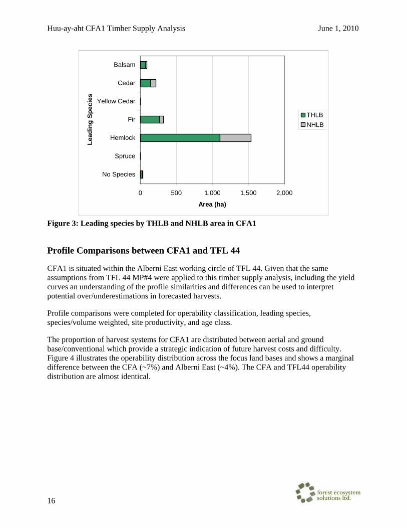
Huu-ay-aht CFA1 Timber Supply Analysis June 1, 2010
16
0 500 1,000 1,500 2,000
No Species
Spruce
Hemlock
Fir
Yellow Cedar
Cedar
Balsam
Lead
ing
Spec
ies
Area (ha)
THLBNHLB
Figure 3: Leading species by THLB and NHLB area in CFA1
Profile Comparisons between CFA1 and TFL 44
CFA1 is situated within the Alberni East working circle of TFL 44. Given that the same assumptions from TFL 44 MP#4 were applied to this timber supply analysis, including the yield curves an understanding of the profile similarities and differences can be used to interpret potential over/underestimations in forecasted harvests.
Profile comparisons were completed for operability classification, leading species, species/volume weighted, site productivity, and age class.
The proportion of harvest systems for CFA1 are distributed between aerial and ground base/conventional which provide a strategic indication of future harvest costs and difficulty. Figure 4 illustrates the operability distribution across the focus land bases and shows a marginal difference between the CFA (~7%) and Alberni East (~4%). The CFA and TFL44 operability distribution are almost identical.

Huu-ay-aht CFA1 Timber Supply Analysis June 1, 2010
17
0%
10%
20%
30%
40%
50%
60%
70%
80%
90%
100%
TFL 44 Alberni East CFA 1
Perc
ent o
f TH
LB A
rea
Aerial harvesting
Ground based
Figure 4: Operability/harvest system comparison
Figure 5 presents the age class distribution for CFA1 and the surrounding land bases. CFA1 has a higher proportion of older forests (age classes 8 and 9) than exhibited by Alberni East or TFL 44. Correspondingly the CFA1 land base has slightly less young age classes (and almost no age classes 4, 5, and 6) which corresponds to the previous noted age class distribution imbalance (Figure 2).
0%
10%
20%
30%
40%
50%
60%
70%
80%
90%
100%
TFL 44 A lbern i East CFA 1
Perc
ent o
f TH
LB A
rea
9876543210
Figure 5: Age class comparison

Huu-ay-aht CFA1 Timber Supply Analysis June 1, 2010
18
Overall, the leading species distribution comparison shows that CFA1 has more hemlock leading stands in the THLB and less Douglas-fir, cedar and balsam than Alberni East and TFL 44 (Figure 6). This comparison does not reflect volume contribution so is an indication of leading species only and includes all age classes within the THLB.
0%
10%
20%
30%
40%
50%
60%
70%
80%
90%
100%
TFL 44 Alberni East CFA 1
Perc
ent o
fTH
LB A
rea
No SpeciesSprucePineHemlockDouglas-FirDeciduousYellow CedarCedarBalsam
Figure 6: Leading species comparison
Since the depletions for TFL 44 were not available, the 2001 inventory volumes were used for this comparison. When considering volume proportion by species, illustrates that CFA 1 exhibits a similar overall proportion to TFL 44 while Alberni East contains proportionately less Douglas-fir (5%), slightly more Cedar (3%) and slightly more hemlock and balsam (1%) than CFA1.

Huu-ay-aht CFA1 Timber Supply Analysis June 1, 2010
19
0%
10%
20%
30%
40%
50%
60%
70%
80%
90%
100%
TFL 44 Alberni East CFA 1
Perc
ent o
f TH
LB A
rea
OtherHem/BalDouglas-firCedar
Figure 7: Species volume comparison
Site productivity represents an indication of the growth potential of a stand and is important to understanding the growth and yield of each forest stand. Broad site classes are aggregations of site indices which are categorized into relative categories of productivity: high, good, medium and poor. The site index class categories are described in Table 10.
Table 10: Site Class Categories
Site Index Class Site Index High > 32 Good 26 - 31
Medium 20 - 25 Poor 11 - 19
Figure 8 shows that CFA 1 THLB exhibits a higher proportion of medium site area than Alberni East and TFL 44, and a lower proportion of high and good productivity sites.

Huu-ay-aht CFA1 Timber Supply Analysis June 1, 2010
20
0%
10%
20%
30%
40%
50%
60%
70%
80%
90%
100%
T F L 44 A lbe rn i E ast C F A 1
Perc
ent o
f TH
LB A
rea
H ighG oodM ed iumP oo r
Figure 8: Site productivity comparison

Huu-ay-aht CFA1 Timber Supply Analysis June 1, 2010
21
Management Objectives
This section provides describes the resource emphases area management objectives that were applied to the CFA including additional information where modeling methods differed from MP No. 4 or required clarification due to ambiguities in the MP No. 4 information package.
Integrated resource management
Green-up requirements were modeled for Special (SMZ) and Enhanced (EMZ) management zones. The majority of CFA1 is within the Sarita EMZ.
Table 11: RMZ targets within CFA1
RMZ CFLB Area (ha)
THLB Area (ha)
Young Disturbance
(maximum %)
Max. age considered
young Enhanced, Klanawa 2 2 25% 5Enhanced, Sarita 2,204 1,613 25% 5
Visual quality objectives
Visual quality objectives were applied as specified in the MP No. 4 information package, with the following exceptions. Visual polygons were constrained directly using the visually effective green-up height of 5 meters, rather than translating this height to a green-up age as was done in MP No. 4. This approach is considerably easier to apply during model loading. Sliver polygons less than 10ha in size were eliminated from the visual inventory. Visual constraints were applied to individual visual polygons, which is consistent with the approach in MP No. 4 analysis. Table 12 displays a summary of the THLB and NHLB areas in the two recommended visual quality classes for the CFAs.
Table 12: Summary of VQO by THLB and NHLB area in CFA1
RVQC THLB Area (ha) NHLB Area (ha)No VQO 1,047 357
M 211 108 PR 357 127
Coastal watershed assessment procedures (CWAP)
CWAP recommendations include maximum harvest rates within specified watersheds and were intended to be applied for the first 10 years of the analysis. CFA1 does not contain any watersheds where CWAP analyses were performed.
Landscape Biodiversity
In the MP 4 analysis, landscape biodiversity objectives were applied as seral forest objectives in accordance with the Landscape Unit Planning Guide. Since that analysis, draft OGMAs have

Huu-ay-aht CFA1 Timber Supply Analysis June 1, 2010
22
been introduced. The draft OGMAs replace the aspatial targets in the CFA base case analysis, and old forest objectives were run as a sensitivity since the draft OGMAs only satisfied approximately 1/3 of the full old seral target.
Old Growth Management Areas
The CFA analysis used draft OGMAs applied as a land base netdown, to account for old forest objectives. The area of the draft OGMAs is detailed in Table 13.
Table 13: Old Growth Management Area distribution in CFA1
OGMA Area (ha) NHLB Area
(ha) THLB Area
(ha) Outside of OGMA 2,212 461 1,615 OGMA 134 131 0
Old Forest Objectives
Old forest objectives are applied by BEC variant / landscape unit. BEC variants were derived from the Terrestrial Ecosystem Mapping for TFL44 and the provincial Abec coverage was used to fill some small gaps in the terrestrial ecosystem mapping. Most of CFA 1 is within the low biodiversity emphasis option (BEO) Sarita landscape units, while a small area is within the intermediate Klanawa landscape unit (Table 14). The full old seral constraint will be tested as a sensitivity analysis for CFA1.
Table 14: Old Seral Targets
BEO, LU, BEC CFLB Area (ha)
THLB Area (ha)
Old Seral Constraint
(minimum %)(1)
Intermediate, Klanawa, CWHvm2 2.3 2.0 13%Low, Sarita, CWHvh1 2.5 2.2 13%Low, Sarita, CWHvm1 1745.1 1288.5 13%Low, Sarita, CWHvm2 456.9 322.5 13%(1) In the low BEO units the requirement is to achieve one third of the target now and to meet the full target by the end of three rotations.
Carnation Creek Deferral
The Carnation Creek watershed has been part of studies to determine the impact of forest harvesting practices on streams and fish since the 1970’s. The control area falls within CFA1 (116.4 ha THLB) and is deferred from harvesting until 2056. The remainder of the watershed is eligible for harvest but it is understood that proposed harvest within the watershed will be subject to discussion between Huu-ay-aht and project researchers.

Huu-ay-aht CFA1 Timber Supply Analysis June 1, 2010
23
Management Assumptions - Harvesting Rules
The timber supply modeling utilized 5-year periods beginning in 2001. Reporting started from the second period (years 2006 to 2010). No harvesting is scheduled for the first period, apart from accounting existing depletions. Additionally, a significant portion of the harvest from 2006-2009 was based on existing depletions or proposed harvest blocks.
Minimum Merchantability Criteria
Minimum merchantability criteria define when a stand is eligible for harvest within the timber supply model. Regenerated stands are considered eligible for harvest when they are 35 years old or when they have attained a minimum volume of 350 m3/ha, whichever is more constraining. All existing mature stands in the THLB are eligible for harvest at an age of 200 years, even if the volume is below 350 m3/ha at age 200.
Harvest Scheduling Rules
Simulation models require harvest-scheduling rules to control the order in which stands are harvested. To understand the impacts of the timber supply assumptions and constraints, it is important that these rules are able to organize harvest in a transparent and logical way that also reflects current management.
Relative oldest first was used in the CFA analysis which queues stands for harvest based on their age relative to its minimum harvest age and sorting from largest to smallest.
Harvest Flow Rules
Harvest flow rules specify the ways in which the total amount of harvest is allowed to vary over the planning horizon.
The CFA analysis set an even flow harvest level (after the first period) to determine the maximum sustainable long-term harvest for the land base. The harvest level selected was based on testing various harvest levels to ensure that no timber supply crashes occurred and that the long-term growing stock was allowed to level off rather than show a declining trend. If possible the short-term harvest level was increased if it did not jeopardize the long-term harvest level.
Unsalvaged Losses
Fire, insects, disease and other factors can cause losses to the growing stock on a land base and reduce the recoverable volume that can be harvested. Losses to merchantable stands may be salvaged. During timber supply modelling, unsalvaged losses are typically added to the modeled harvest level, but removed from the reported harvest level.
In the TFL 44 MP No. 4 Information Package, it was reported that losses to fire, insects and disease were minimal over the land base. Losses to windthrow amounted to 2.8% of the harvested area. It is expected that with improved management to reduce windthrow and salvage of disturbed areas the unsalvaged losses will be less than 1% of the harvest volume. For the CFA

Huu-ay-aht CFA1 Timber Supply Analysis June 1, 2010
24
analysis, an allowance of 1% of the harvest volume is made for unsalvaged losses. All volumes reported are net of unsalvaged losses.

Huu-ay-aht CFA1 Timber Supply Analysis June 1, 2010
25
Growth and Yield
Analysis Units
Analysis Units were specified by Weyerhaeuser in the MP No. 4 Forest Cover Inventory (Field names: [YTCURVE] for existing and [YTCURVE_SE] for regenerated stands). These analysis units specify the species association, stand origin, base yield table, site group, and stewardship zone. This information is used to assign yield tables to the forest stands and to apply operational adjustment factors to the yield tables.
Analysis units were grouped into two species associations:
• Douglas-fir: where the primary species is Douglas-fir, cypress, or pine • Hemlock: where the primary species is Western hemlock, Mountain hemlock, Sitka
spruce, true fir or Western red cedar.
Four site groups (base on site index) were used to further group the inventory stands into analysis units:
• High: >= 32m • Good: 26 m to 31 m • Medium: 20 m to 25 m • Poor: 11 to 19 m
Weyerhaeuser BC Coastal Group’s biophysical site index model (BSIM) was used to assign site index to each forest inventory stand. This model used species, biogeoclimatic variant and geographic location to assign site index for the leading species of a stand. Weyerhaeuser applied the BSIM model to the MP No. 4 Forest Cover Inventory.
Inventory site indexes were used where a cruise had been undertaken, and BSIM site index was used otherwise. All future, regenerating analysis units used the BSIM site index (Table 15).
Table 15: Average (THLB area weighted) BSIM site index for CFA1 CFA1 Site Group
Douglas-fir HemlockHigh 36.1 33.1Good 30.0 28.8Medium N/A 22.6Poor N/A 17.7
The MP No. 4 analysis assigned stands to the prepared yield tables (Table 16) based on stand origin and other inventory attributes. Existing stands that were cruised were assigned to the nearest yield table based on their species association and density. Cruised stands were usually older than 31 years at the time of being cruised. Uncruised stands established before 1962 were assigned to the f7 and h7a yield tables. Uncruised stands established after 1962 were assigned to

Huu-ay-aht CFA1 Timber Supply Analysis June 1, 2010
26
one of the regeneration analysis units based on their biogeoclimatic variant (as described in Table 8.4 of the TFL 44 MP No. 4 Information Package).
For regenerated stands, the regeneration analysis unit was assigned based on stewardship zone and biogeoclimatic variant as described in Tables 8.4 to 8.6 of the TFL 44 MP No. 4 Information Package. Less stands are assigned to the planted yield tables in the habitat and old-growth stewardship zones, compared to the timber zone, and correspondingly, the habitat and old-growth zones assume more natural regeneration.
Table 16: Regeneration yield tables used in the analysis, from Table 8.2 of the Timber Supply Analysis Information Package for Tree Farm Licence 44: Management Plan No. 4
Species Association
Yield Table ID
No. of Planted Stems per ha
No. of Natural Stems per ha
Percent Survival Planted
Percent Distribution
Natural
Regen Lag
(natural)
Years of Natural Regen
Is Regen.
AU
f1a 1200 500 85 60 0 4 Y f8 300 50 0 4 f4 600 70 0 5 Y f5 1500 90 0 5 f6 3000 90 0 5 Y
Douglas-fir
f7 6000 90 0 5 h2 1200 1200 90 75 -2 5 Y h9 300 50 0 5 h5 600 70 0 5 h6 1500 90 0 5 Y h11a 4000 100 0 5 Y
Hemlock
h7a 6000 100 0 5
Figure 9 presents the inventory age classes by analysis unit for CFA1. The analysis unit name is composed of the stewardship zone (first character), species association and yield table id (middle characters) and BSIM site index (last two characters).

Huu-ay-aht CFA1 Timber Supply Analysis June 1, 2010
27
0 100 200 300 400 500
TF1A21
TF1A30
TF1A33
TF1A36
TF1A39
TF636
TF639
TH11A15
TH11A18
TH11A21
TH11A24
TH11A27
TH11A30
TH11A33
TH215
TH218
TH221
TH224
TH227
TH230
TH233
TH239
TH630A
naly
sis
Uni
t (YT
CU
RVE
_SE)
THLB Area (ha)
Age Class 0Age Class 1Age Class 2Age Class 3Age Class 5Age Class 6Age Class 7Age Class 8Age Class 9
Figure 9: Inventory age class distribution by future analysis unit in CFA1
Base Yield Tables
The basic yield tables for the CFA analysis were obtained from Appendix III of the TFL 44 MP No. 4 Information Package. These yield tables were developed with Y-XENO (Weyerhaeuser – now WFP proprietary yield projection model). These tables do not include regeneration delay and adjustment factors for genetic improvement, breakage, decay, non-productive areas, and variable retention. A one-year regeneration delay and operational adjustment factors were applied to appropriate management zones and yield tables in the timber supply model, similar to the approach used in MP No. 4.

Huu-ay-aht CFA1 Timber Supply Analysis June 1, 2010
28
The TFL 44 MP No. 4 Information Package produced yield curves using up to seven different site indexes for each yield curve. The yield curve with the nearest site index to the analysis unit average site index was assigned to the analysis unit for this analysis.
The volume of mature stands, over 125 years old, is assumed to be static, as in the MP4 analysis and previous timber supply analyses. These stands were placed on flatline yield curves based on their forest inventory volume. The mature flatline yield curves were grouped into 20 m3/ha classes.
Silviculture Systems Yield curve modelling assumed clear-cut harvesting methods. Variable retention silviculture systems were modeled using OAFs described in Table 18. Utilization Levels
Utilization levels used when generating yield curves are described in Table 17.
Table 17: Utilization level for mature and second growth stands
Minimum dbh (cm)
Stump height (cm)
Top dib (cm)
Mature 22.5 30 15Second Growth 12.5 30 10
Operational adjustment factors
The base yield tables are modified using several operational adjustment factors, depending on stand origin, regeneration method, stewardship zone, and base species of the yield table. A roll-up of these operational adjustment factors was provided by WFP and is summarized Table 18 and Table 19. These factors were applied to the base yield tables within the timber supply model. Further information about these reductions can be found in the TFL 44 MP No. 4 Information Package. Table 18: Summary of existing stands operational adjustment factors
Stand Origin Base G&Y Species
Waste & Breakage
Insects & Disease
NP & Misc. Adjustments Total OAF
Fd 0.95 0.98 0.9310 Cruised second-growth <1962 (establishment year) Hw 0.935 0.98 0.9163
Fd 0.95 0.98 0.89 0.8286 Uncruised second-growth <1962 Hw 0.935 0.98 0.81 0.7422
Fd 0.95 0.98 0.95 0.8845 Uncruised second-growth >=1962 Hw 0.935 0.98 0.95 0.8705
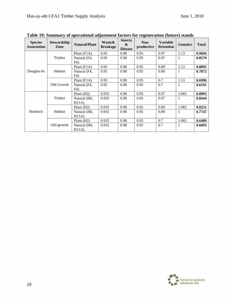
Huu-ay-aht CFA1 Timber Supply Analysis June 1, 2010
29
Table 19: Summary of operational adjustment factors for regeneration (future) stands
Species Association
Stewardship Zone Natural/Plant Waste&
Breakage
Insects &
Disease
Non-productive
Variable Retention Genetics Total
Plant (F1A) 0.95 0.98 0.95 0.97 1.13 0.9694 Timber Natural (F4,
F6) 0.95 0.98 0.95 0.97 1 0.8579
Plant (F1A) 0.95 0.98 0.95 0.89 1.13 0.8895 Habitat Natural (F4,
F6) 0.95 0.98 0.95 0.89 1 0.7872
Plant (F1A) 0.95 0.98 0.95 0.7 1.13 0.6996
Douglas-fir
Old Growth Natural (F4, F6)
0.95 0.98 0.95 0.7 1 0.6191
Plant (H2) 0.935 0.98 0.95 0.97 1.065 0.8993 Timber Natural (H6,
H11A) 0.935 0.98 0.95 0.97 1 0.8444
Plant (H2) 0.935 0.98 0.95 0.89 1.065 0.8251 Habitat Natural (H6,
H11A) 0.935 0.98 0.95 0.89 1 0.7747
Plant (H2) 0.935 0.98 0.95 0.7 1.065 0.6489
Hemlock
Old-growth Natural (H6, H11A)
0.935 0.98 0.95 0.7 1 0.6093

Huu-ay-aht CFA1 Timber Supply Analysis June 1, 2010
30
Results
The harvest forecast graphs presented in this section describe the projected timber flow for a planning horizon of 250 years from 2006. All forecasts were run to 400 years to ensure there were no significant declines in growing stock or pinch points. Harvest forecasts presented are shown as net of non-recoverable losses. In timber supply analysis fluctuations in forecasted harvest volume can occur as a function of the spatial model harvesting entire polygons. In a given period, to meet the volume target the model will attempt to harvest enough polygons until the target is met. If the next selected polygon has more volume than is required the entire polygon is considered harvested, resulting in an increase in harvested volume over the requested level. The results presented in this report have been averaged to facilitate comparison between the base case and sensitivity analyses. The objective of the analysis was at a minimum, meet the short-term harvest of 16,992 m3
per year and maintain a sustainable growing stock over time.
CFA 1 Preliminary Harvest Forecasts
The CFA 1 area is able to support an increased short term harvest of approximately 18,828 m3/yr for the first 25 years of the forecast (2006 to 2030), before dropping to a long term harvest level of 15,766 m3/yr (Figure 10). The long term harvest is 86.4 % of the 18,257 m3/yr LRSY.
0
2,000
4,000
6,000
8,000
10,000
12,000
14,000
16,000
18,000
20,000
0 50 100 150 200 250
Years from 2006
Fore
cast
ed H
arve
st(m
3/yr
)
Max short-termMax short-term step-downTarget AAC
Figure 10: Preliminary harvest forecasts
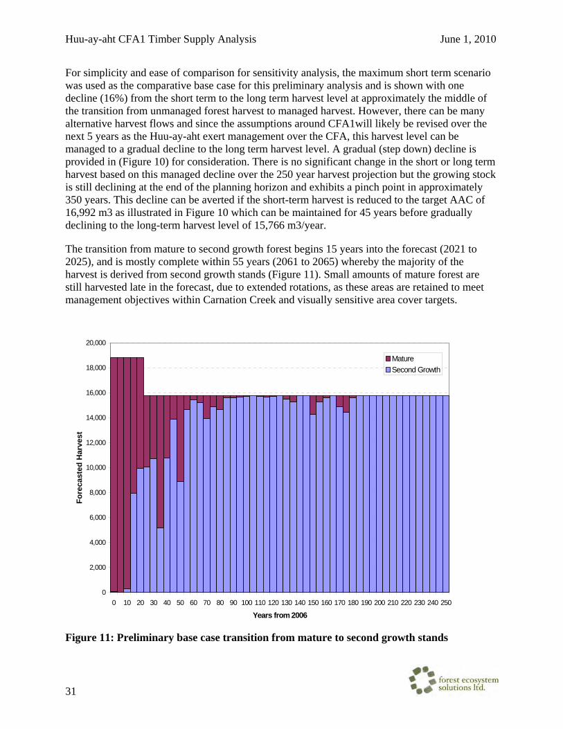
Huu-ay-aht CFA1 Timber Supply Analysis June 1, 2010
31
For simplicity and ease of comparison for sensitivity analysis, the maximum short term scenario was used as the comparative base case for this preliminary analysis and is shown with one decline (16%) from the short term to the long term harvest level at approximately the middle of the transition from unmanaged forest harvest to managed harvest. However, there can be many alternative harvest flows and since the assumptions around CFA1will likely be revised over the next 5 years as the Huu-ay-aht exert management over the CFA, this harvest level can be managed to a gradual decline to the long term harvest level. A gradual (step down) decline is provided in (Figure 10) for consideration. There is no significant change in the short or long term harvest based on this managed decline over the 250 year harvest projection but the growing stock is still declining at the end of the planning horizon and exhibits a pinch point in approximately 350 years. This decline can be averted if the short-term harvest is reduced to the target AAC of 16,992 m3 as illustrated in Figure 10 which can be maintained for 45 years before gradually declining to the long-term harvest level of 15,766 m3/year.
The transition from mature to second growth forest begins 15 years into the forecast (2021 to 2025), and is mostly complete within 55 years (2061 to 2065) whereby the majority of the harvest is derived from second growth stands (Figure 11). Small amounts of mature forest are still harvested late in the forecast, due to extended rotations, as these areas are retained to meet management objectives within Carnation Creek and visually sensitive area cover targets.
0
2,000
4,000
6,000
8,000
10,000
12,000
14,000
16,000
18,000
20,000
0 10 20 30 40 50 60 70 80 90 100 110 120 130 140 150 160 170 180 190 200 210 220 230 240 250
Years from 2006
Fore
cast
ed H
arve
st
MatureSecond Growth
Figure 11: Preliminary base case transition from mature to second growth stands

Huu-ay-aht CFA1 Timber Supply Analysis June 1, 2010
32
The alternative harvest forecasts growing stock are illustrated in Figure 12. The total growing stock at the end of the planning horizon is relatively stable for the max short-term and target AAC scenarios while the step-down scenario is in a declining trend. Each scenario exhibits a similar trend of decline over the first 85 years of approximately 33% from 750,000 m3 to on average approximately 500,000 m3 which from there for the max short-term and the target AAC is maintained or increased and for the max short-term with step down declines further to the end of the planning horizon.
0
100,000
200,000
300,000
400,000
500,000
600,000
700,000
800,000
0 50 100 150 200 250
Years from 2006
Fore
cast
ed T
otal
Gro
win
g St
ock
(m3)
Max short-termMax short-term step downTarget AAC
Figure 12: Alternative harvest forecasts growing stock The annual harvest area (Figure 13) is another indicator of a sustainable harvest level. The long-term harvest level would be unsustainable if the annual area harvested was showing a predominant increasing trend over time. The forecasted annual average area harvested over the planning horizon varies mostly within the range of 20-30 ha per year for the CFA 1 preliminary base case.

Huu-ay-aht CFA1 Timber Supply Analysis June 1, 2010
33
0
5
10
15
20
25
30
35
0 50 100 150 200 250
Years from 2006
Fore
cast
ed A
nnua
l Har
vest
Are
a (h
a)
Figure 13: Base case annual harvest area
Figure 14 displays the temporal snapshots illustrating the changes in the CFA1 age class distribution for the base case analysis. Each chart shows the NHLB and THLB age class for a given point in time in the future. Note that the NHLB area only represents the 100% netdown reductions and partial reductions are not factored in.
The overall trend is a reduction in the amount of old forest >250 years throughout the planning horizon. In 2006, there is approximately 560 ha of old forest in the CFA1 THLB (155 ha in NHLB) and within 100 years this is reduced to approximately 55 ha resulting in a mostly normal distribution as all harvesting is occurring from second growth stands. Natural disturbance in the NHLB is not modeled in this analysis, which leads to the NHLB area remaining old throughout the entire planning horizon, which is consistent with the assumption used in MP4.
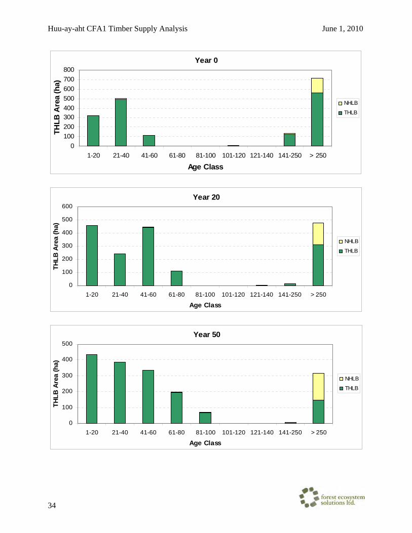
Huu-ay-aht CFA1 Timber Supply Analysis June 1, 2010
34
Year 0
0100200300400500600700800
1-20 21-40 41-60 61-80 81-100 101-120 121-140 141-250 > 250
Age Class
THLB
Are
a (h
a)
NHLB
THLB
Year 20
0
100
200
300
400
500
600
1-20 21-40 41-60 61-80 81-100 101-120 121-140 141-250 > 250
Age Class
THLB
Are
a (h
a)
NHLB
THLB
Year 50
0
100
200
300
400
500
1-20 21-40 41-60 61-80 81-100 101-120 121-140 141-250 > 250
Age Class
THLB
Are
a (h
a)
NHLB
THLB

Huu-ay-aht CFA1 Timber Supply Analysis June 1, 2010
35
Year 100
0
100
200
300
400
500
1-20 21-40 41-60 61-80 81-100 101-120 121-140 141-250 > 250
Age Class
THLB
Are
a (h
a)
NHLB
THLB
Year 150
0
100
200
300
400
500
600
1-20 21-40 41-60 61-80 81-100 101-120 121-140 141-250 > 250
Age Class
THLB
Are
a (h
a)
NHLB
THLB
Year 200
0
100
200
300
400
500
1-20 21-40 41-60 61-80 81-100 101-120 121-140 141-250 > 250
Age Class
THLB
Are
a (h
a)
NHLB
THLB

Huu-ay-aht CFA1 Timber Supply Analysis June 1, 2010
36
Year 250
0
100
200
300
400
500
1-20 21-40 41-60 61-80 81-100 101-120 121-140 141-250 > 250
Age Class
THLB
Are
a (h
a)
NHLB
THLB
Figure 14: Base case age class distributions
Figure 15 illustrates the average harvest age for CFA1 over the planning horizon, as the harvest transitions from older unmanaged forest stands to second growth managed stands resulting in a decreasing average harvest age over time. This trend is occurring in CFA1 where the average harvest age declines from over 300 years to 150 years within the first 25 years of the forecast. After the transition to harvesting second growth stands is completed, the harvest then predominantly relies on age class 4 stands, as shown in Figure 16.

Huu-ay-aht CFA1 Timber Supply Analysis June 1, 2010
37
0
50
100
150
200
250
300
350
400
0 50 100 150 200 250
Years from 2006
Fore
cast
ed A
vera
ge H
arve
st A
ge (y
rs)
Figure 15: Base case average forecasted harvest age
0
2,000
4,000
6,000
8,000
10,000
12,000
14,000
16,000
18,000
20,000
0 10 20 30 40 50 60 70 80 90 100 110 120 130 140 150 160 170 180 190 200 210 220 230 240 250
Years from 2006
Fore
cast
ed H
arve
st (m
3/yr
)
> 250141-250121-140101-12081-10061-8041-6021-401-20
Figure 16: Base case harvest by age class

Huu-ay-aht CFA1 Timber Supply Analysis June 1, 2010
38
Figure 17 and Figure 18 display the average harvest volume and harvest volume by volume class for the CFA 1 base case. As illustrated in Figure 17, for the most part the average harvest volume is maintained above 700m3/ha throughout the entire planning horizon. This is supported by Figure 18 which shows only a small portion of the CFA1 predicted harvest that is expected to be below 700-800 m3/ha category.
0
200
400
600
800
1,000
1,200
0 50 100 150 200 250
Years from 2006
Fore
cast
ed A
vera
ge H
arve
st V
olum
e / H
a
Figure 17: Base case average forecast harvest volume

Huu-ay-aht CFA1 Timber Supply Analysis June 1, 2010
39
0
2,000
4,000
6,000
8,000
10,000
12,000
14,000
16,000
18,000
20,000
0 10 20 30 40 50 60 70 80 90 100 110 120 130 140 150 160 170 180 190 200 210 220 230 240 250
Years from 2006
Fore
cast
ed H
arve
st (m
3/yr
)
1500-17001300-15001100-1300900-1100700-900500-700300-500
Figure 18: Base case, estimated harvest by volume class
CFA 1 Old Seral Forest Sensitivity
The base case analysis utilized draft OGMAs but did not apply any additional non-spatial old seral objectives to meet full old seral forest targets. The old forest sensitivity analysis applies aspatial old seral targets (Table 14), whereas the base case harvest forecast used draft OGMAs as applied in the netdown to meet old seral objectives. The majority of CFA 1 is within low BEO units and the practice is to meet one third of the target now and the full old seral target after three rotations.
This sensitivity analysis supports the long-term harvest projection in that the inclusion of the full old seral targets does not impact the base case harvest level in CFA 1. The forecast harvest level is unchanged from the base case (Figure 19) and the growing stock follows the same trajectory (Figure 20) though slightly lower than in the base case. As expected, the harvest transition from existing mature stands (Figure 19) occurs earlier in the future than for the base case (Figure 11) due to retention of the old forest. Additionally, older stands that were harvested later in the planning horizon in the base case are now retained to meet the old seral objectives.
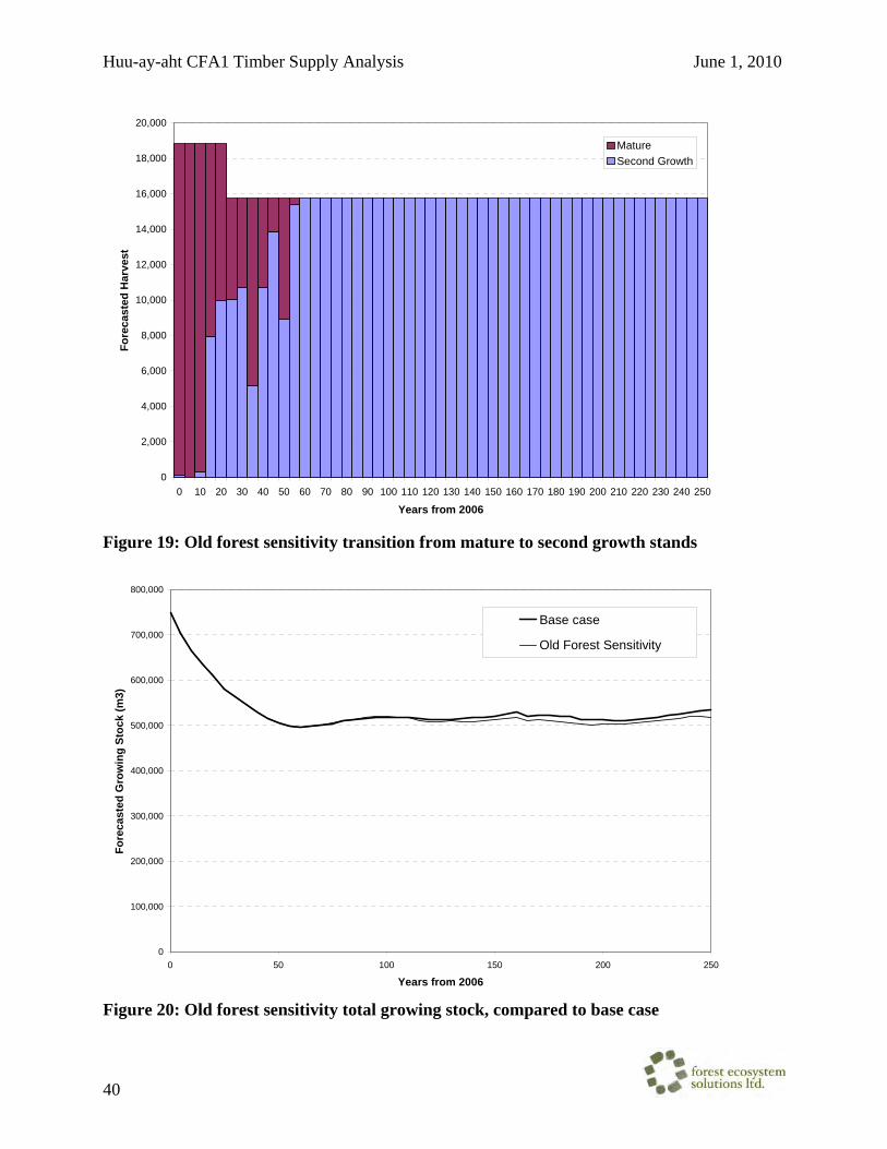
Huu-ay-aht CFA1 Timber Supply Analysis June 1, 2010
40
0
2,000
4,000
6,000
8,000
10,000
12,000
14,000
16,000
18,000
20,000
0 10 20 30 40 50 60 70 80 90 100 110 120 130 140 150 160 170 180 190 200 210 220 230 240 250
Years from 2006
Fore
cast
ed H
arve
st
MatureSecond Growth
Figure 19: Old forest sensitivity transition from mature to second growth stands
0
100,000
200,000
300,000
400,000
500,000
600,000
700,000
800,000
0 50 100 150 200 250
Years from 2006
Fore
cast
ed G
row
ing
Stoc
k (m
3)
Base case
Old Forest Sensitivity
Figure 20: Old forest sensitivity total growing stock, compared to base case
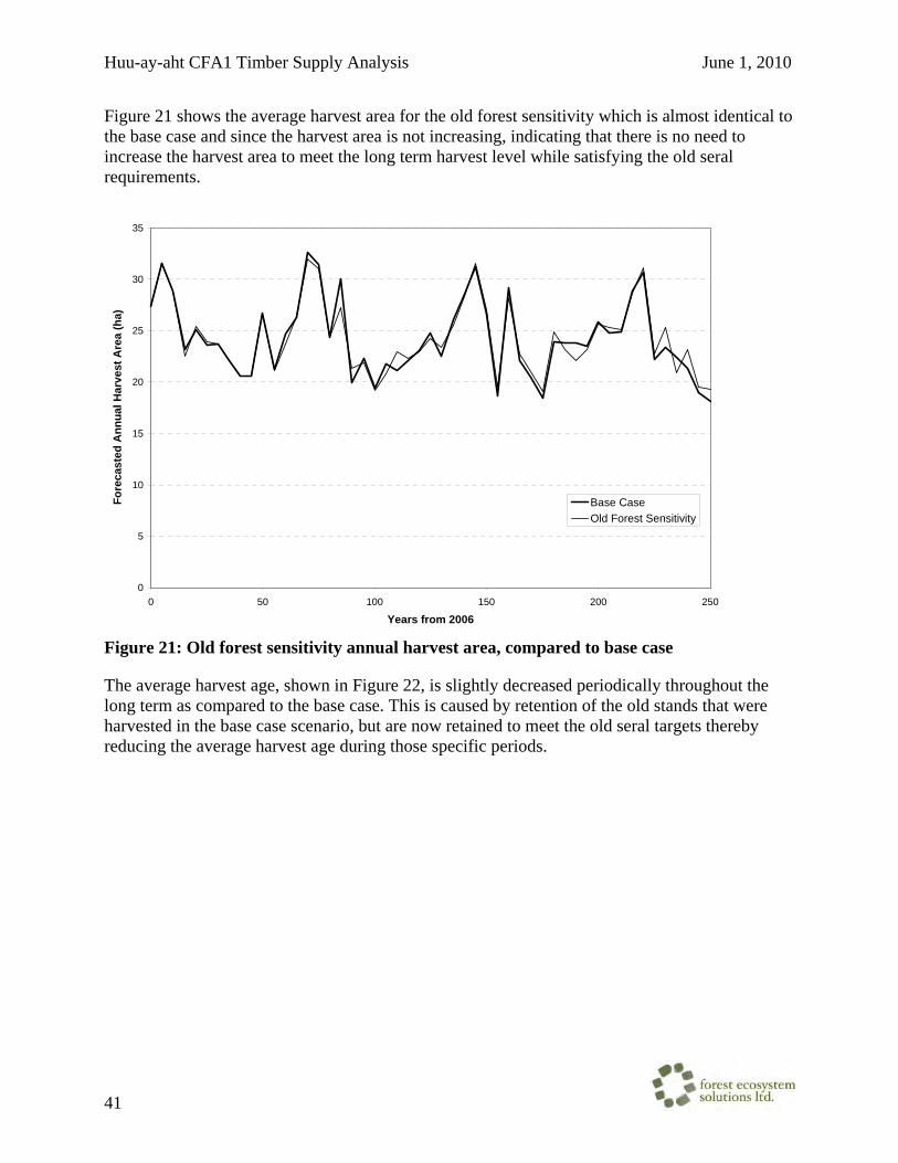
Huu-ay-aht CFA1 Timber Supply Analysis June 1, 2010
41
Figure 21 shows the average harvest area for the old forest sensitivity which is almost identical to the base case and since the harvest area is not increasing, indicating that there is no need to increase the harvest area to meet the long term harvest level while satisfying the old seral requirements.
0
5
10
15
20
25
30
35
0 50 100 150 200 250
Years from 2006
Fore
cast
ed A
nnua
l Har
vest
Are
a (h
a)
Base CaseOld Forest Sensitivity
Figure 21: Old forest sensitivity annual harvest area, compared to base case
The average harvest age, shown in Figure 22, is slightly decreased periodically throughout the long term as compared to the base case. This is caused by retention of the old stands that were harvested in the base case scenario, but are now retained to meet the old seral targets thereby reducing the average harvest age during those specific periods.
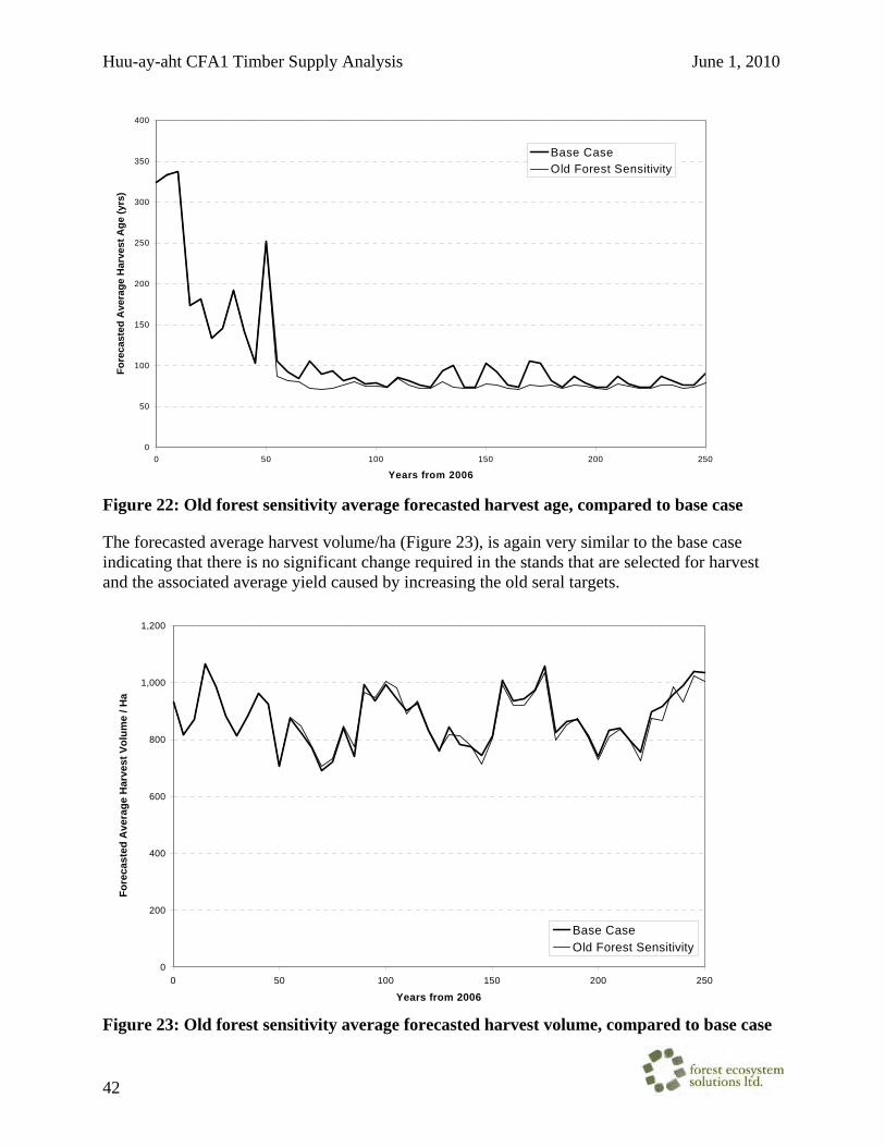
Huu-ay-aht CFA1 Timber Supply Analysis June 1, 2010
42
0
50
100
150
200
250
300
350
400
0 50 100 150 200 250
Years from 2006
Fore
cast
ed A
vera
ge H
arve
st A
ge (y
rs)
Base CaseOld Forest Sensitivity
Figure 22: Old forest sensitivity average forecasted harvest age, compared to base case
The forecasted average harvest volume/ha (Figure 23), is again very similar to the base case indicating that there is no significant change required in the stands that are selected for harvest and the associated average yield caused by increasing the old seral targets.
0
200
400
600
800
1,000
1,200
0 50 100 150 200 250
Years from 2006
Fore
cast
ed A
vera
ge H
arve
st V
olum
e / H
a
Base CaseOld Forest Sensitivity
Figure 23: Old forest sensitivity average forecasted harvest volume, compared to base case

Huu-ay-aht CFA1 Timber Supply Analysis June 1, 2010
43
Figure 24 displays the temporal snapshots illustrating the changes in the CFA1 age class distribution for the old forest sensitivity analysis. Each chart shows the NHLB and THLB age class for a given point in time in the future. Note that the NHLB area only represents the 100% netdown reductions and partial reductions are not factored in.
The overall trend is the same as for the base case, with a reduction of age class 9 forest (> 250 years old) through the planning horizon and a normalizing of the age class distribution. However, compared to the base case analysis, the old forest sensitivity maintains about twice the amount of age class 9 forest within the THLB (95 ha THLB verses 55 ha THLB in the base case). The NHLB remains relatively constant.
Year 0
0100200300400500600700800
1-20 21-40 41-60 61-80 81-100 101-120 121-140 141-250 > 250
Age Class
THLB
Are
a (h
a)
NHLB
THLB
Year 20
0
100
200
300
400
500
600
1-20 21-40 41-60 61-80 81-100 101-120 121-140 141-250 > 250
Age Class
THLB
Are
a (h
a)
NHLB
THLB

Huu-ay-aht CFA1 Timber Supply Analysis June 1, 2010
44
Year 50
0
100
200
300
400
500
1-20 21-40 41-60 61-80 81-100 101-120 121-140 141-250 > 250
Age Class
THLB
Are
a (h
a)
NHLB
THLB
Year 100
0
100
200
300
400
500
1-20 21-40 41-60 61-80 81-100 101-120 121-140 141-250 > 250
Age Class
THLB
Are
a (h
a)
NHLB
THLB
Year 150
0
100
200
300
400
500
600
1-20 21-40 41-60 61-80 81-100 101-120 121-140 141-250 > 250
Age Class
THLB
Are
a (h
a)
NHLB
THLB

Huu-ay-aht CFA1 Timber Supply Analysis June 1, 2010
45
Year 200
0
100
200
300
400
500
1-20 21-40 41-60 61-80 81-100 101-120 121-140 141-250 > 250
Age Class
THLB
Are
a (h
a)
NHLB
THLB
Year 250
0
100
200
300
400
500
1-20 21-40 41-60 61-80 81-100 101-120 121-140 141-250 > 250
Age Class
THLB
Are
a (h
a)
NHLB
THLB
Figure 24: Old forest sensitivity age class distributions
Huu-ay-aht CFA1 Timber Supply Analysis June 1, 2010
46
Conclusion
The Huu-ay-aht Community Forest 1 has a current THLB of 1,618 ha with a merchantable growing stock of approximately 650 thousand cubic meters. Of this volume, approximately 39% are composed of stands that are currently older than 140 years of age. Without considering any limitations or constraints to timber supply, the current merchantable growing stock would allow harvesting of the community forest’s proposed AAC of 16,992 m3
for the next 38 years.
Based on profile comparisons with TFL 44 and Alberni East, CFA 1 exhibit a similar operability and harvest system distribution. In terms of stand ages, CFA 1 has a higher proportion of old forest but also exhibits a more significant age class gap than does the TFL or Alberni East. Based on area weighted by leading species, the CFA has a higher proportion of western hemlock and lower proportions of cedar and Douglas-fir. However, based on species volume, the CFA is similar to TFL44 while Alberni East exhibits a slightly higher proportion of cedar and hemlock/balsam volume and less Douglas-fir volume. The CFA has a higher proportion of moderate sites with less good and high sites than the TFL and Alberni East.
The base case for this analysis is robust in the short term and illustrates a maximum short-term forecasted harvest 10% over the target AAC for approximately the next 20 years. A gradual decline to the long-term can also be achieved, however, there is a continual decline in the growing stock that occurs beyond 250 years. The target AAC of 16,992 m3 can be achieved for almost 45 years with a gradual decline to the long-term harvest level of 15,776 m3/yr. Also, the application of full old growth (non-spatial) biodiversity targets has no measurable impact on mid or long term harvest.

HFN Limited Partnership • Application for a Community Forest Agreement •
HFN Forestry Limited Partnership • www.huuayaht.org • 1–250–728–3080 • [email protected]
Appendix C Trapper Referral Letter and CFA1 Map

Huu-ay-aht First Nation 3483 3rd Ave., Port Alberni, BC V9Y 4E4 Phone: 250.723.0100 Facsimile: 250.723.4646
March 8, 2010
Dear Trap line Licensee: RE: The Huu-ay-aht First Nation Community Forest Agreement Application
The Huu-ay-aht First Nation has been invited to apply for a Community Forest Agreement (CFA) for an Allowable Annual Cut (AAC) of 16,900 m3, and is currently in the process of completing the application requirements. The South Island Forest District, District Manager has provided approval for the Huu-ay-aht CFA1 area. A map of the CFA1 area is attached. The CFA1 application consists of, in part, a Management Plan, Business Plan, and Harvest Rate Estimates. These items shall be placed on our Huu-ay-aht website for public, stakeholder, First Nations, and agency review and comment www.huuayaht.org. The Management Plan is a broad planning document, which incorporates integrated resource management, describes management goals, and states strategies that will be employed to meet these goals. It also lists Higher Level Plans that cover the area, government objectives that apply to the area, and describes methods by which the licence holder will meet these objectives. As well as being posted on our website, the application will be available for viewing at the Huu-ay-aht Treaty Office at 3483 3rd Ave., Port Alberni during regular office hours (from 8:30 am to 4 pm) starting in April. In addition we shall be holding an Open House at the Huu-ay-aht Treaty Office on April 14 at 2:00 pm to present the application highlights and provide the public with an opportunity to review and comment on the application. The deadline for comments on our draft application, including our Management Plan, is May 14, 2010. Please send comments to HFN Forestry Limited Partnership, 3483 3rd Ave., Port Alberni, BC, V9Y 4E4, or e-mail your comments to [email protected]. We look forward to your reply. Sincerely, Paul Dagg, RPF Planning Forester Huu-ay-aht First nation Forestry cc: HFN Chief and Council Rob Botterell, Botterell & Company Steve Gray, General Manager, HFN Forestry Darren Hiller, RFT, DRH Forestry Paul Knowles, District Manager, South Island Forest District Dave Cruickshank, Tenures Forester, South Island Forest District Stan Coleman, RPF, Rocky Point Forest Services Ltd.

962220962221962108
961215
Sarita River
SaritaFalls
Sarita Lake
May Lake
Miller L
Frederick L.
Consinka L
Dewlay Lake
Crown Lake
SP700
BAMFIELD MAIN (BM)
BM5 00
B N200
FL1300SP71 0
BM139
CE278
B M600
BN 300
SP730
FL11
00
BM15
00
BM400
F L 900
SPENCER MAIN (SP)
HC620
HC500
CE266
SP500
BN23 1
BN1 10
HC6 00
CE281
BM16
00
CE248B
HAR
RISON MAIN (HC)
CENTRAL MAIN (CE)
C R 2 00
HC7 00
CE246ABM139D
CE27 7
CR220
CE24
6
SP14 00
FL1200
CE 278A
FLORA MAIN (FL)
CE265
CE13
9
C E248
BN 500
CR222
CE279
B N100
BM120 0
SP510
SP120 0
SP712
SP530
BM 1400
SP1500
SP734
CE2 48A
BM139D5
BM5 50
BN112
SP6 0 0
BN140
VENN MAIN (VE)
C E273
SP735
CE
278C
SP511
SP2100
VE300
S P7 11
BM16
60
SP733DSP2 000
CE18
00
HC10 0
FL1310
BM900
S P732
BLENHE I M MAIN (BN)
HC610
BM1800
FL 1320
S P733
BN117
BN12 0
HC520
FL920
HC 110SP740
HC351
CE285
SP180 0C
FL1000
CR430
SP710P
SP R
SP710G
BM1 39D6
HC300
BM139D1
BM
602
CE242
HC420
CE278
A1
HC114
BM700
SP1420
S P 2 00
HC330
HC 730
BM850
HC400
HC6 40
SP760
BM1500 E
B M1 900
SP1 6 0 0
BM250
SP720
BN700
BM930
FL1210
CE236
HC200
CE246C
SP1100
SPS
B N150
SP736
S P Q
FA1300
HC710
FL1220
BM606
SP14
60
SP100
BM
1820
SP 10 0 0
HC310
BM41
3
BM440
HC11 5
CR230
BM450
SPJ
CE266E
SP1800
S P746
BM139A
BM1560
BM540
C E27 8M
BN141
SP700E
HC530
S P 2300
BM
1620
SP14 40
FL N
SP73
5C
HC 63 0
BN112E
FL1 325
SP1510F
FL 1323
BM530
BM139D4
CE280
SP540
S P3 00 BM510
SP 7 34K
BM5
60
SP13 00
BM139D3
BM10
00
C E278
D
FL900A
HC353
HC132
HC580
CE260
SP62
0
BM54 2
BM561
S P6 99A
BN600
HC120
BN130
HC 111
SPA
SP21
0
BM1100
HCG
BM5 20
SP220
CE24 8D
BNH
BM453
BM
1210
CE20
2H
BNJ
HC740
BM570
BM1610
BNK
CE255
BM139D2
BM
415
CR210
SP1530
CR3 00
HCL
SU100
BM594
CE2 46B
BM59
0
S P8 50
SP711G
SP1 040
FA12
00
SP310
SP701
HC720
S P700D
CE277B
SP2200
CE261
BN400
CE286
CE272
VE200
B M8 00
HC 350
SP180
0A
SP1510H
SP1240
SP1260
SP742
CE 270
BM1500B
FL1110
SP711CA
SP699
FL940
HC116
SP1330
SP 1810
C E1 39G
C E260A
SP734C
SP1700
HCM
CE266C
FL93
0
BM410
BNN
SP1510A
SP2010
FL935
SP7 10R
CR 211
HC220
FL1020
CR240
SP1900
SP152 0
BM1645
FL910
FL1300C
S PB
BM60
5
CE266B
B M6 02A
BM8 50B
FL921
CR320
BN220
CR208
SP730C
BM562
CR221
SP51
1C
FL1240
B M 850A
HC650
F L1 326
HC11
3
SP511A
CE265A
BM15
00E2
CE246D
FL 1 325B1
SP
2340
SP720A
S P750
SPT
BN160H C4 40
SP4 00
VE 6000
FL91
5
SPX
SP738
BM1681
BM801
BM60
3
FAUNA MAIN (FA)
FL92
3
SP710F
CE279C
BM 1670
BM413B
SP1462
BM580
BM551
SP705
BM1930
SP700F
BM601
SP512
CE18
30
SP2110
S P5 90
VE10
0
SP735A
SP733D1
CE27
9B4
SP2040
SP610
FL960
FL90
0E
CR25
2
FL1322
BR139D10
CE27
4
HC550
FL1325D
BN210
SPE
B M1440
CR242
BNA
SP 1020
CR222E
SP2020
SP500A
CE27
8I
SP1
230
CE271
BM192
0
BN116
BM160 0E
BM15
50
VE5000
CE26
6A
CE262
BM92
0
CE284
BM46
0
BN71 0
9642
13-S
P1
S P1470
HC41
0
SPH
BM 545
C E278A8SP
1311
CR22
2G
CE266C1
SP2033
SPP
CE234
BM606A
HC351
F
S P1490
BN80 0
SP1465
SP1060
HC570
SP1242
SP73
1
BM41
5A
SP1422
BM604
CR222L
HC562
CE249B2B
VE300
0
BN720
HC340
CE
202
CR 231
HC300E
HC117
SP1630
SPO
BM1690
SPT2
BM445B
CR200F
BN41
0
SP58
0
BM139D5A
HC611
BNG1
CE266M
SP711CA1
SPP1
CE
202J
CE278A4
FLR
SP737
KM26
00
CE278A6
BM1 500C
SP1421
SP2330
FL1302
SP320
BM535 HC111B
SP2400
BN170
HC30
0A
BM13
9A3
CR225
SP73
4M
BN430CE278E
SP700E1
SP1030
SP710
Q
HC642
FL900B
SP734L
CE139H
HC651BN
112B
SP71
0H SP710L
8689-S
P1
SP240
HC430
SP570SP710G1
BM139D7
BM581
FL1000B
SP712 C
BM454
BM16
12
CE2 50
963104-SP1
SP1800G
CE277B2
FL900F
HC35
3B
VEA
SP2031 SP71
0A1
CE278A3
BM94
0
SP1430
SP1070
BN14
4
CE266K
SP733D8
9634-SP3
HC360
SP1272
BM19
10
SP73
5B
SP733B
HCZ
FL1250
BM139A1
HC313
SP1461
FL13
21
CE266G
HC600A
SP2380
SP74
7ABN131
SP52
0
FL132
3A1
BNM
SP1400D
SP72
1CE279E
CR22
2B
HC733
CE
281A
SP181
1
HC110D
HC521
CE278L
FL130
1
SP710
B
SP105
0
SP33
0
SP1510G
BM54
2A
SPU
CR330
CR22
2N
BM139D11
SP70
3
BM1666
SP743
SP724
HC500K
BM139D5F
CE27
9B1
SP2061
SP702
SP1271
092C.087.3.1
092C.086.3.3 092C.087.3.3092C.086.4.3092C.086.3.4 092C.086.4.4
092C.086.4.2
092C.096.2.1092C.097.1.1092C.096.1.1 092C.096.1.2 092C.096.2.2
092C.097.1.3092C.096.1.3 092C.096.2.3 092C.096.2.4
092C.096.1.4
092C.086.4.1092C.086.3.2092C.086.3.1
092C.096.3.1
092C.096.3.2092C.096.4.1 092C.096.4.2 092C.097.3.1
092C.085.4.4
092C.095.2.2
092C.095.2.4
092C.085.4.2
092C.095.4.2
092C.097.1.4
092C.097.1.2
092C.097.3.2
092C.087.3.4
092C.087.1.3092C.086.2.4 092C.087.1.4
San MateoBay
ALBERNI INLET
NumukamisBay
HUU-AY-AHT COMMUNITY FOREST 1MANAGEMENT PLAN AREA
HFN Traditional Territory
WFP Roads
Proposed Road
Streams
BC Grid 5k
Community Forest 1 Management Plan Area
HFN Blocks Harvested
HFN Blocks Proposed
Oceans and Lakes
LEGEND
©1:50,000
DRH Forestry Consulting3483 3rd AvenuePort Alberni BC
V9Y 4E4Drawn By: B. Bayley
Thursday, June 11, 2009 7:49:13 AMMap Date:
