hurricanes - university of texas at austin · hurricanes are intense tropical cyclones with a ......
TRANSCRIPT
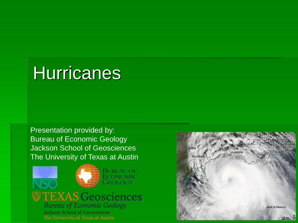
Hurricanes
Presentation provided by:
Bureau of Economic Geology
Jackson School of Geosciences
The University of Texas at Austin

What Is A Hurricane?
Hurricanes are intense tropical cyclones with a
maximum sustained speed of at least 74 mph
Warm core, low-pressure systems that develop in
tropical or subtropical waters (warm water!), and
have organized circulation
Product of warm tropical ocean + warm, moist
atmosphere
Called hurricanes in the Atlantic and Eastern
Pacific, typhoons in the Western Pacific, and
cyclones in the Indian Ocean
Season is from June 1-November 30

Warm air and water vapor rise into the cooler upper atmosphere, become unstable, and create thunderstorms
Warm water provides the heat energy needed for the low pressure to begin to circulate
Warm water=fuel, dissipate over land
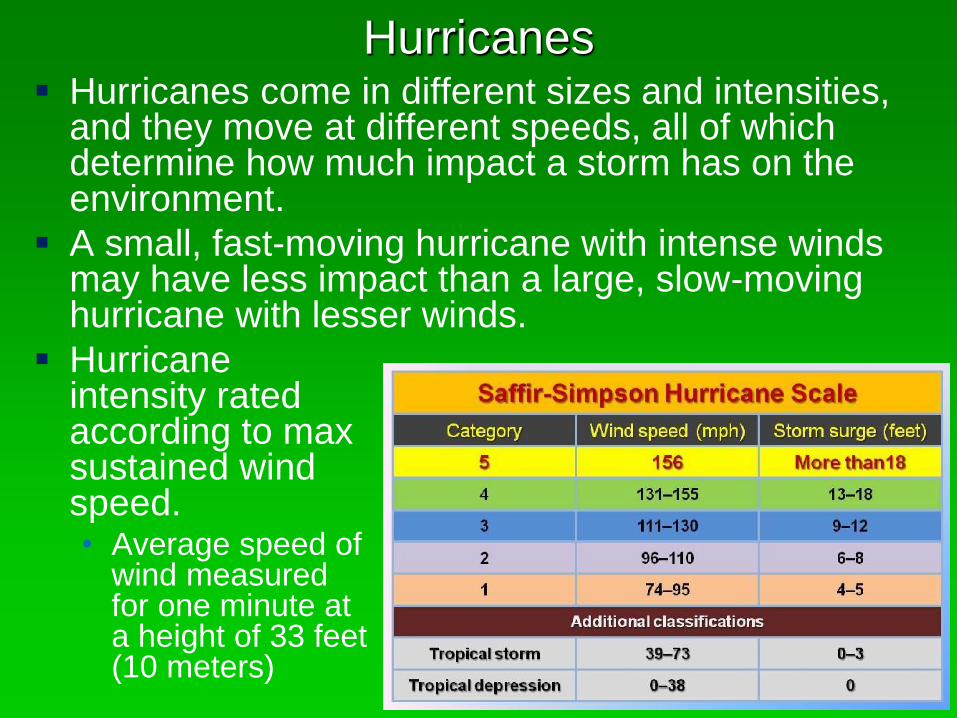
Hurricanes come in different sizes and intensities, and they move at different speeds, all of which determine how much impact a storm has on the environment.
A small, fast-moving hurricane with intense winds may have less impact than a large, slow-moving hurricane with lesser winds.
Hurricanes
Hurricane intensity rated according to max sustained wind speed.• Average speed of
wind measured for one minute at a height of 33 feet (10 meters)
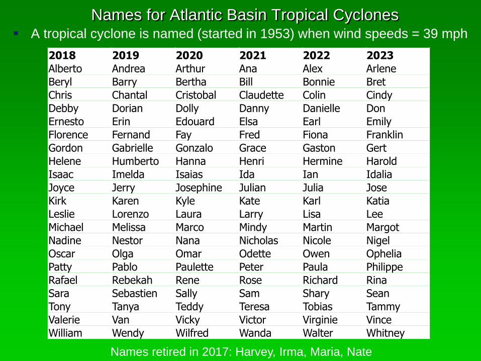
Names for Atlantic Basin Tropical Cyclones A tropical cyclone is named (started in 1953) when wind speeds = 39 mph
2018 2019 2020 2021 2022 2023
Alberto Andrea Arthur Ana Alex Arlene
Beryl Barry Bertha Bill Bonnie Bret
Chris Chantal Cristobal Claudette Colin Cindy
Debby Dorian Dolly Danny Danielle Don
Ernesto Erin Edouard Elsa Earl Emily
Florence Fernand Fay Fred Fiona Franklin
Gordon Gabrielle Gonzalo Grace Gaston Gert
Helene Humberto Hanna Henri Hermine Harold
Isaac Imelda Isaias Ida Ian Idalia
Joyce Jerry Josephine Julian Julia Jose
Kirk Karen Kyle Kate Karl Katia
Leslie Lorenzo Laura Larry Lisa Lee
Michael Melissa Marco Mindy Martin Margot
Nadine Nestor Nana Nicholas Nicole Nigel
Oscar Olga Omar Odette Owen Ophelia
Patty Pablo Paulette Peter Paula Philippe
Rafael Rebekah Rene Rose Richard Rina
Sara Sebastien Sally Sam Shary Sean
Tony Tanya Teddy Teresa Tobias Tammy
Valerie Van Vicky Victor Virginie Vince
William Wendy Wilfred Wanda Walter Whitney
Names retired in 2017: Harvey, Irma, Maria, Nate

Hurricanes as Geologic Agents
Wind
• Wind is NOT a major geologic agent because wet
sand is hard to move
Storm surge
• Storm surge is a major geologic agent as it
transports large amounts of sediment
Waves
• Waves are a major geologic agent because of
their erosive powers
Rainfall
• Rain is a major geologic agent because extensive
flooding causes erosion.
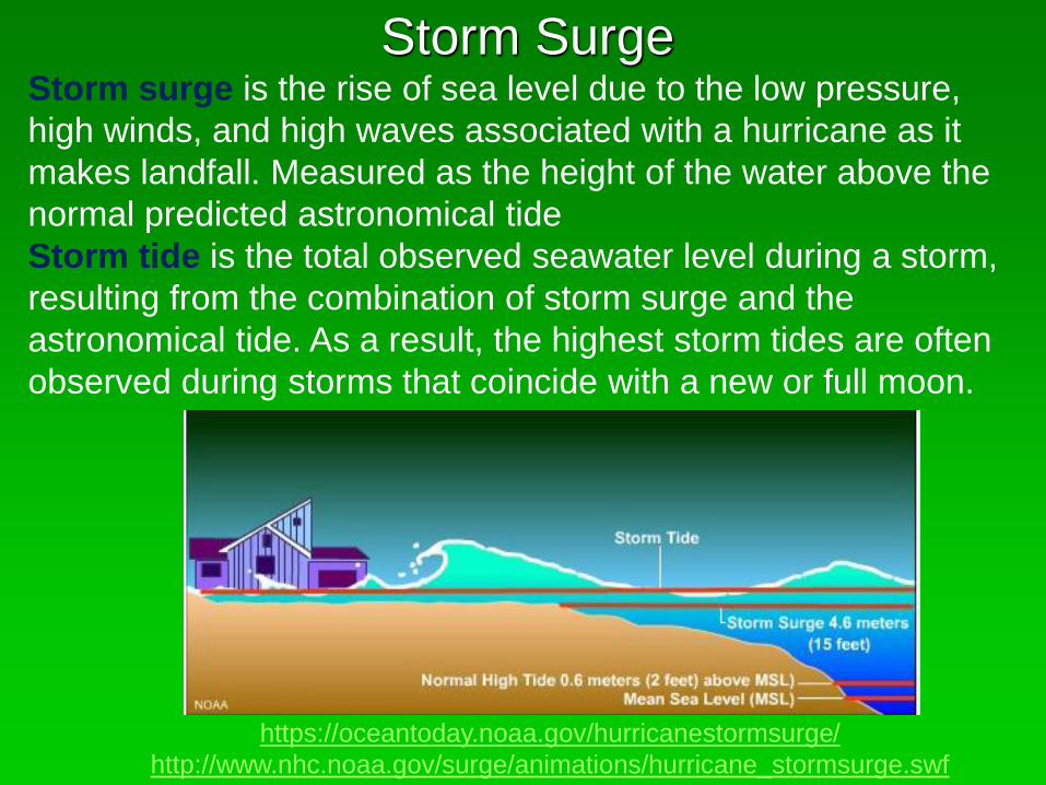
Storm SurgeStorm surge is the rise of sea level due to the low pressure,
high winds, and high waves associated with a hurricane as it
makes landfall. Measured as the height of the water above the
normal predicted astronomical tide
Storm tide is the total observed seawater level during a storm,
resulting from the combination of storm surge and the
astronomical tide. As a result, the highest storm tides are often
observed during storms that coincide with a new or full moon.
https://oceantoday.noaa.gov/hurricanestormsurge/
http://www.nhc.noaa.gov/surge/animations/hurricane_stormsurge.swf
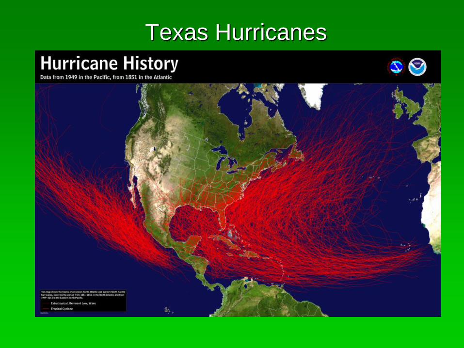
Texas Hurricanes

Hurricane Ike 2008

Hurricane Ike 2008 Category 2 storm that made landfall on
Bolivar Peninsula on September 13,
2008.
Maximum wind speed at landfall was 110
mph. Max wind speed during the storm
was 144 mph while in the Atlantic Ocean.
Storm surge estimated at 15-20 feet on
Bolivar Peninsula.
Due to its immense size, Ike
caused devastation from the
Louisiana coastline all the way
to the Kenedy County region
south of Corpus Christi, Texas.
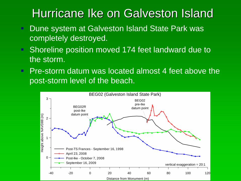
Hurricane Ike on Galveston Island Dune system at Galveston Island State Park was
completely destroyed.
Shoreline position moved 174 feet landward due to
the storm.
Pre-storm datum was located almost 4 feet above the
post-storm level of the beach.
-40 -20 0 20 40 60 80 100 120
Distance from Monument (m)
0
1
2
3
He
igh
t a
bo
ve
NA
VD
88
(m
)
Post-TS Frances - September 16, 1998
April 23, 2008
Post-Ike - October 7, 2008
September 16, 2009vertical exaggeration = 20:1
BEG02 (Galveston Island State Park)
BEG02
pre-Ikedatum pointBEG02R
post-Ikedatum point
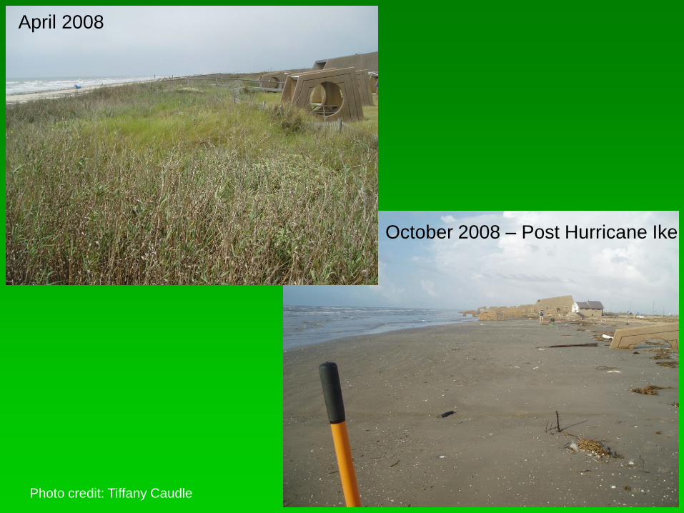
October 2008 – Post Hurricane Ike
April 2008
Photo credit: Tiffany Caudle

Photo credit: Tiffany Caudle