hurricane ana · 2019-06-06 · hurricane ana 3 remained until 0300 utc 21 october. the last...
TRANSCRIPT
1
CENTRAL PACIFIC HURRICANE CENTER TROPICAL CYCLONE REPORT
HURRICANE ANA (CP022014) 13 – 26 October 2014
Jeff Powell Central Pacific Hurricane Center
17 July 2015
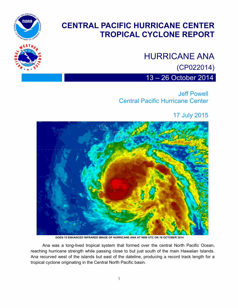
GOES-15 ENHANCED INFRARED IMAGE OF HURRICANE ANA AT 0600 UTC ON 18 OCTOBER 2014
Ana was a long-lived tropical system that formed over the central North Pacific Ocean,
reaching hurricane strength while passing close to but just south of the main Hawaiian Islands.
Ana recurved west of the islands but east of the dateline, producing a record track length for a
tropical cyclone originating in the Central North Pacific basin.

HURRICANE ANA 2
HURRICANE ANA
13 – 26 OCTOBER 2014
SYNOPTIC HISTORY
The circulation which eventually became Hurricane Ana formed within an area of intense but
disorganized deep convection from 07N to 14N east of 145W which had been persistent for at least a
week through mid-October. This convection also flourished along the southeast flank of an upper low
about 800 miles to the west northwest. Flooding rainfall triggered by this preceding upper low occurred
across portions of the main Hawaiian Islands several days before these islands felt the effects of Ana.
The Central Pacific Hurricane Center (CPHC) first recognized potential for development east of 145W, in
coordination with the National Hurricane Center (NHC), in its 0000 UTC 12 October Tropical Weather
Outlook. Convection become rapidly more organized over the next 36 hours, prompting the CPHC to
issue bulletins on Tropical Depression 02C at 2100 UTC 13 October. Convection continued to organize
rapidly and this system was upgraded to Tropical Storm Ana at 0300 UTC 14 October. This is the first
name that appears on the Central North Pacific storm names list number four, the first time this particular
list has been used. A cold front had pushed south of 30N between 150W and 170W, weakening the
subtropical ridge across much of the Central North Pacific. This allowed Ana to gain latitude as deep
steering flow pushed this system toward the west. CPHC issued its first tropical storm watch for the main
Hawaiian Islands, initially for just the Big Island, at 0300 UTC 16 October. The Honolulu weather forecast
office concurrently issued its first flash flood watch, also for the Big Island. The tropical storm watch was
expanded to include Maui County leeward waters at 2100 UTC 16 October. Forecast track guidance at
that time showed a strong possibility of Ana crossing the island chain sometime during the coming
weekend. The first tropical storm warning was issued, initially for Big Island southeast and leeward
waters, at 0300 17 October.
Tropical Storm Ana continued to strengthen as it moved toward the west northwest and CPHC upgraded
this system to Hurricane Ana at 2100 UTC 17 October. The tropical storm watch was concurrently
expanded to include all Hawaiian Islands and coastal waters. Forecast track guidance was beginning to
show an increased likelihood of Ana passing just south of the islands. Outer rain bands began moving
across the Big Island by 0600 UTC 18 October, starting an event that would drop slightly less than 12
inches of rainfall across parts of the main Hawaiian Islands over the next 48 hours. Hurricane Ana
reached its peak intensity of 75 knots at 0600 UTC 18 October when it was about 120 miles southwest
of the Big Island. Tropical storm warnings were shifted westward as Ana moved along its track just south
of the islands, with Kauai County placed under a tropical storm warning at 0300 UTC 19 October.
Portions of the Papahanaumokuakea National Marine Monument, to the west of Kauai, were placed
under a hurricane watch at 0900 UTC 19 October. By 0600 UTC 20 October, Ana, now weakened to a
tropical storm, had passed west of the main Hawaiian Islands, coming within about 60 miles of the island
of Niihau in Kauai County. All watches and warnings for the main Hawaiian Islands were cancelled at
0900 UTC 20 October, while the hurricane watch for the National Marine Monument west of Kauai

HURRICANE ANA 3
remained until 0300 UTC 21 October. The last tropical storm warning for this area was cancelled at 2100
UTC 23 October.
Tropical Storm Ana reached the westernmost point of its track at 0600 UTC 24 October as it
rounded the western flank of the weakened subtropical ridge and began to be nudged eastward by a cold
front digging south of 30N just east of the dateline. However, crossing anomalously warm water, Ana
began to rapidly reorganize and strengthen. (Compare the Sea Surface Temperature (SST) Analysis
and SST Anomalies in Figures 1 and 2, respectively, with the best track in Figure 3 for details.) Ana
defied steadily increasing post-recurve shear long enough to reach hurricane strength again at 0300 UTC
25 October, displaying its best organization and eye structure at 0600 UTC, as seen in Figure 4.
However, increasing forward speed and shear soon took its toll, causing Ana to weaken once again to a
tropical storm by 0300 UTC 26 October as it passed north of the belt of anomalously warm water.
Extratropical transition then set in quickly as this system began to open up and become less symmetrical.
The CPHC issued its last bulletin at 1500 UTC 26 October as Ana completed transition to an extratropical
storm low. Ana set a Central North Pacific basin record for a home-grown system, lasting nearly two
weeks and leaving a track length consisting of over 50 best track points.
METEOROLOGICAL STATISTICS
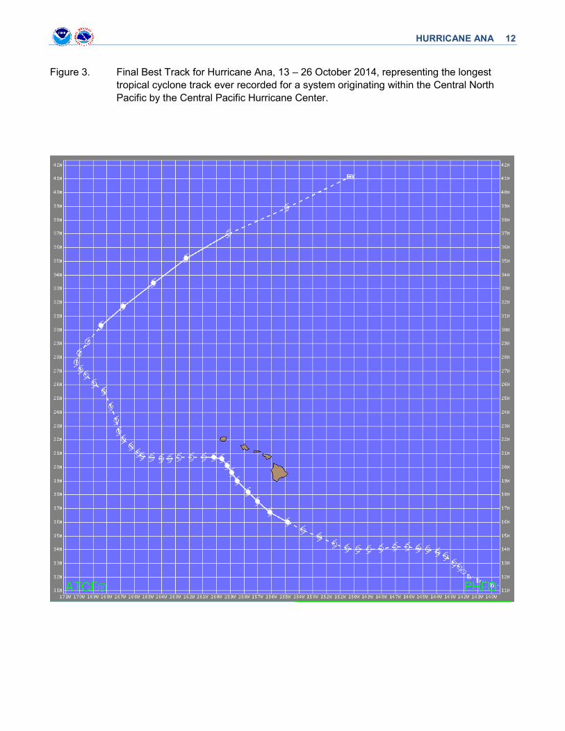
The best track for Ana is listed in Table 1 and illustrated in Figure 3. Observations of Ana included
subjective satellite-based Dvorak technique intensity estimates from the Tropical Analysis and Forecast
Branch (TAFB), the Satellite Analysis Branch (SAB), the CPHC, and the Joint Typhoon Warning Center
(JTWC), and objective Advanced Dvorak Technique (ADT) estimates from the Cooperative Institute for
Meteorological Satellite Studies/University of Wisconsin-Madison. Data and imagery from NOAA polar-
orbiting satellites including the Advanced Microwave Sounding Unit (AMSU), the NASA Tropical Rainfall
Measuring Mission (TRMM), the European Space Agency’s Advanced Scatterometer (ASCAT), and
Defense Meteorological Satellite Program (DMSP) satellites, among others, were also useful in
constructing the best track of Ana.
The Kauai (PHLI) WSR-88D Doppler radar was used to provide a positional fix for Ana at 0600
UTC 19 October. Also, the Molokai (PHMO) WSR-88D Doppler radar derived storm total rainfall for the
period 17-20 October can be seen in Figure 5. Air Force Reserve aircraft kindly provided reconnaissance
data during the period of closest approach to the main Hawaiian Islands, 18 – 20 October.
We have two Local Storm Reports (LSRs) within the Honolulu Weather Forecast Office (WFO)
archive associated with Hurricane Ana, both referencing rainfall effects. The first, issued at 1730 UTC
18 October, described the closure of the main highway through Kawa Flats, on the Big Island, due to
high water. The second, issued at 2340 UTC 19 October, described the closure of Kona Street near Ala
Moana Mall in Honolulu due to “knee high water.”
WFO Honolulu issued a Public Information Statement at 0645 UTC 20 October listing total
accumulated rainfall for Ana as of that time. Ana was west of 161W by this time, so these rainfall amounts
could be considered storm totals. While all the totals are listed in Table 4, some notable ones are those
in excess of 11 inches found on Oahu and the Big Island. Just over six inches fell over Mount Waialeale
on Kauai, while over three inches fell across portions of Maui County. Figure 5, mentioned above, shows

HURRICANE ANA 4
how close the swath of much heavier rainfall was to the islands. A track change of just 20 miles may
have doubled recorded rainfall.
Hurricane Ana passed just far enough south of the main Hawaiian Islands to keep the 34 knot
wind radius offshore, except anecdotally across southern portions of Niihau as mentioned in the next
section. There were no tropical storm force winds officially recorded across the state.
CASUALTY AND DAMAGE STATISTICS There were no real-time reports of wind damage across the main Hawaiian Islands as a result of
Hurricane Ana. However, an anecdotal wind damage report was phoned in to the Lihue Data Collection
Office (DCO) about a month after the event. According to that station’s shift log entry of 2031 UTC 18
November, Keith Robinson (Half-owner of Niihau Island and Robinson Enterprises) called in to discuss
a post Tropical Storm damage assessment for the southern portion of Niihau. He was able to tour the
southernmost area of that island (South-Point and windward areas along the coast and up to about a half
mile inland) and reported extensive vegetation damage and tree top levelling “with an estimated Beaufort
Wind Scale range of 40-50 mph.” The log entry also states that Mr. Robinson visited the same area about
a week before Ana passed and that none of the damage was evident at that time. While this report lacks
the veracity of an official observation by a government observer, trained weather spotter or first-
responder, it is consistent with the wind conditions expected within the tropical storm warning in effect for
Kauai County.
There were no recorded casualties associated with Hurricane Ana.
FORECAST AND WARNING CRITIQUE
A verification of CPHC official track forecasts for Ana is given in Table 2. With 54 best track points
spanning almost two weeks, Hurricane Ana entered the record books for continuous track length in the
Central North Pacific basin. This record length likely contributed to the finding that CPHC forecast errors
for this system were smaller than the floating five-year average at all tau, allowing forecasters to more
easily determine which guidance was most helpful and then adjust accordingly. Ana had a long recurving
track essentially across open water, unlike the earlier Iselle which deteriorated significantly after
impacting the Big Island. Future researchers may explore the significance of the westward track turn and
slowing of Ana after passing the Big Island, possibly attributing this change to local island effects.
However, an inspection of the best track in Figure 3 shows that Ana made two similar westward jogs,
including just before final recurvature far west of the islands. In general, CPHC track forecasts were
better than GFDL and the Beta and Advection models. European and consensus models had less track
error. Interestingly, only EGRI outperformed CPHC at tau 120, while only consensus and GFS
outperformed CPHC at tau 12.
Several CPHC hurricane specialists anecdotally mentioned during this writing that consensus
track guidance was too far to the left during Ana’s approach to the main Hawaiian Islands as a hurricane.
As a result, this group asserted that their forecast tracks were more accurate than consensus track
guidance during this critical period in spite of less error with consensus track guidance overall. To test

HURRICANE ANA 5
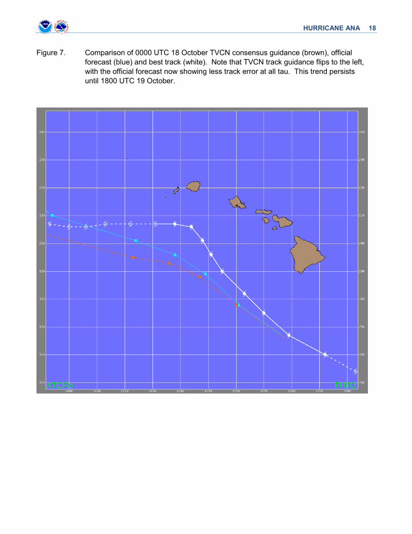
this, a visual comparison of the consistently used consensus model, TVCN, with the official track
forecasts and the best track within ATCF from 0000 UTC 17 October through 0000 UTC 20 October was
performed. From 0000 UTC through 1200 UTC 17 October (Figure 6), the official track and consensus
guidance closely coincided, with both closely following the actual best track through its gradual curve
increasingly to the north through that time. However, possibly sensing a future Ana turn to the west,
consensus track guidance very noticeably flipped to the left of the official track forecast and the actual
best track at 0000 UTC 18 October (Figure 7). Consensus track guidance through tau 48 then remained
consistently to the left of the official track through 0000 UTC 20 October (except for one forecast cycle at
1800 UTC 18 October). Ana made its pronounced turn almost due west at 1800 UTC 19 October as it
was moving west of the main Hawaiian Islands. Based on this visual comparison, it seems that in the
period between the consensus track guidance flip to the left and Ana’s actual turn to the west (when Ana
was closest to the islands, from 0000 UTC 18 October through 1200 UTC 19 October) the assertion of
the CPHC forecasters is correct. However, since consensus track guidance accuracy was eventually
aided by Ana’s actual turn to the west after 1800 UTC 19 October (Figure 8), the short-term CPHC
advantage in track accuracy over consensus track guidance was cancelled out in the longer run.
A verification of CPHC official intensity forecasts for Ana is given in Table 3. In short, CPHC
outperformed all intensity guidance at all tau. CPHC also improved its own overall intensity statistics by
besting its floating five-year average intensity errors at all tau. For Ana, intensity guidance was biased
high, likely in response to the abundance of warm water around and especially north through northwest
of the main Hawaiian Islands.
As Ana approached the main Hawaiian Islands, it was well-behaved, developing and moving in a
manner consistent with conceptual models. This allowed CPHC forecasters to issue timely watches and
warnings as the threat to the islands unfolded. In the end, Ana essentially missed the islands, with tropical
storm force winds and the heaviest rainfall remaining offshore. However, its proximity and track roughly
parallel to the island chain necessitated a rigorous series of tropical storm watches and warnings,
mirrored by associated local watches and warnings from the Honolulu WFO. The Wind Speed
Probabilities (PWS) product proved quite valuable here, with onset times for 10% probabilities of 34 knot
wind speeds used to determine whether and when to issue tropical storm watches and warnings in given
locations. Local flood warnings verified as heavy rainfall closed roads on Oahu and the Big Island. Once
again, Figure 5 shows how close the swath of devastatingly heavy rainfall was.
This system was well-anticipated, with the Tropical Weather Outlook (TWO) of 0000 UTC 12
October initially assigning a 48-hour development probability of 20%. Subsequent increases in 48-hour
development probability to 50%, 60%, and 80% in TWO’s issued 12, 30 and 36 hours later, respectively,
show that CPHC was not taken by surprise by this system, in spite of its rather late-season initialization
and development.

HURRICANE ANA 6
Table 1. Best track for Hurricane Ana, 13 – 26 October 2014.
Date/Time (UTC)
Latitude (°N)
Longitude (°W)
Pressure (mb)
Wind Speed (kt)
Stage
13 / 0600 11.8 140.9 1008 25 low
13 / 1200 12.1 141.6 1008 25 "
13 / 1800 12.4 142.0 1007 30 tropical depression
14 / 0000 12.7 142.3 1005 35 tropical storm
14 / 0600 13.0 142.7 1003 40 "
14 / 1200 13.5 143.3 1000 45 "
14 / 1800 13.8 143.9 996 55 “
15 / 0000 14.0 144.6 996 55 “
15 / 0600 14.1 145.3 994 60 “
15 / 1200 14.2 146.1 994 60 “
15 / 1800 14.3 147.0 994 60 “
16 / 0000 14.1 148.0 998 55 “
16 / 0600 14.0 148.9 1000 50 “
16 / 1200 14.0 149.7 1000 50 “
16 / 1800 14.1 150.5 1000 50 “
17 / 0000 14.4 151.4 1000 50 “
17 / 0600 14.9 152.5 998 55 “
17 / 1200 15.4 153.7 992 60 “
17 / 1800 16.0 154.8 990 65 hurricane
18 / 0000 16.6 156.2 989 70 hurricane
18 / 0600 17.5 157.0 985 75 hurricane
18 / 1200 18.2 157.7 986 70 hurricane
18 / 1800 19.0 158.5 988 70 hurricane
19 / 0000 19.6 158.9 989 70 hurricane
19 / 0600 20.1 159.2 989 70 hurricane
19 / 1200 20.6 159.6 989 70 hurricane

HURRICANE ANA 7
Date/Time (UTC)
Latitude (°N)
Longitude (°W)
Pressure (mb)
Wind Speed (kt)
Stage
19 / 1800 20.7 160.2 992 65 hurricane
20 / 0000 20.7 160.9 994 60 tropical storm
20 / 0600 20.7 161.8 995 60 “
20 / 1200 20.7 162.7 995 60 “
20 / 1800 20.6 163.4 996 55 “
21 / 0000 20.5 164.0 998 50 “
21 / 0600 20.7 164.7 999 45 “
21 / 1200 20.8 165.4 1002 40 “
21 / 1800 20.9 165.7 1005 35 “
22 / 0000 21.6 166.1 1005 35 “
22 / 0600 22.0 166.8 1005 35 “
22 / 1200 22.6 167.1 1005 35 “
22 / 1800 23.4 167.3 1005 35 “
23 / 0000 24.4 167.7 1005 35 “
23 / 0600 25.5 168.2 1002 40 “
23 / 1200 26.1 168.9 998 45 “
23 / 1800 26.7 169.5 999 45 “
24 / 0000 27.1 169.9 1000 45 “
24 / 0600 27.6 170.2 1000 45 “
24 / 1200 28.2 169.9 999 50 “
24 / 1800 29.1 169.4 996 55 “
25 / 0000 30.2 168.5 988 65 hurricane
25 / 0600 31.7 166.8 987 65 hurricane
25 / 1200 33.4 164.6 987 65 hurricane
25 / 1800 35.2 162.2 987 65 hurricane
26 / 0000 37.0 159.1 988 60 tropical storm
26 / 0600 38.9 154.9 989 55 “
26 / 1200 41.2 150.2 992 50 extratropical

HURRICANE ANA 8
Date/Time (UTC)
Latitude (°N)
Longitude (°W)
Pressure (mb)
Wind Speed (kt)
Stage
18 / 0600 17.5 157.0 985 75 maximum wind and minimum pressure
Table 2. Homogeneous comparison of selected track forecast guidance models (in n mi) for
Hurricane Ana, 13 – 26 October 2014. Errors smaller than the CPHC official forecast are
shown in boldface type.
Model ID Forecast Period (h)
12 24 36 48 72 96 120
OFCL 27.7 49.2 62.8 74.1 126.7 143.8 155.8
OCD5 46.4 100.8 155.9 190.1 203.3 201.1 171.3
GFSI 27.3 39.2 48.2 60.8 96.7 127.3 197.4
GHMI 28.2 50.5 69.9 89.5 149.6 235.7 365.7
HWFI 28.6 46.7 58.7 73.0 119.6 148.9 190.1
EGRI 29.0 46.2 60.9 77.2 98.7 112.2 151.1
EMXI 34.7 45.4 91.5 - - - -
CMCI 37.6 63.0 101.9 - - - -
TCON 24.4 38.4 50.4 60.9 95.0 118.0 168.2
TVCA/TVCE 24.8 40.1 52.7 64.9 92.4 114.7 164.5
AEMI 27.9 46.5 61.0 71.6 109.1 144.9 188.3
BAMS 46.1 86.6 120.6 153.1 212.6 242.5 252.7
BAMM 31.7 53.5 69.9 79.6 98.8 113.3 182.1
BAMD 34.4 55.9 75.2 88.1 122.1 185.2 306.8
Forecasts 48 46 44 42 38 34 31

HURRICANE ANA 9
Table 3. Homogeneous comparison of selected intensity forecast guidance models (in kt) for
Hurricane Ana, 13 – 26 October 2014. Errors smaller than the CPHC official forecast are
shown in boldface type.
Model ID Forecast Period (h)
12 24 36 48 72 96 120
OFCL 5.0 7.8 10.7 12.9 15.3 13.2 11.6
OCD5 8.9 14.0 19.2 17.5 25.7 23.6 14.8
HWFI 6.1 9.4 11.4 14.9 19.0 20.7 18.5
GHMI 5.6 9.9 15.6 19.1 28.4 31.9 36.5
DSHP 5.4 9.5 13.2 15.8 18.1 19.6 14.0
LGEM 5.5 9.5 13.0 15.3 18.2 20.3 15.2
ICON 5.1 8.1 11.3 14.2 18.1 19.8 18.1
IVCN 5.1 8.1 11.3 14.2 18.1 19.8 18.1
Forecasts 48 46 44 42 38 34 31

HURRICANE ANA 10
Figure 1. National Weather Service Environmental Modeling Center Sea Surface Temperature
Analysis for 24 October 2014.

HURRICANE ANA 11
Figure 2. National Weather Service Environmental Modeling Center Sea Surface Temperature
Anomalies for 24 October 2014.
HURRICANE ANA 12
Figure 3. Final Best Track for Hurricane Ana, 13 – 26 October 2014, representing the longest
tropical cyclone track ever recorded for a system originating within the Central North
Pacific by the Central Pacific Hurricane Center.

HURRICANE ANA 13
Figure 4. GOES-15 enhanced infrared image of Ana at 0600 UTC, 25 October 2014, as it
rebuilds to hurricane strength after recurvature within anomalously warm water
northwest of the main Hawaiian Islands.

HURRICANE ANA 14
Figure 5. Storm total rainfall accumulation derived from Molokai (PHMO) WSR-88D Doppler
radar from 2015 UTC October 17 through 1339 UTC October 20. Of note is the 15+
total rainfall area as close as 20 miles southwest of Oahu during this period.

HURRICANE ANA 15
Table 4. Storm total rainfall accumulations as of 0645 UTC 20 October.

HURRICANE ANA 16

HURRICANE ANA 17
Figure 6. Comparison of 1200 UTC 17 October TVCN consensus guidance (brown), official
forecast (blue) and best track (white). Note close agreement between TVCN and
official forecast tracks, especially through 24 hours. TVCN and official track errors
then appear to cancel each other out from 36 through 72 hours.
HURRICANE ANA 18
Figure 7. Comparison of 0000 UTC 18 October TVCN consensus guidance (brown), official
forecast (blue) and best track (white). Note that TVCN track guidance flips to the left,
with the official forecast now showing less track error at all tau. This trend persists
until 1800 UTC 19 October.

HURRICANE ANA 19
Figure 8. Comparison of 1800 UTC 19 October TVCN consensus guidance (brown), official
forecast (blue) and best track (white). Ana has now turned west, and TVCN track
guidance now has less track error.