hunt planner quick start guide - wa
TRANSCRIPT

Hunt Planner Quick Start GuideWDFW Wildlife Program, 2021

Welcome to the new
Hunt Planner!
This document is broken up
into a few main sections to
address each component of the
webapp:
• Map Tools
• Reviewing Regulations
• Reviewing Other Data
• Highlighting Units and
Filtering Results
Hunt Planner Quick Start Guide
© WDFW Wildlife Program, 2020

Map Tools
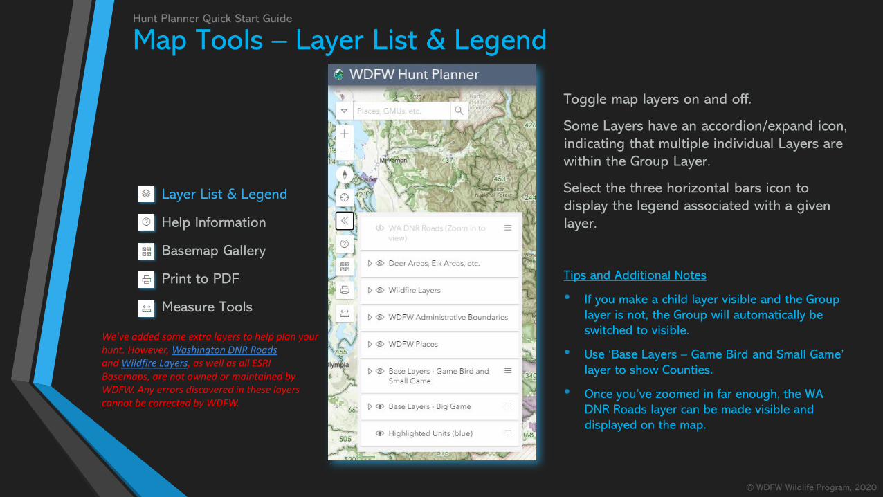
Layer List & Legend
Help Information
Basemap Gallery
Print to PDF
Measure Tools
Hunt Planner Quick Start Guide
© WDFW Wildlife Program, 2020
All the map tools are in
the top left-hand corner
of the webapp. Clicking
on an icon will expand
the associated tool.
Layer List & Legend
Help Information
Basemap Gallery
Print to PDF
Measure Tools
Hunt Planner Quick Start Guide
© WDFW Wildlife Program, 2020
Toggle map layers on and off.
Some Layers have an accordion/expand icon,
indicating that multiple individual Layers are
within the Group Layer.
Select the three horizontal bars icon to
display the legend associated with a given
layer.
Tips and Additional Notes
• If you make a child layer visible and the Group
layer is not, the Group will automatically be
switched to visible.
• Use ‘Base Layers – Game Bird and Small Game’
layer to show Counties.
• Once you’ve zoomed in far enough, the WA
DNR Roads layer can be made visible and
displayed on the map.
Map Tools – Layer List & Legend
We've added some extra layers to help plan your hunt. However, Washington DNR Roadsand Wildfire Layers, as well as all ESRI Basemaps, are not owned or maintained by WDFW. Any errors discovered in these layers cannot be corrected by WDFW.

Map Tools – Help Information
Layer List & Legend
Help Information
Basemap Gallery
Print to PDF
Measure Tools
Hunt Planner Quick Start Guide
© WDFW Wildlife Program, 2020
The Help Information widget has all the
same content as was displayed on the
landing page (i.e. the screen where you
clicked ‘I Agree’).
There are links to provide feedback or
report an issue using Survey123.
Expand the accordions for additional
resources: links to other relevant web
pages, information about application
versions, and important legal references.
Tips and Additional Notes
• Expand the ‘Welcome Note and Tips’ to
review the ‘sticky note’ displayed when the
webmap loads.
• Check the ‘Application Release Notes’ for
information on when new regulations will be
available (e.g., Game Bird in August).

Map Tools – Basemap Gallery
Layer List & Legend
Help Information
Basemap Gallery
Print to PDF
Measure Tools
Hunt Planner Quick Start Guide
© WDFW Wildlife Program, 2020
Select from a variety of basemap options,
including satellite imagery.
Tips and Additional Notes
• The GMU boundaries and other Base Layers are not
part of the Basemap. Change visibility of the Base
Layers using the Layer List & Legend tool.
• The default Basemap – ESRI Topo – displays similar
land ownership data. We cannot make changes to any
potential errors in this, or any available Basemap.

Map Tools
Layer List & Legend
Help Information
Basemap Gallery
Print to PDF
Measure Tools
Hunt Planner Quick Start Guide
© WDFW Wildlife Program, 2020
Print a geo-enabled PDF of the current
map extent.
Select page size and other options.
Tips and Additional Notes
• While the tool only provides basic
functionality, look for an improved version in
a later release.

Map Tools – Measure Tool
Layer List & Legend
Help Information
Basemap Gallery
Print to PDF
Measure Tools
Hunt Planner Quick Start Guide
© WDFW Wildlife Program, 2020
Measure distance and
area.
Open the tool to
display measurement
options: Distance, Area,
Clear Measurement.

Map Tools – Search ToolHunt Planner Quick Start Guide
© WDFW Wildlife Program, 2020
The Search Tool has been
greatly improved to only query
locations in Washington State,
and can now search layers
used in the webmap.
Addresses, Place Names, Coordinates
WDFW Places (e.g., Water Access Sites)
GMUs, Deer Areas, etc.
E.g., Glacier Peak, WA
E.g., 101 for GMU 101
E.g., Badger Lake Water Access Site

Review RegulationsHunt Planner Quick Start Guide
© WDFW Wildlife Program, 2020
The Review Regulations Tool provides
two ways to find opportunities of
interest.
Review All Opportunities
Simply click the map and all regulations
will be returned (Big Game, Small Game,
and Game Bird)
Highlight Units and Filter Results
Provide criteria to find certain
opportunities, and if desired use those
criteria to filter regulation results

Review Regulations – All OpportunitiesHunt Planner Quick Start Guide
© WDFW Wildlife Program, 2020
1. Click the map on an area of interest.
2. All hunting opportunities at that location* are returned,
including a link to the associated WDFW Regional Office
3. Review hunting regulations related to the Hunt Unit(s)
that intersect the click-location by expanding any of the
Animal Opportunity accordions.
Popup Content
• If the click-location intersects a WDFW Wildlife Area, a popup will
be displayed with a link to find out more information
• Similarly, if you have PLHO or Water Access Sites visible and the
click-location intersects them, a popup will be displayed with a
link to find out more information
ReminderIf a hunt has multiple date ranges, it will be displayed multiple times for each unique date range

Review Regulations – Highlight Units and Filter ResultsHunt Planner Quick Start Guide
© WDFW Wildlife Program, 2020
1. Select an animal
2. If there are multiple Opportunities, Methods, or types of Legal Harvest for that
animal, you can select additional criteria. If there are not multiple options (e.g.,
Bighorn Sheep are Special Permit only) then the drop down menu will be
disabled.
3. Click ‘Highlight units on the map’ to see where your hunting opportunity of
interest is available (blue cross-hatched symbol)
Filter Regulations
• If you’d like the regulation results to honor the parameters
you’ve entered, click to ‘Filter regulations base on this criteria?’
toggle.
• You must click the map again after toggling the switch to apply
the filter.

Reviewing Results: RegulationsHunt Planner Quick Start Guide
© WDFW Wildlife Program, 2020
Expand an Animal Opportunity accordion to review
regulations. In this example, Deer General Season has 5
opportunities in GMU 251.
Click on the regulation ‘card’ to highlight the unit
boundary on the map. Use the toggle to turn the layer on
and off

Reviewing Results: RegulationsHunt Planner Quick Start Guide
© WDFW Wildlife Program, 2020
Important Restrictions are displayed in red. Some
opportunities are limited to senior hunters only. Similarly,
some hunts have exceptions to the Hunt Unit – if you click
on a regulation with a unit exception, it will be shown in
red hatched on the map

Reviewing Results: WDFW PlacesHunt Planner Quick Start Guide
© WDFW Wildlife Program, 2020
For every Hunt Unit in each Animal Opportunity accordion,
there is a ‘Review WDFW Places in <unit>’ button (except
where not informative, such as for statewide hunts). Click
the button to search for WDFW Wildlife Areas, Pheasant
Release Sites, Water Access
Sites, and Private Lands
Hunting Opportunities in
that unit.
Expand the accordion to
review information about
those Places (e.g., Water
Access Sites with links to
more information on the
WDFW website).

Reviewing Results: HarvestHunt Planner Quick Start Guide
© WDFW Wildlife Program, 2020
For certain animal opportunities*, two additional buttons
are available to review the previous year’s harvest results
or plot the total harvest over time for that specific animal-
opportunity-unit. Expand accordions for Harvest, Antlered
Harvest by Point, etc.
The harvest graph
displays total harvest
over time. Hover your
mouse over the graph to
get exact values for each
year.
*GMU-level harvest results are only available for Deer General, Deer Permit, Elk General, Elk Permit, Black Bear General,Black Bear Permit. (Cougar 2020 results available in Summer, 2021).