howth fhc harbour dredging and reclamation project
TRANSCRIPT

Howth FHC Harbour Dredging and Reclamation Project
Marine Engineering Division (DAFM) &
Malachy Walsh and Partners
2021
Public Consultation Information – Proposed Planning Application at Howth Fishery Harbour Centre

Presentation Structure
Introduction
Site Background and Historical Works
Description of Proposed Development
Post Construction Operations
Preparation of Planning Application
Next Steps…

1 Introduction

An Roinn Talmhaíochta, Bia agus Mara │ Department of Agriculture, Food and the Marine
Purpose of Presentation
• This presentation provides an overview of the proposed development at Howth Harbour, Co. Dublin.
• It outlines the Environmental Impact Assessment Report (EIAR) and Natura Impact Statement (NIS) that are being prepared in support of the application.
• This application relates to the proposed dredging of Howth Harbour required to allow for the safe use of the harbour by vessels, and beneficial reuse of the dredge material in land reclamation.

An Roinn Talmhaíochta, Bia agus Mara │ Department of Agriculture, Food and the Marine
Public Consultation Approach & Covid-19
• It had been intended to hold public meetings to discuss the information provided in this presentation, but this is now not
possible, due to the restrictions applied by the Covid-19 measures on public gatherings.
• This presentation is being made available online to inform people of the planning application currently being prepared. It is
intended to submit the planning application to Fingal County Council in May 2021.
• You may email any comments you have on the proposed application to the design team at
[email protected]. Comments received will be addressed as appropriate in the EIAR and NIS which will be
submitted with the application.
• You will have the opportunity to make a formal observation to Fingal County Council when the application has been lodged.
• The Government has announced emergency planning measures, which will protect the rights of people to comment on
planning applications submitted during the timeline of Covid-19 restrictions. Details on these measures can be found here –
https://www.housing.gov.ie/.

2 Site Background and Historical Works

An Roinn Talmhaíochta, Bia agus Mara │ Department of Agriculture, Food and the Marine
Historical Works and Project Need
• The harbour was upgraded in the 1980s in order to improve navigation conditions at the harbour mouth, reduce wave conditions within the harbour, provide additional facilities and increased water depths.
• The harbour was dredged and the reclaimed material used to upgrade the harbour layout.
• Works included the building of concrete quay walls, the construction of a Syncrolift shiplift and the creation of the middle pier, marina area and inner breakwater.
• Since the upgrade, a build up of silt has resulted in a rise in seabed levels. This siltation , combined with increasing vessel sizes results in insufficient water depth at certain tide states, over much of the harbour.
• The Public slipway and RNLI slipway & berth have seen considerable siltation, particularly at low tide, resulting in difficulty for the rescue vessels to mobilize.

An Roinn Talmhaíochta, Bia agus Mara │ Department of Agriculture, Food and the Marine
Background to Application
• The fishing and marine commercial industry use Howth FHC extensively as a landing harbour.
• It also has an important role as a service harbour with vessels availing of the departmental boat lift and yard for servicing.
• Howth Harbour provides easy and close access to the markets, processing, servicing, technical and logistical benefits that the
Greater Dublin Area brings.
• Howth Fishery Harbour Centre requires dredging in order to facilitate safe vessel access to the harbour during any tide state.

3 Description of Proposed Development

Body Level One
Body Level Two
Body Level Three
Body Level Four
Body Level Five
10 An Roinn Talmhaíochta, Bia agus Mara | Department of Agriculture, Food and the Marine
Project Aims • To dredge the harbour, in order to restore adequate water depth for vessels using the harbour.
• To provide for access on the widest possible range of tides.
• To facilitate the use of the harbour by future vessels. Over the last 30 years, the fishing industry has seen the use of deeper and wider vessels.
• Provide for a mix of recreational public access green areas, slipway access to the water for small craft and provide areas for business, harbour operations and transport in line with the current designation of the West Pier.

Body Level One
Body Level Two
Body Level Three
Body Level Four
Body Level Five
11 An Roinn Talmhaíochta, Bia agus Mara | Department of Agriculture, Food and the Marine
The proposed development will involve the following main elements: • Dredging of the harbour and reclamation of land on the West side of the West Pier using treated dredge
material;
• The dredge material will be treated using soil stabilisation techniques prior to placement in the reclamation area. This will improve the strength of soil, bind in contaminants and minimise the potential for leachate;
• Coastal protection works to the perimeter of the reclaimed area;
• Landscaping on the reclaimed area and construction of footways, roadways and parking areas;
• Construction of slipway for access to the water;
• Construction of storage areas for harbour activities;
• Provision of necessary services.

An Roinn Talmhaíochta, Bia agus Mara │ Department of Agriculture, Food and the Marine
This image indicates the zones to be dredged within the harbour, and the proportional infill footprint that would be created, to the West of the West Pier A more detailed site location and layout plan is provided in the following slides.
Extent of Proposed Dredging and Reclamation

An Roinn Talmhaíochta, Bia agus Mara │ Department of Agriculture, Food and the Marine
Proposed Site Layout and Land Use

An Roinn Talmhaíochta, Bia agus Mara │ Department of Agriculture, Food and the Marine
Proposed Development: aerial view from south west
An Roinn Talmhaíochta, Bia agus Mara │ Department of Agriculture, Food and the Marine
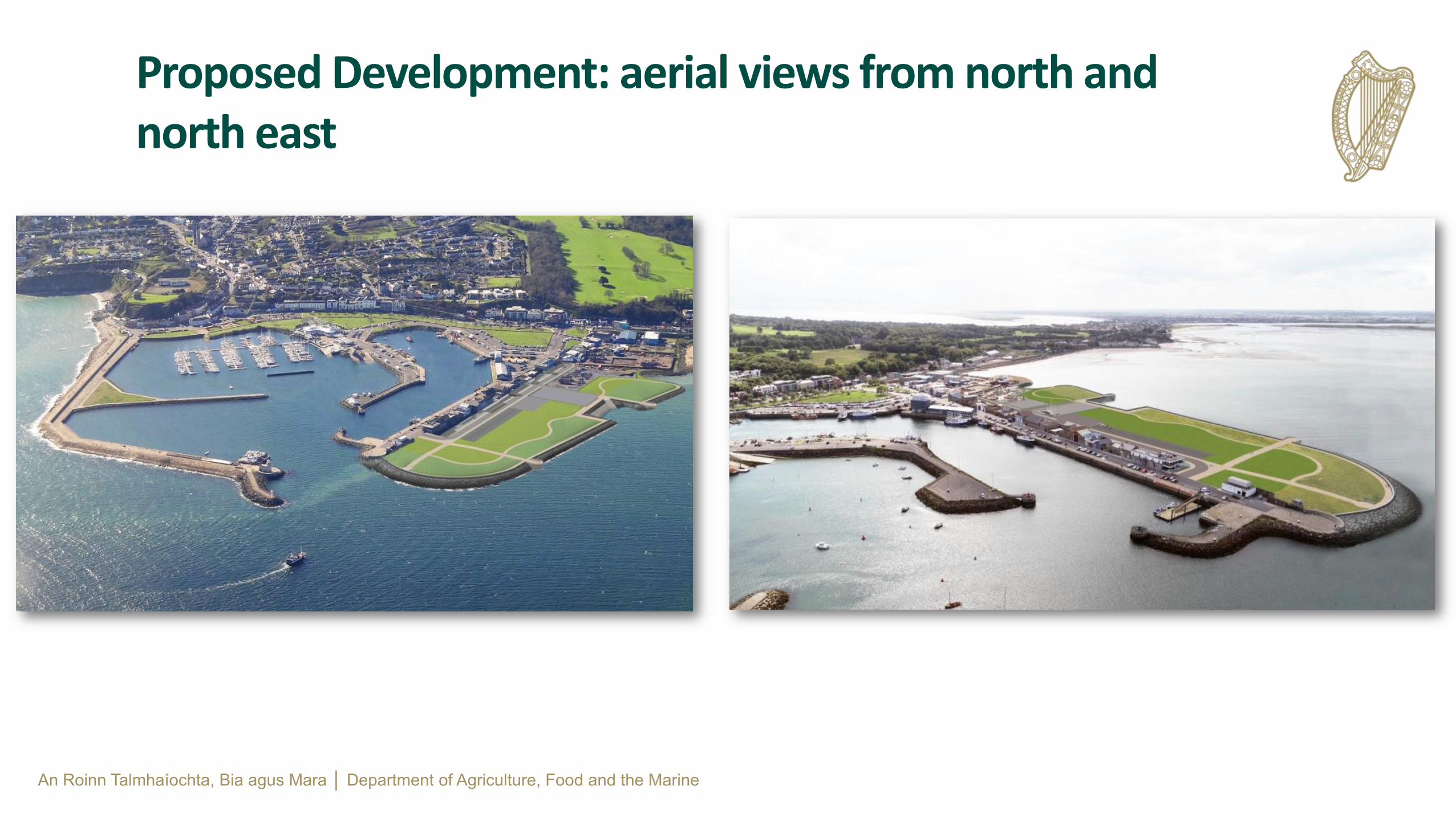
Proposed Development: aerial views from north and north east

An Roinn Talmhaíochta, Bia agus Mara │ Department of Agriculture, Food and the Marine
Proposed Development: aerial view showing water access area

4 Sustainability and
Circular Economy

An Roinn Talmhaíochta, Bia agus Mara │ Department of Agriculture, Food and the Marine
The project will be designed and constructed with a strong emphasis on sustainability and circularity through the beneficial reuse of dredged material to deliver an enhanced harbour facility. The benefits are as follows:
• Delivery in line with the aims and objectives of a Circular Economy as recommended under EU and national
legislation
• Contributes to a reduced carbon footprint for Ireland
• Delivers a sustainable project solution
• Recognises and promotes environmental and economic benefits
Sustainability and Circular Economy
Pushing sustainability and environmental focus further, the project will also aim to achieve CEEQUAL certification. CEEQUAL provides a framework for projects to integrate environmental, social and sustainability benefits which go above and beyond the usual planning requirements.

4 Post Construction

An Roinn Talmhaíochta, Bia agus Mara │ Department of Agriculture, Food and the Marine
• Dredging of the harbour and reclamation of land on the West side of the West Pier presents a unique opportunity for expanding
upon the recreational and educational potential of the area and other nearby natural environments of high quality.
• The reclamation will enhance the operations of the harbour while retaining its existing maritime industrial character.
• The creation of the new land will contribute to the diversity of the area as a major venue for leisure activities for a wide range of recreational users of the harbour and reinforce the pier as an important tourist destination.
Enhancement of Current Harbour Operations

An Roinn Talmhaíochta, Bia agus Mara │ Department of Agriculture, Food and the Marine
• Protection works to the perimeter of the reclaimed area will allow a substantial coastal linear park with a variety of publicly accessible
amenity areas for passive recreation, expansive views and slipway access to the water for small craft.
• The incorporation of storage areas for fishing nets, equipment and machinery, combined with adequate provision for public footways, roadways, bus stops and car parking areas, will provide a vibrant safe and accessible maritime environment for people of all ages.
• The reclamation proposals build upon the social, architectural and maritime heritage significance of the harbour while offering increased opportunities for greatly enhancing the public’s awareness of the environmental quality of the area and for experiencing the panoramic views from Portrane to Portmarnock to Baldoyle and Ireland’s Eye.
Enhancement of Current Harbour Operations (contd.)

5 Preparation of
Planning Application

An Roinn Talmhaíochta, Bia agus Mara │ Department of Agriculture, Food and the Marine
• A planning application is currently being prepared by the Department of Agriculture, Food and the Marine. It is intended that this application will be submitted to Fingal County Council (FCC) in May 2021.
• Consultation with statutory bodies, such as FCC, the EPA, Marine Institute, the National Monuments Service and the National Parks and Wildlife Service (NPWS) has been undertaken as part of the EIA and Appropriate Assessment process.
• The application will include the following documentation: Planning Statement Screening for Appropriate Assessment and Natura Impact Statement Flood Risk Assessment Environmental Impact Assessment Report (Volumes 1-3) Infrastructure and Architectural Drawings
• Public observations to the planning application can be made to Fingal County Council when the application is lodged. Note that in line
with emergency planning measures, due to Covid-19, the timeline for public consultation will be extended. For further information on these measures see https://www.housing.gov.ie/.
Planning Application Process

An Roinn Talmhaíochta, Bia agus Mara │ Department of Agriculture, Food and the Marine
• An Environmental Impact Assessment Report (EIAR) is being prepared to accompany the planning application.
• The EIAR will be available for review along with all other planning documentation when the application is submitted.
• Comments to the design team on issues to be considered in the EIAR should be forwarded to: [email protected] by 9th April 2021.
Environmental Impact Assessment Report (EIAR)
EIAR Study and Assessment Areas Specific topics
Potential Impacts on Population and Human Health
Noise and Vibration
Traffic
Air Quality and Climate
Water Quality
Potential Impacts on Landscape and Visual Resources Changes in character and views
Visual Impacts
Potential Impacts on Hydrology and Hydrogeology
Water Quality
Surface water run-off and Control
Flood Risk Assessment
Potential Impacts on Material Assets
Utilities
Archaeology and Cultural Heritage
Waste Management
Potential Impacts on Biodiversity and Natura 2000 Sites
Aquatic Ecology
Terrestrial Ecology
Appropriate Assessment
Bird populations
Potential Impacts on Roads and Infrastructure
Traffic and Transport
Traffic Management
Visual Impacts • An Industrial Emissions / Waste license
will also need to be acquired from the EPA.
Industrial Emissions License

An Roinn Talmhaíochta, Bia agus Mara │ Department of Agriculture, Food and the Marine
• An Appropriate Assessment (AA) is an evaluation of the potential impacts of a plan or project on the conservation objectives of a Natura 2000 site.
• The site is situated near several Special Protection Areas (SPA) and Special Areas of Conservation (SAC), the closest of which are Howth Head SAC, Baldoyle Bay SAC, Ireland’s Eye SPA and Howth Head Coast SPA. There are a total of eighteen designated Natura 2000 within 15km of the proposed works.
• A Stage 2 Natura Impact Statement (NIS) is being prepared to support the planning
application.
• Consultation with the NPWS and FCC has been undertaken as part of this assessment.
• The competent authority, in this case, Fingal County Council carries out the AA, based on the NIS and any other information it may consider necessary.
Appropriate Assessment (AA)

An Roinn Talmhaíochta, Bia agus Mara │ Department of Agriculture, Food and the Marine
Special Protection Areas and Special Areas of Conservation

An Roinn Talmhaíochta, Bia agus Mara │ Department of Agriculture, Food and the Marine
Surveys and Studies
• Ground investigation
• Contamination analysis
• Treatment trials
• Bird surveys
• Habitat mapping (marine and terrestrial)
• Archaeological survey
• Oceanographic survey
• Coastal process modelling
• Architectural heritage
• Risk assessment
• Other
Assessment Summary
• Ecological designated sites
• Biodiversity including marine ecology
• Contamination - assessment of sediments
• Archaeological and architectural heritage
• Landscape and visual
• Coastal process modelling
• Flood risk assessment
• Traffic
• Marine Mammals
• Soils and Geology
• Marine Mammals
Key Factors to be Assessed

6 Next Steps…

An Roinn Talmhaíochta, Bia agus Mara │ Department of Agriculture, Food and the Marine
Next steps…
It is intended to submit the planning application to Fingal
County Council in May 2021.
Formal observations on
the planning application may be lodged with Fingal
County Council when the
application is lodged.
Fingal County Council will assess the
planning application and any formal
observation received before issuing a
decision.
Comments on the proposed planning application can be directed to the design team
at: howthengineering@agricultu
re.gov.ie by 9th April 2021
Comments received at this stage in the
process will be addressed as
appropriate in the EIAR and NIS.
The planning documentation,
EIAR and NIS will be finalised in May
2021.
Data Protection The Department of Agriculture, Food and the Marine (DAFM) are collecting the data. The data processing is lawful under GDPR Article 6 1 (e) processing and is necessary for the performance of a task carried out in the public interest or in the exercise of official authority vested in the controller. The data will be used to inform the Environmental Impact Assessment Report (EIAR), the Natura Impact Assessment (NIS) and overall design. The email submissions will only be seen by DAFM and their Engineering and Environmental Consultants, Malachy Walsh and Partners. The data will be held for a period of six years.

An Roinn Talmhaíochta, Bia agus Mara │ Department of Agriculture, Food and the Marine
Thank you for taking the time to review this presentation.
Please email any comments to the Design Team on [email protected] by the 9th April 2021.