how wetlands influence development
TRANSCRIPT

Pacesetters – Building Strong!
How Wetlands Influence Development
Pacesetters – Building Strong!
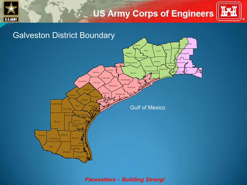
Wh ar tonBrazo ria
For t B end
Harr is
Waller
Aus tin
Gon zales
Fayette
Colorado
Lav aca
Jackso n Matago rda
Calho un
Montg omery
Walker
San Jac in to
LibertyJef fe rson
Chambers
Hard in
TylerPolk
Trin ity
Galveston
Oran ge
Jasp erNewto n
Vern on
Beaureg ard
Calcasieu
Camero n
Karnes
DeW itt
Vic toria
Goliad
RefugioBee
Live O ak
McMullen
Duv al
Jim W ells
Nueces
San Patric io
Kleberg
Zapata
Jim H og g
Broo ks
Kenedy
Willacy
Camero n
Hidalgo
Starr
Aran sas
Kenedy
Galveston District Boundary
Gulf of Mexico

Pacesetters – Building Strong!
Main laws that regulate projects
Section 10 of the Rivers and Harbors Act – regulates work and/or structures in navigable
waters of the United States.
Section 404 of the Clean Water Act – regulates the discharge of dredged and/or fill material
into waters of the United States.
Pacesetters – Building Strong!

Pacesetters – Building Strong!

Pacesetters – Building Strong!
Material that has the effect of replacing a water of the U.S. with dry land or changing the bottom elevation of a water of the U.S. Examples include rock, sand, soil, clay, plastics, construction debris, wood chips, overburden from mining, etc.

Pacesetters – Building Strong!

Pacesetters – Building Strong!

Pacesetters – Building Strong!
• Waters used for interstate commerce including all tidal waters (navigable)
• Interstate waters, including wetlands
• Intrastate waters that could affect interstate commerce
• Impoundments of waters of the United States
• Tributaries of waters of the United States
• Wetland adjacent to waters above

Pacesetters – Building Strong!
• Non-tidal drainage and irrigation ditches excavated on dry land that do not have relatively permanent flow.
• Artificially irrigated areas that would revert to uplands if irrigation ceased.
• Artificial lakes and ponds created by excavating or diking dry land to collect water for stock watering, irrigation, settling basins, or rice growing.

Pacesetters – Building Strong!
.
• Artificial reflecting or swimming pools or other water bodies excavated from dry land to retain water for primarily aesthetic reasons
• Waterfilled depressions created in dry land incidental to construction and pits excavated in dry land for obtaining fill, sand, or gravel until abandoned and the resulting body of water meets the definition of waters of the United States

Pacesetters – Building Strong!
Areas that are inundated or saturated by surface or ground water at a frequency and duration sufficient to support, and under normal circumstances do support, a prevalence of vegetation typically adapted for life in saturated soil conditions.

Pacesetters – Building Strong!
• Hydrology (water)
• Hydrophytic plants (plants adapted for wet conditions)
• Hydric (wet) soils

Pacesetters – Building Strong!
• Flood retention
• Improve water quality
• Protect shorelines from erosion
• Filter pollutants from stormwater
• Provide habitat for fish and wildlife
• Produce nutrients and detritus for the food chain

Pacesetters – Building Strong!

Pacesetters – Building Strong!

Pacesetters – Building Strong!

Pacesetters – Building Strong!

Wetland Delineations
The 1987 Wetland Delineation Manual will be modified and will maintain the technical guidance and procedures.
The regional supplements contain wetland indicators, delineation guidance, and other information specific to the particular region.
Pacesetters – Building Strong!

Pacesetters – Building Strong!

Pacesetters – Building Strong!
Actual or anticipated release dates for Regional Supplements (as of 13 Jan 2012).
Region Release Date
Interim Supplement Version 2.0
Alaska March 2006 October 2007 Arid West December 2006 November 2008 Great Plains April 2008 April 2010 Western Mountains, Valleys, Coast May 2008 June 2010 Midwest October 2008 September 2010 Atlantic and Gulf Coastal Plain December 2008 November 2010 Caribbean Islands October 2009 March 2011 Northcentral and Northeast February 2010 January 2012 Hawaii and Pacific Islands July 2010 March 2012 Eastern Mountains and Piedmont September 2010 May 2012

Pacesetters – Building Strong!
• Galveston District covered by Atlantic and Gulf Coastal Plain Region and Great Plains Region Supplements.
• Methods will remain in 1987 Wetland Delineation Manual.
• Supplements cover regional indicators.
• Most changes in hydrology and hydric soils.
• New data sheet.

Pacesetters – Building Strong!

Pacesetters – Building Strong!

Pacesetters – Building Strong!

Atlantic & Gulf Coastal Plain Boundary determined by NRCS Land Resource
Regions (LRR) and Major Land Resource Areas (MLRA)
LRRs and MLRAs have broad transition zones tens or hundreds of miles wide
Investigator must use experience and good judgment to select appropriate supplement and indicators based on physical and biological characteristics in transition zones
Pacesetters – Building Strong!

Atlantic & Gulf Coastal Plain For wetland delineation purposes, an area is
considered to be vegetated if it has 5% or more total plant cover during the peak of the growing season
Use National Wetland Plant List 2012 for all plant indicator status beginning 1 June 2012.
Pacesetters – Building Strong!
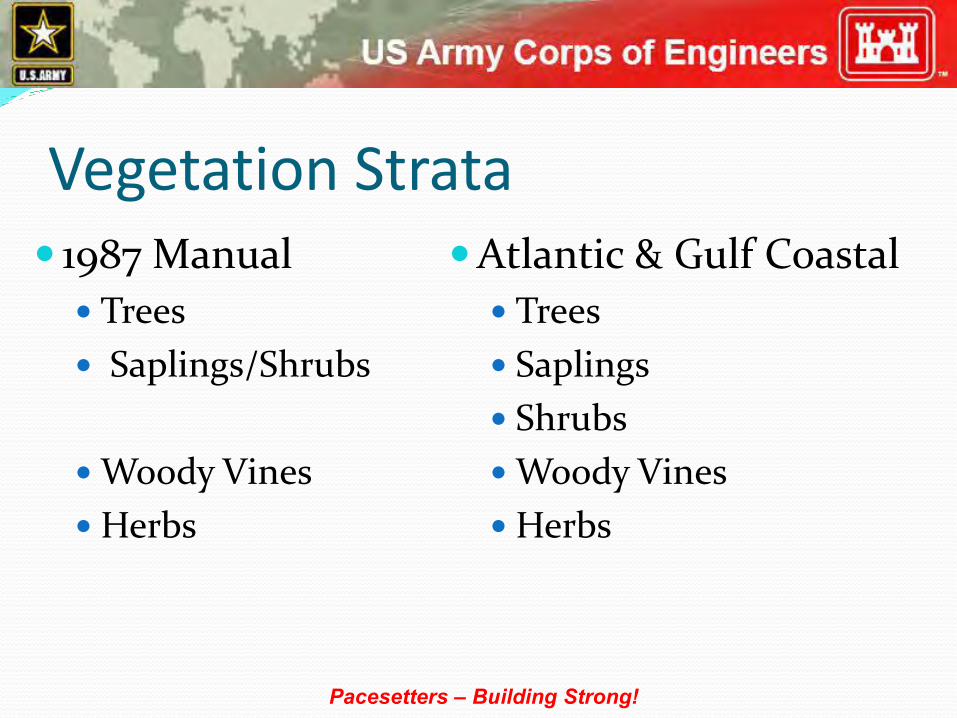
Vegetation Strata 1987 Manual
Trees
Saplings/Shrubs
Woody Vines
Herbs
Atlantic & Gulf Coastal
Trees
Saplings
Shrubs
Woody Vines
Herbs
Pacesetters – Building Strong!

Vegetation 1987 Manual
Use + and – modifiers on indicator status
Use 30-foot sampling radius for tree and woody vines strata
Use 5-foot radius for sapling/shrub and herb strata
Atlantic & Gulf Coastal
Drop + and – modifiers on indicator status
Use 30-foot sampling radius for tree, sapling, shrub, woody vine and herb strata
Pacesetters – Building Strong!

Vegetation 1987 Manual
50/20 Rule to select dominants
> 50% of dominants FAC or wetter
Use 50/20 rule and dominance determination across all strata
Atlantic & Gulf Coastal
50/20 Rule to select dominants
> 50% of dominants FAC or wetter (Dominance Test)
Use 50/20 rule within the stratum and the dominance test across all strata
Pacesetters – Building Strong!

Atlantic & Gulf Coastal Plain Species dominant in two or more strata are counted
two or more times in the dominance test
Use absolute percent cover in determining areal coverage and do not convert to relative cover
Absolute percent cover is used in the prevalence index calculation
Pacesetters – Building Strong!
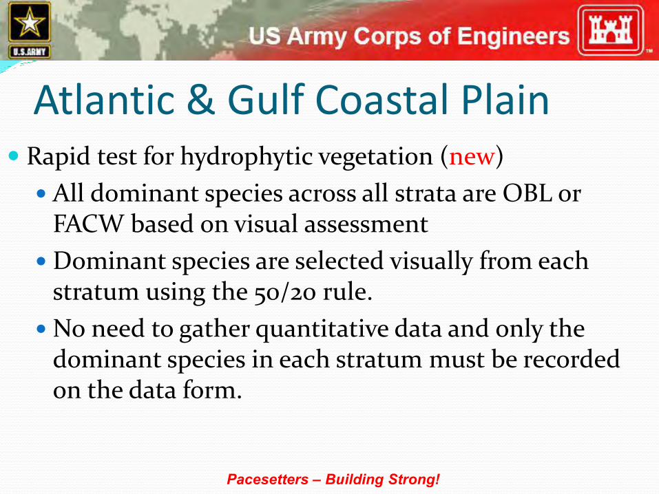
Atlantic & Gulf Coastal Plain Rapid test for hydrophytic vegetation (new)
All dominant species across all strata are OBL or FACW based on visual assessment
Dominant species are selected visually from each stratum using the 50/20 rule.
No need to gather quantitative data and only the dominant species in each stratum must be recorded on the data form.
Pacesetters – Building Strong!

Atlantic & Gulf Coastal Plain Dominance Test
Estimate absolute percent cover for every species
Rank all species in the stratum from most to least abundant
Calculate the total coverage for all species in the stratum (probably will not equal 100 percent)
Select species from the ranked list until the cumulative coverage exceeds 50 percent of the total absolute coverage for the stratum
Pacesetters – Building Strong!

Atlantic & Gulf Coastal Plain Dominance Test
If two or more species are equal in coverage, they all must be selected
Selected species are all dominants
Additionally, all other species that, by itself, is at least 20 percent of the total absolute cover in the stratum is also dominant
Repeat for each stratum
Pacesetters – Building Strong!

Pacesetters – Building Strong!

Atlantic & Gulf Coastal Plain Prevalence Index (PI)
Used when the plant community fails the dominance test but indicators of hydric soil and wetland hydrology are present
Identify and estimate absolute percent cover for each species in the stratum
Sum the percent cover for any species present in more than one stratum
Pacesetters – Building Strong!

Hydric Soils 1987 Manual
Dig hole and describe profile to 16 inches
Look at soil colors immediately below the A-horizon or 10 inches, whichever is shallower
Atlantic & Gulf Coastal
Dig hole and describe profile to 20 inches
Look at soil colors in the profile and match to NTCHS’s Field Indicators of Hydric Soils in the United States, Version 7.0
Pacesetters – Building Strong!

Pacesetters – Building Strong!

Atlantic & Gulf Coastal Plain During development of the indicators, soils in the
interior of wetlands were not always examined, therefore, there are wetlands that lack any of the approved hydric soil indicators in the wettest interior portions.
Delineators should concentrate sampling efforts near the wetland edge and if these soils are hydric, assume the interior soils are hydric even if they lack an indicator.
Pacesetters – Building Strong!

1987 Manual Hydric Soils Non-sandy Soils
Organic soils
Histic epipedons
Sulfidic material
Aquic or peraquic moisture regime
Reducing conditions
Soil colors
Soils appearing on hydric soils list
Iron and manganese concretions
Pacesetters – Building Strong!

1987 Manual Hydric Soils Sandy Soils
High organic matter content in the surface horizon
Streaking of subsurface horizons by organic matter
Organic pans
Pacesetters – Building Strong!

Atlantic and Gulf Coastal Plain Hydric Soils
All Soils
Histosol (A1)
Histic Epipedon (A2)
Black Histic (A3)
Hydrogen Sulfide (A4)
Stratified Layers (A5)
Organic Bodies (A6)
5 cm Mucky Mineral (A7)
Pacesetters – Building Strong!

Atlantic and Gulf Coastal Plain Hydric Soils
All Soils (cont’d)
Muck Presence (A8)
1 cm Muck (A9)
Depleted Below Dark Surface (A11)
Thick Dark Surface (A12)
Coast Prairie Redox (A16)
Pacesetters – Building Strong!

Atlantic and Gulf Coastal Plain Hydric Soils
Sandy Soils – loamy fine sand and coarser
Sandy Mucky Mineral (S1)
Sandy Gleyed Matrix (S4)
Sandy Redox (S5)
Stripped Matrix (S6)
Dark Surface (S7)
Polyvalue Below Surface (S8)
Thin Dark Surface (S9)
Pacesetters – Building Strong!

Atlantic and Gulf Coastal Plain Hydric Soils
Loamy and Clayey Soils – loamy very fine sand and finer
Loamy Mucky Mineral (F1)
Loamy Gleyed Matrix (F2)
Depleted Matrix (F3)
Redox Dark Surface (F6)
Depleted Dark Surface (F7)
Redox Depressions (F8)
Marl (F10)
Pacesetters – Building Strong!

Atlantic and Gulf Coastal Plain Hydric Soils
Loamy and Clayey Soils (cont’d)
Depleted Ochric (F11)
Iron-Manganese Masses (F12)
Umbric Surface (F13)
Delta Ochric (F17)
Reduced Vertic (F18)
Piedmont Floodplain Soils (F19)
Anomalous Bright Loamy Soils (F20)
Pacesetters – Building Strong!

Atlantic and Gulf Coastal Plain Hydric Soils
Problem Soils
2 cm Muck (A10)
Red Parent Material (TF2)
Very Shallow Dark Surface (TF12) (new)
Pacesetters – Building Strong!

Pacesetters – Building Strong!

Pacesetters – Building Strong!

Wetland Hydrology - Atlantic and Gulf Coastal Plain
Groups
A – Observation of surface water or saturated soils
B – Evidence of recent inundation
C – Evidence of current or recent soil saturation
D – Evidence from other site conditions or data
Pacesetters – Building Strong!

Wetland Hydrology 1987 Manual
(Primary) Inundation
Saturation within 12 inches of surface
Watermarks
Drift Lines
Sediment deposits
Drainage patterns in wetlands
Atlantic & Gulf Coastal (Primary) Surface water (A1)
High water table (A2)
Saturation (A3)
Water marks (B1)
Sediment deposits (B2)
Drift deposits (B3)
Algal mat or crust (B4)
Iron deposits (B5)
Pacesetters – Building Strong!

Wetland Hydrology 1987 Manual
(Primary)
Atlantic & Gulf Coastal (Primary)
Inundation visible on aerial imagery (B7)
Water-stained leaves (B9)
Aquatic fauna (B13)
Marl deposits (B15)
Hydrogen sulfide odor (C1)
Pacesetters – Building Strong!

Wetland Hydrology 1987 Manual
(Primary)
Atlantic & Gulf Coastal (Primary)
Oxidized rhizospheres along living roots (C3)
Presence of reduced iron (C4)
Recent iron reduction in tilled soils (C6)
Thin muck surface (C7)
Pacesetters – Building Strong!

Wetland Hydrology 1987 Manual
(Secondary)
Oxidized root channels in upper 12 inches
Water-stained leaves
Local soil survey data
FAC-Neutral Test
Other (explain)
Atlantic & Gulf Coastal (Secondary)
Surface soil cracks (B6)
Sparsely vegetated concave surface (B8)
Drainage patterns (B10)
Moss trim lines (B16)
Dry-season water table (C2)
Pacesetters – Building Strong!

Wetland Hydrology 1987 Manual
(Secondary) Atlantic & Gulf Coastal
(Secondary)
Crayfish burrows (C8)
Saturation visible on aerial imagery (C9)
Geomorphic position (D2)
Shallow aquitard (D3)
FAC-neutral test (D5)
Sphagnum moss (D8) (new)
Pacesetters – Building Strong!

Pacesetters – Building Strong!

Pacesetters – Building Strong!

Pacesetters – Building Strong!

Pacesetters – Building Strong!
Delineations vs. Determinations
A determination is qualitative in that it only provides an answer if there is a jurisdictional
area within the project area.
A delineation is quantitative in that it provides boundaries and acreage measurements for each
individual type of water of the United States present in the project area.

Pacesetters – Building Strong!
• Corps assigns project to PM and enters data
• Corps sends acknowledgement letter
• PM determines if site visit is necessary
• Conduct site visit for accuracy/adjustments
• Complete JD form for each aquatic resource
• Coordinate JD form with EPA if required
• PM writes memo and final letter

Pacesetters – Building Strong!
• Complete Data Sheets
• Delineation map with transects, sample points, aquatic resource and upland areas
• Acreages of wetlands, open waters, uplands
Corps of Engineers Expectations for Submitting
Delineation Reports

Pacesetters – Building Strong!
• Project boundaries must be staked/marked
• Aquatic resources must be staked/marked
• Transects, data points must be marked
• Delineator must be able to explain why an area is or is not called a wetland/water
Corps of Engineers Requirements for Field
Verifications

Pacesetters – Building Strong!
Expectations for Submitting Jurisdictional Determinations
• Letter requesting jurisdictional determination
• Vicinity map indicating project site boundaries
• Detailed map showing property boundaries
• Other supporting info such as Quad map, floodplain map, site photos

Pacesetters – Building Strong!

Pacesetters – Building Strong!
Restore and maintain the chemical, physical, and biological integrity of
the Nation’s waters

Pacesetters – Building Strong!
Power listed in the U.S. Constitution that allows Congress to regulate commerce with foreign Nations, and among the several states, and with Indian Tribes.
Pacesetters – Building Strong!
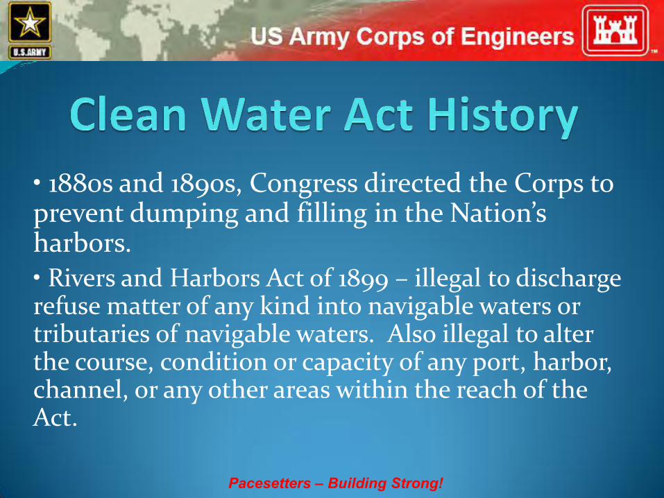
• 1880s and 1890s, Congress directed the Corps to prevent dumping and filling in the Nation’s harbors. • Rivers and Harbors Act of 1899 – illegal to discharge refuse matter of any kind into navigable waters or tributaries of navigable waters. Also illegal to alter the course, condition or capacity of any port, harbor, channel, or any other areas within the reach of the Act.

Pacesetters – Building Strong!
• 1912 – Public Health Service Act. Expanded mission of U.S. Public Health Service to study problems of sanitation, sewage, and pollution. • 1924– Oil Pollution Act. Prohibited intentional discharge of fuel oil into tidal waters. Repealed by 1972 Federal Water Pollution Control Act. • 1948 – Federal Water Pollution Control Act. Created comprehensive set of water quality programs. Enforcement limited to interstate waters.

Pacesetters – Building Strong!
• 1972 – Federal Water Pollution Control Act significantly reorganized and expanded.
• 1977 – With amendments, became the Clean Water Act. Through Section 404, mandated to develop effective program for controlling pollution of Nation’s 76 million acres of wetlands. One goal was to eliminate all discharges by 1985.

Pacesetters – Building Strong!
• 1985 – U.S. v. Riverside Bayview Homes – U.S. Supreme Court held that intermingled (adjacent) wetlands of navigable waters are subject to Section 404 of the Clean Water Act.

Pacesetters – Building Strong!
• 1986 – EPA clarified that waters of the U.S. at 40 CFR 328.3 also include waters which are or would be used as habitat by birds protected by the Migratory Bird Treaties; or which are or would be used as habitat by other migratory birds which cross state lines; or which are used as habitat for endangered species; or used to irrigate crops sold in interstate commerce. Also introduced non-waters reviewed earlier. Both in preamble to 1986 regulations.

Pacesetters – Building Strong!
• 2001 – Solid Waste Agency of Northern Cook County; 5-4 Decision in U.S. Supreme Court. Concluded you can not solely use the Migratory Bird Rule to exert jurisdiction over isolated waters.
• 2006 – Rapanos & Carabell; 5 separate opinions (one plurality, two concurring, two dissenting) in U.S Supreme Court with no single opinion commanding a majority. Vacated and remanded case back down to Sixth Circuit Court of Appeals.

Pacesetters – Building Strong!
Rapanos & Carabell Opinions
• Plurality – (Scalia, Roberts, Thomas, Alito) concluded that Section 404 should extend only to relatively permanent, standing or continuously flowing bodies of water connected to traditional navigable waters and to wetlands with a continuous surface connection to such relatively permanent waters.

Pacesetters – Building Strong!
Rapanos & Carabell Opinions
• Kennedy – concluded that wetlands are waters of the U.S. if the wetlands either alone or in combination with similarly situated lands in the region, significantly affect the chemical, physical, and biological integrity of other covered waters more readily understood as navigable. If the wetlands effects on water quality are speculative or insubstantial, they fall outside the statutory term ‘navigable waters’.

Pacesetters – Building Strong!
Rapanos & Carabell Opinions
• Dissenting – (Stevens, Souter, Ginsburg, Breyer) concluded that EPA’s and Corps’ interpretation of waters of the U.S. was a reasonable interpretation of the Clean Water Act.

Pacesetters – Building Strong!
Rapanos & Carabell Opinions
• When there is no majority opinion in a Supreme Court case, controlling legal principles may be derived from those principles espoused by five or more justices. Therefore, jurisdiction under the Clean Water Act exists if a waterbody meets the plurality or Kennedy’s standard.

Pacesetters – Building Strong!
Rapanos & Carabell Opinions
• Received guidance based on Rapanos & Carabell opinions on 5 June 2007.
• Received revised guidance on 2 December 2008.

Pacesetters – Building Strong!
• In response to Rapanos & Carabell opinions
• Coordination required with the EPA and Corps HQ on some waters
• JD sheet required for each aquatic resource
• New definitions
Traditional Navigable Waters (TNWs)
Relatively Permanent Waters (RPWs)

Pacesetters – Building Strong!
• Aquatic resources not coordinated with EPA (Agencies will assert jurisdiction over the following waters)
‐ Traditional navigable waters (TNWs)
‐ Wetlands adjacent to TNWs
‐ Relatively permanent waters (RPWs)
‐ Wetlands abutting RPWs

Pacesetters – Building Strong!
• Aquatic resources coordinated with EPA
(Agencies will decide jurisdiction based on a fact-specific analysis to determine if they have a significant nexus with a TNW)
‐ Tributaries above RPWs
‐ Wetlands adjacent to but not abutting RPWs
- Wetlands adjacent to non-RPWs
‐ Isolated wetlands

Pacesetters – Building Strong!
• Non-waters of the U.S.
(Agencies generally will not assert jurisdiction over these features)
- Swales or erosional features
- Ditches excavated wholly in an draining only uplands and that do not carry a relatively permanent flow of water.

Pacesetters – Building Strong!
• Significant Nexus Analysis - Assess the flow characteristics and functions of the tributary itself and the functions performed by all the wetlands adjacent to the tributary to determine if they significantly affect the chemical, physical, or biological integrity of the downstream TNW. - Includes consideration of hydrologic and ecologic factors such as volume, duration, frequency of flow, pollutant carrying capacity, flood storage, habitat, nutrient and organic carbon transfer capacity .

Pacesetters – Building Strong!
• Published proposed guidance in Federal Register on 2 May 2011 for 60 days. Comment period extended to 31 July 2011.

Pacesetters – Building Strong!
• HR 1310 – Frank Pallone – Clean Water Protection Act, 3 March 2009, amend the CWA by redefining Fill Material to mean any pollutant that replaces portions of waters of the United States with dry land or that changes the bottom elevation of a water body for any purpose and to exclude any pollutant discharged into water primarily to dispose of waste, mountaintop mining. NO ACTION

Pacesetters – Building Strong!
• S 787 – Russell Feingold – Clean Water Restoration Act, 2 April 2009, amend the CWA to replace the term "navigable waters“ with the term "waters of the United States,“ to the fullest extent that these waters, or activities affecting them, are subject to the legislative power of Congress under the Constitution. NO ACTION

Pacesetters – Building Strong!
• HR 5088 – James Oberstar – America’s Commitment to Clean Water Act, 21 April 2010, restore the definition of waters of the United States to that in place before the SWANCC and Rapanos decisions. (Replace Navigable waters with Waters of the United States) NO ACTION

Pacesetters – Building Strong!
• 14 April 2011 – 170 members of the House of Representatives sent a letter to President Obama asking him to end efforts to broaden Federal protection of wetlands.

Pacesetters – Building Strong!
• S 2245 – John Barrasso – Preserve the Waters of the United States Act, 28 March 2012, - Prohibits the USACE and the EPA from: (1) finalizing the proposed guidance described in the notice of availability and request for comments entitled "EPA and Army Corps of Engineers Guidance Regarding Identification of Waters Protected by the CWA"; or (2) using such guidance, or any substantially similar guidance, as the basis for any decision regarding the scope of the CWA or any rulemaking. Provides that the use of such guidance as the basis for any rule shall be grounds for vacation of such rule. NO ACTION

Pacesetters – Building Strong!
• HR 4965 – John Mica – Preserve existing rights with respect to waters of the U.S., 27 April 2012, Prohibits the USACE and EPA from: (1) finalizing, adopting, implementing, administering, or enforcing the proposed guidance described in the notice of availability and request for comments entitled "EPA and Army Corps of Engineers Guidance Regarding Identification of Waters Protected by the CWA"; or (2) using such guidance, or any substantially similar guidance, as the basis for any decision regarding the scope of the CWA or any rulemaking. Sent to House or Senate on 7 June 2012.

Pacesetters – Building Strong!
• HR 5325 – Rodney Frelinghuysen – Energy and Water Development Bill, 2 May 2012, None of the funds made available by this Act…may be used by the Corps of Engineers to develop, adopt, implement, administer, or enforce a change or supplement to the rule dated November 13, 1986, or guidance documents dated January 15, 2003 and December 2, 2008, pertaining to the definition of waters under the jurisdiction of the Federal Water Pollution Control Act. Passed House on 6 June 2012

Pacesetters – Building Strong!
• 33 CFR 331.2. • Approved JD - official USACE determination that jurisdictional waters of the U.S. or navigable waters of the U.S. are present or absent on a particular site or a written statement and map identifying the limits of waters. • Preliminary JD – written indication that there may be waters of the U.S. on a parcel or of the approximate locations of waters.

Pacesetters – Building Strong!
• Approved JD – appealable; may or may not delineate extent of jurisdiction; requires more information to confirm. • Preliminary JD – not appealable; assumes all aquatic resources on site are jurisdictional; not as stringent to confirm (approximate locations); cannot be used to determine no wetlands or no jurisdictional wetlands.

Pacesetters – Building Strong!

Pacesetters – Building Strong!

Pacesetters – Building Strong!

Pacesetters – Building Strong!

Pacesetters – Building Strong!

Pacesetters – Building Strong!

Pacesetters – Building Strong!

Pacesetters – Building Strong!

Pacesetters – Building Strong!

Pacesetters – Building Strong!

Pacesetters – Building Strong!

Pacesetters – Building Strong!

Pacesetters – Building Strong!

Pacesetters – Building Strong!

Pacesetters – Building Strong!

Pacesetters – Building Strong!
Pacesetters – Building Strong!
Pacesetters – Building Strong!
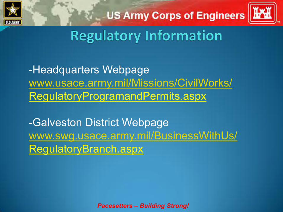
-Headquarters Webpage www.usace.army.mil/Missions/CivilWorks/ RegulatoryProgramandPermits.aspx -Galveston District Webpage www.swg.usace.army.mil/BusinessWithUs/ RegulatoryBranch.aspx


Pacesetters – Building Strong!

Atlantic & Gulf Coastal Plain Prevalence Index (PI)
Organize all species into groups according to their indicator status and sum their cover values within
Calculate the prevalence index using the formula:
A obl + 2A facw + 3A fac + 4A facu + 5A upl
PI = A obl + A facw + A fac + A facu + A upl
Plant community is hydrophytic if PI is 3.0 or less
Pacesetters – Building Strong!

Pacesetters – Building Strong!