how to use video imagery from underwater robots
TRANSCRIPT
1
Image captions/credits on Page 2.
Gulf of Mexico 2012 Expedition
Tools for Classroom Explorers
How to Use Video Imagery from Underwater Robots
FocusVideo from remotely operated vehicles for ocean exploration
Grade Level5-12 (Physical Science/Earth Science); see Learning Procedure, Adaptation to Different Grade Levels
Focus QuestionHow can images obtained by underwater robots be used to assist ocean exploration aboard the Okeanos Explorer?
Learning Objectivesn Students will describe typical applications and limitations of imagery
obtained with remotely operated vehicles (ROVs). n Students will demonstrate how lasers may be used to calibrate images
for size and distance measurements. n Students will analyze ROV imagery from the Okeanos Explorer to make
inferences about deep-ocean habitats and organisms.
Materialsq Copies of the Guide for Robot Imagery Investigations, one for each
student group q Copies of ImageJ Basics, one for each student group; see Learning
Procedure, Step 1c q Ruler, one for each student group Audio-Visual Materialsq (Optional) Interactive white board or video projector
Teaching TimeOne or two 45-minute class period; (more if students complete Supplemental Datasheets)
Seating ArrangementGroups of two to four students
Maximum Number of Students30
Key WordsNOAA Ship Okeanos Explorer
2
Image captions/credits on Page 2.
www.oceanexplorer.noaa.gov Gulf of Mexico Expedition 2012: How to Use Robot ImageryGrades 5-12 (Physical Science/Earth Science)
Ocean ExplorationRobotVideoImageJ
Background InformationExplanations and procedures in this lesson are written at a level appropriate to professional educators. In presenting and discussing this material with students, educators may need to adapt the language and instructional approach to styles that are best suited to specific student groups. On August 13, 2008, the NOAA Ship Okeanos Explorer was commissioned as “America’s Ship for Ocean Exploration;” the only U.S. ship whose sole assignment is to systematically explore our largely unknown ocean for the purposes of discovery and the advancement of knowledge. To fulfill this mission, an exploration strategy is used that involves three major activities: •Underwayreconnaissance; •Watercolumnexploration;and •Sitecharacterization.
Underway reconnaissance involves mapping the ocean floor and water column while the ship is underway, and using other sensors tomeasurechemicalandphysicalpropertiesofseawater.Watercolumn exploration involves making measurements of chemical and physical properties “from top to bottom” while the ship is stopped. In some cases these measurements may be made routinely at pre-selected locations, while in other cases they may be made to decide whether an area with suspected anomalies should be more thoroughly investigated. Site characterization involves more detailed exploration of a specific region, including obtaining high quality imagery, making measurements of chemical and physical seawater properties, and obtaining appropriate samples.
Key technologies involved with this strategy include:•Multibeamsonarmappingsystem;•CTDandotherelectronicsensorstomeasurechemicalandphysical
seawater properties; and•ARemotelyOperatedVehicle(ROV)capableofobtaininghigh-
quality imagery and samples in depths as great as 6,000 meters.
A fourth technological capability that is essential to the Okeanos Explorer exploration strategy is advanced broadband satellite communication. This capability provides the foundation for telepresence: technologies that allow people to observe and interact with events at a remote location. Telepresence allows live images to be transmitted from the seafloor to scientists ashore, classrooms, newsrooms and living rooms, and opens new educational opportunities
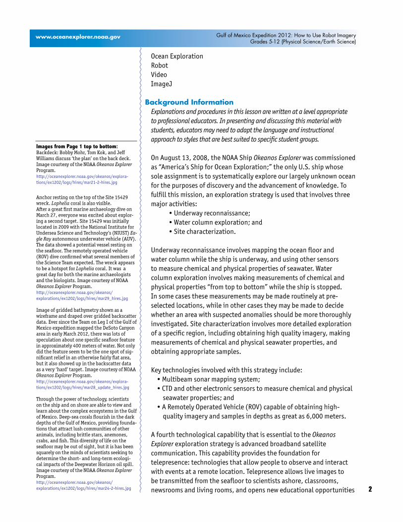
Images from Page 1 top to bottom:Backdeck: Bobby Mohr, Tom Kok, and Jeff Williams discuss ‘the plan’ on the back deck. Image courtesy of the NOAA Okeanos Explorer Program.http://oceanexplorer.noaa.gov/okeanos/explora-tions/ex1202/logs/hires/mar21-2-hires.jpg
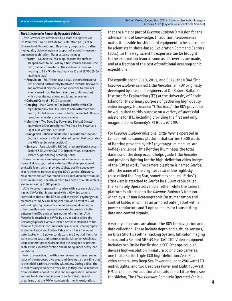
Anchor resting on the top of the Site 15429 wreck. Lophelia coral is also visible. After a great first marine archaeology dive on March 27, everyone was excited about explor-ing a second target. Site 15429 was initially located in 2009 with the National Institute for Undersea Science and Technology’s (NIUST) Ea-gle Ray autonomous underwater vehicle (AUV). The data showed a potential vessel resting on the seafloor. The remotely operated vehicle (ROV) dive confirmed what several members of the Science Team expected. The wreck appears to be a hotspot for Lophelia coral. It was a great day for both the marine archaeologists and the biologists. Image courtesy of NOAA Okeanos Explorer Program.http://oceanexplorer.noaa.gov/okeanos/explorations/ex1202/logs/hires/mar29_hires.jpg
Image of gridded bathymetry shown as a wireframe and draped over gridded backscatter data. Ever since the Team on Leg I of the Gulf of Mexico expedition mapped the DeSoto Canyon area in early March 2012, there was lots of speculation about one specific seafloor feature in approximately 400 meters of water. Not only did the feature seem to be the one spot of sig-nificant relief in an otherwise fairly flat area, but it also showed up in the backscatter data as a very ‘hard’ target. Image courtesy of NOAA Okeanos Explorer Program.http://oceanexplorer.noaa.gov/okeanos/explora-tions/ex1202/logs/hires/mar28_update_hires.jpg
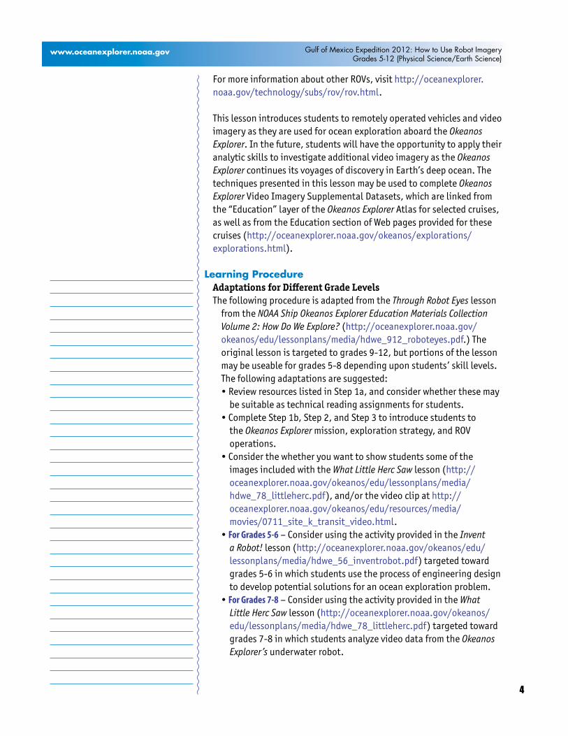
Through the power of technology, scientists on the ship and on shore are able to view and learn about the complex ecosystems in the Gulf of Mexico. Deep-sea corals flourish in the dark depths of the Gulf of Mexico, providing founda-tions that attract lush communities of other animals, including brittle stars, anemones, crabs, and fish. This diversity of life on the seafloor may be out of sight, but it is has been squarely on the minds of scientists seeking to determine the short- and long-term ecologi-cal impacts of the Deepwater Horizon oil spill. Image courtesy of the NOAA Okeanos Explorer Program. http://oceanexplorer.noaa.gov/okeanos/explorations/ex1202/logs/hires/mar24-2-hires.jpg
3
Image captions/credits on Page 2.
www.oceanexplorer.noaa.gov Gulf of Mexico Expedition 2012: How to Use Robot ImageryGrades 5-12 (Physical Science/Earth Science)
that are a major part of Okeanos Explorer’s mission for the advancement of knowledge. In addition, telepresence makes it possible for shipboard equipment to be controlled by scientists in shore-based Exploration Command Centers (ECCs). In this way, scientific expertise can be brought to the exploration team as soon as discoveries are made, and at a fraction of the cost of traditional oceanographic expeditions.
For expeditions in 2010, 2011, and 2012, the NOAA Ship Okeanos Explorer carried Little Hercules, an ROV originally developed by a team of engineers at Dr. Robert Ballard’s Institute for Exploration (IFE) at the University of Rhode Island for the primary purpose of gathering high quality video imagery. Nicknamed “Little Herc,” the ROV proved to be well-suited to this purpose on a variety of successful missions for IFE, including providing the first and only images of John Kennedy’s PT Boat, PT-109.
For Okeanos Explorer missions, Little Herc is operated in tandem with a camera platform that carries 2,400 watts oflightingprovidedbyHMI(hydrargyrummedium-arciodide) arc lamps. This lighting illuminates the total darkness of the deep ocean, helps guide Little Hercules, and provides lighting for the high-definition video images of the ROV at work. The camera platform is named Seirios, after the name of the brightest star in the night sky (also called the Dog Star, sometimes spelled “Sirius”). Little Herc is attached to Seirios by a 30-m cable called the Remotely Operated Vehicle Tether, while the camera platform is attached to the Okeanos Explorer’s traction winch by a 17 mm Oceanographic Instrumentation and Control Cable, which has an armored outer jacket with 3 power conductors and 3 optical fibers for transmitting data and control signals.
A variety of sensors are aboard the ROV for navigation and data collection. These include depth and altitude sensors, an Ultra Short Baseline Tracking System, full color imaging sonar, and a Seabird SBE 49 FastCAT CTD. Video equipment includes two Insite Pacific single CCD (charge-coupled device) high-resolution miniature color video cameras, one Insite Pacific triple CCD high-definition Zeus Plus video camera, two Deep Sea Power and Light 250-watt LED matrix lights, and two Deep Sea Power and Light 400-watt HMIarclamps.ForadditionaldetailsaboutLittleHerc,seethe sidebar, The Little Hercules Remotely Operated Vehicle.
The Little Hercules Remotely Operated VehicleLittle Hercules was developed by a team of engineers at
Dr. Robert Ballard’s Institute for Exploration (IFE) at the University of Rhode Island. Its primary purpose is to gather high quality video imagery in support of scientific research andoceanexploration.Majorsystemsinclude:
• Power – 2,800 volts (AC) supplied from the surface; stepped down to 120 VAC by a transformer aboard Little Herc; further converted in the electronics pressure housing to 24 VDC (8A maximum load) and 12 VDC (0.6A maximum load)
• Propulsion – Four Technadyne 1020 electric thrusters; two oriented horizontally to provide forward, backward, and rotational motion, and two mounted to form a V when viewed from the front (vertran configuration) which provides up, down, and lateral movement
• Onboard Control – PC104 computer• Imaging –MainCamera:OneInsitePacifictripleCCD
high-definition Zeus Plus HDTV camera with zoom and macro; Utility Cameras: Two Insite Pacific single CCD high-resolution miniature color video cameras
•Lighting – Two Deep Sea Power and Light 250-watt-equivalent LED matrix lights; Two Deep Sea Power and Light400-wattHMIarclamps
• Navigation – Ultrashort Baseline acoustic transponder (works in concert with ship-based system that calculates the ROV’s underwater position)
• Sensors – Paroscientific 8B7000 pressure/depth sensor; Seabird SBE 49 FastCAT CTD; Tritech PA500 altimeter; Tritech Super SeaKing scanning sonar
These components are integrated within an aluminum frame that is supported in water by a flotation package of syntactic foam, which provides slightly positive buoyancy that is trimmed to neutral by the ROV’s vertical thrusters. Mostelectronicsarecontainedina10-inchdiametertitaniumpressure housing. The ROV is rated to a depth of 4,000 meters, and in air weighs 1,200 pounds.
Little Hercules is operated in tandem with a camera platform named Seirios that is equipped with a HD video camera identicaltothatontheROV,aswellassixHMI(hydrargyrummedium-arc iodide) arc lamps that provide a total of 2,400 watts of lighting. Seirios has no buoyancy module, and is intentionally much heavier than water to provide a buffer between the ROV and surface motion of the ship. Little Hercules is attached to Seirios by a 30-m cable called the Remotely Operated Vehicle Tether. Seirios is attached to the Okeanos Explorer’s traction winch by a 17 mm Oceanographic Instrumentation and Control Cable which has an armored outer jacket with 3 power conductors and 3 optical fibers for transmitting data and control signals. A traction winch has large diameter grooved drums that are designed to protect cables from excessive friction and bending under heavy load conditions.
Prior to every dive, the ROV crew reviews multibeam sonar maps of the proposed dive area, and develops a track-line that is the initial path that the ROV will follow. During a dive, the ROV pilots may modify the track-line as they receive requests from scientists aboard the ship and in Exploration Command Centers to obtain video images of certain features and organisms that the ROV encounters during its exploration.
4
Image captions/credits on Page 2.
www.oceanexplorer.noaa.gov Gulf of Mexico Expedition 2012: How to Use Robot ImageryGrades 5-12 (Physical Science/Earth Science)
For more information about other ROVs, visit http://oceanexplorer.noaa.gov/technology/subs/rov/rov.html.
This lesson introduces students to remotely operated vehicles and video imagery as they are used for ocean exploration aboard the Okeanos Explorer. In the future, students will have the opportunity to apply their analytic skills to investigate additional video imagery as the Okeanos Explorer continues its voyages of discovery in Earth’s deep ocean. The techniques presented in this lesson may be used to complete Okeanos Explorer Video Imagery Supplemental Datasets, which are linked from the “Education” layer of the Okeanos Explorer Atlas for selected cruises, aswellasfromtheEducationsectionofWebpagesprovidedforthesecruises (http://oceanexplorer.noaa.gov/okeanos/explorations/explorations.html).
Learning ProcedureAdaptations for Different Grade LevelsThe following procedure is adapted from the Through Robot Eyes lesson
from the NOAA Ship Okeanos Explorer Education Materials Collection Volume 2: How Do We Explore? (http://oceanexplorer.noaa.gov/okeanos/edu/lessonplans/media/hdwe_912_roboteyes.pdf.) The original lesson is targeted to grades 9-12, but portions of the lesson may be useable for grades 5-8 depending upon students’ skill levels. The following adaptations are suggested:•ReviewresourceslistedinStep1a,andconsiderwhetherthesemay
be suitable as technical reading assignments for students. •CompleteStep1b,Step2,andStep3tointroducestudentsto
the Okeanos Explorer mission, exploration strategy, and ROV operations.
•Considerthewhetheryouwanttoshowstudentssomeoftheimages included with the What Little Herc Saw lesson (http://oceanexplorer.noaa.gov/okeanos/edu/lessonplans/media/hdwe_78_littleherc.pdf), and/or the video clip at http://oceanexplorer.noaa.gov/okeanos/edu/resources/media/movies/0711_site_k_transit_video.html.
•For Grades 5-6 – Consider using the activity provided in the Invent a Robot! lesson (http://oceanexplorer.noaa.gov/okeanos/edu/lessonplans/media/hdwe_56_inventrobot.pdf) targeted toward grades 5-6 in which students use the process of engineering design to develop potential solutions for an ocean exploration problem.
•For Grades 7-8 – Consider using the activity provided in the What Little Herc Saw lesson (http://oceanexplorer.noaa.gov/okeanos/edu/lessonplans/media/hdwe_78_littleherc.pdf) targeted toward grades 7-8 in which students analyze video data from the Okeanos Explorer’s underwater robot.
5
Image captions/credits on Page 2.
www.oceanexplorer.noaa.gov Gulf of Mexico Expedition 2012: How to Use Robot ImageryGrades 5-12 (Physical Science/Earth Science)
1. To prepare for this lesson, a. Review:•IntroductoryessaysfortheINDEX-SATAL2010
Expedition (http://oceanexplorer.noaa.gov/okeanos/explorations/10index/welcome.html); including Little Hercules ROV (http://oceanexplorer.noaa.gov/okeanos/explorations/10index/background/rov/rov.html);
•DailylogentriesforJuly7(http://oceanexplorer.noaa.gov/okeanos/explorations/10index/logs/july07/july07.html); July 24 (http://oceanexplorer.noaa.gov/okeanos/explorations/10index/logs/july24/july24.html); and August 6 (http://oceanexplorer.noaa.gov/okeanos/explorations/10index/logs/aug06/aug06.html).
You may want to assign one or more of these essays as background reading prior to beginning the rest of the lesson.
b. Review background information (above) about the Okeanos Explorer exploration strategy and technologies.
c. Review procedures on the Guide for Robot Imagery Investigations. If students will be using classroom computers, download ImageJ and the ImageJ Basics handout from http://rsbweb.nih.gov/ij/download.html and http://rsbweb.nih.gov/ij/docs/pdfs/ImageJ.pdf, respectively.
Also,downloadtheimagefilesEX2010.07.12_ROV_01.jpgandEX2010.07.12_ROV_02.jpgfromhttp://oceanexplorer.noaa.gov/okeanos/edu/resources/media/EX2010.07.12_ROV_01.jpg and http://oceanexplorer.noaa.gov/okeanos/edu/resources/media/EX2010.07.12_ROV_02.jpg, respectively. If students will not be using classroom computers, ensure that they will have access to these files.
d. Download images referenced in Step 2 and 3. You may also want to download examples of imagery from underwater robots from http://oceanexplorer.noaa.gov/okeanos/media/slideshow/flash_slideshow.html and http://oceanexplorer.noaa.gov/okeanos/media/slideshow/video_playlist.html.
2. Briefly introduce the NOAA Ship Okeanos Explorer, which is the only U.S. ship whose sole assignment is to systematically explore Earth’s largely unknown ocean for the purposes of discovery and the advancement of knowledge. Discuss why this kind of exploration is important (for background information, please see the lesson, Earth’s Ocean is 95% Unexplored: So What?; http://oceanexplorer.noaa.gov/okeanos/explorations/10index/background/edu/media/so_what.pdf). Review the overall strategy for ocean exploration used aboard Okeanos Explorer, and the primary technologies involved with this strategy (see background information above).
6
Image captions/credits on Page 2.
www.oceanexplorer.noaa.gov Gulf of Mexico Expedition 2012: How to Use Robot ImageryGrades 5-12 (Physical Science/Earth Science)
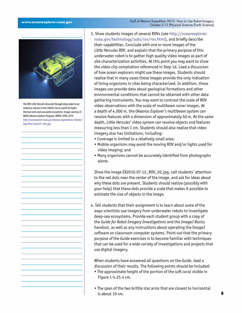
3. Show students images of several ROVs (see http://oceanexplorer.noaa.gov/technology/subs/rov/rov.html), and briefly describe their capabilities. Conclude with one or more images of the Little Hercules ROV, and explain that the primary purpose of this underwater robot is to gather high quality video images as part of site characterization activities. At this point you may want to show the video clip compilation referenced in Step 1d. Lead a discussion of how ocean explorers might use these images. Students should realize that in many cases these images provide the only indication of living organisms in sites being characterized. In addition, these images can provide data about geological formations and other environmental conditions that cannot be obtained with other data gathering instruments. You may want to contrast the scale of ROV video observations with the scale of multibeam sonar images. At a depth of 4,000 m, the Okeanos Explorer’s multibeam system can resolve features with a dimension of approximately 50 m. At the same depth, Little Hercules’ video system can resolve objects and features measuring less than 1 cm. Students should also realize that video imagery also has limitations, including:•Coverageislimitedtoarelativelysmallarea;•MobileorganismsmayavoidthemovingROVand/orlightsusedfor
video imaging; and•Manyorganismscannotbeaccuratelyidentifiedfromphotographs
alone. ShowtheimageEX2010.07.12_ROV_02.jpg,callstudents’attention
to the red dots near the center of the image, and ask for ideas about why these dots are present. Students should realize (possibly with your help) that these dots provide a scale that makes it possible to estimate the size of objects in the image.
4. Tell students that their assignment is to learn about some of the ways scientists use imagery from underwater robots to investigate deep-sea ecosystems. Provide each student group with a copy of the Guide for Robot Imagery Investigations and the ImageJ Basics handout, as well as any instructions about operating the ImageJ software on classroom computer systems. Point out that the primary purpose of the Guide exercises is to become familiar with techniques that can be used for a wide variety of investigations and projects that use digital imagery.
WhenstudentshaveansweredallquestionsontheGuide, lead a discussion of their results. The following points should be included:•Theapproximateheightoftheportionofthesoftcoralvisiblein
Figure 1 is 25.4 cm.
•Thespanofthetwobrittlestararmsthatareclosesttohorizontalis about 10 cm.
The ROV Little Hercules descends through deep water to an undersea volcano in the Celebes Sea to search for hydro-thermal vents and associated ecosystems. Image courtesy of NOAA Okeanos Explorer Program, INDEX-SATAL 2010http://oceanexplorer.noaa.gov/okeanos/explorations/10index/logs/hires/1june29_hires.jpg

7
Image captions/credits on Page 2.
www.oceanexplorer.noaa.gov Gulf of Mexico Expedition 2012: How to Use Robot ImageryGrades 5-12 (Physical Science/Earth Science)
•TheapproximatelengthoftheshrimpinthelowerleftofFigure2is9.2 cm.
•Theapproximatelengthofthevioletseacucumberintheuppercenter of Figure 2 is 10.9 cm; the sea cucumber may be somewhat larger than this, since it is farther away than the substrate where the laser dots are located.
•ThefishinFigure4is6metersfromtherobot,sincethebeamfromthe third laser converges with the beam from the parallel laser on the right, giving the appearance of only two dots on the fish.
•ThetotallengthofthefishinFigure4isapproximately30cm.
•ThefishinFigure5is3metersfromtherobot,sincethebeamfromthe third laser forms a dot that is 5.0 cm from the dot formed by the parallel laser on the right. The hint in Figure 6 is that that the angle q is constant, so the tangent of q is constant and equal to d / D, and also equal to b / B.
•ThetotallengthofthefishinFigure5isapproximately30cm.
•Errorsinvolvedwithvideofishsurveysincludeavoidanceoftherobot by some fish species; attraction to the robot by other species, which may also circle the robot and be counted more than once; and the exclusion of cryptic species that hide in crevices that are out of the camera’s view. In some cases, particularly when areas are being explored for the first time, it may not be possible to accurately identify every fish seen. This problem may arise when the characteristics used for identification require close inspection (such as the number of rays in a fin). Accurate identification also depends upon the experience of scientists watching the video; but occasionally, no one can identify a strange organism because it is a species new to science and has never been seen before!
•Thewidth(W)ofavideotransectmadewithacamerawhosehorizontal angle of view (A) is 90 degrees and an effective distance (D) of 5 m is:
W=2•(tan(0.5•A))•D=2•(tan45)•5=2•1•5=10m
•Thelengthofatransectthatbeginsat2.523456°Northlatitude,125.069212°Eastlongitude,andendsat2.525255Northlatitude,125.069146 East longitude is 0.2002 km.
•Usingvaluesfromquestions8and9,theareaofthetransectis 10m•200.2m=2002m2
8
Image captions/credits on Page 2.
www.oceanexplorer.noaa.gov Gulf of Mexico Expedition 2012: How to Use Robot ImageryGrades 5-12 (Physical Science/Earth Science)
To correct for the space that is outside the camera’s field of view, it is necessary to subtract
0.5•(W•D)=25m2 which is the shaded area shown in Figure 6.
•Thedistancebetweentheeyesofthecrustaceanisabout2.15cm;the length of the longest segment in the first right cheliped is about 7.80 cm.
•Theareaoccupiedbythelargewhitespongeinthelowerleftoftheimage is about 353 cm2.
•Theareaofthebranchingcoralintheupperrightoftheimageisabout 253 cm2.
Note that students’ results will vary depending upon how precisely they outline objects whose areas are to be estimated.
The BRIDGE Connectionwww.vims.edu/bridge/ – Scroll over “Ocean Science Topics” in the
menu on the left side of the page, then “Habitats” then select “Deep Ocean” for activities and links about deep ocean ecosystems. Scroll over “Research and Data Connections” in the menu on the left side of the page, then select “Virtual Expeditions” for activities and links to online activities about various types of exploration activities.
The “Me” ConnectionHave students write a brief essay about how robotic imagery might be of personal benefit.
Connections to Other SubjectsEnglish/LanguageArts,Mathematics,Physics
AssessmentStudents’ answers to worksheet questions and class discussions provide opportunities for assessment.
Extensions1. Visit the Okeanos Explorer Atlas (http://www.ncddc.noaa.gov/
website/google_maps/OkeanosExplorer/mapsOkeanos.htm)andWebpage (http://oceanexplorer.noaa.gov/okeanos/welcome.html) for reports, images, and other products from Okeanos Explorer cruises.
2. Visit http://www.marinetech.org/rov_competition/rov_video_2007.phpforavideofromtheMarineTechnologySociety’sstudentROVcompetition, and links to other sites about underwater robots.
3. For ideas about building your own underwater robots, see Bohm and Jensen (1998), Bohm (1997), and the Sea Perch Program (see Other Resources).
9
Image captions/credits on Page 2.
www.oceanexplorer.noaa.gov Gulf of Mexico Expedition 2012: How to Use Robot ImageryGrades 5-12 (Physical Science/Earth Science)
Other Relevant Lesson Plans from NOAA’s Ocean Exploration Program
Earth’s Ocean is 95% Unexplored: So What?(from the INDEX-SATAL 2010 Expedition)http://oceanexplorer.noaa.gov/okeanos/explorations/10index/background/edu/media/so_what.pdf
Focus: Importance of deep ocean exploration (Grades 5-6; Life Science/Earth Science)
Students describe at least three different deep ocean ecosystems; explain at least three reasons for exploring Earth’s deep ocean; and explain at least three ways that deep ocean ecosystems may benefit humans.
Where’s My ‘Bot? (from the Bonaire 2008: Exploring Coral Reef Sustainability with New Technologies Expedition)http://oceanexplorer.noaa.gov/explorations/08bonaire/background/
edu/media/wheresbot.pdf
Focus:MarineNavigation(Grades9-12;EarthScience/Mathematics)
Students estimate geographic position based on speed and direction of travel, and integrate these calculations with GPS data to estimate the set and drift of currents.
The following lessons are included in the NOAA Ship Okeanos Explorer Education Materials Collection Volume 2: How Do We Explore? http://oceanexplorer.noaa.gov/okeanos/edu/collection/hdwe.html.
To Explore Strange New Worldshttp://oceanexplorer.noaa.gov/okeanos/edu/lessonplans/media/hdwe_78_toexplore.pdf
Focus: Strategies for exploring unknown areas on Earth (Grades 5-6; Life Science/Physical Science/Earth Science)
Students describe requirements for explorations of unknown areas on Earth; discuss factors that influenced exploration strategies of the Lewis and Clark and Challenger Expeditions; describe the overall exploration strategy used aboard the NOAA Ship Okeanos Explorer; and describe how fractal geometry models natural systems, and how scale influences exploration strategy and results.
10
Image captions/credits on Page 2.
www.oceanexplorer.noaa.gov Gulf of Mexico Expedition 2012: How to Use Robot ImageryGrades 5-12 (Physical Science/Earth Science)
Invent a Robot!http://oceanexplorer.noaa.gov/okeanos/edu/lessonplans/media/hdwe_56_inventrobot.pdfFocus: Engineering Design (Grades 5-6; Physical Science)
Students discuss advantages and disadvantages of using underwater robots in scientific explorations, and how underwater robots are used aboard the Okeanos Explorer; use the process of engineering design to develop potential solutions for an ocean exploration problem; and explain the principle of hydraulic power transfer systems, and construct a robotic arm that demonstrates this principle.
What Little Herc Sawhttp://oceanexplorer.noaa.gov/okeanos/edu/lessonplans/media/hdwe_78_littleherc.pdf
Focus: Use of Robotics for Ocean Exploration (Grades 7-8; Life Science/Earth Science)
Students discuss the importance of robotic vehicle technology to the ocean exploration strategy used aboard the Okeanos Explorer; discuss how information from underwater robots about biological and geological features is relevant to the concept of biodiversity; and demonstrate a process for analyzing video data from the Okeanos Explorer’s underwater robot.
Other Resources The Web links below are provided for informational purposes only. Links outside of Ocean Explorer have been checked at the time of this page’s publication, but the linking sites may become outdated or non-operational over time.
http://oceanexplorer.noaa.gov/okeanos/edu/welcome.html –Webpage for the Okeanos ExplorerEducationMaterialsCollection
Anonymous.SeaPerchProgram[Internet].MassachusettsInstituteofTechnology Sea Grant Program. [cited January 12, 2011]. Available from http://seaperch.mit.edu/ – Includes detailed instructions for building a simple remotely operated underwater vehicle; based ondesignsfrom“BuildYourOwnUnderWaterRobotandOtherWetProjects” by Harry Bohm and Vickie Jensen
Bohm, H. and V. Jensen. 1998. Build Your Own Programmable Lego Submersible: Project: Sea Angel AUV (Autonomous Underwater Vehicle).WestcoastWords.39pages.
Bohm,H.1997.BuildYourOwnUnderwaterRobotandOtherWetProjects.WestcoastWords.148pages.
11
Image captions/credits on Page 2.
www.oceanexplorer.noaa.gov Gulf of Mexico Expedition 2012: How to Use Robot ImageryGrades 5-12 (Physical Science/Earth Science)
Moore,S.W.,H.Bohm,V.Jensen.2010.UnderwaterRobotics.MarineAdvancedTechnologyEducation(MATE)Center.Monterey,CA.769pp.
Correlations to A Framework for K-12 Science Education: Practices, Crosscutting Concepts, and Core Ideas
Framework for K-12 Science EducationDimension 1. Scientific and Engineering Practices
1. Asking questions (for science) and defining problems (for engineering)
2. Developing and using models4. Analyzing and interpreting data5. Using mathematics and computational thinking6. Constructing explanations (for science) and designing solutions
(for engineering)7. Engaging in argument from evidence8. Obtaining, evaluating, and communicating information
Dimension 2. Crosscutting Concepts1. Patterns2.Causeandeffect:Mechanismandexplanation3. Scale, proportion, and quantity4. Systems and system models
Dimension 3. Disciplinary Core IdeasPhysical SciencesCoreIdeaPS4:WavesandTheirApplicationsinTechnologiesfor
Information Transfer PS4.C: Information Technologies and Instrumentation.
Life Sciences Core Idea LS2: Ecosystems: Interactions, Energy, and Dynamics
LS2.A: Interdependent Relationships in EcosystemsEarth and Space Sciences
Core Idea ESS2: Earth’s SystemsESS2.A:EarthMaterialsandSystems
Engineering, Technology, and the Applications of ScienceCore Idea ETS2: Links Among Engineering, Technology, Science,
and Society ETS2.A: Interdependence of Science, Engineering, and
Technology
Correlations to Common Core State Standards for MathematicsGrade5-8:Measurement&DataHigh School: Algebra; Functions
Correlations to Common Core State Standards for English Language Arts
Grades 6-12 Reading: Informational Text
12
Image captions/credits on Page 2.
www.oceanexplorer.noaa.gov Gulf of Mexico Expedition 2012: How to Use Robot ImageryGrades 5-12 (Physical Science/Earth Science)
RI.9-10.4. Determine the meaning of words and phrases as they are used in a text, including figurative, connotative, and technical meanings.
Grades6-12LiteracyinHistory/SocialStudies,Science,&Technical Subjects: Follow precisely a multistep procedure when carrying out experiments, taking measurements, or performing technical tasks.
Ocean Literacy Essential Principles and Fundamental ConceptsEssential Principle 1. The Earth has one big ocean with many features.
Fundamental Concept b. An ocean basin’s size, shape and features (such as islands, trenches, mid-ocean ridges, rift valleys) vary due to the movement of Earth’s lithospheric plates. Earth’s highest peaks, deepest valleys and flattest vast plains are all in the ocean.
Essential Principle 5. The ocean supports a great diversity of life and ecosystems.
Fundamental Concept e. The ocean is three-dimensional, offering vast living space and diverse habitats from the surface through thewatercolumntotheseafloor.MostofthelivingspaceonEarth is in the ocean.
Fundamental Concept g. There are deep ocean ecosystems that are independent of energy from sunlight and photosynthetic organisms. Hydrothermal vents, submarine hot springs, and methane cold seeps rely only on chemical energy and chemosynthetic organisms to support life.
Essential Principle 6. The ocean and humans are inextricably interconnected.
Fundamental Concept b. From the ocean we get foods, medicines, and mineral and energy resources. In addition, it provides jobs, supports our nation’s economy, serves as a highway for transportation of goods and people, and plays a role in national security.
Fundamental Concept g. Everyone is responsible for caring for the ocean. The ocean sustains life on Earth and humans must live in ways that sustain the ocean. Individual and collective actions are needed to effectively manage ocean resources for all.
Essential Principle 7. The ocean is largely unexplored.
Fundamental Concept a. The ocean is the last and largest unexplored place on Earth—less than 5% of it has been explored. This is the great frontier for the next generation’s explorers and researchers, where they will find great opportunities for inquiry and investigation.
13
Image captions/credits on Page 2.
www.oceanexplorer.noaa.gov Gulf of Mexico Expedition 2012: How to Use Robot ImageryGrades 5-12 (Physical Science/Earth Science)
Fundamental Concept b. Understanding the ocean is more than a matter of curiosity. Exploration, inquiry and study are required to better understand ocean systems and processes.
Fundamental Concept c. Over the last 40 years, use of ocean resources has increased significantly, therefore the future sustainability of ocean resources depends on our understanding of those resources and their potential and limitations.
Fundamental Concept d. New technologies, sensors and tools are expanding our ability to explore the ocean. Ocean scientists are relying more and more on satellites, drifters, buoys, subsea observatories and unmanned submersibles.
Fundamental Concept f. Ocean exploration is truly interdisciplinary. It requires close collaboration among biologists, chemists, climatologists, computer programmers, engineers, geologists, meteorologists, and physicists, and new ways of thinking.
Send Us Your FeedbackIn addition to consultation with expedition scientists, the development of lesson plans and other education products is guided by comments and suggestions from educators and others who use these materials. Please send questions and comments about these materials to: [email protected].
For More InformationPaula Keener, Director, Education Programs NOAA Office of Ocean Exploration and ResearchHollingsMarineLaboratory331 Fort Johnson Road, Charleston SC 29412843.762.8818 843.762.8737 (fax) [email protected]
AcknowledgementsThis lesson was developed and written for NOAA’s Office of Ocean ExplorationandResearch(OER)byDr.MelGoodwin,ScienceandTechnology Consultant to OER’s Education Team.Design/layout:CoastalImagesGraphicDesign,Mt.Pleasant,SC.
CreditIf reproducing this lesson, please cite NOAA as the source, and provide the following URL: http://oceanexplorer.noaa.gov
14
Image captions/credits on Page 2.
Gulf of Mexico Expedition 2012: How to Use Robot ImageryGrades 5-12 (Physical Science/Earth Science)
www.oceanexplorer.noaa.gov
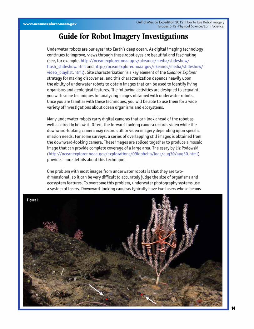
Guide for Robot Imagery InvestigationsUnderwater robots are our eyes into Earth’s deep ocean. As digital imaging technology continues to improve, views through these robot eyes are beautiful and fascinating (see, for example, http://oceanexplorer.noaa.gov/okeanos/media/slideshow/flash_slideshow.html and http://oceanexplorer.noaa.gov/okeanos/media/slideshow/video_playlist.html). Site characterization is a key element of the Okeanos Explorer strategy for making discoveries, and this characterization depends heavily upon the ability of underwater robots to obtain images that can be used to identify living organisms and geological features. The following activities are designed to acquaint you with some techniques for analyzing images obtained with underwater robots. Once you are familiar with these techniques, you will be able to use them for a wide variety of investigations about ocean organisms and ecosystems.
Manyunderwaterrobotscarrydigitalcamerasthatcanlookaheadoftherobotaswell as directly below it. Often, the forward-looking camera records video while the downward-looking camera may record still or video imagery depending upon specific mission needs. For some surveys, a series of overlapping still images is obtained from the downward-looking camera. These images are spliced together to produce a mosaic image that can provide complete coverage of a large area. The essay by Liz Podowski (http://oceanexplorer.noaa.gov/explorations/09lophelia/logs/aug30/aug30.html) provides more details about this technique.
One problem with most images from underwater robots is that they are two-dimensional, so it can be very difficult to accurately judge the size of organisms and ecosystem features. To overcome this problem, underwater photography systems use a system of lasers. Downward-looking cameras typically have two lasers whose beams
Figure 1.

15
Image captions/credits on Page 2.
Gulf of Mexico Expedition 2012: How to Use Robot ImageryGrades 5-12 (Physical Science/Earth Science)
www.oceanexplorer.noaa.gov
are parallel and a known distance apart. This places two bright dots on each image that establish the scale of the image. In Figures 1 and 2, the dots on the image are 10 cm apart. Using this information, estimate:
1. The approximate height of the portion of the large branching soft coral that is visible in Figure 1:
2. The span of the two brittle star arms that are closest to horizontal, not including
the portions that are twisted around the coral in Figure 1:
3. The approximate length of the shrimp in the lower left of Figure 2:
4. The approximate length of the violet sea cucumber in the upper center of Figure 2:
Note: the sea cucumber may be somewhat larger than this, since it is farther away than
the substrate where the laser dots are located.
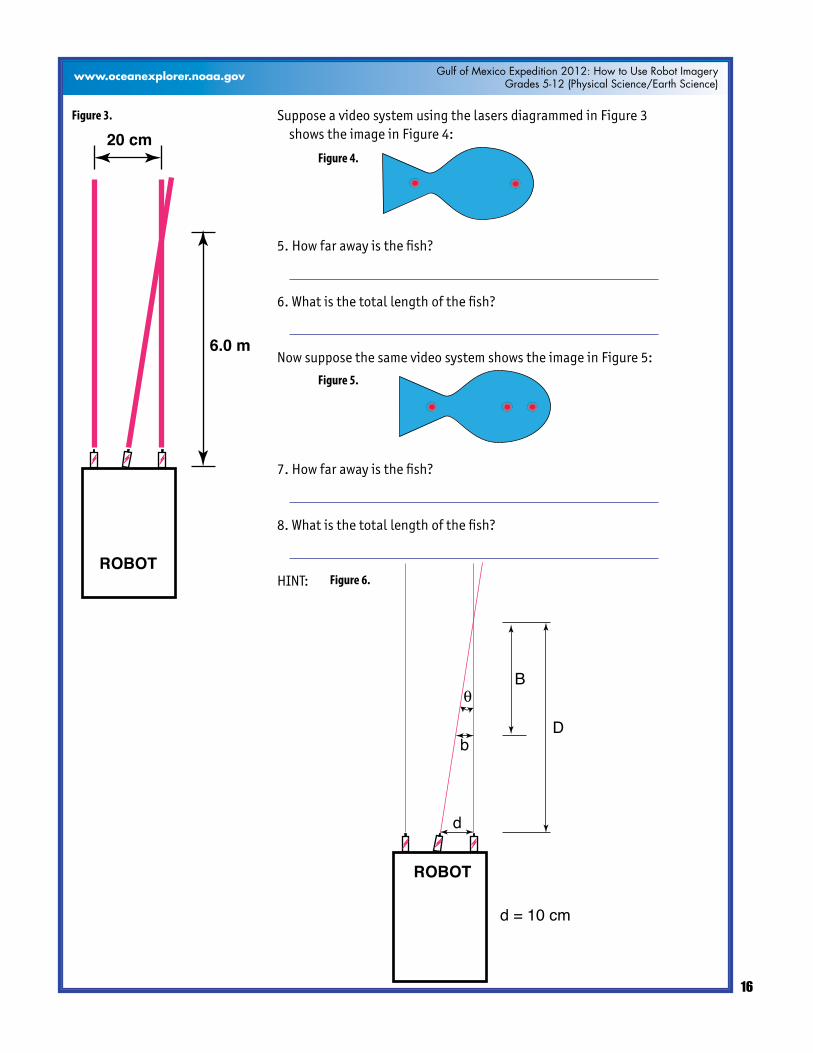
A similar system can be used in forward-looking video, but it is often important to be able to estimate distance as well. To provide this capability, a third laser is added to the system, in between the two parallel lasers. This additional laser is angled so that it converges with one of the parallel laser beams at a known distance in front of the robot (see Figure 3).
Figure 2.
16
Image captions/credits on Page 2.
Gulf of Mexico Expedition 2012: How to Use Robot ImageryGrades 5-12 (Physical Science/Earth Science)
www.oceanexplorer.noaa.gov
Suppose a video system using the lasers diagrammed in Figure 3 shows the image in Figure 4:
5. How far away is the fish?
6.Whatisthetotallengthofthefish?
Now suppose the same video system shows the image in Figure 5:
7. How far away is the fish?
8.Whatisthetotallengthofthefish?
HINT:
Figure 3.
ROBOT
20 cm
6.0 m
Figure 4.
Figure 5.
Figure 6.
ROBOT
θ
d
Db
B
d = 10 cm
17
Image captions/credits on Page 2.
Gulf of Mexico Expedition 2012: How to Use Robot ImageryGrades 5-12 (Physical Science/Earth Science)
www.oceanexplorer.noaa.gov
Fishes are a conspicuous part of many marine ecosystems, and ocean explorers often have questions about what kinds of fish inhabit certain areas, and how many fishes are there. Koenig (2001) describes a way to obtain this information that involves navigating an underwater robot along a series of transects (a transect is a path along which data are collected) while recording video from a forward-looking camera.Whenthetransectsarecompleted,thevideorecordingisreviewedandimaged fishes are identified and counted. The total counts for each species are divided by the total area of the transect to obtain an estimate of the density of each species. For example, if 50 fish belonging to a single species were counted in a video transect that covered 100 square meters, the density of that species would be 50 fish /100squaremeters=0.5fish/squaremeter.
9.Whatmightbesomeerrorsinvolvedwithsurveyingfishesinthisway?
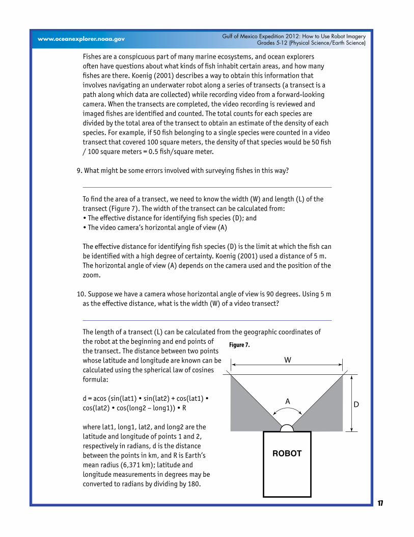
Tofindtheareaofatransect,weneedtoknowthewidth(W)andlength(L)ofthetransect (Figure 7). The width of the transect can be calculated from:
•Theeffectivedistanceforidentifyingfishspecies(D);and •Thevideocamera’shorizontalangleofview(A)
The effective distance for identifying fish species (D) is the limit at which the fish can be identified with a high degree of certainty. Koenig (2001) used a distance of 5 m. The horizontal angle of view (A) depends on the camera used and the position of the zoom.
10. Suppose we have a camera whose horizontal angle of view is 90 degrees. Using 5 m astheeffectivedistance,whatisthewidth(W)ofavideotransect?
The length of a transect (L) can be calculated from the geographic coordinates of the robot at the beginning and end points of the transect. The distance between two points whose latitude and longitude are known can be calculated using the spherical law of cosines formula:
d=acos(sin(lat1)•sin(lat2)+cos(lat1)•cos(lat2)•cos(long2–long1))•R
where lat1, long1, lat2, and long2 are the latitude and longitude of points 1 and 2, respectively in radians, d is the distance between the points in km, and R is Earth’s mean radius (6,371 km); latitude and longitude measurements in degrees may be converted to radians by dividing by 180.
Figure 7.
ROBOT
A D
W
18
Image captions/credits on Page 2.
Gulf of Mexico Expedition 2012: How to Use Robot ImageryGrades 5-12 (Physical Science/Earth Science)
www.oceanexplorer.noaa.gov
11.Ifourtransectbeganat2.523456°Northlatitude,125.069212°Eastlongitude,andendedat2.525255Northlatitude,125.069146°Eastlongitude,whatwasthe length (L) of the transect (Hint: 1. Be sure to use a calculator or spreadsheet program accurate to at least six decimal places.)
12.Nowthatyouknowthewidth(W)andlength(L)ofthetransect,howmuchareadid the transect include? (Hint: be sure to allow for the space that is outside the camera’s horizontal field of view.)
Basic analyses of video and single-frame images can be done by identifying and counting individual organisms, and by using laser scale dots to estimate the area coveredbytheimage.Muchmoresophisticatedanalysescanbedoneusingimageanalysis software. ImageJ is a very powerful image analysis program developed by the National Institutes of Health, and is free to the public. Links for downloading, tutorials, and full documentation are available at: http://rsbweb.nih.gov/ij/index.html.
Launch the ImageJ program, and open the file provided by your teacher. Review the ImageJ Basics handout, then try the following:
•Drawalinebetweenthetwolaserdots,andsetthemeasurementscaleasdescribedin the handout (remember the dots are 10 cm apart).
13.Adecapodcrustaceanisclearlyvisiblenearthebottomcenteroftheimage.Measurethe distance between the eyes, and the length of the longest segment in the first right cheliped (the leg with a claw near the front of the crab), and record your results. (Hint: Use the magnifying glass to enlarge the image for greater accuracy.)
14.Whatistheapproximateareaoccupiedbythelargewhitespongeinthelowerleftofthe image?
15.Noticethebranchingcoralintheupperrightoftheimage.Whatistheapproximatearea of this coral? (Outline the entire coral shape, not the individual branches.)