hood river plan 2006 -...
TRANSCRIPT
HOOD RIVERAGRICULTURAL WATER QUALITY
MANAGEMENT AREA PLAN
3rd Biennial Revision
December 12, 2006
Developed by the
HOOD RIVER LOCAL ADVISORY COMMITTEE
with assistance from
OREGON DEPARTMENT OF AGRICULTUREand
HOOD RIVER SOIL AND WATER CONSERVATION DISTRICT
Local Advisory Committee Members
Mike Oates, Chair Davinne McKeown-EllisBruce Decker, Vice Chair Brian NakamuraTim Annala Roger NelsonJerry Bryan Chuck ThomsenSteve Castagnoli Alexis VaivodaSteve Hunt Jim Wells
Hood River Agricultural Water Quality Management Area Plan December 12, 2006 Page 2
For copies of this Area Plan and Rules, please contact:Hood River SWCD3007 Experiment Station RoadHood River, Oregon 97031(541) 386-4588e-mail: [email protected]

Hood River Agricultural Water Quality Management Area Plan December 12, 2006 Page 3
TABLE OF CONTENTS
ACRONYMS & ABBREVIATIONS .......................................................................................5MAP - MANAGEMENT AREA ..............................................................................................6APPLICABILITY.....................................................................................................................7TEMPERATURE TMDL.........................................................................................................7INTRODUCTION ....................................................................................................................81: MANAGEMENT AREA .....................................................................................................9
Geographic Area and Physical Setting.....................................................................................9Land Use...............................................................................................................................10
2: WATER QUALITY CONCERNS .................................................................................... 12Beneficial Uses .....................................................................................................................12Water Quality Parameters of Concern ...................................................................................14Potential Contributors To Water Pollution.............................................................................16
3: MISSION, GOALS, AND OBJECTIVES ........................................................................ 174: MANAGEMENT MEASURES......................................................................................... 18
A. Management Intent..........................................................................................................18B. TDML Shade Targets1 .....................................................................................................18C. Recommended Management Practices .............................................................................19D. Area Rules.......................................................................................................................23
5: STRATEGIES TO ACHIEVE GOALS & OBJECTIVES .............................................. 26Voluntary Approach..............................................................................................................26Regulatory Measures.............................................................................................................27
6: MONITORING AND EVALUATION ............................................................................. 28Area Plan Implementation.....................................................................................................28Area Plan Progress ................................................................................................................28
7: ROLES AND RESPONSIBILITIES................................................................................. 29Area Plan Development ........................................................................................................29Area Plan Implementation.....................................................................................................29
8: DISCUSSION OF COSTS AND FUNDING..................................................................... 30CITED SOURCES.................................................................................................................. 30

Hood River Agricultural Water Quality Management Area Plan December 12, 2006 Page 4
Blank

Hood River Agricultural Water Quality Management Area Plan December 12, 2006 Page 5
ACRONYMS & ABBREVIATIONS
Area Plan - Hood River Agricultural Water Quality Management Area Plan
Area Rules - Oregon Administrative Rules 603-095-1100 through 603-095-1160
cfs - cubic feet per second
DEQ - Oregon Department of Environmental Quality
DSL - Department of State Lands
LAC - Hood River Local Advisory Committee
Management Area - Hood River Agricultural Water Quality Management Area
NOAA’s Fisheries Service – National Oceanic and Atmospheric Administration National MarineFisheries Service
NRCS - USDA Natural Resources Conservation Service
NTUs - Nephelometric Turbidity Units
OAR - Oregon Administrative Rules
ODA - Oregon Department of Agriculture
ODF - Oregon Department of Forestry
ORS - Oregon Revised Statutes
OSU - Oregon State University
SWCD - Soil and Water Conservation District
TMDL - Total Maximum Daily Load
USDA - United States Department of Agriculture
Hood River Agricultural Water Quality Management Area Plan December 12, 2006 Page 6
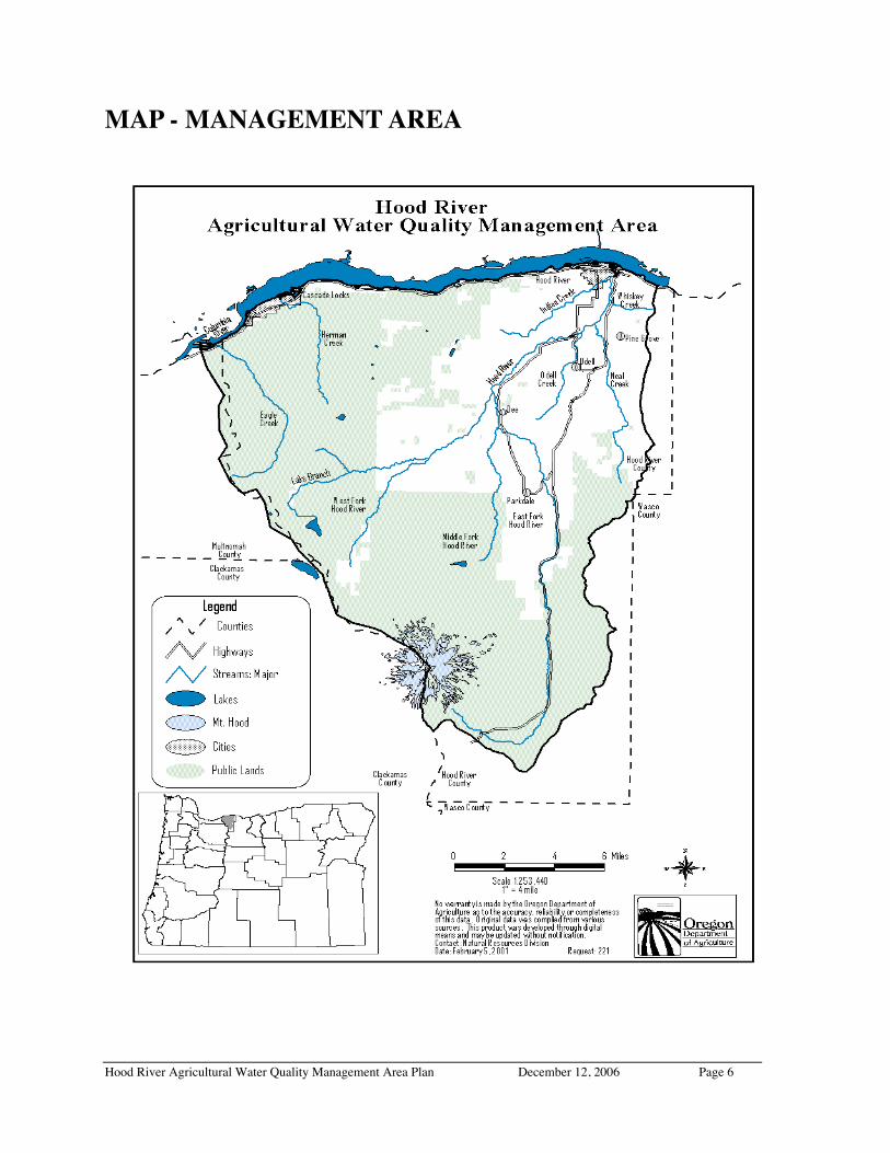
MAP - MANAGEMENT AREA
Hood River Agricultural Water Quality Management Area Plan December 12, 2006 Page 7
FOREWORDThis Hood River Agricultural Water Quality Management Area Plan (Area Plan) providesguidance for addressing agricultural water quality issues in the Hood River AgriculturalWater Quality Management Area (Management Area). The purpose of this Area Plan is toidentify strategies to reduce water pollution from agricultural lands through a combinationof educational programs, suggested land treatments, management activities, andmonitoring.
The provisions of this Area Plan do not establish legal requirements or prohibitions.
The Oregon Department of Agriculture (ODA) will exercise its enforcement authority forthe prevention and control of water pollution from agricultural activities under OregonAdministrative Rules for the Hood River Management Area (603-095-1100 through603-095-1160) and statewide enforcement procedures provided in Oregon AdministrativeRules 603-090-0060 through 603-090-0120.
APPLICABILITYThis Area Plan applies specifically to agricultural activities on all agricultural, rural, and forestlands within the Hood River Agricultural Water Quality Management Area that are not owned bythe federal government or are Tribal Trust Lands. The Area Plan applies to agricultural lands incurrent use, those lying idle or on which management has been deferred, and lands (like privateroads) not strictly in agricultural use but that support agricultural activities.
Activities governed by the Forest Practices Act are outside the jurisdiction of this Area Plan.Pesticide use is governed by the Pesticide Control Act (ORS 634); those laws are administeredby ODA Pesticides Division. At the time this Area Plan was being developed, activities ofirrigation districts that affect water quality were being regulated by the Oregon Department ofEnvironmental Quality (DEQ).
TEMPERATURE TMDLThe Oregon Department of Environmental Quality (DEQ), in accordance with the Federal CleanWater Act, is required to establish “Total Maximum Daily Loads” (TMDLs) for pollutants on the303(d) list. The 303(d) list consists of streams that violate state water quality standards. TMDLsset maximum limits on the amount of pollutants allowed to enter water bodies so that waterquality standards can be met.
Each jurisdiction (such as agriculture, forest lands, Federal lands, and urban areas) is allocated aportion of the TMDLs. This amount is the jurisdiction’s Load Allocation. Each jurisdictiondevelops pollution control plans and programs designed to achieve the load allocations.
A TMDL for temperature (based on the 1998 303(d) list) was developed for the ManagementArea and was approved by EPA in January, 20021. The TMDL includes solar radiation loads (inlangleys per day). These loads have been translated into Effective Shade surrogate measures,which are more useful for guiding nonpoint source management practices. The Hood RiverAgricultural Water Quality Management Area Plan is the implementation plan for Agriculture’sLoad Allocation.

Hood River Agricultural Water Quality Management Area Plan December 12, 2006 Page 8
INTRODUCTIONThis Hood River Agricultural Water Quality Management Area Plan (Area Plan) addressessediment, nutrient, bacteria, toxics, temperature, pH, and flow concerns related to agriculturalactivities on non-Federal and non-Tribal Trust lands in the Hood River Agricultural WaterQuality Management Area (Management Area). Temperature and pH were on the OregonDepartment of Environmental Quality’s 1998 303(d) list of “water quality limited” streams in theManagement Area; pesticides (chlorpyrifos and azinphos methyl), iron and zinc are on the 2002list. Additional metals are on the draft 2004/06 list. Temperature concerns were addressed bythe 2002 TMDL.
The Oregon Agricultural Water Quality Act, passed as Senate Bill 1010 in 1993 (ORS 568.900-568.933), and Oregon Administrative Rules (OAR 603-090) outline the process for thedevelopment and implementation of Agricultural Water Quality Management Area Plans toprevent and control water pollution resulting from agricultural activities and soil erosion. Theprocess includes the formation of a Local Advisory Committee that consists primarily oflandowners in the affected area to assist the Oregon Department of Agriculture (ODA) in thedevelopment of the Area Plan and Rules.
In November 1999, the Hood River Local Advisory Committee (LAC) was convened by ODA.They are assisted by the Hood River Soil and Water Conservation District (SWCD). LACmembers represent the interests of local landowners (orchardists, livestock growers, and small-acreage farmers), Hood River Growers-Shippers Association, fruit packing houses andagricultural businesses, irrigation districts, Hood River Watershed Group, fish biologists, HoodRiver County Board of Commissioners, Confederated Tribes of the Warm Springs Reservation,and the Hood River SWCD. Local Advisory Committee members are:
Mike Oates, Chair: Odell, orchardBruce Decker, Vice Chair: Wilbur-Ellis fieldmanTim Annala: Hood River, orchardJerry Bryan: west valley, Farmers Irrigation DistrictSteve Castagnoli: OSU ExtensionSteve Hunt: Dee, orchard
Davinne McKeown-Ellis: Pine Grove, llamasBrian Nakamura: Willow Flat, orchardRoger Nelson: Parkdale, blueberriesChuck Thomsen: County Commissioner; orchardAlexis Vaivoda: Tribal fish biologistJim Wells: Pine Grove, orchard
The LAC receives additional technical support from the USDA Natural Resources ConservationService (NRCS); USDA Farm Service Agency; United States Forest Service; OregonDepartments of Agriculture, Fish and Wildlife, Forestry, and Environmental Quality; Mid-Columbia Agricultural Research and Extension Center; and others.
The goal of this Area Plan is to prevent and control water pollution and soil erosion throughvoluntary activities by agricultural landowners, aided by information and technical and financialassistance from local, state, and federal agencies, and other sources. ODA will use regulatorymeasures as a last resort when voluntary approaches do not adequately correct conditionscausing water quality problems.
This Area Plan will address conditions affecting water quality that result from the agriculturalmanagement of:
• Streamsides• Livestock• Cultivated lands• Agricultural wastes• Nutrients, farm chemicals, and pesticides• Irrigation water and surface drainage

Hood River Agricultural Water Quality Management Area Plan December 12, 2006 Page 9
1: MANAGEMENT AREA
Geographic Area and Physical Setting
LocationThe Hood River Agricultural Water Quality Management Area (Management Area)encompasses approximately 450 square miles in north-central Oregon and includes thecommunities of Cascade Locks, Hood River, Pine Grove, Odell, Dee, and Parkdale (see map).The Management Area includes most of Hood River County and is comprised of the Hood Riverdrainage and all other tributaries to the Columbia River between and including Eagle Creek tothe west and Fir Mountain to the east. Approximately one third of the land is County orprivately owned. Almost all the remaining lands are Federally owned and managed by the USForest Service. Elevations in the Management Area range from 74 feet to 11,245 feet above sealevel.
The Management Area is located in the transition zone between weather dominated by wetmarine airflow to the west and the dry continental climate of eastern Oregon2. About two-thirdsof the Hood River drainage is within the Cascades ecoregion and has a moist temperate climate.The northeast portion is in the dry Eastern Cascades Slopes and Foothills ecoregion. Meanannual precipitation ranges from 130 inches on the upper west boundary in the Cascade Range toless than 30 inches in the lower east valley.
Hydrology2
One quarter of the Management Area consists of tributaries to the Columbia that flow almostexclusively through Federal lands managed by the United States Forest Service.
The Hood River drains 339 square miles (217,340 acres) of the Management Area and consistsof three main forks (West, Middle, and East) that converge into the mainstem Hood River nearRiver Mile 12.0. The drainage contains approximately 400 miles of perennial stream channel ofwhich an estimated 100 miles is accessible to anadromous fish.
Five tributaries of the three forks are fed by glacial sources that drain approximately one third ofthe total glacial ice on Mt. Hood. During high flows, large amounts of bedload and sediment aretransported in these tributaries and in the mainstem. Glacial melt increases water turbidity in theform of suspended silt and glacial flour during summer and early fall. Glacial sediment is moreprevalent in the Middle and East Forks and Hood River mainstem, while glacial sediment in theWest Fork is contributed by a single small tributary, Ladd Creek. Natural disturbances thatcontribute significant amounts of sediment to stream channels include landslides and debristorrents that originate on glacial moraines and steep slopes of Mt Hood.
The majority of stream channels in the Management Area are moderate to high gradient andconfined by terraces or narrow v-shaped valleys with limited floodplain area. Notably, much ofthe mainstem Hood River, the East Fork and portions of the West Fork consist of low gradientreaches of 2.5% or less. Forty one percent of the total stream length consists of habitat typesclassified as a sediment source, 36% as sediment transport, and 23% as sediment depositionzones.
Typical of many Cascade mountain streams, the hydrology of the Management Area ischaracterized by highly variable streamflow and rapid storm runoff. The mean annual flow inthe Hood River is 1,079 cfs at Tucker Bridge (River Mile 6.1). The record flood is reported as33,000 cfs (December 1964), while the minimum 7-day average was 155 cfs (September 1994).Mean monthly flows range from 392 cfs in September to a high of 1,747 cfs in January.
Hood River Agricultural Water Quality Management Area Plan December 12, 2006 Page 10
Snowmelt generally begins during April. Many tributaries have very low summer flows, whiletributaries with glacial sources maintain higher flows.
Natural disturbances occurring in the Management Area include floods, fires, mudflows,landslides, and insect and botanical disease epidemics. Rain-on-snow floods are commondisturbance events. Periodically, natural dams created by terminal moraines at receding glacierson Mt. Hood break and cause floods and debris flows; many of these events are triggered byintense rainstorms. Landslides are common but not frequent events.
Hydrologic Modifications2
The natural flow regime of the Hood River drainage has been modified by irrigation withdrawalsand hydropower diversions. Consumptive water use between July and September is estimated at37% (220 cfs) of natural flow at the Hood River mouth. Reservoir storage is limited to 4,600acre-feet, or less than 1% of mean annual discharge. Laurance Lake at Clear Branch Dam is thelargest reservoir with a volume of 3,550 acre-feet storage for irrigation. Water rights held byfive irrigation districts total 588 cfs. The three major irrigation districts have invested to varyingdegrees in measures to conserve water and decrease operation and management costs, byreplacing open ditch, canal segments, and low-efficiency pipe with pressurized pipe.
The single largest diversion in the Hood River drainage occurs at Powerdale HydroelectricProject four miles south of the City of Hood River, where PacifiCorp withdraws up to 500 cfscontinuously from the Hood River. Presently between 25% and 79% of the Hood River’smonthly average streamflow is diverted from the Powerdale bypass reach. Municipal diversionsinclude the cities of The Dalles and Hood River. Four water districts serve rural areas or towns,and instream water rights are established at seven locations but are consistently met at only twoof these due to senior water rights. The Management Area is closed to new surface waterwithdrawals from April 15 to September 30, although exceptions are made in the administrativerules for some projects such as off-stream watering facilities for livestock.
Land Use
Historical2
Native Americans maintained huckleberry fields and trails later used by non-Native settlers, andcollected plants, hunted game, and fished in tributaries and main forks of the Hood River.Native houses were located at the Hood River mouth and vicinity. The Management Area wasincluded in the one million acres of land ceded to the U.S. in the 1855 Treaty with the Tribes ofMiddle Oregon by ancestors of the Confederated Tribes of the Warm Springs Reservation.
Sheep herding and cattle grazing were common on the upper slopes of the East Fork in meadowareas during early settlement prior to 1900. Around 1880, orchards and strawberry fields beganto progress up the valley as the natural landscape pattern of coniferous forest and riparian habitatnetworks was transformed into pasture and fruit crops. Wet areas were drained for agricultureand other land uses throughout much of the valley. Many wetlands and stream channels weredrained or diverted to reduce saturated soil conditions, and roads were constructed adjacent toand across streams. Possibly the biggest factor altering the vegetative pattern in the lower HoodRiver drainage was the growth of the fruit industry, where orchards have replaced coniferousforest and riparian habitat networks.
Water-powered sawmills, dams and mill ponds operated in Neal and Green Point Creeks and thelower East Fork and mainstem Hood River as early as 1861. Logs were transported in rivers orby flumes, horse teams, and later railroads. Before 1900, streams were diverted into hand-dugcanals and ditches for irrigation.

Hood River Agricultural Water Quality Management Area Plan December 12, 2006 Page 11
Historic timber practices have resulted in riparian corridors and stream channels lacking the largewoody debris needed to build and maintain high quality fish habitat. Extensive use of splashdams occurred through the 1940s. During the 1960s and 1970s, stream cleanout was encouragedand believed to benefit fish passage. The present deficiency in instream large wood debris hasreduced the amount and quality of pool habitat, side channels and slow water areas, hiding cover,and limits retention of spawning-size gravel within low water stream channels.
Current2
The economy is based on agriculture (primarily pear and apple orchards), forestry, recreation andtourism, the latter having overtaken forest products as the second largest economic contributor.Approximately 15,000 acres of orchard and 2,000 acres of pasture are actively irrigated. Anestimated 10% of Hood River valley orchardists use soil moisture sensors to improve orchardwater efficiency. The Integrated Fruit Production program promotes environmentallysustainable orchard practices including reduced pesticide, fertilizer, and water use.
The majority of livestock operations occur on small acreage farms of less than 20 acres. Forestrycontinues to be an important economic activity. Hood River County owns approximately 30,000acres dedicated as industrial forest or 15% of the Hood River drainage. Longview FibreCompany owns 22,000 acres held in the Neal Creek drainage, the West Fork Hood River, andalong Tony Creek. About two-thirds of the Management Area is within the Mt. Hood NationalForest where timber harvest is guided by the 1994 Northwest Forest Plan.
The Hood River County population is growing approximately 2% per year. Land use isgoverned by the 1984 County Comprehensive Land Use Plan, which established urban growthboundaries for the cities of Hood River and Cascade Locks and the towns of Parkdale, Odell andMt. Hood. Conversion of forest and pasture to single-family residential development isincreasing in rural lands outside of the urban growth areas. Visitor use of the Management Areahas multiplied due to regional population growth and the increasing popularity of outdoorrecreation and tourism. These trends are expected to continue.

Hood River Agricultural Water Quality Management Area Plan December 12, 2006 Page 12
2: WATER QUALITY CONCERNS
The Federal Clean Water Act requires that each state designate the beneficial uses of water,select water quality parameters most directly related to the beneficial uses, and set standards forthose parameters.
Beneficial Uses
Beneficial uses for the Management Area include domestic and industrial water supplies,irrigation, livestock watering, aquatic life, recreation, aesthetics, and hydropower. Of these,‘salmonid fish rearing and spawning’, ‘drinking water’, and ‘human contact recreation’ are themost sensitive uses. Bacterial contamination is the greatest concern for swimming and othertypes of human water contact; drinking water is affected primarily by toxics and nitrates.However, aquatic life is affected by temperature, sedimentation, turbidity, toxics, nutrients, pH,and dissolved oxygen.
Because aquatic species are so sensitive to a variety of pollutants, they are often viewed as anindicator species of water quality. Therefore, in this section, the Area Plan will focus onsalmonid numbers and habitat requirements.
SalmonidsThe abundance and range of anadromous fish in the Hood River Watershed has declinedcompared to historical conditions. Native spring chinook, Coho and fall chinook stocks havebecome extinct. Bull trout and steelhead were listed as Threatened in 1998 under the FederalEndangered Species Act. The sea-run cutthroat population is proposed for listing as aThreatened Species.
Table 1. Distribution and status of salmonids in the Hood River drainage.SPECIES PRIMARY SPAWNING,
HOLDING AND REARINGAREAS
STATUS OF WILD POPULATION
ANADROMOUS SALMONIDSSpring chinooksalmon
Elk CreekMcGee CreekWest Fork Hood RiverMiddle Fork Hood RiverMainstem Hood River
Native stock extinct. Hatchery supplementationongoing to reintroduce spring chinook usingDeschutes stock. Current natural productionlimited.
Summer steelhead West Fork and tributariesMainstem Hood River
Threatened Species - listed by NOAA’s FisheriesService. Hatchery supplementation ongoing tostrengthen wild run.
Winter steelhead East Fork and tributariesNeal CreekGreen Point CreekMiddle Fork and tributariesMainstem Hood River
Threatened Species - listed by NOAA’s FisheriesService. Hatchery supplementation ongoing tostrengthen wild run.
Fall chinook salmon Mainstem Hood RiverEast Fork Hood River
Threatened Species - listed by NOAA’s FisheriesService. Limited natural spawning from hatcherystrays or their progeny.
Coho salmon East Fork and tributariesMiddle Fork and tributariesMainstem Hood RiverNeal Creek and tributaries
Threatened Species - listed by NOAA’s FisheriesService. Limited natural spawning from hatcherystrays or their progeny.
Sea-run cutthroattrout
East Fork and tributariesMiddle Fork and tributariesMainstem Hood River
State Sensitive species (ODFW). Proposed forThreatened Species listing by NOAA’s FisheriesService. Severely depressed (less than 100spawners).
Hood River Agricultural Water Quality Management Area Plan December 12, 2006 Page 13
Neal Creek and tributaries spawners).RESIDENT SALMONIDSRainbow trout Entire Hood River drainageCutthroat trout Entire Hood River drainageBull trout Middle Fork Hood River
Mainstem Hood RiverClear BranchCoe Branch and tributariesPinnacle CreekCompass Creek
Threatened species – listed by USFWS
Water temperatures are critical to salmonid growth and survival at all life stages. Warmstream temperatures increase stress and disease, raise metabolism and lower growth rates, andenhance conditions for introduced non-native predators. Temperature affects the dissolvedoxygen potential in water; the warmer the water, the less dissolved oxygen it can hold.Temperature controls the rate of many chemical reactions including the equilibrium betweenammonium (NH4) and un-ionized ammonia NH3 (toxic form). Lethal temperatures for adultsalmonids vary according to a variety of factors - but are generally reported in the range of 70 to77˚F. Salmonid eggs and juveniles are much more sensitive to high temperatures.
Generally, water temperatures above 55˚F inhibit salmonid spawning, egg incubation and fryemergence from the gravel. However, salmonids have successfully survived in some areaswhere natural water temperatures are higher. Egg development and the subsequent timing ofemergence are closely associated with stream temperatures. Juvenile rearing and growth may beimpaired by temperatures greater than 64˚F. Optimal water temperature for bull trout is less than50˚F, but some life stages commonly are found in temperatures in the mid-50s.
The TMDL adopted by EPA in 2002 identified shade targets that are to be met on ManagementArea streams1. These targets are addressed in Section 4.
Sediments carried in streams can adversely affect aquatic life by reducing light penetration andvisibility, reducing water infiltration through stream substrate (harming incubating fish eggs),and irritating gill filaments. Sediment also decreases primary production and the abundance ofmacro invertebrates, which are a primary food source for salmonids. Several Hood Rivertributaries are seasonal conduits for glacial silt and sediment, while other tributaries have noglacial influence.
Extremes in water pH and low levels of dissolved oxygen can harm fish and other aquatic life.Both conditions can be stimulated by the availability of nutrients, warm temperatures and light,all of which stimulate aquatic plant or algae growth. Aquatic plants can invade gravel barscreating conditions that are no longer suitable for salmonid spawning. Excessive aquatic plantgrowth can increase water pH, which may harm fish. The death and subsequent decompositionof aquatic plants can consume large quantities of dissolved oxygen, which can kill fish and otheraquatic animals. These conditions are usually aggravated by low stream flow.
Stream flow modifications in the form of reduced flow can contribute to warmer water,increased pH, reduced dissolved oxygen, a general reduction in available habitat, and in extremecases interfere with fish migration. Slow-moving streams are more susceptible to warming andthey are less turbulent, all of which can contribute to reduced oxygen levels.
Modification of physical habitat can have direct adverse effects on all aquatic life.Channelization reduces the amount of habitat (stream length is usually reduced as meanders areeliminated), as well as the instream habitat complexity such as the normal mixture of pools,riffles, and runs. Loss of riparian vegetation often destabilizes streambanks, which results in
Hood River Agricultural Water Quality Management Area Plan December 12, 2006 Page 14
increased erosion, increased stream sedimentation, loss of instream habitat complexity and cover,and the loss of future large woody debris that naturally falls into streams. Loss of riparianvegetation may also cause increased stream temperatures.
State law, as provided by ORS 509.585, requires fish passage “in all waters of this state in whichnative migratory fish are currently or have historically been present.” The elimination of fishpassage barriers is one goal of the Watershed Action Plan, a project of the Hood River SWCD.
Water Quality Parameters of Concern
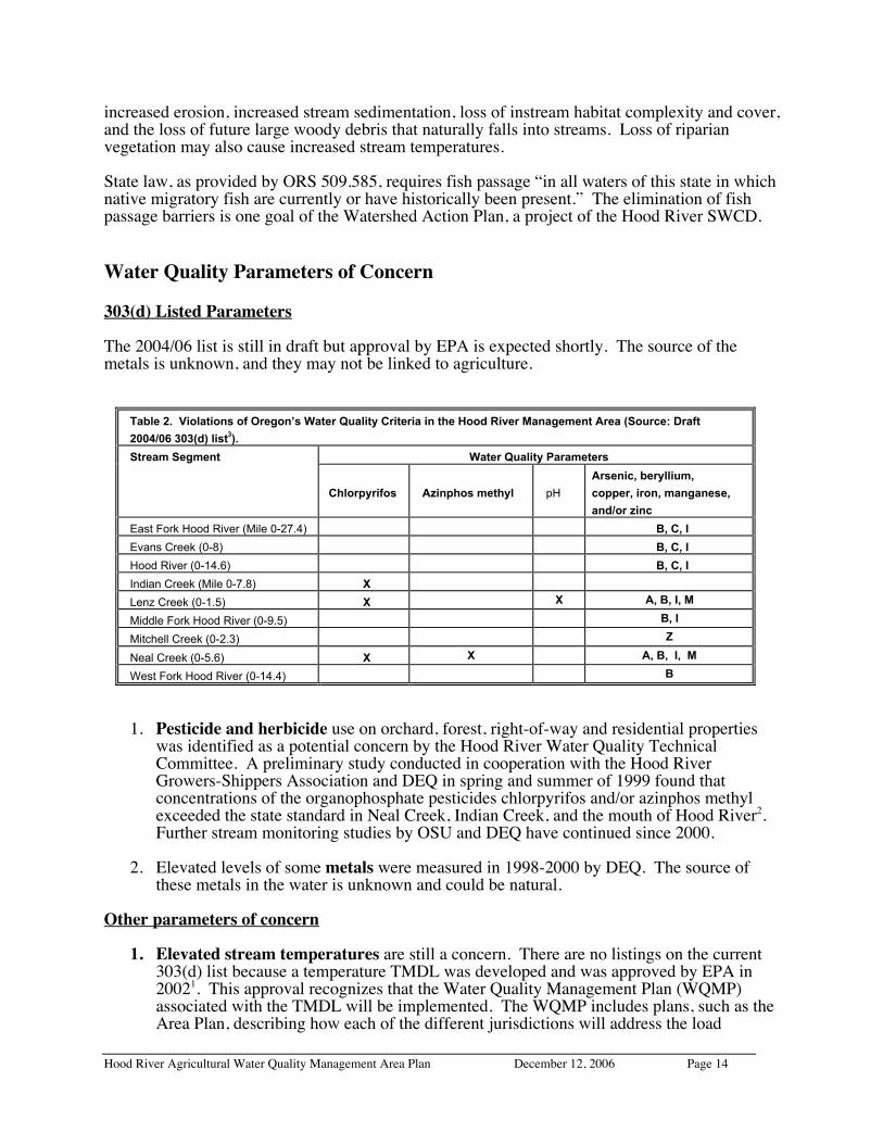
303(d) Listed Parameters
The 2004/06 list is still in draft but approval by EPA is expected shortly. The source of themetals is unknown, and they may not be linked to agriculture.
Table 2. Violations of Oregon’s Water Quality Criteria in the Hood River Management Area (Source: Draft
2004/06 303(d) list3).
Stream Segment Water Quality Parameters
Chlorpyrifos Azinphos methyl pH
Arsenic, beryllium,
copper, iron, manganese,
and/or zinc
East Fork Hood River (Mile 0-27.4) B, C, I
Evans Creek (0-8) B, C, I
Hood River (0-14.6) B, C, I
Indian Creek (Mile 0-7.8) X
Lenz Creek (0-1.5) X X A, B, I, M
Middle Fork Hood River (0-9.5) B, I
Mitchell Creek (0-2.3) Z
Neal Creek (0-5.6) X X A, B, I, M
West Fork Hood River (0-14.4) B
1. Pesticide and herbicide use on orchard, forest, right-of-way and residential propertieswas identified as a potential concern by the Hood River Water Quality TechnicalCommittee. A preliminary study conducted in cooperation with the Hood RiverGrowers-Shippers Association and DEQ in spring and summer of 1999 found thatconcentrations of the organophosphate pesticides chlorpyrifos and/or azinphos methylexceeded the state standard in Neal Creek, Indian Creek, and the mouth of Hood River2.Further stream monitoring studies by OSU and DEQ have continued since 2000.
2. Elevated levels of some metals were measured in 1998-2000 by DEQ. The source ofthese metals in the water is unknown and could be natural.
Other parameters of concern
1. Elevated stream temperatures are still a concern. There are no listings on the current303(d) list because a temperature TMDL was developed and was approved by EPA in20021. This approval recognizes that the Water Quality Management Plan (WQMP)associated with the TMDL will be implemented. The WQMP includes plans, such as theArea Plan, describing how each of the different jurisdictions will address the load
Hood River Agricultural Water Quality Management Area Plan December 12, 2006 Page 15
allocations in the TMDL. Subject to available resources, DEQ intends to review theprogress of the TMDL and WQMP on a five-year basis.
The temperature standard was revised in 2004. It assigns a temperature criterion (50˚,53.6˚, 55.4˚, 60.8˚or 64.4˚F) to each water body depending on its use by fish (species, lifestage, and time of year). If the water temperature exceeds the criterion, human activitiescannot further increase the temperature. The natural water temperature can be higherthan the criterion.
DEQ, in conjunction with fisheries agencies, has defined the salmonid spawning andrearing periods and locations in the Management Area. There are reaches throughout theManagement Area where the core spawning (55.4˚F), cold water habitat (60.8˚F), and/orrearing (64.4˚F) criteria are exceeded at certain times of the year.
The 53.6˚F bull trout temperature criterion is exceeded3 in the Middle Fork Hood Riverand Clear Branch below Laurance Lake. The old bull trout criterion (50˚F) was alsoexceeded in Clear Branch above the Lake and in Compass Creek. A preliminary datareview suggests that these streams do not exceed the new numeric criterion of 53.6˚F.
2. Elevated nitrogen and phosphorous (nutrient) concentrations exceeding recommendedcriteria were measured in 1998 in Odell, McGuire, Neal, Lenz, Trout, Wishart, Whiskey,Baldwin, and Indian Creeks, and in 2001 and 2002 in Baldwin, Graham, Rhoade(tributary to Lenz Creek), Tieman, and Odell Creeks. The Oregon WatershedAssessment Manual recommends using a value of 0.3 mg/L for nitrogen (as total nitrate)to evaluate water quality4; scientific literature reports that concentrations greater than 0.3mg/L can trigger algal blooms5. The value of 0.3 mg/L does not have any regulatorystanding, as Oregon currently does not have nitrogen standards for surface water in theManagement Area. The maximum nitrate concentration measured in 1998 was 4.0 mg/Lin McGuire Creek, and 4.84 in Rhoade Creek in 2001. Nitrogen concentrations generallyincreased in a downstream direction in response to adjacent land uses.
Oregon currently does not have phosphorus standards for the Management Area. Theexpected natural concentration of total phosphorous in forested streams is less than 0.02mg/L6. To prevent nuisance algal growth in cold-water streams that do not dischargedirectly to a lake or reservoir, EPA recommends a total phosphorous concentration of0.10 mg/L or less7. The maximum concentration measured in 1998 sampling was 1.2mg/L in Odell Creek. Phosphorous concentrations tended to increase in a downstreamdirection; for example, samples taken in the upper Neal Creek system were close toexpected natural levels.
3. Based on 1998 DEQ monitoring study results, dissolved oxygen (DO) concentrations inthe Hood River drainage2 ranged from 8.3 – 11.7 mg/L in June, 7.8 – 10.7 mg/L inAugust, and 8.0 – 11.8 mg/L in October. Because the state DO standard relies on adetermination of salmonid spawning vs. rearing periods for each stream reach, furtheranalysis and input from fisheries agencies is needed to assess where and when state DOstandards apply.
4. Bacteria are used to determine the safety for “human contact recreation." High levels ofE. coli bacteria can cause severe gastric illness and even death. In 1998, DEQ samplingshowed exceedances of the state standard at sites on Wishart, Baldwin, Odell, McGuire,Whiskey, Spring and Indian Creeks. A more comprehensive study would be needed toidentify contamination sources and the degree of the contamination problem.
Hood River Agricultural Water Quality Management Area Plan December 12, 2006 Page 16
5. Sediment: Oregon currently does not have numeric sediment standards. Only one of 34sites (Wishart Creek) sampled during the 1998 DEQ intensive study exceeded2 theturbidity guideline of 50 Nephelometric Turbidity Units (NTUs) recommended by theOregon Watershed Enhancement Board4. However, this study was conducted during thedry season when there were no rain events. Monitoring by the Hood River WatershedGroup in 1997 and 1998 has shown elevated sediments in Neal Creek. It is unknownwhat proportion of suspended sediment in the Management Area occurs naturally asglacial silt, and how much has been introduced by human activity. Some glacial silt hasbeen transferred to non-glacial streams by irrigation systems.
Potential Contributors To Water Pollution
Potential contributors to pollution in the Management Area include runoff and erosion fromagricultural and forest lands, eroding streambanks, runoff from roads and urban areas, wastedischarges from pipes, municipal and domestic withdrawals, sewage treatment plants, urbanstormwater, hydroelectric diversions on the Hood River, failing septic systems, and landslides.Rerouting of runoff via road building, construction, and land surfacing such as parking areas maylead to excessive erosion or pollutant transport. Pollutants may be carried to the surface water orgroundwater through the actions of rainfall, snowmelt, irrigation, and leaching. Increased heatinput due to vegetation removal, seasonal flow reduction, changes in channel shape, andfloodplain alteration is a source of water quality impairment. Channelization and bank instabilitymay alter gradient, width/depth ratio, and sinuosity, thereby causing undesirable changes insediment transport regime, erosional and depositional characteristics, and temperature. Sedimentinput into streams due to human activity is primarily related to roads, undersized culverts at roadcrossings, and irrigation ditches2.
Land conditions associated with the following agricultural activities were identified by the LACas potential contributors to water quality concerns:
• Removal or reduction of vegetation along streams• Livestock grazing and areas of concentrated livestock• Irrigation water use and drainage• Application and storage of crop nutrients and farm chemicals• Agricultural roads

Hood River Agricultural Water Quality Management Area Plan December 12, 2006 Page 17
3: MISSION, GOALS, AND OBJECTIVES
Mission
Develop a Hood River Agricultural Water Quality Management Area Plan that willguide the prevention and control of water pollution and soil erosion
to help achieve water quality standards that protect beneficial uses (OAR 603-090)
Goal
Promote agricultural management that will improve and protect water qualitywhile sustaining a healthy agricultural economy
Objectives
1. Minimize agriculture’s contribution to the following water quality concerns:• temperature: maintain adequate vegetation along streams and sufficient instream flows;
enhance natural channel morphology• nutrients: keep nutrients on site and out of streams by applying nutrients at appropriate
rates and times; minimize amount of nutrient-laden runoff; maintain adequate streamsidevegetation
• pesticides: keep pesticides on site and out of streams by applying, handling, and storingpesticides appropriately; minimize runoff and aerial drift; maintain adequate streamsidevegetation
• bacteria: keep livestock waste on the land and out of streams by managing pastures,watering sites, and holding facilities to control runoff; maintain adequate streamsidevegetation
• sediment: keep soil on the land and out of streams by minimizing soil erosion andamount of soil-laden runoff; maintain adequate vegetation along streams
• petroleum products: avoid spills and clean up spills appropriately; store properly
2. The LAC, Hood River SWCD, and ODA will:• develop and implement strategies to provide landowners with information and technical
and financial assistance• work with others to develop and participate in a long-term monitoring plan that will:
- characterize baseline conditions- track Area Plan implementation- evaluate Area Plan effectiveness, including improvements in water quality and land
conditions- identify priority areas- identify annual and long-range strategies for Area Plan implementation
• continue to include the public in the development and implementation of the Area Planand Rules process
The LAC expects that recommended and required actions will be cost-effective and that fundingwill be available from private and public sources to assist landowners with implementingprojects.
Hood River Agricultural Water Quality Management Area Plan December 12, 2006 Page 18
4: MANAGEMENT MEASURESWater pollution will be minimized through a combination of landowner education andimplementation of appropriate Management Measures. Management Measures include bothRecommended Management Practices and the Area Rules.
This section outlines the intent of those Measures, lists some voluntary RecommendedManagement Practices and presents the Area Rules. These Management Measures will addressthe objectives of the Area Plan.
A. Management Intent
To help achieve water quality standards in the Management Area, an effective strategy must:1. maintain adequate vegetation along streams2. minimize streambank erosion3. minimize potential pollutants in streams4. maximize irrigation efficiency
Voluntary efforts will be the primary means to prevent and control agricultural sources ofpollution. Local, state, and federal agencies and organizations will provide information andtechnical and financial assistance. The Hood River SWCD and Extension will be the mainsupport agencies at the local level.
Landowners have flexibility in choosing management approaches and practices to address waterquality issues on their lands. Landowners may choose to develop management systems toaddress problems on their own, or they may choose to develop a Voluntary Conservation Plan toaddress applicable resource issues. Landowners may seek planning assistance from any agencyor a consultant.
Regulatory measures (Area Rules) are included in addition to voluntary strategies. ODA willpursue enforcement to gain compliance with the Area Rules only when reasonable attempts at avoluntary solution have failed. (See Area Rules in Section C.)
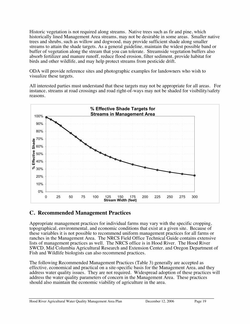
B. TDML Shade Targets1
The TMDL developed by DEQ addresses high stream temperatures. The goal of the TMDL is toreduce the amount of solar radiation that reaches the waterway. The amount of “load” of solarradiation is measured by DEQ in langleys per day. For the non-scientist, these loads have beentranslated into Percent Effective Shade targets.
The TMDL contains Percent Effective Shade Targets for the Management Area. Landownersmay use these targets as a guide to determine if they have sufficient riparian vegetation. PercentEffective Shade is the amount of shade that reaches the stream. For example, 70% EffectiveShade means that shade has kept 70% of the sunshine on an August day from reaching thestream.
The following graph approximates these shade targets. For example, shade should interceptapproximately 99% of the sunlight reaching a 5-foot wide stream on an August day, and 89% ofthe sunlight reaching a 30-foot wide stream on an August day.
Hood River Agricultural Water Quality Management Area Plan December 12, 2006 Page 19
Historic vegetation is not required along streams. Native trees such as fir and pine, whichhistorically lined Management Area streams, may not be desirable in some areas. Smaller nativetrees and shrubs, such as willow and dogwood, may provide sufficient shade along smallerstreams to attain the shade targets. As a general guideline, maintain the widest possible band orbuffer of vegetation along the stream that you can tolerate. Streamside vegetation buffers alsoabsorb fertilizer and manure runoff, reduce flood erosion, filter sediment, provide habitat forbirds and other wildlife, and may help protect streams from pesticide drift.
ODA will provide reference sites and photographic examples for landowners who wish tovisualize these targets.
All interested parties must understand that these targets may not be appropriate for all areas. Forinstance, streams at road crossings and road right-of-ways may not be shaded for visibility/safetyreasons.
C. Recommended Management Practices
Appropriate management practices for individual farms may vary with the specific cropping,topographical, environmental, and economic conditions that exist at a given site. Because ofthese variables it is not possible to recommend uniform management practices for all farms orranches in the Management Area. The NRCS Field Office Technical Guide contains extensivelists of management practices as well. The NRCS office is in Hood River. The Hood RiverSWCD, Mid Columbia Agricultural Research and Extension Center, and Oregon Department ofFish and Wildlife biologists can also recommend practices.
The following Recommended Management Practices (Table 3) generally are accepted aseffective, economical and practical on a site-specific basis for the Management Area, and theyaddress water quality issues. They are not required. Widespread adoption of these practices willaddress the water quality parameters of concern in the Management Area. These practicesshould also maintain the economic viability of agriculture in the area.
% Effective Shade Targets for Streams in Management Area
0%
10%
20%
30%
40%
50%
60%
70%
80%
90%
100%
0 25 50 75 100 125 150 175 200 225 250 275 300Stream Width (feet)
% E
ffec
tive
Sh
ade
Hood River Agricultural Water Quality Management Area Plan December 12, 2006 Page 20
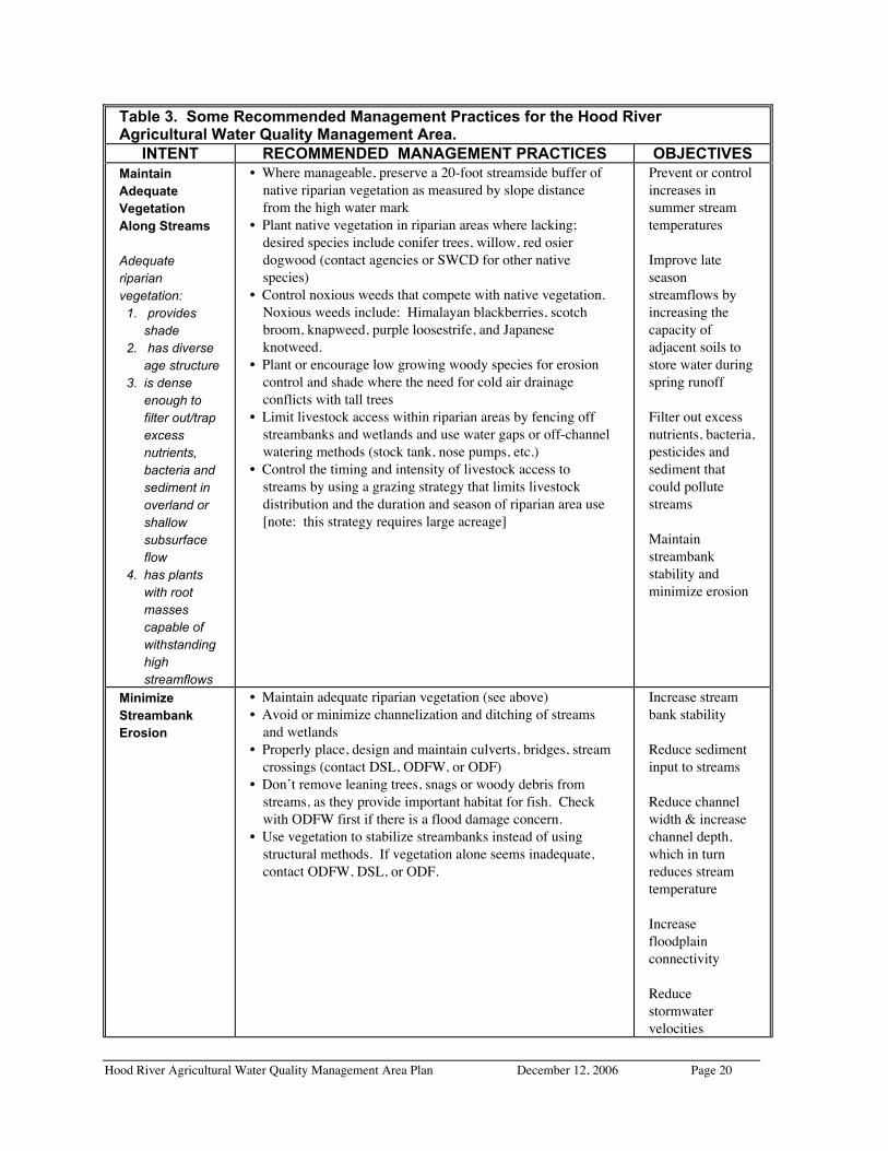
Table 3. Some Recommended Management Practices for the Hood RiverAgricultural Water Quality Management Area.
INTENT RECOMMENDED MANAGEMENT PRACTICES OBJECTIVESMaintainAdequateVegetationAlong Streams
Adequateriparianvegetation: 1. provides
shade 2. has diverse
age structure 3. is dense
enough tofilter out/trapexcessnutrients,bacteria andsediment inoverland orshallowsubsurfaceflow
4. has plantswith rootmassescapable ofwithstandinghighstreamflows
• Where manageable, preserve a 20-foot streamside buffer ofnative riparian vegetation as measured by slope distancefrom the high water mark
• Plant native vegetation in riparian areas where lacking;desired species include conifer trees, willow, red osierdogwood (contact agencies or SWCD for other nativespecies)
• Control noxious weeds that compete with native vegetation.Noxious weeds include: Himalayan blackberries, scotchbroom, knapweed, purple loosestrife, and Japaneseknotweed.
• Plant or encourage low growing woody species for erosioncontrol and shade where the need for cold air drainageconflicts with tall trees
• Limit livestock access within riparian areas by fencing offstreambanks and wetlands and use water gaps or off-channelwatering methods (stock tank, nose pumps, etc.)
• Control the timing and intensity of livestock access tostreams by using a grazing strategy that limits livestockdistribution and the duration and season of riparian area use[note: this strategy requires large acreage]
Prevent or controlincreases insummer streamtemperatures
Improve lateseasonstreamflows byincreasing thecapacity ofadjacent soils tostore water duringspring runoff
Filter out excessnutrients, bacteria,pesticides andsediment thatcould pollutestreams
Maintainstreambankstability andminimize erosion
MinimizeStreambankErosion
• Maintain adequate riparian vegetation (see above)• Avoid or minimize channelization and ditching of streams
and wetlands• Properly place, design and maintain culverts, bridges, stream
crossings (contact DSL, ODFW, or ODF)• Don’t remove leaning trees, snags or woody debris from
streams, as they provide important habitat for fish. Checkwith ODFW first if there is a flood damage concern.
• Use vegetation to stabilize streambanks instead of usingstructural methods. If vegetation alone seems inadequate,contact ODFW, DSL, or ODF.
Increase streambank stability
Reduce sedimentinput to streams
Reduce channelwidth & increasechannel depth,which in turnreduces streamtemperature
Increasefloodplainconnectivity
Reducestormwatervelocities
Hood River Agricultural Water Quality Management Area Plan December 12, 2006 Page 21
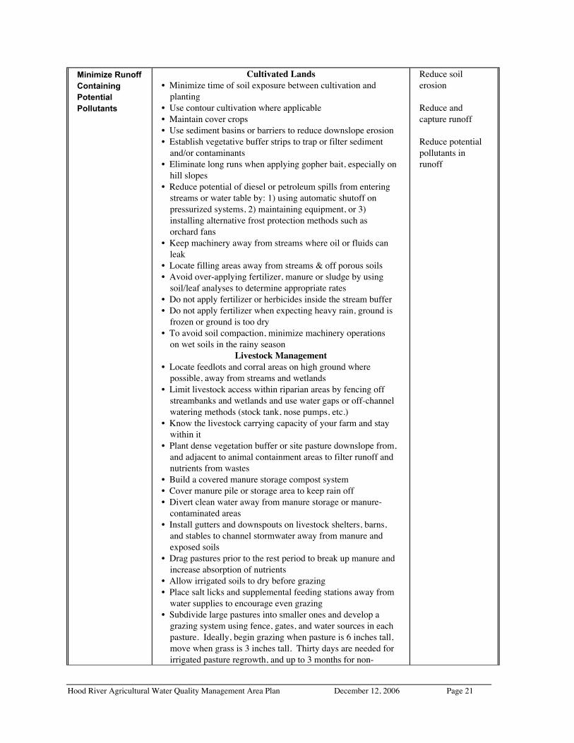
Minimize RunoffContainingPotentialPollutants
Cultivated Lands• Minimize time of soil exposure between cultivation and
planting• Use contour cultivation where applicable• Maintain cover crops• Use sediment basins or barriers to reduce downslope erosion• Establish vegetative buffer strips to trap or filter sediment
and/or contaminants• Eliminate long runs when applying gopher bait, especially on
hill slopes• Reduce potential of diesel or petroleum spills from entering
streams or water table by: 1) using automatic shutoff onpressurized systems, 2) maintaining equipment, or 3)installing alternative frost protection methods such asorchard fans
• Keep machinery away from streams where oil or fluids canleak
• Locate filling areas away from streams & off porous soils• Avoid over-applying fertilizer, manure or sludge by using
soil/leaf analyses to determine appropriate rates• Do not apply fertilizer or herbicides inside the stream buffer• Do not apply fertilizer when expecting heavy rain, ground is
frozen or ground is too dry• To avoid soil compaction, minimize machinery operations
on wet soils in the rainy seasonLivestock Management
• Locate feedlots and corral areas on high ground wherepossible, away from streams and wetlands
• Limit livestock access within riparian areas by fencing offstreambanks and wetlands and use water gaps or off-channelwatering methods (stock tank, nose pumps, etc.)
• Know the livestock carrying capacity of your farm and staywithin it
• Plant dense vegetation buffer or site pasture downslope from,and adjacent to animal containment areas to filter runoff andnutrients from wastes
• Build a covered manure storage compost system• Cover manure pile or storage area to keep rain off• Divert clean water away from manure storage or manure-
contaminated areas• Install gutters and downspouts on livestock shelters, barns,
and stables to channel stormwater away from manure andexposed soils
• Drag pastures prior to the rest period to break up manure andincrease absorption of nutrients
• Allow irrigated soils to dry before grazing• Place salt licks and supplemental feeding stations away from
water supplies to encourage even grazing• Subdivide large pastures into smaller ones and develop a
grazing system using fence, gates, and water sources in eachpasture. Ideally, begin grazing when pasture is 6 inches tall,move when grass is 3 inches tall. Thirty days are needed forirrigated pasture regrowth, and up to 3 months for non-irrigated pasture.
Reduce soilerosion
Reduce andcapture runoff
Reduce potentialpollutants inrunoff

Hood River Agricultural Water Quality Management Area Plan December 12, 2006 Page 22
irrigated pasture.• Use pasture rotation and good grazing management to
produce more feed, fewer weeds and a minimum of bareground
• During winter, corral animals and feed hay to avoidcompacting saturated soils unless well drained and pasture isactively growing
• Allow long rest periods or use a high intensity, short-duration grazing to rejuvenate a pasture in poor condition
MinimizePesticidesin Streams
• Always follow the container label, apply properly and avoidover-application
• Rinse and dispose of pesticide containers properly• Use Integrated Fruit Production (IFP) orchard management
or Integrated Pest Management (IPM) practices, e.g., insectpheromone disrupters to reduce the need for pesticides,beneficial insect populations, alternative “softer” pesticides(contact Extension Agent or Experiment Station)
• Monitor pest populations to document need, location andtiming of sprays
• Voluntarily reduce application amounts or number of sprays• Maintain/service spray equipment to avoid leaks and
improper calibration• Build and maintain proper mixing facilities on less
permeable soils away from wells and waterways• Provide training for field employees in proper pesticide use
and handling• Build and maintain safe chemical storage that is: away from
creeks and ditches, covered, elevated, contained, and secured• Establish and maintain vegetative buffers to reduce runoff
and protect streams from accidental drift and directapplication
• Where small, non-fish bearing creeks cross through orchard,pipe creek only if buffer strip or other alternative is notfeasible. On-site consultation with NRCS is recommendedto avoid noncompliance with State and Federal wetlandconservation rules.
• Do not fill tanks directly from creeks or waterways ifpossible – use back flow devices if you do
• Use buffers, dense ground cover and efficient irrigationmanagement to increase water infiltration and to prevent soilrunoff
• Apply spray tank rinse water back onto orchard – do notdrain out onto ground in one spot
• Apply aquatic herbicides correctly and sparingly, in strictaccordance with label
• Eliminate air drift in ground and aerial application: 1) avoidspraying in wind, 2) use tower sprayer or other directedapplicator, 3) use spray additives to reduce drift, 4) practiceone- direction spraying: spray only the outside of the outertwo rows, spray inward at a lower speed for good coverage,and 5) turn nozzles off at end of each row
• Spills: prepare a spill response plan; mix and load sprayersin areas where runoff to streams and ditches cannot occur;and use anti-foaming additives
Eliminate air driftof pesticides
Reduce runoff andpesticides inrunoff
Minimizeleaching togroundwater
Minimize chancesfor spills to enterstreams
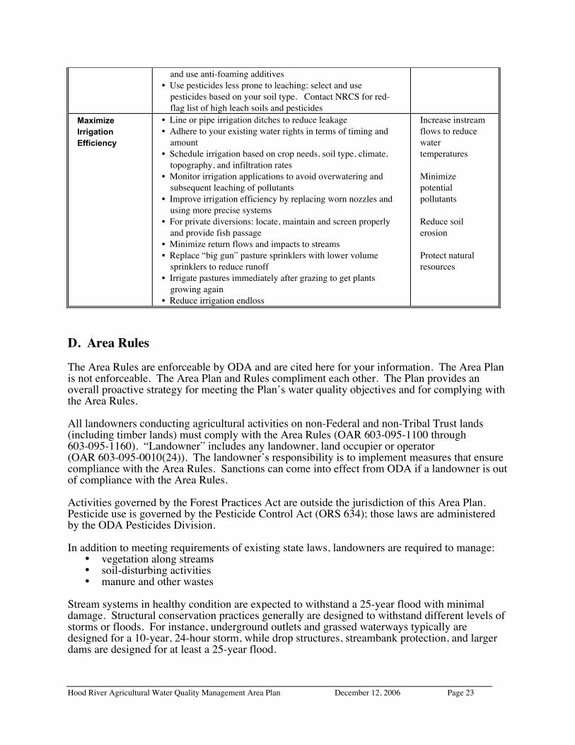
Hood River Agricultural Water Quality Management Area Plan December 12, 2006 Page 23
and use anti-foaming additives• Use pesticides less prone to leaching; select and use
pesticides based on your soil type. Contact NRCS for red-flag list of high leach soils and pesticides
MaximizeIrrigationEfficiency
• Line or pipe irrigation ditches to reduce leakage• Adhere to your existing water rights in terms of timing and
amount• Schedule irrigation based on crop needs, soil type, climate,
topography, and infiltration rates• Monitor irrigation applications to avoid overwatering and
subsequent leaching of pollutants• Improve irrigation efficiency by replacing worn nozzles and
using more precise systems• For private diversions: locate, maintain and screen properly
and provide fish passage• Minimize return flows and impacts to streams• Replace “big gun” pasture sprinklers with lower volume
sprinklers to reduce runoff• Irrigate pastures immediately after grazing to get plants
growing again• Reduce irrigation endloss
Increase instreamflows to reducewatertemperatures
Minimizepotentialpollutants
Reduce soilerosion
Protect naturalresources
D. Area Rules
The Area Rules are enforceable by ODA and are cited here for your information. The Area Planis not enforceable. The Area Plan and Rules compliment each other. The Plan provides anoverall proactive strategy for meeting the Plan’s water quality objectives and for complying withthe Area Rules.
All landowners conducting agricultural activities on non-Federal and non-Tribal Trust lands(including timber lands) must comply with the Area Rules (OAR 603-095-1100 through603-095-1160). “Landowner” includes any landowner, land occupier or operator(OAR 603-095-0010(24)). The landowner’s responsibility is to implement measures that ensurecompliance with the Area Rules. Sanctions can come into effect from ODA if a landowner is outof compliance with the Area Rules.
Activities governed by the Forest Practices Act are outside the jurisdiction of this Area Plan.Pesticide use is governed by the Pesticide Control Act (ORS 634); those laws are administeredby the ODA Pesticides Division.
In addition to meeting requirements of existing state laws, landowners are required to manage:• vegetation along streams• soil-disturbing activities• manure and other wastes
Stream systems in healthy condition are expected to withstand a 25-year flood with minimaldamage. Structural conservation practices generally are designed to withstand different levels ofstorms or floods. For instance, underground outlets and grassed waterways typically aredesigned for a 10-year, 24-hour storm, while drop structures, streambank protection, and largerdams are designed for at least a 25-year flood.

Hood River Agricultural Water Quality Management Area Plan December 12, 2006 Page 24
Area Rules may become more specific over time, as information becomes available on landconditions and water quality.
Oregon Administrative Rules 603-095-1140
Requirements(1) Landowners must comply with OAR 603-95-1140(2) through (3) within the
following limitations:(a) A landowner is responsible for only those conditions resulting from activities
controlled by the landowner. A landowner is not responsible for conditionsresulting from activities by landowners on other lands. A landowner is notresponsible for conditions that: are natural, could not have been reasonablyanticipated, or that result from unusual weather events or other exceptionalcircumstances.
(2) Streamside Vegetation(a) Effective upon adoption of these rules, agricultural activities must allow the
establishment, growth, and maintenance of vegetation along streams. Vegetationmust be sufficient to control water pollution by moderating solar heating,minimizing streambank erosion, filtering sediments and nutrients from overlandflows, and improving the infiltration of water into the soil profile. Thestreambank should have sufficient vegetation to resist erosion during highstreamflows, such as those reasonably expected to occur once every 25 years.
(3) Waste Management(a) Effective on rule adoption, no person subject to these rules shall violate any
provision of ORS 468B.025 or ORS 468B.050.
"Streams" in Rule (2) refers to natural waterways such as streams, creeks, and rivers that werecreated through natural processes. They may have been altered by human activities, such aschannelized creeks, but not created by human activities, such as irrigation ditches.
ODA will determine when streambank vegetation is sufficient to control water pollution. TheTotal Maximum Daily Load (TMDL) developed by DEQ1 will help guide this determination.
The Waste Management Rule currently is State Law (ORS 468B). ORS 468B.025 states that noperson shall:(1) (a) Cause pollution of any waters of the state or place or cause to be placed any wastes in a
location where such wastes are likely to escape or be carried into the waters of the stateby any means.
(b) Discharge any wastes into the waters of the state if the discharge reduces the quality ofsuch waters below the water quality standards established by rule for such waters by theEnvironmental Quality Commission.
(2) (a) Violate the conditions of any waste discharge permit issued under ORS 468B orORS 568.
ORS 468B.050 refers to situations when permits are required, such as for certain confined animalfeeding operations.
Hood River Agricultural Water Quality Management Area Plan December 12, 2006 Page 25
Definitions:
Wastes include manure, commercial fertilizers, soil amendments, composts, vegetative materials,or any other substances that will or may cause water pollution (OAR 603-095-0010(53)).Therefore, ‘wastes’ also include sediment.
Waste discharge means the discharge of waste, either directly or indirectly, into waters of thestate (OAR 603-095-0010(54)).
Water pollution means such alteration of the physical, chemical or biological properties of anywaters of the state, including change in temperature, taste, color, turbidity, silt or odor of thewaters, or such discharge of any liquid, gaseous, solid, radioactive or other substance into anywaters of the state, which will or tends to, either by itself or in connection with any othersubstance, create a public nuisance or which will or tends to render such waters harmful,detrimental or injurious to public health, safety or welfare, or to domestic, commercial,industrial, agricultural, recreational or other legitimate beneficial uses or to livestock, wildlife,fish or other aquatic life or the habitat thereof (ORS 468B.005(7)).
Waters of the State include lakes, bays, ponds, impounding reservoirs, springs, wells, rivers,streams, creeks, marshes, inlets, canals, and all other bodies of surface or underground waters,natural or artificial, public or private (except those private waters which do not connect to naturalsurface or underground waters) within Oregon (from ORS 468B.005(8)).
Hood River Agricultural Water Quality Management Area Plan December 12, 2006 Page 26
5: STRATEGIES TO ACHIEVE GOALS & OBJECTIVES
Voluntary Approach
To the greatest degree possible, prevention and control of agricultural pollution will beencouraged in a cooperative spirit through the voluntary efforts of landowners, aided byinformation and technical and financial assistance from local, state, and federal agencies, andothers.
Education is the key to the success of this Area Plan. The Hood River SWCD, NRCS, MidColumbia Agricultural Research and Extension Center, and Hood River Growers-ShippersAssociation will work together to provide agricultural landowners in the Management Area withinformation about the goals, objectives, and requirements of the Area Rules.
The following strategies will be employed at the local level by the Hood River SWCD incooperation with landowners, other agencies and organizations.
1. Work to improve the quality of water in the Management Area through planning andimplementation of technically sound and economically feasible conservation practicesthat contribute to meeting Area Plan objectives.
a. Limit pollution caused by agricultural activities by implementing successfulpractices for streambank stabilization, reduction of extreme water temperatures,and restoration and enhancement of wetlands and riparian areas, while avoidingadverse fish habitat modification.
b. Implement conservation practices to improve irrigation water use and conveyanceefficiency to reduce the impact of seasonal flow modifications on streamsresulting from water withdrawals.
c. Show progress in reduction of pollution from agricultural and rural lands throughperiodic surveys of stream reaches and associated lands.
2. Create a high level of awareness and an understanding of water quality issues among theagricultural community and rural public, in a manner that minimizes conflict andencourages cooperative efforts, through education and technical assistance.
a. Incorporate Area Plan implementation as a priority element in the Hood RiverSWCD’s Annual Work Plan and Long Range Plan, with support from partnerorganizations.
b. Promote cooperative on-the-ground projects in cooperation with partnerorganizations to solve critical problems identified by landowners and landmanagers.
c. Showcase successful practices and systems and conduct annual tours forlandowners and media.
d. Recognize successful projects and practices through appropriate media andnewsletters.
e. Conduct educational programs to promote public awareness of water qualityissues and their solutions.

Hood River Agricultural Water Quality Management Area Plan December 12, 2006 Page 27
f. Proactively offer and provide site evaluations on any lands within theManagement Area to assess conditions that may affect water quality.
g. Prioritize subwatersheds within the Management Area for targetingimplementation strategies.
3. Encourage adequate funding and administration of the program to achieve Area Plangoals and objectives by systematic, long-range planning and focusing of coordinatedefforts on full scale, watershed-based approaches; identifying needs; developing projects;actively seeking funding; and ensuring successful implementation of funded projects.
For example, grants are being pursued to research more efficient sprayer technology, andto continue monitoring and education. In 2002, the Hood River Grower ShipperAssociation began a 2-year education project to promote pesticide best managementpractices among growers, using a grant from EPA/American Farmland Trust.
Regulatory Measures
In addition to the voluntary strategies, Area Rules (OAR 603-095-1100 through 603-095-1160)are included as an implementation strategy. ODA will use enforcement where appropriate andnecessary to gain compliance with the Area Rules. Any enforcement action will be pursued onlywhen reasonable attempts at a voluntary solution have failed. The following Area Rules providefor resolution of complaints.
Complaints and Investigations (OAR 603-095-1160)
(1) When the department (ODA) receives notice of an apparent occurrence ofagricultural pollution through a written complaint, its own observation, throughnotification by another agency, or by other means, the department may conduct aninvestigation. The department may, at its discretion, coordinate inspection activitieswith the appropriate Local Management Agency.
(2) Each notice of an alleged occurrence of agricultural pollution will be evaluated inaccordance with the criteria in ORS 568.900 to 568.933 or any rules adoptedthereunder to determine whether an investigation is warranted.
(3) Any person allegedly being damaged or otherwise adversely affected by agriculturalpollution or alleging any violation of ORS 568.900 to 568.933 or any rules adoptedthereunder may file a complaint with the department.
(4) The department will evaluate or investigate a complaint filed by a person undersection OAR 603-095-1160(3) if the complaint is in writing, signed and dated by thecomplainant and indicates the location and description of:(a) The waters of the state allegedly being damaged or impacted; and(b) The property allegedly being managed under conditions violating criteria
described in ORS 568.900 to 568.933 or any rules adopted thereunder.(5) As used in section OAR 603-095-1160(4), “person” does not include any local, state
or federal agency.(6) Notwithstanding OAR 603-095-1160, the department may investigate at any time
any complaint if the department determines that the violation alleged in thecomplaint may present an immediate threat to the public health or safety.
(7) If the department determines that a violation of ORS 568.900 to 568.933 or any rulesadopted thereunder has occurred, the landowner may be subject to the enforcementprocedures of the department outlined in OARs 603-090-0060 through 603-090-0120.

Hood River Agricultural Water Quality Management Area Plan December 12, 2006 Page 28
6: MONITORING AND EVALUATIONA monitoring plan will be implemented to:
1. Characterize existing water quality and land conditions2. Track Area Plan implementation and compliance with the Area Rules3. Evaluate Area Plan progress in improving water quality and land conditions
Representatives of the Confederated Tribes of the Warm Springs Reservation, Hood RiverGrowers-Shippers Association, Hood River Watershed Group, PacifiCorp, irrigation districts,DEQ, and other state and federal agencies currently monitor various water quality parameters inthe Management Area. ODA is responsible for monitoring land conditions that influence waterquality in agricultural areas. The LAC, ODA, and the Hood River SWCD will evaluate theeffectiveness of the Area Plan in improving water quality and land conditions.
Parameters likely to be monitored by local partners include stream temperature, bacteria,turbidity, pesticides and nutrients. ODA is monitoring riparian conditions by assessingstreamside vegetation from aerial photographs every 5 years. The first flight was in 2004. ODAcompiles the data and provides it to the LAC for review.
The Oregon Plan for Salmon and Watersheds’ Water Quality Monitoring Technical Guide Book(July 1999) is the preferred reference manual for monitoring; however, other water qualitymonitoring protocols also are available.
Area Plan Implementation
The Hood River SWCD and ODA are responsible for determining progress towards Area Plangoals. The Hood River SWCD, as the Local Management Agency, will maintain aMemorandum of Agreement with ODA that outlines their responsibilities for providing andtracking educational outreach and technical assistance.
The Hood River SWCD will:• identify potential sources of nutrients, pesticides, temperature increases, and other
contributors to non-attainment of all applicable water quality standards• participate in developing and evaluating outreach and education programs designed to
increase public awareness and understanding of water quality issues• conduct projects, demonstrations, and tours to promote successful management practices
and systems• compile water quality and land condition data and provide a report to the LAC• evaluate the adequacy of technical and financial assistance sources available to the
agricultural community to implement recommended management practices, monitoringand education.
Area Plan Progress
The Hood River SWCD and ODA are responsible for determining whether Area Plan goal andobjectives are being met. Progress and success of implementation efforts will be assessedthrough compliance with the Area Rules and State standards and the measurement of waterquality improvement over time.

Hood River Agricultural Water Quality Management Area Plan December 12, 2006 Page 29
7: ROLES AND RESPONSIBILITIES
Area Plan Development
ODA is the Designated Management Agency for controlling pollution from agricultural activitieson agricultural, rural, and forestry lands in the Management Area. ODA is authorized to developand carry out a water quality management plan for any agricultural or rural lands, where a waterquality management plan is required by state or federal law.
The Hood River SWCD is the Local Management Agency for development of the Area PlanThey assist with meeting administration, outreach, and providing technical assistance tolandowners.
The Director of ODA appointed the Hood River Local Advisory Committee (LAC) representinglocal agricultural producers, local landowners, the Indian tribes, local agencies, and the HoodRiver SWCD to assist with the development of this Area Plan and Rules. The LAC willreconvene biennially to review the Area Plan and Rules and amend them as necessary.
The public is encouraged to participate in the Area Plan development process. All LACmeetings are open to the public, announced in the Hood River News, and follow Oregon’s PublicMeeting Laws. ODA will hold a public comment period to review draft Oregon AdministrativeRules associated with this Area Plan; the comment period will include a public hearing in theHood River area. Future amendments to the Rules will also have public comment periods.
Area Plan Implementation
The day-to-day implementation of this plan will be accomplished through Memoranda ofAgreement between the Hood River SWCD and ODA. Under such agreements, the Hood RiverSWCD will act as the Local Management Agency.
As resources allow, Hood River SWCD, Natural Resources Conservation Service, licensedpesticide applicators, and Mid-Columbia Agricultural Research and Extension Center staff areavailable to assist landowners in evaluating effective practices for reducing soil erosion andrunoff. Personnel in these offices can also design and assist with implementation of practices,and assist in identifying any sources of cost-sharing funds for the construction and/or use ofsome of these practices. Implementation priorities will be established on a periodic basisthrough annual work plans developed jointly by the Hood River SWCD and ODA with inputfrom partner agencies.
ODA and the Hood River SWCD will provide presentations to interested groups on an ongoingbasis. They also will meet individually with landowners to explain the Area Plan and Rules andto provide site-specific educational reviews of land conditions relative to water quality.
Any actions related to determination of noncompliance with the Area Rules or enforcement willbe taken up directly by ODA, as outlined in OARs 603-090.
Water quality monitoring will be coordinated by representatives of the LAC, ODA, Hood RiverSWCD, Hood River Growers-Shippers Association, Hood River Watershed Group, MidColumbia Agricultural Research and Extension Center, DEQ, and other state and federalagencies. Monitoring of land conditions is the responsibility of ODA. Area Plan success will beevaluated by the LAC, ODA, and the Hood River SWCD.
Hood River Agricultural Water Quality Management Area Plan December 12, 2006 Page 30
8: DISCUSSION OF COSTS AND FUNDINGCosts of implementing this Area Plan are difficult to assess in the absence of detailed, site-specific inventories of resource problems and quantification of nutrient and sediment loadingsand other water quality issues of concern.
To implement this Area Plan, the Hood River SWCD will need support and resources for staff toconduct the following:
• Educational programs (production and presentation)• Identification of high priority areas for implementation• Ongoing evaluation of Area Plan progress toward achieving water quality goals• Coordinated planning and implementation activities with other agencies, organizations,
and individuals working on similar goals• Watershed assessments• Water quality monitoring• Meeting management and facilitation
Technical and cost-sharing assistance for installation of certain management practices may beavailable through current USDA conservation programs such as Environmental Quality IncentiveProgram (EQIP) and Continuous Conservation Reserve Program (CRP), the EnvironmentalProtection Agency’s nonpoint source implementation grants, or state programs such as OregonWatershed Enhancement Board (OWEB) and Conservation Reserve Enhancement Program(CREP). Other agencies may also be available to provide technical assistance or financialassistance to private landowners.
CITED SOURCES1 Oregon Department of Environmental Quality. Western Hood Subbasin Total Maximum Daily
Load (TMDL). December 2001. This document can be viewed at:http://www.deq.state.or.us/wq/tmdls/Hood/HoodTMDLFinal.pdf
2 Hood River Watershed Group and H.Coccoli. Hood River Watershed Assessment Report.Hood River, OR. 1999.
3 Oregon’s DRAFT 2004/06 Section 303(d) List of Water Quality Limited Waterbodies. OregonDepartment of Environmental Quality. 2006.
4 Watershed Professionals Network. Oregon Watershed Assessment Manual. Prepared for theGovernor’s Watershed Enhancement Board, Salem, OR. 1999.
5 Cline, C. The effects of forest fertilization on the Tahuya River, Kitsap Peninsula,Washington. Washington State Department of Ecology. 1973.
6 MacDonald, L.H., A.W. Smart, and R.C. Wissmar. Monitoring Guidelines to Evaluate Effectsof Forestry Activities on Streams in the Pacific Northwest and Alaska. EPA 910/9-91-001.1991.
7 United States Environmental Protection Agency. Quality Criteria for Water.EPA 440/5-86-001. Washington, DC. 1986.