home | mograt island - 2018 der heft 29 antike sudan · 2019-03-26 · hamad mohamed hamdeen &...
TRANSCRIPT
Antike SudanDer
Mitteilungen der Sudanarchäologischen Gesellschaft zu Berlin e.V.
Hef
t 29
• 2
018
Heft29•2018
Cover picture: The head of the statue AN1936.325: Frontal view; (© Ashmolean Museum, University of Oxford).
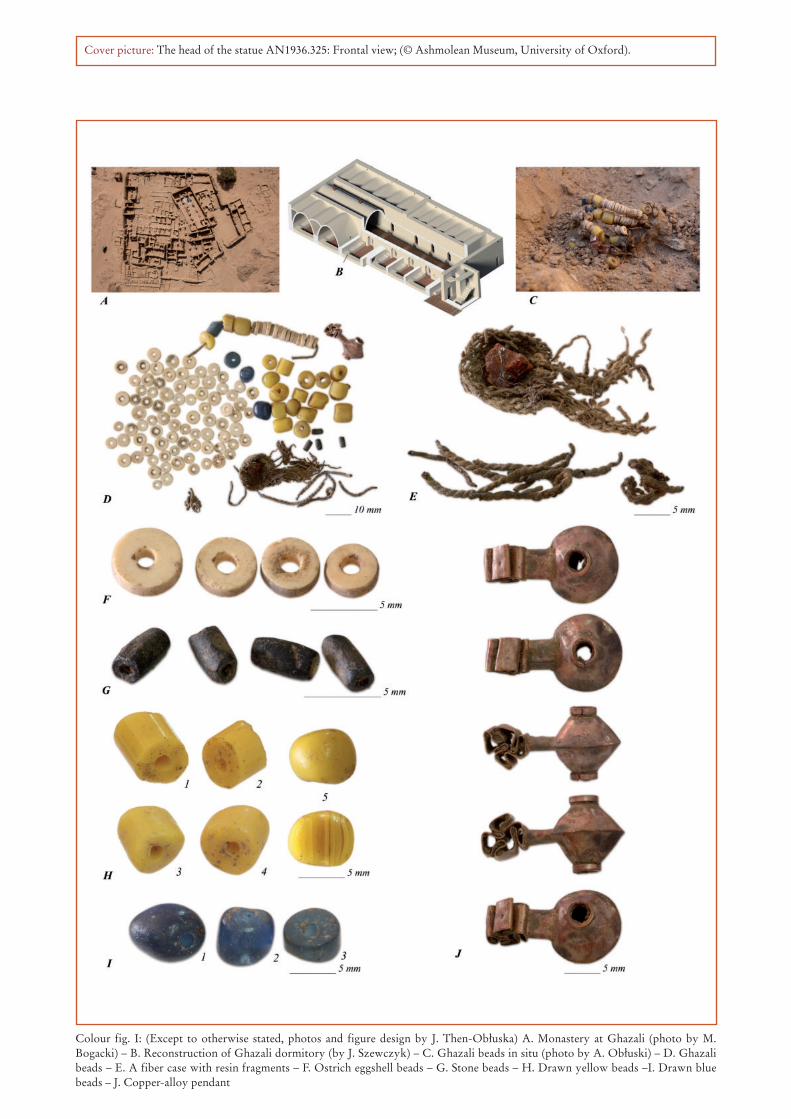
Colour fig. I: (Except to otherwise stated, photos and figure design by J. Then-Obłuska) A. Monastery at Ghazali (photo by M. Bogacki) – B. Reconstruction of Ghazali dormitory (by J. Szewczyk) – C. Ghazali beads in situ (photo by A. Obłuski) – D. Ghazali beads – E. A fiber case with resin fragments – F. Ostrich eggshell beads – G. Stone beads – H. Drawn yellow beads –I. Drawn blue beads – J. Copper-alloy pendant
Mitteilungen derSudanarchäologischen
Gesellschaft zu Berlin e.V.
Heft 292018

Impressum MittSAG 29
ISSN 0945-9502
Der antike Sudan. Mitteilungen der Sudanarchäologischen Gesellschaft zu Berlin e.V.
Kurzcode: MittSAG
Heft 29 | 2018
Herausgeber: Sudanarchäologische Gesellschaft zu Berlin e.V. c/o Humboldt-Universität zu Berlin Institut für Archäologie Archäologie und Kulturgeschichte Nordostafrikas Unter den Linden 6 | 10099 Berlin
Verantwortlich für die Herausgabe: Angelika Lohwasser Wissenschaftlicher Beirat: Julia Budka, München | David Edwards, Leicester Jochen Hallof, Würzburg | Friederike Jesse, Köln
Layout und Satz: Frank Joachim
Erscheinungsort: Berlin
Internetpräsenz: www.sag-online.de
Bankverbindung der SAG: Deutsche Bank AG BIC DEUTDEDBBER IBAN DE36 1007 0024 0055 5508 00
Die Zeitschrift Der Antike Sudan (MittSAG) erscheint einmal im Jahr.Die in den Beiträgen geäußerten Ansichten geben nicht unbedingt die Meinung des Herausgebers wieder.Die „Richtlinien für Autoren“ finden Sie unter www.sag-online.de, wir senden sie auf Anfrage auch gerne zu.
© 2018 Sudanarchäologische Gesellschaft zu Berlin e.V.Nachdruck, auch auszugsweise, nur mit Genehmigung der Gesellschaft.
Sudanarchäologische Gesellschaft zu Berlin e.V.
Angesichts der Tatsache, daß die globalen wirtschaftlichen, ökonomischen und politischen Probleme auch zu einer Gefährdung der kulturellen Hinterlassenschaften in aller Welt führen, ist es dringend geboten, gemeinsame Anstrengungen zu unternehmen, das der gesamten Menschheit gehörende Kulturerbe für künf-tige Generationen zu bewahren. Eine wesentliche Rolle bei dieser Aufgabe kommt der Archäologie zu. Ihre vornehmste Verpflichtung muß sie in der heutigen Zeit darin sehen, bedrohte Kulturdenkmäler zu pflegen und für ihre Erhaltung zu wirken.
Die Sudanarchäologische Gesellschaft zu Berlin e.V. setzt sich besonders für den Erhalt des Ensembles von Sakralbauten aus meroitischer Zeit in Musawwarat es Sufra/Sudan ein, indem sie konservatorische Arbeiten unterstützt, archäologische Ausgrabungen fördert sowie Dokumentation und Publikation der Altertümer von Musawwarat ermöglicht. Wenn die Arbeit der Sudanarchäologischen Gesellschaft zu Berlin Ihr Interesse geweckt hat und Sie bei uns mitarbeiten möchten, werden Sie Mitglied! Wir sind aber auch für jede andere Unterstützung dankbar. Wir freuen uns über Ihr Interesse!
Mitgliedsbeiträge jährlich:Vollmitglied: € 65.- | Ermäßigt: € 35.- | Studierende: € 25.- | Fördermitglied: mind. € 250.-

2018 Inhaltsverzeichnis
Übersichtskarte .................................................................................................................................................. 4
Editorial .............................................................................................................................................................. 5
Aus der Archäologie
Ahmed Hamid Nassr & Mirosław MasojćThe EDAR Project – Archaeological Collaboration Outcomes between theUniversity of Al Neelain and the University of Wrocław in the Eastern Desert, Sudan ............................. 7
Hamad Mohamed Hamdeen & Paweł Lech PolkowskiRock art in Wadi Gorgod in the Western Third Cataract Region ................................................................ 17
Modather Abdalla JadainAn Archaeological Survey North of the 6th Cataract: GIS study of Sabaloka East .................................. 39
Svetlana E. MalykhCeramic libation basins from the Meroitic temple in Abu Erteila .............................................................. 59
Joanna Then-Obłuska & Barbara WagnerBeads for Nubian monks: An interdisciplinary assessment of a Ghazali find ............................................ 65
Petra Weschenfelder & Peter BeckerThe fortress of Maqall – community archaeology and cultural heritage onMograt Island, Sudan ..................................................................................................................................... 71
Varia
Angelika LohwasserDas Paneel der Katimala in Semna ............................................................................................................... 89
Elizabeth EltzePutting your best foot forward: Two votive offerings of feet at Temple T at Kawa .................................. 97
Alexey K. VinogradovThe Gematen “Monument of Aspelta”: A Destroyed Object Revisited ................................................... 107
Josefine KuckertzAmanakhareqerema – a Meroitic King of the 1st Century AD ................................................................ 119
Petra WeschenfelderNubian place names on Mograt Island, Sudan ........................................................................................... 145
NachrufRodolfo Fattovich (1945 – 2018) .................................................................................................................. 149
NachrufZbigniew Borcowski (1953 – 2018) .............................................................................................................. 151

Übersichtskarte MittSAG 29
4

2018 Aus der Archäologie
71
Petra Weschenfelder & Peter Becker
The fortress of Maqall – communityarchaeology and cultural heritage on
Mograt Island, Sudan
1. Introduction1
The village of Maqall is among the first larger villages one encounters on Mograt Island when entering the island by ferry (fig. 1); the village part Hajer Maqall marks the high-est district of the village. It is set on rocky outcrops that also account for the name of the village part that lies east of the Maqall market. On this outcrop a fortress is set and is now sur-rounded by the modern village (fig. 2). The archaeologist Abbas Sid Ahmed visited the island in 1969 and published a description of archaeological sites on Mograt also describing the fortress in the village of Hajer Maqall.2 He seemed quite surprised that previous archae-ologists like Crawford and Jackson despite visiting the village did not describe the fortress. He himself presented a short description but although detail-ing that its size was 46m x 46m with 2m thick walls he did not draw a sketch of the fort’s outline. In 2006 a Humboldt University Mograt Expedition (H.U.N.E.) survey team provided this sketch and described that this site MOG039 is currently used as a landfill site with only the southeast section of the fortress still made up by some free standing wall parts and the majority of the fortress only imaginable by the varying terrain.3 Further investigations were
1 We thank Claudia Näser for an in-depth discussion of a first draft of this paper.
2 Abbas Sid Ahmed 1971: 9.3 The site is still used for landfill. As it turned out the fortress
had been used as a landfill site for at least 70 years. So already when Abbas Sid Ahmed visited the fortress people had been filling it for about 20 years. He did not mention this reuse in his publication but it might account for the lack of a sketch of the fort in his publication. The discussion with the community also revealed that at that time there were no local facilities and the community had used the fort as
postpones until the research projects on Mograt would be further advanced.
When the investigation of Maqall fort as part of the Mograt Island Archaeological Mission (M.I.A.Mi.) fortress project started in January 2018, it was planned as a community archaeology project that works together with the families who lives immedi-ately around the fortress. One community project of M.I.A.Mi. works with school teachers and their stu-dents on communicating the aims of archaeological investigations and already learned that the students and teachers are interested in having a better insight into the history of Mograt Island.4 Therefore, com-municating the archaeological work in the field was already an ongoing project on Mograt Island.
However, apart from investigating the fort and sharing insight into that investigation, the Maqall project also concerned how the investigation could be designed so that it benefits the communities liv-ing around the site. Moreover, the project aimed at involving the community in developing strategies for
a toilet from the 1940s onwards. This might explain why Crawford did not mention it in his publication and Abbas did not mention any interior detail; modesty might not have allowed for their investigation of the fort.
4 Tully 2015.
Fig. 1: Map of Mograt Island

Aus der Archäologie MittSAG 29
72
the future status of the fort in the community. The research team included Peter Becker, who directed the analysis and recording of the architecture and construction of the fort, Kai Kossatz, who surveyed the fortress and its surroundings landscape, Amel Hassan Gismillah as the National Corporation for Antiquities and Museums’ (NCAM) co-director of M.I.A.Mi., Rehab Ismael as archaeologist from NCAM, Medani Belal and Osman Mustafa from Maqall as excavators, and Petra Weschenfelder, who directed the ethnohistorical and community archae-ology aspects. The families who live around the archaeological site mainly belong to the Rubatab – the locally dominant group. However, one Ababda family with more family ties in the larger Maqall area also lives in one compound immediately neighbour-ing the site.
Already at our first visit, community members voiced interest in the history of the site and started sharing their own stories concerning the fort (chap-ter 3). While the survey and archaeological inves-tigation of the fort provided maps and insight into building techniques (chapter 2) listening to their stories added valuable insight not only into recent architectural additions but also provided multi-vocal insights into the local history of the site and its (sub)recent use (chapter 3). Community members from Hajer Maqall welcomed our approach to share the research with them and engaged in discussing their views on the fortress’ history and future with us (chapters 3 and 4). This situation in Maqall seems to contrasts the experiences of other community archaeology projects in Sudan that sometimes found Sudanese people rather uninterested in the archaeo-logical sites of their home.5 However, the value of archaeological sites might not be seen as intrinsic per se, instead community participatory practises could connect to the sites and add value.6 Therefore, community archaeology is a field that is still largely built up with individual localised projects that reflect varying degrees of meaning and interest the com-munities attach to the site and varying degrees of community involvement.7
In the case of the Hajer Maqall community, sto-rytelling and local histories for many people living around the fort add value to the archaeological site. Yet, this value does not lie in the age of the site or the period it might have been built in. Instead, they see the importance of the site in the period of the Mahdiya, when Mohammed Ahmed formed an Islamic Suda-
5 Humphris & Bradshaw 2017: 211.6 Jones 2016.7 Cf. Isherwood 2013.
nese State starting from 1881 that was terminated by the Anglo-Egyptian army in 1898. That does not mean they are not interested in the potential medieval history of their island (cf. Weschenfelder this vol-ume). Yet, they don’t recall stories of that period and as will be discussed our archaeological investigation could not add much to that picture for now.
Yet, the storytelling connected to a place is an important part of keeping these memories alive. It is possible that one reason why especially elder com-munity members welcomed our research is that they had the opportunity to pass these stories on to the very young community members who seem not to have heard of them yet (for the importance of tea parties in sharing stories and history for strengthen-ing the sense of communal identity cf. Skinner 2012).
The following analysis thereby discussed the archaeological features of the site, its perceptions by the communities who live around the site and our approaches to integrate the current perceptions into the research and the future prospects for the fortress.
2. Survey and archaeologicalinvestigation at the fort
2.1 The terrain
The hill of Maqall slopes down from the northwest towards the south-east. The highest point on the bedrock is near the centre inside the fortress (fig. 2: fix 3). This point is about 5 m higher than the street level at the southeast corner of the fortress. The hill gently slopes down towards the modern settlement in northern and western direction.
On the eastern and the northern side, the modern settlement encroaches upon the fortress with recent buildings having been constructed against or even on top of the collapse of the fortress’ main enclosure wall (fig. 2). In contrast, an empty space exists on the western side. This place has bedrock exposed at the modern surface in irregular patches. Several streets connect this open space with areas in the market and the settlement. Also to the south the modern houses retreat from the fortress, as the terrain slopes down steeply in this area which makes it inconvenient for domestic architecture. It is used for animal pens instead.
The surface at the fortress’ interior is littered with household rubbish and building collapse, due to the site serving as the main rubbish dump for the sur-rounding compounds. In some areas in the western half of the fortress, bedrock is visible at the present-day surface (fig. 2).

2018 Aus der Archäologie
73
Fig. 2: Plan of Maqall fortress (MOG039) and the surrounding modern residential area (cartography: Peter Becker and Kai
Kossatz; graphic adaptation: Kai Kossatz)

Aus der Archäologie MittSAG 29
74
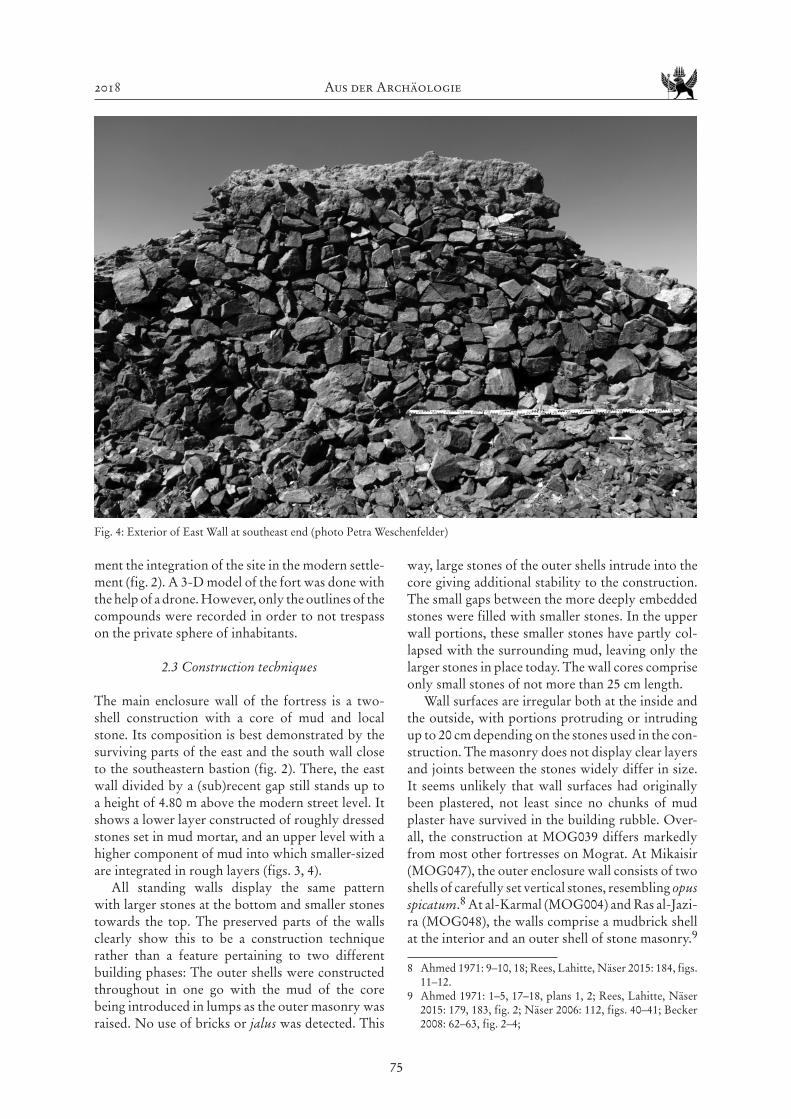
The only standing remains of the fortress are seg-ments of its main enclosure wall. Even they are visible above the current surface only in places (fig. 3). The best preserved wall segments are in the southeast corner where they still reach heights of up to 4.8 m above street level (see also chapter 4.1). This corner clearly displays the remains of a sub-circular bastion. Some parts of the north wall still rise up 1.1 m above the modern terrain. The remaining wall sections were only detectable as linear concentrations of stone col-lapse before the start of the archaeological investiga-tion. The outer measurements of the fortress are 48.6 m north-south and 44.30 m east-west, taken through the central point of the monument (fig. 2).
2.2 Methods of investigation and condition record
The architectural survey was undertaken from Janu-ary 18th to February 1st. First, a grid system was established based on twelve fixed points which were marked in the bedrock, fixated with concrete in one case, marked at the neighbouring water tower in another case.
All fortress walls detectable at the surface were recorded using a total station (fig. 2). Subsequently, invisible walls sections were traced in sondages along their presumed course in areas which were not cov-ered with extensive building collapse. For this, small
test pits were dug into the uppermost layer of mixed building collapse and recent rubbish dumping, in order to expose outer and inner wall contours. This way, about 55%, i.e. 108.8 m of the course of the outer face or the fortress enclosure wall could be identi-fied. In addition, the outlines of wall collapse and concentrations of disarticulated building material were recorded and added to the plan as dashed lines.
The southeast corner is not only its best preserved part, but also displays the least concentration of rubbish on the inside (fig. 3). Therefore, a sondage of 0.7 x 1.1 m was excavated in this part to explore its potential for reaching archaeologically relevant strata. However, the layer of burnt rubbish and ashes proved to be more than 1 m strong in this point, and the excavation had to be abandoned at that depth due to safety reasons. The investigation of the southeast bastion proved more successful. There, the link between the south wall and the southeast bastion could be investigated down to the bedrock (see below).
Since the visible wall sections did not produce any indication of primary accesses or gates, four areas of present-day access ways which consist in gaps in the main wall courses were also explored in sondages (fig. 2).
Apart from the fortress itself, also the surround-ing residential areas were surveyed in order to docu-
Fig. 3: Fortress interior at the southeast wall (photo Kai Kossatz)
2018 Aus der Archäologie
75
ment the integration of the site in the modern settle-ment (fig. 2). A 3-D model of the fort was done with the help of a drone. However, only the outlines of the compounds were recorded in order to not trespass on the private sphere of inhabitants.
2.3 Construction techniques
The main enclosure wall of the fortress is a two-shell construction with a core of mud and local stone. Its composition is best demonstrated by the surviving parts of the east and the south wall close to the southeastern bastion (fig. 2). There, the east wall divided by a (sub)recent gap still stands up to a height of 4.80 m above the modern street level. It shows a lower layer constructed of roughly dressed stones set in mud mortar, and an upper level with a higher component of mud into which smaller-sized are integrated in rough layers (figs. 3, 4).
All standing walls display the same pattern with larger stones at the bottom and smaller stones towards the top. The preserved parts of the walls clearly show this to be a construction technique rather than a feature pertaining to two different building phases: The outer shells were constructed throughout in one go with the mud of the core being introduced in lumps as the outer masonry was raised. No use of bricks or jalus was detected. This
way, large stones of the outer shells intrude into the core giving additional stability to the construction. The small gaps between the more deeply embedded stones were filled with smaller stones. In the upper wall portions, these smaller stones have partly col-lapsed with the surrounding mud, leaving only the larger stones in place today. The wall cores comprise only small stones of not more than 25 cm length.
Wall surfaces are irregular both at the inside and the outside, with portions protruding or intruding up to 20 cm depending on the stones used in the con-struction. The masonry does not display clear layers and joints between the stones widely differ in size. It seems unlikely that wall surfaces had originally been plastered, not least since no chunks of mud plaster have survived in the building rubble. Over-all, the construction at MOG039 differs markedly from most other fortresses on Mograt. At Mikaisir (MOG047), the outer enclosure wall consists of two shells of carefully set vertical stones, resembling opus spicatum.8 At al-Karmal (MOG004) and Ras al-Jazi-ra (MOG048), the walls comprise a mudbrick shell at the interior and an outer shell of stone masonry.9
8 Ahmed 1971: 9–10, 18; Rees, Lahitte, Näser 2015: 184, figs. 11–12.
9 Ahmed 1971: 1–5, 17–18, plans 1, 2; Rees, Lahitte, Näser 2015: 179, 183, fig. 2; Näser 2006: 112, figs. 40–41; Becker 2008: 62–63, fig. 2–4;
Fig. 4: Exterior of East Wall at southeast end (photo Petra Weschenfelder)
Aus der Archäologie MittSAG 29
76
Jalus was used as main building material at al-Hilla (MOG112) and Kudurma.10 Only the fortress of Kurta (MOG089) resembles MOG039 in the record-ed construction details (see below).
In the well-preserved part of the southeastern corner, the walls have a width of 2.3 m in their lower part close to the foundation, while their width ranges from 1.9 to 2 m in the upper parts. These figures are comparable to the widths of walls in Mikaisir (MOG047) and Kurta (MOG089).11
2.4 Architectural layout: groundplan,walls and bastions
The main enclosure walls form an irregular square (fig. 2). The northwest corner comes closest to a right angle while the opposite southeast corner is constructed forming an angle of 96°. The south wall is slightly curved, but meets again almost at a right angle with the west wall. The southwest corner is equipped with a bastion.
The original heights of the enclosure walls can no longer be detected. The east wall, being the best
10 Ahmed 1971: 10-11, 18–19; Rees, Lahitte, Näser 2015: 182, 194, 198, figs. 5, 28–30, 32–34; the fortress of Kudurma was visited this season and a 3D model of the fort with the help of a drone was prepared.
11 Rees, Lahitte, Näser 2015: 184, fig. 8.
preserved segment of the monument, still rises up to 4.8 m above the current street level. This level roughly corresponds with the level of the agricultural land that extends from 50 m distance to the east wall. The east wall is moreover closest to the Nile that is roughly 180 m to the east of the wall. Probably the wall was not much higher originally, as its width of c. 2.0 m does not allow for greater heights.
As stated above, the interior of the fortress is almost completely covered with a substantial accu-mulation of (sub)recent rubbish and wall collapse. Consequently, no walls could be detected inside the fort, except a low rectangular mudbrick wall in the southeast corner. Our investigation proved this wall to be sub-recent, however (see below).
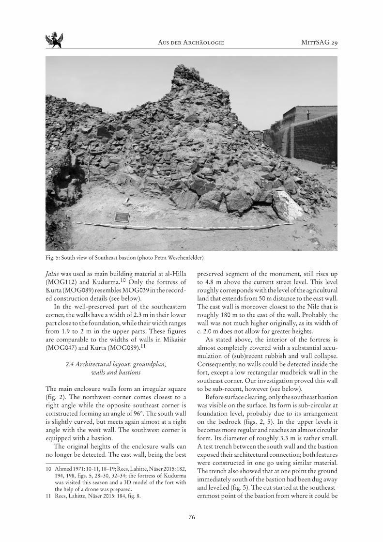
Before surface clearing, only the southeast bastion was visible on the surface. Its form is sub-circular at foundation level, probably due to its arrangement on the bedrock (figs. 2, 5). In the upper levels it becomes more regular and reaches an almost circular form. Its diameter of roughly 3.3 m is rather small. A test trench between the south wall and the bastion exposed their architectural connection; both features were constructed in one go using similar material. The trench also showed that at one point the ground immediately south of the bastion had been dug away and levelled (fig. 5). The cut started at the southeast-ernmost point of the bastion from where it could be
Fig. 5: South view of Southeast bastion (photo Petra Weschenfelder)
2018 Aus der Archäologie
77
followed west for four metres where it disappeared in the section of the trench.
During surface clearing, a second bastion was revealed in the southwest corner (fig. 2). Its size differs significantly from the southeast bastion. Its east-west length is about 7.7 m, its north-south width of 6.2 m. The transitions to the fortress walls are rounded with a radius of about 1.3 m. The three out-side corners are equally rounded yet with a slightly bigger radius of 1.6 to 1.7 m. The northwest corner is displaced, giving it an angular outline, but it can be assumed that it also had been rounded originally. The bedrock forms a promonitory of up to 4.5 m height above its surrounding to the southwest, and the bastion seems to have been placed on top of it, originally constituting a prominent landmark.
The outside course of the northwest corner could be established in the surface clearing. There, the walls form a right angle. Nevertheless, it cannot be excluded that a bastion had been inserted on the inside.12 Since the inside of the corner is covered with massive collapse, this question could not be followed up on the ground.
The northeast corner is not visible on the surface. While large sections of courses of the north and east walls could be identified, the final 9.5 m towards
12 We thank Gareth Rees for this suggestion.
the corner were hidden under massive (sub)recent accumulations. Present-day inhabitants use this area as an animal pen, and the surface is covered with large amounts of organic material. A small sondage undertaken in this area was abandoned at 0.4 m, as it still only produced recent organic material without signs of wall structures at that depth. The people liv-ing around that part of the fortress did not remember seeing either a corner or a bastion. However, satellite imagery suggests that trees and possibly agriculture thrived in this up to at least 2003 when a previous building, maybe another pen was also still indicated by ruins where the corner would be expected.13 This could account for the void in the fortress outline preserved at ground level. Moreover, the imagery showed that the housing had moved closer to the fortress walls especially in the east during the last fifteen years. Today, the compounds are too close to the potential corner of the fortress to allow for the excavation of a trial trench.
2.5 Access to the fort
As stated above, about 55% of the course of the outer face of the enclosure wall of the fortress could be identified. In between these sections there are sig-
13 Google Earth 7/2/2003.
Fig. 6: Continuation of wall below the modern access (photo Petra Weschenfelder)

Aus der Archäologie MittSAG 29
78
nificant gaps covered with trash, collapse and sand. In some parts these accumulations are higher than the remaining wall height and serve as pathways to cross the fort. Since modern situations could account for older practise two gaps in the west wall and the north wall were investigated in trial excavations (fig. 2).
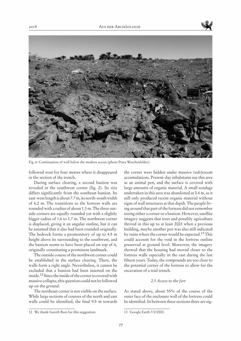
The course of the exterior face of the west wall has been traced almost completely, except for a gap north of the centre of the wall that was hidden underneath a high accumulation of debris and wall collapse. The sondage proved the absence of a historical access (fig. 6). Instead, alternating layers of walking hori-zons and organic material, tentatively identified as donkey dung, were exposed. The earliest pathway established in this sequence sat on top of a layer of wall collapse. This indicates that the wall continued through this section, without an original entrance.
The north wall features two current access ways, one on each side of a modern building whose south wall integrates parts of the fortress wall. The eastern access is also lined by a modern goat pen which is built over the potential course of the fortress wall. Both access ways connect to modern lanes of the settlement. A sondage in the western access way indi-cated the absence of a historical entrance. Instead the modern access runs on top of a layer of organic debris which may originate from an earlier goat pen, judg-ing from the dung in the section. Underneath this accumulation, the continuous course of the original fortress wall was exposed.
The above examples show that the modern use changes the site quite quickly. In 1971, Abbas Sid Ahmed described all the walls standing to at least one metre in height except for one gap. Nowadays, wall collapse and trash dump have reached the wall tops in many parts of the fortress. Today, the most pro-nounced gap – which may be identical with the gap described by Abbas – is situated in the east wall where it forms a deep depression used for a modern access way. Its position in the centre of the wall on the side of the fortress facing the river makes it the most plau-sible candidate for a historical main entrance. Due to time constraints and the huge amount of wall collapse and debris covering this area, a detailed investigation could not be implemented in the present season.
Finally, the southern fortress wall is relatively intact and large parts of its outer face could be identified during surface clearing. The central part of the wall is marked by a large accumulation of debris deriving from the original wall which indicates its continuation in this part. Moreover, the rocky, steeply sloping terrain make an entrance in this area rather unlikely. Today, the slope is covered with scat-tered animal pen and pits filled with trash.
2.6 Dating
While Ahmed (1971: 18) claims that Christian pot-tery was present at the site and that it has been the only pottery there, neither our surface clearing, nor the sondages produced dateable pottery relating to the construction or the use of the fortress. The only ceramic finds originate from the wall cores. They consist in two sherds found in the east wall and the south wall respectively; one could indicate that the mud which was used in the core was taken from an area which might have included a Neolithic site (fig. 7) and the other being an undecorated wheel-made body sherd (fig. 8). Until further investiga-tion which accesses archaeologically relevant layers underneath the heavy layers of rubbish and the wall collapse, the dating of MOG039 can only rest on comparison of its architectural and technological features with other dated fortresses.
The fortress on the island of Kurta (MOG089), c. 14 km downstream of Maqall holds a clue in this respect. Its architecture shows several parallels to MOG039.14 The walls are built in a similar way
14 Rees, Lahitte, Näser 2015: 181–182. The fortress on Kurta was visited again in the current season to verify the features used in the comparison of the two sites.
Fig. 7: Sherd found in East wall (photo Kai Kossatz)
Fig. 8: Sherd found in South wall (photo Kai Kossatz)
2018 Aus der Archäologie
79
with an inner core of mud and small stone and two outer shells of roughly dressed stones set in mud mortar. The width of the enclosure wall at Kurta is also similar to that of Maqall, amounting to 2 m. Ubiquitous pottery finds on the site surface indicate a dating of MOG089 in the Medieval period. The date is additionally supported by a box grave cemetery outside the fortress.
Obviously, a dating suggestion based on con-struction parallels holds significant challenges, since such building techniques can stay in use over an extended period of time, stretching over centuries and cultural breaks. Nevertheless, a medieval date for MOG039 is also supported by a clear difference in construction detail from the fortress of Mikaisir (MOG047; see above). In sum, it seems plausible that Maqall was part of a chain of fortresses securing the navigable main river channel on the northern side of Mograt Island in relatively regular intervals. This chain would have included Maqall (MOG039) in the east, Kurta (MOG089) and Ras el Gezira (MOG048) at the western end of this stretch of the river along the island.15 The latter two fortresses were dated into the Christian period.
3. The community’s insights – Local traditi-ons and (sub)recent use of the fortress
3.1 Research approach and methods
While the four approaches to public archaeology often oppose each other we tried to include them into our research16: Educational, since it included facilitating people’s interest in the past and archaeo-logical methods, public relations, since we tried to increase the communities recognition of the archaeo-logical work, pluralist, since we aimed at includ-ing the multi-vocal perspectives of the community members who keep diverse traditions concerning the site’s meaning, and critical, since often enough stories of local communities had been ignored in Sudanese archaeology if they related to a ‘post-use’ of a site. Especially the last point seems crucial in our research since often enough communities were discouraged to engage with their sites in the ways that were mean-ingful to them. Since, as Abu-Khafajah and Rababeh put it “cultural heritage is identified as a social com-munication process in which material of the past is encoded and decoded according to influences from contemporary contexts and ways of life, as well
15 Becker 2008; Billig 2008; Weschenfelder 2009.16 Matsuda 2016: 41-42.
as individuals’ experiences and perceptions”17, the exclusion of such stories and the sole focus on sci-entific evaluation can render a site meaningless for the local communities who live around it.
To discuss the stories handed down, Amel Hassan Gismillah, Rehab Ismael and Petra Weschenfelder undertook a two-week ethno-historical research visiting the families who live in the compound that immediately surround the fortress. Many members of those families had visited us during the archaeo-logical fieldwork, asked about the archaeology and history of the site, and invited us to come and visit. During our visits, several families who have family ties within the wider village accommodated visitors from those parts. Those visitors were also interested in sharing their stories and own perceptions of the stories that were told.18 Therefore, the stories we heard were not restricted to the immediate fortress neighbourhood. The research concerned the com-munities’ ideas about the fortress, the stories of the site’s use over the time and how the site could be integrated into the community in the future.
In each family, the visit started with an open biographical interview with the eldest of the present family members. We then focussed on those lifespans that the people spent in the village to find out about more about the varying views on the status of the fort and its history within the community. Especially the discussions among family members of different sex and age provided interesting insight into the transmission of local stories and history and the site’s inclusion in these stories. Some memories are shared within the community and concern logistical developments like the practise of getting drinking water directly from the river Nile despite the avail-ability of water from wells within some compounds and the changes connected to this practice after the installation of the water tank. Other stories however, seem to go along the differing live worlds of men and women in the village.
3.2 The fortress during the Mahdiya
One woman told us a story that seems to be transmit-ted especially within the female community of the
17 Abu-Khafajah & Rababeh 2014:73.18 This method had already provided valuable ethno-his-
torical insights in female live ways of Manāsir women in Kirbekān in the Fourth Cataract where the presence of several women discussing their perceptions and experi-ence revealed historical changes within the community that the women would not have reflected upon without the discussion (Weschenfelder 2012a: 78; Weschenfelder i.pr.).

Aus der Archäologie MittSAG 29
80
village. She was told by her aunt how the fortress was used during the Mahdiya. At that time women and children used the fortress as a shelter and refuge to hide from the fighting. Our consultant on this story is now about seventy-seven years old. She had heard the story in her youth after she had moved to the village due to her marriage. Her aunt at that time was allegedly more than eighty years old and therefore might even have experienced that use of the fort herself. The story was retold by another woman about a decade younger than the first storyteller.
This story seems not be have been transmitted among the men of the community. Only a few men claim to have heard about it when being asked direct-ly but other even did not have any knowledge about this history of use of the fortress. Their tradition of the Mahdiya period concentrated on the fights. Men from the village went to Abu Hamed to fight there. That part would tie in with the story of the women who claim that the men had gone away to fight while they hid in the fortress. The fights seem to have had a longer impact on the area. One man told us that when he regularly commuted to Abu Hamed in the 1950s people could still find body parts from the fighters in the area around the ferry service.
While the focus on this part of local history can be interpreted in various ways, one way being the association with the family’s ancestors, another being the legitimacy of land use in referring to the ances-
tors’ use of the site. A third aspect that could be discussed here is a current trend in heritage focus in several countries on the African continent that seems to interpret sites as liberation heritage associ-ated with the fight for independence from colonial rule. This seems to be celebrated on national level in South Africa, Zambia, and Mozambique.19 Yet, this appears not to be a feature of local heritage manage-ment on Mograt Island. The stories seem to rather connect the people to the history of their ancestors.
3.3 Sub-recent additions in and at the fortress
Exclusive knowledge also concerned another aspect of the fort’s use in more recent times and explains the better preserved southern inside of the fort (chap-ter 2). As men and women told us there had been a local Islamic sheikh Fakhi Hamed20 who had been known as a consultant in questions of mental ill-nesses. Some people told us that he had lived in the fort. Others told that he had been buried in the fort while even other people said that after the sheikh’s death and his burial elsewhere the inhabitants of the village had built a structure for his commemoration where people could go and ask for godly guidance
19 Cf. Ndoro & Chirikure 2018: 242.20 In contrast to a political sheikh who acts as a leader in local
politics the Islamic sheikh has religious influence due to his acknowledged piety or outstanding Islamic learning.
Fig. 9: North face of sheikh’s place before superficial cleaning (photo Petra Weschenfelder)
2018 Aus der Archäologie
81
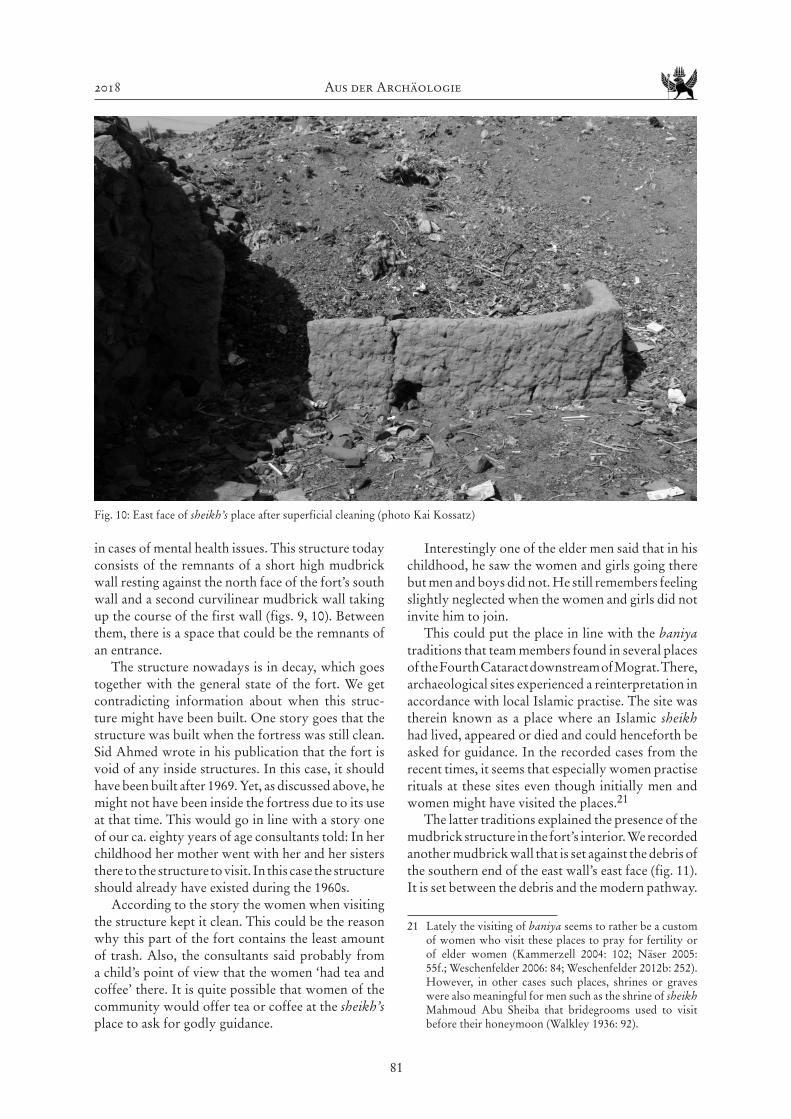
in cases of mental health issues. This structure today consists of the remnants of a short high mudbrick wall resting against the north face of the fort’s south wall and a second curvilinear mudbrick wall taking up the course of the first wall (figs. 9, 10). Between them, there is a space that could be the remnants of an entrance.
The structure nowadays is in decay, which goes together with the general state of the fort. We get contradicting information about when this struc-ture might have been built. One story goes that the structure was built when the fortress was still clean. Sid Ahmed wrote in his publication that the fort is void of any inside structures. In this case, it should have been built after 1969. Yet, as discussed above, he might not have been inside the fortress due to its use at that time. This would go in line with a story one of our ca. eighty years of age consultants told: In her childhood her mother went with her and her sisters there to the structure to visit. In this case the structure should already have existed during the 1960s.
According to the story the women when visiting the structure kept it clean. This could be the reason why this part of the fort contains the least amount of trash. Also, the consultants said probably from a child’s point of view that the women ‘had tea and coffee’ there. It is quite possible that women of the community would offer tea or coffee at the sheikh’s place to ask for godly guidance.
Interestingly one of the elder men said that in his childhood, he saw the women and girls going there but men and boys did not. He still remembers feeling slightly neglected when the women and girls did not invite him to join.
This could put the place in line with the baniya traditions that team members found in several places of the Fourth Cataract downstream of Mograt. There, archaeological sites experienced a reinterpretation in accordance with local Islamic practise. The site was therein known as a place where an Islamic sheikh had lived, appeared or died and could henceforth be asked for guidance. In the recorded cases from the recent times, it seems that especially women practise rituals at these sites even though initially men and women might have visited the places.21
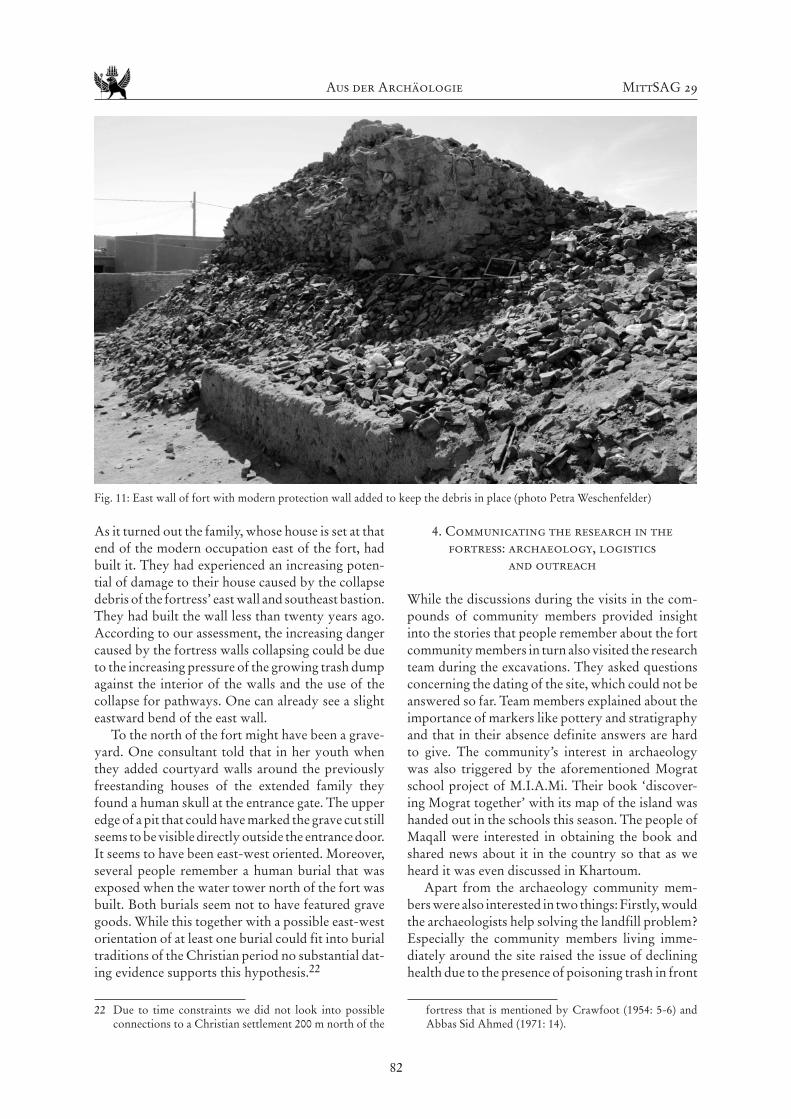
The latter traditions explained the presence of the mudbrick structure in the fort’s interior. We recorded another mudbrick wall that is set against the debris of the southern end of the east wall’s east face (fig. 11). It is set between the debris and the modern pathway.
21 Lately the visiting of baniya seems to rather be a custom of women who visit these places to pray for fertility or of elder women (Kammerzell 2004: 102; Näser 2005: 55f.; Weschenfelder 2006: 84; Weschenfelder 2012b: 252). However, in other cases such places, shrines or graves were also meaningful for men such as the shrine of sheikh Mahmoud Abu Sheiba that bridegrooms used to visit before their honeymoon (Walkley 1936: 92).
Fig. 10: East face of sheikh’s place after superficial cleaning (photo Kai Kossatz)
Aus der Archäologie MittSAG 29
82
As it turned out the family, whose house is set at that end of the modern occupation east of the fort, had built it. They had experienced an increasing poten-tial of damage to their house caused by the collapse debris of the fortress’ east wall and southeast bastion. They had built the wall less than twenty years ago. According to our assessment, the increasing danger caused by the fortress walls collapsing could be due to the increasing pressure of the growing trash dump against the interior of the walls and the use of the collapse for pathways. One can already see a slight eastward bend of the east wall.
To the north of the fort might have been a grave-yard. One consultant told that in her youth when they added courtyard walls around the previously freestanding houses of the extended family they found a human skull at the entrance gate. The upper edge of a pit that could have marked the grave cut still seems to be visible directly outside the entrance door. It seems to have been east-west oriented. Moreover, several people remember a human burial that was exposed when the water tower north of the fort was built. Both burials seem not to have featured grave goods. While this together with a possible east-west orientation of at least one burial could fit into burial traditions of the Christian period no substantial dat-ing evidence supports this hypothesis.22
22 Due to time constraints we did not look into possible connections to a Christian settlement 200 m north of the
4. Communicating the research in the fortress: archaeology, logistics
and outreach
While the discussions during the visits in the com-pounds of community members provided insight into the stories that people remember about the fort community members in turn also visited the research team during the excavations. They asked questions concerning the dating of the site, which could not be answered so far. Team members explained about the importance of markers like pottery and stratigraphy and that in their absence definite answers are hard to give. The community’s interest in archaeology was also triggered by the aforementioned Mograt school project of M.I.A.Mi. Their book ‘discover-ing Mograt together’ with its map of the island was handed out in the schools this season. The people of Maqall were interested in obtaining the book and shared news about it in the country so that as we heard it was even discussed in Khartoum.
Apart from the archaeology community mem-bers were also interested in two things: Firstly, would the archaeologists help solving the landfill problem? Especially the community members living imme-diately around the site raised the issue of declining health due to the presence of poisoning trash in front
fortress that is mentioned by Crawfoot (1954: 5-6) and Abbas Sid Ahmed (1971: 14).
Fig. 11: East wall of fort with modern protection wall added to keep the debris in place (photo Petra Weschenfelder)
2018 Aus der Archäologie
83
of their door steps. It also became obvious that the children who do not attend kindergarten play in the fortress among used syringes, run-out batteries and broken glass.
The peoples’ second question was if the archaeo-logical work would raise the site’s potential to attract tourists? It was quite evident that in the current state as landfill this potential is non-existent. But some community members hope that if the problem can be solved the potential would grow.
As Fushiya and De Trafford pointed out concern-ing the Egyptian site of Abou Roash, the use of an archaeological site for landfill does not mean that community members do not appreciate their herit-age.23 In case of Maqall it is obvious that the devel-opment of housing around the site within the recent decades together with the neglect of the infrastruc-tural development led to the point when community members hardly saw an alternative to using the only space free of modern construction, i.e. the fortress, for landfill. The fact that community members raised the issue shows that there is concern regarding this development. Therefore, Mohammed Mohammed el-Tayeb Badri, who manages M.I.A.Mi. logistics and its liaison with political stakeholders, contacted the local manager of waste disposal for the market of Maqall who is contracted by the local government in Abu Hamed. With him a superficial cleaning of the fort was negotiated to remove the worst of broken glass, syringes and plastic (cf. figs. 9, 10). Moreover, the team negotiated with him and the Governor of Abu Hamed a regular weekly trash transport service for the community around the fort. While it is still in question if the system will eventually work it is a first step that shows that a local system can be developed.
The second issue can of course not be predicted at the current state of the research. So far, Maqall fortress would count as a non-use value site, situated in a rural area away from and not promoted by tourist route plans, with many parts of the structure being lost, without signage and visitor facilities. However, the discussion above shows that Maqall fortress holds potential regarding social, cultural/symbolic, spiritual as well as historical value within the com-munity24 and could thereby become a heritage site shaping ideas of identity and belonging of its present communities.25 In this context it is interesting to hear the reasoning why people see potential benefits in developing tourism on the site which does not so much concern immediate job opportunities but
23 Fushiya & De Trafford 2009: 50-54.24 Cf. Fushiya & De Trafford 2009: 45-47.25 Cf. Góral 2015: 56f.
rather a long term perspective.26 Several members had lived and worked all over Sudan in construction and engineering. Many people receive pensions now and are independent from more income from tour-ism. However, they are concerned with the youth of the village leaving due to job opportunities in the cit-ies (see below) and hope that jobs in tourism would raise the potential that the young people stay in the community. Thereby their interest in developing tourism clearly includes social dimensions.27
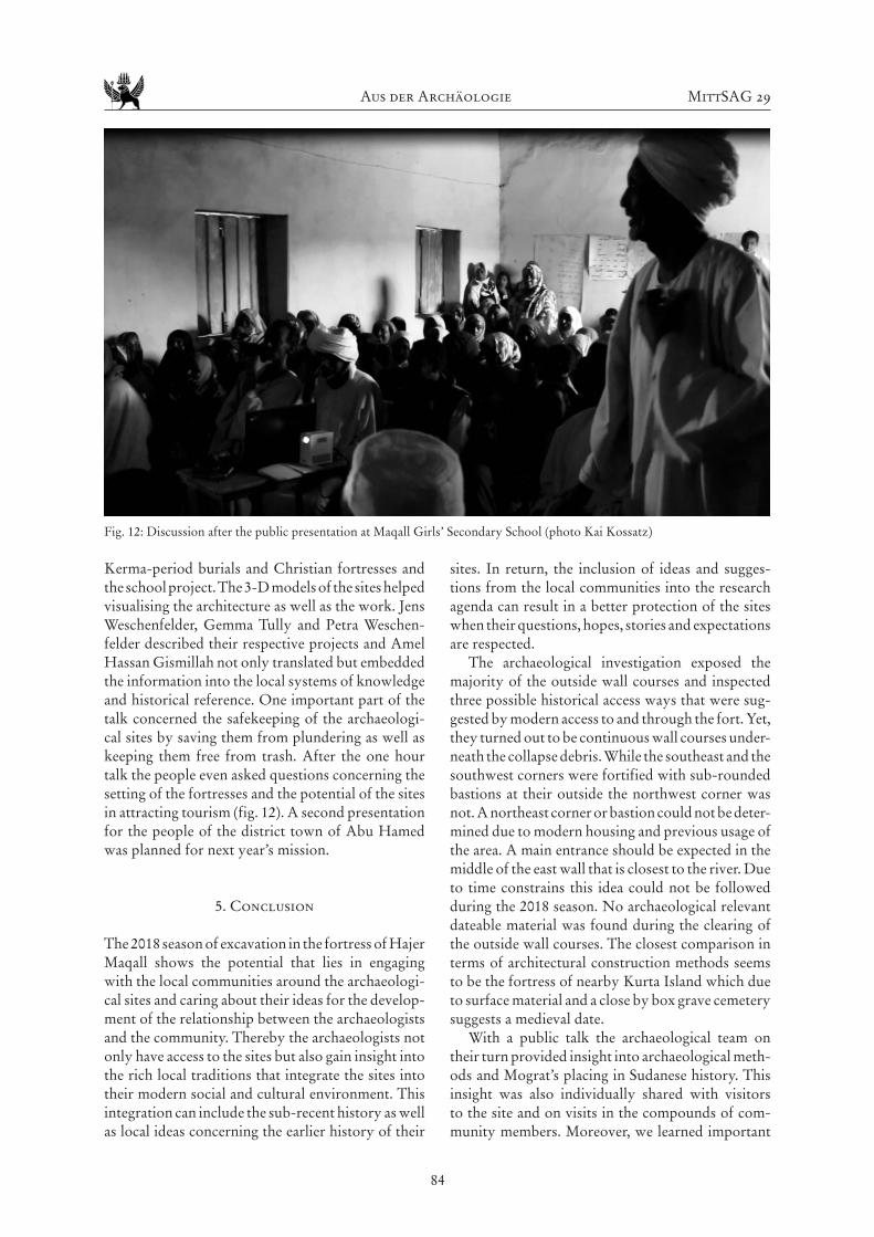
Due to our work and their interest in the book members of the community voiced interest in a pub-lic presentation on archaeology. Spokesmen of the village invited us to give the presentation in the local club. Talking to the women of the village we found out that they would not be able to attend a talk in that location because it is reserved for male com-munity members.
As it seems the village of Maqall represents a field of negotiations between old traditions and new practices, negotiations that can be found in many rural communities nowadays. During the last years many opportunities opened up for young people to work in the big cities particularly Khartoum espe-cially after infrastructural developments like regular bus transport. As a result even young unmarried women from the village now work in Khartoum as financial consultants in a bank or run a pharmacy. However, while especially young women supported by their wider family networks that provide hous-ing in Khartoum embrace these opportunities their home villages retain in their old traditions that often enough do not support public female engagement in community politics. The young women visiting from Khartoum told that in Maqall the men even prohibit them to go to the local market and the club is completely off limits for them.28
A more inclusive location was found in the local girls’ secondary school where men and women occu-pied one side of the room each. The people not only from the village but even neighbouring vil-lages intensely listened to stories of Neolithic and
26 Cf. for the Meroe area Humphris & Bradshaw 2017: 210, fig. 4.
27 Cf. Góral 2015: 57f.28 Petra Weschenfelder had met similar issues before in the
village of El Kurru. There, an evening presentation for the women of the village had been agreed upon in the compound of the local sheikh. The presentation was well received but as it turned out the women of the community who were not related to the sheikh’s family could not attend since they would not be allowed to go to the house after sunset without the company of a male family mem-ber. The male family members however, were excluded by default since it was a presentation for the women.
Aus der Archäologie MittSAG 29
84
Kerma-period burials and Christian fortresses and the school project. The 3-D models of the sites helped visualising the architecture as well as the work. Jens Weschenfelder, Gemma Tully and Petra Weschen-felder described their respective projects and Amel Hassan Gismillah not only translated but embedded the information into the local systems of knowledge and historical reference. One important part of the talk concerned the safekeeping of the archaeologi-cal sites by saving them from plundering as well as keeping them free from trash. After the one hour talk the people even asked questions concerning the setting of the fortresses and the potential of the sites in attracting tourism (fig. 12). A second presentation for the people of the district town of Abu Hamed was planned for next year’s mission.
5. Conclusion
The 2018 season of excavation in the fortress of Hajer Maqall shows the potential that lies in engaging with the local communities around the archaeologi-cal sites and caring about their ideas for the develop-ment of the relationship between the archaeologists and the community. Thereby the archaeologists not only have access to the sites but also gain insight into the rich local traditions that integrate the sites into their modern social and cultural environment. This integration can include the sub-recent history as well as local ideas concerning the earlier history of their
sites. In return, the inclusion of ideas and sugges-tions from the local communities into the research agenda can result in a better protection of the sites when their questions, hopes, stories and expectations are respected.
The archaeological investigation exposed the majority of the outside wall courses and inspected three possible historical access ways that were sug-gested by modern access to and through the fort. Yet, they turned out to be continuous wall courses under-neath the collapse debris. While the southeast and the southwest corners were fortified with sub-rounded bastions at their outside the northwest corner was not. A northeast corner or bastion could not be deter-mined due to modern housing and previous usage of the area. A main entrance should be expected in the middle of the east wall that is closest to the river. Due to time constrains this idea could not be followed during the 2018 season. No archaeological relevant dateable material was found during the clearing of the outside wall courses. The closest comparison in terms of architectural construction methods seems to be the fortress of nearby Kurta Island which due to surface material and a close by box grave cemetery suggests a medieval date.
With a public talk the archaeological team on their turn provided insight into archaeological meth-ods and Mograt’s placing in Sudanese history. This insight was also individually shared with visitors to the site and on visits in the compounds of com-munity members. Moreover, we learned important
Fig. 12: Discussion after the public presentation at Maqall Girls’ Secondary School (photo Kai Kossatz)

2018 Aus der Archäologie
85
facts about the fort by including the more recent reuse of the site.29 From the discussion with com-munity members, two mudbrick structures could be identified as sub-recent and their history told. Moreover, working together with the community we also learned about the subrecent use of the site and its integration into the local history. It became clear that the communities around the fortress value the site for its role in the more recent history that connects them with the lives of their grandparents’ generation rather than for its potential medieval history, even though they are not uninterested in this period either (cf. Weschenfelder this volume). By telling the stories of their family members, they link their own family history during the Mahdiya to that of the site.
Even though, the Mahdiya period has no direct connection with the original use of the site such “sto-ries anchor archaeological sites to the present and thereby transform them into cultural heritage”30. The people of Hajer Maqall were proud that they could tell us these stories about the fortress. If we really want the local communities to care for their sites we need to consider their ways to connect to the archaeology. This way sites could become herit-age places whose community members actively care for the site.31 The fortress thereby holds historical, social, spiritual and cultural value within the commu-nity which could be considered in a potential future development of the site as a heritage site.
Bibliography
Abbas Sid Ahmed (1971) The Antiquities of Mograt Island.
Sudan Notes and Records 52, 1-21.
Abu-Khafajah, S. & S. Rababeh (2014) The Silence of
Meanings in Conventional Approaches to Cultural
Heritage in Jordan: The Exclusion of Contexts and
the Marginalisation of the Intangible. In M. Stefano,
P. Davis & G. Corsane (eds) Safeguarding Intangible
Cultural Heritage. Woodbridge: Boydell: 71-84.
Becker, P. (2008) H.U.N.E. 2008: Die Festung Ras al Gazi-
ra (MOG048) auf der Insel Mograt. Der Antike Sudan.
Mitteilungen der Sudanarchäologischen Gesellschaft
zu Berlin e.V. 19, 61-67.
Billig, D. (2008) H.U.N.E. 2008: Grabung innerhalb der
Festung MOG048. Der Antike Sudan. Mitteilungen
der Sudanarchäologischen Gesellschaft zu Berlin e.V.
19, 69-76.
29 Cf. de Vries 2013: 138-139.30 Abu-Khafajah & Rababeh 2014: 71.31 Cf. Isherwood 2013: 88-91.
Crawford, O. (1953) Field Archaeology of the Middle Nile
region. Kush 1, 2-29.
Fushiya, T. & A. De Trafford (2009) From Site to Society:
From a Garbage Dumping Place to a Local Heritage
Site. In F. Hassan, G. Tassie, A. De Trafford, L. Owens
& J. van Wetering (eds.) Managing Egypt´s Cultural
Heritage. Vol. 1. London: Golden House: 38-58.
Góral, A. (2015) Cultural Heritage as a Shared Resource.
The Role of Collaboration Between Stakeholders in
Cultural Heritage Management. In Ł. Gaweł & E.
Kocój (eds.) Cultural Heritage. Management, Identity
and Potential. Krakow: Jagiellonian University Press:
55-66.
Humphris, J. & R. Bradshaw (2017) Understanding
‘the Community’ Before Community Archaeol-
ogy: A Case Study from Sudan, Journal of Com-
munity Archaeology & Heritage 4:3, 203-217, DOI:
10.1080/20518196.2017.1345364.
Isherwood, R. (2013) Rediscovering, Preserving and Mak-
ing Memories at Community Archaeology Projects.
In I. Dalglish (ed.) Archaeology, the Public and the
Recent Past. (The Society for Post-Medieval Archaeol-
ogy Monograph 7). Woodbridge: 77-92.
Jones, S. (2017) Wrestling with the Social Value of Heritage:
Problems, Dilemmas and Opportunities. Journal of
Community Archaeology & Heritage 4:1, 21-37, DOI:
10.1080/20518196.2016.1193996.
Kammerzell, F. (2004) Die Humboldt University Nubian
Expedition (H.U.N.E.) in Dar al-Manasir - Erster Ber-
icht: Survey 2004, Teil 1: Rahmenbedingungen. Der
Antike Sudan. Mitteilungen der Sudanarchäologischen
Gesellschaft zu Berlin e.V. 15, 99-104.
Matsuda, A. (2016) A Consideration of Public Archaeol-
ogy Theories. Public Archaeology 15 (1), 40-49.
Näser, C. (2005) Die Humboldt University Nubian Expe-
dition 2005. Arbeiten im Bereich der Inselkonzession.
Der Antike Sudan. Mitteilungen der Sudanarchäologis-
chen Gesellschaft zu Berlin e.V. 16, 49-67.
Näser, C. (2006) Die Humboldt University Nubian
Eexpedition 2006. Arbeiten aus Us und Mograt. Der
Antike Sudan. Mitteilungen der Sudanarchäologischen
Gesellschaft zu Berlin e.V. 17, 89-116.
Ndoro, W. & S. Chirikure (2018) Caring Matters. The
Future of Managing Heritage in Africa. In W. Ndoro,
S. Chirikure & J. Deacon (eds.) Managing Heritage in
Africa. Who Cares? London, New York: Routledge:
237-250.
Rees, G., Lahitte, M., C. Näser (2015) The Fortresses of
Mograt Island Project. Der Antike Sudan. Mitteilungen
der Sudanarchäologischen Gesellschaft zu Berlin e.V.
26, 177-200.
Skinner, E. (2012) Intimate Knowledge: Defining Heritage
from the Inside. In I. Robertson (ed.) Heritage from
Below. Farnham: Ashgate: 109-124.
Aus der Archäologie MittSAG 29
86
Tully, G. (2015) Community Archaeology in Sudan: Dis-
covering Mograt Island Together. Der Antike Sudan.
Mitteilungen der Sudanarchäologischen Gesellschaft
zu Berlin e.V. 26, 201-204.
DeVries, B. (2013) Archaeology and Community in Jordan
and Greater Syria: Traditional Patterns and New Direc-
tions. Near Eastern Archaeology 76: 3 (Special Issue on
Public Archaeology: Collaborative and Community
Approaches), 132-141.
Walkley, C. (1936) The Story of Khartoum (Concluded).
Sudan Notes and Records 19, 71-92.
Weschenfelder, P. (2006) H.U.N.E. 2006: Alltagsleben der
Frauen im Dorf Kirbekān. Der Antike Sudan. Mit-
teilungen der Sudanarchäologischen Gesellschaft zu
Berlin e.V. 17, 81-88.
Weschenfelder, P. (2009) Die Keramik von MOG048. Der
Antike Sudan. Mitteilungen der Sudanarchäologischen
Gesellschaft zu Berlin e.V. 20, 93-99.
Weschenfelder, P. (2012a) Mânâsir Women’s Contribu-
tion to Economic and Social Life: A Case Study From
Kirbekân in Dâr al-Manâsîr. In Kleinitz, C. & C. Näser
(eds.) “Nihna nâs al-bahr - we are the people of the
river” Ethnographic Research in the Fourth Nile Cata-
ract Region, Sudan. Wiesbaden: 75-87.
Weschenfelder, P. (2012b) Life and Tradition of Manasir
Women in Kirbekān. In H.-P. Wotzka (ed.) Proceed-
ings of the Third International Conference on the
Archaeology of the Fourth Nile Cataract. Cologne:
249-256.
Weschenfelder, P. (i. pr.) A Collective Gender Perception?
Female Perspectives Towards Resettlement in Dar al-
Manâsîr, Dotawo. A Journal of Nubian Studies 5.
Zusammenfassung
Die wissenschaftliche Untersuchung der Festung von Maqall (MOG039) auf der Insel Mograt im Januar 2018 wurde als community archaeology Projekt durchgeführt. Neben der archäologischen Untersuchung der Festung zielte das Projekt ebenso darauf ab, die Familien, die um die Festung herum leben, an der Forschung teilhaben zu lassen, ihre Vorstellungen für die Entwicklung des Fundplatzes aufzunehmen und wo möglich einzubeziehen und zudem herauszufinden, wo sie die Bedeutung des Fundplatzes sehen.
Die archäologische Untersuchung wurde von Besuchen der ansässigen Familien begleitet, die sehr interessiert waren an den Methoden, aber vor allem auch an der geschichtlichen Verortung ihrer Insel in der sudanesischen Geschichte. Zu diesen Punkten hielt das Grabungsteam eine öffentliche Vorlesung, die mit sehr positiver Resonanz nicht nur von den
Bewohnern des Festungsdistrikts besucht wurde, sondern auch Bewohnern weiter entfernter Orte auf der Insel teilnahmen.
Zu den Herausforderungen des archäologischen Fundplatzes zählte der Umstand, dass er mangels alternativer Infrastruktur in Maqall seit mindestens siebzig Jahren als Schutthalde und Müllablage platz fungierte. Die Vorstellungen zur Entwicklung des Fundplatzes seitens der Bewohner des Festungs-distrikts kreisten entsprechend zuerst um die Lösung des Müllablageproblems, denn nicht nur verursachen die oftmals giftigen Abfälle mittlerweile Gesundheitsprobleme unter den Anwohnern, auch nutzen viele Kinder die Festung als Spielplatz und spielen entsprechend zwischen benutzten Spritzen, Glasbruch, Hausmüll und Tierkadavern. Mit dem Manager für Abfallentsorgung des nahegelegenen Marktplatzes konnte das Grabungsteam eine ober-flächliche Reinigung der Festung aushandeln, um die gefährlichsten Anteile des Mülls zu entfernen, sowie eine wöchentliche Müllabholung vor der Festung.
In der knapp zweiwöchigen archäologischen Kampagne konnte die Festung in Maqall, die bis-lang noch nicht untersucht wurde, in ihren Umriss geklärt werden. Hierzu wurde zunächst eine ober-flächliche Reinigung der Festungsfläche vorgenom-men. Danach wurde in den Bereichen, in denen die Außenmauer nicht durch große Schutthaufen bedeckt ist, durch lineare Sondagen der Verlauf der nahe an der Oberfläche befindlichen Mauerkanten geklärt. In der Regel wurde hierbei nur oberflächlich der Schutt in einem schmalen Streifen beräumt, bis die Mauerkante gut erkennbar und von eventuellen Versturz klar zu unterscheiden war. Dabei konnte ein Großteil des ursprünglichen Verlaufs der Festungs-außenmauer geklärt werden.
Von den ursprünglich vorhandenen Außenmau-ern der Festung sind nur wenige Reste erhalten, die sich über das Niveau erheben. Am auffälligsten ist dabei die Südostecke, die sich in einigen Teilen noch bis zu 4,80 m über das heutige Straßenniveau erhebt und durch eine Bastion verstärkt ist. Sie ist mit einem Radius von ca. 1,65 m relativ klein.
Im Zuge der Mauerklärung wurde an der Süd-westecke eine zweite Bastion gefunden. Diese unterscheidet sich durch ihre Größe deutlich von der Bastion an der der Südostecke. Die Länge in Ostwestrichtung beträgt ca. 7,70 m, die Breite in Nordsüdrichtung ca. 6,20 m. Die Anschlüsse zu den Festungsaußenmauern sind mit einem Radius von ca. 1,30 m gerundet. Die drei Außenecken der Bastion sind ebenfalls gerundet. Die Festungsmauer besteht aus einer innen- und außenseitigen Schale aus zum Teil sehr kleinteiligem Bruchsteinmauerwerk

2018 Aus der Archäologie
87
aus dem lokalen Naturstein und einer Füllung aus Lehm, die ebenfalls mit Bruchstücken des lokalen Steins versetzt ist. Die Breite der Mauern beträgt im unteren Bereich nahe der Gründung ca. 2,30 m, im oberen Bereich zwischen 1,90 und 2,00 m. Die Oberflächen der Mauern sowohl innen wie auch außen sind sehr unregelmäßig.
Von den ursprünglich erhaltenen Eingängen ins Festungsinnere ist heute oberflächlich nichts mehr sichtbar. Durch die Klärung des Mauerverlaufs in weiten Bereichen konnten jedoch die möglichen Bereiche für einen Eingang zumindest stark ein-geschränkt werden. An der Südseite sind Teile der Mauer noch gut erhalten, zusätzlich konnte ein gro-ßer Teil des Mauerverlaufs außenseitig gefasst wer-den. Im mittleren Bereich der Mauer ist ein starker Versturz der ursprünglichen Festungsmauer vorhan-den, der auf einen durchgehenden Verlauf der Mauer in diesem Bereich schließen lässt. Hinzu kommt der relativ steile, felsige Abhang zur Ebene auf die-ser Seite. Dies zusammengenommen, macht einen Zugang von Süden unwahrscheinlich. Der Verlauf der Westmauer konnte in einem ersten Schritt bis auf eine Lücke im Bereich des heutigen Zugangs außenseitig geklärt werden. Es konnte keine Unter-brechung des Mauerwerks festgestellt werden. Der heutige Hauptzugang befindet sich in der nördlichen Hälfte der Westmauer, aber relativ nahe zur Mitte des Mauerverlaufs. Dieser Zugang wurde geson-dert untersucht, um zu klären, ob er die Tradition des historischen Zugangs weiterführt. Die Unter-suchung erbrachte ein Durchlaufen der Festungs-mauer in tieferen Schichten. Es kann also als geklärt betrachtet werden, dass sich in der Westmauer kein bauzeitlicher Zugang ins Festungsinnere befand. Die Ostmauer konnte in Ihrem Verlauf mit Ausnahme des modernen Zugangs und der letzten 9,50 m vor der Nordostecke außenseitig gefasst werden. Der moderne Zugang bildet hier einen tiefen Einschnitt in den Mauerverlauf. Seine Lage in der Mitte der Mauer sowie in Richtung zum Fluss lassen diesen Bereich als wahrscheinlichste Position für einen Ein-gang erscheinen. Leider ist eine Untersuchung dieses Bereichs auf Grund der hier vorhandenen großen Schuttmassen nicht möglich.
Aufgrund der Befundlage in Maqall wurde leider keine diagnostische Keramik gefunden. Eine Datie-rung der Festungsanlage kann daher nur über bau-technisch vergleichbare Festungen, die bereits datiert sind, erfolgen. In unmittelbarer Nähe, circa 14 km flussabwärts, auf der Insel Kurta (MOG 089) befin-det sich eine Festung die einige Parallelen zu Maqall aufweist. Die Mauern sind in gleicher Bauweise aus einer Schale aus Bruchsteinen und einer Lehm-Stein-
füllung aufgebaut. Die Wandstärke ist mit ca. 2,00 m ähnlich wie in Maqall. In der Festung ist eine Vielzahl von keramischen Bruchstücken oberflächlich vor-handen, die ins Mittelalter datiert werden können. Es bleibt immer schwierig, eine Datierung nur über bautechnische Vergleiche vorzunehmen, da Bau-techniken in der Regel über einen langen Zeitraum verwendet werden können. Trotzdem scheint auf der Grundlage der baulichen Parallelen und der räumli-chen Nähe zu Kurta eine Datierung der Festung in Maqall ins Mittelalter plausibel.
Durch ethnohistorisch inspirierte Diskussio-nen mit Familien, die um die Festung herum leben, konnte die Festung darüber hinaus in die neuere Geschichte des Sudan eingebettet werden. Frauen tradieren dazu, dass während der Mahdiya sich die Frauen und Kinder in der Festung versteckten, wäh-rend die Männer kämpften. Die Männer tradieren die Kämpfe in Abu Hamed. In jüngerer Zeit ist ein Lehmziegelbau im südöstlichen Viertel der Festung zu datieren. Sie ist assoziiert mit einem islamischen Weisen, der sich zu Lebzeiten durch besondere Pietät und Wissen um mentale Krankheiten hervortat und zu dessen Ehren und Bitten um Vermittlung zu Gott nach seinem Tod die Stätte errichtet wurde. Frauen, die gegenwärtig in ihren 80ern und 70ern sind, erin-nern sich daran, ihre Mütter dorthin begleitet zu haben, die wohl Tee und Kaffee dorthin brachten. Sie hielten den Platz sauber, weswegen er heute die geringste Ansammlung von Abraum und Müll auf-weist. Eine weitere Lehmziegelmauer an der Außen-seite der Südostbastion ist noch jüngeren Datums; sie wurde von den Anwohnern vor weniger als zwanzig Jahren angebracht, um ihr Haus vor den von der Festung abfallenden Steinen zu schützen. Der Nie-dergang auch dieses noch am besten erhaltenen Teils der Festung hängt vermutlich mit der anwachsenden Mülllast im Inneren zusammen.
Durch die Geschichten und Erzählungen der Anwohner des Festungsviertels konnten also nicht nur Einzelfragen zu Bauten an und in der Festung geklärt werden. Ebenso konnte gezeigt werden, dass die Festung, wenngleich vermutlich ins Mittelalter datierend, dennoch von den gegenwärtigen Bewoh-nern als historisch bedeutungsvoll angesehen wird. Die historische Bedeutung fokussiert jedoch auf das späte 19. Jh., auf das die heutigen Bewohner mit Familiengeschichten verweisen können. Die Beach-tung der Interessen und Ansichten der Familien um die Festung herum bereicherten sowohl die For-schung selbst als auch die Forschungsergebnisse. Zudem kann dieses Wissen in eine mögliche Planung zur Entwicklung des Fundplatzes als Ort des lokalen kulturellen Erbes einfließen.
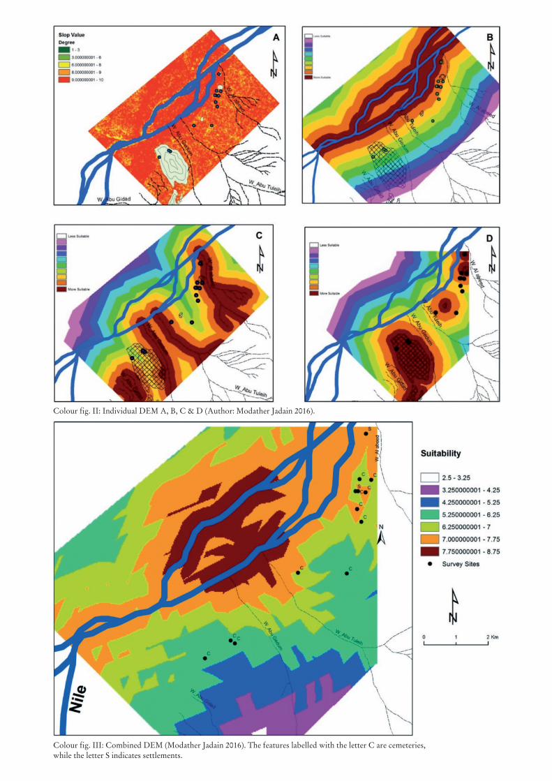
Colour fig. II: Individual DEM A, B, C & D (Author: Modather Jadain 2016).
Colour fig. III: Combined DEM (Modather Jadain 2016). The features labelled with the letter C are cemeteries,while the letter S indicates settlements.
•
Heft29•2018
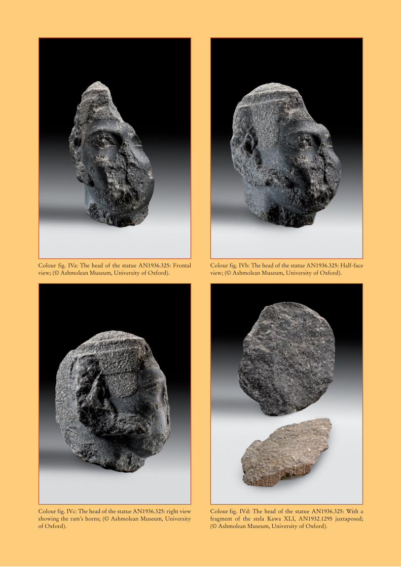
Colour fig. IVa: The head of the statue AN1936.325: Frontal view; (© Ashmolean Museum, University of Oxford).
Colour fig. IVb: The head of the statue AN1936.325: Half-face view; (© Ashmolean Museum, University of Oxford).
Colour fig. IVc: The head of the statue AN1936.325: right view showing the ram’s horns; (© Ashmolean Museum, University of Oxford).
Colour fig. IVd: The head of the statue AN1936.325: With a fragment of the stela Kawa XLI, AN1932.1295 juxtaposed; (© Ashmolean Museum, University of Oxford).