holocene soils and soil-geomorphic relations in a semiarid region of southern new mexico
TRANSCRIPT

QUATERNARY RESEARCH 7, 112- 132 (1977)
Holocene Soils and Soil-Geomorphic Relations in a Semiarid Region of Southern New Mexico
LELAND H. GILE
Soil Survey Investigations, Soil Conservation Service, P.O. Box 6567, Fort Worth, Texas 76115
Received June 9, 1975
Holocene soils of a semiarid area in southern New Mexico occur on terraces and fans in and adjacent to the mountains. The illustrative soils have formed in alluvium derived from rhyolite, monzonite, and sedimentary rocks, mainly limestone.
A large arid basin occurs downslope from the mountains. In the arid-semiarid transition, the effect of a gradual increase in precipitation on soil morphology is shown by Holocene soils that sensitively reflect the precipitation. Where the parent materials contain little or no carbonate, a surficial noncalcareous zone and a reddish-brown horizon of silicate clay accumulation thicken mountainward as precipitation increases. The Bt horizon is underlain by the carbonate horizon, the upper boundary of which deepens mountainward. These orographic-depth relations and soil morphology support an interpretation that some of the clay (as well as the carbonate) is of illuvial origin. In high-carbonate parent materials, a noncalcareous zone has not developed and a reddish-brown horizon of clay accumulation has not formed.
In upper horizons, organic carbon increases and color darkens towards the mountains. This causes a change in soils at the categorical level of soil order; Mollisols do not occur in the arid basin downslope, where nearly all Holocene soils are either Aridisols or Entisols. In the semiarid zone, however, most Holocene soils are MoIIisols. Thick, dark A horizons have formed in many of these soils. The thickness of these horizons is attributed primarily to episodes of sedimentation during soil development. Some Holocene Aridisols also occur in the semiarid zone. Generally these are on narrow ridges, where the mollic epipedon has been truncated or did not form.
In some terrains the soil-geomorphic relations are complex and Holocene soils may be above or at the same elevation as adjacent, much older soils. In such situations, when the morphological range of the various soils has been determined, soil morphology may be used to distinguish the Holocene soils and surfaces from their older analogs.
INTRODUCTION
Holocene soils and soil-geomorphic rela- tions in the arid part of a study area in southern New Mexico (Fig. 1) were dis- cussed in a previous paper (Gile, 1975). Semiarid mountain ranges occur upslope from the arid basin and river valley (Fig. 1). This paper presents some of the most common Holocene soils and soil-geo- morphic relations in the semiarid part of the study area, and in the arid-semiarid transition. The Holocene soils have been dated by soil and geomorphic tracing from sites dated by radiocarbon ages of buried charcoal near the mountains (Gile, 1975).
The study area is in basin and range topography typical of large parts of the Southwest (Dunham, 1935; Ruhe, 1964, 1967; Hawley and Kottlowski, 1969). The southern Organ Mountains consist primarily of rhyolite. The northern part of the Organs, and the San Agustin Mountains are primar- ily monzonite. Sedimentary rocks, mainly limestone, are dominant in the San Andres Mountains. The illustrative soils have formed in sediments derived from these three main kinds of rocks.
The soils are on the Organ geomorphic surface (Ruhe, 1964, 1967; Hawley and Kottlowski, 1969). Deposits genetically re- lated to the Organ surface are designated
112
Copyright 0 1977 by the University of Washington. All rights of reproduction in any form reserved. ISSN 0033-5894

HOLOCENE SOILS
FIG. 1. Major physiographic features of the study area. Location of illustrative soils l-6 shown. Heavy lines at right locate the two noncalcareous zones (Figs. 2 and 9).
Organ alluvium (Hawley and Kottlowski, 1969). In and near the mountain canyons, Organ alluvium commonly occurs as ter- races inset below Pleistocene fa,ns (below very narrow canyons, Organ fans often bury Pleistocene fans near the canyon mouth). Downslope, Organ alluvium spreads out and buries the Pleistocene al- luvium and its soils.
Precipitation in the arid zone is about 8 in. (20 cm) annually. There are no long- term records of precipitation in the moun- tains. However, short-term records at several places suggest that the precipita- tion ranges from about 10 to 16 in. (25 to 40 cm) annually in the range of elevation concerned (about 5000 to 6000 ft, 1524 to 1829 m). Soils at these elevations occur in the mountain canyons and on the high fans along the mountain fronts. Darkening and thickening of A horizons in many places at about 5000 ft (1524 m) suggest in-
creasing precipitation at about this eleva- tion. Also, at about this elevation there is commonly a general increase in vegetative density, and some of the vegetation char- acteristic of higher elevations (such as blue grama) first appears. Depth of wetting also increases, as discussed later. For the pur- poses of this paper, the general elevation figure of about 5000 ft (1524 m) is con- sidered to mark the approximate boundary between the arid and semiarid zones.
The mollic epipedon (Soil Survey Staff, in press) is a surface horizon that is diag- nostic for Mollisols; it occurs only in the semiarid part of the study area. The mollic epipedon contains at least 0.6% organic carbon; values (moist) and chromas are three or less. Thickness requirements vary depending on other horizons present but in the soils discussed here the mollic epipedon must be more than 25 cm thick. A summary of other horizon nomenclature used in the

114 LELAND H. GILE
TABLE 1
ILLUSTRATIVE SOILS IN THE SEMIARID ZONE AND IN THE ARID-SEMIARID TIUNSITION~
Order
Mollisols
Sub- order
UstolIs
Great group
Haplustolls
Family modifierb
loamy-skeletal, mixed, thermic
Series and tocation No. (Fig. 1)
Santo Tomas, 2
Diagnostic horrzans or
features’
mollic epipedon
coarse-loamy, mixed, thermic
Aladdin, 3 mollic epipedon
sandy, mixed, thermic
Hawkeye, 4 mollic epipedon
Aridisols Argids Haplargids
coarse-loamy, mixed, thermic
loamy-skeletal, mixed, thermic
Aladdin, calcareous variant, 6
Pinaleno, 1
mollic epipedon
argillic horizon
coarse-loamy, mixed, thermic
Sonoita, 5 argillic horizon
u All soils are in the semiarid zone except Pinaleno. b Family modifiers are particle-size class, mineralogy, and temperature. c Diagnostic at the level of order or suborder (Soil Survey Staff, in press).
study area was presented in a previous paper (Gile, 1975) and is not repeated here.
Carbonate content of the parent materials is an important factor controlling soil de- velopment in arid regions (Gile, 1975). Carbonate content is also important in semi- arid regions and the illustrative soils are presented accordingly. The illustrative soils and their classifications are summarized in Table 1.
SOILS FORMED IN LOW-CARBONATE PARENT MATERIALS
Calcium carbonate in dustfall and precipi- tation has been a major source of this component in horizons of carbonate ac- cumulation (Gile et al., 1966, 1970). Low-
carbonate parent materials occur down- slope from rhyolite and monzonite of the Organ and San Agustin Mountains. These low-carbonate materials sensitively
r Materials designated low-carbonate contain less than about 2% CaCO, equivalent. Materials designated high-carbonate contain more than about 15% CaCO, equivalent.
reflect moisture penetration and its effect on movement of carbonate in the soil. The moisture is sufficient to move carbonate from the surface into the soil and to form a noncalcareous2 zone with a carbonate horizon beneath it.
Thickness of the noncalcareous zone differs greatly with elevation, as discussed later. There is also some variation in thickness of the noncalcareous zone at any one elevation because of variations in land- scape position and texture. For example, near the playa in the closed basin (Fig. 1) a soil on a broad ridge is noncalcareous to a depth of 32 cm, whereas a soil of the same age, with about the same texture and elevation (but located on a narrow ridge where runoff would be greater) is non- calcareous to only 20 cm depth. Soils of stable sites, similar landscape positions and similar textures should therefore be used
* Calcareous soil contains sufficient free carbonates to effervesce visibly when treated with cold 0.W HCI (Soil Science Society of America, 1975). Materials that do not effervesce visibly with O.lN HCI are termed noncalcareous.

HOLOCENE SOILS 115
Approximate precipitation, cm:
_-CC _/--
---
b--------f--- l I I -.- 1 2 3 4
1.6 3.2 4.8 6.4 Miles
Km
FIG. 2. Relation of thickness of the noncalcareous zone to increasing precipitation and elevation. All soils are of Holocene age and have formed in rhyolite alluvium west of the Organ Mountains. Noncalcareous zone not to scale.
in making comparisons at different eleva- ences in the soils, and in many places tions. by differences in soil-geomorphic relations.
Rhyolite Parent Materials
The area under discussion (Fig. 1) is west of the southern part of the Organ Mountains and tributary to the valley bor- der. The terrain is marked by fans of vary- ing levels that gradually merge downslope. Gullies and arroyos are common, but areas between them are level or nearly level transversely in many places. Because the rhyolite does not fracture readily, an ex- tensive belt of very gravelly soils occurs below the mountains.
The noncalcareous zone. Relations be- tween precipitation and thickness of the noncalcareous zone are best shown by Holocene soils. This is because infiltration and depth of moisture penetration in these soils are not confounded by prominent horizons that developed in the Pleistocene.
The Arid-Semiarid Transition
In low-carbonate parent materials the arid- semiarid transition is characterized by differences in thickness of a surficial non- calcareous zone, by morphological differ-
Differences in thickness of the non- calcareous zone were noted at various places that constitute a transect from the arid into the semiarid zone. The observa- tions were made at sites with the follow- ing characteristics. Infiltration rates are rapid since texture is sandy loam and the materials are very gravelly. All sites are on stable landscapes that are level or nearly level transversely. These factors should minimize runoff and maximize infiltration. The sites are on slight ridges or terraces so that there would be little or no run-in from areas upslope.

116 LELAND H. GILE
Elevation and thickness of the non- calcareous zone at various intervals are plotted in Fig. 2. All soils are known to be less than 7500 years old by radiocarbon dating and by soil and geomorphic tracing from the dated sites. Sources of the precipi- tation data from which interpolations were made are weather stations at New Mexico State University, The Jornada Experi- mental Range, and Boyd’s Ranch.
Thickness of the noncalcareous zone gradually increases mountainward (Fig. 2), reflecting the increase in precipitation. As this happens, the horizon of silicate clay accumulation also thickens and the top of the carbonate horizon deepens. These rela- tions add supporting evidence for an illuvial origin of some of the clay as well as the carbonate. In Holocene soils the horizon of silicate clay accumulation is just above or extends slightly into the carbonate horizon. This arrangement would be expected on a theoretical basis if the horizons were illuvial. That is, the clay would move downward in suspension (Thorpet al., 1957, 1959) and accumulate in a zone that is wetted frequently during the rainy season. Bicarbonate, being in solution rather than suspension, would be expected to move deeper than the clay and then to precipi- tate below it as the soil solution dries. The fact that this horizon arrangement per- sists with increasing precipitation is addi- tional evidence that illuviation is a major factor in the development of both silicate clay and carbonate horizons.
In places the accumulations of carbonate and clay diverge at the highest elevations, where some Bt horizons are not underlain by a carbonate horizon. This is generally the case in sandy loam and sandy textures; apparently the carbonates were moved to substantial depths by occasional very deep wettings. However, stage I carbonate hori- zons, typical of Holocene soils in the arid basin downslope, have been observed in textures of sandy clay loam. This suggests that the finer textures may tend to slow the downward movement of the soil solu-
tion and thereby cause the horizon of carbonate accumulation.
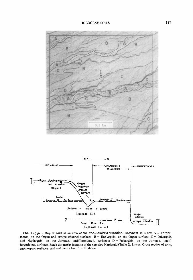
Soil position and morphology. The arid- semiarid transition is also characterized in many areas by soil-geomorphic relations that differ from those of the valley and the mountains. Stepped sequences of surfaces along the valley border and the mountain fronts present a fairly clear picture of soil- geomorphic relations because the soils are progressively older with increasing ele- vation of the steps, and specific kinds of soils occur on specific surfaces. Between the valley and the mountains, however, is a terrain in which these relations often do not hold. In some of these terrains, soils of a low surface are older than soils of an adjacent higher surface. In others, soils that differ greatly in age occur at the same elevation. An area illustrating both of these situations is shown in a soil map (Fig. 3). Precipitation is thought to be about 25 cm annually as compared to 20 cm at lower elevations westward.
Two levels may be seen looking north from the arroyo (at II, Fig. 3), with the lowermost appearing to be a younger terrace as along the valley border and mountain fronts. Here, however, the chronological relationships are reversed and the higher of the two surfaces is the younger: the topographic high is the Organ surface and its Holocene sediments have buried a sur- face and soil of late-Pleistocene age.
Holocene Haplargids also occur just south of the arroyo (near II, Fig. 3), at the same elevation as the soils of late- Pleistocene age just north of the arroyo. In these situations, soil morphology is a useful tool in the identification of geo- morphic surfaces and their associated sedi- ments. Where the deposits are isolated and the stratigraphic relation to older deposits cannot be determined, the Holocene soils and surfaces can be identified by soil morphology because it differs markedly from the morphology of older soils. For example, the Haplargid of Pleistocene age at the cross section (Fig. 3) has a
HOLOCENE SOILS 117
1~~~~_1=.
Piedmont - slope alluvium
(Jornoda II )
? ------- -?-
Camp Rice Fm. ’ (Piedmont facies)
---KXRIORTHENTS
FIG. 3 Upper. Map of soils in an area of the arid-semiarid transition. Dominant soils are: A = Torrior- then&, on the Organ and arroyo channel surfaces; B = Haplargids, on the Organ surface; C = Paleargids and Haplargids, on the Jomada, undifferentiated, surfaces; D = Paleargids, on the Jomada, undif- ferentiated, surfaces. Black dot marks location of the sampled Haplargid (Table 2). Lower. Cross section of soils, geomorphic surfaces, and sediments from I to II above.

118 LELAND H. GILE
TABLE 2
LABORATORY DATA FOR AN ARIDISOL IN THE ARID-SEMIARID TRANSITION AND A MOLLISOL IN THE SEMIARID ZONE (RHYOLITE PARENT MATERIALS)
Particle size distribution (mm)a
Ho- rizon
Sand Silt Clay CaCO, Organic Depth 2-0.05 0.05-0.002 <0.002 >2 vol equivb carbonC (cm) (%I (%) (%I (%I m (%I
Transition: Typic Haplargid (Pinaleno, No. 1); elev. 4730 ft (1442 m)
A2 o-5 68 23 8 50 tr(s)d 0.18 Blt 5-18 67 22 11 50 W 0.28 B2t 18-30 65 20 15 65 tr(s) 0.30 B3t 30-51 68 19 13 65 tr(s) 0.23 Clca 51-71 72 19 9 65 2 0.11 C2ca 71-94 75 17 8 65 1 0.07 c3 94- 147 86 11 4 1 0.03 Btb 147- 178 45 21 34 1 0.11
Semiarid zone: Pachic Haplustoll (Santo Tomas, No. 2); elev. 5700 ft (1737 m)
C o-3 66 26 8 40 tr(s) 1.00 All 3-8 59 30 12 50 MS) 1.32 Al2 8-28 59 29 12 50 tr(s) 1.18 Al3 28-53 61 27 13 45 trW 0.81 A3 53-79 60 28 12 45 tr(s) 0.47 c 79- 104 64 25 11 50 tr 0.30
a Method 3A (Soil Conservation Service, 1972). Carbonate not removed. b Methods 6Elb, 6E2A. c Method 6Ala. d Trace, detected only by qualitative procedure (evolution of gas bubbles observed under binocular
microscope on addition of 6N H,SO,) more sensitive than quantitative procedure used.
Bt horizon that is redder than the Bt hori- zon of the Holocene Haplargid and has higher chroma (2.5YR 4/6, dry, vs 5YR 5/4); that has more silicate clay (commonly sandy clay loam texture vs sandy loam); and more carbonate (stage II-III vs stage I). Upper horizons of soils of Pleistocene age in the arid-semiarid transition also have more organic carbon (thought to be largely due to higher silicate clay values) resulting in an Ustollic, rather than a Typic Haplargid.
Haplargid of an Organ ridge and fan (Location I). Typic Haplargids occur on the Organ ridge (Fig. 3). The illustrative Pinaleno soil (Figs. 4 and 5) is very gravelly and has a thin A2 horizon, a Bt horizon, and a Cca horizon. Organic carbon values are quite low (Table 2) and, with sand/clay
ratios (Soil Survey Staff, in press) place this soil in the Typic subgroup of the Haplargids.
Horizons of silicate clay and carbonate (Table 2) are thicker and deeper than in Holocene soils of drier areas downslope. The base of the reddish-brown B horizon here is 51 cm, whereas its base in the drier areas is commonly at about 25 cm. This greater thickness and depth is at- tributed to higher precipitation. The hori- zons of carbonate and silicate clay are quite discrete and have little overlap (Table 2). This is a typical feature of Holocene soils formed in low-carbonate parent ma- terials in the arid zone and contrasts with soils of Pleistocene age, in which there is usually substantial overlap between the two accumulations.
Judging from the character of the C hori-

FIG. 4. Landscape, Haplargid on an Organ ridge sloping 4%. The Organ Mountains are in the back- ground. Vegetation consists of fluffgrass (Tridens pulchelhs). mesquite (Prosopis julifroru ), Mormon tea (Ephredra Torreyana), cholla (Opuntia spp .). snakeweed (Gutierrezia sarothrae), ratany (Kmrneria parvjfolin). and Condulia Iycioides.
FIG. 5. Profile of a Typic Haplargid (Pinaleno series). This soil is an Aridisol because it has an ochric (rather than a mollicl epipedon. Scale is in feet.
119

120 LELAND H. GILE
zon and of similar gravelly deposits in the present arroyo, much of the silicate clay and essentially all of the carbonate in this soil were probably derived from atmos- pheric additions. The gravelly desert pave- ment should help trap these fine components in the dustfall and precipitation. These factors and the Holocene age of this soil indicate that all horizons are within reach of wetting at the present time and are forming now. Thus silicate clay and car- bonate appear to be slowly accumulating in the Bt and Cca horizons, respectively, at the present time.
Although carbonate was not measurable in the A and B horizons by the quantita- tive procedure used (Table 2), a sensitive qualitative test reveals very slight amounts of carbonate. This is additional evidence that carbonate from the atmosphere is being added to the soil surface and is moving downward in the soil at the present time.
Silt is highest in upper horizons of this soil (Table 2) and this may reflect still another addition from dustfall and precipita- tion. Silt should move less readily in the soil than the clay and carbonate, and thus may be accumulating in upper horizons.
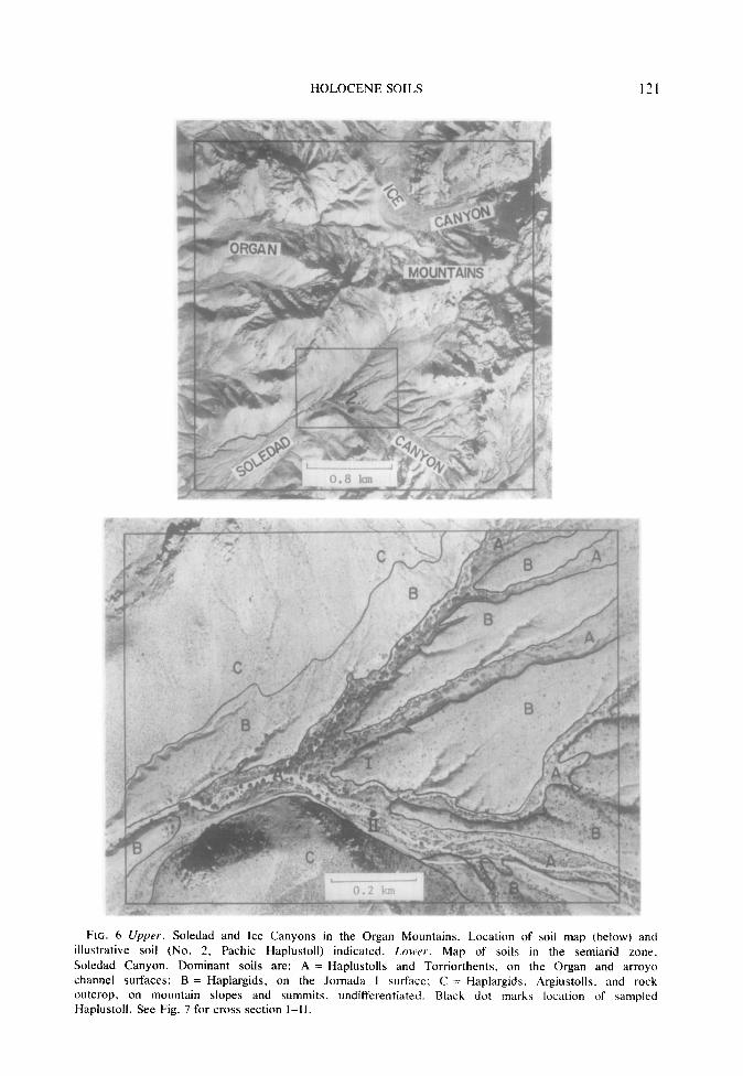
Soils of the Semiarid Zone
Distribution of soils in Soledad Canyon of the Organ Mountains is shown in a soil map (Fig. 6). The Holocene soils occur in narrow Organ terraces below the Pleistocene surfaces. Annual precipitation is thought to be about 35 cm.
Haplustoll of an Organ terrace (Loca- tion 2). Most of the Holocene soils have thick, dark A horizons. A Pachic Hap- lust011 (Figs. 6, 7, and 8) illustrates. Lab- oratory data are in Table 2. The consider- able thickness of the mollic epipedon (Table 2) appears to be due to slow accumula- tion of sediment during soil development. The soil is noncalcareous throughout, but very slight amounts of carbonate are found when a sensitive qualitative method is used (Table 2). It is thought that carbonate from the atmosphere is currently being
added to this soil. Because of higher precipitation, here, however, the car- bonate is more diffuse than at lower eleva- tions and some of it has probably moved to greater depths than in soils at lower elevations.
Soil and Geomorphic Associates of Pleistocene Age
The Holocene soils and geomorphic surfaces are associated with their analogs of various ages in the Pleistocene (Table 3). Terraces of different levels and ages are apparent in places along the mountain fronts. The terraces constitute a stepped sequence of geomorphic surfaces, with relative age relations similar to those along the valley border: the age of stable terraces and their soils increases with in- creasing elevation of the steps.
The general character of Pleistocene associates and the development of horizons of organic carbon, silicate clay, and car- bonate are well illustrated in alluvium derived from the southern part of the Organ Mountains. This is because there are large areas of parent materials derived from essentially one rock type (rhyolite), which occur in well-preserved fans and terraces of various ages in the mountain canyons and in the arid-semiarid transition.
Noncalcareous horizons in soils of Pleistocene age reflect precipitation in the arid-semiarid transition somewhat less clearly than the Holocene soils because textures are finer, leading to lower infiltra- tion rates and consequent higher runoff. Also, many soils of Pleistocene age have been truncated. Nevertheless, a non- calcareous zone does thicken mountain- ward in soils of stablest sites and of late- Pleistocene or late-Mid-Pleistocene age (Jornada II and I, respectively, Table 3.) The character of the arid-semiarid transi- tion at stable sites for soils of the Dona Ana surface is not known because no rem- nants of the Dona Ana surface have been found in the arid part of the study area.
HOLOCENE SOILS
FIG. 6 Upper. Soledad and Ice Canyons in the Organ Mountains. Location of soil map (below) and
illustrative soil (No. 2. Pachic Haplustoll) indicated. Lowr. Map of soils in the semiarid zone. Soledad Canyon. Dominant soils are: A = Haplustolls and Torriorthents. on the Organ and arroyo channel surfaces: B = Haplargids. on the Jornada I surface: C = Haplargids. Argiustolls, and rock outcrop, on mountain slopes and summits, undifferentiated. Black dot marks location of sampled Haplustoll. See Fig. 7 for cross section I-II.

122 LELAND H. GILE
N-S
t- HAPLARGIDS-
I\ fan alluvium
(Jornoda I)
Camp Rice Fm.
(pirdmont facies 1
URRIDRTHENT! - HAPLUGlDLLS - +TDRRl- DRTHENTG
\ \.
II
a&o olluvlum -----
FIG. 7. Cross section of soils, surfaces, and sediments from I-II, Fig. 6.
Soils of the semiarid zone illustrate the effect of greater precipitation on de- velopment of the stages of carbonate ac- cumulation (Gile et al., 1966; Table 3). For example, the soils of Jornada I, which have thick stage IV carbonate horizons in very gravelly materials of the valley border, have only stage I horizons (carbonate filaments and thin carbonate coatings on pebbles) in or underlying the thick Bt horizons in the mountain canyons. This carbonate is thought to be of Holocene age since it is morphologically similar to the carbonate of Holocene soils.
In the mountain canyons, most or all carbonate leached in Pleistocene pluvials must have moved out of the soils of Jornada I and II since they lack the prominent accumulations in soils of the same age downslope. However, the morphogenetic sequence (in gravelly materials) is com- pleted in the ancient soils of the Dona Ana surface (Table 3). Thus a much longer time is required for development of the various stages in the mountain canyons than along the Rio Grande Valley. This is at- tributed to greater precipitation in the mountains.
TABLE 3
ASPECTS OF THE GEOMORPHIC AND PEDOGENIC SETTING FOR HOLOCENE SOILS OF THE
MOUNTAIN CANYONS (RHYOLITE PARENT MATERIALS)
Age, years BP or epoch
Holocene (<7500) Late-Pleistocene Late Mid-Pleistocene Early Mid-Pleistocene(?)
Geo-
morphic surface
Organ Jornada II Jornada I Dona Ana
Illustrative subgroup
Pachic Haplustolls Ustollic Haplargids Ustollic Haplargids Petrocalcic Ustollic Paleargids
Stage of carbonate accumulation
(gravelly soils)
0 or I I I III, IV

HOLOCENE SOILS 123
FIG. 8 Upper. Landscape. Haplustoll on an Organ terrace sloping 7%. Organ terrace in fore- ground; Jornada I remnant on the next level, in middle ground; Organ Mountains on skyline. Vegetation in the vicinity consists of snakeweed, Apache plume (Fallugin paradoxa), cholla, tluffgrass. blue grama (Bouteloua gracilis), and sideoats grama (Bouteloua curtipenduh). Lorr,er. Profile of a Pachic Haplustoll (Santa Tomas series). This soil is Pachic because its mollic epipedon is more than 50 cm thick (Soil Survey Staff, in press). Scale is in feet.
The Pleistocene associates of Holocene is similar to that of the Holocene Mollisois. soils in the mountain canyons are commonly Usually, however, the epipedons do not Aridisols (Ustollic Haplargids) instead of qualify as mollic because their chromas Mollisols. Their content of organic carbon are too high. The high chroma Bt horizon
124
5400 1646
5 $i 5ooc
" 1524
f P
8 46OC 'Z 1402
E ;
420( 128(
LELAND H. GILE
Approximate precipitation, cm:
. 22 I
Approximate precipitation, cm:
b-23 - - 32+
I I I I 2 4 6
3.2 6.4 9.7 ,289
Miles Knl
FIG. 9. Relation of thickness of noncalcareous zone to increasing precipitation and elevation. All soils are of Holocene age and have formed in monzonite alluvium west of the San Agustin Mountains. Noncalcareous zone not to scale.
occurs at fairly shallow depths; this seems to have been caused by truncation of these ancient soils since a mollic epipedon has been preserved at stablest sites.
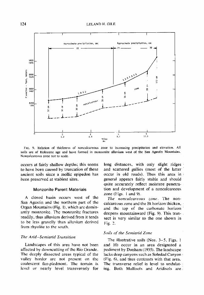
Monzonite Parent Materials
A closed basin occurs west of the San Agustin and the northern part of the Organ Mountains (Fig. l), which are domin- antly monzonite. The monzonite fractures readily, thus alluvium derived from it tends to be less gravelly than alluvium derived from rhyolite to the south.
The Arid-Semiarid Transition
Landscapes of this area have not been affected by downcutting of the Rio Grande. The deeply dissected areas typical of the valley border are not present on the coalescent fan-Piedmont. The terrain is level or nearly level transversely for
long distances, with only slight ridges and scattered gullies (most of the latter occur in old roads). Thus this area in general appears fairly stable and should quite accurately reflect moisture penetra- tion and development of a noncalcareous zone (Figs. 1 and 9).
The noncalcareous zone. The non- calcareous zone and the Bt horizon thicken, and the top of the carbonate horizon deepens mountainward (Fig. 9). This tran- sect is very similar to the one shown in Fig. 2.
Soils of the Semiarid Zone
The illustrative soils (Nos. 3-5, Figs. 1 and 10) occur in an area designated a pediment by Dunham (1935). The landscape lacks deep canyons such as Soledad Canyon (Fig. 6), and thus contrasts with that area. The transverse relief is level to undulat- ing. Both Mollisols and Aridisols are

HOLOCENE SOILS 13
FIG. IO. Location of San Agustin Mountains and Pass, town of Organ, U.S. Hwy. 70, soil map (Fig. 12). and illustrative soils. 3 = Torriorthentic Haplustoll (Aladdin series): 4 = Torriorthentic Haplustoll (Hawkeye series): 5 = Typic Haplargid (Sonoita series).
present. Because of extensive Organ de- posits, this area well illustrates the char- acter of the Mollisol-Aridisol transition in the semiarid zone. Nearly all of the Molli- sols in the illustrative area are of Holo- cene age because in most places the Organ surface is quite stable and level trans- versely, and the mollic epipedon is still pre- served. Commonly it has been truncated on all but the stablest soils of Pleistocene age. The Mollisols are dominated by the Torri- orthentic Haplustolls, Aladdin soils (coarse-loamy), with smaller areas of Hawkeye soils (sandy). Both illustrate the mollic epipedon in its incipient stages (Table 4). At stable sites, more organic carbon would occur in soils at higher eleva- tions and/or with more clay.
Haplustoll of an Organ fan (Loca- tion 3). The illustrative soil is a Torriorthen- tic Haplustoll (Aladdin, Fig. 11: Table 4). The A horizon is thick and noncalcareous. The thickness is thought to be largely the result of episodic sedimentation, with intervals of stability during which an A horizon formed. The area is directly down- slope from steep bedrock of the San Agustin Mountains, and is in the path of main drainage lines from these mountains. It is therefore in a position favoring the ac- cumulation of sediment. Other factors may favor development of these thick A hori- zons. The soils are highly pervious and a given increment of precipitation should cause relatively deep wetting. This may contribute to the thickness of the zone
126 LELAND H. GILE
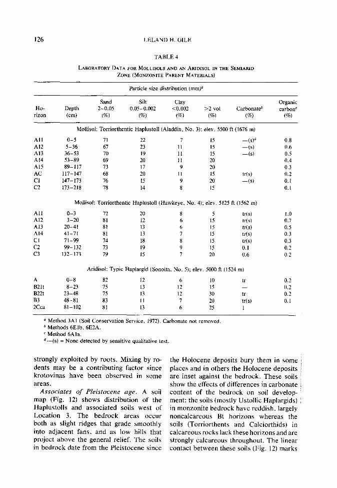
TABLE 4
LABORATORY DATA FOR MOLLBOLS AND AN ARIDISOL IN THE SEMIARID ZONE (MONZONITE PARENT MATERIALS)
Particle size distribution (mm)
Ho- Depth rizon (cm)
Sand Silt Clay 2-0.05 0.05-0.002 <0.002
(%I (%I (%) >2 vol Carbonate*
(%) cm
Organic carbonc
(%)
All o-5 71 22 7 15 Al2 5-36 67 23 11 15 Al3 36-53 70 19 11 15 Al4 53-89 69 20 11 20 Al5 89-117 73 17 9 20 AC 117-147 68 20 11 15 Cl l47- 173 76 15 9 20 c2 173-218 78 14 8 15
-w -(s) 4s)
tr(s) 4s)
0.8 0.6 0.5 0.4 0.3 0.2 0.1 0.1
Mollisol: Torriorthentic Haplustoll (Hawkeye, No. 4); elev. 5125 ft (1562 m)
All o-3 72 20 8 5 tr(s) 1.0 Al2 3-20 81 12 6 15 MS) 0.7 Al3 20-41 81 13 6 15 Ws) 0.5 Al4 41-71 81 13 7 15 tr(s) 0.3 Cl 71-99 74 18 8 15 W(s) 0.3 c2 99-132 73 19 9 15 0.1 0.2 c3 l32- 173 79 15 7 20 0.6 0.2
Aridisol: Typic Haplargid (Sonoita, No. 5); elev. 5000 ft (1524 m)
A B2lt B22t B3 2Cca
O-8 8-23
23-48 48-81 81-102
82 75 75 83 81
12 13 13 11 13
6 12 12 7 6
IO 15 30 20 25
tr - tr Ws) 1
0.2 0.2 0.2 0.1
Mollisol: Torriorthentic Haplustoll (Aladdin, No. 3); elev. 5500 ft (1676 m)
(2 Method 3Al (Soil Conservation Service, 1972). Carbonate not removed. b Methods 6Elb, 6E2A. c Method 6Ala. d-(s) = None detected by sensitive qualitative test.
strongly exploited by roots. Mixing by ro- dents may be a contributing factor since krotovinas have been observed in some areas.
Associates of Pleistocene age. A soil map (Fig. 12) shows distribution of the Haplustolls and associated soils west of Location 3. The bedrock areas occur both as slight ridges that grade smoothly into adjacent fans, and as low hills that project above the general relief. The soils in bedrock date from the Pleistocene since
the Holocene deposits bury them in some i places and in others the Holocene deposits / are inset against the bedrock. These soils i show the effects of differences in carbonate : content of the bedrock on soil develop- ment: the soils (mostly Ustollic Haplargids) in monzonite bedrock have reddish, largely noncalcareous Bt horizons whereas the soils (Torriorthents and Calciorthids) in calcareous rocks lack these horizons and are strongly calcareous throughout. The linear contact between these soils (Fig. 12) marks

HOLOCENE SOILS 137
FIG. 11 Upper. Landscape, Haplustoll (No. 3, Fig. 10) on an Organ fan sloping 8%. View is to the south. The Organ Mountains are on the skyline; the Organ surface is in the foreground and middle ground. Vegetation consists of snakeweed, Yucca elata, prickly pear, (Opuntia spp.). fluffgrass. sumac (Rhus microphylla), a few clumps of blue grama. and a few cholla. Louver. Profile of a Torriorthentic Haplustoll (Aladdin series). Scale is in feet.
a fault between sedimentary rocks (lime- map (Fig. 12). Most of these, where present. stone and shale) and quartz monzonite are buried beneath the Holocene deposits. (Dunham, 1935). Haplustoll of an Organ fan and drainagr-
Few soils in Pleistocene alluvium have way (Location 4). This soil (Hawkeye, Fig. been observed in the area shown in the soil 12, Table 4) is similar to Aladdin but is

128 LELAND H. GILE
FIG. 12. Map of soils in the semiarid zone, downslope from the San Agustin Mountains. Dominant soils are: A = Torriorthents on the arroyo channel surface: B = Haplustolls (sandy) on the Organ surface; C = Haplustolls (coarse-loamy) on the Organ surface; D = Haplargids, on the Organ surface; E = Haplargids and rock outcrop, on Jornada pediment surfaces and mountain slopes and summits, undifferenti- ated; F = Toniorthents and Calciorthids, on Jomada pediment surfaces and mountain slopes and summits, undifferentiated. Black dot marks location of sampled HaplustoJL
in the sandy particle-size class instead of coarse-loamy. Hawkeye soils tend to occur in younger, lower portions of the landscape such as the general topographic low at this site, and in areas where tex- tures of Organ alluvium are particularly coarse. Slope is 5%. Vegetation is snake- weed, Yucca data, mesquite, Mormon tea, fluffgrass, and cholla.
Haplargid of an Organ ridge (Location 5). Most of the Holocene Aridisols are Typic Haplargids; these tend to occur mainly on narrow ridges where there has
been some soil truncation. Ustollic Haplar- gids are most common in older soils be- cause they are usually more clayey and tend to have more organic carbon.
A Sonoita soil illustrates the Typic 1 Haplargids (Table 4). This soil is at about the same elevation as Haplustolls north- ward but it has a Bt horizon and lacks the thick dark A horizons. Organic carbon is substantially less than in the Haplustolls (Table 4). A possible reason for absence of a thick, dark A horizon in Sonoita is its location on a slight ridge that could not

HOLOCENE SOILS 129
FIG. 13. Block diagram showing Holocene and Pleistocene fans just west of Lohman Canyon (No. 6, Fig. 1). The Holocene fan is dominated by Haplustolls and the Pleistocene fan is dominated by Paleorthids. Lower slopes of the San Andres Mountains shown at right. A small bedrock outlier is in the center. 1 = approximate location of the sampled Haplustoll (Table 5).
have been accessible to sedimentation for zone downslope. This is attributed to higher some time. The evidence suggests that while elevation and precipitation. Bt horizons were forming in Sonoita soils, sediments were still accumulating at the sur- SOILS FORMED IN HIGH-CARBONATE face of Aladdin and Hawkeye soils. PARENT MATERIALS
The Bt horizon is thicker and the Cca These materials occur west of the San horizon is deeper than in soils of the arid Andres Mountains. The arid-semiarid
TABLE 5
LABORATORY DATA FOR A MOLLISOL IN THE SEMIARID ZONE (HIGH-CARBONATE PARENT MATERIALS)
Particle size distribution (mm)a
Ho- rizon
Depth (cm)
Sand 2-0.05
(%I
Silt 0.05-0.002
(%)
Clay <0.002
(%) >2 vol
(%I
Carbonate (mm)*
>2 <2 (%I (%)
Organic carbon’
m’c) -
Pachic Haplustoll (Aladdin variant, No. 6); elev. 5200 ft (1585 m)
Allca O-20 73 19 8 10 50 7 0.8 A12ca 20-48 69 21 10 25 22 9 0.7 A13ca 48-76 70 20 10 20 28 10 0.7 Clca 76- 102 68 22 IO 20 20 11 0.4 C2ca 102- 124 74 17 9 35 20 12 0.3
a Treated by method lB3 (Soil Conservation Service, 1972) to remove carbonate, but much carbonate (in the form of limestone pebbles) remained.
b Carbonate for whole material and <2 mm used to calculate carbonate in >2 mm. <2 mm by method 6Ela. ’ Method 6Ala.

130 LELAND H. GILE
transition is not illustrated by a noncal- careous zone; all soils are highly calcareous throughout because of the high carbonate content of these materials.
Soils Of The Semiarid Zone
The illustrative Haplustoll (Aladdin variant) occurs just west of Lohman Canyon (Figs. 1 and 13). (For an air view of Lohman Canyon and adjacent areas, refer to Gile and Hawley, 1968.) Below narrow canyons such as this, Holocene deposits often bury older deposits and their soils instead of being inset against them (Fig. 13).
Laboratory data are in Table 5. This Haplustoll has stage I carbonate as thin coatings on sand grains and pebbles. Allogenic carbonate occurs throughout be- cause of the highly calcareous parent ma- terials. There are admixtures of igneous rocks, however, and for this reason the carbonate contents are not extremely high (Table 5). The presence of carbonate in these soils shows that Holocene precipita- tion has not been sufficient to remove it. However, a few, small stable areas of soils preserved on the Jornada surface down- slope (Fig. 13) have reddish-brown Bt horizons that in places are noncalcareous in part. These relations indicate that the greater moisture of a Pleistocene pluvial was sufficient to leach carbonates from upper horizons and to develop a Bt horizon. But even in soils of Pleistocene age, the reddish- brown Bt horizons have not formed where additions from igneous rocks are absent and carbonate contents of the parent materials are extremely high.
CONCLUSIONS
Holocene soils of the semiarid area in southern New Mexico occur on terraces, ridges, fans, and drainageways in and adja- cent to the mountains. The illustrative soils have formed in alluvium derived primarily from rhyolite, monzonite, and
sedimentary rocks, mainly limestone. Cal- cium carbonate from dustfall and precipita- tion has been added to all soils during their development and silicate clay has been added to some soils.
A large arid basin and a river valley occur downslope from the mountains. The arid-semiarid transition is marked by an increase in precipitation, thickening and darkening of A horizons, an increase in depth of wetting, and a change in vegeta- tion.
Soils formed in low-carbonate parent materials show additional changes moun- tainward. These changes are best shown by soils of stable landscapes and with moderately coarse textures. Soil moisture in the arid basin is sufficient to move carbonate from the surface into the soil and to form a surhcial noncalcareous zone with a carbonate horizon beneath it. Thickness of the noncalcareous zone gradually increases mountainward, reflect- ing the increase in precipitation. As this happens, the horizon of silicate clay ac- cumulation also thickens and the top of the carbonate horizon deepens. In Holo- cene soils the horizon of silicate clay accumulation is just above or extends slightly into the carbonate horizon. This horizon arrangement suggests illuviation: clay would move downward in suspension and accumulate in a zone that is wetted frequently during the rainy season. Bicar- bonate in solution would move deeper than the clay and precipitate below it as the soil solution dries. This horizon arrange- ment persists with increasing precipitation and is additional evidence that illuviation is a major factor in the development of both silicate clay and carbonate horizons.
In sandy loam and sandy textures the two horizons tend to diverge at highest elevations, where some Bt horizons are not underlain by a carbonate horizon. Ap- parently the carbonates were moved to substantial depths by occasional very deep wettings. However, stage I carbonate horizons have been observed in textures of

HOLOCENE SOILS 131
sandy clay loam. This suggests that the finer textures may retard downward movement of soil moisture, resulting in the horizon of carbonate accumulation.
A noncalcareous zone and a reddish- brown Bt horizon have not developed in soils formed in high-carbonate parent ma- terials. In places, however, adjacent soils of Pleistocene age do have a noncalcareous, reddish-brown Bt horizon if the parent materials have additions from noncal- careous rocks. This must reflect the greater effective moisture of Pleistocene pluvials in leaching carbonate and developing the reddish brown Bt horizon.
Nearly all Holocene soils in the arid basin and valley are Aridisols or Entisols; Mollisols do not occur in soils of any age. In the semiarid mountains, however, most Holocene soils are Mollisols with thick, dark A horizons. The substantial thick- ness of these horizons is attributed primarily to episodes of sedimentation during soil development.
The Aridisol-Mollisol transition occurs in several ways. One involves Holocene soils of stable sites in which the landscape is level or nearly level transversely. Organic carbon gradually increases and color darkens with increasing elevation; finally the Holocene Aridisols change to Holo- cene Mollisols. In another kind of Aridisol- Mollisol transition, Holocene Aridisols occur on narrow ridges well within the semi- arid zone. On these narrow ridges the mollic epipedon has been truncated or did not form. Laterally the Holocene Aridisols change abruptly to Holocene Mollisols on adjacent terraces that are level trans- versely.
Another Aridisol-Mollisol transition in- volves Holocene soils and soils of Pleisto- cene age. In these cases, soils of Pleisto- cene fans have been truncated and Bt hori- zons with chromas too high for a mollic epipedon are at shallow depth. These soils are Ustollic Haplargids, which are intergrades to the Mollisols. Low, stable terraces with Holocene Mollisols are
inset against the higher Pleistocene fans. This results in an abrupt boundary between Holocene Mollisols and Aridisols of Pleistocene age.
The arid-semiarid transition is also characterized in many places by soil- geomorphic relations that differ from those of the valley and the mountains. Stepped sequences of surfaces along the valley border and mountain fronts present a fairly clear picture of soil-geomorphic relations because the soils are progressively older with increasing elevation of the steps, and specific kinds of soils occur on specific sur- faces. Between the valley and the moun- tains, however, is a terrain in which these relations often do not hold. In some of these areas, a lower terrace and its soils are older instead of younger than adjacent higher ones. In others, soils that differ greatly in age occur at the same eleva- tion. In still other situations, deposits are isolated and their stratigraphic relation to other deposits cannot be demonstrated. In these cases soil morphology may be used to distinguish the Holocene soils and surfaces from their older analogs if the morphological range of the various soils has been determined. For example, in an illustrative area the Bt horizons of Holocene Haplargids are no redder than 5YR; chromas are no higher than 4; textures are no heavier than sandy loam; and the stage of carbonate accumulation is no more than I.
Soils and surfaces of Pleistocene age are important associates of their Holocene analogs in the semiarid zone. Soils of both ages illustrate the effect of a semiarid vs arid climate on development of the stages of carbonate accumulation and completion of the gravelly sequence (stages I-IV). In the arid zone downslope, soils of late mid- Pleistocene age have stage IV carbonate horizons in very gravelly materials. Soils of the same age in the semiarid moun- tain canyons have only stage I horizons. This carbonate is thought to be of Holo- cene age because it is morphologically

132 LELAND H. GILE
similar to the carbonate of Holocene soils, and because it occurs in similar textures and at similar depths. Most or all carbonate leached in Pleistocene pluvials must have moved out of the soils of Pleistocene age since they lack the promi- nent accumulations in soils of the same age in the arid zone downslope. However, the sequence of carbonate accumulation in gravelly materials is completed in ancient soils that are thought to date from early mid-Pleistocene. Thus a longer time is re- quired for completion of the carbonate sequence in the semiarid mountain canyons than in the arid zone downslope. This is attributed to higher precipitation in the mountains.
ACKNOWLEDGMENTS
Laboratory analyses were made by the Lincoln Soil Survey Laboratory, Lincoln, Nebraska. Acknowl- edgment is made to Mr. Sam Horn for drawing the block diagram and to Mr. Mark Cower for pre- paring the cross sections.
REFERENCES
Dunham, K. C. (1935). The geology of the Organ Mountains with an account of the geology and mineral resources of Dona Ana County, New Mexico. New Mexico Bureau of Mines and Mineral Resources Bulletin 11. Socorro, New Mexico.
Gile, L. H. (1975). Holocene soils and soil-geo- morphic relations in an arid region of southern New Mexico, Quaternary Research 5, 321-360.
Gile, L. H., and Hawley, J. W. (1968). Age and comparative development of desert soils at the Gardner Spring Radiocarbon Site, New Mexico. Soil Science Society of America Proceedings 32, 709-716.
Gile, L. H., Hawley, J. W., and Grossman, R. B. (1970). Distribution and genesis of soils and geomorphic surfaces in a desert region of southern New Mexico. Guidebook, Soil-Geomorphology Field Conference, Soil Science Soctety of Amer- ica, University Park.
Gile, L. H., Peterson, F. F., and Grossman, R. B. (1%6) Morphological and genetic sequences of carbonate accumulation in desert soils. Soil Science 101, 347-360.
Hawley, J. W., and Kottlowski, F. E. (1969). Quatemary geology of the south-central New Mexico border region. In “Border Stratigraphy Symposium” (F. E. Kottlowski and D.V. LeMone, Eds.), pp. 89- 115. New Mexico Institute of Mining and Technology, State Bureau of Mines and Mineral Resources Circular 104, Socorro, New Mexico.
Ruhe, R. V. (1964). Landscape morphology and alluvial deposits in southern New Mexico. Annals of the Association of American Geographers 54, 147- 159.
Ruhe, R. V. (1967). Geomorphic surfaces and surlicial deposits in southern New Mexico. New Mexico Bureau of Mines and Mineral Resources Memoir 18. Socorro, New Mexico.
Soil Conservation Service (1972). Soil survey labora- tory methods and procedures for collecting soil samples. Soil Survey Investigations Report No. 1. Washington, D. C.
Soil Science Society of America. (1975). “Glossary of Soil Science Terms.” Soil Science Society of America, Madison, Wisconsin.
Soil Survey Staff. “Soil Taxonomy, a Basic System of Soil Classification For Making and Interpret- ing Soil Surveys.” Soil Conservation Service, United States Department of Agriculture, Washington, D. C., in press.
Thorp, J., Strong, L. E., and Gamble, E. E. (1957). Experiments in soil genesis-the role of leaching. Soil Science Society of America Proceedings 21, 99- 102.
Thorn, J., Cady, J. G., and Gamble, E. E. (1959). Genesis of Miami silt loam. Soil Science Socihty of America Proceedings 23, 156- 161.