hochzeiger sommerpanorama 2010
DESCRIPTION
Hochzeiger Sommerpanorama 2010-2011, WandertippsTRANSCRIPT
P
OG
G ON PN
NG
A B C D
C D
D
B
B
B
C
C
D
DD
E
E
E
G
G H
II
I
J
JJ
J
J
J
K
K
K
K
K
L
LL
L
L
L
MM
M
M
M
MC
N
N
N
O P
F
F
F
F
E G
Landschaftsteich
Landschaftsteich
MITTELSTATION2.000 m
TALSTATION1.450 m
TANZALM
STALDER-HÜTTE
HOCHZEIGERHAUS
KALBENALM
zur Erlanger Hütte
KAITANGER
JERZENS
Kinderspiel-platz
Kletter-park
Abenteuerpark
LISS
360° Rundblick
Zirbenweg
SECHSZEIGER2.395 m
MURMENTENKAR2.770 m
BRECHKOGEL2.936 m
WILDGRAT2.971 m
HOCHZEIGER2.560 m
ZOLLBERG2.225 m
RIEGETALLandschaftsschutzgebiet
RIEGESPITZE2.944 m
KARKOPF2.686 m
zur Ludwigsburger Hütte
GEMEINDE-KOPF
2.771 m
LEINER ALM
Groaßsee
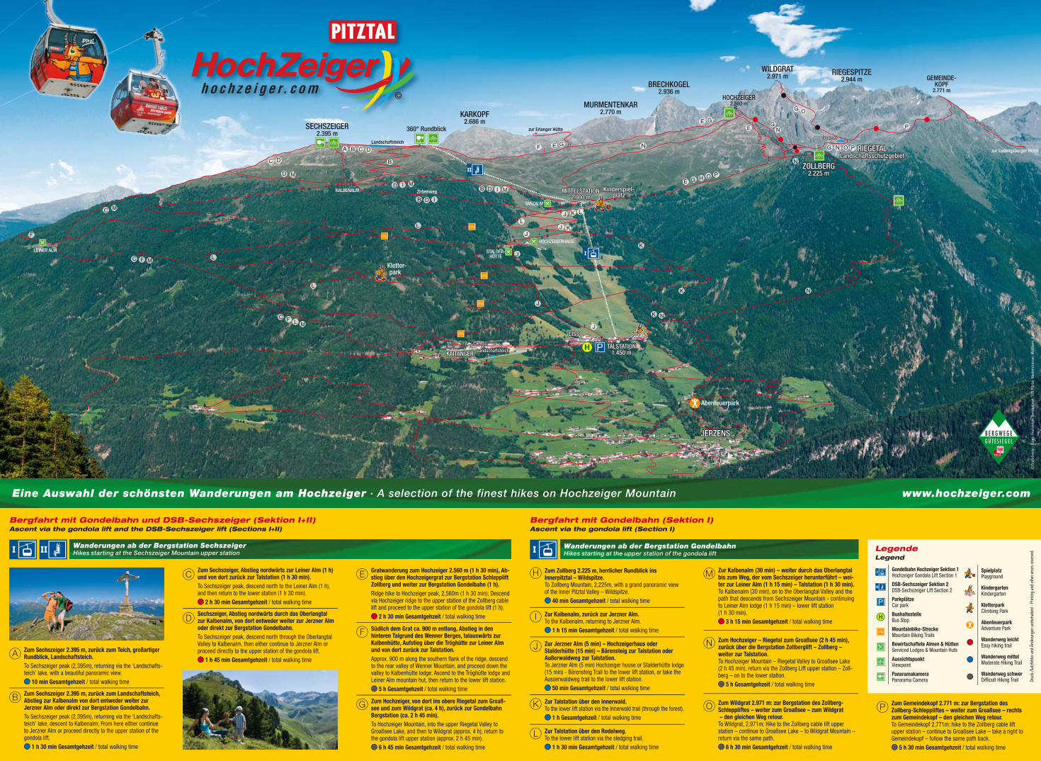
Eine Auswahl der schönsten Wanderungen am Hochzeiger · A selection of the finest hikes on Hochzeiger Mountain www.hochzeiger.com
A Zum Sechszeiger 2.395 m, zurück zum Teich, großartiger Rundblick, Landschaftsteich.To Sechszeiger peak (2,395m), returning via the ‘Landschafts-teich’ lake, with a beautiful panoramic view.
10 min Gesamtgehzeit / total walking time
B Zum Sechszeiger 2.395 m, zurück zum Landschaftsteich, Abstieg zur Kalbenalm von dort entweder weiter zur Jerzner Alm oder direkt zur Bergstation Gondelbahn. To Sechszeiger peak (2,395m), returning via the ‘Landschafts-teich’ lake, descent to Kalbenalm; From here either continue to Jerzner Alm or proceed directly to the upper station of the gondola lift.
1 h 30 min Gesamtgehzeit / total walking time
CZum Sechszeiger, Abstieg nordwärts zur Leiner Alm (1 h) und von dort zurück zur Talstation (1 h 30 min). To Sechszeiger peak, descend north to the Leiner Alm (1 h), and then return to the lower station (1 h 30 min).
2 h 30 min Gesamtgehzeit / total walking time
DSechszeiger, Abstieg nordwärts durch das Oberlangtal zur Kalbenalm, von dort entweder weiter zur Jerzner Alm oder direkt zur Bergstation Gondelbahn.To Sechszeiger peak, descend north through the Oberlangtal Valley to Kalbenalm, then either continue to Jerzner Alm or proceed directly to the upper station of the gondola lift.
1 h 45 min Gesamtgehzeit / total walking time
E Gratwanderung zum Hochzeiger 2.560 m (1 h 30 min), Ab-stieg über den Hochzeigergrat zur Bergstation Schlepplift Zollberg und weiter zur Bergstation Gondelbahn (1 h).Ridge hike to Hochzeiger peak, 2,560m (1 h 30 min); Descend via Hochzeiger ridge to the upper station of the Zollberg cable lift and proceed to the upper station of the gondola lift (1 h).
2 h 30 min Gesamtgehzeit / total walking time
F Südlich dem Grat ca. 900 m entlang, Abstieg in den hinteren Talgrund des Wenner Berges, talauswärts zur Kalbenhütte, Aufstieg über die Tröghütte zur Leiner Alm und von dort zurück zur Talstation. Approx. 900 m along the southern fl ank of the ridge, descend to the rear valley of Wenner Mountain, and proceed down the valley to Kalbenhütte lodge; Ascend to the Tröghütte lodge and Leiner Alm mountain hut, then return to the lower lift station.
5 h Gesamtgehzeit / total walking time
G Zum Hochzeiger, von dort ins obere Riegetal zum Groaß-see und zum Wildgrat (ca. 4 h), zurück zur Gondelbahn Bergstation (ca. 2 h 45 min).To Hochzeiger Mountain, into the upper Riegetal Valley to Groaßsee Lake, and then to Wildgrat (approx. 4 h); return to the gondola lift upper station (approx. 2 h 45 min).
6 h 45 min Gesamtgehzeit / total walking time
Bergfahrt mit Gondelbahn und DSB-Sechszeiger (Sektion I+II) Ascent via the gondola lift and the DSB-Sechszeiger lift (Sections I+II)
Gondelbahn Hochzeiger Sektion 1 Hochzeiger Gondola Lift Section 1
DSB-Sechszeiger Sektion 2DSB-Sechszeiger Lift Section 2
Parkplätze Car park
BushaltestelleBus Stop
Mountainbike-StreckeMountain Biking Trails
Bewirtschaftete Almen & HüttenServiced Lodges & Mountain Huts
AussichtspunktViewpoint
PanoramakameraPanorama Camera
SpielplatzPlayground
KindergartenKindergarten
KletterparkClimbing Park
AbenteuerparkAdventure Park
Wanderweg leichtEasy hiking trail
Wanderweg mittelModerate Hiking Trail
Wanderweg schwerDiffi cult Hiking Trail
Legende Legend
H Zum Zollberg 2.225 m, herrlicher Rundblick ins Innerpitztal – Wildspitze.To Zollberg Mountain, 2,225m, with a grand panoramic view of the inner Pitztal Valley – Wildspitze.
40 min Gesamtgehzeit / total walking time
I Zur Kalbenalm, zurück zur Jerzner Alm. To the Kalbenalm, returning to Jerzner Alm.
1 h 15 min Gesamtgehzeit / total walking time
J Zur Jerzner Alm (5 min) – Hochzeigerhaus oder Stalderhütte (15 min) – Bärensteig zur Talstation oder Außerwaldweg zur Talstation. To Jerzner Alm (5 min) Hochzeiger house or Stalderhütte lodge (15 min) - Bärensteig Trail to the lower lift station, or take the Ausserwaldweg trail to the lower lift station.
50 min Gesamtgehzeit / total walking time
K Zur Talstation über den Innerwald.To the lower lift station via the Innerwald trail (through the forest).
1 h Gesamtgehzeit / total walking time
L Zur Talstation über den Rodelweg.To the lower lift station via the sledging trail.
1 h 30 min Gesamtgehzeit / total walking time
M Zur Kalbenalm (30 min) – weiter durch das Oberlangtal bis zum Weg, der vom Sechszeiger herunterführt – wei-ter zur Leiner Alm (1 h 15 min) – Talstation (1 h 30 min). To Kalbenalm (30 min), on to the Oberlangtal Valley and the path that descends from Sechszeiger Mountain - continuing to Leiner Alm lodge (1 h 15 min) – lower lift station (1 h 30 min).
3 h 15 min Gesamtgehzeit / total walking time
N Zum Hochzeiger – Riegetal zum Groaßsee (2 h 45 min), zurück über die Bergstation Zollberglift – Zollberg – weiter zur Talstation.To Hochzeiger Mountain – Riegetal Valley to Groaßsee Lake (2 h 45 min), return via the Zollberg Lift upper station – Zoll-berg – on to the lower station.
5 h Gesamtgehzeit / total walking time
O Zum Wildgrat 2.971 m: zur Bergstation des Zollberg- Schleppliftes – weiter zum Groaßsee – zum Wildgrat – den gleichen Weg retour. To Wildgrat, 2,971m: Hike to the Zollberg cable lift upper station – continue to Groaßsee Lake – to Wildgrat Mountain – return via the same path.
6 h 30 min Gesamtgehzeit / total walking time
P Zum Gemeindekopf 2.771 m: zur Bergstation des Zollberg-Schleppliftes – weiter zum Groaßsee – rechts zum Gemeindekopf – den gleichen Weg retour.To Gemeindekopf 2,771m: hike to the Zollberg cable lift upper station – continue to Groaßsee Lake – take a right to Gemeindekopf – follow the same path back.
5 h 30 min Gesamtgehzeit / total walking time
Bergfahrt mit Gondelbahn (Sektion I) Ascent via the gondola lift (Section I)
Wanderungen ab der Bergstation GondelbahnHikes starting at the upper station of the gondola lift
Wanderungen ab der Bergstation SechszeigerHikes starting at the Sechszeiger Mountain upper station
© G
rafo
tron
ic •
Fot
os: H
ochz
eige
r Ber
gbah
nen,
TVB
Pitz
tal,
Nied
erst
rass
er, W
idm
ann,
Aue
rDr
uck-
/Sat
zfehl
er u
nd Ä
nder
unge
n vo
rbeh
alte
n! ·
Prin
ting
and
othe
r erro
rs re
serv
ed.