history tours in and around canberra - open research: open … · · 2017-12-15wigmore, canberra,...
TRANSCRIPT
History tours in and around CanberraJill W aterhouse
This book was published by ANU Press between 1965–1991.
This republication is part of the digitisation project being carried out by Scholarly Information Services/Library and ANU Press.
This project aims to make past scholarly works published by The Australian National University available to
a global audience under its open-access policy.

History tours in and around Canberra
Jill Waterhouse
A ustralian N ational University Press C anberra, A ustralia, London, UK and T rum bull,

First published in A ustralia 1980
Printed in A ustralia for the A ustralian National University Press, C anberra
© Jill W aterhouse 1980
This book is copyright. A part from any fair dealing for the purpose of private study, research, criticism, or review, as perm itted under the Copyright Act, no part may be reproduced by any process w ithout w ritten permission. Inquiries should be m ade to the publisher.
N ational L ibrary of A ustralia Cataloguing-in-Publication entry
W aterhouse, D iana Jill.History tours in and around C anberra.
(C anberra companions)ISBN 0 7081 1943 3
1. A ustralian Capital T erritory — Description and travel — Guide-books. I. T itle . (Series)
919.47
Library of Congress No. 79-55792
Photographs by Doug Jervis
United K ingdom , Europe, M iddle East, and A fr ica : Books A ustralia ,3 H enrietta St, London WC2E 8LU, England N orth A m erica: Books A ustralia, T rum bull, C onn., USA Southeast A s ia : Angus & Robertson (S.E.Asia) Pty Ltd, Singapore
J a p a n : U nited Publishers Services L td, Tokyo
Cover: Inside the slab shed at B lundell’s cottage

Contents
Acknowledgments and Sources ivPreparing for a History T our 1C anberra’s History:
Ten Basic Questions Answered 3Rude Huts and Undressed Stone 10Exploring Cemeteries 21Nineteenth and Twentieth
Century Canberra 24Tours from the Federal Highway 51Tours from the King’s Highway 65Tours from the Barton Highway 74Tours from the Monaro Highway 85Tours from the C aptain’s Flat Road 89
iii
Acknowledgments and Sources
Many local residents, particularly Pat W ardle, Lyall Gillespie, Bert Sheedy, Michael Comans and my family of C anberra, H eather H ubbard and Greg Nye of Bungendore and David Gilbert of C ap tain ’s Flat were generous with their time and advice. Doug Jervis was not only willing to take photographs at the drop of a hat but also had them developed within the day. Barbara Hutchinson typed the chapters with similar speed and enthusiasm. The maps and drawings are the work of B. Payne, R. G. Cope, J. M. M acDonald, M. T . Mitchell a n d j. Nikoleski.
The files and publications of the C anberra and District Historical Society including the Canberra Historical
Journal and the Newsletter are gratefully acknowledged and warmly recommended. In the N ational Library, C anberra, the M cLaren Local History Collection is a good starting point for the researcher. O ther useful reference works include Samuel Shumack, Tales and Legends o f Canberra Pioneers, reprinted by ANU Press as a Canberra Companion in 1977, Alan Fitzgerald, Historic Canberra 1825-1945 (1977), L. Fitzhardinge, St J o h n ’s Church and Canberra (1941), E. Lea-Scarlett, Queanbeyan (1968), and Gundaroo (1972), L. W igmore, Canberra, History o f A ustralia’s National Capital (1971), and L. Gilbert, W. P. Driscoll a n d j . A. Sutherland, History Around Us, A n Enquiry Approach to Local History (1974).
iv

Preparing for a History Tour
A friend of mine who once went on a history tour almost fainted with boredom. ‘Who cares’, she cried to the tour leader who was busily discoursing on the merits of a four- poster bed, ‘how many pieces of wood went into m aking this bedstead?’
This book is offered as smelling salts for those who feel weak at the thought of having to trail behind a guide or who need convincing that Canberra and the surrounding districts have a visible past. Most of the tours described can be enjoyed without getting out of the car. But for those who want to explore old houses, churches and graveyards, who would like to understand the district’s pattern of development and who hope to make discoveries of their own, here are a few hints on preparation.1. a) Buy the latest Canberra street m ap from any newsagent or garage.
b) O btain a Topographic Survey Map. Do not shiver at the thought! Survey maps are often m uch more interesting than street maps. The most im portant m ap is Canberra, Sheet 8727, Edition I, Series R 651. This may be supplemented by the adjoining maps of Yass 8628, Gunning 8728, Goulbum 8828, Braidwood 8827, Araluen 8826, and Michelago 8726. The Australian Capital Territory as a whole is shown on N atm ap 1:100 000, Edition 2, 1976.
The maps may be bought from the Australian Governm ent Publishing Service Bookshop, 70 Alinga Street, City Centre, telephone 47 7211.2. Taking the maps with you, go to the lookouts on Mt Ainslie, Black M ountain and Red Hill to see the general lie of the land.
1
3. Read the chapter of this book on identifying architectural styles then add your own examples as you travel.4. To make a survey of a street or a scattergram of a graveyard, you will need paper with a firm backing, a pencil and rubber, a tape-m easure and string, chalk for highlighting worn lettering on headstones, a crayon for taking rubbings and a cam era.5. Do not ‘souvenir’ items from any site. Take a rubbing or a photograph instead.6. All the places in this book are, at the time of publication, accessible to (if not always open to) the public. Always ask permission before entering private property. Close all gates.7. W A R N I N G : Observe normal safety precautions, especially if a building, tombstone or mining shaft looks insecure. No responsibility is accepted for damage, injuries, inconvenience or untow ard events arising out of the use of the inform ation given in this book.
Only readily accessible buildings and clearly marked sites, showing more than a tree or a few rocks, have been m entioned in this book. Hundreds of other places deserve consideration, among them Duntroon Woolshed, W oden homestead, a school site and part of an old stone wall at Tuggeranong, Haig Park and the sites of the Cricketers Arms Hotel, the Causeway Hall and the Civic police stations. Some of these are on private property but the Canberra and District Historical Society and the D epartm ent of the Capital Territory may be able to help the serious researcher.
Anyone who embarks on a history tour in or around Canberra can make a worthwhile contribution to the records of the past simply by pinpointing all the places visited on a m ap (there is, as yet, no m ap of Historic C anberra) and by m aking notes of structures, particularly those under threat of demolition. As W alter Burley Griffin wrote, ‘In the future, as sure as fate, our purposes, our strength, our insincerities, our foibles will be an open book in the rem ains or ruins of our buildings.’
2

Canberra’s History: Ten Basic Questions Answered
1. What was Canberra called in the nineteenth century and when did it become known by its present name?T he first maps show the name Limestone Plains, referring to the type of rock noted by explorers. Early settlers also referred to Canburry, Canberry, K am berra, all variations of an Aboriginal word that was simply spelt as it sounded. The earliest written use dates from 1826 when Joshua John Moore wrote to the authorities in Sydney, ‘The land which I wish to purchase is situate at Canberry . . .’ The current spelling, Canberra, appears in church records in the second half of the nineteenth century and the pronunciation, with the accent on the first syllable, was officially determined by Lady Denm an at the ceremony to nam e the national capital on 12 M arch 1913.
As this book provides only a brief introduction to the district’s history, the nam e Canberra is used throughout.
2. What does Canberra mean?Investigators have spilt much ink trying to give an accurate reply. Of all the interpretations ‘meeting place’ is the most widely accepted.
3. W hen was Canberra first discovered by white men?It was in the winter of 1820 that a party of white explorers discovered Lake George to the north-east of C anberra. In the late spring, Charles Throsby and Joseph W ild were the first to see what is now the Australian Capital Territory. On 8 December Charles Throsby Smith
3

(Charles Throsby’s nephew) and James Vaughan trudged up Black M ountain to where C anberra’s television mast stands today.
In that year, 1820, Governor Lachlan M acquarie was being quizzed by Commissioner J. T . Bigge on the way he was running the thirty-two-year-old colony of New South Wales, George IV had just come to the British throne, the Americans were working out the implications of the Missouri Compromise and, to A ustralia’s north, China was struggling to abolish the opium trade.
But the wider world seemed far away to the explorers who were looking, not for a suitable city site, but initially for Lake George and, having found that, for the Mur- rum bidgee River. During the search various parties discovered m any places in and around Canberra — almost everything, it began to seem, except the river which was the object of their expeditions. T he honour of discovering the M urrum bidgee finally went to Charles Throsby in 1821.
4. W ere there A boriginal people in Canberra when the w hite settlers arrived?James Ainslie (hence Mt Ainslie) was one of the first men to bring sheep to the district and it is said that an Aboriginal woman led him to good grazing land. She was probably one of about five hundred local natives. The m ain tribes in the area were the W algalu and Ngunawal, which in tu rn were split into subgroups. Those who held their ceremonies where Corroboree Park is today are said to have called themselves the Kam berra people. Women and children were left in Canberra to prepare feasts for the return of young men undergoing initiation rites on Mt T idbinbilla. There are some cave paintings at Gungenby but they are not open to the public.
5. W ho were the first w hite landowners?It would be satisfying to be absolutely certain as to the

identity of the first landowner near C anberra but the evidence is inconclusive. The honour probably goes to an exconvict, Peter Cooney, who was granted land by Governor M acquarie in 1821. Although Cooney may not have taken up his farm straight away, he was well established at G undaroo by 1825. Another ex-convict, Owen Bowen, and the Colonial Treasurer, W illiam Balcombe, obtained land on the Molonglo Plains, west of C anberra’s present site, in June and August 1824 respectively. Later that year, L ieutenant J. J. Moore’s sheep and cattle were grazing on today’s Acton peninsula, a definite ‘first’ w ithin the m odern city limits. The Campbell family, who were to become C anberra’s most extensive landowners, sent a flock of sheep to the Limestone Plains in 1825. A long drought began in this year, accelerating the search for new pastures south of Sydney.
6. H ow did the landowners obtain their properties and what was the general settlem ent pattern?There were initially three main ways of obtaining land: by taking a calculated risk, by being a deserving case in the eyes of the government and, after 1831, by bidding at auction.
T he squatters were those who took a gamble by occupying land before they had legal title to it. T he p a r tners Johnston and Taylor at Tuggeranong were among those who ran into trouble when their land was granted to someone else before they had legally established their claim. Others, including J. J. Moore, were in a stronger position. He already had permission from the governm ent to choose land. W hen he sent his stock to C anberra, he was fairly certain that he would be able to establish his claim by possession, and then make his purchase.
All the colony’s land was Crown land, that is, owned by the government. Anxious to promote rapid settlement, the government initially gave land away or requested only a nominal rent. Responsible ex-convicts such as Peter
5
Cooney were often given a fresh start with a farm block. Larger tracts were granted to others in recognition of public service, including part of present day Belconnen given to the explorer Charles Sturt. The government, which did not yet have many other resources, also turned to land in compensation cases and so Richard Popham received land at G inninderra when he lost all his possessions in the wreck of the Letitia. Landowners often supplem ented their grants by buying additional pastures as their livestock increased. After 1831, sale by auction replaced grants although special arrangem ents equivalent to grants were m ade for senior military and naval officers. Because Canberra was far away from the centre of the colony’s activities m any of those whose names appear in the early records, including J. J.‘ Moore at Acton and Robert Campbell at Duntroon, were absentee landlords. T he first landowner who actually lived in C anberra was a Scotsman, John MacPherson, who received a small g rant at the foot of Black M ountain as a reward, so it is said, for helping to capture a bushranger.
By 1837 all the best land in the Limestone Plains and the surrounding district had been taken. But this did not m ean that the occupiers lived cheek by jowl with their neighbours. Cam pbell’s original grant was 400 hectares around D untroon to which was added, by grant and p u rchase in various parts of the C anberra region, another 3000 or so hectares. His brother-in-law, John Palmer, had 800 hectares at Jerrabom berra, Edward W eston owned 1440 hectares in the area now called after him and there were m any other substantial holdings. Widely- spaced homesteads had to be as self-sufficient as possible and this helps to explain why C anberra did not develop a village centre.
In 1861 a th ird way of obtaining land was introduced : Robertson’s Land Act gave the ‘small m an’ a greater chance. Any person could select a block (usually forty acres or about sixteen hectares) of Crown land, whether
6

or not it was already part of someone else’s pastoral lease. Many who had come to the district as employees were now able to buy their own farms at £ 1 an acre, provided they paid a deposit of 5 shillings an acre and took up residence immediately. Although there were regulations to protect the rights of both the original ‘squatter’ and the new ‘selector’, friction was inevitable. There was an o u tbreak of fence-building with the parties fiercely delineating their holdings even if it m eant cutting off other people’s access to their homesteads. Speedy fencebuilding required considerable dedication. These were the days of hand-split post-and-rail fences; wire-fencing was not introduced until the late 1870s. Although there was a flurry of activity on C anberra’s outskirts, the Land Act barely touched the present city centre because most of the land was freehold not leasehold. This is perhaps the m ain reason why the area around the Molonglo River did not become a medley of small farms.
The district’s economic strength lay in wool, supplemented on some properties by wheat. Many landowners had a hobby or special interest such as horse or bullock breeding.
There was a m ajor change in land ownership in the early twentieth century when the Commonwealth government resumed (regained control of) the present city area. One of the first properties to be resumed was Acton House, on the site of J. J. Moore’s original settlement. Much of the property taken was subsequently leased out. The first new leaseholder was Colonel Miller of Bel- connen.
7 In w hat ways is C an b erra ’s history linked w ith th a t of nearby settlements?Canberra was a slow developer considering that its site was discovered in the same year as the sites of Bungendore, Queanbeyan and Gundaroo. Unlike these settlements, Canberra did not have a village centre and
7
constantly looked to its neighbours, particularly Quean- beyan, for clergymen, doctors, shopkeepers, newspapers and railheads.
Land transactions and m arriage strengthened the ties among the district’s families. Administratively, Canberra was in the County of Murray, officially created in 1829, which embraced most of the places mentioned in this book. To see the kind of vehicles in which the early in habitants travelled around the district, visit the stables at Lanyon.
8. How many convicts were there in the district?In 1836, convicts m ade up half of the County of M urray’s population of 1728. After transportation was abolished in 1840, the proportion fell rapidly. In the grounds of Tug- geranong property (not open to the public) there is the stum p of a convict whipping block . . . or could it be an old bu tcher’s block? T he form er speculation has at least some foundation because the records show that there were convicts at Tuggeranong just as there were on nearby Lanyon, where the convict gaol is open for public inspection.
9. Were there any gold rushes?Yes, the district’s m ining history is peppered with many evocative names such as Nuggety Gully and Blackguard gully at Brooks Creek and the Am algam ated Perseverance workings at M ac’s Reef but, with the exception of C ap tain ’s Flat, the yields of local mines .were low. Visit the deserted gold mine at Bywong Reefs along the Federal Highway. T he turn-off is on the eastern side of the road, about 6 kilometres north of the Sutton - Gundaroo intersection with the highway, and is adjacent to the gates of Phelazu. For a description, see another C anberra Companion, Undiscovered Canberra, by Allan Mortlock and Bernice Anderson. Many minerals have been discovered during C anberra’s construction,
8
especially silver under the pylons of Kings Avenue bridge.
10. W hen did C anberra officially become the n a tio n a l cap ita l of A ustralia?After nine years of rivalry between Sydney and Melbourne and lengthy investigations of proposed sites, the Federal Capital Territory was transferred from New South Wales in December 1909. The Commonwealth officially assumed control of the Territory on 1 January 1911. Jervis Bay to the north of Canberra was transferred in 1915 to give the Territory access to the sea.

Rude Huts and Undressed Stone
Looking for architectural incongruities Many old buildings contain a mystery. It may lie in a bricked-up door or in a chimney without a fireplace. These puzzles illustrate a vital p o in t: most buildings have a history rather than a date. The common pattern is one of m aintenance, extensions, m odernisation, part dem olition and restoration, all of which are evidence of technological improvements, changes in the building’s function or in the owner’s prosperity.
W hen exploring a building, it is a good idea to begin by walking around the outside. Look at the shape and m aterial of the roof, the position and decoration of the chimneys, the size and placem ent of the windows and doors, the m aterial and preparation of the walls, and the presence of distinctive features such as verandahs and outbuildings. T hen check inside to see whether the interior features m atch the exterior ones. The external roof of Sally Paskins’ Store at G undaroo is m ade of corrugated iron but inside the older wooden shingles are still visible. The interior fittings of next-door St M ark’s Anglican Church confirm its religious function but from the outside the square shape and high position of the windows lead one to suspect that originally the building was not a church but a courthouse.
Nineteenth and early twentieth century rural stylesSlabSlab huts represent a pioneering phase of settlement rather than a particular decade because the m aterials and methods rem ained the same for generations. Three easily accessible slab buildings are the shed at Blundell’s
10

Farm House, the Old Canberra Inn, Barton Highway, and Sally Paskins’ Store, Gundaroo. They are all open to the public.
Both Australian and American pioneers built wooden houses but whereas Americans often had a good supply of straight logs Australians were forced to be more economical with timber. Australian settlers split slabs from tree trunks with hammers and iron or wooden wedges. Careful wedging could yield thirty or more slabs from a single tree.
T he first thing to do with a rude hut is to peer at its foundations. Note the ground plates at the base. No, do not look for circular objects. A ground plate is simply a long, heavy log into which grooves have been cut to take the wall slabs. If the foundations are concrete or brick, this is a sign that the building has been moved from another site, as is the case with the G inninderra School House Restaurant which comes from Gunning. Then look at the slabs themselves to see whether they were split or sawn. Most split-log houses and sheds in the Canberra district consist of vertical slabs with horizontal slabs for small extensions, as at the back of Sally Paskins’ Store.
Of course draughts whistled through the cracks in the slabs. Individual owners coped with this problem by nailing wooden battens or tin strips over the gaps, or covering the walls with lath and plaster (narrow strips of wood with plaster between the spaces). T he interior walls were commonly lined with newspaper, a tradition that both the G inninderra School House R estaurant and Sally Paskins’ Store have upheld.
The most common design for a slab home was a central door with a window on either side, a front verandah, an external stone or brick chimney (a necessary fire p re caution in a timber dwelling) and a hipped roof. Many slab huts in the Canberra region originally had roofs of heated and pressed bark strips, but shingles were more durable than bark and just as cool. Even so shingles had
11

Examples of wall and roof construction
SPLIT SLABSVertical slabs: B lundell's
farm house shed, Canberra Vertical and horizontal:
Sally P askins’ store, G undaroo
CORRUGATED IRON CLADDING
B lacksm ith ’s shop, Ginninderra
vertical horizontal sawn
RANDOM RUBBLE COURSED STONEWORKStables (now house) 1862 extension , D untroon
Gibraltar Street, B ungendore House, Canberrasometimes rendered sometimes rendered
(or covered) in cement (or covered) in cement,corru- -}//////////////////////// corru------ V///////////////////J////
gated ^iron ■szlmmsmquoin----- m m m mstones m m mm
,ows f w Äcourses . or rows*"*
12

Examples of wall and roof construction
ENGLISH BONDHouse, G ib ra lta r Street,
Bungendore
stre tcher
header
s h o r t , sho rt, short (headers) long , long, long (stretchers)
FLEMISH BONDStables, Cooma Cottage,
H um e H ighw ay
header
stre tcher
sho rt, long, sho rt, longlong, sho rt, long, short
STRETCHER BONDWest B lo ck Offices,
C om m onw ea lth Avenuecavity
dam pcourse
long, long, long, longlong, long, long, long
WEATHERBOARDP ublic School, H a ll
HIPPED ROOFS choo l House Restaurant,
G inn inderrao fte n covered w ith bark, shingles & /o r corrugated iron
(ends slope inwards)
GABLED ROOFCanberra Church o f England
G ir ls ’ Gram m ar School, Deakin
ridae do rm er
(ends are vertica l)
13
a great disadvantage: they expanded and contracted with the weather and leaked. Sheet iron was popular but from the 1850s onwards corrugated galvanised iron, im ported in large quantities from England, was generally preferred. Iron improved the waterproofing but made the homes hot and so it was customary to leave the shingles underneath for insulation.
StoneThe idea of stone being dressed or undressed may strike some readers as being distinctly odd. To add that stone is sometimes combed may well confirm that impression.
St John the Baptist’s in Reid is, as befits a church, m ade of dressed stone, tha t is, quarried stone which has been shaped. T he sandstone surrounding the windows has been ‘com bed’ or smoothed. All these dressed stones lie in rows or ‘courses’. Undressed stones are much rougher and are often fitted together like a jigsaw instead of lying in neat rows. Some stone walls, such as those of St John’s Schoolhouse, have been covered with whitewash or stucco (plaster or cement) and one has to examine this ‘rendering’ closely to see what lies beneath.
BrickAustralia is geologically an ancient continent and the rocks have been broken down again and again. Tourists often laugh at the pride Australians take in their highest m ountain, Kosciusko, which is a mere pimple compared with the less eroded Asian, European or American peaks. The ageing process tends to reduce the plasticity of clay and so when the early A ustralian settlers tried their hand at brickm aking they sometimes experienced more difficulty than did their European counterparts. Even so, assessing the quality of clay and brickm aking seems to have been a common skill am ong the pioneers.
T he chimney of an outbuilding at Rose Cottage, Monaro Highway, is constructed of yellow hand-m ade
14
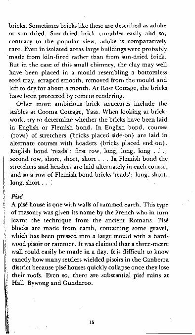
bricks. Sometimes bricks like these are described as adobe or sun-dried. Sun-dried brick crumbles easily and so, contrary to the popular view, adobe is comparatively rare. Even in isolated areas large buildings were probably m ade from kiln-fired rather than from sun-dried brick. But in the case of this small chimney, the clay may well have been placed in a mould resembling a bottomless seed tray, scraped smooth, removed from the m ould and left to dry for about a m onth. At Rose Cottage, the bricks have been protected by cement rendering.
O ther more ambitious brick structures include the stables at Cooma Cottage, Yass. When looking at brickwork, try to determ ine whether the bricks have been laid in English or Flemish bond. In English bond, courses (rows) of stretchers (bricks placed side-on) are laid in alternate courses with headers (bricks placed end -on ). English bond ‘reads’: first row, long, long, long . . .; second row, short, short, short . . . In Flemish bond the stretchers and headers are laid alternately in each course, and so a row of Flemish bond bricks ‘reads’: long, short, long, short . . .
PiseA pis^ house is one with walls of rammed earth. This type of masonry was given its nam e by the French who in turn learnt the technique from the ancient Romans. Pise blocks are m ade from earth , containing some gravel, which has been pressed into a large mould with a h a rd wood pisoir or ram m er. It was claimed that a three-m etre wall could easily be m ade in a day. It is difficult to know exactly how m any settlers wielded pisoirs in the Canberra district because pisd houses quickly collapse once they lose their roofs. Even so, there are substantial pisd ruins at Hall, Bywong and Gundaroo.
15
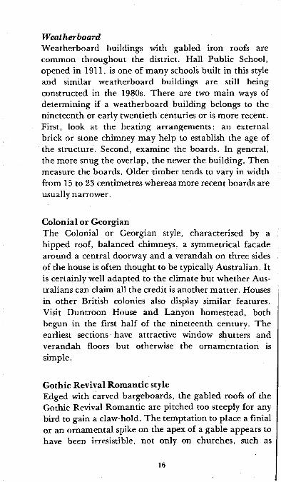
W eatherboardW eatherboard buildings with gabled iron roofs are common throughout the district. Hall Public School, opened in 1911, is one of m any schools built in this style and similar w eatherboard buildings are still being constructed in the 1980s. There are two m ain ways of determ ining if a w eatherboard building belongs to the nineteenth or early twentieth centuries or is m ore recent. First, look at the heating arrangem ents: an external brick or stone chimney may help to establish the age of the structure. Second, examine the boards. In general, the more snug the overlap, the newer the building. Then measure the boards. Older tim ber tends to vary in width from 15 to 23 centimetres whereas more recent boards are usually narrower.
C olon ial or G eorgianThe Colonial or Georgian style, characterised by a hipped roof, balanced chimneys, a symmetrical facade around a central doorway and a verandah on three sides of the house is often thought to be typically Australian. It is certainly well adapted to the climate but whether Australians can claim all the credit is another m atter. Houses in other British colonies also display similar features. Visit D untroon House and Lanyon hom estead, both begun in the first half of the nineteenth century. The earliest sections have attractive window shutters and verandah floors but otherwise the ornam entation is simple.
G othic R evival R om antic styleEdged with carved bargeboards, the gabled roofs of the Gothic Revival Rom antic are pitched too steeply for any bird to gain a claw-hold. T he tem ptation to place a finial or an ornam ental spike on the apex of a gable appears to have been irresistible, not only on churches, such as
16

W attle Park, Hall, but also on sheds at Tharw a. The two- storied extension to Duntroon House is a fine example of the style.
E arly V ictorian , about 1850 to 1860If an old house has a verandah there is one quick and reasonably accurate way to tell whether it was built before or after 1850. Look at the shape of the verandah roof. If it curves under it was probably built after 1850. As a rule of thum b, think of noses! Pre-1850 houses often have turned-up noses; post-1850 houses often have slightly hooked ‘bull’ noses. Straight noses were always com m on. But that was the problem, they were too com mon and the fashionable preferred to turn their noses up or down. In the Victorian age curves and asymmetry enjoyed a hey-day as the tops of verandah pillars were turned and drawing rooms ju tted out in front. Sheet or cast-iron and weatherboard became increasingly popular.
Mid- and late V ictorian , about 1860 to 1900Decorative cast-iron sometimes called iron ‘lace’, first im ported from England in the 1840s, was a great success in Australia and even reached as small a settlement as Bungendore.
Cast-iron panels, with their profusion of flowers and scrolls, were decorative, both in themselves and in the shadows they cast, durable, and easily attached to verandahs. Almost as im portant, especially to home- owners who had moved beyond the log-splitting phase of pioneering, cast-iron could be bought from a factory. The use of cast-iron was not limited by location or social class and it appeared on rural homesteads as well as town pubs.
Cast-iron was probably the period’s most popular decoration, but bow windows and decorated chimneys were also coveted. The 1891 extensions to Yarralum la,
17

Architectural Styles
TWO COMMON NINETEENTH AND EARLY TWENTIETHCENTURY RURAL STYLES (a & b)(a) Sally Paskins’ Store, G undaroo (slab c o n s truc t ion , external fireplace, hip roof)
(b) Public School, Tharwa (weatherboard,
gabled roof)
COLONIAL OR EARLY GEORGIAN c. 1820 to 1840 L anyon (straight, sloping verandah roof, plain verandah posts)
GOTHIC ROMANTIC REVIVAL c. 1840 to 1870
Wattle Park Church- Hall (decorative
bargeboards and finials, asymmetrical plan)
MID TO LATE VICTORIAN c. 1860 to 1900Caledonia Store,G undaroo (bull-nosed verandah roof, decorative urns)
TWENTIETH CENTURY (a & b)
(a) Melbourne Buildings, Civic (1920s Spanish Mission style)
(b) Austral ian Institute o f A na tom y , Canberra (1 930s geometric decora tion)
18

now Government House, show what was involved. A three-storied wing was surmounted by tall chimneys with elegant brick work tops, and a decorative iron railing ran along the ridge of the roof.
Although some semi-detached buildings were erected in the C anberra district and the remains of terraces exist in Q ueanbeyan, terraced housing on the scale of inner Sydney and Melbourne was unknown.
E arly tw en tie th-century stylesOne or two architectural styles popular in urban Australia virtually by-passed the Canberra district. There was little dem and for the turn-of-the-century Queen Anne style, with its flurry of turrets and chimneys. Melbourne and Sydney’s Art Nouveau craze was more or less whittled away to coloured window glass, leaded into stylised floral shapes by the time it reached this rural region.
Later in the century, when the planners of the national capital were looking for new ideas, they went farther afield than the Old Country. They drew m uch of their in spiration from America, where comparisons between climate and society were easily made with Australia.
The winner of the 1911-12 design competition for the national capital was a Chicago architect, W alter Burley Griffin. Using triangles and circles instead of straight intersecting lines, he broke with the traditions of gridiron town planning. Although Griffin did not determ ine the design of C anberra’s buildings, styles popular in America exerted a strong influence. The general idea of colonnades, arches and tiles for Civic Centre came from the Spanish white-washed, terracotta-roofed mission bu ildings in California and Mexico as well as from the designs of nineteenth-century shopping arcades. O ther major public buildings of the 1920s, particularly the Hotel Canberra, show the Californian bungalow style’s em phasis on ‘close-to-the-landscape’ design.
19

The first houses for public servants in the national capital were single-storied weatherboards. The bungalow remained the standard design but later brick, with or without stucco, became the most popular building m aterial. Some buildings looked back to specific historical periods. T udor England enjoyed a revival in learning and this idea lay behind the design of a m ock-Tudor day and boarding girls’ school, C anberra Church of England Girls’ G ram m ar School, in M elbourne Avenue begun in 1927.
The 1930s taste for decorating buildings with geometric designs and for flat roofs and vertical windows is clearly expressed in both the City Education Centre (formerly Canberra High School) and the Australian Institute of Anatomy.
20
Exploring Cemeteries
A wife most kind, a mother dear A faithful friend lies buried here,My days are past, my glass is run,Oh! Husband dear, prepare to come.
This epitaph with its curious mixture of the sentiments of the bereaved and the departed is on the headstone of M aria Follet(t) who died in 1882 in a fit of temporary insanity. She was buried at St Thom as’ Church, Carwoola, on the C aptain’s Flat Road. It seems that her husband, W illiam, was unable to hasten; indeed he rem arried in 1886 and it was not until 1902 that he joined M aria in the family burial plot.
Carwoola is only one of many readily accessible graveyards in and around Canberra. Others include those at St John the Baptist’s at Reid, W eetangera, Cuppa- cum balong, M urrum batem an, Bungendore, Upper Gundaroo, Gundaroo, Queanbeyan, Hoskinstown and C aptain’s Flat.
The casual visitor to a cemetery might find it rewarding to make a scattergram. Using a grid showing age at death (perhaps in ten-year spans) across the top, and date of death (again in ten-year spans) at the side, represent every grave by a dot marked in the appropriate square. The resulting pattern may raise interesting questions both about the district’s history and the value of cemeteries as historical sources. A Bungendore scattergram , for example, pointed to the longevity (70 + ) of many local inhabitants and to clusters of deaths of children under nine (from diphtheria and typhoid?), particularly before a sanitation system was

introduced into the town at the beginning of the first world war. In a more detailed research, impressions from scattergrams must be com pared with inform ation in birth, m arriage, death and burial registers because cemeteries rarely provide a complete record. On the other hand, some local registers are missing or incomplete and so even a crum bling headstone might provide the most comprehensive inform ation available.
Inscriptions often reveal the pioneers’ countries of origin, the years in which illness swept through certain districts, and general inform ation on infant m ortality and life expectancy. They may also draw attention to the tragic deaths which are an integral part of historical anecdotes.
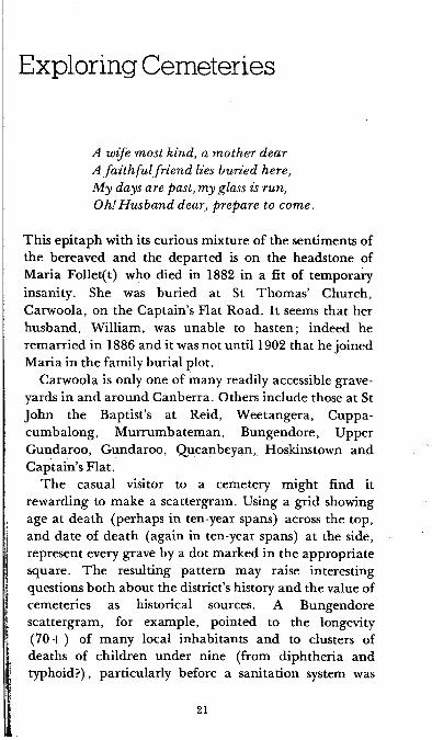
E D W I N EL ' JAH S A M P R I D ' E .
----Lj,
Headstones outside St John’s crypt showing two styles of nineteenth-century decoration, a draped urn, the traditional receptacle for the ashes of the dead, and the descending dove, representing the Holy Spirit
22

Try to determ ine the strength of certain religious denom inations within a particular district. If the graves do not lie in clearly defined areas, the style of headstone may provide a clue to religious affiliation. Roman Catholic headstones, for example, are often the most elaborate and are also more likely to contain a reference to Jesus and the letters RIP (Requiescat in pace: May he, or she, rest in p eace).
Headstones and surrounding railings often echo the simplicity or complexity of the designs popular in the houses of the period. The late-Victorian love of decoration, for example, is evident in the railings around the graves in the W eetangera cemetery, dedicated in 1873. Although cemeteries are a sensitive indicator of the district’s culture, the record they present is usually incomplete. Some locals were buried in private plots near their homesteads or elsewhere in Australia. Sometimes there was more than one local cemetery, as in the case of the Bungendore and Carwoola graveyards which serve the same district. Not all graves were m arked by headstones and m any of those which were have long since decayed. W orn inscriptions can sometimes be read more easily if chalk is gently rubbed over the stone’s surface but this must be done with great care in case the headstone topples and puts the investigator dangerously close to his subject.
Some people may wish to begin all their history tours with visits to burial grounds. At the very least, trips to a number of cemeteries help the explorer to appreciate the length of white settlement in the area and also give a sense of geographical direction in an unknown district because Christian graves face east, to catch the rising sun.
23
Nineteenth and Twentieth Century Canberra
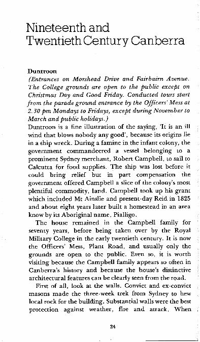
D untroon(Entrances on Morshead Drive and Fairbairn Avenue. The College grounds are open to the public except on Christmas Day and Good Friday. Conducted tours start from the parade ground entrance by the Officers’ Mess at 2.30 pm Mondays to Fridays, except during November to March and public holidays.)Duntroon is a fine illustration of the saying, ‘It is an ill wind that blows nobody any good’, because its origins lie in a ship wreck. During a fam ine in the infant colony, the government com m andeered a vessel belonging to a prom inent Sydney m erchant, Robert Campbell, to sail to Calcutta for food supplies. The ship was lost before it could bring relief but in part compensation the government offered Campbell a slice of the colony’s most plentiful commodity, land. Campbell took up his grant which included Mt Ainslie and present-day Reid in 1825 and about eight years later built a homestead in an area know by its Aboriginal nam e, Pialligo.
The house rem ained in the Campbell family for seventy years, before being taken over by the Royal Military College in the early twentieth century. It is now the Officers’ Mess, Plant Road, and usually only the grounds are open to the public. Even so, it is worth visiting because the Campbell family appears so often in C anberra’s history and because the house’s distinctive architectural features can be clearly seen from the road.
First of all, look at the walls. Convict and ex-convict masons m ade the three-week trek from Sydney to hew local rock for the building. Substantial walls were the best protection against weather, fire and attack. When

finished they measured 91 centimetres, as thick as a m an ’s arm is long.
As soon as the house was completed, it was a welcome sight for travellers, as the Polish naturalist John Lhotsky found in the summer of 1834. Lhotsky, who was on his way to the Snowy Mountains, trekked over the Limestone Plains in the parching heat taking occasional aerial ‘ba ths’ which m eant no more than removing his shirt. He washed off the dust with arsenic soap and sipped a concoction of sulphuric acid and sugar which he claimed was essential to keep his blood from boiling. In view of Lhotsky’s discomfort it is no wonder that Cam pbell’s house appeared a clean, romantic haven, overhung with vines, and with the last windows he was to find south of Sydney. One can only hope that as a naturalist, his enthusiasm was not dam pened by the spiders, reputed to be as large as a child’s fist, which fell on his face at night.
T he house, probably known at first as Limestone Cottage, was renam ed Duntroon in the 1840s after D untrune Castle, the Cam pbell’s ancestral home at Loch Creran, Argyllshire, Scotland. Links with Scotland were strong. The local administrative district was known as the County of Argyle before it became the County of Murray. Moreover Robert Campbell, who preferred to hire free labourers rather than convicts, recruited shepherds in Scotland and transported them to Sydney in his com pany’s ships. As late as the 1860s it was said that it was possible for Canberra children to reach their teens without being able to speak any other language but Gaelic.
Robert Campbell, like so many others in the district, was an absentee landlord even though, as it happened, he died in the grounds of Duntroon in 1846. His third son, Charles, m anaged the property until his fa ther’s death, when it passed to the fourth son, George, who took up residence in 1854.
25

T h e g ro u n d floor p la n of the original house helps to conjure up a p ic tu re of dom estic life at D untroon in the m iddle of the n ine teen th century.
Scullery £3nServant s room
BedroomHallway
Dining room
i— i3 i <D</)O
j i- nL■ il
II Double fire-places
Drawing room
Verandah
Symmetrical facade
The original Duntroon House, c. 1833-61
T h e g rea t oak, o r ‘F re d ’s tree’, which dom inates the n o rth -eas te rn section o f the garden , was p lan ted in 1861 to com m em orate the b ir th o f Frederick A rth u r, G eorge’s second son. George was know n as the Squire o f D un troon an d his style of living w as reflected in the extensions his wife helped design for th e house in 1862. T h e new wing was bu ilt in the latest G o th ic Revival R om antic style. T h e care taken w ith sandstone window surrounds an d carved
26

Victeonan extensions to D un troon House, showing the icing o f bargieboards and fin ia ls
27

bargeboards speaks of increased affluence. In addition to bedrooms, nurseries, a breakfast room, a m orning room, a servant’s hall and a cellar, the two stories contained hallmarks of a gentlem an: a study and a library. Stables, lodges and a greenhouse completed the country seat.
Further modifications were m ade in 1876, all of them indicative of increasing social refinement. The greenhouse, for example, became a conservatory with a conical glass roof. This circular area is now screened by lattice work.
For a first-hand experience of the garden’s delights, explore the maze near Robert Campbell Road. Based on the H am pton Court maze, it had been planted by 1870. Allan Mortlock and Bernice A nderson’s book Undiscovered Canberra holds the key to the puzzle.
Although Duntroon became a centre for dances and parties, there was tragedy as well as pleasure. In 1885 Sophia Campbell and her friends went to see a female performer and tried to copy some of the tricks in Sophia’s bedroom. Gales of laughter were followed by piercing screams when Sophia put her feet behind her head. She died within hours and the memorials to her in St John’s Church indicate the depth of her family’s shock. Samuel Shumack, who recorded the incident in his autobiography, was more cynical, saying that had she led a more active life she would not have injured herself so badly.
During the nineteenth century the family increased their holdings with land in every direction: along the Cooma Road and at W oden, N arrabundah , M ajura, and Belconnen, and a cousin owned Yarralum la station.
After Mrs George Cam pbell’s death in 1903, the house remained vacant until Lord Kitchener of pointing finger and your-country-needs-you fame recom m ended the establishment of the Royal Military College. The Commonwealth government acquired the lease of the estate in 1910, when William Throsby Bridges became
28

the first com m andant. He was related to Dr Charles Throsby and so for all the change in D untroon’s function, there was also a sense of continuity with C anberra’s past.
D u n tro o n D airy(Reached by track off the hill side of Morshead Drive near Lavarack Road.)D untroon Dairy, built on the lower slopes of Mount Pleasant in the 1830s, was set well into the hillside to keep cool. T he only people who could ever have been warm inside were those churning the cream to make butter. W hen St John’s Schoolhouse was gutted by fire in 1864 the Dairy became a tem porary classroom and no doubt the children found the internal tank (perhaps for storing water?) a source of great fascination. The Dairy is now an archaeological site and the exterior has been restored, though to be authentic, the roof eaves on the front should reach the ground, keeping the dairy even cooler.
St Jo h n the Baptist and the L ean ing Spire(Comer of Constitution Avenue and Anzac Parade, Reid.)The Anglican church of St John the Baptist was nam ed after the man who preached in the wilderness. This allusion was appropriate in the 1840s when the church, the first on the Limestone Plains, stood alone at the foot of Mt Ainslie.
Robert Campbell donated land for the church and Bishop Broughton, the first and only bishop of the whole of Australia, helped to select the site. The original choice was near Duntroon but later it was decided that a site to the north of the homestead was more accessible to the whole district.
The newspaper accounts of the laying of the foundation stone on 11 May 1841 and the consecration on 12 March 1845 clearly reflect the British heritage and terminology of the early settlers. The locals were referred
29

to as ‘gentry, farmers and peasantry’, the similarity of St John’s to ‘an old English Village C hurch’ was noted with pride, and hope was expressed that the ‘native blacks’ and ‘any benighted people of whatever caste and colour may be shown the glorious light of the Gospel’.
To appreciate the size of the original church, go inside, walk down the aisle and near the pulpit on the south (right-hand side wall facing the altar) note the brass plaque which marks the original eastern end. The extension of the nave and the chancel, where the altar now stands, was added about thirty years after the original building. The stones for the extension were said to be those left over after the renovation of Duntroon House. It is not surprising that the Campbell family is prom inent among the pioneer families comm em orated. The Australian-m ade stained-glass window above the altar is one of the earliest of its kind and bears the Campbell family crest and m otto Agite pro viribus — Work with all your might.
The tragedies as well as the trium phs of the pioneers are recorded in the wall plaques. One early tablet high on the nave’s north side (left-hand side facing altar) pays tribute to the life of Catherine, wife of Charles Campbell. She died in 1863, aged forty-eight, ‘after a lingering illness brought on by the death of her eldest son, a scholar of Trinity College, Cam bridge’. The sad story was that at Duntroon her eldest son W alter, while playing with a bow and arrow, killed a boy nam ed McIntyre. T he Campbells were so devastated by this misfortune that they left Duntroon for England, where W alter went on to Cambridge. During bumps on the river, W alter was struck by another boat and died at the age of twenty-two. A window in Trinity College Chapel is consecrated to his memory.
Also on the north side is a plaque to M ajor-General Sir William Throsby Bridges, who died as a result of wounds received at Gallipoli and is buried on Mount Pleasant, in
30

an area open to the public reached by General Bridges Drive.
The font stands on the south side of the nave. The wooden cross pieces in the centre are from the altar rail of the church where Horatio Nelson’s father was vicar at the time of his son’s birth.
W alking out of the church, look up at the military banners hanging from the gallery and at the memorial to H erbert Vere Evatt, who was elected President of the United Nations General Assembly in 1947.
The steep stairs in the porch lead to the gallery and from here, observe the adze marks on the original cedar ham m er-beam roof.
Outside the church, note the original section, constructed of blue-grey volcanic stone quarried in the present day suburb of Campbell. The buttresses, windows and door mouldings are of Black M ountain sandstone.
The spire has its own story. The original church had a square sandstone tower. But the foundations subsided, it listed badly, was struck by lightning and was finally demolished in 1864. The following year, Bishop Mesac Thomas, first bishop of Goulbum , optimistically laid the foundation stone for a replacement but this project was to take fourteen years to complete.
The architect of the new tower and spire was Edm und Blackett, an Englishman who m igrated to A ustralia to escape parental disapproval of his m arriage. He designed many major buildings, including the Great Hall at Sydney University and Goulburn Cathedral. But there were times when the building to which he did aspire, as one might say, encountered difficulties. He had trouble with spires and towers in M aitland and Geelong and the work at Canberra was a protracted business. W hen it rained and the land became boggy, the stones rolled off the drays. The situation was even worse in a drought, when there were no teams at all to haul the drays. The builder, one Mr James Burton (said by some to be called
31

H en ry ), had a good reputation in his trade, but in other respects, his standing in the community was less than sound and in the middle of the delays another builder was asked to complete the task. Samuel Shumack reports the rum our tha t Burton’s real nam e was Hodge and that he had a wife and family in England as well as a wife and children in Canberra. B urton’s Canberra family left him, he was ignored by his neighbours, and later his tools were found to have the letter ‘H ’ stam ped on them . There were sufficient grounds for the rum our for the story to be repeated at the inquest and subsequently in the Quean bey an Age.
T he present spire was completed in 1878. Because of a shortage of tim ber, the ribs were about four metres short of the stipulated height and when they were pulled together, the spire was asymmetrical. A sailor climbed up to put on a tin cap and in 1921 a finial was added to aid the eye, bu t the spire still has a definite tilt.
The ChurchyardThe graveyard at St John the Baptist’s is distinctive in C anberra because it is the only one close to a church. It was also the first to be consecrated and pioneers from all denom inations are buried here.
One of the most interesting graves is in the crypt which can be reached by stone steps at the eastern end. Here lie the rem ains of the first rector, George Edward Gregory, who drowned in the Molonglo in the winter of 1851. He had been visiting parishioners on the other side of the river from his rectory. Much to his friends’ surprise, he told them that he intended to swim the flooded river, an enterprise which frightened even his horse. But Gregory, a healthy twenty-five-year-old and a cham pion swimmer, would not be dissuaded. He was also anxious to return to the rectory because he was studying for his ordination exam ination and was soon to be m arried to the sister-in- law of the Reverend Edward Smith, Rector of
32

Q ueanbeyan, who had laid St Joh n ’s foundation stone. Indeed, his fiancee's furniture was already at the rectory. As he plunged into the river, a friend ran alongside holding out a coat but to no avail. Gregory was swept away by the current and sank. His grave originally lay outside the church but was covered by the extension of the chancel.
Also in the crypt, there are the remains of a Campbell baby and of Bishop Radford, the fourth Bishop of Goulburn, who hoped to be reinterred in the Anglican cathedral for which he worked so hard . The site for the cathedral is m arked by a cross near St M ark’s library but the cathedral itself has not been built. Ernest Henry Burgm ann, the first Australian-born Bishop of the Diocese, who died in 1967, also lies in the crypt.
The oldest m arked grave is the vault erected in 1845 of the Guise family of Bywong. The inscription on Sarah and George W ebb’s headstone nearby is often referred to by local historians as ‘prophetic’: ‘For here we have no continuing city, but seek one to come’. T he Webbs once owned the property Tidbinbilla, now the nam e given to a nature reserve. Sarah W ebb’s funeral procession contained some of the most dram atic elements of Victorian mourning. Her mother, who had arrived too late to see Sarah alive, insisted on having the coffin opened so she could cut a lock of her daughter’s hair.
St J o h n ’s Schoolhouse(Open on Wednesdays 10 am to 12 noon; Saturdays and Sundays 2 to 4 pm; public holidays 10 am to 4 pm.)This was inner C anberra’s first school from the early 1840s to the 1880s when it was replaced by one at Springbank, now the name of an island in the lake. St John’s Schoolhouse is a museum of local church and school history and contains many photographs and artefacts of early Canberra.
33

B lu n d e ll’s Farm house(Wendouree Drive, Parkes. Open 2 pm to 4 pm daily, also Wednesdays from 10 am to noon; admission free.) Blundell’s Farm house stands as a record of the Campbell family’s efforts to m ake life more com fortable and secure for their employees. The first occupants, William and Mary Ginn, had em igrated from Hertfordshire and in 1857 W illiam becam e the head ploughm an at Duntroon. Ginn’s popularity with the Campbells made other workmen jealous and one of them knocked out four of Ginn’s teeth and splintered his jaw with a frying-pan handle. In spite of these early difficulties, Ginn continued to work for the Campbells for the next ten or so years.
It is not recorded whether Ginn missed the green fields of Hertfordshire as he ploughed the dry limestone plains, but his new life certainly had one great advantage. Like all the Campbell family’s leading workmen he was given a well-built house and, in this case, the right to work eighty hectares of the surrounding land.
The stone cottage, located within five minutes walk of St Jo h n ’s, was com pleted about 1860. The original section, which housed William and Mary and their four children, consisted of the four front rooms. The Ginns were squeezed for space but less so than their successors, George and Flora Blundell, who had eight children and were forced to build extensions: first the shed and later the short passage and two other rooms. Unlike W illiam Ginn, George Blundell was born locally. George worked for the Campbells as a bullock driver and Flora became the district’s midwife. The Blundells and their descendants lived in the house for fifty years, an occupancy which justified giving the cottage their nam e.
In 1932 the Blundells made way for Harry and Alice M atilda Oldfield. Mrs Oldfield lived at the cottage until her death in 1958, only a few years before Lake Burley Griffin covered the Molonglo River’s lucerne pastures. By
34

the 1960s Blundell’s was the sole survivor of similar cottages on the Cam pbell’s Duntroon property and has been carefully preserved in spite of all the changes within the ‘parliam entary triangle’.
T he farmhouse is m aintained by the C anberra and District Historical Society which has produced an excellent illustrated guide. Very few of the items on display at Blundell’s were used here, and it is certainly better furnished than it was in the days of the Ginns, but most o f the objects come from homes in the surrounding district. The walls are of sandstone and porphyry, the same locally quarried rock used in St John’s. The slab shed, once divided into the kitchen and boys’ bedroom, has clay packing and tin strips between the slabs in an effort to keep out the draughts. Tools for m aking shingles are kept inside the shed. From the old D untroon Dairy there is a large iron cauldron used for scalding pigs and from Hall, George Kinlyside’s rabbit poisoning cart.
Inside the house, perhaps the one item which evokes the clearest picture of the past is the hip bath from the Brindabellas. A bath like this was used by the Blundells, who carried water up from the Molonglo River on sleds. On cold winter evenings when the eight children waited their turn for the bath, one can only hope that the kitchen fire was burning brightly.
G overnm ent House, Y arralum la(Lady Denman Drive look-out, Yarralumla. Government House and grounds are not open to the public. Lady Denman Drive look-out is on the site of Taylor’s hut (hence Mt Taylor) and from here there is a good view of Government House.)Yarralumla property was one of the first in the district. Its nucleus dates from 1828 and the old spelling, Yarrowlumla, which appears in Robert Dixon’s survey m ap of 1829 is still m aintained in the nam e of the shire. Y arralum la’s colourful owners included Francis Mowatt,
35

a Sydney civil servant who conducted kangaroo hunts complete with fox hounds. Unlike Mowatt, Terence Aubrey M urray who purchased the land with Thomas W alker in 1837, was a resident landlord. The district’s first m em ber of parliam ent, T .A . Murray, was knighted after a distinguished career and was the father of two famous sons, Sir H ubert M urray, Lieutenant-Governor of Papua from 1908 to 1940 and Gilbert Murray, OM, Regis Professor of Greek at Oxford and an active participant in the League of Nations.
The property was sold to T . A. M urray’s brother-in- law, Augustus Gibbes in 1845 and thirty-six years later passed into the ownership of Frederick Campbell, who m ade Y arralum la into a model station. The three-storied homestead built in 1891 was certainly one of the grandest in the district. Acquired by the Commonwealth in 1911, the homestead was used for the first Cabinet m eeting in the Territory on 30 January 1924. The house was subsequently remodelled as the vice regal residence, Lord Stonehaven becoming the first occupant of Yarralum la in its new role.
T he shearing shed on the opposite side of the road from the look-out, dates from the beginning of the twentieth century. It contained twenty stands and up to five thousand sheep at a time bleatingly waited to have the wool pulled over their eyes.
R osebud A piary (H ill View)(Skinner Street, Cook — private property.)A slab hut in the middle of suburban development tells the story of C anberra’s encroachm ent on rural areas. The hut has stood on two sites, first at G inninderra and then at W eetangera. Dating from the mid-1860s, it was originally owned by Mark Southwell who leased it to George Harcourt, proprietor of the G inninderra store. H arcourt was then in a position to help three local girls who were looking for a job and a place in which to work
36

Rosebud Apiary (Hill View) — a slab hut in the middle of a modern Canberra Streetas seamstresses. He offered them the cottage and they set up business as the first clothing ‘factory’ in the district. They earned 4d. for each shirt made but unfortunately they were undercut by Anthony Hordern of Sydney and closed after about a year.
By 1879, Mark Southwell had been bought out by R ichard Shumack under the provisions of the Robertson Land Act and, in that year, the Shumacks swept through their purchase with a new broom. They dism antled the house and re-erected it as the Rosebud Apiary on its present site.
Although the cottage was a simple structure, occupants took pride in its upkeep and the walls were lime-washed each year in time for Christmas. On one occasion the Apiary was severely threatened when flames destroyed the furniture and the hessian ceiling, but fortunately the hardwood slabs survived.
37
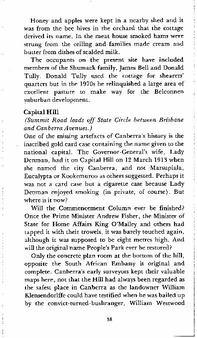
Honey and apples were kept in a nearby shed and it was from the bee hives in the orchard that the cottage derived its name. In the m eat house smoked hams were strung from the ceiling and families m ade cream and butter from dishes of scalded milk.
The occupants on the present site have included members of the Shumack family, James Bell and Donald Tully. Donald Tully used the cottage for shearers’ quarters but in the 1970s he relinquished a large area of excellent pasture to make way for the Belconnen suburban development.
Capital Hill(Summit Road leads off State Circle between Brisbane and Canberra Avenues.)One of the missing artefacts of C anberra’s history is the inscribed gold card case containing the nam e given to the national capital. The Governor-General’s wife, Lady Denman, had it on Capital Hill on 12 M arch 1913 when she named the city C anberra, and not M arsupiala, Eucalypta or Kookemuroo as others suggested. Perhaps it was not a card case but a cigarette case because Lady Denman enjoyed smoking (in private, of course). But where is it now?
Will the Com m encem ent Column ever be finished? Once the Prime Minister Andrew Fisher, the Minister of State for Home Affairs King O ’Malley and others had tapped it with their trowels, it was barely touched again, although it was supposed to be eight metres high. And will the original nam e People’s Park ever be restored?
Only the concrete plan room at the bottom of the hill, opposite the South African Embassy is original and complete. C anberra’s early surveyors kept their valuable maps here, not that the Hill had always been regarded as the safest place in C anberra as the landowner William Klensendorlffe could have testified when he was bailed up by the convict-turned-bushranger, W illiam Westwood
38

(JackyJacky) in the 1840s.In 1920 the Prince of Wales (later Edward VIII who
was to abdicate and m arry Mrs Simpson) was attended by great ceremony on the Hill to lay the foundation stone of the Capitol, a building for celebrating Australian achievements. The Prince quipped that Canberra consisted chiefly of foundation stones and he was partly right. His stone has long since been removed to the W ar Memorial basement and the Parliam ent House now planned instead of the Capitol for the spot, may not be completed until 1988. This seems poor reward for a hard day. The Prince shook hands with hundreds of schoolchildren, until, withdrawing his aching fingers, he offered his left hand instead of his right. ‘T he other hand, please’, said a small boy.
Mt Stromlo Observatory(Cotter Road and Stromlo turn-off through pine forest. Visitors’ Centre open from 9.30 am daily; admission
free.)The site for the observatory, selected in 1910, was one of the first areas in the Territory to be designated for a specific purpose, and by the following year a dome was ready to receive a twenty-five centimetre refracting telescope. The observatory’s first director, Dr W . G. Duffield, is buried on Mt Stromlo.
Australian National University Staff Centre(Balmain Crescent, Acton.)Early Canberra was a town of one-storied dwellings and so any two-storied house was sure to denote the high public position of its occupant. The office of the Commonwealth Architect John Smith M urdoch designed the impressive home now used as the ANU Staff Centre in 1912 as the official residence for the Adm inistrator of the Federal Capital Territory.
The tim ing of the construction was partly the result of an icy relationship between the autocratic Secretary of the D epartm ent of Home Affairs, Colonel H. C. Miller, and the flamboyant new Minister of Home Affairs, King O ’Malley. O ’Malley strongly disliked the use of military rank in civil affairs and, to embarrass men such as Colonel Miller, O ’Malley invariably addressed the messenger as ‘Brigadier G eneral’. O ’Malley and Miller could not agree on departm ental m atters and so it was arranged that Colonel Miller be transferred to the position of ‘A dm inistrator of the Federal Capital T erritory’ and that a suitable residence for him should be built in C anberra. O ’Malley now had more freedom in Home Affairs and Miller enjoyed his A dm inistrator’s status which carried the right to be called ‘Your Excellency’.
At first the building housed visiting senior public servants. The caretakers were an eccentric cockney couple, Mr and Mrs James Phillips, both of whom could have stepped out of a Dickens novel. Jimmie was extremely short-sighted and his wife suffered a m ental disturbance for which she sought treatm ent outside Canberra. Jimmie recounted the story that when they presented themselves at the mental institution, the receptionist, after close scrutiny of the quaint pair, inquired which one was to stay.
One of the best known perm anent occupants of ‘Canberra House’ or ‘The Residence’, was Sir John Butters who was appointed Chief Commissioner of the Federal Capital Commission in 1924. Later, it became the home of the British High Commissioner, the Commonwealth Club and, since 1965, the University Staff Centre. Despite extensions and modernisations, members can still enjoy the wood-panelled walls and an open fire in one of the original reception rooms.
40

B achelors’ Q uarters(Balmain Crescent, A cton.)T he wooden buildings erected on the Acton Peninsula in 1912 were known by the 1920s as the Bachelors’ Quarters where men lived during C anberra’s construction period. Later the buildings became the Acton Guest House and subsequently part of the University.
T h e Pow er House, Kingston(W entw orth Avenue, Kingston.)It is perhaps strange to adm it a sentimental attachm ent to a power house, but it was one of the first perm anent buildings constructed in the centre of the national capital and it is a rem inder that the city developed in the electricity age. The steel-framed concrete structure has close links with W orld W ar I. In August 1914, two German m erchant ships, the Apolda and the H am m , heavily laden with cement, were in A ustralian waters. They were promptly seized as prizes of war and the cement was used for the power house and the Cotter Dam.
Coal for the electricity came from Newcastle and Berrima. Once the coal had been unloaded from the railway, it was treated with an array of equipm ent, the very names of which seem to generate activity. There were Beilis and Morcom high-speed enclosed reciprocating engines and Babcock and Wilcox boilers with super-heaters and mechanical stokers. On Sundays, the power house knew quieter activities when Rom an Catholics celebrated Mass there.
The power house supplied ice blocks w rapped in sawdust and wheat bags, and delivered to homes and the Bachelors’ Quarters by horse and dray.
Although the ACT Electricity Authority still operates from the site, the power house itself ceased operation in the winter of 1957 and many of its interior fittings have been sold.
41

The Commonwealth Brickworks(Denman Street, Yarralumla.)The transform ation of the old brickworks to a major leisure and museum centre began at Yarralum la in the mid-1970s. The production of the characteristic orange- red Canberra bricks bearing the stamp ‘Canberra Com m onwealth’ started in 1914, closed during the war years, and resumed in 1921. Those with a love of peripheral inform ation might like to know that the 1927 Parliam ent House absorbed 4,000,000 bricks and the Hotel K urrajong 544,000. T he arches of the kilns make the disused brickworks look like the crypt of an old cathedral. Indeed, in the early days, the brickworks was used for Church of England services.
The Prime Minister’s Lodge and the Forrest Housing Group(Corner Adelaide Avenue and National Circuit, Deakin.)The Lodge was first intended for the Speaker of the House of Representatives but when it was completed in 1923 it was occupied by the Prime Minister. Although the Lodge is not open to the public it is worth looking through the gates, to see the Oakley, Parkes and Scarborough design. There are other, if less prestigious, examples of this architectural firm ’s work nearby. Oakley, Parkes and Scarborough won the first Sulman competition for a housing group between Dominion and Empire Circuits. Forrest, m ainly to accommodate C anberra’s early public servants. Some of these houses have since been altered but originally they were brick, often with stucco finish, and with a hint of Spanish Mission influence in an arch or two. The first residents were not always happy with the chimneys, claiming that the wintery south-west winds filled the rooms with smoke. The suburb has one of the most confusing street plans in
42

C anberra bu t this is to be attributed to the work of another en tran t in the Sulman competition and not to W alter Burley Griffin.
H ote l C anberra( Corner o f Commonwealth Avenue and A lbert Street.) T he Hotel C anberra’s guest book is a W ho’s W ho of early C anberra history. Opened in 1924 as the Hostel, the building in Commonwealth Avenue was already the home of politicians, journalists and public servants by the time Parliam ent House was opened. It provided much needed accommodation but not alcoholic refreshm ent. T he hotel was unlicensed from 1924 to 1928, in keeping with the policy of keeping Canberra ‘dry’ during the construction period.
Designed by John Smith Murdoch, who later drew up the plans for Parliam ent House, the main block included a dining room, lounge rooms, a drawing-room and, so tha t the gentlemen could retire in comfort, a smoking room and a billiard room. The surrounding garden originally contained tennis courts, bowling and croquet greens and a nine-hole golf course. Of these only the croquet green remains.
In 1929, at the beginning of the Depression, the Labor Prime Minister, James Scullin, and his wife lived in the Hotel C anberra rather than authorise the expense of living in the Prime Minister’s Lodge. W hen Scullin’s economic plans were being frustrated by both the Commonwealth Bank and the Senate, he adopted the touching if futile habit of asking the hotel’s cashier to change notes for shillings which he then threw to people as he travelled by car to Sydney and M elbourne.
The hotel has had its fair share of intrigues. On 2 October 1941, the life of A rthur Fadden’s government depended on the votes of two Independents, Alex Wilson and A rthur Coles. Victory or defeat ultim ately rested with Coles but he would not come out of his room. In the
43

lobby, great schemes were laid to win Coles over and notes were pushed under his door. But it was no use. Next day A rthur Fadden gave way to John C urtin’s Labor government.
The hotel, leased for many years by the beer company Tooheys, is now occupied by a government departm ent.
P arliam ent H ouse(King George Terrace, Parkes. Open 9 am to 3 pm Mondays to Saturdays; 9.30 am to 3 pm Sundays; 1 pm to 3 pm Good Friday and Anzac Day; closed Christmas Day; admission free.)T he battle of the sites has dom inated C anberra’s history. First there were argum ents over the best place to locate the national capital, followed by half a century of debate over the most suitable site for Parliam ent House.
C anberra’s designer, W alter Burley Griffin, thought that Parliam ent House should be built on Cam p Hill. The building would suit A ustralia’s dem ocratic tradition: it would have presence without lookingauthoritarian . A survey peg was duly ham m ered into the ground on 20 February 1913. But this was the last that this particular spot was to see of Parliam ent House.
The first world war and lack of money caused delay after delay. A lthough an international com petition had been organised for the building’s design, professional architectural bodies com plained that too many of their members were away fighting. W hen the project was revived after the war, the Commonwealth architect, John Smith M urdoch, wanted to see Parliam ent House on top of Capital Hill. Griffin, not unnaturally , protested. The House of Representatives adopted a compromise solution. A provisional Parliam ent House was to be built on the lower slope of Camp Hill, enabling more careful thought to be given to the location and design of a perm anent structure. Griffin was horrified. T o build a ‘tem porary’ Parliam ent House, which m ight never be
44

pulled down, right in front of the perm anent structure, ‘would be like filling the front yard with outhouses’. But the government decided to press on with a building on the compromise site.
Locals remem bered lower Camp Hill as the place where a shepherd was badly injured by hailstones during a wild storm in 1876. Forty-seven years later, there was no time for even a foundation stone. On 28 August 1923, the Minister for Works and Railways, sat Up proudly in the cabin of a steam-shovel and turned the first sod. By 1925 as many as two hundred and fifty people were working on the site. Bricks from Yarralumla were carried on a narrow gauge railway, but some entrepreneurs thought they had a better system. They bought T-Model Ford trucks for $250 each, carted bricks at a great rate and then sold the well-worn vehicles to unsuspecting Sydney buyers for about $100 each.
Parliam ent House was officially opened by the Duke of York (later, after his brother’s abdiction, to become George VI) on 9 May 1927. The day was a curious mixture of pomp and ceremony, disaster and disappointm ent. The Duke’s gold key opened the door and Dame Nellie Melba sang the N ational Anthem , but an aeroplane crashed after the flypast killing the pilot, Flying Officer F. E. Ewen, and the huge crowds expected throughout the day never materialised. Somewhere on Camp Hill lies the unknown grave of thousands of untasted m eat pies.
Inside Parliam ent House, immediately behind the main doors is King’s Hall nam ed after George V. The busts around the walls with their fixed stares all look very much the same. More life-like is the large painting depicting the Senate Cham ber at the Federal Parliam ent’s inauguration in 1927.
Two old documents deserve inspection. The first is a rare and valuable copy of the 1297 version of the Magna C a rta ; the second is the Commission signed by Queen
45
Victoria, m aking Australia a Commonwealth from 1 January 1901.
Parliam entary procedure is explained in an exhibition in the basement. The Australian parliam ent closely follows the W estminster tradition and there are many tangible links with Britain. In the House of Representatives, the Royal Arms over the Speaker’s chair are carved in oak from W estminster Hall (1399) and the hinged flaps on the arm rests are from Nelson’s flagship, the Victory, which fought at the Battle of T rafalgar in 1805. A bit of a ship is no doubt a handy thing to have when broadsides are being delivered.
The ceremonial dress of the Sergeant-at-Arms in the House of Representatives and the Usher of the Black Rod in the Senate tell of the days of jabots and knee-breeches. But as well as a host of traditions, the 1927 Parliam ent House was built with m odern touches: a three-kilometre long underground pneum atic tube to the Government Printing Office and the provision of individually controlled heating to every m em ber’s seat.
The Albert Hall( Comer o f Commonwealth Avenue and Albert Street.) Those with a feeling for the m inutiae of C anberra’s history find it satisfying to note that decades before the Albert Hall was planned, one of the district’s first pianos was played close by. The pianist was Mrs Mary Mowle, the daughter of the founder of Braidwood, whose home, Klensendorlffe’s farmhouse, now lies under the waters of Lake Burley Griffin.
The Albert Hall was opened in M arch 1928 by the Prime Minister, S. M. Bruce. It was given its name after the Albert Hall in London and also because the first name of the Duke of York, who had opened Parliam ent House, was Albert.
The designer, J. H unter Kirkpatrick, used arched windows and a large gallery to give the ‘Renaissance
46

Revival’ building a certain degree of elegance. But some of the Hall’s style was lost when concert-goers trailed in blankets and hot-water bottles to protect themselves against icy winter draughts. C anberra audiences gained the reputation of being emotionally, as well as physically, cold. In 1963, Rita Streich of the Vienna State Opera criticised the audience for not clapping loudly enough. But the local residents were not always difficult to please. Performances by John Masefield, Joan Sutherland, Dame Sybil Thorndike, Isaac Stern and a m ultitude of others were heady highlights in the life of the bush capital. On the political scene, the Albert Hall saw the opening, in May 1954, of the Petrov Royal Commission into Russian spying.
Of the m any dances, flower-shows and community gatherings held in the Hall, one of the largest was a party held in 1978 for Gough W hitlam on his retirem ent as leader of the Labor party. In 1975 his government had been dismissed by the Governor-General, Sir John Kerr.
Canberra University College and the Australian National University(Acton.)In 1930, when the national capital was feeling the pinch of the Depression, the government established the Canberra University College, which was officially attached to the University of Melbourne. Because money was tight, C anberra’s planners were forced to believe with Milton that ‘the m ind is its own place’. For many years the academics and students lacked a perm anent home. The first students, mainly public servants, attended lectures at the Telopea Park Interm ediate High School. Practical work in N atural Philosophy was arranged with the Royal Military College, Duntroon. Classes were held
I from 1931 to May 1935 at the Institute of Anatomy and then from June, in the wing of a building formerly used as
I the Hotel Acton.
47

From the mid-1940s the College was housed above the arches of the Melbourne Building in Civic, until a fire broke out there on 11 April 1953. Thereafter, it moved to the fibro ex-hostel buildings in Childers Street, Turner. The occupants boiled in summer and froze in winter, enjoying that communion of discomfort which so often makes the old days seem so good.
The Childers Street Hall saw countless plays and revues. Its wooden walls also trapped students for the compulsory examinations, held in November. At least the hall had the virtue of many windows, which m eant that the nam e of the winner of the annual Melbourne Cup horse-race could be paraded on placards outside for the benefit of the interred examinees.
In September 1960 the C anberra University College combined with the Australian N ational University, which had been formed in 1948 but consisted only of research schools. Although a spate of new buildings followed the merger, the University still occupies many of the Childers Street huts.
Then and now: T he remains of some early landmarks Acton HouseActon House was the site of the first perm anent white settlement in C anberra. Joshua John Moore’s overseer and stockmen built slab huts and yards in about 1824. These were replaced by a stone and pise" cottage in the 1830s. A new owner, A rthur Jeffreys, called the building Acton House. Extended and renovated m any times, Acton House was St John’s first rectory (1850-73), a home for the surveyors of the federal capital site, a police station and a court house. It was demolished early in the second world war, partly because the United States wanted to build a base hospital, a project which was never carried out. It is com m em orated by a fountain in the forecourt of the Royal Canberra Hospital.
48

Glebe HouseSt Joh n ’s second rectory, Glebe House, designed by A. D. Soares, was painstakingly built in the early 1870s from bricks m anufactured on the site. In 1926 it became St G abriel’s, the first Anglican girls’ day and boarding school, and was later a boarding house. The ‘Old Rectory’ was demolished in the 1950s. Its site is marked by a plaque in front of Narellan House, Ballum bir Street, Reid. T he oldest trees are those planted by the Reverend Pierce Galliard Smith, rector of St John’s throughout the second half of the nineteenth century. Glebe House bricks were used for the Acton Football Club, Forrest.
Canberra Post O fficeThe old C anberra Post Office (c. 1880-1925, renam ed Ainslie Post Office in 1913) is marked by a plaque at K anangra Court Flats, Reid.
Public SchoolThe Public School first opened in 1894 with twenty-three pupils. Popularly called the Crossroads School because it stood on the intersection of two roads on the Campbells’ M adura (sic) property, its official title was D untroon Crossroads School, and after 1904, N errabunda (sic). It closed in 1923 when Telopea Park, the first school built by the federal adm inistration was opened nearby. It is com m em orated by a plaque at the Fire Station, on the com er of Empire Circuit and Fitzroy Street, Forrest. The school itself was at the northern intersection of these streets.
i Molonglo In ternm ent Camp The area used during the first world war for the internm ent of German nationals from the Com m onwealth and the Pacific region is now part of the Fyshwick industrial area.
49

RailwaysA railway from Kingston crossed the Molonglo River on a wooden trestle bridge to an area near the Australian- American Memorial and then to Lonsdale Street. It was destroyed by flood in 1922-5. The Griffin Centre, Bunda Street, City, is on the platform site. There was also a railway from Parliament House to the Brickworks, built in the late 1920s. This survives as the railway cutting in the pine plantation beside the North Woden-Yarralumla Uniting Church in Maxwell Street, Yarralumla.
Haslam ’5 Creek Receiving HouseThe Haslam’s Creek Receiving House was built at Rookwood Cemetery, Sydney in 1868. Funeral trains reversed into it so that the last coach, carrying the coffin, was the first to reach the platform. Bought for <£100 in 1957, it is now All Saints’ Church in Cowper Street, Ainslie. The present vestries were formerly men’s and women’s retiring rooms.
50

Tours from the Federal HighwayLake George(North from Canberra City Post Office along Northbourne Avenue which becomes the Federal Highway. Distance to Lake George is approximately 33 kilometres.)One of the best points to begin a history tour of the Canberra district is at the place the Aboriginals m entioned to the first white explorers in 1820. This was W ee-ree-waa, later to be called Lake George. Wee-ree- waa was by no means sacred to the local tribes but they thought it was mysterious. The explorers and the settlers who followed were soon to find out why.
It was on a freezing wet Saturday, 19 August 1820, that Joseph W ild, an ex-convict overseer under the instructions of Dr Charles Throsby, and W ild’s two companions first stood on the shores of W ee-ree-waa. For the next week the men explored the lake and from a hill near present-daty Bungendore Wild described snowcapped m ountains, probably the Brindabellas. Around the lake he noticed kangaroos, emus, swans, geese and ducks but it was too cold to fish, if indeed there were any fish. The brackish water was undrinkable and the lake seemed subject to sudden changes in level. W ild reported that one night the water fell six inches. His was the first record of a phenom enon which was to puzzle many other observers.
In spite of the lake’s shortcomings, W ild’s reports of the surrounding countryside were good. Governor M acquarie was inspired to see it for himself. Led by Charles Throsby, he set out two months after W ild’s first visit and renam ed the waters Lake George after the reigning British monarch.
51
Of the men associated with the discovery and early recording of Lake George, three came to sad ends. Charles Throsby, who had enjoyed a career as a naval surgeon, adm inistrator, grazier, road-building supervisor and explorer, com m itted suicide after becoming involved in a tangle of debts and court cases; Joseph Wild was gored to death by a wild bull at the age of eighty-eight and Joseph Lycett who engraved a view for M acquarie was arrested for forging bank-notes and killed himself rather than stand trial.
The lake shores were settled soon after M acquarie’s visit. Some areas had been promised as ‘rewards’, others were bought. By 1828 the lake had been well surveyed and an im portant trigonom etrical base line had been let down at the northern end in conjunction with Governor Darling’s great project, a m ap of the nineteen counties. Surveyors thought that the lake was a good landm ark and used it again for a survey of New South Wales in 1868. But their efforts were spoiled when the lake suddenly rose, covering the line and forcing them to move it well back to the south-eastern side. T he stone pillars of this survey are still visible.
The rise and fall of the waters was a great puzzle. First there were m inor changes in level such as those W ild had noticed. These were later shown to be an optical illusion caused by changes in light and land levels and the result of strong winds blowing the water in the shallow lake on to one side.
But there were more dram atic fluctuations. In some years Lake George was New South W ales’ largest freshwater lake and Terence Aubrey M urray stocked it with cod transported there in casks. In the 1880s a New South Wales Observatory steam yacht plied the waters investigating the possibility of diverting the Snowy River into the M urrum bidgee and Lake George. A steam barge also operated on the lake, taking wool to Bungendore. But working parties were not the only ones on the lake.
52

On Queen V ictoria’s fifty-fifth birthday, Victoria May was launched by Bungendore residents. The event was attended by true nineteenth-century protocol. First the bandsm en took to the waters with a sprightly melody. Two loads of ladies went next, then alternating trips of ladies and gentlemen, and finally the festivities reached their height with a mixed passenger list.
In the early years of the twentieth century when sites for the Federal Capital were being discussed, Lake George was sufficiently full to make a water-side city at least worth mentioning. But, as had happened several times before, the lake dried up. ‘Wizard Sm ith’ the racing-car driver borrowed a steam roller from the Federal Highway road contractor and flattened out a long section of the lake bed as a speedway. By the early 1930s graziers were fencing their lake-bed leaseholds and putting in windmills to water the stock.
Less than two decades later the lake was full again and fishing was so rewarding that professional fishermen from Narooma were taking their Lake George catches to sell at the coast. One disadvantage of lake-side fishing was having to wade out through thick m ud to stand in the deeper stretches of water. One man solved part of this problem by fishing from a step-ladder. The lake, though shallow, was treacherous. W ind quickly whipped up cold waves which overturned small boats and claimed the lives of even the strongest swimmers. Its strange behaviour has been attributed to a num ber of causes including volcanic activity. But the most likely explanation is the most simple. The changes in level are caused by the natural processes of rainfall and evaporation.
G eary’s Gap( On the Federal Highway, ju st before the descent to the lake shore.)In the nineteenth century, Geary’s Gap was a favourite haunt of bushrangers. Ben Hall, John Gilbert and John
53
Dunn held up a coach there in M arch 1865. The impression this incident leaves is not so much that of a tough, well-organised gang but rather one of three men struggling to make bush-ranging worthwhile and to stay beyond the reach of the law. To prepare for their Lake George expedition the hungry trio had robbed a m an of beef and dam per. W hen they arrived at Geary’s Gap they found that the male passenger, William Davis, was walking behind the coach as it went up the hill and he had left his rifle and revolver by his seat. The passengers’ defencelessness m ade the bushrangers’ weapons look more ferocious than they really were. Hall, holding a gun with a dagger in it, had a revolver in each boot which rattled as his knees trembled. John D unn’s hand shook on his gun and the passengers were frightened that they would be shot by accident.
The scene had the best aspects of a m elodram a: the coachman complained piteously that he did not like being held up so often, one lady screamed herself into a fit, another put on a bold front and the bushrangers pulled out Valentines and bible-tracts from the envelopes instead of the hoped-for treasure.
Sutton(Off the Federal Highway on the road to Gundaroo.) W hen the site of Sutton village was being investigated in 1866, the surveyor decided to call it after the first m an to come along the road. This m an was Joseph Sutton. He was related by m arriage to prom inent local pastoralists, the Guise family, and he owned land close to the surveyed site. Unfortunately Joseph Sutton was also bankrupt and soon left for Sydney. If this story is true, then it seems that the surveyor nam ed the site in this way for want of any distinctive feature or local Aboriginal nam e. But this did not mean that the area was without a history.
The first settler, with the down-to-earth nam e of John Brown, had arrived over three decades earlier. But
To Gundaroo
St Peter s Church
New SchoolSchool
Sutton HallGold ore
:rusherrwong
To Bywong Reefs & Gold Mine.approx
To CanberraTo Queanbeyan
S utton
O re-crusher an d steam engine, S u tton
55
drought ruined his crops and distem per killed his animals and in 1833 he was forced to sell out to the Guises. By the 1860s there were high hopes that the Sutton area would prosper from gold discoveries at nearby M ac’s Reef. As it turned out, the gold nuggets were few and far between: there was no El Dorado.
Many of Sutton’s visible historical sites lie on the eastern side of the road. First there is the weatherboard school first established in 1871. Gold-mining machinery from the Bywong Reefs has a place of honour near the playground. Sutton’s combined store and post-office stands at a major bend in the road. It was originally the Sutton Hotel for which Thom as Darmody obtained a licence in 1889. The first store, also owned by Darmody, once stood opposite the hotel. The general locality became the town’s recreation centre with Darmody deliberately, if illegally, filling in nearby drains so that he could run horse races across the road.
The present Sutton Hall, which dates from 1919, lies to the west over the paddocks. It flourished during the roller-skating craze which began in the late 1880s and lasted well into the 1920s when even the Capitol Cinema at M anuka was used as a rink. Further along on the right is St Peter’s Church of England erected in 1925. When Sutton built this church to replace an earlier weatherboard one, the village, though isolated, was influenced by the Spanish-style architecture of the 1920s.
Approximately four kilometres towards Gundaroo, a copse of elm trees on the right marks the site of John Brown’s property. He called his land Jerrabiggery and knowledge of its subsequent history increases the word’s hocus-pocus aura. It was the scene of the ‘Brownlow m urder’ in which a pregnant woman stabbed her husband with a butcher’s knife and, after her child’s birth , was hanged for the crime. The case aroused great sympathy for the woman, Mary Ann Brownlow. Both husband and wife were well known in the district. Mary
56

Ann was the daughter of W illiam Guise and George Brownlow was a superintendent of Acton estate, C anberra. A lthough Mary Ann killed her husband in a drunken fit of unprovoked jealousy and her guilt was undeniable, she was said to have repented and reformed. She studied the Bible, no longer drank, and nam ed the baby bom to her in Goulburn gaol, George. But when G oulburn’s shops and businesses closed for the execution on 11 O ctober 1855, the district’s residents knew that all pleas for mercy had been in vain. As a sad sequel, Mary A nn’s son, George, died in infancy.
G undaroo(Distance from Federal Highway turn-off approximately 16 kilometres.)It is ironic that the remoteness of many towns is the very reason why hundreds of tourists wear a track to them. In the late 1960s Gundaroo became a m ajor attraction after decades of isolation.
Gundaroo means ‘big water-hole’ and probably referred to a good fishing spot in the Yass River. Large this hole may have been, but it was certainly not the M urrum bidgee for which the first explorers were searching. Throsby Smith, Wild and Vaughan camped near Yass River in December 1820 and then moved on. But they noted that the area was fertile and the first settlers were well established by the end of the decade. All the district’s best land was occupied by 1848 and Gundaroo was declared a town. But as it was not on the explorers’ m ain routes, and was later missed by the highways and the railway, its population never rose above five hundred .
Travelling to Gundaroo from Canberra past Sutton, just before the Bungendore road junction, Bywong is on the right-hand side of the road. This property was owned by W illiam Guise, a sergeant in the NSW Corps who, it is said,was related to Louis XVI’s wife, Marie Antoinette.
57
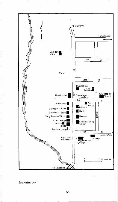
To Gunning
Lind St
David St
Post Office
® houses«
ClemengerMemorial
zzS^oseph'sJJChurch
Harp St■ Old
n House■ Library
| Bank
1 Bakery
■ Crowes Wine ™ Saloon
Morni
ng
Lot St ------
SchoolPresbyterianChurch
Gun da roo
58

W illiam Guise allegedly left France for England and then Australia when Marie Antoinette was arrested by the Paris m ob. William Guise now lies in the oldest marked vault in St John’s churchyard.
Continue on until the main road is joined by the Bungendore road on the right. T urn into this track. W hat can you see on the right? Only a ruined church, a few lumps and bumps of vanished houses, and a cemetery. This is Upper Gundaroo, still 5 kilometres from G undaroo itself, once known as Lower Gundaroo. U pper Gundaroo held the honour of having the post office, but its strength gradually waned when Lake George’s rising waters tended to divert traffic to the northern settlement. By the mid-1890s, when Upper G undaroo had lost its post office after a successful cam paign by Lower Gundaroo, it was eclipsed by its rival and even the church’s nam e was forgotten. The Anglican church, built in 1849, had been called St Philip’s. Note the hearts in the handm ade bricks and take a rubbing with paper and crayon. The church had been used as a school but had not been consecrated. In 1915 an attem pt was made to rectify this situation but the Bishop, unaware of the church’s earlier name, called it St Luke’s.
Rejoin the main road. Across the bridge over the Yass River, on the left-hand side, is the site of the Old Harrow Inn. Gundaroo residents, frightened of bushrangers, arranged for a lantern to be flashed from the inn if suspicious looking travellers were sighted. The road leads straight into Gundaroo.
Take the top off Gundaroo by exploring Cork Street. First on the left is a derelict pise" building, once a butcher’s shop. T he house nearby is the former police station and behind it stands the lockup.
Pause in front of St M ark’s Anglican Church, former court house, telegraph station and school. It was built in 1875. Can you tell what features were added before it was dedicated as a church in 1941? T he porches and the
59
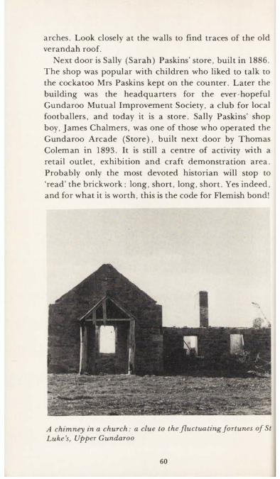
arches. Look closely at the walls to find traces of the old verandah roof.
Next door is Sally (Sarah) Paskins’ store, built in 1886. The shop was popular with children who liked to talk to the cockatoo Mrs Paskins kept on the counter. Later the building was the headquarters for the ever-hopeful Gundaroo Mutual Improvem ent Society, a club for local footballers, and today it is a store. Sally Paskins’ shop boy, James Chalmers, was one of those who operated the Gundaroo Arcade (Store), built next door by Thomas Coleman in 1893. It is still a centre of activity with a retail outlet, exhibition and craft dem onstration area. Probably only the most devoted historian will stop to ‘read’ the brickwork: long, short, long, short. Yes indeed, and for what it is worth, this is the code for Flemish bond!
A chimney in a church: a clue to the fluctuating fortunes of St Luke’s, Upper Gundaroo
60
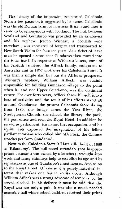
T he history of the impressive two-storied Caledonia Store a few paces on is suggested by its name. Caledonia was the old Rom an term for northern Britain and later it came to be synonymous with Scotland. The link between Scotland and Gundaroo was provided by an ex-convict and his nephew. Joseph W ishart, a Scottish wine m erchant, was convicted of forgery and transported to New South Wales for fourteen years. As a ticket-of-leave m an he opened a store near Gundaroo then moved into the town itself. In response to W ishart’s letters, some of his Scottish relatives, the Affleck family, em igrated to Australia and in 1857 took over his Caledonia Store. It was then a simple slab hut but the Afflecks prospered. W ishart’s nephew, William Affleck, was mainly responsible for building Gundaroo village to the point when it, and not Upper Gundaroo, was the dom inant centre. For over forty years, Affleck threw himself into a host of activities and the result of his efforts stand all around G undaroo: the present Caledonia Store dating from 1880, the bridge across the Yass River, the Presbyterian Church, the school, the library, the park, the post office and even the Royal Hotel. In addition he served in parliam ent. His name, first occupation, and his squint eyes captured the imagination of his fellow parliam entarians who called him ‘Ah Flick, the Chinese storekeeper from G undaroo’.
Next to the Caledonia Store is ‘Hazelville’ built in 1889 as ‘Kilamaroy’. The bull-nosed verandah (not inappropriate because it was owned by a b u tch er), wrought-iron work and fancy chimneys help to establish its age and its reputation as one of Gundaroo’s finest houses. And so on to the Royal Hotel. Of course it is purely historical in terest that makes one hasten to its doors. Although William Affleck was a strong advocate of tem perance, he served alcohol. In his defence it must be said that the Royal was not only a pub. It was also a much needed assembly-hall where school children received their prizes
61
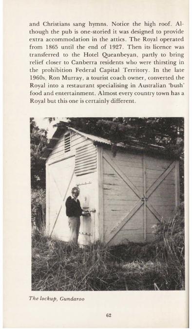
and Christians sang hymns. Notice the high roof. Although the pub is one-storied it was designed to provide extra accommodation in the attics. The Royal operated from 1865 until the end of 1927. Then its licence was transferred to the Hotel Queanbeyan, partly to bring relief closer to Canberra residents who were thirsting in the prohibition Federal Capital Territory. In the late 1960s, Ron Murray, a tourist coach owner, converted the Royal into a restaurant specialising in Australian ‘bush’ food and entertainm ent. Almost every country town has a Royal but this one is certainly different.
The lockup, Gundaroo
62

Directly opposite the Royal on the corner of Cork and H arp Streets is the Clemenger Memorial. W illiam Ralph Clemenger was a shortish man with straight, clear features. It is a pity that his dark moustache is so droopy that in old pictures it looks as though a photograph corner has slipped onto his face. Clemenger arrived in Gundaroo in 1882 at the age of seventeen as the town’s first telegraph operator. He had a great enthusiasm for writing and for organising sports and entertainm ents. Stim ulating interest in boxing, rugby union and the relatively new sport of bicycling, contributing to local concerts and helping to organise the first show, Clemenger succeeded Affleck as the King of Gundaroo.
From the Clemenger Memorial, cross H arp Street and walk by the Anzac Memorial and Affleck’s library, and the Commercial Bank. Most good history tours should include as many resting places as possible, so call in at the next building, the Commercial Hotel. It was established in 1872 by a blacksmith, Noah Cheesman, and built by his father-in-law who gloried in another Biblical name, Jerem iah Barrett. The Commercial Hotel is believed to be the oldest established wine bar in Australia. It was licensed as such by Alfred Crowe in the mid-1890s and has been run by the Crowe family ever since.
After the Commercial, cross Lot Street and walk over to the Presbyterian Church, a neo-Gothic building dating from 1864. Only its shell remains; the inside has been torn out by vandals. In its prime it was used as a place of worship for Anglicans as well as Presbyterians and was also a school. William Affleck, who promoted the building, hoped for the best. He established a trust fund to pay a minister to preach not less than once a fortnight but stipulated that two pounds would be deducted every time the minister failed to turn up. But as the years wore on no minister was readily available in Gundaroo, and Affleck, who was always willing to deliver the sermons himself, died in 1923. The church rapidly fell into disuse.
63
Until 1952, it was the custom for a Queanbeyan minister to come to Gundaroo on Sundays and ring the bell. Often he was the only one at the church but he qualified for the small stipend. Finally inflation and the pointlessness of the exercise ended even this effort.
Walk up Lot Street to the Public School on the next corner. Not all the early settlers felt that formal education was necessary for their young, an opinion which seems to have been shared by at least one teacher in the 1890s, who had the habit of leaving his pupils in charge of a senior student while he went prospecting for gold. It must have been a shock for him to return one day to find the School Inspector teaching his class.
From the school visit St Joseph’s Roman Catholic Church on the corner of H arp and Morning Streets. The foundation stone was laid in 1879. After the First Mass in 1881, the congregation was informed that the Church debt am ounted to only <£121, for which one of the faithful wrote a cheque on the spot.
It is worth crossing to the other side of Morning Street from St Joseph’s to walk by some old houses. In places the rendering has fallen off the walls, revealing early methods of building construction. A slab hut in Harp Street is falling into decay with the corrugated iron roof slipping off the shingles but if school children wanted to use a building as a model for a m iniature slab-hut construction of their own, here is a good place to start.
Stop at Gundaroo Park, another of Affleck’s achievements, at the corner of David and Cork Streets. It was here that John Clemenger, who became captain- m anager of the 1928 Davis Cup team, developed his love for tennis. Also look at the old farm buildings near the park and the home of W illiam Affleck’s parents, Camden Villa, in Lind Street on the park ’s eastern border.
64
Tours from the King’s Highway
Q ueanbeyan(Canberra Post Office to Queanbeyan Post Office, 14 kilometres.)Joseph W ild and Charles Throsby Smith came upon the site of Queanbeyan (meaning clear or running water) shortly before Christmas 1820. This discovery was all very well but the river junction at this spot was not the Mur- rumbidgee. Throsby Smith, who had been told by his uncle that the river was nearby, gnashed his teeth for having been sent on a wild goose chase and settled down to marry and to the more definite goal of raising seventeen children.
Although the sites of Queanbeyan and C anberra were discovered in the same year, Queanbeyan lay on more favourable crossroads and was quicker to develop a nucleus. Proclaimed a town in 1838, Queanbeyan became the centre of the local administrative district whereas Canberra was merely a dependent. By 1851 Queanbeyan’s population had risen to 208, in com parison with 274 at Yass and 30 at Bungendore. Like most of the colony’s towns, early Queanbeyan was well populated with sly-grog sellers. It was in an effort to stop the illegal sale of spirits, particularly rum , that an inn was licensed in 1838. The random stone building is now a private residence near the corner of Hazel and River Streets on the Oaks Estate, a small settlement close to Queanbeyan but still within the borders of the ACT.
Continue to the centre of Queanbeyan and cross the river to the streets on the eastern bank. Some of the first houses in Dodsworth Street were occupied by Irish em igrants and the area became known locally as Irishtown.
65
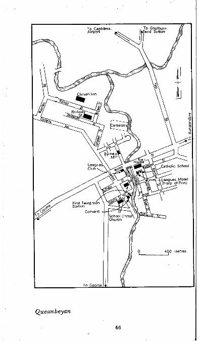
Elmsall Inn
.Catholic School
Leagues Motel " larp of Erin)
First Telegraph Station
ConventSchool Christ\ Church
400 metres
To Cooma
Queanbeyan
66
Dodsworth House (now demolished) was built in 1838 as the residence of the first police m agistrate, Captain Alured Tasker Faunce.
The early inhabitants of a village sometimes show a strange inclination to settle on the most uncom fortable sites and to return to them time and time again in spite of predictable disasters. And so it was with Q ueanbeyan’s residents. They clustered on the river’s east bank, a handy spot for drawing the daily water but a most inconvenient place to be when the river flooded. Trinculo Place, the site of the town well, was repeatedly under water. The floods often covered the river end of Macquoid Street which was originally Q ueanbeyan’s m ain thoroughfare. W hen the construction of St Gregory’s Rom an Catholic Church began in 1849 on the corner of M acquoid and Molonglo Streets one comforting thought was that the church would be a welcome refuge if ever the waters reached this far.
Flood threats did not deter the citizens from concentrating many of their activities in the area. The present- day Kent Private Hotel was built on the corner of Trinculo Place and Macquoid Street in the same year as St Gregory’s and at different times served as a court house, a bank and a hospital. The Leagues Motel in Macquoid Street stands on the site of the H arp of Erin Inn, opened in 1853. The Harp of Erin was a central m eeting place where nineteenth century residents discussed matters close to their hearts including the abolition of convict transportation and the establishment of annual horse races.
Cross the Queen’s Bridge again to west Queanbeyan. This was the first bridge of any appreciable size in the district and its construction in 1857-8 caused trem endous excitement with police firing a salute as each pile was driven in. It has been replaced several times, most recently in 1973. The Leagues Club in Monaro Street was first opened on that spot in 1965, was burn t down, bu t re-
67

emerged in even grander form in the 1970s. Nearby, J. B. Youngs and the former Woolworths occupy the sites of two of Q ueanbeyan’s earliest stores. By the 1860s Monaro Street was recognised as the main business centre and many of the town’s most substantial buildings were erected on the west rather than the east side of the river.
The stone section of the schoolhouse in Rutledge Street dates from 1843 while the original Anglican Christ Church was consecrated by Bishop Broughton on 8 March 1845, four days before he performed the same ceremony at St John’s, Canberra. Fifteen years later the present stone church was erected, with its characteristic rounded arched windows designed by the Reverend Alberto Diaz Soares. Of Portuguese descent, Soares sailed from Southam pton to Australia in 1852, arriving on the seventy-fifth day out, the quickest passage then known. His brother, Gualter, taught at Christ Church school and helped with ecclesiastical duties, bu t more than one suspicious eye brow was raised in his direction when the rum our went around that he was a form er smuggler.
The Methodists, exceptionally active for a small group, built a church in Rutledge Street in 1859. In parallel Isabella Street the Sisters of the Good Sam aritans founded St Benedict’s Convent in what was formerly the telegraph office, and in March 1879 the Convent ‘High School for Young Ladies’ opened its doors to five pupils at No. 7 M acquoid street. The present convent dates from the 1880s. Excellent scholars can come from the smallest of schools and the first boarder, Sarah Octavia Brennan, later became the first Catholic woman to graduate as a Master of Arts from Sydney University.
Another denom ination, the Presbyterians, built St Stephen’s in 1874 and a manse in 1883 in Morrisett Street. T he bricks were some of the first to be m ade by machine instead of by hand in southern New South Wales. At the foot of Morrisett Street, by the river,
68
m arket gardens were established by Chinese, who had been drawn to the area by goldrushes at Braidwood and Kiandra. Byrne’s Steam Flour Mill, in Collett Street, now a craft and entertainm ent centre, was built in 1883. Also by the river, a little further north, is the old Queanbeyan cemetery. Its location was not ideal. In time of flood, some form er residents were precipitated into a watery grave.
B ungendore(From Canberra Post Office to Bungendore Post Office via Queanbeyan, 39 kilometres.)Bungendore was officially proclaimed a town in 1837. It was a mere speck in the new Queen Victoria’s empire and not m uch more noticeable in a colony absorbed in the great debate over the abolition of convict transportation.
Nevertheless, it had the supreme distinction of being the oldest settlement directly south of Lake George. It benefited from its location at the junction of the Queanbeyan, Goulburn and Braidwood roads. The Queanbeyan road, east of today’s highway, was convict- built. The G oulburn road was a major link with Sydney but a considerable am ount of traffic also came on the Braidwood road in the pre-railway days when stores were sent by sea from Sydney to Batem an’s Bay and then hauled inland by bullock waggon. The old police barracks stand at the junction of Molonglo and Malbon Streets, where most tourists turn right to go to the coast. The white two-storied building bears the date 1864 and was one of the first substantial structures built in a town renowned for sly-grog selling.
T urn ing down Malbon Street, note the variety of architectural styles. First on the right there is a neatly executed home of sandstone, a m aterial m ore reminiscent of Sydney than of this area, although it is also used to good effect in Bungendore’s court house. Further down, on the corner of Malbon and Ellendon Streets is the
69

To Goulburn
T u rra llo Terrace
Old coaching
ToCollector Rabbit Free:
Works ruinand Lock up
Lake Ge Federal HWY
Police and Court house
Malbon To Cemetery
200 metres’
’To Canberra
B ungendore
70
Carrington with its wrought-iron lace work still in good condition. It was built in about 1889 by W illiam W inter who baked 20,000 bricks in a hand-m ade kiln. The Carrington had a hotel licence until the late 1890s, when it became Bungendore’s general store, then a house and later a num ber of flats. The A ntique Shop on the diagonal corner was built at the end of the first world war.
On the corner of G ibraltar and Butm aro Streets is St Philip’s Church of England, opened in 1865 replacing an earlier brick church. The similarity of St Philip’s to the extension of St John the Baptist, C anberra, is unm istakable and, indeed, they were both designed by the same architect, A. D. Soares who was also active both arch itecturally and ecclesiastically at Queanbeyan and Car- woola. In the small Bungendore community, weddings were conducted with great pomp and ceremony. The m ain district newspaper, the Queanbeyan Age carried one ecstatic description after another of marriages in St Philip’s. On these occasions, the church was converted in to a bower of ferns, chrysanthemums or roses with an arch over the communion rail, of ferns and flowers, from which hung a huge white wedding bell.
Although the Anglicans opened the first church, the Roman Catholic community was strong as many residents were of Irish descent. In 1853, when Bungendore’s population had reached seventy, Rom an Catholics founded the first school. In 1861 St Mary’s Church was begun on the com er of Ellendon and Turallo Streets and in 1888 St Joseph’s Convent was established, first near St Mary’s, and later on its present site on the corner of Turallo and Butmaro Streets. The central portion of the Convent belongs to the 1890s; the external archways date from the early 1930s. W hen it was built, the Convent was a massive landm ark on the wind-swept plain. It was indeed the purpose of Mary McKillop, founder of the order of St Joseph, to bring the C hurch to small rural
71

communities. M other Mary of the Cross (1842-1909) encountered considerable opposition in pursuit of her aims, including being excom m unicated by the Bishop of Adelaide, but in the 1970s she was being considered for the honour of Sainthood.
In G ibraltar Street, the Anglican school dropped its denom inational status in 1868 and became Bungendore’s first Public School. W alking up and down the streets, one soon notices that the roads lie in a grid pattern, ven
A delicate handkerchief for a bullnosed verandah roof, Gibraltar Street, Bungendore
72
much in accordance with Governor Darling’s planning regulations of 1829 which had been designed to ensure uniformity and set sizes for allotments.
Bungendore was a planned town but even ‘the best laid schemes o’mice an’ men Gang aft a-gley’. During coaching days, St John’s Presbyterian Church was built on a slightly elevated eastern site near the Braidwood road but when Bungendore was surveyed for a railway, the church was found to be in the middle of the proposed line. T he railway took precedence over the church which was demolished in 1883 and re-built on its present Butm aro Street site.
Bungendore’s foremost industrial site is in G ibraltar Street. A concrete block was once the site of the flour mill, saw mill and the rabbit freezing works. R abbit and hare hunting had always been a popular local sport. In 1899, at a hare and wallaby drive held at the R utledge’s property, Gidleigh, 211 hares and 79 kangaroos, w allabies and rabbits were shot.
But rabbits were also a commercial enterprise. Ebb and Ross Brown of Hall would buy as many as seven hundred pairs of rabbits each week and take them to Queanbeyan to be railed to Bungendore. At the time of the first world war, the cannery, operated by Messrs Curtis and Curtis, exported tinned rabbit m eat. Bungendore’s volunteers, sitting in the dam p trenches in France, were able to enjoy home-grown rabbit stew.
73

Tours from the Barton Highway
St N in ian ’s Presbyterian (Uniting) Church(Corner of old Barton Highway and Brigalow Streets, Lyneham.)Scotsmen who had come to Canberra with their families to work as shepherds and farm hands were among those who most warmly welcomed the opening, in 1863, of a Presbyterian Church. It was the first of this denom ination, not only in Canberra, but also in the entire Queanbeyan district. Previously Presbyterians had worshipped in St John’s Schoolhouse but when fiery words and actions were exchanged fretween a num ber of dissenters and the schoolhouse’s owner, George Campbell, the Presbyterians moved into their own modest slab and bark building. The present stone church, begun in 1873 and subsequently extended, was built nearby. After a history of fluctuating congregations and decay, the church was restored in the 1940s and nam ed St N inian’s after a Briton trained in Rome who was sent to convert pagans in Scotland.
T he Old Canberra Inn(Barton Highway, Lyneham.)Beer is still served at one of C anberra’s oldest inns, the third to be licensed, if one counts the Elmsall on Oaks Estate and the Cricketers Arms, sometimes called the One Tree Hill Hotel, near Hall, as num bers one and two. Built in the 1860s and licensed in 1876, Joseph Shum ack’s Canberra Inn, a coaching stop on the Yass to Q ueanbeyan route, traded until 1887. It later became a house known as The Pines but was licensed again in the 1970s. T he ceiling shows that the renovations have been ex-
74
tensive but the character of the old split logs, both in the m ain bar and in the stables outside has been retained.
Gold Creek Homestead(Gold Creek Road, Ginninderra.)W hen Gold Creek was named, it was more a m atter of wishful thinking than proof of m ineral wealth. A lthough Edm und Rolfe, who lived there for over half a century, would have been grateful for a pot of gold to help support his fourteen children, he made a satisfactory living from sheep, wheat, horse-breeding and from carting goods including the stones for St John the Baptist’s new tower. His racehorses, particularly one called Gold Creek, galloped past the winning post sufficiently often to be a better source of investment than the Hall Gold and Copper Mine.
It is not known precisely when the original slab hu t was built at Gold Creek but it was inhabited by the early 1860s. T he cottage knew an early sorrow. E dm und’s wife died in childbirth with her fourth baby. He m arried again, this time to M argaret Keefe who had created a fuss in the district by running away the night she was to be m arried to her form er fiancd. The Rolfe family expanded to a happy combination of seven sons and seven daughters. Many of the children slept in the roof and at night were no doubt entertained with stories of their distant relative John Rolfe who m arried the Am erican Indian Princess, Pocahontas. The cottage still has three of its original walls, the Rolfe’s fireplace and their pantry shelves in the kitchen.
GinninderraOf all C anberra’s present residential areas, G inninderra can claim to have had the most clearly developed village centre in the nineteenth century. It was settled early in the district’s history. George Thom as Palm er, who had fought in Egypt at the time of Horatio Nelson’s Battle of
75

the Nile, ‘squatted’ at G inninderra (then spelt Ginin- derra) Creek about 1826. The first settlem ent was often referred to as Palmerville but the Aboriginal nam e Ginninderra eventually gained precedence. The district received a boost in the 1860s when a num ber of small holdings were taken up after the Robertson Land Acts were introduced. The population was less than half the size of Queanbeyan or Bungendore, but its sporting achievements put the village well and truly on the map. The G inninderra cricket team , at its best when captained by the ‘squire’ William Davis, was acknowledged to be the finest in the colony. Pigeon shooting was also popular. By contrast, there was the gentler activity of the storekeeper, George H arcourt, who took an interest in the Acclimatisation Society and is reported to have tried to make twenty-one English skylarks take to the Australian bush.
G inninderra declined when the Commonwealth government resumed land for the Federal Capital T e rritory. Many of the district’s leading families including the Rolfes of Gold Creek and the Ryans of Horse Park left rather than accept a lease of their form er freehold property.
W ith a M ounted Constable and his assistant black- tracker on duty from the 1880s, G inninderra had the most obvious show of law and order in Canberra. The lockup, built in 1905, is on the Barton Highway, on the opposite side of the road to the schoolhouse, about one hundred metres back towards C anberra. It is out of sight of the road and is on Commonwealth property but it is accessible with the permission of the tenants of the w eatherboard house. The gaol’s hatch through which the prisoner, usually a drunk, could be observed and given food is similar to the hatches of the G undaroo and Bungendore lockups (the latter was demolished in 1979).
G inninderra Schoolhouse turn-off is on the eastern side of the Barton Highway approxim ately 1 kilometre past
76

the bridge over G inninderra Creek. Back towards C anberra about one hundred metres the dilapidated corrugated iron shed was the blacksm ith’s shop, which was especially im portant to the community after the middle of the nineteenth century when horses replaced bullocks for ploughing.
Next door to the G inninderra Public School and Residence is a building in heavy disguise. The stone St Francis’ Roman Catholic Church, where many of the Rolfe children attended both church and school, is now part of a house.
The G inninderra Public School and Residence, begun in 1883, was opened the following year. There had been schools in the area before but education was largely hit- and-miss. Even if children stayed at school until they were fourteen years old, they often missed weeks of classes during the ploughing and harvest seasons. The new stone school, with the windows in the single classroom set high to prevent the pupils from being distracted, had a no- nonsense air about it and was attached to the schoolmaster’s residence. But at first it was only halftime. The schoolmaster divided his attention between Ginninderra and Gungahlin, back towards Canberra. G inninderra became full-time in 1906 but five years later it was closed because most of the pupils were living in Hall.
Next door, the G inninderra Schoolhouse R estaurant serves afternoon tea at the weekend and dinner from Thursday to Saturday. The slab cottage was brought from Gunning and re-erected in 1973. Like the Old C anberra Inn, it is a cosy slab building where one can warm one’s toes by an open fire.
Hall(From Canberra City Post Office to Hall Post Office, 18 kilometres.)The small settlement to the north-west of C anberra came
77

To Murrumbateman and Cooma Cottage
\ Within 2km to \ St Francis Xavier Church \ pise house and
\ \ \W attle Park Church
Original school building
St Michael s and All Angels Church
Bootmaker
Hall Service Station ^ ^ (w h e e lw rig h t and coachbuilder) ^ ^ A n tiq u e Shop (Kinlyside Hall)
R.H Brown Premier Store
To Cemetery
\ \Q Post and rail fence and V ^commemorative plaque
250 metres
To Canberra
H a ll
78

to be known as Hall after the owner of Charnwood property. Henry Hall arrived in Australia from Loughborough, England in 1823. The following decade he took up his grant where he and his wife raised ten children. Henry Hall became one of the Queanbeyan district’s first magistrates. T he names of Hall’s streets provide a clue to the period of the village’s development. The first southern streets, for example, are called Victoria and Gladstone.
Entering Hall from Victoria Street, the sports ground is on the im m ediate right, bordered by a good example of post and rail fencing. Measure the lengths of the rails. Two rails, with their middle overlap, should measure about 16.5 feet, or 5 metres. This was the length of the rod, the measurement by which fencers were usually paid for their work. Directly inside the fence, notice the small brass plaques fixed onto the posts beside the trees com m em orating those local men who enlisted in the first world war. T he plaques to the two men killed in action are on either side of the gate.
Continuing up the right-hand side of Victoria Street, note the long building now called Hall Antiques. This was Kinlyside Hall and has been used as a dance hall, a church, and a cinema in the 1920s and 1930s. The man who built the hall, George Kinlyside, was famous for inventing the Kinlyside Poison Cart (or Patent Pollard D istributor), which made furrows and dropped phosphorus and pollard baits to kill rabbits. A little further up is the Hall Service Station where George Kinlyside commenced business in 1898 as a wheelwright and coachbuilder. Later he conducted a hire-car business with his pride and joy, a Model T Ford.
A nearby building was once owned by a bootm aker. He had two halfpennies stuck some distance away from each other on the counter to show customers the size of his largest order, which he claimed were the biggest boots
I ever made in the state.
79

The bell swinging from a stand in front of St Michael’s and All Angels formerly rang at St John the Baptist, C anberra. The foundation stone of the Hall church was laid in 1941, the year of St Jo h n ’s Centenary and the church was built by an exceptionally tall (211 cm) Englishman, M artin Midmer.
The old bell from St John the Baptist’s, now at HallOn the left-hand side of the road the present Store was
erected in the early twentieth century, although there was trading near this site from the late 1880s when goods were brought from Queanbeyan by bullock or horse-team. Inside the shop there is a long counter and floor-to-J ceiling shelves, the highest of which can only be reached by a ladder. The tem pting smell of hot m eat pies wafts into the post office, at the back of the shop.
The blue-stone St Francis Xavier’s Rom an Catholic Church replaced the church at G inninderra in the early! twentieth century. Most of it was built by volunteers on an excellent location overlooking the Murrumbidgeej
80

The descendant o f a prom inent pioneering fa m ily : Miss Jean Southwell m ixing milkshakes in the H allstore, 1979
81

hills. Across the ACT-NSW border on the C anberra side of W attle Park C hurch and on the same side of the road as the Church are the substantial ruins of a pise/ cottage, formerly owned by the builder of Hall School, George Morris. This cottage is said to have been struck by lightning. W attle Park Church is intimately connected with the Southwell family. W hen Thom as Southwell and his wife decided to leave England they were ready to embark on the first available ship, whether it was bound for America or Australia. An A ustralian-bound ship happened to be in port and the Southwells finally m ade their way to the G inninderra-H all district, bringing with them their staunch Methodism, which culm inated in the opening of the church in 1882. T he Southwell’s property, Parkwood, may soon be opened as a tourist centre.
Hall Cemetery(From Canberra turn left into Gladstone Street and right into Wallaroo Road. A short track on the right leads off Wallaroo Road to the cemetery.)One rem arkable feature of the cemetery dedicated on 22 M arch 1883 is the longevity of the people buried there. Relatively few headstones record a death under sixty-five and when they do, it is often a story not of a disease, but of an accident. This was so in the case of Ernest W. Gribble who was crushed to death at the age of twenty- four when he fell into the fly-wheel of a traction engine. Some of the older inhabitants also died painfully. In August 1927, seventy-four-year-old Jacob Blundell, the brother of George who lived at Blundell’s Cottage, Canberra, was suffocated and seared when his bedroom caught fire.
Continuing on the highway to M urrum batem an note the sign ‘Gooromon Ponds’. It was probably from this area that the first white explorers saw the Australian Capital Territory.
82
M urrum batem an(40 kilometres from Canberra.)M urrum batem an owes its origins to a wrong being put right. ‘Granny Davis’ received a grant of land as compensation for being unfairly convicted of stealing a gold watch, for which she was transported to the colony.
T u rn up Dog T rap Road on the left from Canberra and at the first bend look for a sign on the road pointing to the cemetery. Unlike old and crowded graveyards M urrum batem an cemetery has clear divisions between denom inations.
The bull-nosed M urrum batem an Post Office on the Barton Highway was once the M urrum batem an Hotel and m any a beer has passed across its counter. The Union Church also on the Highway was an early ecumenical venture by Anglican and Presbyterian families. It lasted from 1876 until the end of the first world war. Then the Anglicans erected, in the middle of the village, the All Saints’ Soldiers’ Memorial Church of England, with its distinctive square tower and window bosses.
The first school was opened at M urrum batem an in 1869. Rebuilt and refurbished many times, the present building on the Highway is one of the finest in M urrum batem an, bu t it closed its doors to pupils in 1972. A little further on, note the slab residence which is still occupied.
Cooma Cottage(At the junction of Barton and Hume Highways. 60 kilometres from Canberra.)Cooma Cottage is situated near the Yass River where the explorers Ham ilton Hum e and W illiam Hovell m ade cam p on their southbound expedition of 1824. An early Yass settler built a house on the spot in 1836 and later Ham ilton Hume returned to live there. He built the brick extensions and the stables in about the 1840s. The round openings in the stable walls allowed owls to fly in and
83
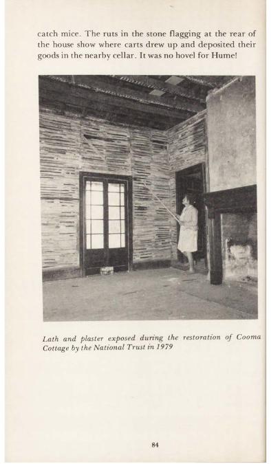
catch mice. T h e ru ts in the stone flagging a t the rea r of the house show where carts drew up and deposited their goods in the nearby cellar. It was no hovel for Hume!
Lath and plaster exposed during the restoration of Cooma Cottage by the National Trust in 1979
84
Tours from the Monaro Highway
E nvirona(From the Monaro Highway, pass under the railway bridge near the Tralee National Speedway. Turn hard right and follow the railway line for a few hundred metres. The property is not open to the public.)At Environa, one can see the stone remains of a bright idea. W hen the Commonwealth government resumed all the land in the Federal Capital Territory in 1915, a Sydney m an, Henry F. Halloran, decided to establish a town called Environa, just beyond the T erritory’s borders. T he town’s location meant that its future inhabitants could own their land instead of leasing it and still live close to the national capital. W ith this incentive he even m anaged to attract potential buyers from England.
W ithout trespassing on the property, look at the stone arch at the entrance to the estate and a column supporting a bust of Sir Henry Parkes, the father of Federation. The town was to be built on a radial principle, similar to some of W alter Burley Griffin’s designs, and the streets were to bear names from around the world: Piazza di Roma, Rue de Paree, Tokio Dora, Estrada Lisbon. H alloran’s grand schemes were nipped in the bud by the Depression of the 1930s. Though the bandstands can still be seen today, they never rang to the joyful music of happy freeholders.
Sacred H eart C hurch , T uggeranong(Tharwa Road, Tuggeranong, on the left-hand side from Canberra.)The land on which this isolated Roman Catholic Church stands was the gift of James Cunningham to Father
85
Collender of Q ueanbeyan. Father O ’Gorman from Michelago celebrated Mass at the opening of the w eatherboard church on a w inter’s day, 29 June 1902. Perhaps it is not surprising that one of the parishioners’ first projects was to plant the grounds with pine trees. For many years Sacred Heart was the scene for wonderful Sunday picnics, interspersed with church services.
L am brigg and the F a rre r M em orial(On the Murrumbidgee River near Point Hut Crossing. The property is not open to the public.)Lambrigg (a W estm orland nam e m eaning ‘the hill of the lambs’) was the home of the district’s most renowned agricultural scientist, W illiam James Farrer.
Farrer was a relative newcomer to C anberra, not having arrived in Australia until 1870, but it was not long before he was well known as the tu tor to George Campbell’s children at Duntroon. He later m arried Nina, the only daughter of Leopold De Salis of Cuppa- cumbalong. In his experim ental paddock and pise laboratory Farrer developed a strain of wheat resistant to rust (a powdery red fungus). His work was a m ajor contribution to wheat-farming.
Before he died, Farrer m arked the spot on his property where he wished to be buried. W hen the time came on 16 April 1906, men began to dig at the nom inated place but soon struck rock. Although they hoped to inter Farrer at 2 pm, it took twelve hours blasting to excavate the grave, and he was not buried until 2 am.
Lanyon(Tharwa Road. Open 10 am to 4 pm Tuesdays to Sundays and on public holidays.)A death occurred at Lanyon in 1837 well before the present homestead was built. One of the three young English owners, William W right, was accidentally shot getting out of a log canoe and died after several days of
86

agony. He was buried on the property but to ensure that dingoes did not disturb his body, the coffin was packed in with heavy stones. His brother, James, took over his share as well as that of their friend, James Ham ilton Mortimer Lanyon, who returned to England but left his name behind.
Lanyon becam e a self-contained community. In the absence of a nearby church — for even St John the Baptist had not yet been built — a m arriage ceremony was perform ed there in 1842. It amazed the Aboriginal onlookers who were surprised that white people invested such a trivial m atter with so m uch im portance. The property had a blacksm ith’s shop, m eat house and dairy, store rooms, coach house and stables, a private cemetery and later even a post-office. The convict gaol, with iron rings for chains, lies across the paddocks from the present driveway.
Under Andrew Cunningham, who bought Lanyon in 1847, and his sons, who took over after his death, the property gained a reputation for innovation and elegance. Andrew Cunningham Senior first introduced fencing, elim inating the need for shepherds and sheep- folds. Candlelit meals and dances on polished floors were held in a new homestead, built in 1869. Lanyon now houses a collection of Sidney Nolan paintings, m any of them of Ned Kelly.
T h arw a(Turn off about 30 kilometres along the Monaro Highway. Tharwa is about 10 kilometres from the turnoff)T he bushranger John T ennant would no doubt have been pleased if ever an entire settlement had lain at his feet. Denied this, he at least had the posthumous pleasure of having the m ountain which dominates Tharw a named after him. T ennant made many forays from his m ountain hide-out including a raid on the overseer’s hut at Dun-
87
troon from which he stole, am ong other items, James Ainslie’s nightcap. Although T en n an t’s pickings were generally petty, he often threatened violence. He was finally captured in 1828.
Tharwa was given in 1882 that all-im portant m ark of civilisation, a post-office, but it was always a tiny settlement. T he 1891 census showed that there were only thirty-eight dwellings and 255 inhabitants. Not included were twelve Aboriginals. Nor does one read m uch about Aboriginals in other records, although Q ueanbeyan’s Queen Nellie was a celebrity. Old Timers rem em ber her greeting them at the opening of T harw a’s famous truss bridge in 1895 and being surprised to find that her hands were soft.
There was a public school at Tharw a from the late 1890s but it was half-time until 1905. The present school was built in 1912 and boasts a bell from the old Tuggera- nong school. Part of the Tharw a school’s playground is said to have been an Aboriginal cam ping ground. St Edm und’s Church of England was built during the first world war and dedicated on 7 May 1919.
88
Tours from the Captain’s Flat Road
St T hom as’s C hurch , Carwoola(Travelling from Canberra, the turn-off to the Captain’s Flat Road is about 4 kilometres from Queanbeyan on the right-hand side of the Highway. The church is approximately 13 kilometres from the turn-off and is on the left-hand side of the Captain’s Flat Road.)Designed by A. D. Soares and opened in 1874, St T hom as’s is one of the largest Anglican Churches in the district. It was built by W illiam Follett, who is buried in the cemetery nearby.
C ap ta in ’s Flatj . (Canberra Post Office to Captain’s Flat, 33 kilometres.)
C aptain’s Flat was named, so it is said, after a bull called C aptain who grazed in one of Foxlow’s southern paddocks. C aptain’s level pasture was unusual because the surrounding country was hilly, good for shelter, as outlaws found, and even better for minerals as prospectors discovered.
As the story goes, men digging the grave of an employee on one of the local stations found a metallic substance which everyone hoped was gold. By the 1880s, sufficient lodes of copper, silver and gold had been found to make C aptain’s Flat a boom town. Though small partnerships were satisfactory for gold-mining, they had less success with copper which required more sophisticated techniques. It was not long before larger pro-
I prietors stepped in. Of the two substantial new mines established in 1886, the first was called El Capitan. Captain the bull would no doubt have appreciated the Spanish allusion. The second was Ko-i-noor, a name

Hospital
Newtown
Bell Tower *Catholic
^■ C hurchschool
(School/buildingsConvent
To -3 —- Canberra M ontgom e ry
IChurch
Mines and quarry
Bank
To Mines Post Office
Bogtown
ToBra id wood
To Cemetery
To Cooma
90
Captain ’s Flat

derived from that of an enormous diam ond. The subsequent story of the companies is complicated but, in brief, El Capitan was mismanaged and gave way to the Commodore Vanderbilt which operated until 1896. Then Commodore Vanderbilt combined with Ko-i-noor to form the Lake George Mining and Smelting Company which worked the ore until 1899. There were many byways to the transactions but the general move was towards consolidation.
The population of C aptain’s Flat leaped from 104 in 11886 to 650 in 1889 and to 1700 in 1897. Perhaps leaped is the wrong word: many of the new inhabitants trudged from as far away as Braidwood looking for work. In the township of C aptain’s Flat men outnum bered women by a hundred or more and there were always a few Chinese.
The initial group of buildings, little more than hessian shelters, huddled in a low-lying area and became known as Bogtown. It was only after the second world war that the nam e was changed to ‘Oakvale’. Newtown, which became the main residential area, developed on a low hill. As in all m ining towns, the pubs flourished, glorying in a drink called skunk, a mixture of rum and orange. The bar in the present C aptain’s Flat Hotel, built in the 1940s, was reputed, at 33.3 metres, to be the longest in Australia.
In the mines there was sometimes trouble between the m anagem ent and unionists. In 1891 the m anager of Commodore V anderbilt broke up the local carriers’ union and employed non-union carting teams. Shortly afterwards, three working bullocks owned by a widow, Mrs E. Harrison, were shot by persons unknown. But the motive was believed to be revenge because the bullocks were used by Mrs H arrison’s non-union sons to draw coke to the Commodore Vanderbilt mine.
In spite of occasional discord there was no unem ploym en t and by the 1890s C aptain’s Flat was a fully-fledged town. Residents had their own newspaper and were
91
proud to have one of the first telephones installed in the Queanbeyan district. Children were taught in the present Library-K indergarten building of C aptain’s Flat School, constructed in 1889. Residents roller-skated on a fine rink, and enjoyed billiard saloons, a skittle alley and Cooper’s dance hall.
In 1899, C aptain’s Flat became worked up over the Federal Convention Bill. Those in favour held a torchlight procession on voting night singing the old American ballad, ‘H urrah , hurrah , for the Flag that set us free’. Despite this fervour, C aptain’s Flat voted against the Bill. T he same year, 1899, the town’s bubble of prosperity burst. Copper, which had long replaced gold as the most im portant m etal, became uneconomical to smelt because of the large quantities of lead and zinc found in the ore. There was very little work over the next few years and finally the crunch came. James Hickey, a fitter who repaired burst pipes, was there: ‘The last shift at the mine was a Sunday m idnight shift in 1902 and we came up on M onday m orning to be greeted by the bosses, all toffed up in their suits, to tell us we were dismissed.'
Hope sprang again in 1937 when Lake George Mines Pty Ltd began mining, using new techniques. After much stopping and starting and huffing and puffing, the railway finally came through from Bungendore in 1941. A peak year in C aptain’s Flat’s history was 1950 when 185,200 tons were milled, and valued at over two million pounds.
But boom years like 1950 were not enough to secure the town’s future. By the end of the decade the ore deposits had been depleted and further exploration proved fruitless. Talk of im m inent closure brought dismay and nostalgia and virtue was seen in even the town’s most u n lovable characters — including Billy the Bag Snatcher who had been heavily fined for eating his neighbour’s guinea-pigs.
92
W hich C anberra church was once a railway station? W ho is the famous bushranger associated with Lake George? How did C aptain’s Flat get its name? W ho sang the N ational A nthem at the opening of Parliam ent House? This book will answer these questions and m any more for everyone interested in the history of C anberra and the surrounding area. As well as descriptions of tours to places of historical interest there are many useful hints for the am ateur historian, including chapters on recognising local styles of architecture and discovering history from graveyards.
Canberra Companions are published by the Australian N ational University Press as a contribution to the cultural, educational and recreational life of the im m ediate area served by the University. Titles available inc lude:
Tales and Legends o f Canberra Pioneers by Samuel ShumackEpisodes o f Old Canberra by Ged M artin Street Trees in Canberra by Audrey H. Edwards Undiscovered Canberra by Allan J. Mortlock and Bernice AndersonBeyond the Cotter by Allan J. Mortlock and Klaus HuenekeIndolent Gardening by Libby Smith with illustrations by W inifred M umfordNative Gardens in Canberra by G. A. J. Butler Rambles around Canberra edited by Allan J. Mortlock and Gillian O ’LoghlinThe Australian N ational University — People and places in a landscapeCanberra's Embassies by Graeme Barrow Fishing around the Monaro by Douglas Stewart The Canberra H andbook
Australian N ational University Press Canberra ISBN 0 7081 1943 3