history repeats itself: the “rush” for metallic minerals ... update... · history repeats...
TRANSCRIPT

History Repeats Itself: The “Rush” for Metallic Minerals in California With the skyrocketing prices of gold, silver, iron, and other metallic minerals, combined with new, more efficient mining technologies, California is seeing a great deal of renewed interest in mining for these valuable commodities. Perhaps it’s not the frantic pace of the ‘49er days, but Lead Agencies are being flooded with inquiries into the requirements to carry out gold exploration as well as to re-open historic mines or permit new mining operations. From the Oregon border to the “Mother Lode” region to the Mojave Desert, OMR is reviewing reclamation plans from operators in search of profits from mining precious and industrial metals. For today’s miners, SMARA has replaced the Colt .45 as the law of the
land. Ghost Towns Coming Back To Life Some of California’s historic mining districts, complete with their once bustling “ghost towns,” may be coming back to life, and California may be on the verge of a new version of the “Gold Rush.” As new projects are permitted in these areas, many of the legacy features of abandoned mines – such as
Inside this issue:
Meet The New Reclamation Unit Staff
2
Protecting Water Resources One Mine At A Time
3
New Amendments To The Surface Mining and Reclamation Act
6
SPOTLIGHT: Introducing Mines On Line
8
The Quar t e r ly News le t t e r o f t he Depa r tmen t o f Conse rva t i on , Of f i ce o f M ine Rec lama t ion
January - Mar ch SPR ING 2007 Page 1 , Vo l . 11 , No . 2
Page
(continued on page 4 )
Oc tobe r - December Fa l l -W in te r 2011 Page 1 , Vo l . 15 , No . 3
Mining history comes to life in Calico Ghost Town, once a colorful mining camp and now a San Bernar-dino County Park.
Photo by Leah Gardner

Oc tobe r - December Fa l l -W in te r 2011 Page 2 , Vo l . 15 , No . 3
Meet The New Reclamation Unit Staff
Molly Ferrell joined the Office of Mine Reclamation (OMR) staff in November 2011 as an Environmental Scientist. She grew up in Seattle, attending Ballard High School and the University of Washington. Molly moved to Brooklyn, NY in 1995 where she made pizzas and deejayed at CBGB’s, coordinated tastings at Wine Spectator, and gardened at the Queens Botanical Garden. From there, she moved to Sacramento to attend University of California, Davis, receiving her master’s degree in biogeography in 2007.
Her research interests involve habitat conservation and restoration. She loves to backpack and observe the tiny world of insects, especially native bees. Last summer, Molly mapped meadows with a small team of botanists and hydrologists in Sierra Nevada forests for the Center for Watershed Sciences, and also conducted geographic information system analyses for an economic study in the Delta (the analysis and maps were used for a report generated for the Public Policy Institute of California).
Sharonjit (Sharon) Grewal joined the OMR staff in December 2011 as an Associate Environmental Planner. She garnered a bachelor’s degree in Public Administration, an Urban Studies minor from California State University, Fresno, and a Land Use and Environmental Planning Certificate from the University of California, Davis. In order to balance school curriculum, Sharon presided as president, senator, and treasurer while in college. After completing her education, she became an Environmental Planner with the State of California. For the last six years she has protected farmland by interpreting the Williamson Act for the Division of Land Resource Protection. Prior to joining
state service, she worked for the Fresno County Public Works and Planning Department. An avid sports fan, Sharon enjoys an occasional round of golf, boxing in the ring, watching football (rooting for the 49ers and Fresno State Bulldogs), and basketball. Not a surprise since she was on the basketball, swimming, and tennis teams in high school. Always active, she was also involved with the Future Farmers of America with three hog projects, and projects with rabbits and chickens. Sharon’s current passion is travel having recently visited Mexico, Singapore, and Malaysia. Currently, she is planning her first trip to India.
Oc tobe r - December Fa l l -W in te r 2011 Page 3 , Vo l . 15 , No . 3
Protecting Water Resources...One Abandoned Mine At A Time
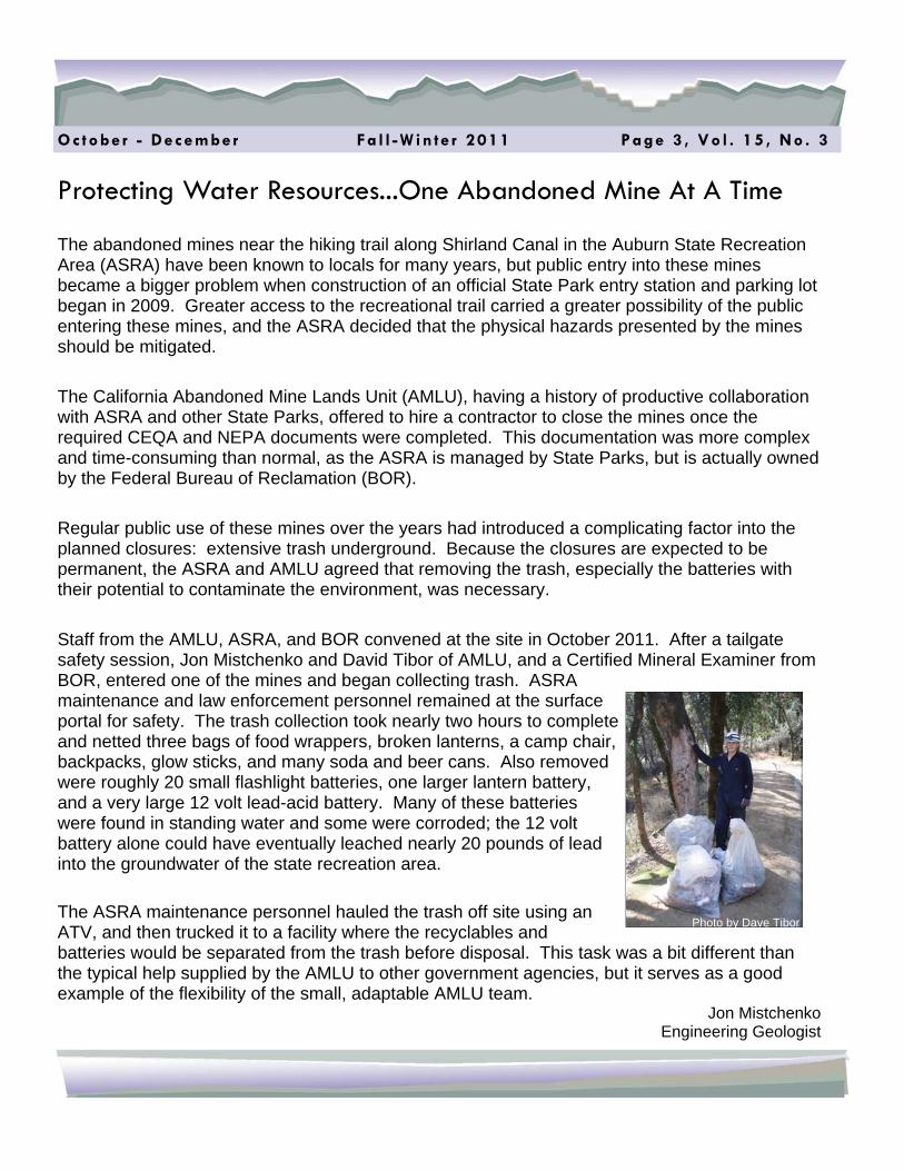
The abandoned mines near the hiking trail along Shirland Canal in the Auburn State Recreation Area (ASRA) have been known to locals for many years, but public entry into these mines became a bigger problem when construction of an official State Park entry station and parking lot began in 2009. Greater access to the recreational trail carried a greater possibility of the public entering these mines, and the ASRA decided that the physical hazards presented by the mines should be mitigated.
The California Abandoned Mine Lands Unit (AMLU), having a history of productive collaboration with ASRA and other State Parks, offered to hire a contractor to close the mines once the required CEQA and NEPA documents were completed. This documentation was more complex and time-consuming than normal, as the ASRA is managed by State Parks, but is actually owned by the Federal Bureau of Reclamation (BOR).
Regular public use of these mines over the years had introduced a complicating factor into the planned closures: extensive trash underground. Because the closures are expected to be permanent, the ASRA and AMLU agreed that removing the trash, especially the batteries with their potential to contaminate the environment, was necessary.
Staff from the AMLU, ASRA, and BOR convened at the site in October 2011. After a tailgate safety session, Jon Mistchenko and David Tibor of AMLU, and a Certified Mineral Examiner from BOR, entered one of the mines and began collecting trash. ASRA maintenance and law enforcement personnel remained at the surface portal for safety. The trash collection took nearly two hours to complete and netted three bags of food wrappers, broken lanterns, a camp chair, backpacks, glow sticks, and many soda and beer cans. Also removed were roughly 20 small flashlight batteries, one larger lantern battery, and a very large 12 volt lead-acid battery. Many of these batteries were found in standing water and some were corroded; the 12 volt battery alone could have eventually leached nearly 20 pounds of lead into the groundwater of the state recreation area. The ASRA maintenance personnel hauled the trash off site using an ATV, and then trucked it to a facility where the recyclables and batteries would be separated from the trash before disposal. This task was a bit different than the typical help supplied by the AMLU to other government agencies, but it serves as a good example of the flexibility of the small, adaptable AMLU team.
Jon Mistchenko Engineering Geologist
Photo by Dave Tibor

Oc tobe r - December Fa l l -W in te r 2011 Page 4 , Vo l . 15 , No . 3
dangerous shafts and toxic wastes - will be remediated in the context of modern environmental laws, regulatory requirements, and conditions of approval, while other features of historical value will be preserved. Here are a few projects that are currently in some stage of the permitting process: Calico (San Bernardino County) - In 1881, four prospectors opened the Silver King Mine, which ranked as California's largest silver producer in the mid-1880s. During the peak of silver production during 1883 to 1885, Calico had over 500 mines. Calico Ghost Town is now a San Bernardino County Park well worth a visit to get a glimpse of the past. Several companies are looking with renewed interest at permitting silver mining in the Calico Mountains that form the backdrop to the town. Darwin Mine (Inyo County) - This mine has been recently permitted for a return to active underground mining of lead, silver, tungsten, and zinc. Darwin’s peak population in the late 1870s was 5,000 people, and the mine produced intermittently from 1874 until 1952. Cerro Gordo (Inyo County) - The remnants of the once-thriving mining town of Cerro Gordo look down on Owens Valley and the eastern side of the Sierra mountains from 9,000 feet high in the Inyo Range. From this abandoned town, reached by eight miles of a steep, winding dirt road, flowed as much as $17 million in silver, lead, and zinc during the 1860s and ‘70s. The ore was shipped across now dry Owens Lake. Permitting is currently under way for exploratory drilling for gold and silver. Bodie (Mono County) - Bodie State Park is the best-preserved California gold-mining ghost town and once had a population of nearly 10,000 people. The town is named for Waterman S. Bodey who discovered small amounts of gold in hills north of Mono Lake in 1859. The glory days of the gold and silver boom here lasted from1877-1884. By 1888, the Bodie district had yielded more than $18 million from its rich deposits. Currently, gold exploration is being carried out in the nearby Bodie Hills. Iron Age Mine (San Bernardino County) - The Iron Age Mine is an abandoned iron mine located in the old Dale Mining District in the Pinto Mountains east of Twenty-nine Palms. The mine operated from the1930s to the1960s, and the metal was very important to the WWII effort. U.S. Iron recently confirmed the company’s plans to reopen the mine, taking advantage of technological advances that allow for the use of fine iron ore in the making of steel. They plan to clean up some of the tailings and waste, using a giant magnet to lift iron ore tailings out of the soil, before doing any additional excavating. The Idaho-Maryland Mine (Nevada County) - The Idaho-Maryland Mining Corporation is in the process of permitting the reopening of the historic Idaho-Maryland Mine, once California’s second largest underground gold mine producing about 2.4 million ounces of gold from 1861 until 1956. With the City of Grass Valley as the Lead Agency, a Draft Environmental Impact Report (DEIR) was completed in 2008 to reopen the mine, and a revised DEIR and Permit Application are expected to be distributed in early 2012. Carr Mine (Butte County) - This historic gold mine is re-opening, located at 6,500 feet in the Northern Sierra in what was known as the Kimshew Mining District. The Carr Mine was in continuous operation from the late 1800s until 1980.
(The Rush for Metallic Minerals - continued from front page)
(continued on next page)

Oc tobe r - December Fa l l -W in te r 2011 Page 5 , Vo l . 15 , No . 3
New Mines and Reactivation or Expansion of Existing Mines Triple-Duty Mine (Siskiyou County) - The Mitigated Negative Declaration, Use Permit, and Reclamation Plan were approved by the Siskiyou County Planning Commission for this brand new gold mine in February of 2010. Briggs Mine Expansion (Inyo County) - From 1996 to 2004, Briggs has been producing gold by heap leaching and has produced over 550,000 ounces of gold since production commenced. Capacity has recently been doubled with expansion to the leach pad, leach irrigation systems and carbon tower construction. The mine is poised to reactivate mining, expanding into a new pit area as a result of their ongoing exploratory drilling program as well as going back into one of the previously backfilled pits. Soledad Mountain Mine (Kern County) - The first recorded mining activity in the Mojave Mining District occurred in 1894, and gold was produced from a number of mines until 1942. Soledad Mountain was mined for gold and silver in modern times from 1997 - 2005. The Golden Queen Mining Company presented the results of an updated feasibility study and economic analysis for its Soledad Mountain Project last April for plans to develop a gold-silver open pit heap leach operation on its property, located just outside the town of Mojave. The new reclamation plan is undergoing revisions before the mine can go back into full-scale operation. SMARA Requirements for Mining Metallic Minerals SMARA applies to any disturbance exceeding one acre or 1,000 cubic yards of material, so most exploratory drilling programs and surface working associated with underground mining still require a reclamation plan, in addition to all other surface mining operations. Any disturbance prior to 1976 that is not newly disturbed is exempt from SMARA. However, as soon as new mining or mining-related disturbance occurs, even on historic waste piles, SMARA is triggered and a reclamation plan is required. Open pit metallic mines are required to follow the backfilling regulations per CCR section 3704.1: “Performance Standards for Backfilling Excavations and Recontouring Lands Disturbed by Open Pit Surface Mining Operations for Metallic Minerals.” When in doubt, give OMR a call or send us your project application material for review. While there are many good books on California’s mining history, one particularly good source of geographically specific information is “Bulletin 193 - Gold Districts of California” by William Clark, available from the California Geological Survey (CGS) Web site at: http://www.conservation.ca.gov/CGS.
Leah Gardner Staff Environmental Scientist
The Briggs Mine, located at the base of the Panamint Mountains in Inyo County, is poised to expand and reactivate gold mining.

Oc tobe r - December Fa l l -W in te r 2011 Page 6 , Vo l . 15 , No . 3
New Amendments To The Surface Mining And Reclamation Act Recent legislation amends the Surface Mining and Reclamation Act (SMARA), effective January 1, 2012. The amendments revise the definition of “idle;” adjust the period of time an interim management plan (IMP) can remain in effect; allow a mine operator to correct misreported annual reports; and allow certain mining operations, that are by definition considered abandoned, to be returned to idle status. Senate Bill 108 (SB 108 - Rubio, Chapter 491, Statutes of 2011) amends Public Resource Code (PRC) sections 2727.1 and 2770, and adds PRC section 2777.5. Here is a summary provided to assist in understanding these changes to the law: Prior to January 1, 2012, PRC section 2727.1 defined a mine to be “idle” when the operation curtailed annual mineral production by more than 90 percent of its previous maximum mineral production, for a period of one year or more with the intent to resume surface mining operations at a future date. Under SB 108, the definition remains the same except for the mine’s production history which will now be reduced to the last five years of mineral production, not including any time during which an interim management plan is approved. The full new version of PRC section 2727.1 reads as follows:
"Idle" means that an operator of a surface mining operation has curtailed production at the surface mining operation, with the intent to resume the surface mining operation at a future date, for a period of one year or more by more than 90 percent of its maximum annual mineral production within any of the last five years during which an interim management plan has not been approved.
PRC section 2770 was amended to provide for an IMP to be renewed for additional five-year periods at the expiration of each five-year period, if the lead agency finds that the surface mining operator has complied fully with the interim management plan. PRC section 2777.5 was added to allow a mining operation that failed to properly report a mine’s mineral production or mine status from previous production years, to correct reported production or mine’s status by attaching corrected annual reports to the 2012 annual report and remit on or before July 1, 2013, but only if the lead agency confirms in writing to the Department of Conservation (Department) all of the following: • The mine operator has provided written notification to the Department and the lead agency of their
intention to continue surface mining operations. Lead agency confirmation should include copies of the notifications provided.
• The mine operator has an existing valid permit or a vested right to conduct surface mining operations. Confirmation should include a copy of the valid permit or a copy of the vested right determination.
• The mining operation is in compliance with an approved reclamation plan or applicable compliance
order; has an approved financial assurance in place that the lead agency determines is adequate for reclamation pursuant to the approved reclamation plan; and has been inspected by the lead agency.
(continued on next page)
Oc tobe r - December Fa l l -W in te r 2011 Page 7 , Vo l . 15 , No . 3
Confirmation should include a copy of the 2011 or later inspection report and inspection notice pursuant to PRC section 2774(b) and evidence that the annual financial assurance cost estimate (FACE) has been approved as of 2011 or later. Upon receiving notification of an operator’s intent to resume surface mining operations (item 1 above), the Office of Mine Reclamation (OMR) may conduct an inspection of the mine to confirm compliance with the conditions under new PRC section 2777.5. The mine operator requesting a correction of mine status or a return to idle status will be responsible for the reasonable costs of the inspection by OMR. A copy of OMR’s inspection report will be provided to the lead agency. If a mine is under a compliance order issued pursuant to SMARA, the lead agency shall confirm that the operator is in compliance with the terms of the order. Confirmation to the Department should include a copy of the compliance order along with a description of the operator’s compliance history under the compliance order.
• The mine operator has demonstrated that there are commercially useful mineral reserves remaining at
the surface mining operation. Examples of satisfactory confirmation may include a map with cross sections of the remaining deposit, a report from a California Licensed geologist, mineral assessor, or an estimate based on the total anticipated quantity of minerals specified in the approved reclamation plan minus the sum total of reported annual production.
• The mine operator has paid the Department any fees due for years during which the operation’s mineral production or status was not properly reported. Confirmation should include written verification from the Department that fees have been paid; such confirmation of fee payment will be provided to the lead agency upon request.
• The mine operator has provided evidence to support any modified production reported on corrected annual reports. Confirmation may include weight tickets, sales receipts, sales contracts, etc.
New PRC section 2777.5 provides that an operator of a mine that became idle as defined in SMARA section 2727.1 but that failed to timely file an interim management plan may also submit to their lead agency an IMP that may be approved so long as the operator follows the procedures to correct previously reported mineral production under new PRC section 2777.5(a) as set forth above. In summary, a mining operation that is considered abandoned due to improperly reported mineral production or status and/or the failure to timely file an IMP may be returned to a pre-abandoned status at the request of the operator and upon lead agency verification of items 1-6 above if previously filed annual reports are properly amended and/or an IMP is approved, all by July 1, 2013. These changes to SMARA took effect on January 1, 2012. If you have any questions regarding implementation of these changes to SMARA, please contact Sharon Grewal at (916) 323-9198.

The SMARA Update is a quarterly publication of: Department of Conservation Office of Mine Reclamation 801 K Street, Suite 900 Sacramento, CA 95814 (916) 323-9198 Our Web site address is www.conservation.ca.gov/omr The purpose of this publication is to impart the latest reclamation tips as well as changes in SMARA-related legislation or the interpretation of existing statutes by court decisions. Director: Mark Nechodom Assistant Director for OMR: James S. Pompy Newsletter Editor: Dawn James
OMR - En su r i ng m ined l and s a re re tu rned to a bene f i c i a l end u se a f te r m in i ng .
Oc tobe r - December Fa l l -W in te r 2011 Page 8 , Vo l . 15 , No . 3
Senate Bill 110 requires the Office of Mine Reclamation (OMR) to provide mine location information to the public, as reported, by January 1, 2012. MOL is an on-line map, designed with geographic information system (GIS) features, that will provide mine name, location, commodity sold, and if the mine is active. This interactive map is now available online. The map’s dataset provides only a visual reference to a point location of a surface mine as reported by the mine operator. Not all locations have been verified by the OMR. Surface mines in California may encompass very large areas. Therefore, to determine the proximity of a surface mine to any other entity will require further analysis beyond the limitation of this map’s dataset. If a mine location is not available, the default location will be identified as the OMR headquarters' office. For more information on MOL, visit our Web site at www.conservation.ca.gov/omr.
Introducing Mines On Line (MOL)