history of the project site
TRANSCRIPT

HISTORY OF THE PROJECT SITEThe Bundanon Trust properties have a rich and deep history. From our first peo-ple, through settlement and farming to the unique arts and cultural heritage her-itage, Bundanon exemplifies the history and culture of the Shoalhaven region.
Image: Shoalhaven River near Bundanon early 1900s
2
2LIVING LANDSCAPES FACT SHEET 2: HISTORY OF THE PROJECT SITE/Indigenous Heritage
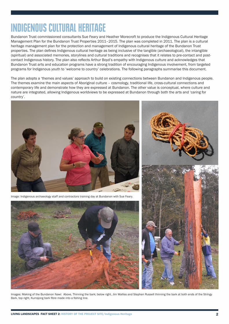
INDIGENOUS CULTURAL HERITAGEBundanon Trust commissioned consultants Sue Feary and Heather Morecroft to produce the Indigenous Cultural Heritage Management Plan for the Bundanon Trust Properties 2011–2015. The plan was completed in 2011. The plan is a cultural heritage management plan for the protection and management of Indigenous cultural heritage of the Bundanon Trust properties. The plan defines Indigenous cultural heritage as being inclusive of the tangible (archaeological), the intangible (spiritual) and associated memories, storylines and cultural traditions and recognises that it relates to pre-contact and post-contact Indigenous history. The plan also reflects Arthur Boyd’s empathy with Indigenous culture and acknowledges that Bundanon Trust arts and education programs have a strong tradition of encouraging Indigenous involvement, from targeted programs for Indigenous youth to ‘welcome to country’ celebrations. The following paragraphs summarise this document.
The plan adopts a ‘themes and values’ approach to build on existing connections between Bundanon and Indigenous people. The themes examine the main aspects of Aboriginal culture – cosmology, traditional life, cross-cultural connections and contemporary life and demonstrate how they are expressed at Bundanon. The other value is conceptual, where culture and nature are integrated, allowing Indigenous worldviews to be expressed at Bundanon through both the arts and ‘caring for country’.
Image: Indigenous archaeology staff and contractors training day at Bundanon with Sue Feary.
Images: Making of the Bundanon Nawi: Above, Thinning the bark; below right, Jim Walliss and Stephen Russell thinning the bark at both ends of the Stringy Bark, top right, Kurrajong bark fibre made into a fishing line.

3LIVING LANDSCAPES FACT SHEET 2: HISTORY OF THE PROJECT SITE/ Indigenous Heritage
FINDINGS OF THE INDIGENOUS CULTURAL HERITAGE MANAGEMENT PLANIn archaeological investigations for the plan across all the properties, very few sites were found suggesting that this part of the Shoalhaven catchment did not support a large Indigenous population in traditional times. The location of the properties at the tidal limit of the river, as well as near a major topographic boundary, are put forward as a possible explanation, as Indigenous groups were often divided along coastal and inland lines.
Review of the ethnographic and ethnohistoric literature demonstrates a substantial Indigenous presence in the area at white contact. Thus literature includes settler’s diaries and ethnographic research. The Shoalhaven River has one of the largest deltaic-estuarine ecosystems in South-Eastern NSW supporting wide range of edible birds, fish and mammal species, as well as plants for food, fibre and medicine. The natural flooding regimes of the river would have necessitated seasonal occupation.
There are no formal records of Aboriginal sites on any of the properties; although several are recorded nearby. A limited amount of archaeological investigation involving four days of fieldwork on land and by water across the six major landforms was completed. Despite intensive scrutiny, very little archaeological evidence was found. Two sets of axe grinding grooves were found. The absence of sites is considered to be a true reflection of the archaeological footprint on the properties.
The Indigenous people who included the Bundanon Trust properties in their traditional country, were part of the larger Yuin group (sometimes referred to as the Yuin Nation by Aboriginal people today), possibly within a smaller group called Gurungatta-manji, with close ties and associations with the Wodi Wodi people to the north. They spoke a dialect of the Dharawal language or possibly Mudthung (Thurumba). They lived in small mobile clan groups, such as the ‘Burrier Blacks’, managing their own tract of country according to traditional law and customs.
Diaries of local settlers contain references to Aboriginal people. The Biddulph brothers lived at Eearie Park from around 1855 and their diaries contain references to Aboriginal people living and working on their properties. In 1876 a breastplate was found by the Biddulph family at the ‘blacks camping ground, Sandy Point’ Groups of local Aboriginals were involved in picking peas, corn and other vegetables on nearby properties on the River, such as Wogamia, the Emery’s property. The three Aboriginal reserves of most relevance to the Shoalhaven were Roseby Park at Orient Point near the mouth of the Shoalhaven River, Wreck Bay Reserve at the southern end of Jervis Bay and Wallaga Lake Reserve near Bermagui on the far South Coast.
The Bundanon Trust properties fall within the boundaries of the Nowra Local Aboriginal Land Council (NLALC), based in Bomaderry on the site of the Bomaderry Aboriginal Children’s Home.
Image: Students from Bomaderry High School listen to Auntie Julie Freeman, Elder of the Wreck Bay Community about Indigenous cultural life.
LINK to Indigenous Cultural Heritage Management Plan for the Bundanon Trust Properties 2011–2015 here
Values: The space and place of the Bundanon Trust properties In fulfilling the vision of Arthur Boyd and his family, Bundanon Trust has created a space that emphasises the integration and connectedness of nature, culture and art in the landscape. This space also reflects the Indigenous perspective of country, with everything being connected.
In managing the properties, it is the desire of the Trust to recognise and respect the traditional custodians of the Bundanon Trust properties and to protect and conserve the Indigenous cultural heritage of the area.
The Trust aims to be recognised for its respect and understanding of Indigenous cultural heritage and values and for its role in addressing Indigenous social and economic disadvantage. The protection and maintenance of the tangible and intangible Indigenous cultural heritage of the Trust properties is a priority. The Trust aims to run integrated programs that promote the connection between people, nature, culture, arts and the environment.
4LIVING LANDSCAPES FACT SHEET 2: HISTORY OF THE PROJECT SITE/ Brief History of the Bundanon Property
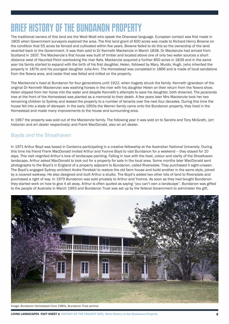
BRIEF HISTORY OF THE BUNDANON PROPERTYThe traditional owners of this land are the Wodi Wodi who speak the Dharawal language. European contact was first made in 1805 when Government surveyors explored the area. The first land grant of 600 acres was made to Richard Henry Browne on the condition that 55 acres be fenced and cultivated within five years. Browne failed to do this so the ownership of the land reverted back to the Government. It was then sold to Dr Kenneth Mackenzie in March 1838. Dr Mackenzie had arrived from Scotland in 1837. The Mackenzie’s first house was built of timber and located above one of only two water sources a short distance west of Haunted Point overlooking the river flats. Mackenzie acquired a further 850 acres in 1839 and in the same year his family started to expand with the birth of his first daughter, Helen, followed by Mary, Murdo, Hugh, (who inherited the property in 1879) and his youngest daughter Julia-Ann. The Homestead was completed in 1866 and is made of local sandstone from the Nowra area, and cedar that was felled and milled on the property.
The Mackenzie’s lived at Bundanon for four generations until 1922, when tragedy struck the family. Kenneth (grandson of the original Dr Kenneth Mackenzie) was washing horses in the river with his daughter Helen on their return from the Nowra show. Helen slipped from her horse into the water and despite Kenneth’s attempts to save his daughter, both drowned. The jacaranda tree at the front of the Homestead was planted as a memorial to their death. A few years later Mrs Mackenzie took her two remaining children to Sydney and leased the property to a number of tenants over the next four decades. During this time the house fell into a state of disrepair. In the early 1950s the Warren family came onto the Bundanon property, they lived in the Homestead and made many improvements to the house and surrounding area.
In 1967 the property was sold out of the Mackenzie family. The following year it was sold on to Sandra and Tony McGrath, (art historian and art dealer respectively) and Frank MacDonald, also an art dealer.
Boyds and the Shoalhaven
In 1971 Arthur Boyd was based in Canberra participating in a creative fellowship at the Australian National University. During this time his friend Frank MacDonald invited Arthur and Yvonne Boyd to visit Bundanon for a weekend – they stayed for 10 days. This visit reignited Arthur’s love of landscape painting. Falling in love with the heat, colour and clarity of the Shoalhaven landscape, Arthur asked MacDonald to look out for a property for sale in the local area. Some months later MacDonald sent photographs to the Boyd’s in England of a property adjacent to Bundanon, called Riversdale. They purchased it sight-unseen. The Boyd’s engaged Sydney architect Andre Porebski to restore the old farm house and build another in the same style, joined by a covered walkway. He also designed and built Arthur a studio. The Boyd’s added two other lots of land to Riversdale and purchased a right of way. In 1979 Bundanon was sold privately to Arthur and Yvonne. As soon as they had bought Bundanon they started work on how to give it all away. Arthur is often quoted as saying “you can’t own a landscape”. Bundanon was gifted to the people of Australia in March 1993 and Bundanon Trust was set up by the federal Government to administer the gift.
Image: Bundanon Homestead Circa 1980s, Bundanon Trust archive

5
DETAILED HISTORY OF THE BUNDANON TRUST PROPERTIESExploration and Early Settlement 1805-1838
The site of Bundanon was first seen by Europeans in 1805 when James Meehan, a Government surveyor, sailed from Port Jackson to the mouth of the Crookhaven River and inspected the Shoalhaven River as far west as the Burrier ford. Although isolated timber getters had explored the hinterland of the Shoalhaven Valley in the early 1800s, the route through the Shoalhaven gorge country was not mapped until Meehan’s surveys. In 1819 the Government surveyors John Oxley and James Meehan had explored Jervis Bay, Currambene Creek and the future site of the Nowra settlement with the intention of finding an overland route from the Southern Highlands to Jervis Bay. The track from Burrier to the coast was confirmed as a land route. This early exploration enabled Alexander Berry and Edward Wollstonecraft to become established on their land grant at Coolangatta by 1822, quickly followed by other colonists in search of land.
The Bundanon property was first leased by Richard Henry Browne in 1832, at a rent of £4/10/- per annum. The conditions of these grants were that within five years 55 acres must be cleared. Browne failed to clear the required amount of land to retain the lease.
Bundanon 1838-1860
Bundanon was sold to Dr Kenneth Mackenzie on 19th March 1838 for the sum of £400. Bundanon became the Mackenzie family home with the first timber homestead located above one of only two water sources, overlooking the river flats.
The disastrous Shoalhaven River flood of 1860, which inundated the region, impacted dramatically on the landscapes surrounding Bundanon. The river rose 120 feet at Burrier before dropping to 75 feet at Eearie Park. All the surrounding properties suffered the loss of stock, cattle and pigs, and wheat stored in barns and stacks. Arable land was covered with several feet of sand and other material deposited by the river. The farm, stock and land at Bundanon would also have suffered significant damage.
Bundanon 1861-1879
The two-storey stone homestead at Bundanon was completed in 1866, prompted by the need for increased room for the growing Mackenzie family, which in 1860 ranged from 12 to 21 years of age. The homestead at Bundanon was built of local sandstone and timber, with lime mortar made from shell deposits collected downstream and transported by river boat. The house was sited on high ground above the flood level of the river, which took advantage of cooling breezes and provided views across the property. Doors, windows and all internal fine joinery were of locally cut cedar with the exception of the floors which were hardwood. Ceilings were lined with wide planks of red cedar. The Mackenzie family lived in their new house at Bundanon after 1866. Workers on the property were employed both on the farm and as domestic servants in the new house.
In 1870 a serious flood had even greater impact on the properties along the Shoalhaven River than the earlier flood of 1860. A letter written by Hugh Mackenzie to one of his sisters following the floods is an important window into the landscape at Bundanon in 1870. In Hugh’s words the ‘... mother of all floods’ ruined Bundanon. Fences, yards and buildings were washed away and other buildings severely damaged. The strategically sited homestead with its skillion kitchen appears to have been the only structure above the flood level. The letter clearly documents the site and those people living in or near the main house on the night of the flood. Property structures described by Hugh in his letter included a punt, stockyards with gates, a barn, a dairy, a mangle room, a slab stable with loft, an old workshop, Murphy’s hut, a forge, and pig and fowl pens. Geese, turkeys and bees were stocked. Significantly the workers ‘huts’ remained above the flood level, as did the kitchen and main house. There is no mention of servants’ quarters or of any other farm buildings in the letter. However we can safely assume the existence of cow bails given the presence of a dairy, and that the punt referred to was used to cross the river below Bamerang.
In his letter Hugh Mackenzie clearly implied that he would not farm the property again in view of the flood damage. The extent of the disaster was publicly recorded in The Shoalhaven News on 5th May 1870. ‘... The farm at Bundanon is one mass of clean washed sand, and from thence down both sides of the river by Riversdale and Mr Kennedy’s farm.’
In 1877 the Thomsons of Burrier were supplying beef to Bundanon and buying stock from Bundanon. The orchard at Bundanon also provided fruit for the Thomson family in the 1880s, while bullocks for ploughing were freely exchanged between the Thomson and Mackenzie families. The two Bunyah pines identifying the track to the punt, and other pines identifying two other entrances to Bundanon Common, appear to have been planted at this time. Following the death of Dr Kenneth Mackenzie on 12th March 1879, Hugh Mackenzie inherited the property.
LIVING LANDSCAPES FACT SHEET 2: HISTORY OF THE PROJECT SITE/ Detailed History of the Bundanon Property

6
Bundanon 1879-1916
Although Hugh MacKenzie had declared in his letter of 1870 that he would not continue farming at Bundanon, the property continued to employ a relatively stable workforce. A number of women worked both as domestics and probably on the farm milking. A photograph of the new servants’ quarters taken before construction of the hipped roof kitchen and brick water cistern suggests that four domestics, dressed for ‘service’, were employed by the 1890s.
Development of the Bundanon property under Hugh Mackenzie consolidated the land use patterns of the 1870s. By the early 1900s the homestead was the focus of an estate which reflected the self-contained nature of the rural community at Bundanon. The ridge of high ground which formed the axis of the farm and homestead complex serviced both domestic and farm activities. Service areas including a smithy, laundry and buggy shed were sited near the western gate to the homestead yard.
To the north a range of service buildings, including a curing shed for hams and bacon, were located in treed areas which gave way in the east to large fenced vegetable and orchard plots above the dam. An extensive system of post and rail and wire fences controlled stock movements and defined arable areas planted with maize and lucerne. Other buildings in the homestead yard included stables, stallion shed and maize store while below the homestead fence were a 32 cow feed stall and five bails.
Beyond the gate were stockyards, slab sheds, slab barn and pig pens. The need for quantities of clean water was evident in the number of galvanised iron rainwater tanks associated with the house and working buildings.
The introduction of cream separators in the 1890s increased pig farming in the district, since the skimmed milk separating produced was valuable as feed. Bundanon farmed pigs at this time since piglets were regularly purchased by the Mackenzies from the Thomsons at Burrier. The orchard provided locquats while new bee hives provided ample honey. A tennis court was well established at Bundanon by 1902 and extensively used by the extended family.
Images: Top, Moving beehives at Bundanon, Centre, Servants quarters at Bundanon, Bottom, early 1900s, showing farm layout, looking towards the back of the homestead
Detail of an early 1900s photo of fishing on the Shoalhaven River near Bundanon. Note the willows which no longer exist.
LIVING LANDSCAPES FACT SHEET 2: HISTORY OF THE PROJECT SITE/ Detailed History of the Bundanon Property

7
Bundanon 1917-1927
The onset of the First World War in 1914 saw a dramatic reduction in the number of farm labourers and domestic servants. The working of the property at this time continued the patterns established by the 1880s. Under Kenneth Mackenzie, Bundanon was home to between twenty-five and thirty people, including the Mackenzie family and five to six farm labourers’ and servants’ families. The latter were accommodated in houses and huts on the property including the old homestead. Three timber workers’ cottages, including the manager’s house, were located north of the main house with smaller ‘humpies’ or ‘huts’ in the vicinity of the slab barn near the western boundary of the property.
A singleman’s hut or cottage across the lagoon provided permanent accommodation for one person, with a second identical room for overnight visiting workers. Each room held an iron bed and mattress, table, billy can and pannikin, cutlery, tea and sugar and tin of biscuits; a built-in timber cupboard at the side of each fireplace provided storage. A fourth timber worker’s cottage was erected around 1920 adjacent to the western-most slab barn. Elinor Dillon described the working of the main house in the early years of this century. Downstairs was the ‘large’ room, a bedroom and a gun room; upstairs were four bedrooms. Food was carried in on trays to the dining room from the kitchen. According to Elinor, the singleman’s hut was originally built for an Aboriginal man who worked on the property .
Due to the nature of the river flats, grazing was only moderate to poor in quality but the soil could produce good corn and lucerne crops. In good years some 500 to 600 bags of corn were held in the large barns west of the stock yards. Teams of ten bullocks pulled the dray with up to ten bags of corn harvested from the lower paddocks near the river. In winter lucerne crops supplemented the feed available to cattle and horses. Three single furrow ploughs were used to prepare the ground for planting, each pulled by two horses on the river flats.
The introduction of super phosphate in 1925 increased production and yields. The dairy herd of Jersey and Illawarra cross cattle was normally milked by three people. Milking took place daily, beginning at 3 am and then again at 3 pm. Milk was taken to the factory at Bomaderry every day at 7.30 am using the punt. The mail, bread and meat for the property were collected in town. When it was not possible to cross the river, milk was separated into cream and skimmed milk. The latter was fed to the twenty to thirty pigs held on the flats below the bails. There was a punt/cable and a tin shed on the Bamarang side with a sulky or buggy. A bell was rung to attract attention.
Later the punt was replaced with a larger version capable of carrying a horse and buggy, and a small boat was left on the opposite side to the punt. Horses were kept for stock work, show and ploughing. Show horses were taken to the Nowra Showground. Draught horses, bred on the property, were kept in the stables. The yard was used to hold stallions and mares which were taken to Yalwal Station for few months each year. Cattle were brought from as far as Braidwood to Yalwal Station for fattening as ‘store cattle’.
Image punt at the river
Image: Farmer ploughing at Eearie park
The deaths of Kenneth Mackenzie and his daughter Helen, who were drowned on 29 January 1922, appear to have resulted in a decline in family involvement with farming at Bundanon. Helen had been to the Nowra Show with her sister Jean, and was washing her pony in the river when she was swept away. Kenneth went to her help, but both were drowned.The jacaranda tree in front of the house was planted in their memory. The Mackenzie family left Bundanon in 1926.
LIVING LANDSCAPES FACT SHEET 2: HISTORY OF THE PROJECT SITE/ Detailed History of the Bundanon Property

8
Bundanon 1927-1934
Bundanon was leased in 1927 to George & Florence Henry and family. Mrs Edna Condie, nee Henry, documented the buildings in use. These included a carpenters and blacksmiths sheds, laundry, workshop, stables, buggy shed and a dairy and bails. In the late 1920s the property appears to have changed slowly. Changes were limited to removal of one of the early slab sheds at the stockyards and the addition of new sheds on the ‘common’.
Davis and Martin Occupation 1934-1946
Bundanon was occupied in turn by two families during this period; those of Tom Davis Snr, a local, and John Martin. Tom Davis Snr leased the property 1934-35 and 1945-46. John Martin and his son Fred Martin ran the property between 1935 and 1945. The dam below the main house was lowered around 1945.
Scott Family Occupation 1946-1957
The Scott family purchased the stock and plant from their predecessors on the property paying some £400 rent per annum to the MacKenzie family. With the assistance of sons Don, Bill and Robert, Alf Scott introduced extensive cropping for feed for cattle, growing lucerne and feeding huge amounts cut daily for up to 100 milking cows. The Jersey/Friesian cross cattle produced milk richer in butterfat but lower in volume at approximately 200 gallons per day. New cropping areas were developed to the north and west of the homestead with the need to increase production. The river flats were intensively cultivated for corn with over 200 three-bushel bags produced for Kellogg’s at £1 per bushel.
Although there was some modification and loss of ancillary working structures recorded in photographs of the 1920s and earlier the property still retained its two remaining worker’s cottages, six staff rooms, a well-equipped schoolroom and the singleman’s quarters in addition to most early homestead structures. Between 1946 and 1949 Worker’s Cottage 1 was extended to the north by the addition of a gabled kitchen. A new barn was built later to replace the two slab sheds west of the western entrance to Bundanon Common. North of the stockyards new enclosures with small shelters were used as pig pens. The pigs were fed with whey from the dairy as was the custom elsewhere in Shoalhaven.
In the 1950s the Scotts bought stock and plant at Eearie Park, setting up eldest son Don on the property. Don did not stay on the property and moved to Nowra. Bill Scott married in 1956 and moved to Wilcannia. In 1958 the Scott family sold stock and plant to Neil Boomer from Kangaroo Valley.
Boomer and Warren Occupation 1957-1969
In 1957 Neil Boomer from Kangaroo Valley leased the property but was soon replaced by the Warren family. The Warren family, Harry and Lorna and their two teenage sons, leased and ran the Bundanon property from 1958 to 1968. While living at Bundanon the Warren family carried out many repairs on the Homestead, workers and managers cottages which had all fallen into poor condition. They also re-established and maintained the kitchen garden, continued to run the diary, sending milk twice a day by river to Nowra, grew crops, ran pigs and chickens. In this time the two teenage sons grew up, got married and had their own children all living at Bundanon. In 1967 Bundanon was sold to Jim Lawrence by Colin Mackenzie The Warren family stayed on after sale until 1969. In 1968 Bundanon was sold to Sandra and Michael Anthony McGrath and Francis MacDonald, art dealers, for $56,000.
Richard Stone and Gwen Stone (Harper) at Bundanon, c1960s, Bundanon Trust archive
This photo clearly shows crops of maize and peas growing on the river flats at Bundanon.
LIVING LANDSCAPES FACT SHEET 2: HISTORY OF THE PROJECT SITE/ Detailed History of the Bundanon Property

9
McGrath and McDonald Occupation 1968-1978/79
Farming operations at Bundanon continued under the new owners. A 1970s article in The Australian Home Journal by Carol Henty entitled ‘The Happy Valley’ described how ‘... a Sydney art dealer had built a mid-nineteenth century landscape on a grand scale’. The architectural practice of Allan, Jack & Cottier had been commissioned in 1968 to undertake the necessary work. In the process of doing so all the nineteenth and early twentieth century working buildings on ‘Bundanon Common’ were removed, in addition to the former Bundanon schoolhouse and skillion kitchen to the main house. Before 1968 the landscape setting of the main house was articulated by the river crossing, defined by two Bunyah pines, and the working axis defined by Bundanon Common and the little used road from Beeweeree and Cambewarra to the west.
Under MacDonald and the McGraths the landscape setting changed dramatically. Changes included tree planting, a modified ‘cottage’ garden setting for the house, servants’ quarters and kitchen and extensive plantings of American poplars along an adopted track below the feedstalls and dairy to the punt. Lombardy poplars were planted in the wider landscape as indicators of scale and ownership. In keeping with the 19th century ‘vision’ the landscape was modified; the stark contrast between the uncleared bush and the paddocks surrounding the house was reduced by selective thinning. With the removal of the majority of working farm buildings there was an urgent need to build modern farm facilities. A new barn and workshops were erected close to Worker’s Cottage 1, integrated with the late nineteenth century slab barn. The homestead was renovated during the 1960s.
Images: Images of Bundanon during the MacDonald and the McGrath era
LIVING LANDSCAPES FACT SHEET 2: HISTORY OF THE PROJECT SITE/ Detailed History of the Bundanon Property
10
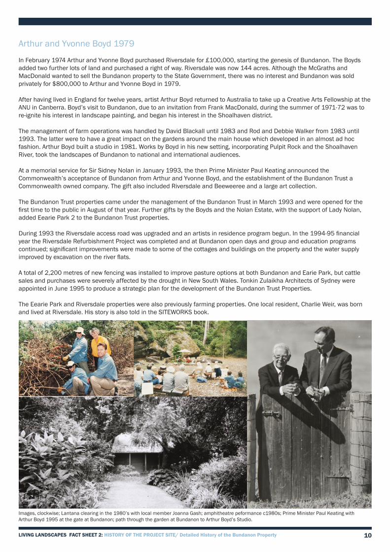
Arthur and Yvonne Boyd 1979
In February 1974 Arthur and Yvonne Boyd purchased Riversdale for £100,000, starting the genesis of Bundanon. The Boyds added two further lots of land and purchased a right of way. Riversdale was now 144 acres. Although the McGraths and MacDonald wanted to sell the Bundanon property to the State Government, there was no interest and Bundanon was sold privately for $800,000 to Arthur and Yvonne Boyd in 1979.
After having lived in England for twelve years, artist Arthur Boyd returned to Australia to take up a Creative Arts Fellowship at the ANU in Canberra. Boyd’s visit to Bundanon, due to an invitation from Frank MacDonald, during the summer of 1971-72 was to re-ignite his interest in landscape painting, and began his interest in the Shoalhaven district.
The management of farm operations was handled by David Blackall until 1983 and Rod and Debbie Walker from 1983 until 1993. The latter were to have a great impact on the gardens around the main house which developed in an almost ad hoc fashion. Arthur Boyd built a studio in 1981. Works by Boyd in his new setting, incorporating Pulpit Rock and the Shoalhaven River, took the landscapes of Bundanon to national and international audiences.
At a memorial service for Sir Sidney Nolan in January 1993, the then Prime Minister Paul Keating announced the Commonwealth’s acceptance of Bundanon from Arthur and Yvonne Boyd, and the establishment of the Bundanon Trust a Commonwealth owned company. The gift also included Riversdale and Beeweeree and a large art collection.
The Bundanon Trust properties came under the management of the Bundanon Trust in March 1993 and were opened for the first time to the public in August of that year. Further gifts by the Boyds and the Nolan Estate, with the support of Lady Nolan, added Eearie Park 2 to the Bundanon Trust properties.
During 1993 the Riversdale access road was upgraded and an artists in residence program begun. In the 1994-95 financial year the Riversdale Refurbishment Project was completed and at Bundanon open days and group and education programs continued; significant improvements were made to some of the cottages and buildings on the property and the water supply improved by excavation on the river flats.
A total of 2,200 metres of new fencing was installed to improve pasture options at both Bundanon and Earie Park, but cattle sales and purchases were severely affected by the drought in New South Wales. Tonkin Zulaikha Architects of Sydney were appointed in June 1995 to produce a strategic plan for the development of the Bundanon Trust Properties.
The Eearie Park and Riversdale properties were also previously farming properties. One local resident, Charlie Weir, was born and lived at Riversdale. His story is also told in the SITEWORKS book.
Images, clockwise; Lantana clearing in the 1980’s with local member Joanna Gash; amphitheatre peformance c1980s; Prime Minister Paul Keating with Arthur Boyd 1995 at the gate at Bundanon; path through the garden at Bundanon to Arthur Boyd’s Studio.
LIVING LANDSCAPES FACT SHEET 2: HISTORY OF THE PROJECT SITE/ Detailed History of the Bundanon Property

11
Summary of land use
Settlement for pastoral activity made it mandatory to understand the environment in order to be self-sufficient and to make a living from the land. The 600 acres of the original land grant consisted of 300 acres of usable river flats and terraces backed by a line of steep hills defining the line of the river and the northern edge of the grant. Clearly the pattern of flooding which must have been quite obvious to settlers after 1842 and 1852, and which was to repeat itself at roughly ten year intervals, was a controlling factor but not the only one. The three river terraces, formed in part as levee banks, would have provided relatively flat terrain for arable production once cleared.
Although no roads were shown on the 1859 Old Roll Map linking Bundanon with Eearie Park we can assume that a track existed at an early date as a result of the frequent flooding. Both a punt and boat were mentioned in Hugh Mackenzie’s letter of 1870 indicating that the river crossing was in use well before 1870. Given the frequency of flooding there was little choice as to where houses and farm buildings could be located. Although no pre 1866 buildings (the main house) have survived we can safely assume that the land use patterns of 1866 which were in full production at the turn of the century were already well developed.
The landscape developed into clearly structured spaces by 1900 articulated by the ridge of high ground occupied by the main house and its supporting buildings. The main house characteristically dominated the river flats and from the south-east towards the site of the former punt. To the east and south of the house the landscape was a mosaic of ten to twelve-acre paddocks with boundary alignments defined by the river terraces. A single large field along the Shoalhaven River to the south occupied the lowest river terrace. A well-defined track linked the house and farm buildings. A continuation of this track to the east linked with employee’s huts and farm buildings established at the junction of the cleared land and the hills near Haunted Point. Two, or possibly three dams [presumably built around one or more existing lagoons], established on seasonal water courses, provided an additional resource. The shallow valley between the main house and higher ground provided a sheltered microclimate for vegetable gardens, orchard and fowl house and poultry.
Image: View from Pulpit Rock of Bundanon property and the Shoalhaven River circa 1940s
View Property Manager Henry Goodall discussing the history of the property and farming cattle in the opening sequence of ‘RT160 - The Beast of Bundanon.’ This was produced for the Siteworks 2012 event Saturday 29th September. http://vimeo.com/50143722
LIVING LANDSCAPES FACT SHEET 2: HISTORY OF THE PROJECT SITE/Summary of land use