history & geography - mes.intnet.mumes.intnet.mu/english/documents/examinations... · it also...
TRANSCRIPT
2017February
GRADE 5
Mauritius Examinations Syndicate
PRIMARY SCHOOLACHIEVEMENT CERTIFICATE
This document contains the History & Geography assessment booklet for candidates who will take the Grade 5 PSAC assessment in 2017. It also contains the explanatory notes which include useful information on the modular assessment for this subject as well as the specimen mark scheme. The Assessment Objectives and learning objectives/learningoutcomes for each question have been inserted in boxes for ease of reference.
Specimen Assessment Booklet
HISTORY & GEOGRAPHY

ii | PSAC

PSAC | i
1. Introduction
The Primary SchoolAchievement Certificate (PSAC)Assessment has beendesigned in line with the goals and objectives of the National Curriculum Framework(NCF)forPrimaryEducation.ThedesignandformatoftheHistory& Geography assessment booklet aim at aligning the assessment objectives in the assessment syllabus with the aims and objectives of the NCF for
Grades 1-6 and the learning outcomes in the Teaching and Learning Syllabus. They also seek to enhance the pedagogical experience pupils would derive from the assessment.
The modular assessment in History & Geography at Grade 5 is being introduced in the year 2017 and will contribute to 50% of the PSAC Assessment for this subject.
2. Purpose of the Assessment
The purpose of the PSAC Assessment in History & Geography is to measure and certify pupils’ levels of achievement in History and Geography at the end of the primary education cycle.
The assessment has been revised to lay a stronger emphasis on pupils’ conceptual understanding and application of knowledge and skills, while still requiring that pupils have solid subject knowledge base.
The aims of the assessment in History & Geography are aligned with those of the National Curriculum Framework Grades 1 to 6, October 2015 and the Teaching and Learning History and Geography syllabus Grades 1 to 6, October 2015, which are to develop:
• Pupils’ knowledge and understanding of the subject; • Pupils’ acquisition of inquiry skills, critical thinking and communication skills; • Positive attitudes and values such as respect for different cultures and
heritage; • Pupils’ sense of belonging to the nation.
3. Modular Assessment
The modular assessment in History & Geography is being introduced as part of the new end of primary cycle assessment, the Primary School Achievement Certificate (PSAC). The modular assessment will be taken in two parts: thefirst part of the assessmentwill be at the end ofGrade 5 and the second partwill be towards the end of Grade 6. The Grade 5 modular assessment will be introduced in 2017 and will be based on the Grade 5 syllabus. The pupils will take

ii | PSAC
the second modular assessment when they will complete the Grade 6 learning programme in 2018. The Grade 6 modular assessment will be based mainly on the
Grade 6 syllabus.
4. Guiding Principles
The Standard V end of year assessment was conducted to provide feedback to Educators. It assessed mainly the recall of facts and concepts. The assessment in
StandardVdidnotcontributetotheendofprimarycyclecertificationprocess.
With the introduction of the modular assessment in History & Geography as part of the PSAC assessment, the assessment has been reviewed. The new Grade 5 Specimen Assessment Booklet has been designed and developed guided by principles of fairness, the need to set learning standards, the importance of ensuring positive washback, the educational value of the
inquiry-based approach and the contribution of the subject to the overall education of pupils.
The types of questions range from objective-type questions such as MCQ/Fill-in-the-blanks to open-ended Short Answer/Structured questions. The questions will assess knowledge, understanding, application and skills in a graded manner. The question paper will comprise 7-8 questions and will be of a duration of 1 hour.
The new approach in the curriculum will encourage Educators to put emphasis on key concepts and core skills and to develop a deeper understanding of the subject.
Thisjustifiesthenewweightingsof40%totheAssessmentObjective‘Understanding’and30%totheAssessmentObjective‘Application’.
The weighting and individual marks allocated to objective-type questions such as multiple choice questions have been reviewed to reduce the importance and influence of this question format on the overall assessment. In the Standard Vend of year assessment paper, the items in the MCQs and other objective type questions such as fill-in-the-blanks andmatching types carried twomarks eachand accounted for at least 60-70% of the total marks. For pupils in the lowest ability range, such a practice did not encourage the development of writing skills even in very short answer questions. For higher ability pupils, such a practice tended to affect their overall performance in the subject.
5. Paper Description
The Specimen Assessment Booklet illustrates the design and format of the PSAC Grade 5 assessment and the types of questions that might be set and the level at which the different content and skills may be assessed. It has been set in
accordancewithablueprint(tableofspecifications)whichrespectstheweightings of the assessment objectives given in the Annual Programme for the PSAC
Assessment. It contains 8 questions, for a total of 50 marks and is of a duration of
PSAC | iii
1 hour. There will be a variety of types of questions.
The following needs to be highlighted:
• The questions and items/part questions will be graded and will be based on the firstthreelevelsofBloom’staxonomy.
• Map skills will not be assessed as a separate question. They have been integrated in the Geography and History topics in the curriculum. They will be assessed in a topical way as shown in the specimen assessment booklet.
• Multiple-choice questions such as Questions 2 and 3 assessing Geography and History will not carry more than 8 marks each.
• An open ended/structured short answer question such as Question 7/8 will not carry more than 10 marks.
• The assessment will aim to encourage the development of understanding, the skills of inquiry and application skills.
• The Specimen Mark Scheme gives indications about examiners’ expectations and standards to be reached.
• The boxes found alongside each question/part question in the specimen assessmentbookletindicatetheAssessmentObjectives(AO),theunits/topicsand the learning objectives/learning outcomes which are found in the Teaching and Learning Syllabus and the curriculum textbooks.
• TheformatofthePSACGrade5assessmentbookletisnotfixed.Thetypesandlevelsofquestionswillvary.Thiswillgivemoreflexibility in thepapersettingprocess. This will also make the assessment less predictable and rigid to avoid rote learning and an excessive focus on past paper practice.
6. Assessment Objectives
Learners should be able to:
Knowledge and Understanding• demonstrate relevant factual knowledge and understanding of concepts.
Application of Knowledge • construct explanations with relevant and reliable information; • select and apply knowledge; • makeinferencesand/orfindinformationtosupportideas;and• observe patterns and relationships in both content and ideas.

iv | PSAC
Subject Specific Skills • use and apply map skills; draw and label a diagram;• read, extract and interpret information from materials presented in the form of
historical sources, maps, tables, charts/graphs, diagrams, pictures and photographs.
Note: Environmental Education and subject skills such as map skills which are integrated wherever appropriate in the curriculum units and relevant topics will be assessed in the context of the questions set on given topics/themes.
The paper description for the History & Geography assessment in Grade 5 is given in the Annual Programme for the PSAC Assessment 2018. The following is an
extract from the document:
The assessment will have a modular approach. The first assessment will be carried out at the end of Grade 5 based on the Grade 5 syllabus and the second assessment will be set towards the end of Grade 6 and will be essentially based on the Grade 6 syllabus in History & Geography. Each paper will be of a duration of 1 hour and will each carry a total of 50 marks. Each assessment paper will carry a weighting of 50%.
The papers will comprise 7- 8 questions each with a number of items graded in terms of difficulty level.
The papers will comprise Multiple Choice items, fill-in-the-blanks, word association/matching type, diagram labelling, and open ended/structured short answer questions. The questions will also assess subject specific skills. The following table shows the weighting of the assessment objectives in History & Geography:
Weighting of the Assessment Objectives in the History & Geography Assessment Booklet
Assessment Objectives Weighting / %
Knowledge 30
Understanding 40
Application 30

PSAC | 1
HIS
TOR
Y &
GE
OG
RA
PH
Y(SubjectCodeNoP142/1)
mauritiusexaminationssyndicatemauritiusexaminationssyndicatemauritiusexaminationssyndicatemauritiusexaminationssyndicatemauritiusexaminationssyndicatemauritiusmauritiusexaminationssyndicatemauritiusexaminationssyndicatemauritiusexaminationssyndicatemauritiusexaminationssyndicatemauritiusexaminationssyndicatemauritiusmauritiusexaminationssyndicatemauritiusexaminationssyndicatemauritiusexaminationssyndicatemauritiusexaminationssyndicatemauritiusexaminationssyndicatemauritiusmauritiusexaminationssyndicatemauritiusexaminationssyndicatemauritiusexaminationssyndicatemauritiusexaminationssyndicatemauritiusexaminationssyndicatemauritiusmauritiusexaminationssyndicatemauritiusexaminationssyndicatemauritiusexaminationssyndicatemauritiusexaminationssyndicatemauritiusexaminationssyndicatemauritiusmauritiusexaminationssyndicatemauritiusexaminationssyndicatemauritiusexaminationssyndicatemauritiusexaminationssyndicatemauritiusexaminationssyndicatemauritiusmauritiusexaminationssyndicatemauritiusexaminationssyndicatemauritiusexaminationssyndicatemauritiusexaminationssyndicatemauritiusexaminationssyndicatemauritiusmauritiusexaminationssyndicatemauritiusexaminationssyndicatemauritiusexaminationssyndicatemauritiusexaminationssyndicatemauritiusexaminationssyndicatemauritiusmauritiusexaminationssyndicatemauritiusexaminationssyndicatemauritiusexaminationssyndicatemauritiusexaminationssyndicatemauritiusexaminationssyndicatemauritiusmauritiusexaminationssyndicatemauritiusexaminationssyndicatemauritiusexaminationssyndicatemauritiusexaminationssyndicatemauritiusexaminationssyndicatemauritiusmauritiusexaminationssyndicatemauritiusexaminationssyndicatemauritiusexaminationssyndicatemauritiusexaminationssyndicatemauritiusexaminationssyndicatemauritiusmauritiusexaminationssyndicatemauritiusexaminationssyndicatemauritiusexaminationssyndicatemauritiusexaminationssyndicatemauritiusexaminationssyndicatemauritiusmauritiusexaminationssyndicatemauritiusexaminationssyndicatemauritiusexaminationssyndicatemauritiusexaminationssyndicatemauritiusexaminationssyndicatemauritiusmauritiusexaminationssyndicatemauritiusexaminationssyndicatemauritiusexaminationssyndicatemauritiusexaminationssyndicatemauritiusexaminationssyndicatemauritiusmauritiusexaminationssyndicatemauritiusexaminationssyndicatemauritiusexaminationssyndicatemauritiusexaminationssyndicatemauritiusexaminationssyndicatemauritius
Index Number: .........................................................
MAURITIUS EXAMINATIONS SYNDICATE
Primary School Achievement Certificate AssessmentSpecimen Assessment Booklet for Grade 5 from 2017
Time: 1 hour Total marks: 50
INSTRUCTIONS TO CANDIDATES
1. Check that this assessment booklet contains 8 questions printed on 12 pagesnumbered2,3,4,5,6,7,8,9,10,11,12and13.
2. Write your Index Number on the assessment booklet in the space provided above.
3. You should not use red, green or black ink in answering questions.
4. Write all your answers clearly in the assessment booklet.
5. Attempt all questions.
QuestionMarking Revision Control
Marks Sig Marks Sig Marks Sig
1
2
3
4
5
6
7
8
TOTAL
Signature(HoG)

2 | PSAC
MarksQUESTION 1 (7 marks)
Study Map 1 carefully. It shows the height of the land in Mauritius. Then answer the
questions which follow.
Map 1
Quatre Bornes
Le Morne
Triolet
PortLouis
VerdunHill
CurepipePoint
XCENTRAL
PLATEAU
Y
400m
200m
contour line
dormant volcano
settlement
Key
200m
Scale
0 3 6 9 12 15km
AO:UseandApplyMapSkillsL.O:ReadandInterpretamapwithcontourlinesGrade5/Unit1/pp.44,50

PSAC | 3
MarksMarks (a) CompleteTable 1. Put a tick (✓) in the correct boxes to show the height of the land at the different places shown in Map 1. One example has been done for you.
Table 1
Place Below 200 m Between 200 m and 400 m Above 400 m
Port Louis ✓
Quatre Bornes
Curepipe Point
Le Morne
[3](b)CircleletterA, B, C or D to show the correct answer.
(i)WhatisthedirectionofLeMornevillagefromVerdunHill?
A North East B South East
C South West D North West [1]
(ii)ThewidthoftheCentralPlateaufromX to Y along the dotted line is about
A9km B 15 km C 21 km D 27 km [1]
(c)HowwastheCentralPlateauformed?
…………………………………………………………………………………………
………………………………………………………….………………..…………… [2]
L.O:Givethedirectionofoneplacefromanother pp.27,44,50
L.O:Makeuseofscaletomeasuredistancesonamap pp.26,44,50
AO: Construct explanationsL.O:Describeavolcanoineruption(p.29)/understandtheformationofrelieffeaturesofMauritius(pp.38,40)
4|PSAC
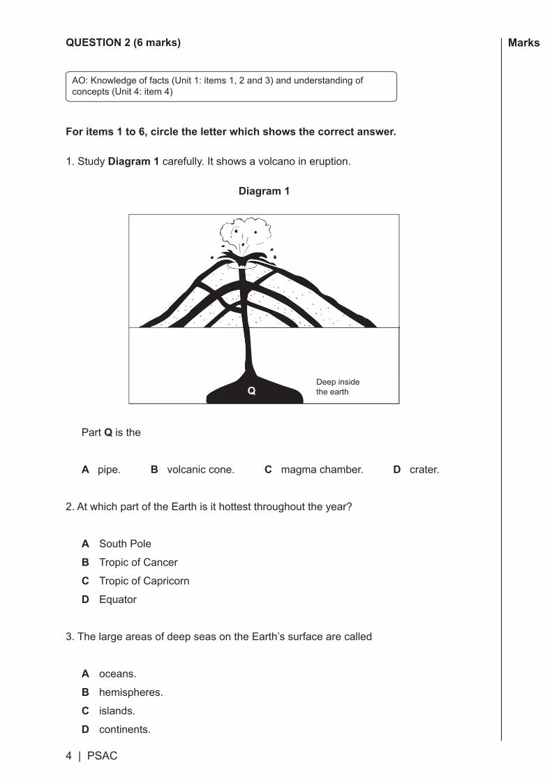
MarksQUESTION 2 (6 marks)
For items 1 to 6, circle the letter which shows the correct answer.
1. Study Diagram 1 carefully. It shows a volcano in eruption.
Diagram 1
Part Q is the
A pipe. B volcanic cone. C magma chamber. D crater.
2.AtwhichpartoftheEarthisithottestthroughouttheyear?
A South Pole
B Tropic of Cancer
C Tropic of Capricorn
D Equator
3. The large areas of deep seas on the Earth’s surface are called
A oceans.
B hemispheres.
C islands.
D continents.
Deep insidethe earthQ
AO:Knowledgeoffacts(Unit1:items1,2and3)andunderstandingofconcepts(Unit4:item4)
PSAC | 5
MarksMarks 4.Reliefrainoccurswhen
A it is cooler at night.
B the temperature of the sea is warm.
C air rises and condenses during the day in summer.
D air is forced to rise over highland areas.
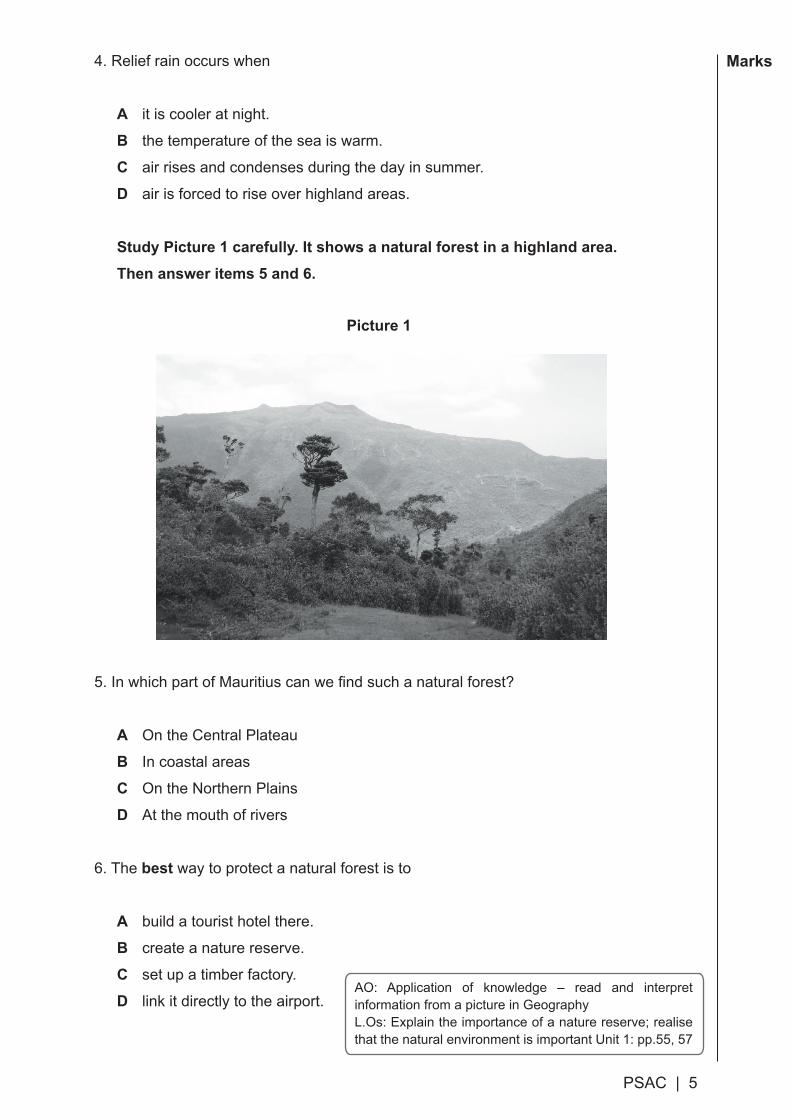
Study Picture 1 carefully. It shows a natural forest in a highland area.Then answer items 5 and 6.
Picture 1
5.InwhichpartofMauritiuscanwefindsuchanaturalforest?
A On the Central Plateau
B In coastal areas
C On the Northern Plains
D At the mouth of rivers
6. The best way to protect a natural forest is to
A build a tourist hotel there.
B create a nature reserve.
C set up a timber factory.
D link it directly to the airport.AO: Application of knowledge – read and interpret information from a picture in GeographyL.Os: Explain the importance of a nature reserve; realise thatthenaturalenvironmentisimportantUnit1:pp.55,57

6 | PSAC
MarksQUESTION 3 (7 marks)
For items 1 to 7, circle the letter which shows the correct answer.
Study Map 2 carefully. It shows the sea routes taken by the Portuguese and Dutch sailorsinthepastfromEuropetotheEastIndies.Thenansweritems1to4.
Map 2
1. Continent X is
A Europe. B Africa.
C Asia. D Australia.
2.ThePortuguesesailorwhofirstsailedroundtheCapeofGoodHopeand
reachedIndiain1498was
A Diogo Rodriguez. B Pedro Mascarenhas.
C Vasco da Gama. D Van Warwick.
Cape of Good Hope
MascareneIslands
Portugal
Holland
India
East Indies
AO: Knowledge of facts and understanding of concepts; read and interpret a map in History (items1,2,3,4)Unit2pp.68,70,83
Key sea route taken by the Portuguese
sea route taken by the Dutch
PSAC | 7
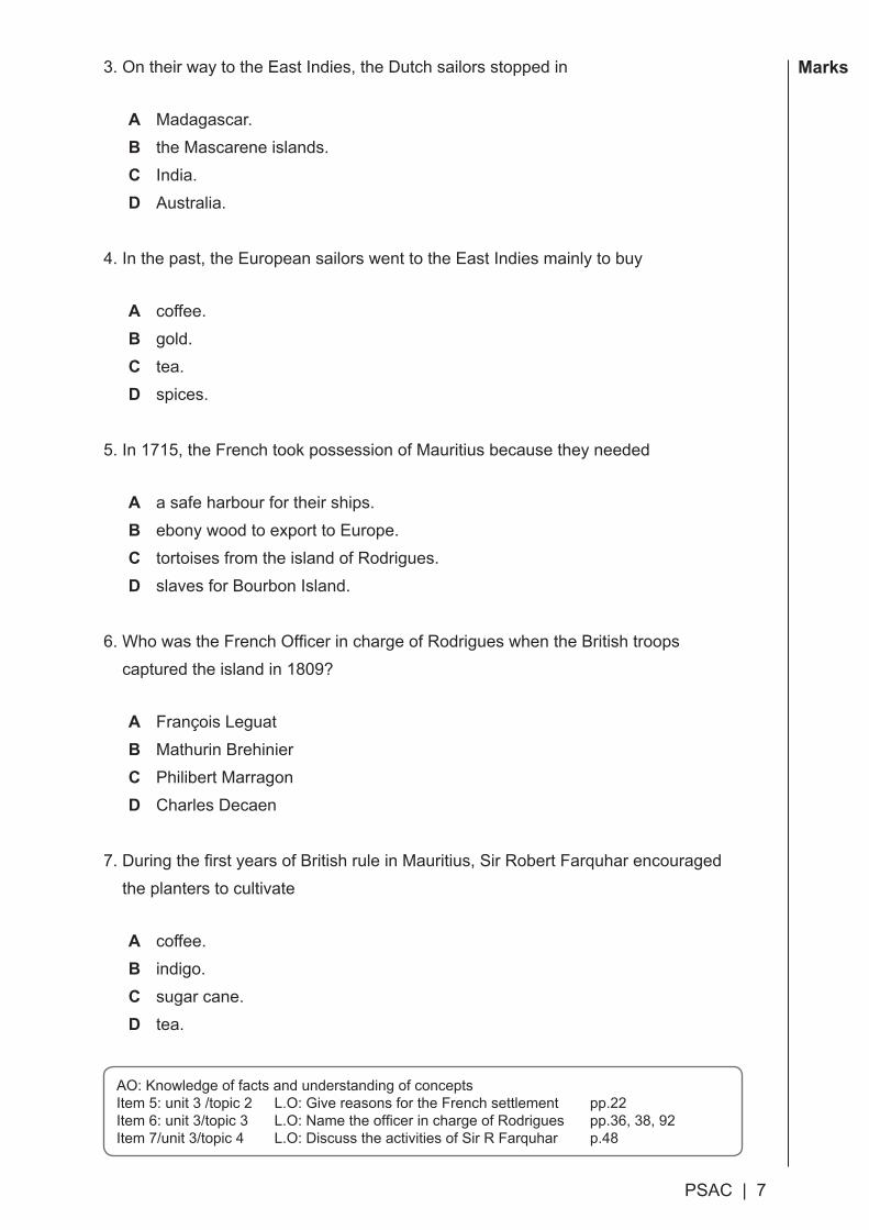
MarksMarks 3. On their way to the East Indies, the Dutch sailors stopped in
A Madagascar.B the Mascarene islands.C India. D Australia.
4.Inthepast,theEuropeansailorswenttotheEastIndiesmainlytobuy
A coffee. B gold.C tea. D spices.
5. In 1715, the French took possession of Mauritius because they needed
A a safe harbour for their ships.B ebony wood to export to Europe.C tortoises from the island of Rodrigues.D slaves for Bourbon Island.
6.WhowastheFrenchOfficerinchargeofRodrigueswhentheBritishtroopscapturedtheislandin1809?
A François LeguatB Mathurin BrehinierC Philibert MarragonD Charles Decaen
7.DuringthefirstyearsofBritishruleinMauritius,SirRobertFarquharencouraged the planters to cultivate
A coffee. B indigo.C sugar cane.D tea.
AO: Knowledge of facts and understanding of conceptsItem 5: unit 3 /topic 2 L.O: Give reasons for the French settlement pp.22Item6:unit3/topic3 L.O:NametheofficerinchargeofRodrigues pp.36,38,92Item7/unit3/topic4 L.O:DiscusstheactivitiesofSirRFarquhar p.48
8 | PSAC
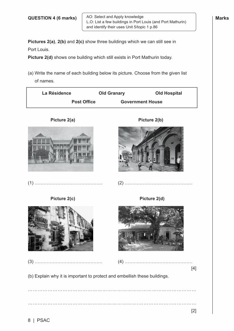
MarksQUESTION 4 (6 marks)
Pictures 2(a), 2(b) and 2(c) show three buildings which we can still see in
Port Louis.
Picture 2(d) shows one building which still exists in Port Mathurin today.
(a)Writethenameofeachbuildingbelowitspicture.Choosefromthegivenlist
of names.
La Résidence Old Granary Old Hospital
Post Office Government House
Picture 2(a) Picture 2(b)
(1)……………………………………… (2)………………………………………
Picture 2(c) Picture 2(d)
(3)……………………………………… (4)………………………………………[4]
(b)Explain why it is important to protect and embellish these buildings.
…………………………………………………………………………………………
………………………………………………………….………………..……………
[2]
AO: Select and Apply knowledgeL.O:ListafewbuildingsinPortLouis(andPortMathurin)andidentifytheirusesUnit5/topic1p.86

PSAC|9
MarksMarks QUESTION 5 (4 marks)
Fill in the blanks in sentences (a) to (e). Choose from the list of words below:
prevailing summer leeward
windward winter pollution isotherm
The first one has been done for you.
(a)Alineonamapjoiningplaceshavingthesametemperatureiscalledan
…………………………… .
(b)Convectionalrainoccursmainlyinthe………………………………season.
(c)TheSouthEastTradeWindsarecalled………......…………………winds.
(d)ThedistrictofBlackRiverisfoundonthe…………………..…………side
of Mauritius.
(e)Climatechangeiscausedmainlyby……..…………………………..of
the atmosphere.
[4]
isotherm
AO:Knowledgeoffactsandunderstandingofconcepts Unit4L.Os: Recall the instrument for measuring temperature - recap p.55Describe the formation of convectional rain and relief rain pp.65, 66Describewhatcausesclimatechange p.74

10 | PSAC
MarksQUESTION 6 (5 marks)
Fill in the blanks (a) to (e) in the short story about some of the achievements of French administrator Pierre Poivre in Ile de France.
Choose from this list of words:
ships slaves sugar cane spice rivers agriculture land
Pierre Poivre had travelled to China and to South East Asia. On his way to France
in 1753, he brought (a) ………………………………… plants to Ile de France.
When he became the administrator of Ile de France in 1767, Pierre Poivre
encouraged the French settlers to develop (b) …………..…...…………………….
He gave plots of (c) ……………………………… to other free people to develop the
town of Port Louis.
But without the hard work of the (d) ……..……………………………, Ile de France
would not have become a prosperous colony.
Pierre Poivre took important measures to protect the natural environment.
For example, he ordered the indigo factories to stop polluting the
(e) ……………..................…… and canals on the island.
[5]
AO:Applicationofknowledge-SelectandApplyknowledge Unit3/topic2.5pp.29,31L.O: State the contribution of Pierre Poivre in the development of agricultureGeneralObjective:Showaninterestinfindingoutaboutthepast

PSAC | 11
MarksMarks QUESTION 7 (9 marks)
1. Picture 3 shows the place in the area of Grand Port where Dutch sailors landed for the first time in Mauritius. Study it carefully. Then answer questions (a) and (b).
Picture 3
(a)WhatisthenameoftheplacewheretheDutchsailorslandedforthefirsttimein
1598?CircleletterA, B or C to show the correct answer.
A Vieux Grand Port B Ferney C Mahebourg [1]
(b)Describetwo activities of the Dutch sailors which are shown in Picture 3.
(i) …..…………………..………………….………………………..……………………
...............……………………………………...….......................…………………... [2]
(ii)…..…………………..………………….………………………..……………………
...............……………………………………...….......................…………………... [2]
2. Describe two advantages that the area of Grand Port offered to the Dutch settlers.
(i) …..…………………..………………….………………………..……………………
...............……………………………………...….......................…………………... [2]
(ii)…..…………………..………………….………………………..……………………
...............……………………………………...….......................…………………... [2]
AOs:Applicationofskills-readandinterpretahistoricalsource/document(a)and(b)selectandapplyknowledge(part2)L.Os: Locate the place where the Dutch settled and its advantages; describe the activities of theDutch:Unit2/topic3p.72andunit3/topic1,pp.8-11

12 | PSAC
Marks
Centrede Flacq
Port Louis
Curepipe
RoseBelle
Scale
0 6 12 18km
220 C
160 C
180 C
200 C
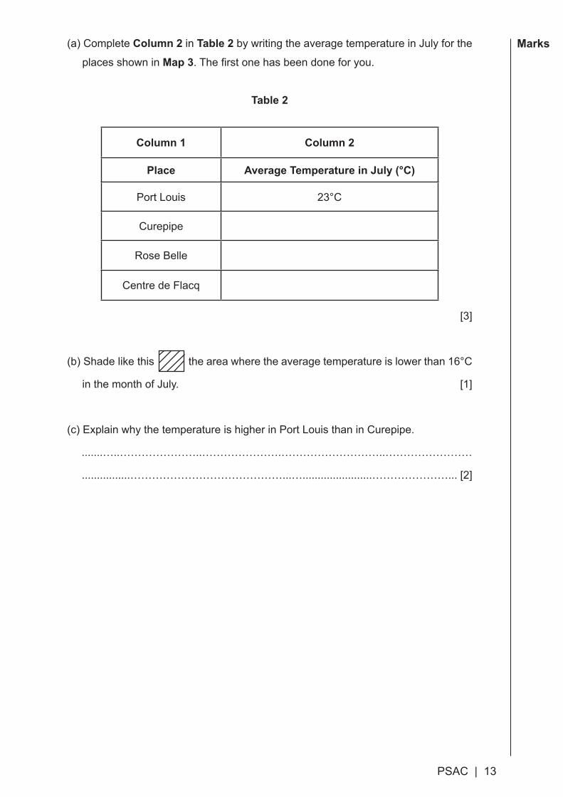
QUESTION 8 (6 marks)
Map 3 shows isotherms for the month of July in Mauritius. Study it carefully.
Map 3
AO: Application of knowledge and skills – read, extract and interpret information presented in a map;L.Os: Read and interpret isotherm maps; skills of handling information; drawing/graphic skills. Unit4/topic1pp.58,59,60

PSAC | 13
MarksMarks (a)CompleteColumn 2 in Table 2 by writing the average temperature in July for the
places shown in Map 3.Thefirstonehasbeendoneforyou.
Table 2
Column 1 Column 2
Place Average Temperature in July (°C)
Port Louis 23°C
Curepipe
Rose Belle
Centre de Flacq
[3]
(b)Shadelikethis theareawheretheaveragetemperatureislowerthan16°C
in the month of July. [1]
(c)ExplainwhythetemperatureishigherinPortLouisthaninCurepipe.
.......…..…………………..………………….………………………..……………………
................……………………………………...….......................…………………... [2]
14|PSAC
Marks
Blank Page
PSAC | 1
Marks
HIS
TOR
Y &
GE
OG
RA
PH
Y(SubjectCodeNoP142/1/R)
mauritiusexaminationssyndicatemauritiusexaminationssyndicatemauritiusexaminationssyndicatemauritiusexaminationssyndicatemauritiusexaminationssyndicatemauritiusmauritiusexaminationssyndicatemauritiusexaminationssyndicatemauritiusexaminationssyndicatemauritiusexaminationssyndicatemauritiusexaminationssyndicatemauritiusmauritiusexaminationssyndicatemauritiusexaminationssyndicatemauritiusexaminationssyndicatemauritiusexaminationssyndicatemauritiusexaminationssyndicatemauritiusmauritiusexaminationssyndicatemauritiusexaminationssyndicatemauritiusexaminationssyndicatemauritiusexaminationssyndicatemauritiusexaminationssyndicatemauritiusmauritiusexaminationssyndicatemauritiusexaminationssyndicatemauritiusexaminationssyndicatemauritiusexaminationssyndicatemauritiusexaminationssyndicatemauritiusmauritiusexaminationssyndicatemauritiusexaminationssyndicatemauritiusexaminationssyndicatemauritiusexaminationssyndicatemauritiusexaminationssyndicatemauritiusmauritiusexaminationssyndicatemauritiusexaminationssyndicatemauritiusexaminationssyndicatemauritiusexaminationssyndicatemauritiusexaminationssyndicatemauritiusmauritiusexaminationssyndicatemauritiusexaminationssyndicatemauritiusexaminationssyndicatemauritiusexaminationssyndicatemauritiusexaminationssyndicatemauritiusmauritiusexaminationssyndicatemauritiusexaminationssyndicatemauritiusexaminationssyndicatemauritiusexaminationssyndicatemauritiusexaminationssyndicatemauritiusmauritiusexaminationssyndicatemauritiusexaminationssyndicatemauritiusexaminationssyndicatemauritiusexaminationssyndicatemauritiusexaminationssyndicatemauritiusmauritiusexaminationssyndicatemauritiusexaminationssyndicatemauritiusexaminationssyndicatemauritiusexaminationssyndicatemauritiusexaminationssyndicatemauritiusmauritiusexaminationssyndicatemauritiusexaminationssyndicatemauritiusexaminationssyndicatemauritiusexaminationssyndicatemauritiusexaminationssyndicatemauritiusmauritiusexaminationssyndicatemauritiusexaminationssyndicatemauritiusexaminationssyndicatemauritiusexaminationssyndicatemauritiusexaminationssyndicatemauritiusmauritiusexaminationssyndicatemauritiusexaminationssyndicatemauritiusexaminationssyndicatemauritiusexaminationssyndicatemauritiusexaminationssyndicatemauritiusmauritiusexaminationssyndicatemauritiusexaminationssyndicatemauritiusexaminationssyndicatemauritiusexaminationssyndicatemauritiusexaminationssyndicatemauritius
Index Number: .........................................................
MAURITIUS EXAMINATIONS SYNDICATE
Primary School Achievement Certificate AssessmentSpecimen Assessment Booklet for Grade 5 from 2017 (Rodrigues)
Time: 1 hour Total marks: 50
INSTRUCTIONS TO CANDIDATES
1. Check that this assessment booklet contains 8 questions printed on 12 pagesnumbered2,3,4,5,6,7,8,9,10,11,12and13.
2. Write your Index Number on the assessment booklet in the space provided above.
3. You should not use red, green or black ink in answering questions.
4. Write all your answers clearly in the assessment booklet.
5. Attempt all questions.
QuestionMarking Revision Control
Marks Sig Marks Sig Marks Sig
1
2
3
4
5
6
7
8
TOTAL
Signature(HoG)
2 | PSAC
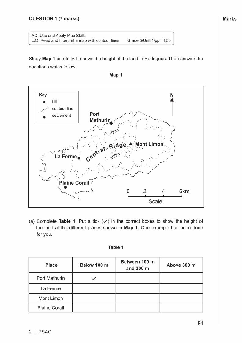
MarksQUESTION 1 (7 marks)
Study Map 1 carefully. It shows the height of the land in Rodrigues. Then answer the
questions which follow.
Map 1
(a) CompleteTable 1. Put a tick (✓) in the correct boxes to show the height of the land at the different places shown in Map 1. One example has been done for you.
Table 1
Place Below 100 m Between 100 m and 300 m Above 300 m
Port Mathurin ✓
La Ferme
Mont Limon
Plaine Corail
[3]
Scale
0 2 4 6km
hill
contour line
settlement
100m
100m
300m
Key
Central Ridge
PortMathurin
La Ferme
Mont Limon
Plaine Corail
AO:UseandApplyMapSkillsL.O:ReadandInterpretamapwithcontourlinesGrade5/Unit1/pp.44,50
PSAC | 3
MarksMarks (b)CircleletterA, B, C or D to show the correct answer.
(i)InwhatdirectionisPlaineCorailfromMontLimon?
A North East B South East
C South West D North West [1]
(ii)ThedistancealongastraightlinefromLaFermetoMontLimonisabout
A 2 km B4km C 6 km D 8 km [1]
(c)OntheCentralRidge,insomeplacessuchasLaFerme,theundulatinglandsaremadeoftuffs.Howweretuffsformed?
…………………………………………………………………………………………
………………………………………………………….………………..……………
[2]
Givethedirectionofoneplacefromanother pp.27,44,50
Makeuseofscaletomeasuredistancesonamap pp.26,44,50
AO: Construct explanationsL.O:Describeavolcanoineruption(p.29)/understandtheformationofrelieffeaturesofMauritius(pp.38,40)

4|PSAC
MarksQUESTION 2 (6 marks)
For items 1 to 6, circle the letter which shows the correct answer.
1. Study Diagram 1 carefully. It shows a volcano in eruption.
Diagram 1
Part Q is the
A pipe. B volcanic cone. C magma chamber. D crater.
2.AtwhichpartoftheEarthisithottestthroughouttheyear?
A South Pole
B Tropic of Cancer
C Tropic of Capricorn
D Equator
3. The large areas of deep seas on the Earth’s surface are called
A oceans.
B hemispheres.
C islands.
D continents.
Deep insidethe earthQ
AO:Knowledgeoffacts(Unit1:items1,2and3)andunderstandingofconcepts(Unit4:item4)

PSAC | 5
MarksMarks 4.Reliefrainoccurswhen
A it is cooler at night.
B the temperature of the sea is warm.
C air rises and condenses during the day in summer.
D air is forced to rise over highland areas.
Study Picture 1 carefully. It shows a natural forest in a highland area.Then answer items 5 and 6.
Picture 1
5.InwhichpartofMauritiuscanwefindsuchanaturalforest?
A On the Central Plateau
B In coastal areas
C On the Northern Plains
D At the mouth of rivers
6. The best way to protect a natural forest is to
A build a tourist hotel there.
B create a nature reserve.
C set up a timber factory.
D link it directly to the airport.AO: Application of knowledge – read and interpret information from a picture in GeographyL.Os: Explain the importance of a nature reserve; realise thatthenaturalenvironmentisimportantUnit1:pp.55,57

6 | PSAC
MarksQUESTION 3 (7 marks)
For items 1 to 7, circle the letter which shows the correct answer.
Study Map 2 carefully. It shows the sea routes taken by the Portuguese and Dutch sailorsinthepastfromEuropetotheEastIndies.Thenansweritems1to4.
Map 2
1. Continent X is
A Europe. B Africa.
C Asia. D Australia.
2.ThePortuguesesailorwhofirstsailedroundtheCapeofGoodHopeand
reachedIndiain1498was
A Diogo Rodriguez. B Pedro Mascarenhas.
C Vasco da Gama. D Van Warwick.
Cape of Good Hope
MascareneIslands
Portugal
Holland
India
East Indies
AO: Knowledge of facts and understanding of concepts; read and interpret a map in History (items1,2,3,4)Unit2pp.68,70,83
Key sea route taken by the Portuguese
sea route taken by the Dutch

PSAC | 7
MarksMarks 3. On their way to the East Indies, the Dutch sailors stopped in
A Madagascar.B the Mascarene islands.C India. D Australia.
4.Inthepast,theEuropeansailorswenttotheEastIndiesmainlytobuy
A coffee. B gold.C tea. D spices.
5. In 1715, the French took possession of Mauritius because they needed
A a safe harbour for their ships.B ebony wood to export to Europe.C tortoises from the island of Rodrigues.D slaves for Bourbon Island.
6.WhowastheFrenchOfficerinchargeofRodrigueswhentheBritishtroopscapturedtheislandin1809?
A François LeguatB Mathurin BrehinierC Philibert MarragonD Charles Decaen
7.DuringthefirstyearsofBritishruleinMauritius,SirRobertFarquharencouraged the planters to cultivate
A coffee. B indigo.C sugar cane.D tea.
AO: Knowledge of facts and understanding of conceptsItem 5: unit 3 /topic 2 L.O: Give reasons for the French settlement pp.22Item6:unit3/topic3 L.O:NametheofficerinchargeofRodrigues pp.36,38,92Item7/unit3/topic4 L.O:DiscusstheactivitiesofSirRFarquhar p.48

8 | PSAC
MarksQUESTION 4 (6 marks)
Pictures 2(a), 2(b) and 2(c) show three buildings which we can still see in
Port Louis.
Picture 2(d) shows one building which still exists in Port Mathurin today.
(a)Writethenameofeachbuildingbelowitspicture.Choosefromthegivenlist
of names.
La Résidence Old Granary Old Hospital
Post Office Government House
Picture 2(a) Picture 2(b)
(1)……………………………………… (2)………………………………………
Picture 2(c) Picture 2(d)
(3)……………………………………… (4)………………………………………[4]
(b)Explain why it is important to protect and embellish these buildings.
…………………………………………………………………………………………
………………………………………………………….………………..……………
[2]
AO: Select and Apply knowledgeL.O:ListafewbuildingsinPortLouis(andPortMathurin)andidentifytheirusesUnit5/topic1p.86

PSAC|9
MarksMarks QUESTION 5 (4 marks)
Fill in the blanks in sentences (a) to (e). Choose from the list of words below:
prevailing summer leeward
windward winter pollution isotherm
The first one has been done for you.
(a)Alineonamapjoiningplaceshavingthesametemperatureiscalledan
…………………………… .
(b)Convectionalrainoccursmainlyinthe………………………………season.
(c)TheSouthEastTradeWindsarecalled………......…………………winds.
(d)PortMathurinisfoundonthe…………………..…………sideofRodrigues.
(e)Climatechangeiscausedmainlyby……..…………………………..of
the atmosphere.
[4]
isotherm
AO:Knowledgeoffactsandunderstandingofconcepts Unit4L.Os: Recall the instrument for measuring temperature - recap p.55Describe the formation of convectional rain and relief rain pp.65, 66Describewhatcausesclimatechange p.74

10 | PSAC
MarksQUESTION 6 (5 marks)
Fill in the blanks (a) to (e) in the short story about some of the achievements of French administrator Pierre Poivre in Ile de France.
Choose from this list of words:
ships slaves sugar cane spice rivers agriculture land
Pierre Poivre had travelled to China and to South East Asia. On his way to France
in 1753, he brought (a) ………………………………… plants to Ile de France.
When he became the administrator of Ile de France in 1767, Pierre Poivre
encouraged the French settlers to develop (b) …………..…...…………………….
He gave plots of (c) ……………………………… to other free people to develop the
town of Port Louis.
But without the hard work of the (d) ……..……………………………, Ile de France
would not have become a prosperous colony.
Pierre Poivre took important measures to protect the natural environment.
For example, he ordered the indigo factories to stop polluting the
(e) ……………..................…… and canals on the island.
[5]
AO:Applicationofknowledge-SelectandApplyknowledge Unit3/topic2.5pp.29,31L.O: State the contribution of Pierre Poivre in the development of agricultureGeneralObjective:Showaninterestinfindingoutaboutthepast
PSAC | 11
MarksMarks QUESTION 7 (9 marks)
1. Picture 3 shows the place in the area of Grand Port where Dutch sailors landed for the first time in Mauritius. Study it carefully. Then answer questions (a) and (b).
Picture 3
(a)WhatisthenameoftheplacewheretheDutchsailorslandedforthefirsttimein
1598?CircleletterA, B or C to show the correct answer.
A Vieux Grand Port B Ferney C Mahebourg [1]
(b)Describetwo activities of the Dutch sailors which are shown in Picture 3.
(i) …..…………………..………………….………………………..……………………
...............……………………………………...….......................…………………... [2]
(ii)…..…………………..………………….………………………..……………………
...............……………………………………...….......................…………………... [2]
2. Describe two advantages that the area of Grand Port offered to the Dutch settlers.
(i) …..…………………..………………….………………………..……………………
...............……………………………………...….......................…………………... [2]
(ii)…..…………………..………………….………………………..……………………
...............……………………………………...….......................…………………... [2]
AOs:Applicationofskills-readandinterpretahistoricalsource/document(a)and(b)selectandapplyknowledge(part2)L.Os: Locate the place where the Dutch settled and its advantages; describe the activities of theDutch:Unit2/topic3p.72andunit3/topic1,pp.8-11
12 | PSAC
MarksQUESTION 8 (6 marks)
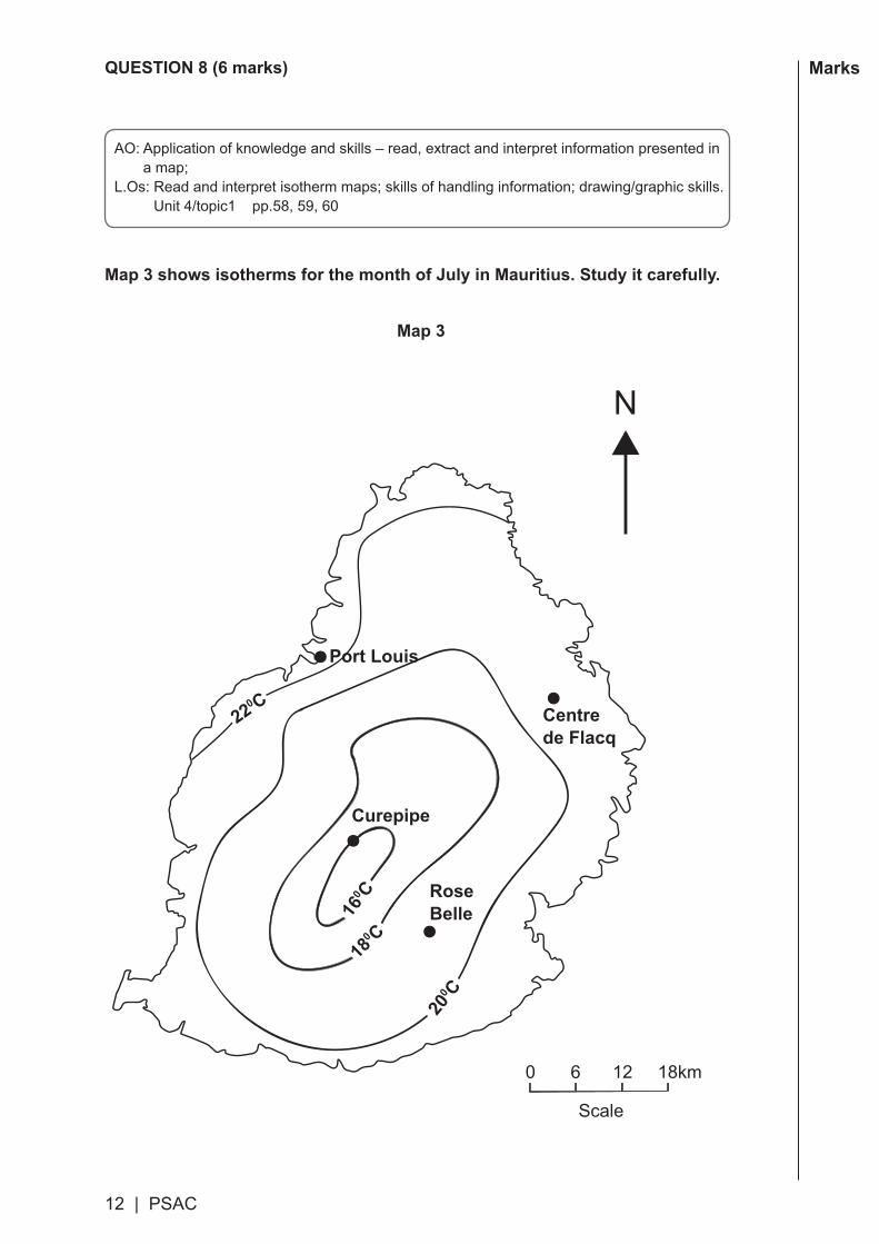
Map 3 shows isotherms for the month of July in Mauritius. Study it carefully.
Map 3
AO: Application of knowledge and skills – read, extract and interpret information presented in a map;L.Os: Read and interpret isotherm maps; skills of handling information; drawing/graphic skills. Unit4/topic1pp.58,59,60
Centrede Flacq
Port Louis
Curepipe
RoseBelle
Scale
0 6 12 18km
220 C
160 C
180 C
200 C
PSAC | 13
MarksMarks (a)CompleteColumn 2 in Table 2 by writing the average temperature in July for the
places shown in Map 3.Thefirstonehasbeendoneforyou.
Table 2
Column 1 Column 2
Place Average Temperature in July (°C)
Port Louis 23°C
Curepipe
Rose Belle
Centre de Flacq
[3]
(b)Shadelikethis theareawheretheaveragetemperatureislowerthan16°C
in the month of July. [1]
(c)ExplainwhythetemperatureishigherinPortLouisthaninCurepipe.
.......…..…………………..………………….………………………..……………………
................……………………………………...….......................…………………... [2]

Blank Page

SPECIMEN MARK SCHEME
Mauritius Examinations Syndicate
PRIMARY SCHOOLACHIEVEMENT CERTIFICATE
Note: This mark scheme is provided for guidance purposes only and does not provide an exhaustive list of all acceptable answers.
Specimen Assessment Booklet
2017February
HISTORY & GEOGRAPHY


PSAC | 1
Question 1 (Mauritius)
(a) GiveONE mark to a tick as follows:
Place Below than 200 m Between 200 m and 400 m Above 400 m
Port Louis ✓
Quatre Bornes ✓
Curepipe Point ✓
Le Morne ✓
(b) (i)C (ii)C (c) Two marksto:bylavaflowsfromvolcanoes/craters Bylavaflowswhichhavesolidified;solidifiedlavaflows Giveonemarkonlyto:byvolcanoes;bylavaflows
Question 1 (Rodrigues)
(a) GiveONE mark to a tick as follows:
Place Below 100 m Between 100 m and 300 m Above 300 m
Port Mathurin ✓
La Ferme ✓
Mont Limon ✓Plaine Corail ✓
(b) (i)C (ii)C
(c) Two marks to: by ash and dust from volcanoes/craters Byashanddustwhichhavesolidified;solidifiedashanddust By ash and dust deposited; ash and dust deposits Give one mark only to: by volcanoes; by ash and dust
1
1
1
1
1
1
1
2
7
1
1
1
2
7
2 | PSAC
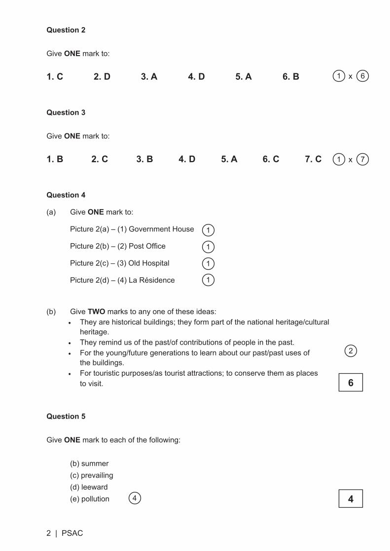
Question 2
Give ONE mark to:
1. C 2. D 3. A 4. D 5. A 6. B
Question 3
Give ONE mark to:
1. B 2. C 3. B 4. D 5. A 6. C 7. C
Question 4
(a) Give ONE mark to:
Picture2(a)–(1)GovernmentHouse
Picture2(b)–(2)PostOffice
Picture2(c)–(3)OldHospital
Picture2(d)–(4)LaRésidence
(b) GiveTWO marks to any one of these ideas:• They are historical buildings; they form part of the national heritage/cultural
heritage.• They remind us of the past/of contributions of people in the past.• For the young/future generations to learn about our past/past uses of
the buildings.• For touristic purposes/as tourist attractions; to conserve them as places
to visit.
Question 5
Give ONE mark to each of the following:
(b)summer (c)prevailing (d)leeward (e)pollution
1 6x
1
1
1
1
4
1 7x
2
6
4

PSAC | 3
Question 6
Give ONE mark to each of the following:
(a)spice
(b)agriculture
(c)land
(d)slaves
(e)rivers
Question 7
1.(a) B
(b) GiveTWO marks each to any two of the following:
• Theyare/werefishingforfood
• They built a hut/huts
• One sailor is/was cooking food
• They were building/repairing a boat
• They have cut/were cutting wood
• One sailor is/was mending/repairing/making barrels
• They held/were holding an assembly under a tree
• They did/were doing iron works; they were heating and moulding iron
Give one mark to a one word answer such as:
• Fishing/building/repairing
Wrong answers
No mark to:
• Cutting down ebony trees/forest
• Growing/planting fruit trees/vegetables/other crops
• Rearing cattle/animals
• Huntingtortoises/birds/dodos(notshowninthispictureonDutchfirstlanding)
5
1
1
2 2x
5
4|PSAC
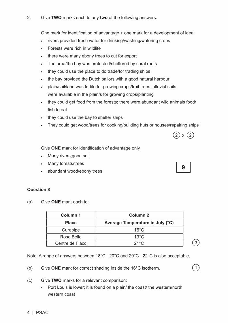
2. Give TWO marks each to any two of the following answers:
Onemarkforidentificationofadvantage+onemarkforadevelopmentofidea.
• rivers provided fresh water for drinking/washing/watering crops
• Forests were rich in wildlife
• there were many ebony trees to cut for export
• The area/the bay was protected/sheltered by coral reefs
• they could use the place to do trade/for trading ships
• the bay provided the Dutch sailors with a good natural harbour
• plain/soil/land was fertile for growing crops/fruit trees; alluvial soils
were available in the plain/s for growing crops/planting
• they could get food from the forests; there were abundant wild animals food/
fishtoeat
• they could use the bay to shelter ships
• They could get wood/trees for cooking/building huts or houses/repairing ships
Give ONEmarkforidentificationofadvantageonly• Many rivers;good soil
• Many forests/trees
• abundant wood/ebony trees
Question 8
(a) GiveONE mark each to:
Column 1 Column 2Place Average Temperature in July (°C)
Curepipe 16°CRose Belle 19°C
Centre de Flacq 21°C
Note: A range of answers between 18°C - 20°C and 20°C - 22°C is also acceptable.
(b) GiveONE mark for correct shading inside the 16°C isotherm.
(c) GiveTWO marks for a relevant comparison:• Port Louis is lower; it is found on a plain/ the coast/ the western/north
western coast
2 2x
9
3
1

PSAC | 5
• Curepipe is higher/found on high land/ higher lands or location
• The altitude of Port-Louis is lower/low whereas Curepipe is at a higher/high
altitude
• Port-Louis/It is found at/on low/lower altitude
• Because the lower the place, the warmer it gets
• The higher we go, the cooler it gets.
• Because temperature of the air changes/varies with altitude/height
Give one mark to:
• Limited development of answer such as it is low; a low place; on leeward side
2
1
6

6 | PSAC

PSAC | 7

Mauritius Examinations Syndicate
© Mauritius Examinations SyndicatePSAC specimen booklet Grade 5February 2017
HISTORY & GEOGRAPHYSpecimen Assessment Booklet
GRADE 5
February
2017
PRIMARY SCHOOLACHIEVEMENT CERTIFICATE
This document contains the History & Geography assessment booklet forcandidates who will take the Grade 5 PSAC assessment in 2017. It also containsthe explanatory notes which include useful information on the modular assessmentfor this subject as well as the specimen mark scheme. The Assessment Objectivesand Learning objectives/learning outcomes for each question have been insertedin boxes for ease of reference.