historical markers & monumentsbradfordhistory.com/usr/pdfs/bchsmonumentguideuse.pdfhistorical...
TRANSCRIPT

A Traveler’s Guide to
BRADFORD COUNTYHISTORICAL MARKERS & MONUMENTS
Featuring Over 80 Markers Complete with Interesting Details, GPS Coordinates, and Historical Photographs.
Bradford County Historical Society, Towanda, Pennsylvaniawww.bradfordhistory.com
Edited by Matthew T. Carl, BCHS Curator & Manager
Native Americans, Music, French Asylum, Medicine,Military, Notable People, Transportation and much more!

Copyright 2014. Bradford County Historical Society109 Pine Street, Towanda, PA 18848
All Rights Reserved. No part of this guide may be repro-duced or transmitted in any form or by any means, elec-tronic or mechanical, including photocopying, recording,or by any information storage or retrieval system withoutprior written permission from the Bradford County Histor-ical Society, or its agent, except for inclusion of brief quo-tations in a review.
This project was made possible by the Bradford CountyRoom Tax Fund and the Endless Mountains Visitors Bu-reau.
For more information about Bradford County history, visitthe Bradford County Historical Society Museum and Re-search Center at 109 Pine Street, Towanda, Pennsylvania;call 570-265-2240; or visit us online at www.bradfordhis-tory.com.

This guide was produced by the Bradford County Historical So-ciety in an effort to update the information and directions that areavailable for travelers who wish to visit the roadside historical siteslocated throughout the county. Bradford County is the second largest county in the Common-wealth of Pennsylvania in terms of land area. There are numeroushistorical sites within the county and over the years both local cit-izens and state agencies have marked many of these sites. It has
been our intention to high-light the markers that arerelevant to the county as awhole. Many otherplaques and monumentscan be found throughoutthe county, placed by localtowns, organizations andindividuals in publicparks, cemeteries, andother locations wheremore localized historicalsites or events are com-
memorated. Many more permanent memorials are erected on a reg-ular basis. We have not included these markers as the list would betoo extensive. The Bradford County Historical Society has worked to markhistorical sites over the years and several markers listed bear ourname. The Society continues to watch over and care for many
i
INTRODUCTION

ii
markers today. The overall responsibility of the maintenance of theblue roadside markers and several of the plaques on bouldersthroughout the county belongs to the Pennsylvania Historical andMuseum Commission. Please note that some of the markers listed in this guide weremissing at the time of publication. These markers are identifiedwhere necessary. The theft of historical plaques and markers is acrime that carries severe penalities. Recycling facilities are requiredto report persons who attempt to turn in these materials. If you seeunusual activity around amarker, contact the BradfordCounty Historical Society. Each marker in this guide hasdirections as well as GPS coor-dinates to further pinpoint the lo-cation of the monument. Theyhave been listed topically so thatthe user may locate all monu-ments or markers pertaining totheir particular interest. The firstseveral words of text for each marker will be found in this guide.The full text of each marker can be found by visiting the locationin person or by searching the Bradford County Historical Societywebsite at www.bradfordhistory.com. You may also scan the QRcode above with your Smartphone or iPhone QR code reader appto visit the Historical Marker page on the BCHS website where youcan read the full text of many of the markers and monuments inBradford County.
Scan this QR code with your Smartphoneor iPhone QR code reader app to read thefull text of many of the historical markersand monuments in this guide.

iii
City, County & State..................................................1
French Asylum...........................................................3
Medicine.....................................................................6
Military - Battle of Lime Hill.....................................7
Military - Hartley’s Expedition..................................9
Military - Sullivan’s Expedition..............................12
Military - War Memorials........................................19
Music........................................................................27
Native Americans.....................................................29
Notable People.........................................................35
Public Service..........................................................36
Religion....................................................................37
Transportation..........................................................37
Utilities.....................................................................38
TABLE OF CONTENTS

iv
DEFINITIONS
BCHS – Bradford County Historical SocietyDAR – Daughters of the American RevolutionPENNDOT – Pennsylvania Department of TransportationPHC – Pennsylvania Historical CommissionPHMC – Pennsylvania Historical & Museum Commission
MARKER TYPES
PLAQUE – Typically a bronze plaque on a boulder or building.ROADSIDE – Typically a blue and yellow historic marker along a highway.ENGRAVED STONE – A stone with the words carved directly into its face.STATUE – A carved or cast figure of a person or persons with or without a plaque attached.
COORDINATES
To save space, the coordinates of North, South, East and West have been short-ened to the letters N, S, E, and W.

CITY, COUNTY & STATE
AthensDedicated: Monday, May 12, 1947 Erected By: PHMCMarker Type: RoadsideLocation: PA 199 at Tioga Point Cemetery, AthensGPS Coordinates: LAT: 41.972478, LNG: -76.523695Marker Text: Known also as Tioga Point…
Bradford CountyDedicated: Saturday, July 10, 1982 Erected By: PHMCMarker Type: Roadside Location: Inside the County Courthouse, Main Street, TowandaGPS Coordinates: LAT: 41.767083, LNG: -76.44293Marker Text: Formed on February 21, 1810 from Lycoming and Luzerne counties…
MilltownDedicated: 1983Erected By: Valley Railroad Museum Association & PennDOTMarker Type: RoadsideLocation: Cayuta Street, Sayre, near the Milltown bridgeGPS Coordinates: LAT: 41.993592, LNG: -76.517903
1
BRADFORD COUNTY HISTORICALMARKERS & MONUMENTS
Marker Text: Prince Bryant’s gristmill became Shepards mill in 1788…
PennsylvaniaDedicated: Thursday, June 10, 1948 Erected By: PHMCMarker Type: RoadsideLocation: PA 14, 1.5 miles from state line (MISSING)GPS Coordinates: LAT: 41.99928, LNG: -76.77724Marker Text: Founded 1681 by William Penn as a Quaker Commonwealth…
PennsylvaniaDedicated: Tuesday, September 27, 1949 Erected By: PHMCMarker Type: RoadsideLocation: US 220 & 309, .3 miles from state line (MISSING)GPS Coordinates: LAT: 41.998172; LNG: -76.548786Marker Text: Founded 1681 by William Penn as a Quaker Commonwealth…
Pine PlainsDedicated: Monday, May 12, 1947 Erected By: PHMCMarker Type: RoadsideLocation: PA 199 at First Church of God, SayreGPS Coordinates: LAT: 41.9909228, LNG: -76.528662Marker Text: This area was known by pioneers as the “Pine Plains”…
WyalusingDedicated: Tuesday, March 15, 1949 Erected By: PHMCMarker Type: RoadsideLocation: US 6 at S end of Wyalusing2
GPS Coordinates: LAT: 41.66488, LNG: -76.25985Marker Text: Named for an early town of the Munsee Delawares…
WyalusingDedicated: August 5, 1914Erected By: DARMarker Type: Plaque on boulderLocation: Wyalusing Cemetery, 1 mile off US 6 on PA 2010, beside Wyalusing High SchoolGPS Coordinates: LAT: 41.659816, LNG: -76.255829Marker Text: Near this site from August 5-8, 1779 camped the army of Major General John Sullivan…
WyalusingDedicated: Tuesday, March 15, 1949 Erected By: PHMCMarker Type: RoadsideLocation: US 6 at N end of WyalusingGPS Coordinates: LAT: 41.670845, LNG: -76.270015Marker Text: Named for an early town of the Munsee Delawares…
FRENCH ASYLUM
AsylumDedicated: June 14, 1916Erected By: John W. Mix and Charles d’Autremont, Jr. Presented to BCHS who owns the land on which the monument is located.Marker Type: Plaque on boulderLocation: Off PA 187, corner of French Asylum Road and Queen’s RoadGPS Coordinates: LAT: 41.731643, LNG: -76.31164Marker Text: This monument is erected to commemorate…
3

4
The photo above was taken at the dedication of the Asylum monument in 1916. Thephoto below shows Madame P.P. Myer with Angelique, Jane and Billy Spalding, de-scendants of the French refugees.

AsylumDedicated: June, 1930 Erected By: PHC & BCHSMarker Type: Plaque on boulderLocation: US 6, 4.5 miles N of Wyalusing at lookoutGPS Coordinates: LAT: 41.731075, LNG: -76.297496Marker Text: A settlement of French Royalists who fled the French Revolution in 1793…
AzilumDedicated: Monday, May 12, 1947 Erected By: PHMCMarker Type: RoadsideLocation: US 6, 4.5 miles N of Wyalusing at lookoutGPS Coordinates: LAT: 41.730446, LNG: -76.296709Marker Text: The broad plain which can be seen from this point was the site, 1793-1803, of the French refugee colony…
5
A postcard image showing the monument for Asylum at the lookout along US 6. Apostcard depicting the lookout in the 1930’s can be found on page 6.

AzilumDedicated: Monday, May 12, 1947 Erected By: PHMCMarker Type: RoadsideLocation: Junction US 6 & PA 187 at WysoxGPS Coordinates: LAT: 41.7744, LNG: -76.39787Marker Text: Site of the famed French refugee colony is a few miles south…
MEDICINE
Guthrie SquareDedicated: 1957Erected By: Sayre Borough CouncilMarker Type: Plaque on boulderLocation: Elmer Park, South Elmer Avenue, SayreGPS Coordinates: LAT: 41.980481, LNG: -76.518591Marker Text: Named to honor Dr. Donald Guthrie who for many years has been Surgeon-In-Chief of the Robert Packer Hospital - Guthrie Clinic...
6
MILITARY – BATTLE OF LIME HILL
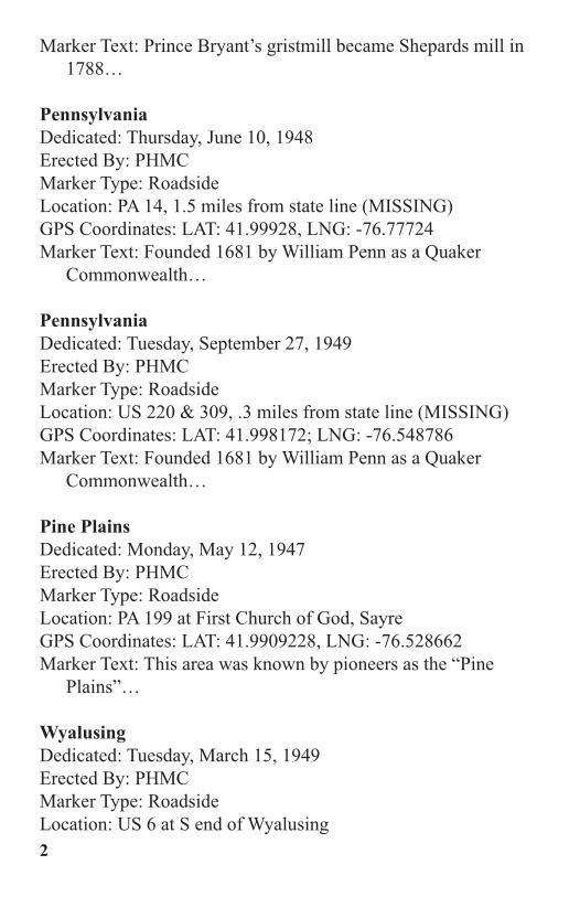
Joseph ElliottDedicated: October 5, 1929Erected By: Joseph Elliott Descendants Marker Type: Plaque on boulder (reverse of Lime Hill monument, see page 8)Location: US 6, 3.7 miles N of Wyalusing GPS Coordinates: LAT: 41.72338, LNG: -76.2909Marker Text: Second in command at the Battle of Lime Hill April 14, 1782…
Lime HillDedicated: Monday, May 12, 1947 Erected By: PHMCMarker Type: RoadsideLocation: US 6 at Limehill, 3.7 miles N of WyalusingGPS Coordinates: LAT: 41.72338, LNG: -76.2909Marker Text: Here Apr. 14, 1782, a party led by Sgt. Thomas Baldwin…
7
Dedication of the Joseph Elliott plaque on the back of the Lime Hill Battlefieldmonument in 1929.

Lime Hill BattlefieldDedicated: Thursday, November 01, 1928 Erected By: PHC & BCHSMarker Type: Plaque on boulderLocation: US 6, 3.7 miles N of Wyalusing GPS Coordinates: LAT: 41.72338, LNG: -76.2909Marker Text: April 14, 1782, Sergeant Thomas Baldwin’s Party in attempting to rescue Mrs. Roswell Franklin…
See also NATIVE AMERICANS.8
The Lime Hill Battlefield monument is unveiled in 1928 by Mrs. Arminda ElliottFisher, great grand-daughter of Joseph Elliott who was second in command, andMiss Harriet Baldwin, great-great grand-daughter of Thomas Baldwin who com-manded the rescuing party.

MILITARY – HARTLEY’S EXPEDITION
Colonel Thomas HartleyDedicated: 1921Erected By: DARMarker Type: Plaque on boulderLocation: PA 14, one mile S of Canton Borough at Cedar LedgeGPS Coordinates: LAT: 41.638495, LNG: -76.870572Marker Text: Near this spot, September 26, 1778, Colonel Thomas Hartley…
9
Colonel Thomas Hartley monument at Cedar Ledge, south of Canton, in 1921.

10
Indian HillDedicated: Monday, May 12, 1947 Erected By: PHMCMarker Type: RoadsideLocation: US 6, 4.6 miles E of WyalusingGPS Coordinates: LAT: 41.67442, LNG: -76.19231
The Indian Hill Battlefield monument is unveiled in 1928 by Clara Walker Bonfoey(left), great-great-great grand-daughter of Col. John Franklin, and Adelaide KenneyRice, great-great-great grand-daughter of Gen. Simon Spaulding. Both Franklinand Spaulding were prominent figures in the Hartley Expedition.

Marker Text: The hill just southeast was the scene, Sept. 29, 1778, of a battle…
Indian Hill BattlefieldDedicated: October 13, 1928 Erected By: PHC & BCHSMarker Type: Plaque on boulderLocation: Off US 6, E of Wyalusing, at Cornell Road, first right past Indian Hill blue marker traveling eastGPS Coordinates: LAT: 41.671684, LNG: -76.189394Marker Text: On September 29th, 1778 on the hill one mile south east…
Battle of Indian Hill on this SiteDedicated: 1999 Erected By: DAR & Tuscarora Township Historical SocietyMarker Type: Engraved stoneLocation: Off US 6, E of Wyalusing, at Cornell Road, make a second turn on to Singer Road GPS Coordinates: LAT: 41.657287; LNG: -76.179398Marker Text: During the only Revolutionary battle fought in
11
Site of the Indian Hill Battlefield in Tuscarora Township as it appeared on October6, 1916. Here, Colonel Hartley’s forces defeated the Indians, September 29, 1778.Hill occupied by Hartley, in distance, showing slope over which the Indians ad-vanced.

Bradford County…
See also NATIVE AMERICANS.
MILITARY – SULLIVAN’S EXPEDITION
Colonel John FranklinDedicated: Monday, September 23, 1946 Erected By: PHMCMarker Type: RoadsideLocation: PA 1043 Riverside Drive, 1.2 miles SE of Athens at cemeteryGPS Coordinates: LAT: 41.94998, LNG: -76.50132Marker Text: Leader of Connecticut land claimants. Served in Sullivan Campaign, 1779…
Fort SullivanDedicated: Monday, May 12, 1947 Erected By: PHMCMarker Type: RoadsideLocation: PA 199 Athens near the intersection of South Main Street and Tioga Point LaneGPS Coordinates: LAT: 41.948934; LNG: -76.515912Marker Text: Here, between the Chemung and Susquehanna commanding both rivers, Gen. John Sullivan built a fort…
Fort SullivanDedicated: October 3, 1902Erected By: DARMarker Type: Plaque on boulderLocation: South Main Street, Athens, nearly opposite the Spalding Memorial LibraryGPS Coordinates: LAT: 41.950624; LNG: -76.516034Marker Text: In Sullivan’s Expedition, the march that destroyed savagery…12

13
An image of the Fort Sullivan monument on South Main Street, Athens. The mon-ument was dedicated in 1902.

Fort Sullivan “Soldiers’ Burial” Dedicated: 1929 Erected By: PHC & DARMarker Type: Plaque on boulderLocation: 731 Main Street, AthensGPS Coordinates: LAT: 41.950713, LNG: -76.516145Marker Text: Here within the confines of Fort Sullivan…
Sullivan Expedition Against the Iroquois Indians, 1779 -Breakneck HillDedicated: 1929Erected By: PHCMarker Type: Plaque on boulderLocation: Off US 220 between Towanda and Ulster (MISSING – Highway moved, plaque at BCHS)GPS Coordinates: LAT: 41.805466, LNG: -76.49497Marker Text: Narrow pass over which Sullivan's Army marched August 9, 1779 is visible across the river…
14
A postcard view showing the original site of the Sullivan Expedition monument titled,“Breakneck Hill”. When US 220 was built, the monument was removed.

Sullivan Expedition Against the Iroquois Indians, 1779 -Sheshecunnunck Dedicated: 1929 Erected By: PHCMarker Type: Plaque on boulderLocation: E side of SR 1043 in Sheshequin Township, 2.3 miles N of the Ulster bridgeGPS Coordinates: LAT: 41.88085, LNG: -76.50249Marker Text: 15 miles from Standing Stone, seventh and last encampment…
Sullivan Expedition Against the Iroquois Indians, 1779 -Standing Stone Dedicated: 1929 Erected By: PHCMarker Type: Plaque on boulderLocation: Off US 6 on SR 2016 River Road, at Standing Stone United Methodist ChurchGPS Coordinates: LAT: 41.74215, LNG: -76.33529Marker Text: 9 1/2 miles from Wyalusing, sixth encampment of Sullivan's army…
15
Dedication of the Sullivan Expedition monument at Standing Stone in 1929.

Sullivan Expedition Against the Iroquois Indians, 1779 -TeaogaDedicated: 1929 Erected By: PHC & DARMarker Type: Plaque on boulderLocation: East Main Street, Athens, opposite the Spalding
16
Dedication of the Sullivan Expedition monument at Athens in 1929.

Memorial LibraryGPS Coordinates: LAT: 41.951164, LNG: -76.51611Marker Text: Indian village 3 miles distant from Sheshecunnunck…
Sullivan Expedition Against the Iroquois Indians, 1779 -WyalusingDedicated: 1929 Erected By: PHCMarker Type: Plaque on boulderLocation: US 6, 1.4 miles SE of Wyalusing, near the corner of Moravian RoadGPS Coordinates: LAT: 41.65385, LNG: -76.23965Marker Text: 10 1/2 miles from Vanderlip's farm. Fifth encampment of Sullivan's Army…
Sullivan's MarchDedicated: Monday, May 12, 1947 Erected By: PHMCMarker Type: RoadsideLocation: US 6, 1.4 miles SE of WyalusingGPS Coordinates: LAT: 41.65373, LNG: -76.23943Marker Text: Gen. John Sullivan's army camped just west Aug. 5-7, 1779…
Sullivan's MarchDedicated: Monday, May 12, 1947 Erected By: PHMCMarker Type: RoadsideLocation: E side of PA 1043 in Sheshequin Township, 2.3 miles N of the Ulster bridge (MISSING)GPS Coordinates: LAT: 41.88085, LNG: -76.50249Marker Text: Gen John Sullivan's army camped on the Sheshequin Flats…
17

Sullivan's MarchDedicated: Monday, May 12, 1947 Erected By: PHMCMarker Type: RoadsideLocation: US 6, about 6.2 miles NW of Wyalusing, at Standing Stone Township BuildingGPS Coordinates: LAT: 41.74837, LNG: -76.3231Marker Text: Gen. John Sullivan's army camped on the nearby river lowlands…
Sullivan's MarchDedicated: Tuesday, March 15, 1949 Erected By: PHMCMarker Type: RoadsideLocation: US 220, 1.3 miles N of UlsterGPS Coordinates: LAT: 41.87128, LNG: -76.50963Marker Text: Gen. John Sullivan's army camped on the Sheshequin Flats below…
Sullivan's MarchDedicated: 1908 Erected By: DARMarker Type: Plaque on boulderLocation: PA 187, .25 miles N of the junction with US 6 at Wysox, boulder next to Wysox Presbyterian ChurchGPS Coordinates: LAT: 41.778255, LNG: -76.395593Marker Text: This stone commemorates the passing through Wesauking…
See also NATIVE AMERICANS.
18

MILITARY – WAR MEMORIALS
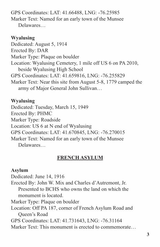
Athens Soldiers MemorialDedicated: 1900Erected By: Joseph Whipple and Charlotte Snell Stickler Marker Type: StatueLocation: PA 199 in Athens, opposite the Spalding Memorial LibraryGPS Coordinates: LAT: 41.951181, LNG: -76.516006Marker Text: Pro Patria Et Gloria. Erected to the memory of our soldiers who fought in defense of the flag…
19
A photo of the Sullivan’s March monument at the Wysox Presbyterian Church, takenat the dedication in 1908.

20
A postcard of the Athens Soldiers Memorial from the early 1900’s.
Athens Roll of HonorDedicated: 1957Erected By: Teaoga Chapter 11, American War DadsMarker Type: Plaque on boulderLocation: PA 199 in Athens, opposite the Spalding Memorial LibraryGPS Coordinates: LAT: 41.951096, LNG: -76.516158Marker Text: A tribute to the men of Athens Borough who made the supreme sacrifice in the wars of our country...
Athens Vietnam Veterans MemorialDedicated: UnknownErected By: Sons of the American Legion, Fort Sullivan Sqd. 246Marker Type: Plaque on boulderLocation: PA 199 in Athens, opposite the Spalding Memorial LibraryGPS Coordinates: LAT: 41.951095, LNG: -76.516155Marker Text: Dedicated to Vietnam veterans...
Blue Star MemorialDedicated: 2012Erected By: Heritage Garden Club of Troy in cooperation with the Bradford County Manor and the Garden Club Federation of PennsylvaniaMarker Type: RoadsideLocation: US 6 at Bradford County Manor, West BurlingtonGPS Coordinates: LAT: 41.7762, LNG: -76.623682Marker Text: A tribute to the Armed Forces that have defended the United States of America...
Bradford County Soldiers & Sailors Civil War MemorialDedicated: Tuesday, November 26, 1901Erected By: The Soldiers & Sailors Monumental Park Association of Bradford CountyMarker Type: Statue
21

Location: US 6 at Bradford County Courthouse, TowandaGPS Coordinates: LAT: 41.76712, LNG: -76.442915Marker Text: In Memory of the Soldiers and Sailors of Bradford County…
Bradford County Veterans MemorialDedicated: April 6, 2013Erected By: Bradford County Veterans Memorial Park AssociationMarker Type: [Variety of markers throughout the park.]Location: US 6, W end of the Veterans Memorial Bridge, TowandaGPS Coordinates: LAT: 41.761949, LNG: -76.442705Marker Text: [Variety of text throughout the park.]
Bradford County Veterans War MemorialDedicated: UnknownErected By: American Legion Post 42, Towanda
22
A postcard of the Bradford County Soldiers & Sailors Civil War monument on MainStreet, Towanda, in the 1920’s.

23
Marker Type: Plaque surrounded by flagsLocation: 912 Main Street, TowandaGPS Coordinates: LAT: 41.757582, LNG: -76.443416Marker Text: Bradford County veterans killed in combat...
Canton War MemorialDedicated: July 4, 1954Erected By: Canton War Memorial AssociationMarker Type: Engraved stone and flag poleLocation: Near entrance of Canton War Memorial Pool, Second Street, CantonGPS Coordinates: LAT: 41.653367, LNG: -76.847021Marker Text: Dedicated July 4, 1954 to the men and women of the Canton area who served our country in time of war...
GAR Civil War MemorialDedicated: May 30, 1868Erected By: Post 58, Department of Pennsylvania, Grand Army of the Republic (GAR)Marker Type: Engraved stoneLocation: Riverside Cemetery, William Street, TowandaGPS Coordinates: LAT: 41.775616, LNG: -76.442517Marker Text: This tablet was here placed on the thirtieth day of May, 1868…
Henry J. MadillDedicated: 1906Erected By: Members of the 141st Regiment, 6th Reserve; and patriotic citizens Marker Type: Engraved stoneLocation: Wysox Cemetery, PA 187, .25 miles N of the junction with US 6 at Wysox, behind the Wysox Presbyterian Church GPS Coordinates: LAT: 41.778369, LNG: -76.396371Marker Text: Distinguished hero of the Civil War. Born March 30, 1828. Died June 29, 1899…

24
A postcard view of the Henry J. Madill monument in the Wysox Cemetery.

25
Sayre World War I DoughboyDedicated: 1919 Erected By: Citizens of SayreMarker Type: StatueLocation: Elmer Park, South Elmer Avenue, SayreGPS Coordinates: LAT: 41.980477, LNG: -76.517409Marker Text: Their deeds are immortal – their memory shall never die… [There are a variety of plaques on this statue which have been added to commemorate other wars.]
Smithfield Civil War MemorialDedicated: September 14, 1871Erected By: Citizens of Smithfield Township Marker Type: Engraved stoneLocation: East Smithfield, at the intersection of Main Street and Church StreetGPS Coordinates: LAT: 41.86416, LNG: -76.625592Marker Text: This monument is erected by citizens of this
A postcard showing the Sayre World War I Doughboy monument in Elmer Park,Sayre, in about 1935.

township to perpetuate the memories of fifty-four of its soldiers...
Spanish American War Dedicated: Monday, May 12, 1947 Erected By: Captain Frank N. MooreMarker Type: Plaque on buildingLocation: US 6 at Bradford County Courthouse, TowandaGPS Coordinates: LAT: 41.767111, LNG: -76.442848Marker Text: In memory of Co. M, 9th Pennsylvania Volunteer Infantry…
Ulster Civil War MemorialDedicated: 1898 Erected By: Gilmour Post 227, Grand Army of the Republic (GAR)Marker Type: Engraved stoneLocation: James Street, off US 220, Ulster
2626
The Smithfield Civil War Memorial was dedicated in 1871 in remembrance of thesacrifices made by the citizens of Smithfield Township.
GPS Coordinates: LAT: 41.844271, LNG: -76.505405Marker Text: All honor due our nations defenders, 1861-1865…
World War IDedicated: 1923Erected By: DARMarker Type: Plaque on buildingLocation: US 6 at Bradford County Courthouse, TowandaGPS Coordinates: LAT: 41.767111, LNG: -76.442848Marker Text: In honor of the men and women of Bradford County who strove…
MUSIC
CamptownDedicated: Thursday, May 15, 1969 Erected By: PHMCMarker Type: RoadsideLocation: Junction PA 706 & 409 at Camptown (MISSING)GPS Coordinates: LAT: 41.729709, LNG: -76.23501Marker Text: Stephen Foster’s well-known song, “Camptown Races,”…
Camptown RacesDedicated: Monday, May 12, 1947 Erected By: PHMCMarker Type: RoadsideLocation: Junction US 6 & PA 409, 4.2 miles N of WyalusingGPS Coordinates: LAT: 41.72703, LNG: -76.29532Marker Text: Stephen Foster’s title for the well-known song…
Philip P. BlissDedicated: Monday, May 12, 1947 Erected By: PHMCMarker Type: Roadside
27

Location: PA 187 in Rome Borough at cemetery, across from churchGPS Coordinates: LAT: 41.864195, LNG: -76.335331Marker Text: The great singing evangelist and gospel song writer lived and taught school…
Stephen Foster – Athens AcademyDedicated: Monday, May 12, 1947 Erected By: PHMCMarker Type: RoadsideLocation: PA 199 in AthensGPS Coordinates: LAT: 41.951164, LNG: -76.516154Marker Text: America's beloved writer of folk tunes and ballads attended…
Stephen C. Foster – Site of Athens AcademyDedicated: 1941 Erected By: Tioga Point MuseumMarker Type: PlaqueLocation: PA 199 in AthensGPS Coordinates: LAT: 41.951164, LNG: -76.516154Marker Text: Site of Athens Academy, first school for higher education in this section…
Stephen FosterDedicated: Monday, May 12, 1947 Erected By: PHMCMarker Type: RoadsideLocation: US 6 (Main Street) near State Street, TowandaGPS Coordinates: LAT: 41.7687, LNG: -76.4431Marker Text: The great writer of folk songs and ballads lived in 28

Towanda…
Towanda AcademyDedicated: 1973 Erected By: DARMarker Type: Plaque on postLocation: Corner of State Street and Fourth Street, TowandaGPS Coordinates: LAT: 41.76797, LNG: -76.446853Marker Text: Former Towanda Academy attended by Stephen C. Foster, 1840.
NATIVE AMERICANS
Carantouan Dedicated: October 15, 1915Erected By: BCHSMarker Type: Engraved stone Location: Spanish Hill, W of US 220, near South Waverly(MISSING; PRIVATE PROPERTY – NO PUBLIC ACCESS)GPS Coordinates: LAT: 41.996179, LNG: -76.549563
29The dedication of a monument at the site of Carantouan in 1915.

Marker Text: Site of the Indian town Carantouan…
Carrying PathDedicated: Monday, September 06, 1948 Erected By: PHMCMarker Type: RoadsideLocation: PA 199 near Chemung River bridge into AthensGPS Coordinates: LAT: 41.948891, LNG: -76.516085Marker Text: Here the Indian voyager down the Chemung lifted his canoe…
Carrying PathDedicated: 1929 Erected By: PHC & DARMarker Type: Plaque on bridgeLocation: PA 199 at N end of bridge into Athens (MISSING - plaque at Tioga Point Museum)GPS Coordinates: LAT: 41.959658, LNG: -76.528217Marker Text: Here was the Western end of the Indian Carrying Path…
FriedenshuettenDedicated: Thursday, July 22, 1948 Erected By: PHMCMarker Type: RoadsideLocation: US 6, 1.4 miles SE of Wyalusing, near the corner of Moravian Road GPS Coordinates: LAT: 41.653643, LNG: -76.239605Marker Text: Moravian mission founded at Wyalusing…
FriedenshuettenSee also Moravian Memorial.
30

Moravian MemorialDedicated: June 15, 1871 Erected By: Moravian Historical SocietyMarker Type: Engraved stoneLocation: Off Moravian Road, SE of WyalusingGPS Coordinates: LAT: 41.65015, LNG: -76.23714Marker Text: This stone was erected on the 15 day of June in the year of redemption 1871…
31
A 1920’s view of the site of Friedenshuetten, a Moravian mission, showing the mon-ument that was placed (above at center) in 1871. Below is a postcard view of the mon-ument. The Moravian monument is one of the oldest historical site markers inBradford County.

OscaluiDedicated: 1931 Erected By: DARMarker Type: Plaque on boulderLocation: Just of US 6 and 220, North TowandaGPS Coordinates: LAT: 41.794322, LNG: -76.465694Marker Text: Formerly known as Ogehage was an ancient fortified town of the Andastes…
Queen Esther's TownDedicated: 1948 Erected By: PHMCMarker Type: RoadsideLocation: US 220 (E side), .3 miles N of Milan (MISSING)GPS Coordinates: LAT: 41.91435, LNG: -76.52413Marker Text: On the terrace below here resided Esther Montour…
Sheshequin PathDedicated: Monday, September 06, 1948 Erected By: PHMCMarker Type: RoadsideLocation: US 220 near Crest Road, 3.1 miles NW of TowandaGPS Coordinates: LAT: 41.8052, LNG: -76.49503Marker Text: Indian trail joining the Iroquois country and the Shamokin area…
Sheshequin PathDedicated: Wednesday, March 16, 1949 Erected By: PHMCMarker Type: RoadsideLocation: PA 414, 1.2 miles W of Mill Street, LeRoy (MISSING)GPS Coordinates: LAT: 41.66866, LNG: -76.729433Marker Text: A branch of the Warriors Path. Left the Susquehanna at Sheshequin…32

TeaogaDedicated: Monday, September 06, 1948 Erected By: PHMCMarker Type: RoadsideLocation: PA 199, S end of Chemung River bridge into AthensGPS Coordinates: LAT: 41.945742, LNG: -76.521191Marker Text: This strategic locality between the Chemung and the Susquehanna…
Teaoga & QueenEsther's TownDedicated: 1928 Erected By: PHC & DARMarker Type: Plaque on boulderLocation: US 220 (E side), 1 mile N of MilanGPS Coordinates: LAT: 41.919076, LNG: -76.524849Marker Text: Teaoga - A Watch Town. The south door of Iroquois Long House…
Tom JackDedicated: October 22, 1954Erected By: BCHS & David PaineMarker Type: Plaque on boulderLocation: US 6, .25 miles east of the Berwick Turnpike in
33
The Teaoga & Queen Esther’s Town monument whenit was dedicated in 1928. The plaque was later placedon a different boulder on the same site.

BurlingtonGPS Coordinates: LAT: 41.780981, LNG: -76.604907Marker Text: Tom Jack – A Friend of the White Man. In May, 1799, Isaac DeWitt…
Warriors PathDedicated: Tuesday, March 15, 1949 Erected By: PHMCMarker Type: RoadsideLocation: US 6, 1.3 miles N of WyalusingGPS Coordinates: LAT: 41.692169, LNG: -76.272698Marker Text: A great Indian highway from Six Nations country, New York…
Wyalusing RocksDedicated: Monday, August 30, 1948 Erected By: UnknownMarker Type: RoadsideLocation: US 6 & US 309, 1.3 miles N of Wyalusing at lookout (MISSING)
34

GPS Coordinates: LAT: 41.691434, LNG: -76.272489Marker Text: Lookout on Warriors Path, entering Pennsylvania from the headwaters…
See also CITY, COUNTY & STATE (Wyalusing); MILITARY - BATTLE OF LIME HILL; MILITARY -HARTLEY’S EXPEDITION; and MILITARY - SULLI-VAN’S EXPEDITION.
NOTABLE PEOPLE
David WilmotDedicated: Monday, May 12, 1947 Erected By: PHMCMarker Type: RoadsideLocation: William Street at Riverside Cemetery, Towanda (MISSING)GPS Coordinates: LAT: 41.774702, LNG: -76.442462Marker Text: The great Free-Soiler is buried here…
David WilmotDedicated: Monday, May 12, 1947 Erected By: PHMCMarker Type: RoadsideLocation: US 6 (York Avenue), TowandaGPS Coordinates: LAT: 41.77482, LNG: -76.44528Marker Text: The great Free-Soiler, who began the fight on slavery…
Elizabeth HagarDedicated: November 1976Erected By: DARMarker Type: Plaque on gravestoneLocation: Off US 6, take PA 3019 (Bailey Corners Road), turn left at Spencer Hill Road, left at Vroman Hill Road, and left at
35

Pratt Drive. Vroman Hill Cemetery is on the right.GPS Coordinates: LAT: 41.74375, LNG: -76.66009Marker Text: “Betsy the Blacksmith” heroically served...
Lester Frank WardDedicated: Monday, January 30, 1967 Erected By: PHMCMarker Type: RoadsideLocation: 24527 Rome Road (PA 187), MyersburgGPS Coordinates: LAT: 41.79661, LNG: -76.37943Marker Text: “Father of American Sociology,” geologist, and Civil War veteran…
Mara Sargeant GraceDedicated: June 27, 1976 Erected By: DARMarker Type: Plaque on gravestoneLocation: PA 4017, off US 6 at Leona Cemetery, LeonaGPS Coordinates: LAT: 41.81310, LNG: -76.74060Marker Text: Patriot at Bunker Hill...
See also MUSIC.
PUBLIC SERVICE
Bradford County Deputy Sheriffs’ MemorialDedicated: 2009Erected By: Bradford County Deputy SheriffsMarker Type: Engraved StoneLocation: US 6 at Bradford County Courthouse, TowandaGPS Coordinates: LAT: 41.767283, LNG: -76.442867Marker Text: In memory and honor of those who made the ultimate sacrifice while serving the citizens of Bradford County...
36

Valley Firemen’s AssociationDedicated: 2009Erected By: Valley Fireman’s AssociationMarker Type: StatueLocation: Elmer Park, South Elmer Avenue, SayreGPS Coordinates: LAT: 41.980537, LNG: -76.517397Marker Text: [The text on the base of this statue honors the various fire departments of the Valley area.]
RELIGION
Sheshequin First Universalist ChurchDedicated: November 15, 1936 Erected By: DARMarker Type: Plaque on buildingLocation: 6752 Sheshequin Road, SheshequinGPS Coordinates: LAT: 41.874661, LNG: -76.499612Marker Text: The first Universalist Society in Bradford County was organized in Sheshequin…
Wysox Presbyterian ChurchDedicated: November 29, 1936 Erected By: DARMarker Type: Plaque on buildingLocation: PA 187, .25 miles N of the junction with US 6 at WysoxGPS Coordinates: LAT: 41.778184, LNG: -76.395844Marker Text: This church was organized October 3, 1791…
TRANSPORTATION
Lehigh Valley Railroad TributeDedicated: 1991Erected By: Sayre Centennial History Committee / Sayre Historical Society
37

Marker Type: Plaques mounted under a wooden roofLocation: Corner of South Elmer Avenue and West Packer Avenue at Elmer Park, SayreGPS Coordinates: LAT: 41.980696, LNG: -76.517287Marker Text: Sayre, Pennsylvania, came into existence shortly after the Civil War as a railroading town...
Masontown BridgeDedicated: 2002Erected By: PENNDOTMarker Type: RoadsideLocation: PA 414, S of MonroetonGPS Coordinates: LAT: 41.708198, LNG: -76.485813Marker Text: A one-span Parker through-truss that was determined eligible…
Stone Wall HillDedicated: April 3, 2014 Erected By: PENNDOTMarker Type: RoadsideLocation: Off US 220 on PA 4014, Milan-East Smithfield RoadGPS Coordinates: LAT: 41.90748, LNG: -76.54312Marker Text: A portion of the nearby stone wall was laid by the Works Progress Administration…
UTILITIES
Rural ElectrificationDedicated: Friday, October 24, 1986 Erected By: PHMCMarker Type: RoadsideLocation: US 6 near Goff Road, 3.2 miles E of WysoxGPS Coordinates: LAT: 41.76025, LNG: -76.36415Marker Text: In 1936 seventy-five percent of Pennsylvania farms…38

39
BRADFORD COUNTY HISTORICAL SOCIETY109 Pine St., Towanda, PA 18848
MEMBERSHIP FORMDate:_______________
___ $25 Basic - Quarterly issues of The Settler, the Society Journal newsletter, and an invitation to special events
___ $35 Sustaining - Basic benefits plus onsite research
___ $45 Family - Sustaining benefits for your entire household
___ $15 Student (ID required) - Sustaining benefits
___ $100 Benefactor - Sustaining benefits
___ $500 Patron - Sustaining benefits
___ $500 Corporate - Basic benefits
___ $1,000 Individual Life - Sustaining benefits
Mailing Address:Please attach your winter address to this form if you have one.
Name____________________________________________________
Address__________________________________________________
City_________________________ State________ ZIP____________
Phone______________________ Email________________________
Payment Method: ___ Check ___ Credit Card (see below)Card #: __ __ __ __ - __ __ __ __ - __ __ __ __ - __ __ __ __ Exp: __ __/__ __ Security Code: __ __ __ Signature:_________

40
NOTES

NOTES
41

Bradford County Historical Society