historical map - segment a13 › mvm.dms › planning... · source map scale - 1:2,500. the...
TRANSCRIPT

Order Details
Site DetailsBusiness park, Hawkins Lane, BURTON-
Order Number:Customer Ref:National Grid Reference:Slice:Site Area (Ha):Search Buffer (m):
28682280_1_1F4055/E424850, 323850A4.21100
Tel:Fax:Web:
0844 844 99520844 844 9951www.envirocheck.co.uk
Page 2 of 18A Landmark Information Group Service v40.0 21-Aug-2009
StaffordshirePublished 1884Source map scale - 1:2,500The historical maps shown were reproduced from maps predominantly held atthe scale adopted for England, Wales and Scotland in the 1840`s. In 1854 the1:2,500 scale was adopted for mapping urban areas and by 1896 it coveredthe whole of what were considered to be the cultivated parts of Great Britain.The published date given below is often some years later than the surveyeddate. Before 1938, all OS maps were based on the Cassini Projection, withindependent surveys of a single county or group of counties, giving rise tosignificant inaccuracies in outlying areas.
Historical Map - Segment A13
Map Name(s) and Date(s)

Order Details
Site DetailsBusiness park, Hawkins Lane, BURTON-
Order Number:Customer Ref:National Grid Reference:Slice:Site Area (Ha):Search Buffer (m):
28682280_1_1F4055/E424850, 323850A4.21100
Tel:Fax:Web:
0844 844 99520844 844 9951www.envirocheck.co.uk
Page 3 of 18A Landmark Information Group Service v40.0 21-Aug-2009
StaffordshirePublished 1901Source map scale - 1:2,500The historical maps shown were reproduced from maps predominantly held atthe scale adopted for England, Wales and Scotland in the 1840`s. In 1854 the1:2,500 scale was adopted for mapping urban areas and by 1896 it coveredthe whole of what were considered to be the cultivated parts of Great Britain.The published date given below is often some years later than the surveyeddate. Before 1938, all OS maps were based on the Cassini Projection, withindependent surveys of a single county or group of counties, giving rise tosignificant inaccuracies in outlying areas.
Historical Map - Segment A13
Map Name(s) and Date(s)
Order Details
Site DetailsBusiness park, Hawkins Lane, BURTON-
Order Number:Customer Ref:National Grid Reference:Slice:Site Area (Ha):Search Buffer (m):
28682280_1_1F4055/E424850, 323850A4.21100
Tel:Fax:Web:
0844 844 99520844 844 9951www.envirocheck.co.uk
Page 4 of 18A Landmark Information Group Service v40.0 21-Aug-2009
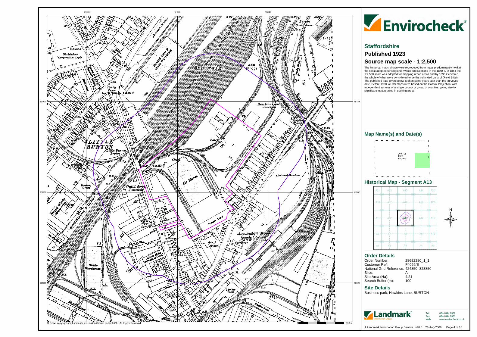
StaffordshirePublished 1923Source map scale - 1:2,500The historical maps shown were reproduced from maps predominantly held atthe scale adopted for England, Wales and Scotland in the 1840`s. In 1854 the1:2,500 scale was adopted for mapping urban areas and by 1896 it coveredthe whole of what were considered to be the cultivated parts of Great Britain.The published date given below is often some years later than the surveyeddate. Before 1938, all OS maps were based on the Cassini Projection, withindependent surveys of a single county or group of counties, giving rise tosignificant inaccuracies in outlying areas.
Historical Map - Segment A13
Map Name(s) and Date(s)

Order Details
Site DetailsBusiness park, Hawkins Lane, BURTON-
Order Number:Customer Ref:National Grid Reference:Slice:Site Area (Ha):Search Buffer (m):
28682280_1_1F4055/E424850, 323850A4.21100
Tel:Fax:Web:
0844 844 99520844 844 9951www.envirocheck.co.uk
Page 6 of 18A Landmark Information Group Service v40.0 21-Aug-2009
StaffordshirePublished 1937Source map scale - 1:2,500The historical maps shown were reproduced from maps predominantly held atthe scale adopted for England, Wales and Scotland in the 1840`s. In 1854 the1:2,500 scale was adopted for mapping urban areas and by 1896 it coveredthe whole of what were considered to be the cultivated parts of Great Britain.The published date given below is often some years later than the surveyeddate. Before 1938, all OS maps were based on the Cassini Projection, withindependent surveys of a single county or group of counties, giving rise tosignificant inaccuracies in outlying areas.
Historical Map - Segment A13
Map Name(s) and Date(s)
Order Details
Site DetailsBusiness park, Hawkins Lane, BURTON-
Order Number:Customer Ref:National Grid Reference:Slice:Site Area (Ha):Search Buffer (m):
28682280_1_1F4055/E424850, 323850A4.21100
Tel:Fax:Web:
0844 844 99520844 844 9951www.envirocheck.co.uk
Page 7 of 18A Landmark Information Group Service v40.0 21-Aug-2009
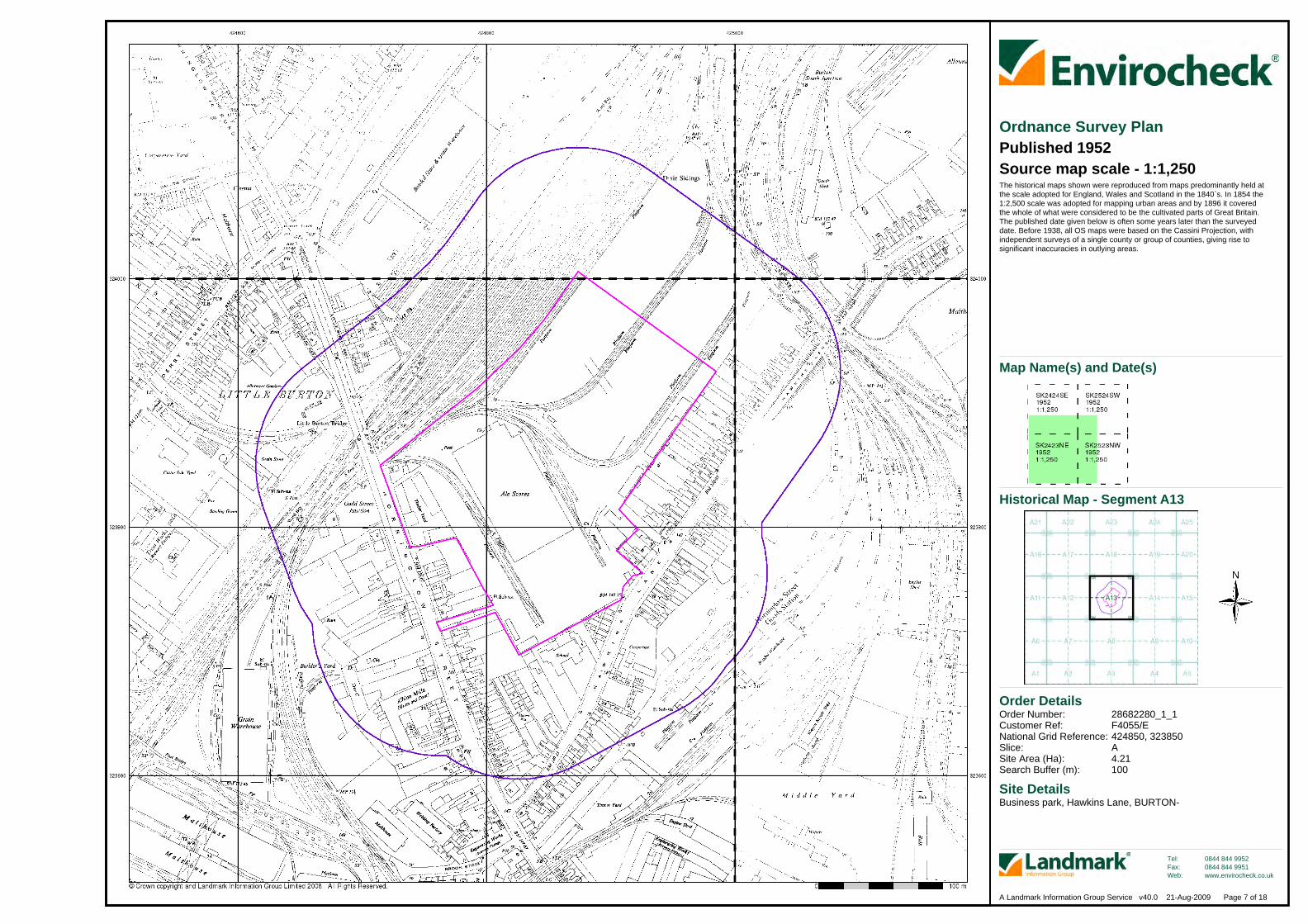
Ordnance Survey PlanPublished 1952Source map scale - 1:1,250The historical maps shown were reproduced from maps predominantly held atthe scale adopted for England, Wales and Scotland in the 1840`s. In 1854 the1:2,500 scale was adopted for mapping urban areas and by 1896 it coveredthe whole of what were considered to be the cultivated parts of Great Britain.The published date given below is often some years later than the surveyeddate. Before 1938, all OS maps were based on the Cassini Projection, withindependent surveys of a single county or group of counties, giving rise tosignificant inaccuracies in outlying areas.
Historical Map - Segment A13
Map Name(s) and Date(s)

Order Details
Site DetailsBusiness park, Hawkins Lane, BURTON-
Order Number:Customer Ref:National Grid Reference:Slice:Site Area (Ha):Search Buffer (m):
28682280_1_1F4055/E424850, 323850A4.21100
Tel:Fax:Web:
0844 844 99520844 844 9951www.envirocheck.co.uk
Page 8 of 18A Landmark Information Group Service v40.0 21-Aug-2009
Ordnance Survey PlanPublished 1953Source map scale - 1:2,500The historical maps shown were reproduced from maps predominantly held atthe scale adopted for England, Wales and Scotland in the 1840`s. In 1854 the1:2,500 scale was adopted for mapping urban areas and by 1896 it coveredthe whole of what were considered to be the cultivated parts of Great Britain.The published date given below is often some years later than the surveyeddate. Before 1938, all OS maps were based on the Cassini Projection, withindependent surveys of a single county or group of counties, giving rise tosignificant inaccuracies in outlying areas.
Historical Map - Segment A13
Map Name(s) and Date(s)

Order Details
Site DetailsBusiness park, Hawkins Lane, BURTON-
Order Number:Customer Ref:National Grid Reference:Slice:Site Area (Ha):Search Buffer (m):
28682280_1_1F4055/E424850, 323850A4.21100
Tel:Fax:Web:
0844 844 99520844 844 9951www.envirocheck.co.uk
Page 9 of 18A Landmark Information Group Service v40.0 21-Aug-2009
Ordnance Survey PlanPublished 1964 - 1971Source map scale - 1:1,250The historical maps shown were reproduced from maps predominantly held atthe scale adopted for England, Wales and Scotland in the 1840`s. In 1854 the1:2,500 scale was adopted for mapping urban areas and by 1896 it coveredthe whole of what were considered to be the cultivated parts of Great Britain.The published date given below is often some years later than the surveyeddate. Before 1938, all OS maps were based on the Cassini Projection, withindependent surveys of a single county or group of counties, giving rise tosignificant inaccuracies in outlying areas.
Historical Map - Segment A13
Map Name(s) and Date(s)
Order Details
Site DetailsBusiness park, Hawkins Lane, BURTON-
Order Number:Customer Ref:National Grid Reference:Slice:Site Area (Ha):Search Buffer (m):
28682280_1_1F4055/E424850, 323850A4.21100
Tel:Fax:Web:
0844 844 99520844 844 9951www.envirocheck.co.uk
Page 10 of 18A Landmark Information Group Service v40.0 21-Aug-2009
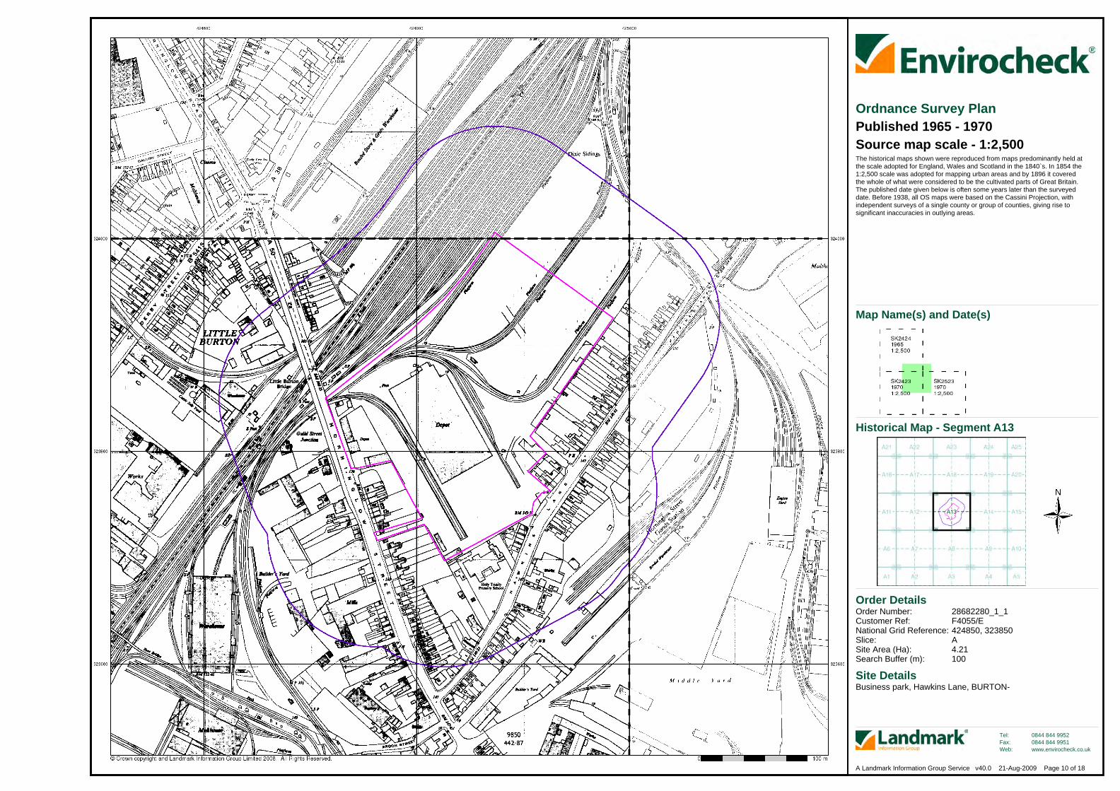
Ordnance Survey PlanPublished 1965 - 1970Source map scale - 1:2,500The historical maps shown were reproduced from maps predominantly held atthe scale adopted for England, Wales and Scotland in the 1840`s. In 1854 the1:2,500 scale was adopted for mapping urban areas and by 1896 it coveredthe whole of what were considered to be the cultivated parts of Great Britain.The published date given below is often some years later than the surveyeddate. Before 1938, all OS maps were based on the Cassini Projection, withindependent surveys of a single county or group of counties, giving rise tosignificant inaccuracies in outlying areas.
Historical Map - Segment A13
Map Name(s) and Date(s)

Order Details
Site DetailsBusiness park, Hawkins Lane, BURTON-
Order Number:Customer Ref:National Grid Reference:Slice:Site Area (Ha):Search Buffer (m):
28682280_1_1F4055/E424850, 323850A4.21100
Tel:Fax:Web:
0844 844 99520844 844 9951www.envirocheck.co.uk
Page 11 of 18A Landmark Information Group Service v40.0 21-Aug-2009
Additional SIMsPublished 1968 - 1988Source map scale - 1:1,250The SIM cards (Ordnance Survey's `Survey of Information on Microfilm') arefurther, minor editions of mapping which were produced and published inbetween the main editions as an area was updated. They date from 1947 to1994, and contain detailed information on buildings, roads and land-use. Thesemaps were produced at both 1:2,500 and 1:1,250 scales.
Historical Map - Segment A13
Map Name(s) and Date(s)
Order Details
Site DetailsBusiness park, Hawkins Lane, BURTON-
Order Number:Customer Ref:National Grid Reference:Slice:Site Area (Ha):Search Buffer (m):
28682280_1_1F4055/E424850, 323850A4.21100
Tel:Fax:Web:
0844 844 99520844 844 9951www.envirocheck.co.uk
Page 13 of 18A Landmark Information Group Service v40.0 21-Aug-2009
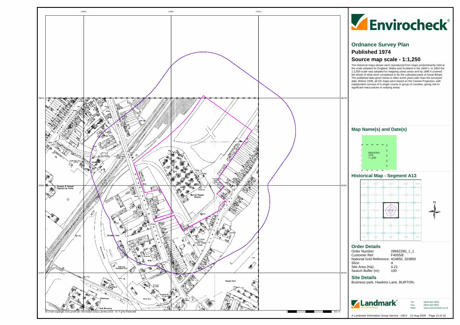
Ordnance Survey PlanPublished 1974Source map scale - 1:1,250The historical maps shown were reproduced from maps predominantly held atthe scale adopted for England, Wales and Scotland in the 1840`s. In 1854 the1:2,500 scale was adopted for mapping urban areas and by 1896 it coveredthe whole of what were considered to be the cultivated parts of Great Britain.The published date given below is often some years later than the surveyeddate. Before 1938, all OS maps were based on the Cassini Projection, withindependent surveys of a single county or group of counties, giving rise tosignificant inaccuracies in outlying areas.
Historical Map - Segment A13
Map Name(s) and Date(s)

Order Details
Site DetailsBusiness park, Hawkins Lane, BURTON-
Order Number:Customer Ref:National Grid Reference:Slice:Site Area (Ha):Search Buffer (m):
28682280_1_1F4055/E424850, 323850A4.21100
Tel:Fax:Web:
0844 844 99520844 844 9951www.envirocheck.co.uk
Page 17 of 18A Landmark Information Group Service v40.0 21-Aug-2009
Large-Scale National Grid DataPublished 1994Source map scale - 1:1,250'Large Scale National Grid Data' superseded SIM cards (Ordnance Survey's'Survey of Information on Microfilm') in 1992, and continued to be produceduntil 1999. These maps were the fore-runners of digital mapping and soprovide detailed information on houses and roads, but tend to show lesstopographic features such as vegetation. These maps were produced at both1:2,500 and 1:1,250 scales.
Historical Map - Segment A13
Map Name(s) and Date(s)