historic hurricane florence
TRANSCRIPT

C O N T E N T S
Hurricane Florence 1-5
Skywarn Recognition Day 6
Summer Volunteers 2018 7
July Rip Currents 8-9
Jim Merrell Retires 10-
20
http://weather.gov/Newport —> Bookmark it!!
National Weather Service, Newport/Morehead City, NC
Fall 2018 Edition
By Chris Collins, Meteorologist
Historic Hurricane Florence
Hurricane Florence was a long-lived Cape Verde hurricane and the wettest tropical cy-
clone on record in the Carolinas. The sixth named storm, third hurricane, and the
first major hurricane of the 2018 Atlantic hurricane season, Florence originated from a
strong tropical wave that emerged off the west coast of Africa on August 30, 2018. Flor-
ence became a tropical depression near Cape Verde on August 31 and progressed west-
northwest, becoming a Tropical Storm on September 1. Florence strengthened rapidly
on September 4–5, becoming a Category 4 storm on the Saffir-Simpson wind scale with
maximum sustained winds of 130 mph. Florence weakened to a tropical storm by Septem-
ber 7, but the system regained hurricane strength on September 9 and major hurricane sta-
tus with winds of 140 mph on September 10. However, increasing wind shear caused the
storm's winds to gradually weaken over the next few days. However, the storm's wind
field continued to grow. By the evening of September 13, Florence had been downgraded
to a Category 1 hurricane. Hurricane Florence made landfall near Wrightsville Beach early
on Saturday September 15, and weakened further as it slowly moved inland.
Florence produced extensive wind damage across eastern North Caro-
lina. Thousands of downed trees caused widespread power outages to
nearly all of eastern North Carolina. The historic legacy of Hurricane
Florence will be record breaking storm surge of 9 to 13 feet and dev-
astating rainfall of 20 to 30 inches, which produced catastrophic and
life-threatening flooding. The hardest hit areas included New Bern,
Newport, Belhaven, Oriental, North Topsail Beach and Jacksonville,
along with Downeast Carteret County. A storm total rainfall of
34.00 inches was reported in Swansboro, while the NWS office in
Newport recorded 25.20 inches. Wind gusts of 106 mph were reported
at Cape Lookout with 105 mph at Fort Macon.

2
Historic Hurricane Florence (Continued)

3
Historic Hurricane Florence (Continued)
Map of Rainfall Totals from Hurricane Florence (Courtesy Weather Prediction Center)

4
Historic Hurricane Florence (Continued)
Rainfall Flooding
Hydrograph from September 12, 2018 showing the predicted record crest for the Cape Fear River at Chinqapin.
Morehead City Pollocksville

5
Historic Hurricane Florence (Continued)
Storm Surge
Wind Damage
New Bern
North Topsail Beach
Morehead City Newport

6
Skywarn Recognition Day 2018
The 20th Annual Skywarn Recognition Day (SRD) Special Event will take place
from 7pm Friday, November 30th, to 7pm Saturday, December 1, 2018 here at Na-
tional Weather Service Newport.
Skywarn Recognition Day was developed in 1999 by the National Weather Service
(NWS) and the American Radio Relay League (ARRL). It celebrates the contribu-
tions that volunteer Skywarn amateur radio operators make to the NWS. On SRD,
Skywarn amateur radio operators visit NWS offices and contact other radio operators
across the nation and around the world. In the past, NWS offices have contacted all
50 states and more than 40 countries during the 24 hour event.
The NWS and the ARRL both recognize the importance that amateur radio provides
during severe weather. Many NWS offices acquire real time weather information
from amateur radio operators in the field. These operators, for example, may report
the position of a tornado, the height of flood waters, or damaging wind speeds during
hurricanes. All of this information is critical to the mission of the NWS which is to
preserve life and property. The special event celebrates this special contribution by
amateur radio operators.
Here at NWS Newport, in previous years for SRD, operators from ham radio clubs in
Carteret County, New Bern, Jacksonville, Oriental, Greenville and Kinston have par-
ticipated. Some even bring their own equipment and set up a “special event” station
and operate from our office! We typically operate on the 2 meter, 440 mHz, 20 me-
ter, 40 meter, and 80 meter bands as well as PSK 31. Our callsign is WX4MHX.
The amateur radio station here at NWS Newport has radios that operate on all these
frequencies (except PSK 31).
On any given day, we have a pool of radio operators we can call on to come to our
office and operate our radios to help gather reports during a weather event. They
have been a big help to us in gathering reports during severe thunderstorm outbreaks,
as well as “high impact” events like Hurricane Irene and the large tornado outbreak
in April 2011. We very much appreciate them giving of their time to help us and the
citizens here in central eastern North Carolina!
To learn more about SRD, go to http://hamradio.noaa.gov
By Hal Austin, Meteorologist

7
Student Volunteers 2018
By Casey Dail, Meteorologist
This summer our staff had the privilege of getting to know and working with two col-
lege students: Samantha Wright and Brandon Black.
Samm is a graduate student at East Carolina University. She worked on improving our
Skywarn Spotter program, by updating our database and utilizing her GIS skills. Her
work will help to improve our local program as well as severe weather verification
across Eastern North Carolina. Brandon is a graduate student at North Carolina State
University. He worked on a Total Water Level Verification study and also utilized GIS
to improve our flood impact statements at gauges across Eastern North Carolina.
Each volunteer’s research will be used to enhance the NOAA/NWS mission. In addition
to completing their individual research projects, each student spent many hours shadow-
ing the forecast staff in operations: from launching weather balloons to assisting with
forecast updates. They also participated in surveys and outreach events across Eastern
North Carolina.
Both Samm and Brandon have recently accepted positions in the National Weather Ser-
vice starting September 2018. We would like to thank Samm and Brandon for their hard
work this summer and we wish them all the best as they begin their careers with the Na-
tional Weather Service!
For additional information on or our volunteer program, please visit our webpage,
https://www.weather.gov/mhx/StudentInterns or contact [email protected]
Student Volunteers Samantha Wright and Brandon Black

8
July Was A Rippin’ Month
By Mack Simms, Meteorologist
July 2018 was a dangerous month for rip currents along the beaches of North Carolina.
Two distinct periods of high rip current risk occurred. The first, from July 7 to July 15,
was associated with swell from a meandering Hurricane Chris off the North Carolina
coast. The second, from July 22 to July 31, was associated with persistent unsettled
weather that was also responsible for extremely heavy rain in the Outer Banks. Beaches
from Cape Hatteras to Cape Lookout saw a high risk of rip currents for the majority of
the month.
A total of 114 rip current rescues were reported to the National Weather Service New-
port in July. The highest amount of rescues all occurred while Hurricane Chris was off-
shore, while conditions on the beaches were relatively calm. Nags Head beach reported
31 rescues on July 11 alone; Kitty Hawk Beach had 11. Additionally, there were 2 rip
current fatalities along the Outer Banks. In total, there were 7 surf zone fatalities in
North Carolina in July bringing the year-to-date total deaths to 13.

9
July Was A Rippin’ Month (Continued)
If you are caught in a rip current, do not swim directly to shore. Instead, swim parallel
to shore until you are outside the current’s influence, and then swim towards shore at an
angle away from the current. If you can’t make it to shore, relax and call or gesture for
help. If possible, only swim at guarded beaches. If you do choose to swim at an un-
guarded beach, never swim alone.

10
Reflections On The Last 20 Years at WFO MHX
By Jim Merrell, Meteorologist
Lead forecaster Jim Merrell retired from NWS Newport/Morehead City on August 31st
after 36 years of Federal service – 35 with the NWS. Jim was the lone member of the
staff that was a Carteret County native as he grew up near Beaufort and graduated from
East Carteret High School in 1978. After receiving his B.S. in Meteorology at NC State
in 1982, he entered the NWS at Jackson, KY in 1983 and slowly worked his way back
home starting in 1985 with a brief stint at the National Climatic Data Center in Ashe-
ville, followed by 13 years at the NWS Raleigh forecast office. Jim came to WFO New-
port/Morehead City in August 1998 as of one of the original 5 Lead Forecasters at the
office.
Here are Jim’s reflections on his past 20 years at the office:
“I have had the unique privilege of serving my home area doing a job that is interesting,
challenging and at times stressful, but all with the knowledge that people are depending
on our forecasts and warnings for the protection of life and property. One thing that
most folks may not think about too often is that sometimes the weather impacts the
forecasters as well, and I have had a few “up close and personal” events. Along that
line, here are my Top 6 events at MHX from the past 20 years.
Hurricane Bonnie – August 24-27 1998
“I had just started at MHX as a lead forecaster at beginning of month and my
family was staying in temporary quarters in Atlantic Beach condo. A Hurricane Warning
was issued on the morning of first day of school so what a way to kick it off for wife
and our 5 and 9 year-old sons. A Mandatory evacuation was ordered for Bogue Banks
so we had to go stay with family near Beaufort for rest of week.”
WATCH THIS YOUTUBE VIDEO FOR MORE ON JIM’S RETIREMENT!

11
Reflections On The Last 20 Years at WFO MHX (Continued)
Dennis and Floyd – August-September 1999
“We had 2 bouts of Dennis about 10 days apart with total rainfall near 11 inches
which flooded our yard. (Pics of boys trying to surf on ski). Floyd hit about 2 weeks lat-
er with wind and tornados near coast but the heaviest rainfall was inland over already
water-logged areas which resulted in devastating flooding.”
Hurricane Bonnie making landfall near Wilmington, NC late on August 26, 1998. (NWS NHC )

12
Reflections On The Last 20 Years at WFO MHX (Continued)
Flooding at Merrell home from Hurricane Dennis. (Merrell personal photos).

13
Reflections On The Last 20 Years at WFO MHX (Continued)
January 23, 2003 Coastal Snowstorm
“Many may not recall this one, but it was one of the most well-forecast events by
computer models I ever experienced. Both main models (NAM/GFS) indicated 6-12
inches of snow over coastal sections several days in advance which verified with 6-9
inches over Carteret County and 8-12 inches on Outer Banks. I have 2 distinct memo-
ries: 1) The Meteorologist-In-Charge shaking his head in disbelief when I did the morn-
ing briefing and stated that a Winter Storm Watch had been issued for 6-12 inches on
coast. 2) My brother (amateur forecaster) told me later that he still had doubts about my
forecast early in the morning of the event when there was no sign of precipitation on ra-
dar. He read my forecast discussion around that time that indicated forecast was on
track with snow expected to blossom over area in next 3-6 hours. He was quite im-
pressed when the forecast verified later that day.”

14
Reflections On The Last 20 Years at WFO MHX (Continued)
Storm total Snowfall January 23, 2003. (NWS MHX)
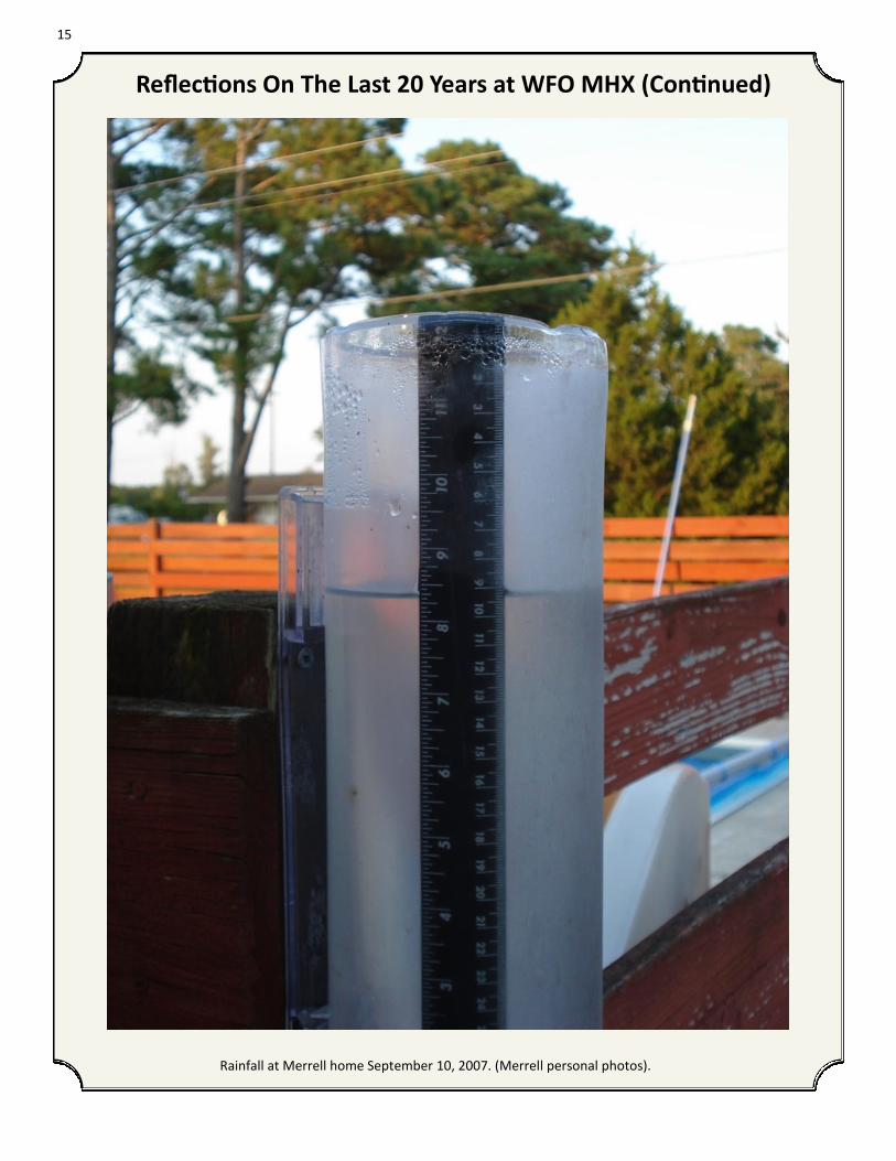
Tropical Storm Gabrielle—September 2007
“A fairly benign Tropical Storm except that training rain bands set up from Har-
lowe to Beaufort and produce 8.3 inches of rain at my house in 6 hours. This occurred
near high tide and produced flooding into our garage and storage building for the only
time in the 56 year history of residence.”
15
Reflections On The Last 20 Years at WFO MHX (Continued)
Rainfall at Merrell home September 10, 2007. (Merrell personal photos).

16
Reflections On The Last 20 Years at WFO MHX (Continued)
Rainfall Totals from Tropical Storm Gabrielle, September 8-10, 2007. (NWS MHX)
April 16 2011 Major Tornado outbreak
“I worked the day shift and told the forecasters and extra staff coming in for the
evening shift “if it’s rotating, put out a Tornado warning”. There was no doubt it was
going to be a bad day – never thought I would see multiple rotating supercells moving
across NC like in Tornado Alley.”

17
Reflections On The Last 20 Years at WFO MHX (Continued)
Radar velocity image showing strong rotational couplet (yellow circle) near Snow Hill around 545 PM April 16,
2011. An EF-3 tornado was on the ground at the time. (NWS MHX).
April 16 2011 Tornado Map. (NWS RAH).

18
Reflections On The Last 20 Years at WFO MHX (Continued)
Hit by a Tornado! - December 26 2012 –
“I worked the overnight shift and was sleeping during the day. A rotating storm
came in over Atlantic Beach and came up the Newport River and produced a small tor-
nado in my neighborhood along Highway 101 north of Beaufort. The outskirts of the
tornado knocked down one tree across our driveway and broke the tops out of 2 others.
Fortunately there was no damage to the house or vehicles. I will never forget being
awaken by roaring winds and my wife yelling to our sons to “Get in the hall””.
Damage at Merrell home (Merrell family photos).

19
Reflections On The Last 20 Years at WFO MHX (Continued)
Damage at Merrell home (Merrell family photos).

20
Reflections On The Last 20 Years at WFO MHX (Continued)
Bonus – a few others:
Sleet/Freezing rain events in 2015 – never thought I would see significant
accumulations at the coast.
Hurricane Matthew in October 2016 – had to miss NC State game against
Notre Dame – first home game not attended since 2003.
Record cold – 4 days below freezing. Longest stretch in eastern NC since
December 1917-January 1918 (not 1718 as somehow got reported).
I have been very blessed to work with some great people of the past 35 years , es-
pecially the past 20 in my home community near friends and family. I will miss
the day-to-day interaction with my colleagues, partners and customers, but do
look forward to not having to rotate between shifts on a weekly basis and to have
all weekends off. Here’s hoping your future holds more “High and dry” days than
“low and wet”.

21
530 Roberts Road
Newport, NC 28570
Phone: 252-223-5122
Fax: 252-223-3673
Website: http://weather.gov/Newport
Twitter: @NWSMoreheadCity
Facebook: /www.facebook.com/NWSMoreheadCity
National Weather Service
To report adverse weather conditions 24/7, please call us at: 1-800-889-6889