historic contexts of past disasters - unicaen · earthquake pakistan / india hurricanes ... atlas...
TRANSCRIPT

Materials provided for the Mountain-Risk Workshop„Risk Governance and Multi-Hazard Risk Assessment“Kempten, 15th – 22nd June 2008
Intensive Course – „Mountain risks and risk governance“
NOTIFICATION:The provided material is only and exclusively for your ownprivate use. Due to copyright, ANY distribution and consequent usage is STRICTLY prohibited.
Mou
ntai
nR
isks
: 200
7-20
10A
Mar
ie C
urie
Res
earc
h&
Tra
inin
g N
etw
ork
MOUNTAIN RISKS: Intensive Workshop Kempten, June 19th – 22nd, 2008
Risk Governance and Multi-Hazard Risk Assessment
Geomorphic Systems& Risk Reserach
IRPUDInstitute of Spatial Planning
HistoricHistoric contextscontexts of of pastpast disastersdisasters
Thomas Glade & Cees van WestenUniversity of Vienna & ITC
Mou
ntai
nR
isks
: 200
7-20
10A
Mar
ie C
urie
Res
earc
h&
Tra
inin
g N
etw
ork
MOUNTAIN RISKS: Intensive Workshop Kempten, June 19th – 22nd, 2008
Risk Governance and Multi-Hazard Risk Assessment
Geomorphic Systems& Risk Reserach
IRPUDInstitute of Spatial Planning
DisastersDisasters, , oneone afterafter thethe otherother ……
Earthquake Pakistan / IndiaHurricanes Central AmericaHurricane Katrina
Flooding Central Europe
Tsunami AsiaFlooding India
Cyclone Vietnam
Earthquake ChinaBurma……
Mou
ntai
nR
isks
: 200
7-20
10A
Mar
ie C
urie
Res
earc
h&
Tra
inin
g N
etw
ork
MOUNTAIN RISKS: Intensive Workshop Kempten, June 19th – 22nd, 2008
Risk Governance and Multi-Hazard Risk Assessment
Geomorphic Systems& Risk Reserach
IRPUDInstitute of Spatial Planning
DisastersDisasters, , oneone afterafter thethe otherother ……A serious disruption of the functioning of a community
or a society causing widespread human,
material, economic or environmental losses which
exceed the ability of the affected community or
society to cope using its own resources.
=> External help required Mou
ntai
nR
isks
: 200
7-20
10A
Mar
ie C
urie
Res
earc
h&
Tra
inin
g N
etw
ork
MOUNTAIN RISKS: Intensive Workshop Kempten, June 19th – 22nd, 2008
Risk Governance and Multi-Hazard Risk Assessment
Geomorphic Systems& Risk Reserach
IRPUDInstitute of Spatial Planning
DisastersDisasters areare spatialspatial featuresfeatures
Source:http://www.munichre.com/en/ts/geo_risks/natural_catastrophes_and_risks/world_map_of_natural_hazards/default.aspx
Mou
ntai
nR
isks
: 200
7-20
10A
Mar
ie C
urie
Res
earc
h&
Tra
inin
g N
etw
ork
MOUNTAIN RISKS: Intensive Workshop Kempten, June 19th – 22nd, 2008
Risk Governance and Multi-Hazard Risk Assessment
Geomorphic Systems& Risk Reserach
IRPUDInstitute of Spatial Planning
DisastersDisasters 2005 2005 (Munich RE)(Munich RE)

Materials provided for the Mountain-Risk Workshop„Risk Governance and Multi-Hazard Risk Assessment“Kempten, 15th – 22nd June 2008
Intensive Course – „Mountain risks and risk governance“
NOTIFICATION:The provided material is only and exclusively for your ownprivate use. Due to copyright, ANY distribution and consequent usage is STRICTLY prohibited.
Mou
ntai
nR
isks
: 200
7-20
10A
Mar
ie C
urie
Res
earc
h&
Tra
inin
g N
etw
ork
MOUNTAIN RISKS: Intensive Workshop Kempten, June 19th – 22nd, 2008
Risk Governance and Multi-Hazard Risk Assessment
Geomorphic Systems& Risk Reserach
IRPUDInstitute of Spatial Planning
DisastersDisasters 2006 2006 (Munich RE)(Munich RE)
Mou
ntai
nR
isks
: 200
7-20
10A
Mar
ie C
urie
Res
earc
h&
Tra
inin
g N
etw
ork
MOUNTAIN RISKS: Intensive Workshop Kempten, June 19th – 22nd, 2008
Risk Governance and Multi-Hazard Risk Assessment
Geomorphic Systems& Risk Reserach
IRPUDInstitute of Spatial Planning
DisastersDisasters & & developmentdevelopment
IsIs therethere a a relationrelation??
Mou
ntai
nR
isks
: 200
7-20
10A
Mar
ie C
urie
Res
earc
h&
Tra
inin
g N
etw
ork
MOUNTAIN RISKS: Intensive Workshop Kempten, June 19th – 22nd, 2008
Risk Governance and Multi-Hazard Risk Assessment
Geomorphic Systems& Risk Reserach
IRPUDInstitute of Spatial Planning
Relation Relation DevelopmentDevelopment / / LossesLossesM
ount
ain
Ris
ks: 2
007-
2010
A M
arie
Cur
ie R
esea
rch
& T
rain
ing
Net
wor
k
MOUNTAIN RISKS: Intensive Workshop Kempten, June 19th – 22nd, 2008
Risk Governance and Multi-Hazard Risk Assessment
Geomorphic Systems& Risk Reserach
IRPUDInstitute of Spatial Planning
DisastersDisasters cancan bebe ……
… at different magnitude:– When does a natural event becomes a disaster?
… at different scales– Individual-family-community-municipality…. World?
… fast or slow– Is desertification a disaster? Is water pollution a disaster?
… predictable or unexpected– Recent disasters in Netherlands: firework explosion, café
fire, airplane crash, animal diseases, flooding
Mou
ntai
nR
isks
: 200
7-20
10A
Mar
ie C
urie
Res
earc
h&
Tra
inin
g N
etw
ork
MOUNTAIN RISKS: Intensive Workshop Kempten, June 19th – 22nd, 2008
Risk Governance and Multi-Hazard Risk Assessment
Geomorphic Systems& Risk Reserach
IRPUDInstitute of Spatial Planning
DisasterDisaster typestypesHazards are purely natural
Hazards are purely man-made
Different spatial extend, magnitude, frequency, cause, impact
• Extraterrestrial – asteroid impact
• Internal Geo-dynamic processes– Earthquake, tsunami, volcanic eruption
• External geodynamic processes– Landslide, soil erosion, land degradation
• Hydrometeorological– Floods, Tropical storms, drought
• Ecological / environmental– Pollution, crop disease
• Epidemics– SARS, HIV / AIDS, Avian Flu
• Technological– (Industrial) accidents
• Conflicts– War, land mines, terrorism
Mou
ntai
nR
isks
: 200
7-20
10A
Mar
ie C
urie
Res
earc
h&
Tra
inin
g N
etw
ork
MOUNTAIN RISKS: Intensive Workshop Kempten, June 19th – 22nd, 2008
Risk Governance and Multi-Hazard Risk Assessment
Geomorphic Systems& Risk Reserach
IRPUDInstitute of Spatial Planning
DisasterDisaster typestypes
Only a small component of overall risks

Materials provided for the Mountain-Risk Workshop„Risk Governance and Multi-Hazard Risk Assessment“Kempten, 15th – 22nd June 2008
Intensive Course – „Mountain risks and risk governance“
NOTIFICATION:The provided material is only and exclusively for your ownprivate use. Due to copyright, ANY distribution and consequent usage is STRICTLY prohibited.
Mou
ntai
nR
isks
: 200
7-20
10A
Mar
ie C
urie
Res
earc
h&
Tra
inin
g N
etw
ork
MOUNTAIN RISKS: Intensive Workshop Kempten, June 19th – 22nd, 2008
Risk Governance and Multi-Hazard Risk Assessment
Geomorphic Systems& Risk Reserach
IRPUDInstitute of Spatial PlanningUNEP (2005): One planet many people: atlas of our changing environment- Nairobi, Kenya, Division of Early Warning and Assessment (DEWA).
Mou
ntai
nR
isks
: 200
7-20
10A
Mar
ie C
urie
Res
earc
h&
Tra
inin
g N
etw
ork
MOUNTAIN RISKS: Intensive Workshop Kempten, June 19th – 22nd, 2008
Risk Governance and Multi-Hazard Risk Assessment
Geomorphic Systems& Risk Reserach
IRPUDInstitute of Spatial Planning
Land use changeToskha Project, Egypt
UNEP (2005): One planet many people: Atlas of our changing environment.- Nairobi, Kenya, Division of Early Warning and Assessment (DEWA).
Aim: Doubling of the agricultural land area
Mou
ntai
nR
isks
: 200
7-20
10A
Mar
ie C
urie
Res
earc
h&
Tra
inin
g N
etw
ork
MOUNTAIN RISKS: Intensive Workshop Kempten, June 19th – 22nd, 2008
Risk Governance and Multi-Hazard Risk Assessment
Geomorphic Systems& Risk Reserach
IRPUDInstitute of Spatial Planning
Land use changeAl’ Isaw Iyah, Saudi Arabia
UNEP (2005): One planet many people: Atlas of our changing environment.- Nairobi, Kenya, Division of Early Warning and Assessment (DEWA).
Mou
ntai
nR
isks
: 200
7-20
10A
Mar
ie C
urie
Res
earc
h&
Tra
inin
g N
etw
ork
MOUNTAIN RISKS: Intensive Workshop Kempten, June 19th – 22nd, 2008
Risk Governance and Multi-Hazard Risk Assessment
Geomorphic Systems& Risk Reserach
IRPUDInstitute of Spatial Planning
HazardHazard variesvaries
• Spatially• Temporally• Frequency• Magnitude
Mou
ntai
nR
isks
: 200
7-20
10A
Mar
ie C
urie
Res
earc
h&
Tra
inin
g N
etw
ork
MOUNTAIN RISKS: Intensive Workshop Kempten, June 19th – 22nd, 2008
Risk Governance and Multi-Hazard Risk Assessment
Geomorphic Systems& Risk Reserach
IRPUDInstitute of Spatial Planning
TheThe‚‘‘officialofficial‘‘ disasterdisaster databasedatabase on on thethe WebWebwww.emdat.be

Materials provided for the Mountain-Risk Workshop„Risk Governance and Multi-Hazard Risk Assessment“Kempten, 15th – 22nd June 2008
Intensive Course – „Mountain risks and risk governance“
NOTIFICATION:The provided material is only and exclusively for your ownprivate use. Due to copyright, ANY distribution and consequent usage is STRICTLY prohibited.
Mou
ntai
nR
isks
: 200
7-20
10A
Mar
ie C
urie
Res
earc
h&
Tra
inin
g N
etw
ork
MOUNTAIN RISKS: Intensive Workshop Kempten, June 19th – 22nd, 2008
Risk Governance and Multi-Hazard Risk Assessment
Geomorphic Systems& Risk Reserach
IRPUDInstitute of Spatial Planning
EMDATEMDAT
At least one of the following criteria met for including in the EMDAT:
• 10 or more people reported killed• 100 or more people reported affected• Declaration of state of emergency• Call for international assistance
Mou
ntai
nR
isks
: 200
7-20
10A
Mar
ie C
urie
Res
earc
h&
Tra
inin
g N
etw
ork
MOUNTAIN RISKS: Intensive Workshop Kempten, June 19th – 22nd, 2008
Risk Governance and Multi-Hazard Risk Assessment
Geomorphic Systems& Risk Reserach
IRPUDInstitute of Spatial Planning
DisasterDisaster StatisticsStatisticsEvents have increased with a factor of 2 ! ?
Mou
ntai
nR
isks
: 200
7-20
10A
Mar
ie C
urie
Res
earc
h&
Tra
inin
g N
etw
ork
MOUNTAIN RISKS: Intensive Workshop Kempten, June 19th – 22nd, 2008
Risk Governance and Multi-Hazard Risk Assessment
Geomorphic Systems& Risk Reserach
IRPUDInstitute of Spatial Planning
DisasterDisaster StatisticsStatisticsLosses have increased with a factor of 7 !
Mou
ntai
nR
isks
: 200
7-20
10A
Mar
ie C
urie
Res
earc
h&
Tra
inin
g N
etw
ork
MOUNTAIN RISKS: Intensive Workshop Kempten, June 19th – 22nd, 2008
Risk Governance and Multi-Hazard Risk Assessment
Geomorphic Systems& Risk Reserach
IRPUDInstitute of Spatial Planning
Felgentreff C & Glade T (2008): Naturrisiken - Sozialkatastrophen: zum Geleit.- in: Felgentreff C. & Glade T (Hrsg.): Naturrisiken und Sozialkatastrophen.- Springer-Verlag. Berlin: 1-10.
Number of natural disasters
Economic losses
Insured losses
Mou
ntai
nR
isks
: 200
7-20
10A
Mar
ie C
urie
Res
earc
h&
Tra
inin
g N
etw
ork
MOUNTAIN RISKS: Intensive Workshop Kempten, June 19th – 22nd, 2008
Risk Governance and Multi-Hazard Risk Assessment
Geomorphic Systems& Risk Reserach
IRPUDInstitute of Spatial Planning
DisasterDisaster StatisticsStatisticsNumber of casualities
Number of people killed, injured or displaced due to natural hazards during the twentieth century (based on WHO, 2002).
Temporal evolution
Mou
ntai
nR
isks
: 200
7-20
10A
Mar
ie C
urie
Res
earc
h&
Tra
inin
g N
etw
ork
MOUNTAIN RISKS: Intensive Workshop Kempten, June 19th – 22nd, 2008
Risk Governance and Multi-Hazard Risk Assessment
Geomorphic Systems& Risk Reserach
IRPUDInstitute of Spatial Planning
WhyWhy such an such an increaseincrease??
Effect: - more extreme hazard events- higher vulnerability
Sea level rise:15 -58 cm / 100 yearTemperature increase:
1.8 to 4 degrees in 1 century

Materials provided for the Mountain-Risk Workshop„Risk Governance and Multi-Hazard Risk Assessment“Kempten, 15th – 22nd June 2008
Intensive Course – „Mountain risks and risk governance“
NOTIFICATION:The provided material is only and exclusively for your ownprivate use. Due to copyright, ANY distribution and consequent usage is STRICTLY prohibited.
Mou
ntai
nR
isks
: 200
7-20
10A
Mar
ie C
urie
Res
earc
h&
Tra
inin
g N
etw
ork
MOUNTAIN RISKS: Intensive Workshop Kempten, June 19th – 22nd, 2008
Risk Governance and Multi-Hazard Risk Assessment
Geomorphic Systems& Risk Reserach
IRPUDInstitute of Spatial Planning
WhyWhy such an such an increaseincrease??Population growth: 7-11 Billion
General-Anzeiger Bonn 26.10.02, S.43
So what?????
Mou
ntai
nR
isks
: 200
7-20
10A
Mar
ie C
urie
Res
earc
h&
Tra
inin
g N
etw
ork
MOUNTAIN RISKS: Intensive Workshop Kempten, June 19th – 22nd, 2008
Risk Governance and Multi-Hazard Risk Assessment
Geomorphic Systems& Risk Reserach
IRPUDInstitute of Spatial Planning
HistoricHistoric contextcontext!!!!Web Web searchsearch: Topics of : Topics of recordsrecords
Analysis of records, which are available online. Source: Lang, Dix 2007
Mou
ntai
nR
isks
: 200
7-20
10A
Mar
ie C
urie
Res
earc
h&
Tra
inin
g N
etw
ork
MOUNTAIN RISKS: Intensive Workshop Kempten, June 19th – 22nd, 2008
Risk Governance and Multi-Hazard Risk Assessment
Geomorphic Systems& Risk Reserach
IRPUDInstitute of Spatial Planning
Web Web searchsearch: Data : Data forfor recordsrecords
Time spans covered by records, which are available online.Source: Lang, Dix 2007
Mou
ntai
nR
isks
: 200
7-20
10A
Mar
ie C
urie
Res
earc
h&
Tra
inin
g N
etw
ork
MOUNTAIN RISKS: Intensive Workshop Kempten, June 19th – 22nd, 2008
Risk Governance and Multi-Hazard Risk Assessment
Geomorphic Systems& Risk Reserach
IRPUDInstitute of Spatial Planning
Glaser (2001)
FireFire
Mou
ntai
nR
isks
: 200
7-20
10A
Mar
ie C
urie
Res
earc
h&
Tra
inin
g N
etw
ork
MOUNTAIN RISKS: Intensive Workshop Kempten, June 19th – 22nd, 2008
Risk Governance and Multi-Hazard Risk Assessment
Geomorphic Systems& Risk Reserach
IRPUDInstitute of Spatial Planning
EarthquakeEarthquake
Picture annexed to "Relación sucinta de las desgracias, que han causado en Orihuela", Barcelona, 1829 (Albini et al. 2001).
Mou
ntai
nR
isks
: 200
7-20
10A
Mar
ie C
urie
Res
earc
h&
Tra
inin
g N
etw
ork
MOUNTAIN RISKS: Intensive Workshop Kempten, June 19th – 22nd, 2008
Risk Governance and Multi-Hazard Risk Assessment
Geomorphic Systems& Risk Reserach
IRPUDInstitute of Spatial Planning
f
h
g a c
be
d
Urban evolution of Nicolosi since 1359. 1) Old settlement nearby the monastery of S. Nicolò la Rena (until 1669); 2) Historical centre (building began around 1700); a) Piazza Quarter; b) Carmine Q.; c) S. Giuseppe Q.; d) Purgatorio Q.; e) Grazie Q.; f) Piano Q.; g) S. Francesco Q.; h) Tabor Q (Barbano et al. 2001)
Year Month Day Hour Epicentral area Lat Long Ms Ix Io Iobs (EMS)1408 11 9 Etna 37,750 15,000 3.0 5 5 5 1536 3 23 Etna 37,750 15,000 3.9 7-8 7-8 7-8 1633 2 21 23 00 Nicolosi 37,600 15,017 4.8 8-9 8-9 8-9 1669 3 10 23 25 Nicolosi 37,600 15,017 4.8 9 8-9 9 1693 1 11 13 30 Eastern Sicily 37,443 15,192 7.0 11 10-11 9-10 1818 2 20 18 15 Catania area 37,616 15,099 6.2 9-10 9 7-8 1832 11 24 03 30 Nicolosi 37,614 15,026 3.7 7-8 7 7-8 1842 11 18 01 15 Belpasso 37,607 15,022 3.4 5-6 6 5 1883 3 22 00 15 Nicolosi 37,653 15,065 4.1 7-8 8 7-8 1883 3 22 22 30 Belpasso 37,602 15,003 3.7 6-7 7 6-7 1883 3 26 21 26 Nicolosi 37,614 15,026 3.5 6-7 6-7 6-7 1883 4 5 08 58 Nicolosi 37,679 15,058 3.4 5-6 6 5-6 1883 4 28 01 25 Nicolosi 37,614 15,026 3.5 6-7 6-7 6-7 1883 6 24 07 47 E Flank Etna 37,705 15,121 3.7 6-7 7 4-5 1883 6 17 08 45 Nicolosi 37,614 15,024 2.8 4-5 4-5 4-5 1883 6 24 09 30 Nicolosi 37,615 15,023 2.8 4-5 4-5 4-5 1883 6 29 01 00 Nicolosi 37,613 15,028 2.8 4-5 4-5 4-5 1883 10 7 04 45 Nicolosi 37,613 15,027 2.8 4-5 4-5 4-5 1885 9 25 07 05 Nicolosi 37,614 15,027 3.7 7 7 7 1885 10 2 02 30 Nicolosi 37,614 15,026 3.5 6-7 6-7 6-7 1886 6 5 11 13 Santa Venerina 37,699 15,154 3.5 6 6-7 4-5 1892 7 8 18 50 S Flank Etna 37,673 14,997 3.7 6-7 7 4-5 1892 7 9 13 32 S Flank Etna 37,679 15,108 3.2 5 5-6 5 1893 3 31 Nicolosi 37,614 15,026 3.4 5-6 6 5-6 1893 4 1 07 09 Zafferana Etnea 37,685 15,056 3.4 5-6 6 4-5 1894 8 8 05 16 Mazzasette 37,653 15,110 4.3 8-9 8-9 4-5 1894 11 16 17 52 Bagnara Calabra 38,278 15,903 5.9 9 8-9 5
Site catalogue for Nicolosi (I > 4-5 EMS). Source parameters fromCamassi and Stucchi (1997) and Antichi et al. (2000). Coordinatesrepresent the macroseismic epicentre determined as the barycentre of thedata points with intensity I=Ix, Ix-1. Ms, surface wave magnitude, frominstrumental observation or derived from epicentral intensity I0 byexperimental relationships (Camassi and Stucchi, 1997; Azzaro and Barbano, 1997). Ix, maximum observed intensity; I0, epicentral intensity; Iobs, observed intensity in Nicolosi (Barbano et al. 2001).
Mt. Mt. EtnaEtna, , NicolosiNicolosi

Materials provided for the Mountain-Risk Workshop„Risk Governance and Multi-Hazard Risk Assessment“Kempten, 15th – 22nd June 2008
Intensive Course – „Mountain risks and risk governance“
NOTIFICATION:The provided material is only and exclusively for your ownprivate use. Due to copyright, ANY distribution and consequent usage is STRICTLY prohibited.
Mou
ntai
nR
isks
: 200
7-20
10A
Mar
ie C
urie
Res
earc
h&
Tra
inin
g N
etw
ork
MOUNTAIN RISKS: Intensive Workshop Kempten, June 19th – 22nd, 2008
Risk Governance and Multi-Hazard Risk Assessment
Geomorphic Systems& Risk Reserach
IRPUDInstitute of Spatial Planning
ReconstructionReconstruction of of seismicityseismicity
Seismic history of Nicolosi. Observedintensities Iobs (Barbano et al. 2001)
1
10
100
1000
I n t e n s i t y ( E M S - 9 8 )3 4 5 6 7 8 9 10
Ret
urn
perio
d(y
r)
Average return period with associated error forNicolosi site, computed according to Magri et al. (1994) (Barbano et al. 2001).
Mou
ntai
nR
isks
: 200
7-20
10A
Mar
ie C
urie
Res
earc
h&
Tra
inin
g N
etw
ork
MOUNTAIN RISKS: Intensive Workshop Kempten, June 19th – 22nd, 2008
Risk Governance and Multi-Hazard Risk Assessment
Geomorphic Systems& Risk Reserach
IRPUDInstitute of Spatial Planning
EarthquakeEarthquake
Localities (in northern Italy) affected by the 1117 earthquake, based on historical sources and epigraphs (Galadini et al. 2001).
Localities with archaeological remains whichtestify to possible seismically induced damagerelated to the 1117 earthquake (Galadini et al. 2001).
Mou
ntai
nR
isks
: 200
7-20
10A
Mar
ie C
urie
Res
earc
h&
Tra
inin
g N
etw
ork
MOUNTAIN RISKS: Intensive Workshop Kempten, June 19th – 22nd, 2008
Risk Governance and Multi-Hazard Risk Assessment
Geomorphic Systems& Risk Reserach
IRPUDInstitute of Spatial Planning
A, B) Walls of the left nave and apse of the ancient San Lorenzo church at Trento; the destruction of the church, together with the tilting and fracturing of the walls are the probable effects of the 1117 earthquake; C) chronological constraints available for the San Lorenzo church destruction from archaeological, historical and radiocarbon dating (Galadini et al. 2001).
Summary map of the available data derived from historicalsources, architectural evolution of Romanic buildings,
archaeology and historical landslides; indications of coseismic damage and geological effects are more denselydistributed in the area indicated by thin blue lines (Galadini
et al. 2001).
Mou
ntai
nR
isks
: 200
7-20
10A
Mar
ie C
urie
Res
earc
h&
Tra
inin
g N
etw
ork
MOUNTAIN RISKS: Intensive Workshop Kempten, June 19th – 22nd, 2008
Risk Governance and Multi-Hazard Risk Assessment
Geomorphic Systems& Risk Reserach
IRPUDInstitute of Spatial Planning
DateTime HST
Lat deg
Lat min
Lon deg
Lon min region
Pref. Depth
M other
M other source
M pref
M pref source I (max) Location/felt report Comment
11/01/1790 kilauea 6,4 int VII-VIII
The natives say that in the days of Kamehameha, 80 shocks were felt in one
day, some of them so hard as to throw down houses. This was soon followed by
an eruption of the volcano which destroyed some lives and did much
damage. . . .Martin, 1979, p. 71; minimum magnitude
of largest event estimated from intensity
8/31/1821 19:00west
hawaii 5,3 int V . . . at 7 pm we had a very smart shock of
an earth quake. . . . [p. 8]
Young, 1801 [Note: Young was living in west Hawaii; journal page labeled 1821, but day/date do not agree with perpetual calendar. If day is accepted, then date is
Aug. 31, 1821.]; intensity interpreted from "smart" as used in Lyman diary
6/01/1823 22:00 kl sf ~7 W&K 7,0 w&k IX (S&C)
Graben on Kilauea's lower SW rift formed two months before Ellis visit on July 31;
felt at Kaimu (Puna) where it formed a crack one foot wide; seawater entered a
freshwater well; stone wall, 4 ft thick, 6 ft high, thrown down; no mention of
tsunamiWyss and Koyanagi, 1992, App. 3, p. 57;
Ellis/1825; Stover and Coffmann, 1993
7/10/1823
Eruption on Kilauea's southwest rift zone (Great Crack) described as occurring three
weeks before Ellis' visit. [Note: this possibly dates the end of the eruption. The
beginning might have been close to the time of the large earthquake] Ellis, 1825
1/6/1825 23:30 kona? 6,2 int VII
a heavy shock at Kaawaloa, preceded by rumbling; motion so rapid that it woke us
from sleep and shook us violently; standing persons thrown suddenly to the
earth, lying persons tossed from side to side; acc by landslides from Kealakekua
paliEly, 1825, p. 686-687; stationed at
Kaawaloa, now Kealakekua Bay
1/7/1825 02:00 kona? 4,5 int IV-V
At the hours of 2 and 3 the same night two others were experienced much lighter than the one before described. The vibrations of
the earth were from the North east to the south west terminating suddenly like the
motion of a carriage slipping on a pavement
Ely, 1825, p. 686-687; aftershocks? Intensity assumed strong enough to waken
people1/7/1825 03:00 kona? 4,5 int IV-V do do
9/6/1825 11:59 maui? 5,9 int VI
. . . there was a shock of an earthquake perceived here [Lahaina, Maui] which
though not considerable was nonetheless sufficient to alarm the people . . . Not reported elsewhere on Maui. [no time
given]Richards, 1825; stationed at Lahaina,
Maui
1/9/1826 06:00south
hawaii? 5,3 int V
. . . a little before sunrise, we had a considerable smart shock of an
earthquake. I first perceived by the trembling or shaking of things in the
house and was soon followed by a shock that made crockery rattle considerable.
The whole duration was perhap Goodrich, 1826; stationed at Hilo, Hawaii
11/5/1827 01:59 hawaii 5,3 int V
Last night we were awakened from our quiet slumbers by the shock of an
earthquake. It was much lighter than what is often expressed in this island though it
shook our house very sensibly [time assumed] Ely, 1825, p. 686
. . . at 7 pm we had a very smart shock of an earth quake. . . . [p. 8]
Young, 1801 [Note: Young was living in west Hawaii; journal page labeled 1821, but day/date do not agree with perpetual calendar. If day is accepted, then date is
Aug. 31, 1821.]; intensity interpreted from "smart" as used in Lyman diary
Klein FW & Wright TL (2000): Cataloge of Hawaiianearthquakes, 1823-1959, USGS Professional Paper 1623
EarthquakeEarthquake--CataloqueCataloque of Hawaii,of Hawaii,1823 1823 -- 19591959
Mou
ntai
nR
isks
: 200
7-20
10A
Mar
ie C
urie
Res
earc
h&
Tra
inin
g N
etw
ork
MOUNTAIN RISKS: Intensive Workshop Kempten, June 19th – 22nd, 2008
Risk Governance and Multi-Hazard Risk Assessment
Geomorphic Systems& Risk Reserach
IRPUDInstitute of Spatial Planning
ClimateClimate and and weatherweather recordsrecords
Glaser (2001)
Mou
ntai
nR
isks
: 200
7-20
10A
Mar
ie C
urie
Res
earc
h&
Tra
inin
g N
etw
ork
MOUNTAIN RISKS: Intensive Workshop Kempten, June 19th – 22nd, 2008
Risk Governance and Multi-Hazard Risk Assessment
Geomorphic Systems& Risk Reserach
IRPUDInstitute of Spatial Planning
LakeLake--level changeslevel changes
Frauenchiemsee
Pfister (1999)
Bodensee

Materials provided for the Mountain-Risk Workshop„Risk Governance and Multi-Hazard Risk Assessment“Kempten, 15th – 22nd June 2008
Intensive Course – „Mountain risks and risk governance“
NOTIFICATION:The provided material is only and exclusively for your ownprivate use. Due to copyright, ANY distribution and consequent usage is STRICTLY prohibited.
Mou
ntai
nR
isks
: 200
7-20
10A
Mar
ie C
urie
Res
earc
h&
Tra
inin
g N
etw
ork
MOUNTAIN RISKS: Intensive Workshop Kempten, June 19th – 22nd, 2008
Risk Governance and Multi-Hazard Risk Assessment
Geomorphic Systems& Risk Reserach
IRPUDInstitute of Spatial Planning
FloodsFloods
Poliwoda G (2007): Aus Katastrophen Lernen - Sachsen im Kampf gegen die Fluten der Elbe 1784 bis1845.- Böhlau Verlag, Köln, S.17
Mou
ntai
nR
isks
: 200
7-20
10A
Mar
ie C
urie
Res
earc
h&
Tra
inin
g N
etw
ork
MOUNTAIN RISKS: Intensive Workshop Kempten, June 19th – 22nd, 2008
Risk Governance and Multi-Hazard Risk Assessment
Geomorphic Systems& Risk Reserach
IRPUDInstitute of Spatial Planning
FloodsFloods
Glaser (2001)
Glaser (2001)
Glaser (2001)
Mou
ntai
nR
isks
: 200
7-20
10A
Mar
ie C
urie
Res
earc
h&
Tra
inin
g N
etw
ork
MOUNTAIN RISKS: Intensive Workshop Kempten, June 19th – 22nd, 2008
Risk Governance and Multi-Hazard Risk Assessment
Geomorphic Systems& Risk Reserach
IRPUDInstitute of Spatial Planning
FloodsFloods
Different views of the Pont Major Church (Girona) illustrating the level of the November 3rd 1617 flood event of the Ter River. Arrows indicate the flood elevation which isapproximately 3.6 m above street level. (Benito et al. in press).
3.6 m
Mou
ntai
nR
isks
: 200
7-20
10A
Mar
ie C
urie
Res
earc
h&
Tra
inin
g N
etw
ork
MOUNTAIN RISKS: Intensive Workshop Kempten, June 19th – 22nd, 2008
Risk Governance and Multi-Hazard Risk Assessment
Geomorphic Systems& Risk Reserach
IRPUDInstitute of Spatial Planning
FloodsFloods
Glaser (2001)
Flood marksFlood marksOld bridge Old bridge -- HeidelbergHeidelberg
Mou
ntai
nR
isks
: 200
7-20
10A
Mar
ie C
urie
Res
earc
h&
Tra
inin
g N
etw
ork
MOUNTAIN RISKS: Intensive Workshop Kempten, June 19th – 22nd, 2008
Risk Governance and Multi-Hazard Risk Assessment
Geomorphic Systems& Risk Reserach
IRPUDInstitute of Spatial Planning
FloodsFloods
Poliwoda G (2007): Aus KatastrophenLernen - Sachsen im Kampf gegen die Flutender Elbe 1784 bis1845.- Böhlau Verlag, Köln,S.201
Mou
ntai
nR
isks
: 200
7-20
10A
Mar
ie C
urie
Res
earc
h&
Tra
inin
g N
etw
ork
MOUNTAIN RISKS: Intensive Workshop Kempten, June 19th – 22nd, 2008
Risk Governance and Multi-Hazard Risk Assessment
Geomorphic Systems& Risk Reserach
IRPUDInstitute of Spatial Planning
ReconstructionsReconstructions
Poliwoda G (2007): Aus KatastrophenLernen - Sachsen im Kampf gegen die Fluten der Elbe 1784 bis1845.- BöhlauVerlag, Köln, S.213

Materials provided for the Mountain-Risk Workshop„Risk Governance and Multi-Hazard Risk Assessment“Kempten, 15th – 22nd June 2008
Intensive Course – „Mountain risks and risk governance“
NOTIFICATION:The provided material is only and exclusively for your ownprivate use. Due to copyright, ANY distribution and consequent usage is STRICTLY prohibited.
Mou
ntai
nR
isks
: 200
7-20
10A
Mar
ie C
urie
Res
earc
h&
Tra
inin
g N
etw
ork
MOUNTAIN RISKS: Intensive Workshop Kempten, June 19th – 22nd, 2008
Risk Governance and Multi-Hazard Risk Assessment
Geomorphic Systems& Risk Reserach
IRPUDInstitute of Spatial Planning
(Glaser, 2001)
Areas of damages from flooding1784, ElbeVally between Prague and Magdeburg
Mou
ntai
nR
isks
: 200
7-20
10A
Mar
ie C
urie
Res
earc
h&
Tra
inin
g N
etw
ork
MOUNTAIN RISKS: Intensive Workshop Kempten, June 19th – 22nd, 2008
Risk Governance and Multi-Hazard Risk Assessment
Geomorphic Systems& Risk Reserach
IRPUDInstitute of Spatial Planning
Ordinary Flood No documentary record
Extraordinary Flood Documentary record
Catastrophic Flood Documentary record
Normal Level No documentary recorda)
d)
c)
b)
Graphic representation of the flood definition criteria (Llasat & Barriendos 2001).
Mou
ntai
nR
isks
: 200
7-20
10A
Mar
ie C
urie
Res
earc
h&
Tra
inin
g N
etw
ork
MOUNTAIN RISKS: Intensive Workshop Kempten, June 19th – 22nd, 2008
Risk Governance and Multi-Hazard Risk Assessment
Geomorphic Systems& Risk Reserach
IRPUDInstitute of Spatial Planning
M i
ñ o
S e g u r a
D u e r o
J ú c a r
T u r i a
E b r o
G u a d i a n a
T a j o
G u a d a l q u i v i r5354
49
5256
4248
51
55
118
20 17
40
10
2
1
384346
15
45
21
4
5
12
19
16
13
14
35
3326
22
6
3
Data collection from documentary sources
Localities to be researchedData collection from bibliographical sources
0km 500km
7
9
18
2524
2327
343231302928
36
374139
44
47
50
Data collection from other researchers
Localities already studied and with potential flood series (Llasat & Barriendos 2001).
Mou
ntai
nR
isks
: 200
7-20
10A
Mar
ie C
urie
Res
earc
h&
Tra
inin
g N
etw
ork
MOUNTAIN RISKS: Intensive Workshop Kempten, June 19th – 22nd, 2008
Risk Governance and Multi-Hazard Risk Assessment
Geomorphic Systems& Risk Reserach
IRPUDInstitute of Spatial Planning
A: Schematic diagram illustrating the changing level of floodperception through time according to progressive human settlementtowards the river. This means that the threshold of flood discharges
recorded in the historical documents decreases with time. B: Geomorphic surfaces covered with slack-water flood deposits
showing different thresholds of flood discharges. C: Organisation of historical, palaeoflood and systematic data, using the described
scharge thresholds, for flood frequency analysis (Benito et al. 2004).
Alcove filled with slack-water flood deposits of the Llobregat river. Numbers indicate distinct flood units or flood events (Benito et al. 2004).
Mou
ntai
nR
isks
: 200
7-20
10A
Mar
ie C
urie
Res
earc
h&
Tra
inin
g N
etw
ork
MOUNTAIN RISKS: Intensive Workshop Kempten, June 19th – 22nd, 2008
Risk Governance and Multi-Hazard Risk Assessment
Geomorphic Systems& Risk Reserach
IRPUDInstitute of Spatial Planning
Morphological changes of the River Tagus during the last two centuries, in the Santarém region (Azevedo et al. 2004). M
ount
ain
Ris
ks: 2
007-
2010
A M
arie
Cur
ie R
esea
rch
& T
rain
ing
Net
wor
k
MOUNTAIN RISKS: Intensive Workshop Kempten, June 19th – 22nd, 2008
Risk Governance and Multi-Hazard Risk Assessment
Geomorphic Systems& Risk Reserach
IRPUDInstitute of Spatial Planning
AM / PD
Censored Data -Magnitude
known or not
Censored Data -Magnitude
known or not
PERIODS(a)
PREHISTORIC(b)
HISTORIC
Datasources
Data types
PaleofloodHydrology
(b1) OccasionalObservations
(b2) PermanentObservers
Gauging Stations
Systematic Data
Wat
er E
leva
tion
/D
isch
arge
Uncertainties
PerceptionThreshold
AlarmThresholds
12
(c)CONTEMPORARY
1 Year
SamplingThreshold
Daily WaterLevels–Detail
of Floods
ORAL EVIDENCEARCHIVAL SURVEY
GEOLOGICAL INDICATORSBIOLOGICAL INDICATORS
AM SeriesPD Series
Various types of flood information (Naulet et al. 2001).
Cross section at the natural arc of Pont d’Arc(near Vallon Pont d’Arc) with water levels of the October 9-10, 1827 and September 28-29, 1846 floods (Combier, 1857) (aus Naulet et al. 2001).
10 oct. 1827
9 sept. 1772
3 sept. 1744
6
10
14
18
h w
ater
ele
vatio
n (m
)
HISTORIC PERIODOccasional observations
Provisional water level series reconstituted at the hydrometricstation of Vallon Pont d'Arc over the period 1744-1965 (aus Naulet et al. 2001).
FloodsFloods

Materials provided for the Mountain-Risk Workshop„Risk Governance and Multi-Hazard Risk Assessment“Kempten, 15th – 22nd June 2008
Intensive Course – „Mountain risks and risk governance“
NOTIFICATION:The provided material is only and exclusively for your ownprivate use. Due to copyright, ANY distribution and consequent usage is STRICTLY prohibited.
Mou
ntai
nR
isks
: 200
7-20
10A
Mar
ie C
urie
Res
earc
h&
Tra
inin
g N
etw
ork
MOUNTAIN RISKS: Intensive Workshop Kempten, June 19th – 22nd, 2008
Risk Governance and Multi-Hazard Risk Assessment
Geomorphic Systems& Risk Reserach
IRPUDInstitute of Spatial Planning
Earth flows(Gisborne, April 2002)
Dikau, R., Brunsden, D., Schrott, L. & Ibsen, M. [eds.] 1996: Landslide Recognition. Identification, movement and causes.- Chichester, Wiley.
Dikau, R. & Glade, T. 2002: Gefahren und Risiken durch Massenbewegungen.- Geographische Rundschau, 54(1): 38-45.
Mass movementsMass movements
ca. 150 m
Mou
ntai
nR
isks
: 200
7-20
10A
Mar
ie C
urie
Res
earc
h&
Tra
inin
g N
etw
ork
MOUNTAIN RISKS: Intensive Workshop Kempten, June 19th – 22nd, 2008
Risk Governance and Multi-Hazard Risk Assessment
Geomorphic Systems& Risk Reserach
IRPUDInstitute of Spatial Planning
Rockslide ofRockslide ofPiursPiurs, Italy, Italy25. August /25. August /4. September 16184. September 1618
whole flank collapsed – approx. 3 Mio m3
Deposits up to 10m in thicknessProlonged rainfall end of August200 houses in Piurs & Schilanoburied930 fatalities
Zeller R (2003): Wahrnehmung und Deutung von Naturkatastrophen.- In: Pfister
C (Hrsg.): Am Tag danach.- Haupt Verlag, 55-68.
Mou
ntai
nR
isks
: 200
7-20
10A
Mar
ie C
urie
Res
earc
h&
Tra
inin
g N
etw
ork
MOUNTAIN RISKS: Intensive Workshop Kempten, June 19th – 22nd, 2008
Risk Governance and Multi-Hazard Risk Assessment
Geomorphic Systems& Risk Reserach
IRPUDInstitute of Spatial Planning
past small-scale landslides destabilsed mountain flank,2 extreme wet years prior to 1806,Landslide body went as far as 100m upwards on opposite slope,Part of body in Lake Lauerzer, off-site damages at lake shores
Umrissradierung gestochen v. Gabriel Lory
Villages Goldau, Röthen & Buosigen were buried>500 fatalities, 200 homelesslosses ~200 million CHF
Fässler A (2003): Geburt der gesamtheitlichen Solidarität.- In: Pfister C (Hrsg.): Am Tag danach.- Haupt Verlag, 55-68.
Rockslide of Rockslide of ArthArth GoldauGoldau 2. September 18062. September 1806M
ount
ain
Ris
ks: 2
007-
2010
A M
arie
Cur
ie R
esea
rch
& T
rain
ing
Net
wor
k
MOUNTAIN RISKS: Intensive Workshop Kempten, June 19th – 22nd, 2008
Risk Governance and Multi-Hazard Risk Assessment
Geomorphic Systems& Risk Reserach
IRPUDInstitute of Spatial Planning
Mou
ntai
nR
isks
: 200
7-20
10A
Mar
ie C
urie
Res
earc
h&
Tra
inin
g N
etw
ork
MOUNTAIN RISKS: Intensive Workshop Kempten, June 19th – 22nd, 2008
Risk Governance and Multi-Hazard Risk Assessment
Geomorphic Systems& Risk Reserach
IRPUDInstitute of Spatial Planning
10 million m3 rock, area 9 mill. m2, 3 surges in 20 min.people spectated event
- despite knowledge of rockfalls 114 fatalitiespreparatory factor: shale mining
Bläuer HP (2003): Der Bergsturz von Elm am 11. September 1881.- In: Pfister C (Hrsg.): Am Tag danach.-Haupt Verlag, 113-130.
Lithographie v. Heinrich Burger-Hofer
Rockslide of Elm Rockslide of Elm 11. September 188111. September 1881
Mou
ntai
nR
isks
: 200
7-20
10A
Mar
ie C
urie
Res
earc
h&
Tra
inin
g N
etw
ork
MOUNTAIN RISKS: Intensive Workshop Kempten, June 19th – 22nd, 2008
Risk Governance and Multi-Hazard Risk Assessment
Geomorphic Systems& Risk Reserach
IRPUDInstitute of Spatial Planning
deposition area
Clearing with simple tools(pickax, shovel, tackle,
wheelbarrow) took several decades
today: meadows and sport facilities
Photographs: J. Ganz
RockslideRockslideof Elmof Elm
Materials provided for the Mountain-Risk Workshop„Risk Governance and Multi-Hazard Risk Assessment“Kempten, 15th – 22nd June 2008
Intensive Course – „Mountain risks and risk governance“
NOTIFICATION:The provided material is only and exclusively for your ownprivate use. Due to copyright, ANY distribution and consequent usage is STRICTLY prohibited.
Mou
ntai
nR
isks
: 200
7-20
10A
Mar
ie C
urie
Res
earc
h&
Tra
inin
g N
etw
ork
MOUNTAIN RISKS: Intensive Workshop Kempten, June 19th – 22nd, 2008
Risk Governance and Multi-Hazard Risk Assessment
Geomorphic Systems& Risk Reserach
IRPUDInstitute of Spatial Planning
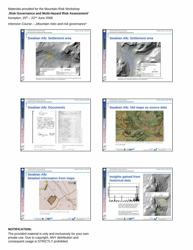
Bell R (2007): Lokale und regionale Gefahren- und Risikoanalyse gravitativer Massenbewegungen an der Schwäbischen Alb.- Doktorarbeit eingereicht an der Universität Bonn.
SwabianSwabian Alb: Settlement areaAlb: Settlement area
Mou
ntai
nR
isks
: 200
7-20
10A
Mar
ie C
urie
Res
earc
h&
Tra
inin
g N
etw
ork
MOUNTAIN RISKS: Intensive Workshop Kempten, June 19th – 22nd, 2008
Risk Governance and Multi-Hazard Risk Assessment
Geomorphic Systems& Risk Reserach
IRPUDInstitute of Spatial Planning
SwabianSwabian Alb: DocumentsAlb: Documents
Account of landslide in Hausen an der Fils 1805Source: Gemeindearchiv Bad Überkingen
Account of landslide in Ratshausen 1787Source: HStA Stuttgart
By
cout
esy
of A
. Dix
, Uni
vers
ity o
f Bam
berg
.
Mou
ntai
nR
isks
: 200
7-20
10A
Mar
ie C
urie
Res
earc
h&
Tra
inin
g N
etw
ork
MOUNTAIN RISKS: Intensive Workshop Kempten, June 19th – 22nd, 2008
Risk Governance and Multi-Hazard Risk Assessment
Geomorphic Systems& Risk Reserach
IRPUDInstitute of Spatial Planning
SwabianSwabian Alb: Old maps as source dataAlb: Old maps as source data
Extract of so-called Bachmayer-Karte from 1651, landslide at the NägelesbergSource: HStA Stuttgart
By
cout
esy
of A
. Dix
, Uni
vers
ity o
f Bam
berg
.
Mou
ntai
nR
isks
: 200
7-20
10A
Mar
ie C
urie
Res
earc
h&
Tra
inin
g N
etw
ork
MOUNTAIN RISKS: Intensive Workshop Kempten, June 19th – 22nd, 2008
Risk Governance and Multi-Hazard Risk Assessment
Geomorphic Systems& Risk Reserach
IRPUDInstitute of Spatial Planning
SwabianSwabian Alb:Alb:Detailed information from mapsDetailed information from maps
Detail from a map of the Kirchheimer Forst, 1816Source: HStA Stuttgart
Zur V
erfü
gung
ges
tellt
dur
ch A
. Dix
, Uni
vers
ität B
ambe
rg.
Mou
ntai
nR
isks
: 200
7-20
10A
Mar
ie C
urie
Res
earc
h&
Tra
inin
g N
etw
ork
MOUNTAIN RISKS: Intensive Workshop Kempten, June 19th – 22nd, 2008
Risk Governance and Multi-Hazard Risk Assessment
Geomorphic Systems& Risk Reserach
IRPUDInstitute of Spatial Planning
Insights gained from Insights gained from historical datahistorical data
Landslide at the Gräbelesberg (top = hillshade of the DTM1 with mapped landslide body out of GK25, bottom = hillshade with mapped massmovements and historic protective barrier)
Bell, R. (2007): Lokale und regionale Gefahren-und Risikoanalyse gravitativerMassenbewegungen an der Schwäbischen Alb.-Doktorarbeit eingereicht an der Universität Bonn.

Materials provided for the Mountain-Risk Workshop„Risk Governance and Multi-Hazard Risk Assessment“Kempten, 15th – 22nd June 2008
Intensive Course – „Mountain risks and risk governance“
NOTIFICATION:The provided material is only and exclusively for your ownprivate use. Due to copyright, ANY distribution and consequent usage is STRICTLY prohibited.
Mou
ntai
nR
isks
: 200
7-20
10A
Mar
ie C
urie
Res
earc
h&
Tra
inin
g N
etw
ork
MOUNTAIN RISKS: Intensive Workshop Kempten, June 19th – 22nd, 2008
Risk Governance and Multi-Hazard Risk Assessment
Geomorphic Systems& Risk Reserach
IRPUDInstitute of Spatial Planning
Glade T & Dikau R (2001): Gravitative Massenbewegungen - vom Naturereignis zur Naturkatastrophe.-Petermanns Geographische Mitteilungen 145(6), 42-55.
Randa 1991 Vaiont © Eddy Bromhead
Mt. Husquarna © USGS Plaker
CatastrophicCatastrophiclandslides landslides
Mou
ntai
nR
isks
: 200
7-20
10A
Mar
ie C
urie
Res
earc
h&
Tra
inin
g N
etw
ork
MOUNTAIN RISKS: Intensive Workshop Kempten, June 19th – 22nd, 2008
Risk Governance and Multi-Hazard Risk Assessment
Geomorphic Systems& Risk Reserach
IRPUDInstitute of Spatial Planning
Italian inventory of Italian inventory of natural disastersnatural disasters
ErathquakesM. Bonito (1691)G. Mercalli (1883)M. Baratta (1901)
EpidemiesA. Corradi (1865-1894)
FloodsA. Bottoni (1873)
LandslidesR. Almagià (1906-1910)
Based on information provided by Fausto Guzzetti
Mou
ntai
nR
isks
: 200
7-20
10A
Mar
ie C
urie
Res
earc
h&
Tra
inin
g N
etw
ork
MOUNTAIN RISKS: Intensive Workshop Kempten, June 19th – 22nd, 2008
Risk Governance and Multi-Hazard Risk Assessment
Geomorphic Systems& Risk Reserach
IRPUDInstitute of Spatial Planning
Historical data in natural hazard Historical data in natural hazard analysis and risk managementanalysis and risk management
Weichselgartner J (2001): Disaster mitigation: the concept of vulnerability revisited.- Disaster Prevention and Management, 10(2): 85-94.
Mou
ntai
nR
isks
: 200
7-20
10A
Mar
ie C
urie
Res
earc
h&
Tra
inin
g N
etw
ork
MOUNTAIN RISKS: Intensive Workshop Kempten, June 19th – 22nd, 2008
Risk Governance and Multi-Hazard Risk Assessment
Geomorphic Systems& Risk Reserach
IRPUDInstitute of Spatial Planning
SummarySummary
• Historic information on spatial and temporal occurrences of natural processes are most important
• Previously global historic research approachesfocused mainly on earthquakes and floods
• In some countries other processes are well studied / documented (e.g. mass movements in Italy)
• Only local studies with specific research – no generalconcept of data storage and analysis for easy access
• Adoption of new web technologies is desired
Mou
ntai
nR
isks
: 200
7-20
10A
Mar
ie C
urie
Res
earc
h&
Tra
inin
g N
etw
ork
MOUNTAIN RISKS: Intensive Workshop Kempten, June 19th – 22nd, 2008
Risk Governance and Multi-Hazard Risk Assessment
Geomorphic Systems& Risk Reserach
IRPUDInstitute of Spatial Planning
Thanks for your attentionThanks for your attentionwww.joe-ks.com/archives_jun2003/ThaiGuy.jpg
Mou
ntai
nR
isks
: 200
7-20
10A
Mar
ie C
urie
Res
earc
h&
Tra
inin
g N
etw
ork
MOUNTAIN RISKS: Intensive Workshop Kempten, June 19th – 22nd, 2008
Risk Governance and Multi-Hazard Risk Assessment
Geomorphic Systems& Risk Reserach
IRPUDInstitute of Spatial Planning
SomeSome usefuluseful links links
• http://www.defra.gov.uk/Environment/risk/eramguide/01.htm• http://www.eriskcenter.org/• http://www.e-debris.org

Materials provided for the Mountain-Risk Workshop„Risk Governance and Multi-Hazard Risk Assessment“Kempten, 15th – 22nd June 2008
Intensive Course – „Mountain risks and risk governance“
NOTIFICATION:The provided material is only and exclusively for your ownprivate use. Due to copyright, ANY distribution and consequent usage is STRICTLY prohibited.
Mou
ntai
nR
isks
: 200
7-20
10A
Mar
ie C
urie
Res
earc
h&
Tra
inin
g N
etw
ork
MOUNTAIN RISKS: Intensive Workshop Kempten, June 19th – 22nd, 2008
Risk Governance and Multi-Hazard Risk Assessment
Geomorphic Systems& Risk Reserach
IRPUDInstitute of Spatial Planning
TheThe‚‘‘officialofficial‘‘ disasterdisaster databasedatabase on on thethe WebWebwww.emdat.be
Mou
ntai
nR
isks
: 200
7-20
10A
Mar
ie C
urie
Res
earc
h&
Tra
inin
g N
etw
ork
MOUNTAIN RISKS: Intensive Workshop Kempten, June 19th – 22nd, 2008
Risk Governance and Multi-Hazard Risk Assessment
Geomorphic Systems& Risk Reserach
IRPUDInstitute of Spatial Planning
DesInventarDesInventar• http://www.desenredando.org/• http://www.desinventar.org/desinventar.html
Mou
ntai
nR
isks
: 200
7-20
10A
Mar
ie C
urie
Res
earc
h&
Tra
inin
g N
etw
ork
MOUNTAIN RISKS: Intensive Workshop Kempten, June 19th – 22nd, 2008
Risk Governance and Multi-Hazard Risk Assessment
Geomorphic Systems& Risk Reserach
IRPUDInstitute of Spatial Planning
GLIDEnumberGLIDEnumber• http://www.glidenumber.net
Mou
ntai
nR
isks
: 200
7-20
10A
Mar
ie C
urie
Res
earc
h&
Tra
inin
g N
etw
ork
MOUNTAIN RISKS: Intensive Workshop Kempten, June 19th – 22nd, 2008
Risk Governance and Multi-Hazard Risk Assessment
Geomorphic Systems& Risk Reserach
IRPUDInstitute of Spatial Planning
EarlyEarly warningwarning initiatives initiatives • Reliefweb (www.reliefweb.int/)
ReliefWeb is the global hub for time-critical humanitarian information on Complex Emergencies and Natural Disasters,from United Nations Office for the Coordination of Humanitarian Affairs
• AlertNet (www.alertnet.org/)
Reuters AlertNet is a humanitarian news network
• HEWS (www.hewsweb.org/home_page/default.asp)
Inter-Agency Standing Committee of WFP and UNICEF
Mou
ntai
nR
isks
: 200
7-20
10A
Mar
ie C
urie
Res
earc
h&
Tra
inin
g N
etw
ork
MOUNTAIN RISKS: Intensive Workshop Kempten, June 19th – 22nd, 2008
Risk Governance and Multi-Hazard Risk Assessment
Geomorphic Systems& Risk Reserach
IRPUDInstitute of Spatial Planning
MunichMunich RE RE • http://www.munichre.com/en/ts/geo_risks/default.aspx
Mou
ntai
nR
isks
: 200
7-20
10A
Mar
ie C
urie
Res
earc
h&
Tra
inin
g N
etw
ork
MOUNTAIN RISKS: Intensive Workshop Kempten, June 19th – 22nd, 2008
Risk Governance and Multi-Hazard Risk Assessment
Geomorphic Systems& Risk Reserach
IRPUDInstitute of Spatial Planning
NATHAN NATHAN MunichMunich RE RE • http://mrnathan.munichre.com/
Materials provided for the Mountain-Risk Workshop„Risk Governance and Multi-Hazard Risk Assessment“Kempten, 15th – 22nd June 2008
Intensive Course – „Mountain risks and risk governance“
NOTIFICATION:The provided material is only and exclusively for your ownprivate use. Due to copyright, ANY distribution and consequent usage is STRICTLY prohibited.
Mou
ntai
nR
isks
: 200
7-20
10A
Mar
ie C
urie
Res
earc
h&
Tra
inin
g N
etw
ork
MOUNTAIN RISKS: Intensive Workshop Kempten, June 19th – 22nd, 2008
Risk Governance and Multi-Hazard Risk Assessment
Geomorphic Systems& Risk Reserach
IRPUDInstitute of Spatial Planning
Red Cross Red Cross ClimateClimate Centre Centre • http://www.climatecentre.org/
Mou
ntai
nR
isks
: 200
7-20
10A
Mar
ie C
urie
Res
earc
h&
Tra
inin
g N
etw
ork
MOUNTAIN RISKS: Intensive Workshop Kempten, June 19th – 22nd, 2008
Risk Governance and Multi-Hazard Risk Assessment
Geomorphic Systems& Risk Reserach
IRPUDInstitute of Spatial Planning
IPCC: Main IPCC: Main sourcesource• http://www.ipcc.ch/
Mou
ntai
nR
isks
: 200
7-20
10A
Mar
ie C
urie
Res
earc
h&
Tra
inin
g N
etw
ork
MOUNTAIN RISKS: Intensive Workshop Kempten, June 19th – 22nd, 2008
Risk Governance and Multi-Hazard Risk Assessment
Geomorphic Systems& Risk Reserach
IRPUDInstitute of Spatial Planning
Impacts, Impacts, adaptionadaption and and vulnerabilityvulnerability• http://www.ipcc.ch/ipccreports/ar4-wg2.htm
Mou
ntai
nR
isks
: 200
7-20
10A
Mar
ie C
urie
Res
earc
h&
Tra
inin
g N
etw
ork
MOUNTAIN RISKS: Intensive Workshop Kempten, June 19th – 22nd, 2008
Risk Governance and Multi-Hazard Risk Assessment
Geomorphic Systems& Risk Reserach
IRPUDInstitute of Spatial Planning
Al Gore Al Gore …… thethe moviemovie
Mou
ntai
nR
isks
: 200
7-20
10A
Mar
ie C
urie
Res
earc
h&
Tra
inin
g N
etw
ork
MOUNTAIN RISKS: Intensive Workshop Kempten, June 19th – 22nd, 2008
Risk Governance and Multi-Hazard Risk Assessment
Geomorphic Systems& Risk Reserach
IRPUDInstitute of Spatial Planning
LiteratureLiteraturePfister, C (1999): Wetternachhersage. 500 Jahre Klimavariationen und Naturkatastrophen (1496-1995). Bern
Glade, T., Paola A. & Francis, F. (Hrsg.) (2002): The use of historical data in natural hazard assessments. Dordrecht
Mou
ntai
nR
isks
: 200
7-20
10A
Mar
ie C
urie
Res
earc
h&
Tra
inin
g N
etw
ork
MOUNTAIN RISKS: Intensive Workshop Kempten, June 19th – 22nd, 2008
Risk Governance and Multi-Hazard Risk Assessment
Geomorphic Systems& Risk Reserach
IRPUDInstitute of Spatial Planning
LiteratureLiterature Dix, A. (2008): Historische Ansätze in der Hazard- und Risikoanalyse. In: Felgentreff, Carsten u. Glade, Thomas (Hrsg.), Naturrisiken und Sozialkatastrophen. Heidelberg 2008, S. 201-208
Glaser, R. (2001): Klimageschichte Mitteleuropas. 1000 Jahre Wetter, Klima, Katastrophen. Darmstadt

Materials provided for the Mountain-Risk Workshop„Risk Governance and Multi-Hazard Risk Assessment“Kempten, 15th – 22nd June 2008
Intensive Course – „Mountain risks and risk governance“
NOTIFICATION:The provided material is only and exclusively for your ownprivate use. Due to copyright, ANY distribution and consequent usage is STRICTLY prohibited.
Mou
ntai
nR
isks
: 200
7-20
10A
Mar
ie C
urie
Res
earc
h&
Tra
inin
g N
etw
ork
MOUNTAIN RISKS: Intensive Workshop Kempten, June 19th – 22nd, 2008
Risk Governance and Multi-Hazard Risk Assessment
Geomorphic Systems& Risk Reserach
IRPUDInstitute of Spatial Planning
LargestLargest disastersdisasters fromfrom 20072007
Ursprünglich nach Folie EMSTAT
(from a presentation given by Cees van Westen)
Mou
ntai
nR
isks
: 200
7-20
10A
Mar
ie C
urie
Res
earc
h&
Tra
inin
g N
etw
ork
MOUNTAIN RISKS: Intensive Workshop Kempten, June 19th – 22nd, 2008
Risk Governance and Multi-Hazard Risk Assessment
Geomorphic Systems& Risk Reserach
IRPUDInstitute of Spatial Planning
ComparisonComparison withwith previousprevious yearsyears
(from a presentation given by Cees van Westen)
Mou
ntai
nR
isks
: 200
7-20
10A
Mar
ie C
urie
Res
earc
h&
Tra
inin
g N
etw
ork
MOUNTAIN RISKS: Intensive Workshop Kempten, June 19th – 22nd, 2008
Risk Governance and Multi-Hazard Risk Assessment
Geomorphic Systems& Risk Reserach
IRPUDInstitute of Spatial Planning
DisasterDisaster StatisticsStatistics
Left: Frequency of natural hazards during the twentieth century. Tsunami data comes from the Intergovernmental Oceanographic Commission (2003). Tornado statistics for the USA are for the 1990–1995 period only and derived from the High Plains Regional Climate Center (2003). All other data based on WHO (2002).Right:Cost of natural hazards, summarized by type of hazardfor the 100 biggest events, 1900–2001 (based on WHO, 2002).
Number of events Financial damage
(from a presentation given by Cees van Westen)
Mou
ntai
nR
isks
: 200
7-20
10A
Mar
ie C
urie
Res
earc
h&
Tra
inin
g N
etw
ork
MOUNTAIN RISKS: Intensive Workshop Kempten, June 19th – 22nd, 2008
Risk Governance and Multi-Hazard Risk Assessment
Geomorphic Systems& Risk Reserach
IRPUDInstitute of Spatial Planning
Ursprünglich nach Folie Why such an increase
(from a presentation given by Cees van Westen)
Mou
ntai
nR
isks
: 200
7-20
10A
Mar
ie C
urie
Res
earc
h&
Tra
inin
g N
etw
ork
MOUNTAIN RISKS: Intensive Workshop Kempten, June 19th – 22nd, 2008
Risk Governance and Multi-Hazard Risk Assessment
Geomorphic Systems& Risk Reserach
IRPUDInstitute of Spatial Planning
ClimateClimate changechange and and disastersdisasters
(from a presentation given by Cees van Westen)
Mou
ntai
nR
isks
: 200
7-20
10A
Mar
ie C
urie
Res
earc
h&
Tra
inin
g N
etw
ork
MOUNTAIN RISKS: Intensive Workshop Kempten, June 19th – 22nd, 2008
Risk Governance and Multi-Hazard Risk Assessment
Geomorphic Systems& Risk Reserach
IRPUDInstitute of Spatial Planning
Future Future predictionprediction …… Low income countries
High income countries
(from a presentation given by Cees van Westen)

Materials provided for the Mountain-Risk Workshop„Risk Governance and Multi-Hazard Risk Assessment“Kempten, 15th – 22nd June 2008
Intensive Course – „Mountain risks and risk governance“
NOTIFICATION:The provided material is only and exclusively for your ownprivate use. Due to copyright, ANY distribution and consequent usage is STRICTLY prohibited.
Mou
ntai
nR
isks
: 200
7-20
10A
Mar
ie C
urie
Res
earc
h&
Tra
inin
g N
etw
ork
MOUNTAIN RISKS: Intensive Workshop Kempten, June 19th – 22nd, 2008
Risk Governance and Multi-Hazard Risk Assessment
Geomorphic Systems& Risk Reserach
IRPUDInstitute of Spatial Planning
RiskRisk and and environmentalenvironmental changechange
Hazard Vulnerability
Risk
Hazard Vulnerability
Risk
Future Development
Climate change
Current Situation
Future Situation
Hazard Vulnerability
Risk
Hazard Vulnerability
Risk
Future Development
Climate change
Current Situation
Future Situation
Current Situation
Future Situation
(from a presentation given by Cees van Westen)
Mou
ntai
nR
isks
: 200
7-20
10A
Mar
ie C
urie
Res
earc
h&
Tra
inin
g N
etw
ork
MOUNTAIN RISKS: Intensive Workshop Kempten, June 19th – 22nd, 2008
Risk Governance and Multi-Hazard Risk Assessment
Geomorphic Systems& Risk Reserach
IRPUDInstitute of Spatial Planning
DisasterDisaster managementmanagement cyclecycle– disaster prevention– disaster preparedness – disaster relief– Rehabilitation– Reconstruction
Traditional approach. Is it really a cycle?(from a presentation given by Cees van Westen)
Mou
ntai
nR
isks
: 200
7-20
10A
Mar
ie C
urie
Res
earc
h&
Tra
inin
g N
etw
ork
MOUNTAIN RISKS: Intensive Workshop Kempten, June 19th – 22nd, 2008
Risk Governance and Multi-Hazard Risk Assessment
Geomorphic Systems& Risk Reserach
IRPUDInstitute of Spatial Planning
ExpandExpand –– ContractContract ProcessProcess
(from a presentation given by Cees van Westen)
Mou
ntai
nR
isks
: 200
7-20
10A
Mar
ie C
urie
Res
earc
h&
Tra
inin
g N
etw
ork
MOUNTAIN RISKS: Intensive Workshop Kempten, June 19th – 22nd, 2008
Risk Governance and Multi-Hazard Risk Assessment
Geomorphic Systems& Risk Reserach
IRPUDInstitute of Spatial Planning
Pre-disaster phases Post-disaster phases Risk Identification
Mitigation Risk Transfer Preparedness Emergency response
Rehabilitation and Reconstruction
Hazard Assessment
Physical/structural mitigation works
Insurance/ reinsurance
Early warning systems. Communication systems
Humanitarian assistance / rescue
Rehabilitation/reconstruction of damaged critical infrastructure
Vulnerability assessment
Land-use planning and building codes
Financial market instruments
Monitoring and forecasting
Clean-up, temporary repairs and restoration of services
Macroeconomic and budget management
Risk Assessment
Economic incentives
Privatization of public services with safety regulations
Shelter facilities Emergency planning
Damage assessment
Revitalization of affected sectors (exports,tourism)
GIS mapping and scenario building
Education, training and awareness
Calamity funds Contingency planning (utility companies / public services)
Mobilization of recovery resources
Incorporation of disaster mitigation components in reconstruction
Spatial information is very important
Spatial information is important but in combination with other information
Spatial information is much less important compared to other information
Key Key elementselements of of DisasterDisaster Management Management
(from a presentation given by Cees van Westen)
Mou
ntai
nR
isks
: 200
7-20
10A
Mar
ie C
urie
Res
earc
h&
Tra
inin
g N
etw
ork
MOUNTAIN RISKS: Intensive Workshop Kempten, June 19th – 22nd, 2008
Risk Governance and Multi-Hazard Risk Assessment
Geomorphic Systems& Risk Reserach
IRPUDInstitute of Spatial Planning
RISK = HAZARD * VULNERABILITY * AMOUNT
Hazard = PROBABILITY of event with a certain magnitude
Vulnerability = Degree of damage. Function of:• magnitude of event, and • type of elements at risk
Amount = Quantification of the elements at risk e.g.• Replacement costs of buildings, infrastructure etc.• Loss of function or economic activities• Number of people
HazardHazard, , vulnerabilityvulnerability and and riskrisk? ?
(from a presentation given by Cees van Westen)